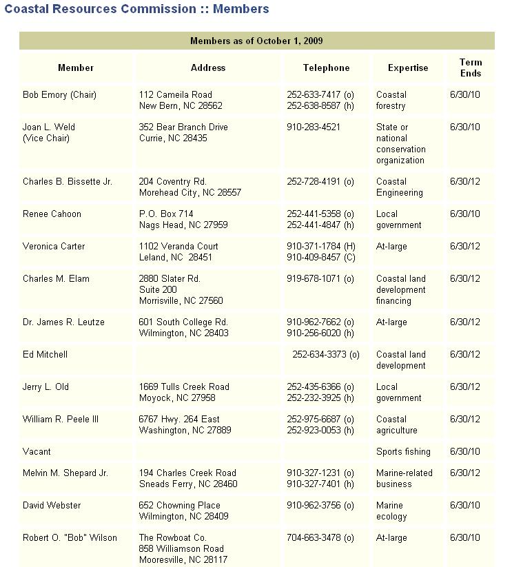
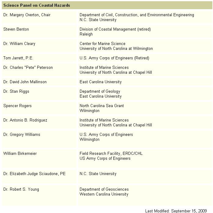
Appendix A. Committee Lists
|
|
|
- Colleen Rice
- 5 years ago
- Views:
Transcription
1 Appendix A Committee Lists
2 THIS PAGE INTENTIONALLY LEFT BLANK
3
4
5 Terminal Groin Study CRC/CRAC Subcommittee Members: o Bob Emory o Jim Leutze o Melvin Shepard o Veronica Carter o Charles Boots Elam o Dara Royal o Spencer Rogers o Anne Deaton o Tracy Skrabal o Bill Morrison
6 THIS PAGE INTENTIONALLY LEFT BLANK
7 Appendix B Session Law House Bill 709
8 THIS PAGE INTENTIONALLY LEFT BLANK
9 GENERAL ASSEMBLY OF NORTH CAROLINA SESSION 2009 SESSION LAW HOUSE BILL 709 AN ACT TO IMPOSE A MORATORIUM ON CERTAIN ACTIONS OF THE COASTAL RESOURCES COMMISSION RELATED TO TEMPORARY EROSION CONTROL STRUCTURES AND TO DIRECT THE COASTAL RESOURCES COMMISSION TO STUDY THE FEASIBILITY AND ADVISABILITY OF THE USE OF A TERMINAL GROIN AS AN EROSION CONTROL DEVICE. The General Assembly of North Carolina enacts: SECTION 1.(a) Definitions and Concepts. The following definitions and concepts apply to Sections 1 of this act and its implementation: (1) "Temporary erosion control structure" means a sandbag structure placed above mean high water and parallel to the shore. (2) A community is considered to be actively pursuing a beach nourishment or inlet relocation project under any of the following circumstances: a. The community has a current and valid Coastal Area Management Act permit for the project. b. The community has been identified by a U.S. Army Corps of Engineers' Beach Nourishment Reconnaissance Study, General Reevaluation Report, Coastal Storm Damage Reduction Study, or an ongoing feasibility study by the U.S. Army Corps of Engineers. c. The community has received a favorable economic evaluation report on a federal project or is in the planning stages of a project that (i) has been designed by the U.S. Army Corps of Engineers or persons meeting applicable State occupational licensing requirements and (ii) has been initiated by a local government or community working toward the identification and adoption of a mechanism to provide the necessary local or State funds to construct the project. SECTION 1.(b) Moratorium Established. Notwithstanding Article 7 of Chapter 113A of the General Statutes and rules adopted pursuant to Article 7, there is hereby established a moratorium on certain actions of the Coastal Resources Commission related to temporary erosion control structures. The Commission shall not order the removal of a temporary erosion control structure that has been permitted under Article 7 of Chapter 113A of the General Statutes in a community that is actively pursuing a beach nourishment project or an inlet relocation project on or before the effective date of this act. SECTION 1.(c) Exceptions. The moratorium on certain actions by the Coastal Resources Commission related to temporary erosion control structures shall not prohibit the Commission from undertaking any of the following actions: (1) Granting permit modifications to allow the replacement, within the originally permitted dimensions, of temporary erosion control structures that have been damaged or destroyed. (2) Requiring the removal of temporary erosion control structures installed in violation of Article 7 of Chapter 113A of the General Statutes and rules adopted pursuant to Article 7. (3) Requiring that a temporary erosion control structure that has been modified in violation of Article 7 of Chapter 113A of the General Statutes and rules adopted pursuant to Article 7 be brought back into compliance with permit conditions. *H709-v-4*
10 (4) Requiring the removal of a temporary erosion control structure that no longer protects an imminently threatened road and associated right-of-way or an imminently threatened building and associated septic system. SECTION 2.(a) Study. The Coastal Resources Commission, in consultation with the Division of Coastal Management, the Division of Land Resources, and the Coastal Resources Advisory Commission, shall conduct a study of the feasibility and advisability of the use of a terminal groin as an erosion control device at the end of a littoral cell or the side of an inlet to limit or control sediment passage into the inlet channel. For the purpose of this study, a littoral cell is defined as any section of coastline that has its own sediment sources and is isolated from adjacent coastal reaches in terms of sediment movement. SECTION 2.(b) Specific Considerations. In conducting the study, the Commission shall specifically consider all of the following: (1) Scientific data regarding the effectiveness of terminal groins constructed in North Carolina and other states in controlling erosion. Such data will include consideration of the effect of terminal groins on adjacent areas of the coastline. (2) Scientific data regarding the impact of terminal groins on the environment and natural wildlife habitats. (3) Information regarding the engineering techniques used to construct terminal groins, including technological advances and techniques that minimize the impact on adjacent shorelines. (4) Information regarding the current and projected economic impact to the State, local governments, and the private sector from erosion caused by shifting inlets, including loss of property, public infrastructure, and tax base. (5) Information regarding the public and private monetary costs of the construction and maintenance of terminal groins. (6) Whether the potential use of terminal groins should be limited to navigable, dredged inlet channels. SECTION 2.(c) Public Input. In conducting the study, the Commission shall hold at least three public hearings where interested parties and members of the general public will have the opportunity to present views and written material regarding the feasibility and advisability of the use of a terminal groin as an erosion control device at the end of a littoral cell or the side of an inlet to limit or control sediment passage into the inlet channel. SECTION 2.(d) Report. No later than April 1, 2010, the Commission shall report its findings and recommendations to the Environmental Review Commission and the General Assembly. SECTION 3. This act is effective when it becomes law. Section 1 of this act expires September 1, In the General Assembly read three times and ratified this the 11 th day of August, s/ Walter H. Dalton President of the Senate s/ Joe Hackney Speaker of the House of Representatives s/ Beverly E. Perdue Governor Approved 1:21 p.m. this 26 th day of August, 2009 Page 2 Session Law SL
11 Appendix C Engineering Activity Logs
12 THIS PAGE INTENTIONALLY LEFT BLANK
13 ENGINEERING ACTIVITIES LOG FOR OREGON INLET No Date Project Type Description Vol (cy) Extent (ft) Unit Vol (cy/ft) Sand Source Dredging USACE begins dredging to maintain a 14' X 400' channel through Oregon Inlet Dredging Oregon Inlet - Hyde (dredge) 62, Dredging Oregon Inlet - Hyde (dredge) 24, Dredging Oregon Inlet - Hyde (dredge) 109, Dredging Oregon Inlet - Hyde (dredge) 76, Dredging Oregon Inlet - Hyde (dredge) 12, Dredging Oregon Inlet - Merrit (dredge) 7, Dredging Oregon Inlet - Hyde (dredge) 188, Dredging Oregon Inlet - Merrit (dredge) 95, Dredging Oregon Inlet - Hyde (dredge) 88, Dredging Oregon Inlet - Merrit (dredge) 98, Dredging Oregon Inlet - Hyde (dredge) 215, Dredging Oregon Inlet - Hyde (dredge) 211, Dredging Oregon Inlet - Merrit (dredge) 85, Dredging Oregon Inlet - Hyde (dredge) 132, Dredging Oregon Inlet - Merrit (dredge) 70, Dredging Oregon Inlet - Hyde (dredge) 40, Dredging Oregon Inlet - Merrit (dredge) 74, Dredging Oregon Inlet - Schweizer (dredge) 55, Dredging Oregon Inlet - Hyde (dredge) 132, Dredging Oregon Inlet - Hyde (dredge) 302, Dredging Oregon Inlet - Merrit (dredge) 22, Dredging Oregon Inlet - Merrit (dredge) 19, Dredging Oregon Inlet - Schweizer (dredge) 40,450
14 No Date Project Type Description Vol (cy) Extent (ft) Unit Vol (cy/ft) Sand Source Dredging Oregon Inlet - Merrit (dredge) 55, Dredging Oregon Inlet - Schweizer (dredge) 164, Dredging Oregon Inlet - Schweizer (dredge) 182, Dredging Oregon Inlet - Schweizer (dredge) 372, Dredging Oregon Inlet - Schweizer (dredge) 312, Dredging g Oregon Inlet - Merrit (dredge) 9, Dredging Oregon Inlet - Schweizer (dredge) 349, Dredging Oregon Inlet - Schweizer (dredge) 415, Dredging Oregon Inlet - Schweizer (dredge) 438, April, 1963 Bridge Opening The 2.4-mile Bonner Bridge opens Dredging Oregon Inlet - Schwiezer (dredge) 438, Dredging Oregon Inlet - Currituck (dredge) 27, Dredging Oregon Inlet - Schwiezer (dredge) 550, Dredging Oregon Inlet - Merrit (dredge) 115, Dredging Oregon Inlet - Schwiezer (dredge) 665, Dredging Oregon Inlet - Merrit (dredge) 279, Dredging Oregon Inlet - Mermentau (dredge) 146, Dredging Oregon Inlet - Schwiezer (dredge) 514, Dredging Oregon Inlet - Merrit (dredge) 221, Dredging Oregon Inlet - Fry (dredge) 152, Dredging Oregon Inlet - Mermentau (dredge) 270, Dredging Oregon Inlet - Mermentau (dredge) 24, Dredging Oregon Inlet - Schweizer (dredge) 356, Dredging Oregon Inlet - Merrit (dredge) 85, Dredging Oregon Inlet - Fry (dredge) 162,835
15 No Date Project Type Description Vol (cy) Extent (ft) Unit Vol (cy/ft) Sand Source Dredging USACE initiates a large scale hopper dredge of Oregon Inlet Dredging Oregon Inlet - Mermentau (dredge) 480, Dredging Oregon Inlet - Mermentau (dredge) 456, Dredging Oregon Inlet - Northerly Island (dredge) 283, Dredging Oregon Inlet - Schweizer (dredge) 377, Dredging Oregon Inlet - Merrit (dredge) 305, Dredging Oregon Inlet - Northerly Island (dredge) 521, Dredging Oregon Inlet - Northerly Island (dredge) 744, Dredging Oregon Inlet - Mermentau (dredge) 365, Dredging Oregon Inlet - Mermentau (dredge) 533, Dredging Oregon Inlet - Currituck (dredge) 41, Dredging Oregon Inlet - Mermentau (dredge) 274, Dredging Oregon Inlet - Northerly Island (dredge) 213, Dredging Oregon Inlet - Atchafalaya (dredge) 290, Dredging Oregon Inlet - Atchafalaya (dredge) 159, Dredging Oregon Inlet - Currituck (dredge) 77, Dredging Oregon Inlet Ocean Bar 292, Beach Nourishment Dredging near Bonner Bridge; placed on tip of Pea Island 254,955 2, Vicinity of Bonner Bridge The project consisted of a terminal groin and revetment (3,125 and 625 ft long) starting at the US Coast Guard Station; the groin ranges in width btw 110 to 170 ft at the base and 25 ft at the landward end to 39 ft at the seaward end; the groin was designed to withstand a still water level of 8 ft above MSL and March 1991 Groin Construction wave btw 9 and 15 ft. 69 April - November, 1991 Beach Nourishment USACE places fill on to the PINWE beach 470, Dredging Oregon Inlet Ocean Bar 230,779 Placed Offshore Dredging Oregon Inlet - Northerly Island (dredge) 182, Dredging Oregon Inlet - Currituck (dredge) 149,503
16 No Date Project Type Description Vol (cy) Extent (ft) Unit Vol (cy/ft) Sand Source Dredging Oregon Inlet - S 480, Dredging Oregon Inlet - Merrit (dredge) 61, November, 1991 Beach Nourishment Placed on Pea Island (sta 60 to 100) 184,300 4, Navigation Span 76 April, 1991 Beach Nourishment Placed on Pea Island (sta 45 to 55 & sta 85 to 100) 282,600 2, Oregon Inlet Navigation Span 77 September, 1992 Beach Nourishment Placed on Pea Island 157,600 1,000 Oregon Inlet Navigation Channel Surveys FRF's Oregon Inlet Monitoring Program surveys extended 6 km north and south of the inlet; survey lines spaced at 300 m intervals and extended offshore to the 9 m depth contour 79 September, 1992 Beach Nourishment Placed on Pea Island (sta 80 to 134) 1,078,000 5, Oregon Inlet Navigation Span Dredging Oregon Inlet - ADCO (dredge) 94, Dredging Oregon Inlet - Georgia (dredge) 900, Dredging Oregon Inlet - Schweizer (dredge) 602, Dredging Oregon Inlet - Merrit (dredge) 88, October, 1993 Beach Nourishment Placed on Pea Island (sta 80 to 105) 433,235 2, Oregon Inlet Navigation Span and Ocean Bar Dredging Oregon Inlet - Currituck (dredge) 18, Dredging Oregon Inlet - Schweizer (dredge) 585, Dredging Oregon Inlet - Merrit (dredge) 55, Beach Nourishment Placed on Pea Island 203,191 2, November, 1995 Beach Nourishment Placed on Pea Island (sta 79 to 80) 65,231 Orgeon Inlet Ocean Bar 90 December, 1995 Beach Nourishment Placed on Pea Island (Nearshore) 168,400 Orgeon Inlet Ocean Bar Dredging Oregon Inlet - Schweizer (dredge) 577, Dredging Oregon Inlet - Atchafalaya (dredge) 250, Dredging Oregon Inlet 233, Beach Nourishment Placed on Pea Island 500, August, 1996 Beach Nourishment Placed on Pea Island (Nearshore) 271,004 Oregon Inlet Navigation Span and Ocean Bar Dredging Oregon Inlet - Mermentau (dredge) 271,004
17 No Date Project Type Description Vol (cy) Extent (ft) Unit Vol (cy/ft) Sand Source Dredging Oregon Inlet - Currituck (dredge) 13, September, 1997 Beach Nourishment Placed on Pea Island (Nearshore) 271,703 Oregon Inlet Navigation Span and Ocean Bar Dredging Oregon Inlet 271, October, 1998 Beach Nourishment Placed on Pea Island (Nearshore) 260,183 Oregon Inlet Navigation Span and Ocean Bar Dredging Oregon Inlet 260, Beach Nourishment Placed on Pea Island (Nearshore) 328,919 Oregon Inlet Navigation Span and Ocean Bar Dredging Oregon Inlet 328, Beach Nourishment Placed on Pea Island 419, October, 2000 Beach Nourishment Placed on Pea Island (Nearshore) 244, Dredging Oregon Inlet 419, November, 2001 Beach Nourishment Placed on Pea Island (sta 40 to 43 & sta 52 to 100) 513, Dredging Oregon Inlet 513, October, 2002 Beach Nourishment Placed on Pea Island (Nearshore & sta 80 to 151) 732, Dredging Oregon Inlet 732, October, 2003 Beach Nourishment Placed on Pea Island (sta 66 to 188) 1,029,543 Oregon Inlet Navigation Span and Ocean Bar Oregon Inlet Navigation Span Oregon Inlet Navigation Span and Ocean Bar Oregon Inlet Navigation Span Beach Nourishment Placed on Pea Island (Nearshore) 107,631 Oregon Inlet Ocean Bar Dredging Oregon Inlet 107, Dredging Oregon Inlet - Merrit (dredge) 50,840 Placed on Pea Island (Nearshore & sta 45 to not 70 to 115 July - November, 2004 Beach Nourishment 90) 616,448 Oregon Inlet Navigation Span and Ocean Bar Dredging Oregon Inlet 147, Dredging Oregon Inlet - Currituck (dredge) 54, November, 2005 Beach Nourishment Placed on Pea Island (Nearshore) 172,155 Oregon Inlet Ocean Bar Dredging Oregon Inlet - Currituck (dredge) 15, Dredging Oregon Inlet - Fry (dredge) 242, Dredging Oregon Inlet - Currituck (dredge) 38,270
18 No Date Project Type Description Vol (cy) Extent (ft) Unit Vol (cy/ft) Sand Source Dredging Oregon Inlet - Fry (dredge) 200, Dredging Oregon Inlet - Merrit (dredge) 255, Dredging Oregon Inlet - Currituck (dredge) 113, Dredging Oregon Inlet - Fry (dredge) 241, Dredging Oregon Inlet - Merrit (dredge) 702, November, 2008 Beach Nourishment Placed on Pea Island (sta 45 to 110) 791, October, 2009 Beach Nourishment Placed on Pea Island (sta 45 to 150) 1,183,144 Oregon Inlet Navigation Span and Ocean Bar Oregon Inlet Navigation Span and Ocean Bar
19 ENGINEERING ACTIVITIES LOG FOR FORT MACON No Date Project Type Description Vol (cy) Extent (ft) Unit Vol (cy/ft) Sand Source Fort Construction Fort Macon Construction Navigational Improvements to Beaufort Inlet begin; Channel dredged to Dredging 300-ft wide Dredging Outer Bar Channel 311, Dredging Outer Bar Channel 156, Dredging Outer Bar Channel 209, Dredging Outer Bar Channel 166, Dredging Outer Bar Channel 56, Dredging Outer Bar Channel 156, Dredging Outer Bar Channel 763,100 Outer Bar Channel deepened to -30 ft and 400-ft wide; channel location Dredging becomes fixed Dredging Morehead City Harbor Channel Maintenance 2,367, Dredging g Outer Bar Channel 3,460, Dredging Morehead City Harbor Channel Maintenance 215, Dredging Outer Bar Channel 268, Dredging Morehead City Harbor Channel Maintenance 55, Dredging Outer Bar Channel 205, Dredging Morehead City Harbor Channel Maintenance 35, Dredging Outer Bar Channel 473, Dredging Morehead City Harbor Channel Maintenance 262, Dredging Outer Bar Channel 918, Dredging Outer Bar Channel 299, Dredging Morehead City Harbor Channel Maintenance 10, Dredging Outer Bar Channel 91, Dredging Morehead City Harbor Channel Maintenance 727,600
20 No Date Project Type Description Vol (cy) Extent (ft) Unit Vol (cy/ft) Sand Source Dredging Outer Bar Channel 584, Dredging Morehead City Harbor Channel Maintenance 141, Dredging Outer Bar Channel 520, Dredging Morehead City Harbor Channel Maintenance 193, Dredging Outer Bar Channel 145, Dredging Morehead City Harbor Channel Maintenance 119, Dredging Outer Bar Channel 48, Dredging Morehead City Harbor Channel Maintenance 174, Dredging Outer Bar Channel 542, Dredging Outer Bar Channel 1,103, Dredging Morehead City Harbor Channel Maintenance 101, Dredging Outer Bar Channel 637, Dredging Outer Bar Channel 616, Dredging Outer Bar Channel 504, Dredging Morehead City Harbor Channel Maintenance 230, Dredging Outer Bar Channel 312, Dredging Outer Bar Channel 797, Dredging Morehead City Harbor Channel Maintenance 166, Dredging Outer Bar Channel 719, Dredging Outer Bar Channel 564, Dredging Morehead City Harbor Channel Maintenance 177, Dredging Outer Bar Channel 1,039, Dredging Outer Bar Channel 866, Dredging Morehead City Harbor Channel Maintenance 196, Dredging Outer Bar Channel 977,400
21 No Date Project Type Description Vol (cy) Extent (ft) Unit Vol (cy/ft) Sand Source Dredging Morehead City Harbor Channel Maintenance 130, Dredging Outer Bar Channel 589, Beach Nourishment 7656 Due to financial constraints, the groin was only built to a length of 720 ft at an elevation of 6 ft and excluded the structure's top armor layer. The revetment (250 ft) and seawall (530 ft) were constructed along the dune Seawall, Revetment, Partial Groin Construction southeastern direction bank starting just north of the present-day Fort Macon parking lot in a southeastern direction Dredging Morehead City Harbor Channel Maintenance 1,336, Dredging Outer Bar Channel 1,869, Dredging Outer Bar Channel 898, Dredging Outer Bar Channel 584, Dredging Morehead City Harbor Channel Maintenance 509, Dredging Outer Bar Channel 407,800 Groin extended an additional 410 ft oceanward; Additional groin was constructed west of the revetment due to extensive erosion on the back, Groin Extention & Construction; Beach Nourishment or sound side, of the island and its impact to the US Coast Guard station. Beach fill was also placed on the beach between the present day bathhouse and boardwalk region and the terminal groin 93, Dredging Outer Bar Channel 655, Dredging Morehead City Harbor Channel Maintenance 253, Dredging Outer Bar Channel 691, Dredging Outer Bar Channel 966, Dredging Morehead City Harbor Channel Maintenance 178, Dredging Outer Bar Channel 708, Dredging Morehead City Harbor Channel Maintenance 72, Dredging Outer Bar Channel 401, Dredging Morehead City Harbor Channel Maintenance 431, Dredging Outer Bar Channel 853,900 Disposal: ODMDS
22 No Date Project Type Description Vol (cy) Extent (ft) Unit Vol (cy/ft) Sand Source (aug) Groin Extention & Construction; Beach Nourishment Groin extended an additional 400 ft to a total length of 1,530 ft; A stone groin (480 ft long) was built near the bathhouse in an effort to stabilize the beach fill placed in the area of the bathhouse and boardwalk 100, Dredging Outer Bar Channel 913, Dredging Outer Bar Channel 783, Beach Nourishment 504, State Port (Morehead City Harbor) Dredging Outer Bar Channel 952, Dredging Morehead City Harbor Channel Maintenance 557, Dredging Outer Bar Channel 401,600 Disposal: ODMDS Dredging Outer Bar Channel - Gerig 238,289 Disposal: ODMDS Dredging Outer Bar Channel - Goethals 190,397 Disposal: ODMDS Dredging Outer Bar Channel - Davison 74,685 Disposal: ODMDS Dredging Outer Bar Channel - Gerig 583,929 Disposal: ODMDS Dredging Outer Bar Channel - Macfarland 96,133 Disposal: ODMDS Dredging Outer Bar Channel - Landfitt 1,364,069 Disposal: ODMDS Dredging Outer Bar Channel - Sensibar 1,608,131 Disposal: ODMDS Dredging Morehead City Harbor Channel Maintenance 164, Dredging Morehead City Harbor Channel Maintenance - Pullen 1,179, Dredging Outer Bar Channel - Landfitt 530,008 Disposal: ODMDS Beach Nourishment USACE Maintenance Dredge of Morehead City Inner Harbor 1,179, Morehead City Inner Harbor Dredging Outer Bar Channel 294, Dredging Outer Bar Channel - Dodge Island 824,052 Disposal: ODMDS Dredging Morehead City Harbor Channel Maintenance - Hampton Roads 589, Dredging Morehead City Harbor Channel Maintenance - Hampton Roads 22, Dredging Outer Bar Channel - Manhattan 977,040 Disposal: ODMDS Dredging Morehead City Harbor Channel Maintenance - Hampton Roads 263,609 Disposal: ODMDS
23 No Date Project Type Description Vol (cy) Extent (ft) Unit Vol (cy/ft) Sand Source Dredging Outer Bar Channel - Dodge Island 848,933 Disposal: ODMDS Dredging Outer Bar Channel 1,098, Dredging Outer Bar Channel - Sugar Island 583,181 Disposal: ODMDS Dredging Morehead City Harbor Channel Maintenance - Clinton 153,625 USACE Maintenance Dredge of Morehead City Inner Harbor and Brandt Beach Nourishment Island Pump out; placed on Atlantic Beach 4,168, Morehead City Inner Harbor / Brandt Island Dredging Morehead City Harbor Channel Maintenance - Jim Bean 3,912, Dredging Outer Bar Channel 367, Dredging Morehead City Harbor Channel Maintenance 255, Dredging Morehead City Harbor Channel Maintenance - Enterprise 351, Dredging Outer Bar Channel - Sugar Island 534,555 Disposal: ODMDS Dredging Outer Bar Channel - Dodge Island 691,190 Disposal: ODMDS Dredging Outer Bar Channel - Atchafalaya 539,192 Disposal: ODMDS Dredging Morehead City Harbor Channel Maintenance 269, Dredging Outer Bar Channel - Cherokee 592,232 Disposal: ODMDS Dredging Outer Bar Channel 11, Dredging Morehead City Harbor Channel Maintenance 143, Dredging Outer Bar Channel Eagle 831,637 Disposal: ODMDS Dredging Outer Bar Channel 837,573 Disposal: ODMDS 113 November February 1994 Beach Nourishment USACE Maintenance Dredge of Morehead City Inner Harbor 2,192,268 24,737 (total) Morehead City Inner Harbor 114 November February 1994 Beach Nourishment USACE Brandt Island Pump Out 2,472,132 24,737 (total) Brandt Island Dredging Morehead City Harbor Channel Maintenance 4,664, Dredging Outer Bar Channel 2,606,922 Disposal: ODMDS Dredging Morehead City Harbor Channel Maintenance 815,579 Disposal: ODMDS Dredging Outer Bar Channel 656,646 Disposal: ODMDS Dredging Morehead City Harbor Channel Maintenance 739,584
24 No Date Project Type Description Vol (cy) Extent (ft) Unit Vol (cy/ft) Sand Source Dredging Outer Bar Channel 191,872 Disposal: ODMDS Dredging Outer Bar Channel 1,163, Dredging Morehead City Harbor Channel Maintenance 18, Dredging Outer Bar Channel 1,040, Dredging Morehead City Harbor Channel Maintenance 350, June & September, 1999 Survey CSE surveys for Carteret County Dredging Outer Bar Channel 1,701, June, 2000 Survey CSE surveys for Carteret County 128 February, 2002 Beach Nourishment USACE Maintenance Dredge of Morehead City Inner Harbor 209,348 Morehead City Inner Harbor 129 December, 2003 Survey CSE surveys for Carteret County Dredging Morehead City Harbor Channel Maintenance 2,940,507 Disposal: ODMDS Dredging Morehead City Harbor Channel Maintenance 1,577,052 Disposal: ODMDS 132 June, 2004 Survey CSE surveys for Carteret County November February Beach Nourishment USACE Brandt Island Pump Out; placed on Atlantic Beach 2,390,000 22,543 (total) Dredging Morehead City Harbor Channel Maintenance 906,716 Disposal: ODMDS 135 January - March, 2005 Beach Nourishment USACE Maintenance Dredge of Morehead City Inner Harbor 530,729 12,500 (total) Morehead City Inner Harbor 136 May, 2005 Survey CSE surveys for Carteret County 137 May, 2006 Survey CSE surveys for Carteret et County 138 May, 2007 Survey CSE surveys for Carteret County Beach Nourishment Morehead City Inner Harbor Maintenance Dredging (Range C, Bulkhead Channel) 211,000 Morehead City Inner Harbor (Range C Bulkhead Channel)
25 ENGINEERING ACTIVITIES LOG FOR AMELIA ISLAND No Date Project Type Description Vol (cy) Extent (ft) Unit Vol (cy/ft) Sand Source Revetment Construction In response to erosion damage from Hurricane Dora (1964), emergency Federal funds were appropriated for construction of granite stone revetments along approximately 1.1 miles of American Beach 's Beach Scraping Amelia Island Plantation (AIP) conducted beach scraping along its shoreline. The effort consisted of seasonal scraping of sand from the intertidal beach zone and subsequent placement at the dune toe Permitted beach scraping was conducted between monuments R-64 and r-68. The project was undertaken by the AIP and constructed in a Beach Scraping manner consistent with previous scraping efforts 32,000 Between January and March, the AIP placed material via truck haul from the Atlantic Intracostal Waterway (AIWW) dredge spoil disposal site within the Amelia Island State Recreation Area (AISRA) located at the 4 January - March, 1984 Beach Nourishment southern end of Amelia Island 76,000 7, AIWW dredge spoil As an emergency response to the Thanksgiving Day Storm of 1984, an additional 5,500 cy of sand were trucked in from the AIWW spoil site and placed at various locations where breaching of the AIP dune system was Beach Nourishment considered imminent 5,500 AIWW dredge spoil As part of a larger island-wide 1.42 mcy beach fill project, 515,000 cy of material were placed by the USACE along a 1.3 mile each of shoreline between R-48 and R-55. The material was obtained from new work dredging of the St. Mary's Entrance required to provide navigational access for the US Navy's submarines. The disposal project was undertaken as a result of a 1986 Memorandum of Understanding Beach Nourishment between the US Navy and the State of Florida 515,000 6, St. Mary's Entrance USACE placed 2.13 mcy of material in a nearshore disposal site located between R-33 and R-55. The material placed was obtained from the new work dredging of St. Mary's Entrance. The material was placed seaward of the -18 ft (MLW) contour, and primarily in deeper water *-20 to -35 ft, Nearshore Disposal MLW) 2,130,000 St. Mary's Entrance Beach Nourishment Beach Nourishment Beach Nourishment USACE placed material along approximately 1 mile of shoreline between R-55 and R-60. The material was originally placed in the USACE nearshore disposal site by hopper dredge, then later moved onshore by means of a cutterhead dredge. The volume actually placed on the beach is a matter of dispute. The dredging contractor was paif for the placement of mcy of fill, intended to extend over the 12,000-ft reach of shoreline between R-54 and R-65. Actual placement of material occurred along approximately 5,000 ft of shoreline between R-55 and R-60. This resulted in an approximate 60% shortfall in project length relative to the original design. Anecdotal visual inspection indicated that much of the material was fine sands and clay, which in all probability resulted from over-dredging of the specified nearshore rehandling site. 750,000 5, AIP placed beach fill material along its shoreline. The material was trucked in from an AIWW dredge spol disposal site located west of the Amelia River 50,000 AIP placed beach fill, from an upland source, along its shoreline as part of a continuing dune protection project 12,000 AIWW (west of Amelia River) dredge spoil
26 No Date Project Type Description Vol (cy) Extent (ft) Unit Vol (cy/ft) Sand Source 11 Winter, 1992/1993 Erosion Control For purposes of "holding the line" until a comprehensive shore-protection solution could be developed, some 10,000 ft of 60" diameter sand-filled geotextile tubes were installed along the existing dune line to protect development Beach Nourishment USACE beach fill along South American Beach extending south to about R , Beach Nourishment SAISS-MSBU constructed a comprehensive beach restoration project along the southernmost 17,000 feet of Amelia Island's shoreline. The project placed fill between monuments R-62 and R-78. The borrow area for the site was 800-ft wide by 7,500-ft long and located between 3,000 and 3,900 feet offshore of the southern end of the island on the margins of the Nassau Sound ebb shoal platform 2,600, Offshore of southern end of island on Nassau Sound ebb shoal platform 14 August - November, 1995 Temporary Terminal Groin Consists of four groins placed perpendicular to the shoreline, spaced about 500 ft apart in a tapered configuration. The groins were constructed of 70" diameter, sand-filled geotextile tubes (LONGARD) and numerous smaller support tubes. The landward terminus of each groin was installed below grade withing the 1994 beach fill The southernmost groin, G-4, was vandalized in October, resulting in deflation of a 50-ft section of the geotextile groin. The gap was closed 15 October, 1996 Terminal Groin Repair through the placement of several small tube sections Between May and September, USACE placed fill along 4,500 ft of shoreline between monuments R-77.5 and R The sand was obtained from maintenance dredging of the AIWW through Nassau Sound. Fill was placed within the groin field as well as along the beach AIWW dredge spoil through 16 May - September, 1997 Beach Nourishment 1,000 ft north and 2,000 ft south of the structures 300, , Nassau Sound Terminal Groin Repair All four groins have been routinely vandalized, resulting in substantial structural damage and sand loss. The seaward terminus of each groin required major reconstruction during which the decision was made to truncate each structure, thereby creating the current groin configuration. Additional stablizing bags were also added to groin, G-4, at this time. In October, groin, G-3, was rendered ineffective 18 November - December, 2000 Flood Protection 19 May - September, 2001 Beach Nourishment Approximately 2,000 ft of shore-parallel sand-filled geotextile tubes were placed along segments of the AISRA to reduce flooding of the maritime forest in areas where the dune had been lost to chronic erosion. USACE placed fill along 4,500 ft of shoreline between monuments R-77.5 and R The sand was obtained from maintenance dredging of the AIWW through Nassau Sound. Fill was placed within the groin field as well as along the beach 1,000 ft north and 2,000 ft south of the structures 300,000 4, AIWW dredge spoil through Nassau Sound 20 June, 2002 Survey Pre-construction (2002 Shore Stabilization Project) Groin Removal / Beach Nourishment Phase 1 of the South Amelia Island Shore Stabilization Project was constructed between monuments R-79 and R-60 along Amelia Island State Park and northward thereof. Prior to construction, all shore-parallel and shore-perpendicular geotextil structures are removed 1,800, August, 2002 Survey Post-Construction (2002 Shore Stabilization Project)
27 No Date Project Type Description Vol (cy) Extent (ft) Unit Vol (cy/ft) Sand Source 23 May, 2003 Survey 9-Months Post Construction (collected independently by FDEP) 24 October, 2003 Survey 14-Months Post Construction 25 March, 2004 Survey 19-Months Post Construction /2005 Breakwater / Groin Construction Phase 2 of the South Amelia Island Shore Stabilization Project was constructed consisting of 3 engineered rubble mound erosion control structures, a detached breakwater and two groins, including a "leaky" terminal groin at the south end of the island in an east-west orientation 27 March, 2005 Survey 31-Months Post Construction 28 September, 2005 Survey 37-Months Post Construction Beach Nourishment USACE placed fill onto the south Amelia Island beaches between the detached breakwater and the terminal groin, or between monuments R- 76 to R , July, 2006 Survey 47-Months Post Construction 31 June, 2007 Survey 58-Months Post Construction 32 July, 2008 Survey Condition surveys for each structure including adjacent beaches; beach profiles from R-55 to R-82; including half-stations between R-73 and R- 82; Bathymetric surveys of Nassau Sound (including borrow areas)
28 ENGINEERING ACTIVITIES LOG FOR CAPTIVA ISLAND No Date Project Type Description Vol (cy) Extent (ft) Unit Vol (cy/ft) Sand Source Seawalls & Revetment s s Construction Extensive Seawalls and Revetments are placed Groin Construction & Beach 134 Groins are constructed on Captiva Island; fill placed along Captiva Nourishment Island 107, Groin Construction 2 timber groins are constructed at the middle of captiva Island 4 November - December, 1973 Beach Nourishment Fill placed on Captiva Island 5,000 5 July, 1976 Jetty Construction The recently constructed jetty is deemed to be a navigation hazard Groin Construction A 350-ft rock groin is constructed at the north end of Captiva Island at Redfish Pass; a 1,500 foot long rubble rock revetment is constructed at the Gulf beach at the north end of Captiva Island Beach Nourishment Fill placed on South Seas Resort 655,000 Groin Construction & Beach Nourishment Fill placed on Captiva Island & Blind Pass Groin constructed 1,600, Beach Nourishment Fill placed on SO. Seas Plantation Beach Nourishment Fill placed along Captiva Island 821, Beach Nourishment Fill placed on Captiva Island 1,017,000 Groin Reconstruction & 12 July, 2006 Extention Redfish Pass Groin reconstructed and extended 13 April, 2008 Beach Nourishment Fill placed on Captiva Island 100,000
29 ENGINEERING ACTIVITIES LOG FOR JOHN'S PASS No Date Project Type Description Vol (cy) Extent (ft) Unit Vol (cy/ft) Sand Source Bridge Construction Groin Construction Groin Construction Groin Construction Jetty Construction & Beach Nourishment Pinellas County constructed bridges across Blind Pass & Johns Pass and built a road on Treasure Island Two 150-ft groins are built on the Veteran's Administration Beach at Madeira Beach The City of Madeira Beach builds a groin field of 37 groins over its entire frontage. These groins were constructed of timber piles with adjustable timber and concrete panels The City of Treasure Island installs a groin field of 56 groins on the southern frontage of Treasure Island. 94,000 cy of material is dredged from Johns Pass and placed on the outer bar of Johns Pass (20, ft offshore) 94,000 A 460-ft curved jetty is installed on the north side of Johns Pass, and fill is placed on the beach north of Johns Pass 30, Beach Nourishment Fill placed on Sunset Beach (Treasure Island) 10,000 Dredge from Blind Pass Dredging Channel Maintenance 77, Revetment Construction A 920-ft long revetment is placed along the south bank of Johns Pass Bridge Construction New bridge over Johns Pass is completed Beach Nourishment Fill placed on Treasure Island 790,000 1, Dredge from Blind Pass Beach Nourishment Fill placed on Treasure Island 75,000 1, Dredge from Johns Pass Beach Nourishment Fill placed on Treasure Island 150,000 1, Survey Beach Profile Surveys for Treasure Island Groin Construction & Beach Nourishment USACE begins construction of 2 impermeable sheet pile groins and the third periodic nourishment of Treasure Island beaches north of Blind Pass. The groin at the southern end of Treasure Island is 360-ft long and the 2nd groin (2,300 ft north of the first) is 285-ft long 404, Beach Nourishment & Groin Extention Fill placed on southern portion of Treasure Island; Groin extended and stabilized at south end of island 380,000 7, offshore borrow area 16 December, 1978 Beach Nourishment Fill placed on southern Treasure Island 32,000 Dredge from Blind Pass Dredging Channel Maintenance 80, Dredging Channel Maintenance 70, Dredging Channel Maintenance 80, Beach Nourishment Fill placed on Treasure Island 220,000 Emergency Beach Nourishment Repairs to Treasure Island 549,000
30 No Date Project Type Description Vol (cy) Extent (ft) Unit Vol (cy/ft) Sand Source Beach Nourishment Initial Fill placed on North Redington Beach Groin Rehabilitation Rehabilitation of Groin at Johns Pass completed Dredging Channel Maintenance 56,000 Fill placed on Sunset Beach (Treasure Island) & northern 2,400 feet of 25 June, 1996 Beach Nourishment Long Key 252,950 Egmont Shoal Dredging Channel Maintenance 390, Groin Construction Terminal groin constructed on the south side of John's Pass 28 May, 2000 Beach Nourishment Fill placed along the northern 2,400 feet of Long Key & Sunset Beach (Treasure Island) 358,900 2, Blind Pass & Johns Pass 29 August, 2000 Beach Nourishment Fill placed along Sunset Beach (Treasure Island) between monuments DNR-136 and DNR ,000 Blind Pass & Johns Pass Fill placed along southern third of Treasure Island between monuments 30 September, 2004 Beach Nourishment DNR-136 and DNR-141. Following Hurricane Jeanne, additional fill was placed along Sunset Beach to complete segment and repair damages due to the storm 225,422 5, February, 2006 Survey Beach Profile Surveys done for Long Key & Treasure Island 32 August, 2006 Beach Nourishment Fill placed on Sunshine Beach & Sunset Beach (Treasure Island) 184,272 Egmont Shoal 33 December, 2006 Survey Beach Profile Surveys done for Long Key & Treasure Island 34 August, 2007 Survey Beach Profile Surveys done for Long Key & Treasure Island 35 October, 2008 Survey Beach Profile Surveys done for Long Key & Treasure Island Dredging Channel Maintenance 375,000
31 Appendix D Physical Data
32 THIS PAGE INTENTIONALLY LEFT BLANK
33 NC TERMINAL GROIN STUDY FINAL REPORT Appendix D Physical Data 1. Oregon Inlet a) Waves and Tides For the Oregon Inlet site, the closest NDBC buoys and WIS stations were selected to represent wave conditions within the immediate area surrounding the Oregon Inlet terminal groin. These locations are shown in Figure D-1 along with nearby NOAA tidal gages. The closest tide gage is located at the Oregon Inlet Marina, which is inside the sound, not on the oceanside. The closest ocean tidal measurements are approximately 30 miles north at Duck, NC. Table D-1 presents the tidal datums for both gages. Table D-1. Tidal Gages near Oregon Inlet Tidal Datum Station Oregon Inlet Marina ( ) Duck ( ) MHHW (ft) MHW (ft) DTL (ft) MTL (ft) MSL (ft) MLW (ft) MLLW (ft) NAVD (ft) Maximum (ft) Max Date 1999/09/ /08/30 Max Time 15:00 15:54 Minimum (ft) Min Date 1996/03/ /03/16 Min Time 21:48 12:54 March 2010 D-1 Final Report

34 NC TERMINAL GROIN STUDY FINAL REPORT Figure D-1. Wave and Tidal Stations near Oregon Inlet March 2010 D-2 Final Report
35 NC TERMINAL GROIN STUDY FINAL REPORT Table D-2 and Table D-3 summarize the percent occurrences by wave height and direction for WIS stations ATL 223 and 224. Figure D-2 illustrates the average annual wave roses for both stations. The wave rose provides a graphical representation of the wave heights and directions from which the waves are coming. Table D-2. WIS Percent Occurrence of Wave Heights Wave Height (meters) Percent Occurrence of Wave Height Station ATL 223 Station ATL GREATER Table D-3. WIS Percent Occurrence by Mean Wave Direction (From) Direction Band & Center (deg) Percent Occurrence of Mean Direction Station ATL 223 Station ATL (0.0) (22.5) (45.0) (67.5) (90.0) (112.5) (135.0) (157.5) (180.0) (202.5) (225.0) (247.5) (270.0) (292.5) (315.0) (337.5) March 2010 D-3 Final Report
36 NC TERMINAL GROIN STUDY FINAL REPORT Figure D-2. Wave Roses (USACE WIS Hindcast) A review of the WIS hindcast data yields the following observations: Almost 40% of the wave heights over the period were between approximately meters ( feet). The typical direction of the waves was from northeast - southeast. The largest waves occur during the winter months (December March) and are predominately from the north. March 2010 D-4 Final Report

37 NC TERMINAL GROIN STUDY FINAL REPORT b) Storms The NOAA database of historical storms records approximate storm track, wind speed, pressure, and category for storms since Figure D-3 illustrates the hurricane tracks in the vicinity of Oregon Inlet and Table D-4 lists the extratropical storms, tropical storms, and hurricanes that have passed within 65 nautical miles between 1851 and Of these 98 storms, three have made landfall within 10 miles. Figure D-3. Hurricanes in the Vicinity of Oregon Inlet March 2010 D-5 Final Report
38 NC TERMINAL GROIN STUDY FINAL REPORT Table D-4. Oregon Inlet Storms (NOAA, ) YEAR STORM NAME MAXIMUM CATEGORY 1851 NOTNAMED Tropical Storm 1852 NOTNAMED Tropical Storm 1854 NOTNAMED Tropical Storm 1856 NOTNAMED Tropical Storm 1856 NOTNAMED Tropical Storm 1857 NOTNAMED Category NOTNAMED Category NOTNAMED Tropical Storm 1861 NOTNAMED Tropical Storm 1861 NOTNAMED Category NOTNAMED Tropical Storm 1866 NOTNAMED Category NOTNAMED Category NOTNAMED Category NOTNAMED Tropical Storm 1882 NOTNAMED Tropical Storm 1885 NOTNAMED Category NOTNAMED Extratropical 1888 NOTNAMED Tropical Storm 1889 NOTNAMED Tropical Storm 1893 NOTNAMED Tropical Storm 1893 NOTNAMED Tropical Storm 1893 NOTNAMED Tropical Storm 1893 NOTNAMED Tropical Storm 1894 NOTNAMED Category NOTNAMED Tropical Storm 1897 NOTNAMED Tropical Storm 1897 NOTNAMED Tropical Storm 1897 NOTNAMED Tropical Storm 1899 NOTNAMED Category NOTNAMED Extratropical 1901 NOTNAMED Category NOTNAMED Tropical Storm 1907 NOTNAMED Extratropical 1908 NOTNAMED Category NOTNAMED Category NOTNAMED Tropical Storm 1910 NOTNAMED Tropical Storm 1910 NOTNAMED Extratropical 1912 NOTNAMED Extratropical 1918 NOTNAMED Tropical Storm 1924 NOTNAMED Category NOTNAMED Extratropical 1932 NOTNAMED Tropical Storm 1933 NOTNAMED Category NOTNAMED Category NOTNAMED Extratropical 1936 NOTNAMED Category NOTNAMED Tropical Storm 1938 NOTNAMED Extratropical YEAR STORM NAME MAXIMUM CATEGORY 1942 NOTNAMED Extratropical 1944 NOTNAMED Category NOTNAMED Tropical Storm 1946 NOTNAMED Tropical Storm 1946 NOTNAMED Extratropical 1947 NOTNAMED Extratropical 1953 BARBARA Category CAROL Category EDNA Category CONNIE Category IONE Category FLOSSY Extratropical 1958 HELENE Category DONNA Category ALMA Category CLEO Tropical Storm 1964 DORA Tropical Storm 1964 ISBELL Extratropical 1965 NOTNAMED Extratropical 1967 DORIA Tropical Storm 1968 GLADYS Category ALMA Extratropical 1971 DORIA Tropical Storm 1972 AGNES Tropical Storm 1981 BRET Tropical Storm 1981 DENNIS Tropical Storm 1984 DIANA Tropical Storm 1985 GLORIA Category CHARLEY Category BOB Category DANIELLE Tropical Storm 1993 EMILY Category ALLISON Extratropical 1996 ARTHUR Tropical Storm 1996 JOSEPHINE Extratropical 1997 DANNY Tropical Storm 1998 BONNIE Category EARL Extratropical 1999 FLOYD Category HELENE Tropical Storm 2002 GUSTAV Tropical Storm 2002 KYLE Tropical Storm 2004 ALEX Category CHARLEY Tropical Storm 2004 CHARLEY Extratropical 2006 ALBERTO Extratropical 2007 GABRIELLE Tropical Storm 2007 BARRY Extratropical 2008 CRISTOBAL Tropical Storm March 2010 D-6 Final Report
39 NC TERMINAL GROIN STUDY FINAL REPORT 2. Fort Macon a) Waves and Tides The closest NDBC buoys and USACE Wave Information Study hindcast points (WIS stations) near Fort Macon that represent wave conditions within the immediate area surrounding Beaufort Inlet and the terminal groin are shown in Figure D-4 along with nearby NOAA tidal gages. The closest operating tidal gage is located in Beaufort Inlet with another located on the ocean shore approximately 70 miles to the southwest at Wrightsville Beach. Table D-5 presents the tidal datums for both gages. Table D-5. Tidal Gages near Fort Macon Station Tidal Datum Beaufort ( ) Wrightsville Beach ( ) MHHW (ft) MHW (ft) DTL (ft) MTL (ft) MSL (ft) MLW (ft) MLLW (ft) NAVD (ft) Maximum (ft) Max Date 1999/09/ /09/25 Max Time 9:12 20:54 Minimum (ft) Min Date 1978/01/ /04/16 Min Time 3:18 4:24 March 2010 D-7 Final Report
 March")
40 NC TERMINAL GROIN STUDY FINAL REPORT Figure D-4. Wave and Tidal Stations near Fort Macon (Beaufort Inlet) March 2010 D-8 Final Report
41 NC TERMINAL GROIN STUDY FINAL REPORT Table D-6 and Table D-7 summarize the percent occurrences by wave height and direction for WIS stations ATL 274 and 275. Figure D-5 illustrates the average annual wave roses for both stations. These wave roses provide a graphical representation of the wave heights and directions from which the waves are coming. Table D-6. WIS Percent Occurrence of Wave Heights Wave Height (meters) Percent Occurrence of Wave Height Station ATL 274 Station ATL GREATER Table D-7. WIS Percent Occurrence by Mean Wave Direction (From) Direction Band & Center (deg) Percent Occurrence of Mean Direction Station ATL 274 Station ATL (0.0) (22.5) (45.0) (67.5) (90.0) (112.5) (135.0) (157.5) (180.0) (202.5) (225.0) (247.5) (270.0) (292.5) (315.0) (337.5) March 2010 D-9 Final Report
 A review of the WIS hindcast data yields the following observations: Almost 50% of the wave heights over the hindcast period (1980 1999) were between approximately 0.")
42 NC TERMINAL GROIN STUDY FINAL REPORT Figure D-5. Wave Roses (USACE WIS Hindcast) A review of the WIS hindcast data yields the following observations: Almost 50% of the wave heights over the hindcast period ( ) were between approximately meters ( feet). The typical direction of the waves was from south southwest. However, from August to November the typical direction of the waves is from the east - southeast The largest waves occur during the winter months (December March). March 2010 D-10 Final Report

43 NC TERMINAL GROIN STUDY FINAL REPORT b) Storms The NOAA database of historical storms records approximate storm track, wind speed, pressure, and category for storms since Figure D-6 illustrates the hurricane tracks in the vicinity of Fort Macon and Table D-8 lists the extratropical storms, tropical storms, and hurricanes that have passed within 65 nautical miles between 1851 and Of these 117 storms, 9 have made landfall within 10 miles. Figure D-6. Hurricanes in the Vicinity of Fort Macon March 2010 D-11 Final Report
44 NC TERMINAL GROIN STUDY FINAL REPORT Table D-8. Fort Macon Storms (NOAA, ) YEAR STORM MAXIMUM NAME CATEGORY 1852 NOTNAMED Tropical Storm 1852 NOTNAMED Tropical Storm 1856 NOTNAMED Tropical Storm 1856 NOTNAMED Tropical Storm 1857 NOTNAMED Category NOTNAMED Category NOTNAMED Category NOTNAMED Tropical Storm 1868 NOTNAMED Tropical Storm 1871 NOTNAMED Tropical Storm 1871 NOTNAMED Tropical Storm 1872 NOTNAMED Tropical Storm 1873 NOTNAMED Tropical Storm 1876 NOTNAMED Category NOTNAMED Tropical Storm 1878 NOTNAMED Tropical Storm 1878 NOTNAMED Category NOTNAMED Category NOTNAMED Category NOTNAMED Tropical Storm 1882 NOTNAMED Category NOTNAMED Category NOTNAMED Category NOTNAMED Category NOTNAMED Category NOTNAMED Tropical Storm 1888 NOTNAMED Tropical Storm 1889 NOTNAMED Tropical Storm 1893 NOTNAMED Tropical Storm 1893 NOTNAMED Tropical Storm 1893 NOTNAMED Tropical Storm 1893 NOTNAMED Tropical Storm 1893 NOTNAMED Tropical Storm 1894 NOTNAMED Tropical Storm 1894 NOTNAMED Tropical Storm 1897 NOTNAMED Tropical Storm 1897 NOTNAMED Tropical Storm 1899 NOTNAMED Category NOTNAMED Extratropical 1900 NOTNAMED Extratropical 1901 NOTNAMED Category NOTNAMED Tropical Storm 1901 NOTNAMED Tropical Storm 1904 NOTNAMED Extratropical 1907 NOTNAMED Tropical Storm 1907 NOTNAMED Tropical Storm 1908 NOTNAMED Category NOTNAMED Category NOTNAMED Tropical Storm 1908 NOTNAMED Tropical Storm YEAR STORM MAXIMUM NAME CATEGORY 1908 NOTNAMED Tropical Storm 1908 NOTNAMED Tropical Storm 1910 NOTNAMED Tropical Storm 1910 NOTNAMED Extratropical 1912 NOTNAMED Extratropical 1913 NOTNAMED Category NOTNAMED Category NOTNAMED Extratropical 1925 NOTNAMED Extratropical 1928 NOTNAMED Tropical Storm 1932 NOTNAMED Tropical Storm 1933 NOTNAMED Category NOTNAMED Tropical Storm 1934 NOTNAMED Category NOTNAMED Tropical Storm 1938 NOTNAMED Extratropical 1942 NOTNAMED Tropical Storm 1944 NOTNAMED Category NOTNAMED Tropical Storm 1946 NOTNAMED Tropical Storm 1949 NOTNAMED Category BARBARA Category FLORENCE Extratropical 1954 CAROL Category CONNIE Category IONE Category FLOSSY Extratropical 1958 HELENE Category BRENDA Tropical Storm 1960 DONNA Category ALMA Tropical Storm 1964 DORA Tropical Storm 1964 ISBELL Category ALMA Tropical Storm 1967 DORIA Tropical Storm 1968 GLADYS Category DORIA Tropical Storm 1971 GINGER Category AGNES Tropical Storm 1975 AMY Tropical Storm 1975 HALLIE Tropical Storm 1981 DENNIS Tropical Storm 1984 DIANA Category GLORIA Category KATE Tropical Storm 1986 CHARLEY Category ALLISON Extratropical 1996 ARTHUR Tropical Storm 1996 BERTHA Category JOSEPHINE Extratropical March 2010 D-12 Final Report
45 NC TERMINAL GROIN STUDY FINAL REPORT YEAR STORM NAME MAXIMUM CATEGORY 1998 BONNIE Category DENNIS Tropical Storm 1999 FLOYD Category IRENE Category KYLE Tropical Storm 2003 ISABEL Category ALEX Category CHARLEY Tropical Storm 2005 OPHELIA Category ALBERTO Extratropical 2007 GABRIELLE Tropical Storm 2007 BARRY Extratropical 2008 CRISTOBAL Tropical Storm March 2010 D-13 Final Report
46 NC TERMINAL GROIN STUDY FINAL REPORT 3. Amelia Island a) Waves and Tides The closest NDBC buoys and WIS stations near Amelia Island that represent wave conditions within the immediate area surrounding the terminal groin are shown in Figure D-7 along with nearby NOAA tidal gages. The closest operating tidal gage is located at the Nassau River entrance with a second nearby gage approximately 9 miles south at Mayport. Table D-9 lists the tidal datums for both gages. Table D-9. Tidal Gages near Amelia Island Station Tidal Datum MHHW (ft) MHW (ft) DTL (ft) MTL (ft) MSL (ft) MLW (ft) MLLW (ft) NAVD (ft) Maximum (ft) Max Date Max Time Minimum 9ft) Min Date Min Time Mayport - Bar Pilots Dock ( ) Nassau River Entrance ( ) March 2010 D-14 Final Report
47 NC TERMINAL GROIN STUDY FINAL REPORT Figure D-7. Wave and Tidal Stations near Amelia Island March 2010 D-15 Final Report
48 NC TERMINAL GROIN STUDY FINAL REPORT Table D-10 and Table D-11 summarize the percent occurrences by wave height and direction for WIS stations ATL 403 and 405. Figure D-8 illustrates the average annual wave roses for both stations. These wave roses provide a graphical representation of the wave heights and directions from which the waves are coming. Table D-10. WIS Percent Occurrence of Wave Heights Wave Height (meters) Percent Occurrence of Wave Height Station ATL 403 Station ATL GREATER Table D-11. WIS Percent Occurrence by Mean Wave Direction (From) Direction Band & Center (deg) Percent Occurrence of Mean Direction Station ATL 403 Station ATL (0.0) (22.5) (45.0) (67.5) (90.0) (112.5) (135.0) (157.5) (180.0) (202.5) (225.0) (247.5) (270.0) (292.5) (315.0) (337.5) March 2010 D-16 Final Report
49 NC TERMINAL GROIN STUDY FINAL REPORT Figure D-8. Wave Roses (USACE WIS Hindcast) A review of the WIS hindcast data yields the following observations: Almost 50% of the wave heights over the hindcast period ( ) were between approximately meters ( feet). This region typically does not experience large wave heights over 2 meters (6.6 feet) less than 5% of the total number of waves The typical direction of the waves was from east east southeast. The largest waves occur during the winter months (December March) and predominately from the northeast. March 2010 D-17 Final Report
50 NC TERMINAL GROIN STUDY FINAL REPORT b) Storms The NOAA database of historical storms records approximate storm track, wind speed, pressure, and category for storms since Figure D-9 illustrates the hurricane tracks in the vicinity of Amelia Island and Table D-12 lists the extratropical storms, tropical storms, and hurricanes that have passed within 65 nautical miles between 1851 and Of these 83 storms, 4 have made landfall within 10 miles. Figure D-9. Hurricanes in the Vicinity of Amelia Island March 2010 D-18 Final Report
51 NC TERMINAL GROIN STUDY FINAL REPORT Table D-12. Amelia Island Vicinity Storms (NOAA, ) YEAR STORM NAME MAXIMUM CATEGORY 1853 NOTNAMED Category NOTNAMED Category NOTNAMED Tropical Storm 1867 NOTNAMED Tropical Storm 1867 NOTNAMED Tropical Storm 1868 NOTNAMED Tropical Storm 1871 NOTNAMED Tropical Storm 1871 NOTNAMED Tropical Storm 1871 NOTNAMED Tropical Storm 1873 NOTNAMED Tropical Storm 1874 NOTNAMED Category NOTNAMED Tropical Storm 1877 NOTNAMED Tropical Storm 1878 NOTNAMED Category NOTNAMED Tropical Storm 1879 NOTNAMED Tropical Storm 1880 NOTNAMED Tropical Storm 1880 NOTNAMED Category NOTNAMED Category NOTNAMED Tropical Storm 1884 NOTNAMED Tropical Storm 1884 NOTNAMED Tropical Storm 1885 NOTNAMED Category NOTNAMED Tropical Storm 1885 NOTNAMED Tropical Storm 1885 NOTNAMED Tropical Storm 1886 NOTNAMED Tropical Storm 1888 NOTNAMED Tropical Storm 1888 NOTNAMED Category NOTNAMED Tropical Storm 1893 NOTNAMED Tropical Storm 1893 NOTNAMED Category NOTNAMED Category NOTNAMED Category NOTNAMED Category NOTNAMED Category NOTNAMED Tropical Storm 1906 NOTNAMED Tropical Storm 1907 NOTNAMED Tropical Storm 1910 NOTNAMED Tropical Storm 1912 NOTNAMED Tropical Storm 1912 NOTNAMED Tropical Storm 1914 NOTNAMED Tropical Storm YEAR STORM NAME MAXIMUM CATEGORY 1915 NOTNAMED Tropical Storm 1916 NOTNAMED Tropical Storm 1916 NOTNAMED Tropical Storm 1919 NOTNAMED Tropical Storm 1919 NOTNAMED Tropical Storm 1924 NOTNAMED Tropical Storm 1926 NOTNAMED Tropical Storm 1927 NOTNAMED Tropical Storm 1928 NOTNAMED Category NOTNAMED Tropical Storm 1934 NOTNAMED Tropical Storm 1936 NOTNAMED Tropical Storm 1938 NOTNAMED Tropical Storm 1944 NOTNAMED Category NOTNAMED Category NOTNAMED Category NOTNAMED Tropical Storm 1946 NOTNAMED Tropical Storm 1946 NOTNAMED Tropical Storm 1947 NOTNAMED Tropical Storm 1947 NOTNAMED Tropical Storm 1950 EASY Tropical Storm 1953 NOTNAMED Tropical Storm 1960 BRENDA Tropical Storm 1960 DONNA Category CLEO Tropical Storm 1964 DORA Category ABBY Tropical Storm 1968 GLADYS Category DAVID Category DENNIS Tropical Storm 1984 ISIDORE Tropical Storm 1985 BOB Category ISABEL Tropical Storm 1988 CHRIS Tropical Storm 1996 JOSEPHINE Tropical Storm 2000 GORDON Tropical Storm 2002 KYLE Tropical Storm 2004 CHARLEY Category TAMMY Tropical Storm March 2010 D-19 Final Report
52 NC TERMINAL GROIN STUDY FINAL REPORT 4. Captiva Island a) Waves and Tides The closest NDBC buoys and WIS stations near Captiva Island / Redfish Pass that represent wave conditions within the immediate area surrounding the terminal groin are shown in Figure D-10 along with nearby NOAA tidal gages. The NOAA tidal gage located at Fort Myers is the closest tidal gage to Captiva Island. This gage is located along the Caloosahatchee River, before its confluence with San Carlos Bay. The closest ocean-side tide gage is located approximately 37 miles south at Naples, Florida. Table D-13 lists the tidal datums for both gages. Table D-13. Tidal Gages near Captiva Island Station Tidal Datum Fort Myers ( ) Naples ( ) MHHW (ft) MHW (ft) DTL (ft) MTL (ft) MSL (ft) MLW (ft) MLLW (ft) NAVD (ft) Maximum (ft) Max Date 1988/11/ /12/21 Max Time 4:48 23:54 Minimum (ft) Min Date 1965/09/ /03/15 Min Time 0:00 4:12 March 2010 D-20 Final Report
53 NC TERMINAL GROIN STUDY FINAL REPORT Figure D-10. Wave and Tidal Stations near Captiva Island March 2010 D-21 Final Report
54 NC TERMINAL GROIN STUDY FINAL REPORT Table D-14 and Table D-15 summarize the percent occurrences by wave height and direction for WIS stations GOM 287 and 288. Figure D-11 illustrates the average annual wave roses for both stations. These wave roses provide a graphical representation of the wave heights and directions from which the waves are coming. Table D-14. WIS Percent Occurrence of Wave Heights Percent Occurrence of Wave Height Wave Height (meters) Station GOM Station GOM GREATER Table D-15. WIS Percent Occurrence by Mean Wave Direction (From) Direction Band & Center (deg) Percent Occurrence of Mean Direction Station GOM 287 Station GOM (0.0) (22.5) (45.0) (67.5) (90.0) (112.5) (135.0) (157.5) (180.0) (202.5) (225.0) (247.5) (270.0) (292.5) (315.0) (337.5) March 2010 D-22 Final Report
55 NC TERMINAL GROIN STUDY FINAL REPORT Figure D-11. Wave Roses (USACE WIS Hindcast) A review of the WIS hindcast data yields the following observations: Over 40% of the wave heights over the hindcast period ( ) were between approximately meters ( feet). This region typically does not experience large wave heights over 2 meters (6.6 feet) less than 3% of the total number of waves The offshore wave direction is highly variable the area experiences waves from all directions March 2010 D-23 Final Report

56 NC TERMINAL GROIN STUDY FINAL REPORT b) Storms The NOAA database of historical storms records approximate storm track, wind speed, pressure, and category for storms since Figure D-12 illustrates the hurricane tracks in the vicinity of Captiva Island and Table D-16 lists the extratropical storms, tropical storms, and hurricanes that have passed within 65 nautical miles between 1851 and Of these 65 storms, 5 have made landfall within 10 miles. Figure D-12. Hurricanes in the Vicinity of Captiva Island March 2010 D-24 Final Report
57 NC TERMINAL GROIN STUDY FINAL REPORT Table D-16. Captiva Island Vicinity Storms (NOAA, ) YEAR STORM NAME MAXIMUM CATEGORY 1858 NOTNAMED Tropical Storm 1859 NOTNAMED Tropical Storm 1861 NOTNAMED Tropical Storm 1870 NOTNAMED Category NOTNAMED Category NOTNAMED Category NOTNAMED Tropical Storm 1878 NOTNAMED Tropical Storm 1888 NOTNAMED Category NOTNAMED Tropical Storm 1891 NOTNAMED Tropical Storm 1891 NOTNAMED Tropical Storm 1894 NOTNAMED Category NOTNAMED Tropical Storm 1896 NOTNAMED Tropical Storm 1897 NOTNAMED Tropical Storm 1899 NOTNAMED Tropical Storm 1901 NOTNAMED Tropical Storm 1903 NOTNAMED Category NOTNAMED Tropical Storm 1904 NOTNAMED Tropical Storm 1907 NOTNAMED Tropical Storm 1909 NOTNAMED Tropical Storm 1909 NOTNAMED Tropical Storm 1910 NOTNAMED Category NOTNAMED Tropical Storm 1924 NOTNAMED Category NOTNAMED Category NOTNAMED Category NOTNAMED Tropical Storm 1929 NOTNAMED Category NOTNAMED Tropical Storm 1933 NOTNAMED Tropical Storm YEAR STORM NAME MAXIMUM CATEGORY 1934 NOTNAMED Tropical Storm 1935 NOTNAMED Category NOTNAMED Tropical Storm 1936 NOTNAMED Tropical Storm 1941 NOTNAMED Category NOTNAMED Category NOTNAMED Tropical Storm 1945 NOTNAMED Category NOTNAMED Category NOTNAMED Category NOTNAMED Category HOW Tropical Storm 1953 NOTNAMED Tropical Storm 1953 HAZEL Tropical Storm 1959 JUDITH Tropical Storm 1960 DONNA Category ISBELL Category ALMA Category ABBY Tropical Storm 1969 JENNY Tropical Storm 1981 DENNIS Tropical Storm 1985 BOB Tropical Storm 1988 KEITH Tropical Storm 1990 MARCO Tropical Storm 1992 ANDREW Category GORDON Tropical Storm 1998 MITCH Tropical Storm 1999 HARVEY Tropical Storm 2001 GABRIELLE Tropical Storm 2004 CHARLEY Category WILMA Category ERNESTO Tropical Storm 2008 FAY Tropical Storm March 2010 D-25 Final Report
58 NC TERMINAL GROIN STUDY FINAL REPORT 5. John s Pass a) Waves and Tides The closest NDBC buoys and WIS stations near John s Pass that represent wave conditions within the immediate area surrounding the terminal groins are shown in Figure D-13 along with nearby NOAA tidal gages. The NOAA tidal gage located at St. Petersburg, inside Tampa Bay is the closest tide gage to John s Pass. There is a second gage located in Tampa Bay approximately 16 miles south at Port Manatee, Florida. The closest ocean-side tide gage is located approximately 14 miles north at Clearwater Beach, Florida. Table D-17 lists the tidal datums for all three gages. Tidal Datum Table D-17. Tidal Gages near John s Pass Station Clearwater Beach ( ) St. Petersburg ( ) Port Manatee ( ) MHHW (ft) MHW (ft) DTL (ft) MTL (ft) MSL (ft) MLW (ft) MLLW (ft) NAVD (ft) Maximum (ft) Max Date 1993/03/ /08/ /09/06 Max Time 4:48 12:42 13:06 Minimum (ft) Min Date 1977/01/ /01/ /01/03 Min Time 8:06 0:00 11:36 March 2010 D-26 Final Report
59 NC TERMINAL GROIN STUDY FINAL REPORT Figure D-13. Wave and Tidal Stations near John s Pass March 2010 D-27 Final Report
60 NC TERMINAL GROIN STUDY FINAL REPORT Table D-18 and Table D-19 summarize the percent occurrences by wave height and direction for WIS stations GOM 268 and 269. Figure D-14 illustrates the average annual wave roses for both stations. These wave roses provide a graphical representation of the wave heights and directions from which the waves are coming. Table D-18. WIS Percent Occurrence of Wave Heights Wave Height (meters) Percent Occurrence of Wave Height Station GOM 268 Station GOM GREATER Table D-19. WIS Percent Occurrence by Mean Wave Direction (From) Direction Band & Center (deg) Percent Occurrence of Mean Direction Station GOM 268 Station GOM (0.0) (22.5) (45.0) (67.5) (90.0) (112.5) (135.0) (157.5) (180.0) (202.5) (225.0) (247.5) (270.0) (292.5) (315.0) (337.5) March 2010 D-28 Final Report
61 NC TERMINAL GROIN STUDY FINAL REPORT Figure D-14. Wave Roses (USACE WIS Hindcast) A review of the WIS hindcast data yields the following observations: Over 40% of the wave heights over the hindcast period ( ) were between approximately meters ( feet). This region typically does not experience large wave heights over 2 meters (6.6 feet) less than 5% of the total number of waves The offshore wave direction is variable The largest waves occur during the winter months (December March) and are predominately from the northwest. March 2010 D-29 Final Report
62 NC TERMINAL GROIN STUDY FINAL REPORT b) Storms The NOAA database of historical storm records approximate storm track, wind speed, pressure, and category for storms since Figure D-15 illustrates the hurricane tracks in the vicinity of John s Pass and Table D-20 lists the extratropical storms, tropical storms, and hurricanes that have passed within 65 nautical miles between 1851 and Of these 65 storms, only 2 have made landfall within 10 miles. Figure D-15. Hurricanes in the Vicinity of John s Pass March 2010 D-30 Final Report
63 NC TERMINAL GROIN STUDY FINAL REPORT Table D-20. John s Pass Vicinity Storms (NOAA, ) YEAR STORM NAME MAXIMUM CATEGORY 1852 NOTNAMED Category NOTNAMED Tropical Storm 1859 NOTNAMED Tropical Storm 1872 NOTNAMED Tropical Storm 1873 NOTNAMED Tropical Storm 1874 NOTNAMED Category NOTNAMED Category NOTNAMED Tropical Storm 1880 NOTNAMED Category NOTNAMED Category NOTNAMED Tropical Storm 1888 NOTNAMED Category NOTNAMED Tropical Storm 1892 NOTNAMED Tropical Storm 1894 NOTNAMED Category NOTNAMED Category NOTNAMED Tropical Storm 1898 NOTNAMED Tropical Storm 1899 NOTNAMED Category NOTNAMED Tropical Storm 1901 NOTNAMED Tropical Storm 1903 NOTNAMED Tropical Storm 1904 NOTNAMED Tropical Storm 1909 NOTNAMED Tropical Storm 1910 NOTNAMED Category NOTNAMED Tropical Storm 1921 NOTNAMED Category NOTNAMED Category NOTNAMED Category NOTNAMED Tropical Storm 1928 NOTNAMED Category NOTNAMED Category NOTNAMED Tropical Storm 1932 NOTNAMED Tropical Storm YEAR STORM NAME MAXIMUM CATEGORY 1933 NOTNAMED Tropical Storm 1933 NOTNAMED Category NOTNAMED Category NOTNAMED Tropical Storm 1937 NOTNAMED Tropical Storm 1939 NOTNAMED Tropical Storm 1940 NOTNAMED Tropical Storm 1941 NOTNAMED Category NOTNAMED Category NOTNAMED Category NOTNAMED Tropical Storm 1945 NOTNAMED Category NOTNAMED Category NOTNAMED Tropical Storm 1949 NOTNAMED Category EASY Category HOW Tropical Storm 1960 DONNA Category ALMA Category ABBY Tropical Storm 1968 GLADYS Category ISIDORE Tropical Storm 1988 KEITH Tropical Storm 1990 MARCO Tropical Storm 1995 ERIN Category JERRY Tropical Storm 2001 GABRIELLE Tropical Storm 2004 CHARLEY Category FRANCES Category JEANNE Category BARRY Tropical Storm March 2010 D-31 Final Report
64 THIS PAGE INTENTIONALLY LEFT BLANK
65 Appendix E Environmental Contacts
66 THIS PAGE INTENTIONALLY LEFT BLANK
67 Contact Title Agency/Company Phone Number Date Contacted Information Aaron Adams Fisheries Specialist Mote Marine Laboratory 10/13/09 fisheries data for Pine Sound Adam Fauth IT Specialist Pea Island National Wildlife Refuge /30/09 receive files for annual narrative reports on ftp site Adam Gelber Program Manager - Ecological Science PBS&J agelber@pbsj.com 11/23/2009, 1/14/10 SAV data for FL projects Alan Shirey USACE Charleston alan.d.shirey@usace.army.mil 9/10 ed response 9/10 No monitoring to his knowledge on Hunting Island Albert E. Browder, Ph.D., P.E. Senior Engineer/ Vice-President Olsen Associates ext 15 abrowder@olsen-associates.com 12/4/09 Nassau Sound Inlet Management Plan Amanda Bryant Biologist Sanibel-Captiva Conservation Foundation abryant@sccf.org 12/4/09 sea turtle data for Captiva and Sanibel Amanda Hardy Biologist Amelia Island Plantation nelsonc@aipfl.com 1/14/10 pre- and post-construction monitoring data for Amelia Island Assistant Director Pinellas County Envir. Mngt asquires@pinellascounty.org 10/26/09 permits for Johns Pass Andy Coburn Associate Director Program for the Study of Developed Shorelines, Western Carolina Univeristy acoburn@wcu.edu 11/2/09 natural resource information relative to terminal groins Angela Mangiameli Conservation Biologist Audubon North Carolina amangiameli@audubon.org 10/11/09 request bird data for NC inlets Ann Hodgson Gulf Coast Ecosystem Science Coordinator Audubon, Florida Coastal Islands Sanctuaries Program Ahodgson@audubon.org 1/7/10 Requested shorebird data for Johns Pass Ann Marie Lauritsen Biologist USFWS Jacksonville annmarie_lauritsen@fws.gov 10/28/09 biological information on Johns Pass and Amelia Island E-1
68 Contact Title Agency/Company Phone Number Date Contacted Information Anne Deaton Habitat Specialist NC Division of Marine Fisheries /19/09 Coastal Habitat Protection Plan - updated version Annette Nielsen Environmental Specialist II Charlotte Harbor Preserve State Park-FL DEP annette.nielsen@dep.state.fl.us 10/13/09 Redfish Pass and Stump Pass info Audra Livergood Habitat Restoration Specialist NMFS - NOAA Habitat Conservation Division audra.livergood@noaa.gov 11/2/09 biological monitoring data for FL Beth Brost Biological Scientist II Florida Fish and Wildlife Conservation Commission ext 1914 beth.brost@myfwc.com 12/4/09 historical sea turtle data for FL Beth Irlandi Assistant Professor of Oceanography Department of Marine and Environmental Systems, Florida Institute of Technology irlandi@fit.edu 11/23/09 biological monitoring data for FL Beverlee Lawrence Project Manager/Biologist USACE - Jacksonville District beverlee.a.lawrence@usace.army.mil 11/3/09 Amelia Shore Stabilization Project Bill Birkemeier Washington DC liaison USACE - Coastal & Hydraulics Laboratory ext 229 William.Birkemeier@usace.army.mil 11/7/09 background on CHL's studies Bill Dennis Coastal Engineer USACE - Wilmington District william.a.dennis@usace.army.mil 11/4/09 Final Supplemental EIS on Manteo (Shallowbag) Bay Bill Kirby Smith Duke Univ. Marine Lab wwks@duke.edu 12/1/09 marine ecology Blaire Witherington Research Scientist Florida Fish and Wildlife Conservation Commission Fish and Wildlife Research Institute /14/10 Effects of ocean inlets on sea turtle nesting Bob Brantley Coastal Engineering Manager FL DEP Robert.brantly@dep.state.fl.us included in chain from C.Hand 9/10-9/11 Bob Joseph Park Manager Talbot Island State Park robert.joseph@dep.state.fl.us 11/30/09 Bob Wasno Bonnie Bendell Marine Agent Coastal Engineer Florida Sea Grant College Program NC Division of Coastal Management wasnorm@leegov.com 11/23/ ext 256 Bonnie.Bendell@ncdenr.gov 11/19/09 pre- and post-construction monitoring data for Amelia Island biological monitoring data for Redfish Pass and/or Blind Pass NC estuarine policy on groins Bonnie Strawser Visitor Services Manager Alligator River/Pea Island National Wildlife Refuges ext 230 Bonnie_Strawser@fws.gov 11/24/09 Pea Island data - ftp site E-2
69 Brad Smith Contact Title Agency/Company Phone Number Director Sanibel / Captiva Conservation Wildlife Habitat Management Office ext. 200 Date Contacted 11/25/2009, 1/14/10 Information biological monitoring data for Redfish Pass and/or Blind Pass Brandon Howard Brent Stufflebeam Britta Muiznieks Carolyn Currin, PhD Biologist Student Aide biologist Marine Scientist and Microbiologist USACE - Jacksonbille District USACE - Fort Myers Regulatory Division Cape Hatteras National Seashore NMFS - NOAA Office of Habitat Protection brandon.howard@saj02.usace.army.mil 11/23/ ext 26 brent.a.stufflebeam@usace.army.mil 11/19/ Britta_Muiznieks@nps.gov 10/15/ carolyn.currin@noaa.gov 11/2/09 Chad Lach Manager Florida State Parks chad.lach@dep.state.fl.us 11/25/09 Charlotte Hand JCP Compliance Officer FL DEP Charlotte.hand@dep.state.fl.us 9/11/09 Chase Gatlin GIS Specialist Cape Hatteras National Seashore /9/09 Chris Canfield ED & VP NC Audubon CCANFIELD@audubon.org 10/6/09 Chris Freeman Senior Coastal Geologist Geodynamics chris@geodynamicsgroup.com 11/5/09 Christina Nelson Amelia Island Plantation nelsonc@aipfl.com 11/30/2009, 1/14/10 Chuck Schnepel Regulatory Chief USACE Tampa Bay chales.a.schnepel@usace.army.mil 10/29/09 Clarence Coleman Federal Highways Administration biological monitoring data for FL regulatory permits for Redfish Pass breeding and nonbreeding data for the N side of the inlet (Bodie Island Spit) fisheries data for study sites biological monitoring data for Captiva received 9/10 regarding turtles and permit compliance for projects GIS data for Oregon Inlet - Bodie Island spit shoreline change data for Fort Macon pre- and post-construction monitoring data for Amelia Island regulatory documents on Johns Pass 11/10/09 Bonner Bridge EIS Craig Ten Brink Wildlife Biologist Threatened & Endangered Species-Marine Corps Base craig.tenbrink@usmc.mil 10/9/09 Camp Lejeune phone call to determine if USMC has analyzed terminal groins in mgmt Cynthia Scott Administrative Support Supervisor Pinellas Co. Dept. of Env. Management csscott@co.pinellas.fl.us 10/17/09 Johns Pass permit Dan Rittschoff, PhD Associate Professor of Zoology Duke Univ. Marine Lab RITT@duke.edu 11/13/09 Dave Kandz Audubon of Florida conservation@stpeteaudubon.org 11/23/2009, 1/14/10 habitat change for Shackelford Banks and Bird Shoal shorebird nesting data for Redfish Pass and Johns Pass E-3
70 Contact Title Agency/Company Phone Number Date Contacted Information David Allen Wildlife Diversity Supervisor NC Wildlife Resources Commission /5/09 forwarded C. Canfield's message (included Sam Cooper and Greg Massey) David Bernhart National Marine Fisheries /23/09 SAV data for FL projects Service, SE Regional Office David Eggleston, PhD NC State University, Center for Marine Sciences and Technology 12/1/09 marine biology Dennis Stewart biologist Pea Island National Wildlife Refuge ext /16/09 PINWR data Donald Deis Senior Scientist PBS&J /23/09 seagrass data for FL Don Fields Principal Investigator NOAA Center for Coastal Fisheries and Habitat Research /1/09 SAV data for NC study sites Doug Piatowski Biologist USACE, Wilmington /8/09 NC Inlet - USACE info Elizabeth Gillen FL DEP Fort Meyers elizabeth.gillen@dep.state.fl.us 10/14/09 Ellen McCarron Assistant Director Office of Coastal and Aquatic Managed Areas Ellen.McCarron@dep.state.fl.us 10/7/09 Redfish Pass permit requirements Bird rookery monitoring i and Charlotte Harbor Volunteer Water Quality Monitoring Network Emily Rice Assistant Waterbird Biologist NCWRC emily.rice@ncwildlife.org 10/12/09 request bird data for NC inlets Eric Gasch Biologist - Environmental Planning USACE - Jacksonville District eric.k.gasch@saj02.usace.army.mil 10/29/09 regulatory documents relative to terminal groins Erik Olsen President Olsen Associates eolsen@olsen-associates.com 9/9/09 Erin Rasnake FL DEP Erin.Rasnake@dep.state.fl.us 10/7/09 ed 9/09. Received response 9/09 requested biological data for Redfish Pass via Eve Haverfield Turtle Time Inc /25/09 Frank Yelverton Lead Biologist, Environmental Resources Section sea turtle nesting data for Pinellas County and Lee County USACE, Wilmington frank.yelverton@usace.army.mil 10/8/09 NC Inlet - USACE info Fritz Rohde Fishery Biologist NMFS - NOAA fritz.rohde@noaa.gov 10/1/09 fisheries and benthic data for NC E-4
71 Contact Title Agency/Company Phone Number Date Contacted Information Harry LeGrand Naturalist NC Natural Heritage Program DENR Division of /6/09 Natural Resources Planning and Conservation vegetation data for dune habitats at inlets Heather Strafford Hope Sutton Howard Hall Hugh Heine Manager Stewardship Coordinator Fish and Wildlife Biologist Biologist Charlotte Harbor Aquatic Preserves NC National Estuarine Research Reserve USFWS - Ecological Services USACE - Wilmington District Heather.Stafford@dep.state.fl.us 10/7/ suttonh@uncw.edu 11/9/ ext 27 howard_hall@fws.gov 10/8/ hugh.heine@usace.army.mil 11/4/09 Jackie Keiser Project Manager USACE Jacksonville Jacqueline.J.Keiser@saj02.usace.army.mil 10/5/09 Jackie Ott GIS Specialist NC National Estuarine Research Reserve ottj@uncw.edu 10/13/09 Jaime Collazo, PhD Biology Professor NC State University jaime_collazo@ncsu.edu 11/9/09 Bird rookery monitoring and Charlotte Harbor Volunteer Water Quality Monitoring Network sea turtle data for Shackelford Banks fisheries and benthic data for NC; BO for Oregon Inlet nearshore hardbottom data for Beaufort Inlet GIS Data for Oregon Inlet and Beaufort Inlet breeding and nonbreeding data for the N side of the inlet (Bodie Island Spit) WD Higginbotham City Manager Madeira Beach, Fl jmadden@ci.madeira-beach.fl.us 12/18/2009, 1/14/10 environmental documents for John's Pass Jason Powell Cape Hatteras National Seashore /9/09 archival data for Cape Hatteras National Seashore Jeff Howe Fish and Wildlife Biologist USFWS S. FL. Ecological Services Office ext 283 jeffrey_howe@fws.gov 10/25/09 Service Biological Opinion on marine structures Jennifer Nelson Environmental Administrator Florida Department of Environmental Protection South District Office Jennifer.Nelson@dep.state.fl.us 10/7/09 water quality data for Redfish Pass Jill Huntington Coastal Management Specialist GA DNR/Coastal Management jill_huntington@dnr.state.ga.us 9/9/09 Left message. No response 9/09 E. Olsen has monitoring data for Tybee Island project Joanne Steenhuis Senior Environmental Specialist NCDENR - NC Division of Water Quality Joanne.Steenhuis@ncdenr.gov 10/13/ Certification for Oregon Inlet Jocelyn Karazsia Fishery Biologist NMFS - NOAA Protected Species Section ext /2/2009, 1/14/10 E-5
72 Contact Title Agency/Company Phone Number Date Contacted Information Johathan Cohen, PhD Research Scientist Virginia Tech /14/09 non-breeding piping plovers at Oregon Inlet John Fussell ornithologist /7/09 Jon Altman Joy Hazell Judy Ott Biologist Agent Program Scientist Cape Lookout National Seashore Florida Sea Grant College Program Charlotte Harbor National Estuary Program /9/09 request bird data for NC inlets sea turtle data for Shackelford Banks /30/09 fish data for Redfish Pass ext /8/2009, 1/14/10 Katherine McGlade NC Coastal Federation /1/09 Kathy Rooker Administrator Lee County /15/09 Kenneth Dugger Section Chief, Supervisory Biologist i USACE - Jacksonville District Kenneth.R.Dugger@usace.army.mil 11/25/09 biological information on aquatic preserve and background info on Redfish Pass, Blind Pass, and Stump Pass Pea Island data - infauna graphs biological monitoring reports for Captiva biological monitoring reports Ken Taylor Chief N.C. Geological Survey ext 401 kenneth.b.taylor@ncdenr.gov 10/1/09 Kevin Conner Coastal Engineer USACE-Wilmington District /4/09 discussion of Beaufort Inlet ebb tidal delta deflation Kristie Anders Educational Director SCCF kanders@sccf.org 10/14/09 Redfish Pass background Larry Cahoon, PhD oceanographer UNCW cahoon@uncw.edu 10/7/09 Lee Edmiston Director Office of Coastal and Aquatic Managed Areas FL DEP Tallahassee Lee.Edmiston@dep.state.fl.us 10/7/2009, 1/14/10 general information for NC inlets Bird rookery monitoring and Charlotte Harbor Volunteer Water Quality Monitoring Network Loren D. Coen, PhD Director Sanibel-Captiva Conservation Foundation Marine Laboratory lcoen@sccf.org 10/6/2009, 1/14/10 biological information on Redfish Pass and Captiva Island Lynn Leonard Maia McGuire Professor of Geology Marine Agent UNCW lynnl@uncw.edu 11/3/09 Florida Sea Grant College Program mpmcguire@ifas.ufl.edu 11/23/09 data on Redfish Pass based on journal article biological monitoring data for Amelia Island E-6
73 Contact Title Agency/Company Phone Number Date Contacted Information Margery Overton, PhD Civil, Construction and Envrionmental Engineering Professor NC State University /2/09 natural resource information relative to terminal groins Mark Evans USACE /3/09 Mark Fonesca, PhD Supervisory Ecologist NMFS - NOAA NOS/CCFHR mark.fonseca@noaa.gov 11/2/2009, 1/14/10 Amelia Shore Stabilization Project fisheries data for study sites Mark Ladeon Beaches & Shore Resource Center - Lee County mark.leadon@dep.state.fl.us 11/12/09 FL inlet management documents Mark Sramek Fishery Biologist NMFS - NOAA Protected Species Section Mark.Sramek@noaa.gov. 10/30/2009, 1/14/10 Gulf Coast information Mark Thompson NMFS - NOAA Habitat Conservation Division mark.thompson@noaa.gov 11/23/09 biological monitoring data for FL Martin Posey, PhD Department Chair UNCW - Biology Department poseym@uncw.edu 11/4/09 infaunal data for Oregon and Beaufort Inlet Marty Seeling Biological Administrator Beaches and Coastal Systems permitting - FL DEP , 09/09/2009, extension 104., 850- martin.seeling@dep.state.fl.us state 10/14/2009, /14/10 Sent with permit info 9/09, sent 9/10 regarding monitoring; NEPA documents on FL study sites Mary Saunders Project Manager USACE - Jacksonville District mary.l.saunders@usace.army.mil 12/24/09 Captiva biological monitoring reports Matthew Godfrey, PhD Sea Turtle Biologist NC Wildlife Resources Commission matt.godfrey@ncwildlife.org 10/5/09 request sea turtle trend data (included Molly Ellwood, Rudi Rudolph, Jean Beasley, Doug Piatowsky) and other biological data Michael Hensley Manager Lovers Key State Park /25/09 biological monitoring data Michael Piehler, PhD UNC Chapel Hill mpiehler@ .unc.edu 12/1/09 nearshore habitat/ water column processes Michael Rikard Mike Anderson Mike Giles Resource Management Specialist Manager of Sea Turtle Nesting Cape Fear COASTKEEPER Cape Lookout National Seashore Clearwater Marine Aquarium ext ext 224 Michael_Rikard@nps.gov 11/11/09 manderson@cmaquarium.org 11/11/09 Shoreline change data for Shackelford Banks sea turtle nesting data for Pinellas County NC Coastal Federation capefearcoastkeeper@nccoast.org 10/23/09 terminal groin data for NC E-7
74 Contact Title Agency/Company Phone Number Mike Maxemow Mike Mullens Mike Nowicki Public Works Director Board of Director Project Manager and Engineer Captiva Erosion and Protection Division Date Contacted /25/09 Information biological monitoring data for Captiva environmental planning USACE - Jacksonville District, Regulatory Division Michael.F.Nowicki@usace.army.mil 10/29/09 documents relative to terminal groins Mike Simmons Environmental Specialist I Talbot Island State Park Michael.T.Simmons@dep.state.fl.us 11/12/09 shorebird data for Amelia Island State Park Mindy Brown Molly Ellwood Southeast Permit Coordinator Charlotte Harbor Aquatic Preserves NC Wildlife Resources Commission bird data for Captiva molly.ellwood@ncwildlife.org 10/5/09 recommendations for biological contacts Nancy Douglas FWC ext /4/09 shorebird data for Pinellas and Lee Counties Nancy White Director UNC Coastal Studies Institute, ECU nmwhite@csi.northcarolina.edu 12/1/09 biological data relevant to terminal groins Nicole Elko, PhD President Elko Coastal Consulting nelko@pinellascounty.org 8/09 (call message), 9/8 (call message), 9/9 ( ) 9/9 (e a ) e a 9/09 Nicole no longer works for Pinellas county. Andrew Squires responded via 9/09. Pace Wilbur Atlantic Branch Supervisor, Fishery Biologist NMFS - NOAA Habitat Conservation Division pace.wilber@noaa.gov 11/2/09 fisheries data for study sites Paden Woodruff Environmental Administrator FL DEP Beach Erosion Control Program Paden.Woodruff@dep.state.fl.us 9/9/09 contactted by and forwarded to M. Seeling 9/09 Paula Gillikin Rachel Carson Site Manager NC Coastal Reserve & National Estuarine Research Reserve paula.gillikin@ncdenr.gov 10/16/09 information on habitat alterations and/or other anectodal sightings for Bird Shoals. Paula Johnson Project Manager USACE - Jacksonville District Paula.R.Johnson@usace.army.mil Penny Hall biologist Florida Fish and Wildlife Conservation Commission penny.hall@myfwc.com 11/23/09 SAV data for FL projects Pete Peterson, PhD Scientist University of North Carolina at Chapel Hill 252) CPeters@ .unc.edu 10/6/09 request biological data for NC terminal groins - fisheries/benthic E-8
75 Contact Title Agency/Company Phone Number Date Contacted Information Phil Payonk Chief, Environmental Resources Section USACE, Wilmington /22/09 Ping Wang, PhD University of S. Florida /10/09 9/10 Randy Newman Park Ranger Fort Macon State Park (252) /3/09 Richard D. Bartleson, Ph.D. Richard Fischer, PhD Research Scientist Certified Wildlife Biologist Sanibel-Captiva Conservation Foundation Marine Lab U.S. Army Engineer Research & Development Center /6/2009, 1/14/ /13/09 background on Fort Macon terminal groin requested biological data for Redfish Pass via phone natural resource information relative to terminal groins for Oregon Inlet Rob Young Director Program for the Study of Developed Shorelines, Western Carolina Univeristy 11/2/09 natural resource information relative to terminal groins Robert Ginsburg, PhD professor of marine geology RSMAS, University of Miami, FL request for hardbottom /7/09 information in selected FL sites Robert Neal Lee County /6/09 Gaspiralla Island information - USACE GRR/EIS Robin Trindell, PhD Biological Administrator Florida Fish and Wildlife Conservation Commission Robbin.Trindell@fwc.state.fl.us 9/10/09 9/10; replied 9/10 Roland Ottolini Supervisor Lee County rottolini@leegov.com 10/14/2009, 1/14/10 Ron Sechler Fishery Biologist NMFS - NOAA ron.sechler@noaa.gov 10/1/09 Redfish Pass - inlel management details fisheries and benthic data for NC Sam Cooper Environmental Scientist CZR Incorporated scooper@czr-inc.com 10/5/09 bird survey information for Oregon Inlet and Beaufort Inlet Sara Winslow Scott Chappell Sidney Maddock GIS Specialist Conservation Biologist NC Division of Marine Fisheries NC Division of Marine Fisheries sara.winslow@ncmail.net 10/8/ scott.chappell@ncdenr.gov 12/1/09 Audubon North Carolina smaddock@audubon.org 10/10/2009, 1/14/10 fisheries and benthic data for NC SAV data for NC study sites request bird data for NC inlets Spencer Rogers North Carolina Sea Grant rogerssp@uncw.edu 9/11/09 E-9
76 Stan Riggs Contact Title Agency/Company Phone Number Coastal and Marine Geologist Date Contacted Information East Carolina University /1/09 contacts for biological data Steve Benton Retired Science Hazard Panel /6/09 Steve Boutelle Steve Everhart Steve Keehn Operations Manager, Marine Services District Manager Coastal Engineer Lee County /14/10 NC Division of Coastal Management Coastal Planning & Engineering, Inc. environmental data for NC inlets general operation of Redfish Pass terminal groin /9/09 sea turtle data /5/2009, 1/14/10 Redfish and Johns Pass data Steve Ross Research Associate Professor University of NC at Wilmington /15/09 fisheries data for NC Steve Underwood Assistant Director of Policy & Planning NC Division of Coastal Management ext /17/09 environmental data on rubble structures Susan Blass USACE - Jacksonville District Susan.M.Blass@saj02.usace.army.mil 11/9/09 Redfish Pass NEPA documents Susan Cohen Program Manager MCB Camp Lejeune, NC susan.cohen@usmc.mil 10/28/09 barrier island dynamics Tampa Audubon Chapter president@tampaaudubon.org 11/25/09 shorebird nesting data for Johns Pass Tancred Miller Coastal Policy Analyst NC Division of Coastal Management Tancred.Miller@ncdenr.gov 11/17/09 Biological and Estuarine Working Group Todd Miller Executive Director NC Coastal Federation toddm@nccoast.org 9/29/09 terminal groin data for NC Tom Jarrett professional engineer Coastal Planning & Engineering of North Carolina tjarrett@coastalplanning.net 10/5/09 information on the construction timeframe of NC terminal groins Tori Deal JCP Compliance FL DEP Tori.Deal@dep.state.fl.us 9/11/09, 9/14, 9/14, 9/17 Tracy Rice Terwilliger Consulting, Inc tracymrice@yahoo.com 11/2/09 Tracy Skrabal Coastal Scientist & Southeast Regional Manager Providing permits and engineering files on FL groin projects threats to sandy beach ecosystems NC Coastal Federation tracys@nccoast.org 9/29/09 terminal groin data for NC Troy Alphin lab manager UNCW - Center for Marine Science alphint@uncw.edu 11/4/09 infaunal data for Oregon and Beaufort Inlet Tunis McElwain Tunis.W.McElwain@usace.army.mil 11/18/09 regulatory permits for Redfish Pass E-10
77 Contact Title Agency/Company Phone Number Date Contacted Information USACE Florida Shore Protection and Sea Turtle Management System NA NA NA NA literature on FL sea turtle nesting USACE Turtle Warehouse Data NA NA NA NA literature on FL sea turtle nesting Vincent George Project Manager and Planning Consultant Bureau of Beaches and Coastal Systems /6/2009, 1/14/10 Walker Golder Bird Ecologist Audubon 10/5/09 Wilson Laney USFWS - South Atlantic Division Wilson_laney@fws.gov 10/8/09 Redfish Pass Inlet Management Plan - CPE study ('93) forwarded C. Canfield's message (included Andy Wood and Angela Mangiamelli) - follow up fisheries and benthic data for NC E-11
78 THIS PAGE INTENTIONALLY LEFT BLANK
79 THIS PAGE INTENTIONALLY LEFT BLANK


80 Photo Courtesy of Carteret County Shore Protection Office 1616 East Millbrook Road, Suite 160 Raleigh, NC P F
KEYNOTE PRESENTATION FSBPA olsen
 AMELIA ISAND, FLORIDA BEACH MANAGEMENT PARTNERING AND PERSERVERENCE Erik Olsen, PE associates, inc. KEYNOTE PRESENTATION FSBPA 2009 IN ORDER TO ADDRESS SHORE PROTECTION TODAY LOCAL INTERESTS PARTNER WITH:
RE: Hurricane Matthew Beach Damage Assessment and Recommendations [CSE 2416]
![RE: Hurricane Matthew Beach Damage Assessment and Recommendations [CSE 2416]](/thumbs/83/87675702.jpg "RE: Hurricane Matthew Beach Damage Assessment and Recommendations [CSE 2416]") October 25, 2016 Iris Hill Town Administrator Town of Edisto Beach 2414 Murray St Edisto Beach SC 29438 RE: Hurricane Matthew Beach Damage Assessment and Recommendations [CSE 2416] Dear Iris, Hurricane
October 25, 2016 Iris Hill Town Administrator Town of Edisto Beach 2414 Murray St Edisto Beach SC 29438 RE: Hurricane Matthew Beach Damage Assessment and Recommendations [CSE 2416] Dear Iris, Hurricane
Volume and Shoreline Changes along Pinellas County Beaches during Tropical Storm Debby
 Volume and Shoreline Changes along Pinellas County Beaches during Tropical Storm Debby Ping Wang and Tiffany M. Roberts Coastal Research Laboratory University of South Florida July 24, 2012 Introduction
North Carolina s Terminal Groins at Oregon Inlet and Fort Macon Descriptions and Discussions
 Attachment 2 North Carolina s Terminal Groins at Oregon Inlet and Fort Macon Descriptions and Discussions Oregon Inlet Terminal Groin Introduction/Background Oregon Inlet was created by a hurricane on
MOREHEAD CITY HARBOR, NC. Dredged Material Management Plan (DMMP)
") MOREHEAD CITY HARBOR, NC Dredged Material Management Plan (DMMP) Public Meeting/Info Session 15 January 2014 US Army Corps of Engineers Morehead City Harbor DMMP Presentation Topics Morehead City Harbor
MOREHEAD CITY HARBOR, NC Dredged Material Management Plan (DMMP) Public Meeting/Info Session 15 January 2014 US Army Corps of Engineers Morehead City Harbor DMMP Presentation Topics Morehead City Harbor
The purpose and needs of the Figure Eight Island Inlet and Shoreline Management Project are as follows:
 Chapter 2 PURPOSE AND NEEDS 1. What are the purpose and needs of this project? The main concern of residents and owners at Figure Eight Island are economic losses resulting from damages to structures and
Protecting our Beaches
 Protecting our Beaches South Amelia Island Shore Stabilization Project Nassau County, FL Mr. Drew Wallace President South Amelia Island Shore Stabilization Association (SAISSA) Mr. Bill Moore, AICP Project
Long Term Success and Future Approach of the Captiva and Sanibel Islands Beach Renourishment Program
 2017 National Conference on Beach Preservation Technology February 8-10, 2017; Stuart, Florida Long Term Success and Future Approach of the Captiva and Sanibel Islands Beach Renourishment Program Thomas
2018 Annual Beach Monitoring Report
 May 1, 218 Town of Hilton Head Island, SC 218 Annual Beach Monitoring Report Submitted to: Town of Hilton Head Island, SC November 15, 217 Prepared by: Olsen Associates, Inc. 2618 Herschel Street Jacksonville,
OECS Regional Engineering Workshop September 29 October 3, 2014
 B E A C H E S. M A R I N A S. D E S I G N. C O N S T R U C T I O N. OECS Regional Engineering Workshop September 29 October 3, 2014 Coastal Erosion and Sea Defense: Introduction to Coastal/Marine Structures
CRC Inlet Management Study. Matt Slagel Shoreline Management Specialist
 CRC Inlet Management Study Matt Slagel Shoreline Management Specialist Study Origin CRC shall study feasibility of creating new AEC for lands adjacent to mouth of Cape Fear River (HB 819) Collaborate with
Town of Duck, North Carolina
 Tracking No. 00.00.2010 Erosion Mitigation And Shoreline Management Feasibility Study Town of Duck, North Carolina Coastal Planning & Engineering of North Carolina February 28, 2013 Ken Willson 1 Tracking
ATLANTIC COAST OF LONG ISLAND, JONES INLET TO EAST ROCKAWAY INLET, LONG BEACH ISLAND, NY. Contract #2 Construction Scope. April 18th-19th 2018
 ATLANTIC COAST OF LONG ISLAND, JONES INLET TO EAST ROCKAWAY INLET, LONG BEACH ISLAND, NY Contract #2 Construction Scope April 18th-19th 2018 New York District PLAN COMPONENTS Length of Beachfill 35,000
Nome Harbor Page 2 of 12
 Nome Harbor Nome Harbor Page 2 of 12 Condition of Improvements 30 December 2015 Nome Harbor, Alaska (CWIS No. 010422, 012270, 072742, 087755) Authorization (1) Rivers and Harbors Act, 8 August 1917 (House
Beach Renourishment in Jacksonville
 Beach Renourishment in Jacksonville Kevin Bodge, PhD, P.E. - Olsen Associates, Inc. 1978 Oct 2004 2000 2016 2011 Oct 2016 Coastal Duval County, FL Nassau Sound Blount Island Ft. George Inlet St. Johns
Inlet Management Study for Pass-A-Grille and Bunces Pass, Pinellas County, Florida
 Inlet Management Study for Pass-A-Grille and Bunces Pass, Pinellas County, Florida Final Report Submitted By Ping Wang, Ph.D., Jun Cheng Ph.D., Zachary Westfall, and Mathieu Vallee Coastal Research Laboratory
Table 4. Volumetric Change Rates Pre-Project and Post-Project for the Town of Duck
 V. VOLUMETRIC CHANGES General Volumetric changes measured over the entire monitoring area for various time periods are provided in Table 4. The volume changes are given in terms of cubic yards/foot of
SACO RIVER AND CAMP ELLIS BEACH SACO, MAINE SECTION 111 SHORE DAMAGE MITIGATION PROJECT APPENDIX F ECONOMIC ASSESSMENT
 SACO RIVER AND CAMP ELLIS BEACH SACO, MAINE SECTION 111 SHORE DAMAGE MITIGATION PROJECT APPENDIX F ECONOMIC ASSESSMENT Department of the Army New England District, Corps of Engineers 696 Virginia Road
Impact of Hurricane Matthew on the Atlantic Coast of Florida
 Impact of Hurricane Matthew on the Atlantic Coast of Florida A coastal engineer was driving across country and his jeep broke down in front of a monastery. It was late in the day and the monks invited
Town of Duck, North Carolina
 Tracking No. 00.00.2010 Erosion Mitigation And Shoreline Management Feasibility Study Town of Duck, North Carolina Coastal Planning & Engineering of North Carolina August 15, 2012 Tom Jarrett Robert Neal
FINAL ENVIRONMENTAL IMPACT STATEMENT ON BROWARD COUNTY SHORE PROTECTION PROJECT SEGMENTS II AND III BROWARD COUNTY, FLORIDA
 FINAL ENVIRONMENTAL IMPACT STATEMENT ON BROWARD COUNTY SHORE PROTECTION PROJECT SEGMENTS II AND III BROWARD COUNTY, FLORIDA 1. PROJECT PURPOSE AND NEED 1.1. PROJECT AUTHORITY. 1.1.1. INITIAL AUTHORIZATION.
North Shore of Long Island, Feasibility Study
 North Shore of Long Island, Asharoken New York Asharoken, Feasibility Study Asharoken, NY Public Meeting June 30, 2015 US Army Corps of Engineers US Army Corps of Engineers New York BUILDING STRONG BUILDING
Building Coastal Resiliency at Plymouth Long Beach
 Building Coastal Resiliency at Plymouth Long Beach Department of Marine and Environmental Affairs March 30, 2017 Introducing Green Infrastructure for Coastal Resiliency Plymouth Long Beach & Warren s Cove
New Jersey Coastal Zone Overview. The New Jersey Beach Profile Network (NJBPN) 3 Dimensional Assessments. Quantifying Shoreline Migration
 3 Dimensional Assessments. Quantifying Shoreline Migration") New Jersey Coastal Zone Overview The New Jersey Beach Profile Network (NJBPN) Objectives Profile Locations Data Collection Analyzing NJBPN Data Examples 3 Dimensional Assessments Methodology Examples Quantifying
New Jersey Coastal Zone Overview The New Jersey Beach Profile Network (NJBPN) Objectives Profile Locations Data Collection Analyzing NJBPN Data Examples 3 Dimensional Assessments Methodology Examples Quantifying
BALD HEAD ISLAND, NC SAND SHARING SYSTEM OVERVIEW AND ASSESSMENT. Erik J. Olsen, P.E. olsen associates, inc.
 BALD HEAD ISLAND, NC SAND SHARING SYSTEM OVERVIEW AND ASSESSMENT Erik J. Olsen, P.E. Olsen Associates, Inc. BACKGROUND Both the Village of Bald Head Island (VBHI) and the Bald Head Island Limited, LLC.
1-32 NOME HARBOR, ALASKA (CWIS NOS , 87755, 12270, & 10422) Condition of Improvement 30 September 2012
 Condition of Improvement 30 September 2012") NOME HARBOR 1-32 NOME HARBOR, ALASKA (CWIS NOS. 72742, 87755, 12270, & 10422) Condition of Improvement 30 September 2012 AUTHORIZATION: (1) Rivers and Harbors Act, 8 August 1917 (House Doc. 1932, 64th
NOME HARBOR 1-32 NOME HARBOR, ALASKA (CWIS NOS. 72742, 87755, 12270, & 10422) Condition of Improvement 30 September 2012 AUTHORIZATION: (1) Rivers and Harbors Act, 8 August 1917 (House Doc. 1932, 64th
STORM RESPONSE SIMULATION
 APPENDIX V STORM RESPONSE SIMULATION Final Environmental Impact Statement Village of Bald Head Island Shoreline Protection Project Brunswick County, North Carolina Delft3D Storm Response Simulations With
APPENDIX M DREDGED MATERIAL MANAGEMENT PLAN (DMMP) FINAL INTEGRATED FEASIBILITY REPORT AND ENVIRONMENTAL ASSESSMENT
 FINAL INTEGRATED FEASIBILITY REPORT AND ENVIRONMENTAL ASSESSMENT") APPENDIX M DREDGED MATERIAL MANAGEMENT PLAN (DMMP) Brazos Island Harbor, Texas Channel Improvement Study FINAL INTEGRATED FEASIBILITY REPORT AND ENVIRONMENTAL ASSESSMENT This page is intentionally left
APPENDIX M DREDGED MATERIAL MANAGEMENT PLAN (DMMP) Brazos Island Harbor, Texas Channel Improvement Study FINAL INTEGRATED FEASIBILITY REPORT AND ENVIRONMENTAL ASSESSMENT This page is intentionally left
Beach Nourishment Impact on Beach Safety and Surfing in the North Reach of Brevard County, Florida
 Beach Nourishment Impact on Beach Safety and Surfing in the North Reach of Brevard County, Florida Prepared by John Hearin, Ph.D. Coastal Engineering Vice Chairman Cocoa Beach Chapter Port Canaveral Patrick
Figure 106. Locations of the 28 NJBPN profile stations in Ocean County, NJ.
 130 Figure 106. Locations of the 28 NJBPN profile stations in Ocean County, NJ. 131 2016-2017 Beach Fills in Ocean County: The federal/state/local storm damage reduction project (beachfill) between Manasquan
Ninilchik Harbor Page 2 of 11
 Ninilchik Harbor Ninilchik Harbor Page 2 of 11 Condition of Improvements 31 December 2017 Ninilchik Harbor, Alaska (CWIS No. 012640, 087345) Authorization Rivers and Harbors Act, 3 July 1958 (P.L. 85-500
EVALUATION OF BEACH EROSION UP-DRIFT OF TIDAL INLETS IN SOUTHWEST AND CENTRAL FLORIDA, USA. Mohamed A. Dabees 1 and Brett D.
 EVALUATION OF BEACH EROSION UP-DRIFT OF TIDAL INLETS IN SOUTHWEST AND CENTRAL FLORIDA, USA Mohamed A. Dabees 1 and Brett D. Moore 1 The paper discusses the analysis of up-drift beach erosion near selected
ALTERNATIVES FOR COASTAL STORM DAMAGE MITIGATION AND FUNCTIONAL DESIGN OF COASTAL STRUCTURES
 The University of the West Indies Organization of American States PROFESSIONAL DEVELOPMENT PROGRAMME: COASTAL INFRASTRUCTURE DESIGN, CONSTRUCTION AND MAINTENANCE A COURSE IN COASTAL DEFENSE SYSTEMS I CHAPTER
US Beach Nourishment Experience:
 Beach Nourishment: Introduction of new sand to the beach by truck or dredge Large beach >1 million cubic yards (100,000 dump truck loads) Funding is a combination of federal, state, local & private Also
APPENDIX A APPENDIX B APPENDIX C APPENDIX D APPENDIX E APPENDIX F APPENDIX G SEDIMENT ANALYSIS APPENDIX A WAVE & SEDIMENT MODELS CRYSTAL BALL ANALYSIS
 APPENDIX A WAVE & SEDIMENT MODELS APPENDIX B SEDIMENT ANALYSIS APPENDIX A WAVE & SEDIMENT MODELS APPENDIX C CRYSTAL BALL ANALYSIS APPENDIX D SBEACH ANALYSIS APPENDIX E GENESIS ANALYSIS APPENDIX F PREFERRED
Coastal Hazards and Management in North Carolina. Braxton Davis April 14, 2015
 Coastal Hazards and Management in North Carolina Braxton Davis April 14, 2015 Coastal Facts and Figures 320 miles of ocean beaches 12,000+ miles of estuarine shoreline 2 million + acres of sounds, creeks,
Delaware Chapter Surfrider Foundation - Indian River Inlet Monitoring
 Delaware Chapter Surfrider Foundation - Indian River Inlet Monitoring In 2012, the Delaware Surfrider Foundation Chapter formed the Surf Quality and Access Committee to focus on issues such as surf spot
ALTERNATIVES FOR COASTAL STORM DAMAGE MITIGATION
 ALTERNATIVES FOR COASTAL STORM DAMAGE MITIGATION Dave Basco Old Dominion University, Norfolk, Virginia, USA National Park Service Photo STRUCTURAL (changes to natural, physical system) hardening (seawalls,
UPPER BEACH REPLENISHMENT PROJECT RELATED
 ASSESSMENT OF SAND VOLUME LOSS at the TOWNSHIP of UPPER BEACH REPLENISHMENT PROJECT RELATED to the LANDFALL OF HURRICANE SANDY - PURSUANT TO NJ-DR 4086 This assessment is in response to Hurricane Sandy
Absecon Island Shore Protection The planning behind the project
 Absecon Island Shore Protection The planning behind the project Most residents of Atlantic City, Ventnor, Margate and Longport are now aware of upcoming plans to protect their common coastline with a beachfill
SPECIAL SPRING 2018 STORM REPORT ON THE CONDITION OF THE MUNICIPAL BEACHES FOR THE BOROUGH OF STONE HARBOR, CAPE MAY COUNTY, NEW JERSEY
 SPECIAL SPRING 2018 STORM REPORT ON THE CONDITION OF THE MUNICIPAL BEACHES FOR THE BOROUGH OF STONE HARBOR, CAPE MAY COUNTY, NEW JERSEY Aerial photograph taken April 21, 2018 showing the view up the beach
Figure79. Location map for the 10 NJBPN profile sites in Atlantic County, NJ 155
 154 Figure79. Location map for the 10 NJBPN profile sites in Atlantic County, NJ 155 ATLANTIC COUNTY SPRING 2009 to FALL 2010 The Atlantic County coastline consists of three barrier islands. Between Little
CHAPTER 179. Performance of a Submerged Breakwater for Shore Protection
 CHAPTER 179 Abstract Performance of a Submerged Breakwater for Shore Protection Albert E. Browder',A. Member, ASCE; Robert G. Dean 2, Member, ASCE; and Renjie Chen 3 A summary is presented of the results
Figure 262. Location map for the 10 NJBPN profile sites in Atlantic County, NJ 279
 278 Figure 262. Location map for the 10 NJBPN profile sites in Atlantic County, NJ 279 ATLANTIC COUNTY SUMMARY The Atlantic County coastline consists of three barrier islands. The island of Little Beach
Figure Eight Island Shoreline Management Project EIS. Chapter 3 PROJECT ALTERNATIVES. 1. What alternatives are evaluated in this EIS?
 Chapter 3 PROJECT ALTERNATIVES 1. What alternatives are evaluated in this EIS? This section describes in detail the various alternatives evaluated for responding to the erosion threat along the northern
Atlantic Coast of Long Island, Jones Inlet to East Rockaway Inlet, Long Beach Island, NY Construction Update
 Atlantic Coast of Long Island, Jones Inlet to East Rockaway Inlet, Long Beach Island, NY Construction Update June 2016 US Army Corps of Engineers Project Purpose Three specific damage mechanisms of coastal
2018 Beach Preservation Project Information
 QUICK FACTS Beach Renourishment to begin late April 2018 o U.S. Army Corps of Engineers project o Project Area: 8 th St. E. to end of E. Ashley Ave. o Project Length: 2 miles o Cost: $10,900,000 o Funding:
Assateague Island National Seashore North End Restoration Project Timeline
 Assateague Island National Seashore North End Restoration Project Timeline Date Event Some information provided in the Project Introduction document. Detailed events are available in a timeline compiled
CLAM PASS RESTORATION AND MANAGEMENT PLAN BATHYMETRIC MONITORING REPORT NO. 7 Including Interior Bay Dredge Cuts and Tidal Data
 CLAM PASS RESTORATION AND MANAGEMENT PLAN BATHYMETRIC MONITORING REPORT NO. 7 Including Interior Bay Dredge Cuts and Tidal Data Submitted to: Florida Department of Environmental Protection DEP File No.
Appendix E Cat Island Borrow Area Analysis
 Appendix E Cat Island Borrow Area Analysis ERDC/CHL Letter Report 1 Cat Island Borrow Area Analysis Multiple borrow area configurations were considered for Cat Island restoration. Borrow area CI1 is located
HURRICANE SANDY LIMITED REEVALUATION REPORT UNION BEACH, NEW JERSEY DRAFT ENGINEERING APPENDIX SUB APPENDIX D SBEACH MODELING
 HURRICANE SANDY LIMITED REEVALUATION REPORT UNION BEACH, NEW JERSEY DRAFT ENGINEERING APPENDIX SUB APPENDIX D SBEACH MODELING Rev. 18 Feb 2015 1 SBEACH Modeling 1.0 Introduction Following the methodology
SHORE PROTECTION AND HABITAT CREATION AT SHAMROCK ISLAND, TEXAS ABSTRACT
 SHORE PROTECTION AND HABITAT CREATION AT SHAMROCK ISLAND, TEXAS M. Cameron Perry, P.E., and Daniel J. Heilman, P.E. Coastal Engineer Shiner Moseley & Associates., Inc. 555 N. Carancahua Corpus Christi,
Condition of Improvements 30 December 2014 Wrangell Harbors, Alaska (CWIS No , )
") Wrangell Harbors Condition of Improvements 30 December 2014 Wrangell Harbors, Alaska (CWIS No. 010435, 021500) Authorization (1) Rivers and Harbors Act, 22 September 1922 (House Doc. 161, 67th Congress,
Wrangell Harbors Condition of Improvements 30 December 2014 Wrangell Harbors, Alaska (CWIS No. 010435, 021500) Authorization (1) Rivers and Harbors Act, 22 September 1922 (House Doc. 161, 67th Congress,
Figure 4, Photo mosaic taken on February 14 about an hour before sunset near low tide.
 The Impact on Great South Bay of the Breach at Old Inlet Charles N. Flagg and Roger Flood School of Marine and Atmospheric Sciences, Stony Brook University Since the last report was issued on January 31
1-32 NOME HARBOR, ALASKA (CWIS NOS , 87755, & 10422) Condition of Improvement 30 September 2009
 Condition of Improvement 30 September 2009") NOME HARBOR 1-32 NOME HARBOR, ALASKA (CWIS NOS. 72742, 87755, & 10422) Condition of Improvement 30 September 2009 AUTHORIZATION: (1) Rivers and Harbors Act, 8 August 1917 (House Doc. 1932, 64th Congress,
NOME HARBOR 1-32 NOME HARBOR, ALASKA (CWIS NOS. 72742, 87755, & 10422) Condition of Improvement 30 September 2009 AUTHORIZATION: (1) Rivers and Harbors Act, 8 August 1917 (House Doc. 1932, 64th Congress,
CHAPTER 281 INFLUENCE OF NEARSHORE HARDBOTTOM ON REGIONAL SEDIMENT TRANSPORT
 CHAPTER 281 INFLUENCE OF NEARSHORE HARDBOTTOM ON REGIONAL SEDIMENT TRANSPORT Paul C.-P. Lin, Ph.D., P.E. 1 and R. Harvey Sasso, P.E. 2 ABSTRACT The influence of nearshore hardbottom on longshore and cross-shore
PHYSICAL MONITORING WILMINGTON HARBOR NAVIGATION PROJECT REPORT 1: August 2000 June 2003
 PHYSICAL MONITORING WILMINGTON HARBOR NAVIGATION PROJECT REPORT 1: August 2000 June 2003 AUGUST 2004 For questions or comment, contact Project Manager, Ms. Sharon Haggett, 910-251-4441 EXECUTIVE SUMMARY
Public Notice U.S. Army Corps In Reply to Application Number CENAB-OP-RMS (NATIONAL HARBOR (FORMERLY PORT Baltimore District AMERICA])
![Public Notice U.S. Army Corps In Reply to Application Number CENAB-OP-RMS (NATIONAL HARBOR (FORMERLY PORT Baltimore District AMERICA])](/thumbs/89/100795623.jpg "Public Notice U.S. Army Corps In Reply to Application Number CENAB-OP-RMS (NATIONAL HARBOR (FORMERLY PORT Baltimore District AMERICA])") Public Notice U.S. Army Corps In Reply to Application Number of Engineers CENAB-OP-RMS (NATIONAL HARBOR (FORMERLY PORT Baltimore District AMERICA]) 88-01361 PN 14-05 Comment Period: January 16, 2014 to
Public Notice U.S. Army Corps In Reply to Application Number of Engineers CENAB-OP-RMS (NATIONAL HARBOR (FORMERLY PORT Baltimore District AMERICA]) 88-01361 PN 14-05 Comment Period: January 16, 2014 to
DELAWARE S VULNERABLE COASTAL AREAS. DELAWARE INLAND BAYS and DELAWARE BAY RECONNAISSANCE STUDY
 DELAWARE S VULNERABLE COASTAL AREAS and the DELAWARE INLAND BAYS and DELAWARE BAY RECONNAISSANCE STUDY Kimberly K. McKenna, PG Delaware Dept. of Natural Resources & Environmental Control Division of Watershed
Nearshore Dredged Material Placement Pilot Study at Noyo Harbor, CA
 1 Nearshore Dredged Material Placement Pilot Study at Noyo Harbor, CA Noyo Cove N 2011 National Conference on Beach Preservation Technology 9-11, February 2011 Lihwa Lin, Honghai Li, Mitchell Brown US
Regular Workshop October 20, 2014 Agenda Item: Dr. Albert E. Browder, PE; Olsen Associates, Inc.
 Regular Workshop October 20, 2014 Agenda Item 8 Agenda Item: Presenter: Summary: Beach Update Town Manager; Dr. Albert E. Browder, PE; Olsen Associates, Inc. At the January 21, 2014 Regular Workshop Meeting,
ATLANTIC COUNTY 2006 to 2008
 ATLANTIC COUNTY 2006 to 2008 The Atlantic County oceanfront shoreline consists of three barrier islands where the northern one, Little Beach Island and a third of the second, Brigantine Island, are undeveloped
100-YEARS OF SHOAL EVOLUTION AT THE MOUTH OF THE COLUMBIA RIVER: IMPACTS ON CHANNEL, STRUCTURES, AND SHORELINES
 100-YEARS OF SHOAL EVOLUTION AT THE MOUTH OF THE COLUMBIA RIVER: IMPACTS ON CHANNEL, STRUCTURES, AND SHORELINES Hans R. Moritz, 1 Heidi P. Moritz, 2 Jessica R. Hays, 3 and Heather R. Sumerell 4 Abstract:
3.0 PROJECT ALTERNATIVES
 3.0 PROJECT ALTERNATIVES The National Environmental Policy Act and the CEQ regulations for implementing the NEPA (40 CFR 1500 et. seq.) require the identification and evaluation of reasonable alternatives
ST. LUCIE COUNTY, FLORIDA
 ST. LUCIE COUNTY, FLORIDA COASTAL STORM RISK MANAGEMENT STUDY Draft Feasibility Study & Integrated Environmental Assessment Public Meeting Presented by U.S. Army Corps of Engineers Jacksonville District
Dauphin Island East End Beach and Barrier Island Restoration Project. Beau Buhring South Coast Engineers
 Dauphin Island East End Beach and Barrier Island Restoration Project Beau Buhring South Coast Engineers Funding Funded with qualified outer continental shelf oil and gas revenues by the Coastal Impact
Water Resources Report RKLD Annual Meeting July 30, 2016
 Water Resources Report RKLD Annual Meeting 2016 July 30, 2016 Topics Hydrology Report Indianford Dam trash rack cleanout performance Experimental Project update Review of PAS project Twin floods- 1 to
30 DAY PUBLIC NOTICE MAINTENANCE DREDGING OF THE 8-FOOT CHANNEL OF THE FEDERAL NAVIGATION PROJECT IN KENNEBUNK RIVER KENNEBUNK & KENNEBUNKPORT, ME
 fr.iiif.i ~ US Anny Corps of Engineers New England District 696 Virginia Road Concord, MA 01742-2751 Public Notice In Reply Refer to: Mr. Jack Karalius nae-pn-nav@usace.army.mil Programs/Project Management
USE OF SEGMENTED OFFSHORE BREAKWATERS FOR BEACH EROSION CONTROL
 .. CETN-III-22 4/84 PURPOSE: USE OF SEGMENTED OFFSHORE BREAKWATERS FOR BEACH EROSION CONTROL To provide information on the functional application of and general design considerations for using offshore
STATUS REPORT FOR THE SUBMERGED REEF BALL TM ARTIFICIAL REEF SUBMERGED BREAKWATER BEACH STABILIZATION PROJECT FOR THE GRAND CAYMAN MARRIOTT HOTEL
 August 23 STATUS REPORT FOR THE SUBMERGED REEF BALL TM ARTIFICIAL REEF SUBMERGED BREAKWATER BEACH STABILIZATION PROJECT FOR THE GRAND CAYMAN MARRIOTT HOTEL performed by Lee E. Harris, Ph.D., P.E. Consulting
New Jersey Beach Profile Network Atlantic County Profile Site Locations
 215 RICHARD STOCKTON COLLEGE OF NEW JERSEY New Jersey Beach Profile Network Atlantic County Profile Site Locations COASTAL RESEARCH CENTER Figure 128 There are nine NJBPN survey sites on the Atlantic County
Modeling Sediment Transport Along the Upper Texas Coast
 Modeling Sediment Transport Along the Upper Texas Coast David B. King Jr. Jeffery P. Waters William R. Curtis Highway 87 roadbed, Jefferson County Galveston District Corps Sabine Pass to San Luis Pass
4/20/17. #31 - Coastal Erosion. Coastal Erosion - Overview
 Writing Assignment Due Monday by 11:59 pm #31 - Coastal Erosion Beach front property! Great View! Buy now at a great price! See main class web pages for detailed instructions Essays will be submitted in
Mouth of the Columbia River Jetties Three-Phase Construction Plan
 Mouth of the Columbia River Jetties Three-Phase Construction Plan Project Overview October 9, 2012 US Army Corps of Engineers MCR Jetties Major Rehabilitation Sand Island pile dikes 1930-1935 Columbia
SELECTION OF THE PREFERRED MANAGEMENT OPTION FOR STOCKTON BEACH APPLICATION OF 2D COASTAL PROCESSES MODELLING
 SELECTION OF THE PREFERRED MANAGEMENT OPTION FOR STOCKTON BEACH APPLICATION OF 2D COASTAL PROCESSES MODELLING C Allery 1 1 DHI Water and Environment, Sydney, NSW Abstract This paper presents an approach
Performance of Upham Beach T-Groin Project and Its Impact to the Downdrift Beach
 Performance of Upham Beach T-Groin Project and Its Impact to the Downdrift Beach Progress Report for the Period of October 2008 to April 2009 Submitted by Ping Wang, Ph.D., and Tiffany M. Roberts Department
Figure 38. Locations of the 28 NJBPN profile stations in Ocean County, NJ.
 55 Figure 38. Locations of the 28 NJBPN profile stations in Ocean County, NJ. 56 Individual Site Descriptions: Northern Ocean County recovered its beaches approaching pre-hurricane Sandy elevation or width,
Building Beaches with Navigation Sand, Just Don t Forget the Dunes!!
 Building Beaches with Navigation Sand, Just Don t Forget the Dunes!! Ken Willson Kenneth.Willson@CBI.com Introduction Decrease in Federal Funding (Shallow Draft Navigation Maintenance and Shore Protection)
Estuarine Shoreline Stabilization
 Estuarine Shoreline Stabilization Property Owner s Guide to Determining the Most Appropriate Stabilization Method Estuarine shorelines are dynamic features that experience continued erosion. Land is lost
First Year Morphological Evolution of an Artificial Berm at Fort Myers Beach, Florida
 University of South Florida Scholar Commons Geology Faculty Publications Geology 1-2012 First Year Morphological Evolution of an Artificial Berm at Fort Myers Beach, Florida Katherine Brutsche University
ST. JOSEPH PENINSULA, GULF COUNTY, FLORIDA Beach Re-Nourishment and Environmental Enhancement Project RECOMMENDATIONS
 ST. JOSEPH PENINSULA, GULF COUNTY, FLORIDA Beach Re-Nourishment and Environmental Enhancement Project RECOMMENDATIONS January 23, 2018 543 Harbor Boulevard, Suite 204 Destin, Florida 32541 850.654.1555
A REVIEW OF THE CONDITION OF THE MUNICIPAL BEACHES AS A RESULT OF HURRICANE SANDY IN THE BOROUGH OF STONE HARBOR, CAPE MAY COUNTY, NEW JERSEY
 A REVIEW OF THE CONDITION OF THE MUNICIPAL BEACHES AS A RESULT OF HURRICANE SANDY IN THE BOROUGH OF STONE HARBOR, CAPE MAY COUNTY, NEW JERSEY View along the dune scarp from 103 rd Street on October 31,
Final Waterways Assets and Resources Survey Master Plan for Dredging and Beach Nourishment
 Final Waterways Assets and Resources Survey Master Plan for Dredging and Beach Nourishment For, Massachusetts Prepared For: Dennis Town Hall P.O. Box 2060 485 Main Street Dennis, MA 02660 Prepared By:
Long Beach Island Holgate Spit Little Egg Inlet Historical Evolution Introduction Longshore Transport Map, Survey and Photo Historic Sequence
 Appendix B Long Beach Island Holgate Spit Little Egg Inlet Historical Evolution Introduction The undeveloped southern end of Long Beach Island (LBI) is referred to as the Holgate spit as it adjoins the
FINDING OF NO SIGNIFICANT IMPACT
 DEPARTMENT OF THE ARMY CHARLESTON DISTRICT, CORPS OF ENGINEERS 69A HAGOOD AVENUE CHARLESTON, SOUTH CAROLINA 29403-5107 FINDING OF NO SIGNIFICANT IMPACT EDISTO BEACH COASTAL STORM DAMAGE REDUCTION GENERAL
2014 ANNUAL REPORT - TO THE CITY OF NORTH WILDWOOD ON THE CONDITION OF THE CITY BEACHES
 2014 ANNUAL REPORT - TO THE CITY OF NORTH WILDWOOD ON THE CONDITION OF THE CITY BEACHES View on September 25, 2014 looking northwest into Hereford Inlet. Considerable southerly expansion of the tip of
FINAL REPORT FOR 2013 ON THE CONDITION OF THE MUNICIPAL OCEANFRONT BEACHES THE BOROUGH OF AVALON, CAPE MAY COUNTY, NEW JERSEY
 FINAL REPORT FOR 2013 ON THE CONDITION OF THE MUNICIPAL OCEANFRONT BEACHES THE BOROUGH OF AVALON, CAPE MAY COUNTY, NEW JERSEY View from 12 th Street to the south taken February 28, 2013, following completion
Inner-Bank Erosion Processes and Solutions at Coastal Inlets
 Inner-Bank Erosion Processes and Solutions at Coastal Inlets by William C. Seabergh PURPOSE: The Coastal and Hydraulics Engineering Technical Note (CHETN) herein provides information on erosion which occurs
Juneau Douglas Harbor
 Juneau Douglas Harbor Douglas Harbor Page 2 of 8 Condition of Improvements 31 December 2015 Douglas Harbor, Alaska (CWIS No. 072789, 180942) Authorization Rivers and Harbors Act, 3 July 1958 (House Doc.
The 2017 Panama City Beaches Beach Interim Renourishment Project. Answers to Common Questions
 The 2017 Panama City Beaches Beach Interim Renourishment Project The fourth renourishment of the Panama City Beaches will be under construction during March and April 2017, with a planned completion by
2013 ANNUAL REPORT - TO THE CITY OF NORTH WILDWOOD ON THE CONDITION OF THE CITY BEACHES
 2013 ANNUAL REPORT - TO THE CITY OF NORTH WILDWOOD ON THE CONDITION OF THE CITY BEACHES View on June 18, 2013 from the 2 nd Avenue jetty looking south while the 2013 beach nourishment project was under
APPENDIX A Coastal Engineering
 1 1 INTEGRATED FEASIBILITY REPORT AND ENVIRONMENTAL IMPACT STATEMENT COASTAL STORM DAMAGE REDUCTION BOGUE BANKS, CARTERET COUNTY NORTH CAROLINA 1 1 1 1 APPENDIX A Coastal Engineering 1 1 0 US Army Corps
CHAPTER 134 INTRODUCTION
 CHAPTER 134 NEW JETTIES FOR TUNG-KANG FISHING HARBOR, TAIWAN Chi-Fu Su Manager Engineering Department Taiwan Fisheries Consultants, Inc. Taipei, Taiwan INTRODUCTION Tung-Kang Fishing Harbor, which is about
Grays Harbor O&M and Deepening Dredging
 Grays Harbor O&M and Deepening Dredging Elizabeth Chien Project Manager Seattle District 28 January 2016 US Army Corps of Engineers Grays Harbor Navigation Channel Inner Harbor O&M Dredging Summer 2015:
The Sand Beaches of New Hampshire and Maine
 The Sand Beaches of New Hampshire and Maine Beach Preservation and Erosion Control Photographs provided by Joe Kelly and Steve Adams Cover photo: Reid State Park, ME Introduction The sand beaches of New
GenCade Applications Ashley Frey
 GenCade Applications Ashley Frey Research Civil Engineer, Co-PI of the Inlet Engineering Toolbox work unit of CIRP Report Documentation Page Form Approved OMB No. 0704-0188 Public reporting burden for
Julebæk Strand. Effect full beach nourishment
 Julebæk Strand Effect full beach nourishment Aim of Study This study is a part of the COADAPT funding and the aim of the study is to analyze the effect of beach nourishment. In order to investigate the
Dune Monitoring Data Update Summary: 2013
 Dune Monitoring Data Update Summary: 13 Shoreline Studies Program Virginia Institute of Marine Science College of William & Mary Gloucester Point, Virginia September 13 Dune Monitoring Data Update Summary:
Gly 558. Introduction to Coastal Management. Aeolian Processes and Dunes. Namib Coastal Desert. What Can Dunes Tell Us About the Coastal System?
 Gly 558 Introduction to Coastal Management 300m high Namib Coastal Desert GE Crescent dunes Onshore prevailing wind Benguella Current Aeolian Processes and Dunes Linear dunes Fog What Can Dunes Tell Us
Controlling Coastal erosion
 Controlling Coastal erosion Coastal Erosion Rates in the U.S. Coastal Erosion and Stabilization Economic pressures demanding the stabilization of beaches and coastlines are immense Coastal Erosion and