The Tidal Elbe Concept Sustaining the Tidal River Seaport of Hamburg
|
|
|
- Michael Wright
- 6 years ago
- Views:
Transcription

1 The Tidal Elbe Concept Sustaining the Tidal River Seaport of Hamburg 7 th international SedNet event 8. April 2011, Venice


2 Wadden Sea North Sea MSFD Schleswig-Holstein Tidal Elbe Natura 2000 Lower Saxony Hamburg WFD Waterway Federal Administration HPA 2
3 Prologue: Inland-Seaport saves CO km inland: 679 t CO 2 saved/containervessel *! * compared to trucks 3
4 1 2 3 Hamburg 4 Waterway Federal Administration HPA 4

5 1 The Mouth 5

6 2 Kiel Canal and Brunsbüttel Manfred Meine 6

7 3 Islands and Channels
8 4 The City and Port of Hamburg The Tidal Elbe: The Port of Hamburg
 12,4 mio. TEU in 2015 expected Fairway depth 13.")
9 4 The City and Port of Hamburg The Tidal Elbe: The Port of Hamburg 3 rd in Europe 72 km 2 275,000 Jobs in Germany 7,9 mio. TEU / 121 Mio. t in 2010 (30 % dedicated to Hamburg region) 12,4 mio. TEU in 2015 expected Fairway depth m deepening 14,50 m on its way but: maintenance dredging is crucial


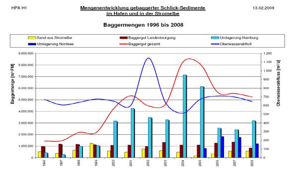
10 Incentive: Dredging hit Maximum in 2004 Development of Dredged Material within the Port and the River Elbe in Hamburg Sand Relocation to North Sea Land Treatment Dredged Material in Sum Relocation in Hamburg Headwater Dredged Material [m 3 ] why? Headwater Discharge [m 3 /s]


11 Estuaries are changing and they are being changed 11

12 Changing Estuary: Land Reclamation and Dykes >> Today 97% without tidal Influence 12

13 Changing Estuary: Tidal Range and Measures 13
14 Changing Estuary: Water Level mthw und mtlw 1900 Water level in 1900 mthw und mtlw 2000 Water level today

15 Changing Estuary: Tidal Pumping 15

16 Changing Estuary: Tidal Pumping Nachteilige Veränderung: Verlandung silting up of anabranches and embankments More sedimentation in Port and fairways Manfred Meine 16
17 Changing Estuary: Sea Level Rise Scenarios Climate Change: sea level rise will increase gradient of Elbe water levels 17

18 Changing Estuary: Headwater Discharge Climate Change: Less Rainfall in Summer? Jan Apr Aug Dec 18


19 Climate Change and Sediment Management + = 19

20 Historical Contamination: Sediment Trap Port of Hamburg Havel Tidal Elbe Zn TBT Hamburg Schwarze Elster Mercury Dresden Sediment Trap Port of Hamburg Saale PCB, HCB Mulde Dioxins/Furans Prag Czech Rep. DDX, PAH 20


21 Fixing the Estuary: The Tidal Elbe Concept Three Cornerstones for a Future Action Plan: 1. Attenuation of the Tidal Energy through River Engineering in the Mouth of the Estuary, 2. More Room for the River (Tidal Volume) in the upper Part 3. Optimisation of the Sedimentmanagement considering the whole System of the Elbe 21
22 3) Sediment Management: Port of Hamburg E L Dewatering Francop METHA Feldhofe JV Dredged Material in m³ (BASSIN) Relocation Land Treatment North Sea E3 Neßsand Land Treatment Sand

23 3) Sediment Management: New Strategy New Old Relocation Scheme


24 3) Sediment Management: Catching Sediments Pilot Measure: Sediment Catchment Basin Monitoring >>
25 3) Sediment Management: source remediation Havel Zn Hamburg Hamburg takes part Schwarze and Elster Mercury sponsors remediation projects in the Dresden Elbe catchment area Saale PCB, HCB Mulde Dioxins/Furans Prag Czech Rep. DDX, PAH 25


26 2) Tidal Volume: Cleaning up the Port 26


27 2) Tidal Volume: Scenarios for Hamburg

28 2) Tidal Volume: Pilot Project Spadenlander Busch ca km 2 former Spoil Area mean surface level +5,50 m NN

29 2) Tidal Volume: Pilot Project Spadenlander Busch


30 2) Tidal Volume: creating Tidal Landscapes 30

31 2) Tidal Volume: Tidal Polder and Storm Surge Relief Future: realized shallow water area at mthw
32 2) Tidal Volume: Tidal Polder and Storm Surge Relief Future: realized shallow water area with lowered polder flap at mthw
33 2) Tidal Volume: Tidal Polder and Storm Surge Relief Future: realized shallow water area with raised polder flap shortly before peak-level
34 2) Tidal Volume: Tidal Polder and Storm Surge Relief Future: realized shallow water area with lowered polder flap at peak level


35 1) Taming the Tide: River Engineering in the Mouth Further investigation / research is needed Soil Sampling idea already incorporated in the present fairway deepening by specific deposition of dredged material in dedicated areas with potential to decrease current velocities Geophysical Tests Drillhole Probing Water Sampling 35


36 1) Future Scenarios for the Mouth today eroding sandbanks STUDIO URBANE LANDSCHAFTEN Ohrt v. Seggern und Partner Im Auftrag von HPA

37 1) Future Scenarios for the Mouth future Stabilisation / nourishment of sandbanks STUDIO URBANE LANDSCHAFTEN Ohrt v. Seggern und Partner Im Auftrag von HPA
38 1) Future Scenarios for the Mouth future Long term development of dams STUDIO URBANE LANDSCHAFTEN Ohrt v. Seggern und Partner Im Auftrag von HPA

39 1) Future Scenarios for the Mouth future Foundation for new dykes Nature Protection STUDIO URBANE LANDSCHAFTEN Ohrt v. Seggern und Partner Im Auftrag von HPA


40 Working Together: Integrated Management Plan Gate to Waddensea Industry PORT Grassland Breeding- and Resting Birds Reed and Alluvial Forest Reed and Alluvial Forest Grassland Habitats City Connectivity PORT Grassland Birds Connectivity Twait Shad, Mudflats Hot Spot of Flora Diversity


41 Working Together: Expert Exchange TIDE

42 Manfred Meine Head of Tidal Elbe Project Hamburg Port Authority Neuer Wandrahm Hamburg Germany manfred.meine@hpa.hamburg.de
Geography of the Lower Fitzroy and navigation problems
 Geography of the Lower Fitzroy and navigation problems A topographic map of the Fitzroy estuary readily indicates why the Fitzroy River has proved difficult for shipping to negotiate. The river meanders
COUPLED MANAGEMENT STRATEGY LAKE CATHIE ESTUARY & COAST
 Lake Cathie Progress Association Inc. ABN 28 251 433 854 P.O. Box 247 Lake Cathie NSW 2445 PHONE/FAX: 02 6584 8211 EMAIL: r3packag@bigpond.com 20 th October 2009 Port Macquarie Hastings Council PO Box
4/06/2014. Need for Guidance. East Coast Lows. Catchment and coastal flood events can combine! Project 18 ARR Review
 Need for Guidance Development of Practical Guidance for Coincidence of Catchment Flooding and Oceanic Inundation Angela Toniato, NSW OEH Duncan McLuckie, NSW OEH Grantley Smith, Water Research Laboratory
Response of a Newly Created Marsh-Wetland Affected by Tidal Forcing, Upland Discharge, and Groundwater Interaction
 Response of a Newly Created Marsh-Wetland Affected by Tidal Forcing, Upland Discharge, and Groundwater Interaction Mouth of Columbia River, Cape Disappointment State Park, Washington 12 Hans R. Moritz
Integrated Waterway Management of the Danube in Austria
 Integrated Waterway Management of the Danube in Austria Thomas Hartl / Senior Expert Waterway Management via donau Österreichische Wasserstraßen-Gesellschaft mbh Vienna, October 14, 2014 Page 3 Figures
EXAMINATION OF CLIMATE CHANGE ADAPTATION STRATEGIES FOR COASTAL PROTECTION. Ralf Kaiser, Heiko Knaack, Marco Miani and Hanz Dieter Niemeyer
 EXAMINATION OF CLIMATE CHANGE ADAPTATION STRATEGIES FOR COASTAL PROTECTION 1 Ralf Kaiser, Heiko Knaack, Marco Miani and Hanz Dieter Niemeyer Climate change adaptation strategies for coastal protection
Request Number IR1-12: Flow Passage. Information Request
 Request Number IR1-12: Flow Passage Information Request Provide additional information about the 100 metre flow passage channel scenario between the Westshore Terminals and the proposed Project terminal
Study of river training measures to overcome inland navigation constraints due to future climate changes
 S. Wurms, P.M. Schroeder www.baw.de Outline Background and project aim The research programme KLIWAS Hydraulic bottlenecks under changing hydrological conditions River training options for adaptation to
APPLICATION OF SHORE PROTECTION SCHEMES IN HORNB^K Mads Peder J0rgensen ' Peer Skaarup 2 Karsten Mangor 3 J0rgen Juhl 4
 APPLICATION OF SHORE PROTECTION SCHEMES IN HORNB^K Mads Peder J0rgensen ' Peer Skaarup 2 Karsten Mangor 3 J0rgen Juhl 4 ABSTRACT Hornbask Harbour was built more than a hundred years ago on a sandy coast
CHAPTER 134 INTRODUCTION
 CHAPTER 134 NEW JETTIES FOR TUNG-KANG FISHING HARBOR, TAIWAN Chi-Fu Su Manager Engineering Department Taiwan Fisheries Consultants, Inc. Taipei, Taiwan INTRODUCTION Tung-Kang Fishing Harbor, which is about
MBMG Butte Mine Flooding Monthly Report BMFOU Consent Decree BU-SEH Remedial Action Monitoring Program Contract No TO-35 September 2013
 MBMG Monthly Report BMFOU Consent Decree 02-35-BU-SEH Remedial Action Monitoring Program Contract No. 400022-TO-35 September 20 The Montana Bureau of Mines and Geology (MBMG) continued to perform monitoring
Feasibility Study for Restoration of Titlow Lagoon Fish Passage. South Puget Sound Salmon Enhancement Group
 Feasibility Study for Restoration of Titlow Lagoon Fish Passage South Puget Sound Salmon Enhancement Group January 2010 Feasibility Study for Restoration of Titlow Lagoon Fish Passage Prepared for South
Coastal Environments Oceanographic and Engineering Expertise
 Coastal Environments Oceanographic and Engineering Expertise Coastal Environments La Jolla, CA www.coastalenvironments.com 14 May 2004 CE Ref. No. 04-05 EcoSystems Management Associates, Inc. Carlsbad,
VIDEO AUDIO Slide 1. Slide 2 Old timey 18 th century map of east coast
 VIDEO AUDIO Slide 1 1A Welcome to the Cooper River Rediversion Project at St. Stephen, Montage of exteriors of facility, South Carolina! Since 1985, this boating, fish runs, fishing, facility has served
SHOREHAM BEACH LOCAL NATURE RESERVE
 SHOREHAM BEACH LOCAL NATURE RESERVE Coastal Geography Education Programme 2014-15 S. Savage 2014 COASTAL GEOGRAPHY OPPORTUNITIES Shoreham Beach Shoreham Beach is a shingle spit formed over many centuries
The Isar -Plan Project in Munich Great (Un) expectations.
 expectations.") The Isar -Plan Project in Great (Un) expectations. European River Restoration Conference Session 5- Enhancement of Multi-Use Landscapes 11-13 September 2013 The Isar-Plan Project: Basic Facts Approximate
The Isar -Plan Project in Great (Un) expectations. European River Restoration Conference Session 5- Enhancement of Multi-Use Landscapes 11-13 September 2013 The Isar-Plan Project: Basic Facts Approximate
1-32 NOME HARBOR, ALASKA (CWIS NOS , 87755, & 10422) Condition of Improvement 30 September 2009
 Condition of Improvement 30 September 2009") NOME HARBOR 1-32 NOME HARBOR, ALASKA (CWIS NOS. 72742, 87755, & 10422) Condition of Improvement 30 September 2009 AUTHORIZATION: (1) Rivers and Harbors Act, 8 August 1917 (House Doc. 1932, 64th Congress,
NOME HARBOR 1-32 NOME HARBOR, ALASKA (CWIS NOS. 72742, 87755, & 10422) Condition of Improvement 30 September 2009 AUTHORIZATION: (1) Rivers and Harbors Act, 8 August 1917 (House Doc. 1932, 64th Congress,
Chapter 10 Lecture Outline. The Restless Oceans
 Chapter 10 Lecture Outline The Restless Oceans Focus Question 10.1 How does the Coriolis effect influence ocean currents? The Ocean s Surface Circulation Ocean currents Masses of water that flow from one
Q1. What are the primary causes/contributors to coastal erosion at Westshore and the concept of longshore / littoral drift.
 Q1. What are the primary causes/contributors to coastal erosion at Westshore and the concept of longshore / littoral drift. In order of (timing related) contribution to present problem 1. Beach is too
NYS Coastal Waters. Water Resources of NYS: THE NATURE of the COASTAL ZONE. NYS Coastal Waters. NYS Coastal Atlas. Coastal Zone Management 10/10/2014
 Water Resources of NYS: THE NATURE of the COASTAL ZONE NYS Coastal Waters NYS is the only state to border the Atlantic Ocean and the Great Lakes (Lakes Erie and Ontario). Great Lakes shoreline: 577 miles
1. Distribute the activity sheet, and allow 20 minutes for the first use.
 A LOCAL WAY OF LEARNING Title: MISSING MANGROVE MESSAGE Author: Eulalie R. Rivera Elementary School Environmental Education Team Grade Level: 4-6 Concepts: 2.Ecosystem 6.Resources 9.Change Disciplines:
Ninilchik Harbor Page 2 of 11
 Ninilchik Harbor Ninilchik Harbor Page 2 of 11 Condition of Improvements 31 December 2017 Ninilchik Harbor, Alaska (CWIS No. 012640, 087345) Authorization Rivers and Harbors Act, 3 July 1958 (P.L. 85-500
VENICE LOCAL COASTAL PROGRAM UPDATE: COASTAL HAZARDS WELCOME
 VENICE LOCAL COASTAL PROGRAM UPDATE: COASTAL HAZARDS WELCOME 1 Introducing the Team Hosted by the Department of City Planning and grant funded in part by the California Coastal Commission 2 Workshop Purpose
Tidally influenced environments. By Alex Tkaczyk, Henrique Menezes, and Isaac Foli
 Tidally influenced environments By Alex Tkaczyk, Henrique Menezes, and Isaac Foli Goals and aims Describe the role of tidal influence in depositional environments. - Deltas - Estuaries Provide an overview
NCCOE EA Coastal Adaptation Guidelines. Section I Emerging Technology Novel Alternative Approaches to Coastal Erosion
 NCCOE EA Coastal Adaptation Guidelines Section I Emerging Technology Novel Alternative Approaches to Coastal Erosion Alessio Mariani, Doug Lord, Tony Webb James Carley, Matt Blacka, Brett Miller Ian Turner,
Sediment Management Plan Rehoboth Bay
 Sediment Management Plan Rehoboth Bay STAC Meeting November 16, 2007 Goals of the Study Improve planning for future dredging needs Reduce the dependency on dredging Study Tasks Environmental data Historical
WODA Technical Guidance on Underwater Sound in Relation to Dredging
 WODA Technical Guidance on Underwater Sound in Relation to Dredging Frank Thomsen, Fabrizio Borsani, Pim de Wit, Douglas Clarke, Christ de Jong, Frederik Goethals, Martine Holtkamp, Gerard van Raalte,
The Masterplan Coastal Safety: a wave of opportunities
 The Masterplan Coastal Safety: a wave of opportunities In depth coastal research and state of the art maritime technology SPINCAM WEEK FLANDERS: OSTEND EVENT FEBRUARY 16-18th 2016 elias.vanquickelborne@mow.vlaanderen.be
As temporary grade control facilities along waterways until final stabilization is established.
 Check Dams (CD) EC-12 Description Check dams are temporary grade control structures placed in drainage channels to limit the erosivity of stormwater by reducing flow velocity. Check dams are typically
Tidal River Management (TRM)-An Innovative Scientific Approach for Sustainable Sediment Management
-An Innovative Scientific Approach for Sustainable Sediment Management") Paper ID: WRE-029 954 International Conference on Recent Innovation in Civil Engineering for Sustainable Development () Department of Civil Engineering DUET - Gazipur, Bangladesh Tidal River Management
Paper ID: WRE-029 954 International Conference on Recent Innovation in Civil Engineering for Sustainable Development () Department of Civil Engineering DUET - Gazipur, Bangladesh Tidal River Management
Deep-water orbital waves
 What happens when waves approach shore? Deep-water orbital waves Fig. 9.16, p. 211 Wave motion is influenced by water depth and shape of the shoreline wave buildup zone surf zone beach Wave base deepwater
1-32 NOME HARBOR, ALASKA (CWIS NOS , 87755, 12270, & 10422) Condition of Improvement 30 September 2012
 Condition of Improvement 30 September 2012") NOME HARBOR 1-32 NOME HARBOR, ALASKA (CWIS NOS. 72742, 87755, 12270, & 10422) Condition of Improvement 30 September 2012 AUTHORIZATION: (1) Rivers and Harbors Act, 8 August 1917 (House Doc. 1932, 64th
NOME HARBOR 1-32 NOME HARBOR, ALASKA (CWIS NOS. 72742, 87755, 12270, & 10422) Condition of Improvement 30 September 2012 AUTHORIZATION: (1) Rivers and Harbors Act, 8 August 1917 (House Doc. 1932, 64th
Marginal Marine Environments
 Marginal Marine Environments Delta: discrete shoreline protuberances formed where rivers enter oceans, semi-enclosed seas, lakes or lagoons and supply sediment more rapidly than it can be redistributed
TheEider. The drama of a river
 TheEider The drama of a river Thelast 600 years Join us on a journey through time! In September 1969 Nis R. Nissen told the story of a river in the magazine "Dithmarschen - Information on local history".
Ennore Coal Port Project: Port Basin and Entrance Channel
 Ennore Coal Port Project: Port Basin and Entrance Channel André Luypaert Ennore Coal Port Project: Port Basin and Entrance Channel Abstract The Chennai Port on the eastern coast of India is the main port
The Sand Motor. Looking back at 2,5 years of building with nature. Anne-Marie Svoboda Rijkswaterstaat Sea and Delta
 The Sand Motor Looking back at 2,5 years of building with nature Anne-Marie Svoboda Sea and Delta Overview RWS and USACE Coastal nourishment strategy Coastal vision The Sand Motor: Design How does it work?
Your web browser (Safari 7) is out of date. For more security, comfort and the best experience on this site: Update your browser Ignore
 is out of date. For more security, comfort and the best experience on this site: Update your browser Ignore") Your web browser (Safari 7) is out of date. For more security, comfort and the best experience on this site: Update your browser Ignore TIDAL BO RE For the complete encyclopedic entry with media resources,
Your web browser (Safari 7) is out of date. For more security, comfort and the best experience on this site: Update your browser Ignore TIDAL BO RE For the complete encyclopedic entry with media resources,
Hydrodynamic and hydrological modelling to support the operation and design of sea ports
 Hydrodynamic and hydrological modelling to support the operation and design of sea ports Data needs and examples Martijn de Jong (port/nautical requirements, waves, currents) Sofia Caires (mean and extreme
Australian Coastal Councils Conference
 Australian Coastal Councils Conference Kiama March 2019 Where Has My Beach Gone? (and what can I do about it?) Dr Andrew McCowan Water Technology Where Has My Beach Gone? Where Has My Beach Gone? Where
EVALUATION OF BEACH EROSION UP-DRIFT OF TIDAL INLETS IN SOUTHWEST AND CENTRAL FLORIDA, USA. Mohamed A. Dabees 1 and Brett D.
 EVALUATION OF BEACH EROSION UP-DRIFT OF TIDAL INLETS IN SOUTHWEST AND CENTRAL FLORIDA, USA Mohamed A. Dabees 1 and Brett D. Moore 1 The paper discusses the analysis of up-drift beach erosion near selected
Figure 1. Schematic illustration of the major environments on Mustang Island.
 STOP #1: PACKERY CHANNEL BEACH TO BAY We will start this field guide near the north jetty of Packery Channel and hike across the island to Corpus Christi Bay (fig. 1). The island emerges from the Gulf
RESEARCH ON ENTRANCE TRAINING AND RECLAMATION PROJECT OF DONGSHUIGANG, CHENGMAI COUNTY, HAINAN
 Proceedings of the 7 th International Conference on Asian and Pacific Coasts (APAC 2013) Bali, Indonesia, September 24-26, 2013 RESEARCH ON ENTRANCE TRAINING AND RECLAMATION PROJECT OF DONGSHUIGANG, CHENGMAI
Isar Plan in Munich,Bavaria Flood Protection, Restoration, Recreation
 Isar Plan in Munich,Bavaria Flood Protection, Restoration, Recreation Dr. Klaus Arzet AGENDA Isar-Plan: history and concept Principle approach and measures: Learning by doing and lessons learnt Conclusions
Beaver in tidal marshes: Dam effects on low-tide channel pools and fish use of estuarine habitat. W. Gregory Hood Skagit River System Cooperative
 Beaver in tidal marshes: Dam effects on low-tide channel pools and fish use of estuarine habitat W. Gregory Hood Skagit River System Cooperative Skagit Historical and Current Deltas 95% loss of tidal
Puget Sound Nearshore Ecosystem Restoration Project Restore America s Estuaries Conference 2012 Tampa, FL
 Restore America s Estuaries Conference 2012 Tampa, FL presented by: Theresa Mitchell, WA Dept. of Fish & Wildlife Nearshore General Investigation Change Analysis: Comparison of historical and current
ELIZABETH RIVER FACTS
 ELIZABETH RIVER FACTS How is she different from inland rivers? The Elizabeth River is an estuary a tidal finger of the Chesapeake Bay, rather than a freshwater river with a spring as origin. The Elizabeth
The Dynamic Coast. Right Place Resources. A presentation about the interaction between the dynamic coast and people
 The Dynamic Coast Houses threatened by coastal erosion in California Right Place Resources A presentation about the interaction between the dynamic coast and people For the rest of the presentations in
CALCASIEU SALINITY STRUCTURES. HYDRODYNAMIC MODELING (To Support Design of Salinity Barriers)
") CALCASIEU SALINITY STRUCTURES HYDRODYNAMIC MODELING (To Support Design of Salinity Barriers) Presentation Overview 1 2 3 4 5 Project Overview and CEA Circulation Modeling Vessel Hydrodynamics Modeling
CALCASIEU SALINITY STRUCTURES HYDRODYNAMIC MODELING (To Support Design of Salinity Barriers) Presentation Overview 1 2 3 4 5 Project Overview and CEA Circulation Modeling Vessel Hydrodynamics Modeling
La Rance tidal power plant in La Rance, France. Tidal and Wave Energy
 La Rance tidal power plant in La Rance, France Tidal and Wave Energy Tides Tides are caused by the pull of the moon. Tides involve the rise and fall of sea levels. Around the coast of Ireland, the sea
MILE POINT TRAINING WALL JACKSONVILLE, FL. Geotextile Tube Installation
 MILE POINT TRAINING WALL JACKSONVILLE, FL Geotextile Tube Installation PROJECT DESIGN Remove portion of existing training wall Construct new eastern and western training walls Deepen new flow improvement
Merkinch Greenspace. Merkinch Local Nature Reserve: Hydrological Assessment
 Merkinch Local Nature Reserve: Hydrological Assessment June 2011 EnviroCentre Craighall Business Park Eagle Street Glasgow G4 9XA t 0141 341 5040 f 0141 341 5045 w www.envirocentre.co.uk e info@envirocentre.co.uk
Modeling changes to the historic Lower Columbia River Estuary using Delft3D. Drew Mahedy Lumas Helaire Stefan Talke David Jay May 30, 2014
 Modeling changes to the historic Lower Columbia River Estuary using Delft3D Drew Mahedy Lumas Helaire Stefan Talke David Jay May 30, 2014 Comparison: Historic and Modern LCRE US Coastal Survey, 1868 Historic
Texas passes, longshore transport, hurricanes, beach erosion and sea level
 Texas passes, longshore transport, hurricanes, beach erosion and sea level Richard L. Watson, Ph.D. (361) 749-4152 Field work can be strange! 120,000 years of sea level Years each zone exposed above S/L
SWANSEA CHANNEL DREDGING TO IMPROVE NAVIGATION
 SWANSEA CHANNEL DREDGING TO IMPROVE NAVIGATION B.Morgan 1, G.Blumberg 1, A.Ling 2, H.Nelson 1 1 Royal HaskoningDHV, Sydney, NSW 2 NSW Department of Trade & Investment (Crown Lands), Newcastle, NSW Overview
EXISTING AND PLANNED STRATEGIES AND ACTIONS CONNECTED WITH COASTAL PROTECTION IN ASPECT OF PREDICTED SEA LEVEL RISE
 EXISTING AND PLANNED STRATEGIES AND ACTIONS CONNECTED WITH COASTAL PROTECTION IN ASPECT OF PREDICTED SEA LEVEL RISE Andrzej Cieślak Long term coastal protection strategy In 2000 a new 1 Polish long term
PODFW Fish Passage Rules and Statutes Frequently Asked Questions
 P 1 PODFW Fish Passage Rules and Statutes Frequently Asked Questions 1. Is fish passage needed for servicing non-stream human constructed canals, ditches, channels? Oregon Fish Passage Statute (ORS 509.580
Tidal Energy from the Severn Estuary: Opportunities and Challenges
 Co-financed with the support of the European Union 1 ERDF Atlantic Area Programme Investing in our common future Tidal Energy from the Severn Estuary: Opportunities and Challenges Prof Roger Falconer,
Climate Change Adaptation and Stream Restoration. Jack Williams;
 Climate Change Adaptation and Stream Restoration Jack Williams; jwilliams@tu.org 1 Goals for this presentation Develop strategies for adapting streams to climate impacts by Thinking like a watershed Understanding
RESTORING 400 ACRES OF TIDAL MARSH IN THE SNOHOMISH RIVER DELTA
 RESTORING 400 ACRES OF TIDAL MARSH IN THE SNOHOMISH RIVER DELTA Marya Moses, Danny Moses, Neil Moses, and Robert Moses fish on Tulalip Bay, near the mouth of the Snohomish River Estuary. QWULOOLT IS A
Vocabulary: Headwaters, watershed, tributaries, estuary, replica, point source pollution, nonpoint source pollution, amd river miles.
 From Source To Sea: Lesson Plan Concepts: 1. Understanding the path the Hudson River takes from the headwaters in the Adirondacks to the New York Harbor 2. Identifying the Hudson River watershed area,
Bay of Fundy Estuary Profile
 s The is a sub-basin of the Bay of Fundy along the northwestern shore of Nova Scotia and at the western end of the Annapolis Valley. The Annapolis River is the major water source flowing into the estuary.
Sediment management plans for the Dutch Rhine branches. Arjan Sieben Rijkswaterstaat Waterdienst
 zurück zum Inhaltsverzeichnis zur Kurzfassung Sediment management plans for the Dutch Rhine branches Arjan Sieben Waterdienst 8 oktober 2009 What happens downstream Lobith? Plans and trends Daily practice
LNG infrastructure in Wilhelmshaven
 LNG infrastructure in Wilhelmshaven 22 nd of November 2018 Agenda 1. Summary of the Study on the LNG terminal location potentials 2. Port of Wilhelmshaven 3. LNG-Terminal in Wilhelmshaven 4. Coordination
Design Assessment Checklist: Infiltration / Detention Basin
 Design Assessment Checklist: Infiltration / Detention Basin Objectives This checklist can be used by the organisation approving the drainage scheme (drainage approving body) to help assess submissions
Water in the Deschutes Who needs it?
 Water in the Deschutes Who needs it? Rivers and streams over appropriation and flow alteration. Junior water right holders production agriculture. The Cities long-term supply for growing populations. Climate
Analysis of Port Phillip Bay Tides Jan 2000 Dec 2009
 Analysis of Port Phillip Bay Tides Jan 2000 Dec 2009 Introduction Many people expressed concern that deepening the shipping channel a further 5 metres at the Entrance to Port Phillip Bay would permanently
Climate Change and Hydrology in the Sierra Nevada. Lorrie Flint U.S. Geological Survey Sacramento CA
 Climate Change and Hydrology in the Sierra Nevada Lorrie Flint U.S. Geological Survey Sacramento CA Discussion Topics Climate change for California Methods to evaluate hydrologic impacts Water balance
The River Feale Catchment
 streamscapes feale The River Feale Catchment www.streamscapes.ie Welcome to thee Water-Cycle! Our River s Journey from Source to Sea The River Feale Catchments Our Wildlife If we can achieve high-quality
Annual Report on Actions Taken Under Implementation Plans. EU Germany
 Agenda Item 7.1 For Information Council CNL(10)28 Annual Report on Actions Taken Under Implementation Plans EU Germany Annual Report on actions taken under Implementation Plan IP(07)21 EU/Germany - for
ST. LOUIS SECTION PROJECT OF THE YEAR AWARD
 ST. LOUIS SECTION PROJECT OF THE YEAR AWARD Originality and Innovation The St. Louis Harbor Project is located in the Upper Mississippi River between the entrance to the Chain of Rocks Canal at River
Cross-shore sediment transports on a cut profile for large scale land reclamations
 Cross-shore sediment transports on a cut profile for large scale land reclamations Martijn Onderwater 1 Dano Roelvink Jan van de Graaff 3 Abstract When building a large scale land reclamation, the safest
Impact of Dredging the Lower Narrow River on Circulation and Flushing
 Impact of Dredging the Lower Narrow River on Circulation and Flushing Craig Swanson Ph.D. Swanson Environmental Alex Shaw Ocean Engineering, URI Prof. Malcolm L. Spaulding Ocean Engineering, URI 29 January
Maryland Chapter Trout Unlimited Brook Trout Conservation Effort
 Maryland Chapter Trout Unlimited Brook Trout Conservation Effort Photo by Matt Kline Portfolio of Recent Work MDTU Brook Trout Conservation Coordinator: Scott C. Scarfone, ASLA sscarfone@oasisdesigngroup.com
City of Del Mar Local Coastal Plan (LCP) Amendment for Sea Level Rise and Coastal Flooding
 Amendment for Sea Level Rise and Coastal Flooding") City of Del Mar Local Coastal Plan (LCP) Amendment for Sea Level Rise and Coastal Flooding 6/22/17 Presentation to Sea Level Rise Stakeholder- Technical Advisory Committee (STAC) Nick Garrity, P.E. Lindsey
City of Del Mar Local Coastal Plan (LCP) Amendment for Sea Level Rise and Coastal Flooding 6/22/17 Presentation to Sea Level Rise Stakeholder- Technical Advisory Committee (STAC) Nick Garrity, P.E. Lindsey
The Effects of Seasonal Stream Dewatering on Bull Trout, Salvelinus confluentus
 The Effects of Seasonal Stream Dewatering on Bull Trout, Salvelinus confluentus Thesis Presentation and Defense By William R. Meyer Central Washington University Introduction Bull trout life history The
Chesil Beach, Dorset UK High energy, shingle coastline. Brighton Beach, Sussex UK Pebble beach
 Beaches: Depositional landform Extends from the highest high tide to the lowest low tide. Very important temporary store in coastal system. Accretion: sediment returning to the visible portion of a beach
An Example of a Unique Partnership for Contaminated Sediment Management The Port Hueneme Experience
 An Example of a Unique Partnership for Contaminated Sediment Management The Port Hueneme Experience AAPA/USACE Quality Partnership Initiative 4 th Annual Project Managers Workshop Port of Ponce, Puerto
SURGE SUPPRESSION ACHIEVED BY DIFFERENT COASTAL SPINE (IKE DIKE) ALIGNMENTS. Bruce A. Ebersole, Thomas W. Richardson and Robert W.
 ALIGNMENTS. Bruce A. Ebersole, Thomas W. Richardson and Robert W.") SURGE SUPPRESSION ACHIEVED BY DIFFERENT COASTAL SPINE (IKE DIKE) ALIGNMENTS Abstract Bruce A. Ebersole, Thomas W. Richardson and Robert W. Whalin, Jackson State University, Jackson, Mississippi The primary
SURGE SUPPRESSION ACHIEVED BY DIFFERENT COASTAL SPINE (IKE DIKE) ALIGNMENTS Abstract Bruce A. Ebersole, Thomas W. Richardson and Robert W. Whalin, Jackson State University, Jackson, Mississippi The primary
Controlling Coastal erosion
 Controlling Coastal erosion Coastal Erosion Rates in the U.S. Coastal Erosion and Stabilization Economic pressures demanding the stabilization of beaches and coastlines are immense Coastal Erosion and
WAVE PROPAGATION DIRECTIONS UNDER REAL SEA STATE CONDITIONS. Joachim Griine 1
 WAVE PROPAGATION DIRECTIONS UNDER REAL SEA STATE CONDITIONS Abstract Joachim Griine 1 This paper deals with the analysis of wave propagation directions from wave climate measurements in field. A simple
Impacts of breakwaters and training walls
 Across the eastern seaboard of Australia, breakwaters and training walls have instigated fundamental perturbations to coastal and estuary processes. This has induced long-term changes to foreshore alignments,
For more information or permission to reprint slides, please contact Donna Milligan at 1
 For more information or permission to reprint slides, please contact Donna Milligan at milligan@vims.edu 1 For more information or permission to reprint slides, please contact Donna Milligan at milligan@vims.edu
Status of the Fairway Rehabilitation and Maintenance Master Plan for the Danube and its navigable tributaries (dated )
") Status of the Fairway Rehabilitation and Maintenance Master Plan for the Danube and its navigable tributaries (dated 23-11-2018) Key achievements since the endorsement of the Master Plan in 2014 The Fairway
Status of the Fairway Rehabilitation and Maintenance Master Plan for the Danube and its navigable tributaries (dated 23-11-2018) Key achievements since the endorsement of the Master Plan in 2014 The Fairway
DEAD-ENDCHANNELFLUSHINGINHARBORS
 DEAD-ENDCHANNELFLUSHNGNHARBORS PURPOSE: The purpose of this technical note is to present some design con- siderations which benefit dead-end channel flushing. Some of these factors can also be used to
Building Coastal Resiliency at Plymouth Long Beach
 Building Coastal Resiliency at Plymouth Long Beach Department of Marine and Environmental Affairs March 30, 2017 Introducing Green Infrastructure for Coastal Resiliency Plymouth Long Beach & Warren s Cove
Shoreline Studies Program, Department of Physical Sciences, VIMS
 Living Shoreline Training Class 2017 1 Demonstration sites discussed in this talk. 2 A shoreline management plan for the entire creek made conceptual shoreline management recommendations along every stretch
STATUS REPORT FOR THE SUBMERGED REEF BALL TM ARTIFICIAL REEF SUBMERGED BREAKWATER BEACH STABILIZATION PROJECT FOR THE GRAND CAYMAN MARRIOTT HOTEL
 August 23 STATUS REPORT FOR THE SUBMERGED REEF BALL TM ARTIFICIAL REEF SUBMERGED BREAKWATER BEACH STABILIZATION PROJECT FOR THE GRAND CAYMAN MARRIOTT HOTEL performed by Lee E. Harris, Ph.D., P.E. Consulting
Estimation of damages caused by storm tides in the city of Hamburg K.-H. Pöschke DHI-WASY GmbH Waltersdorfer Str. 105, Berlin, Germany
 Estimation of damages caused by storm tides in the city of Hamburg K.-H. Pöschke DHI-WASY GmbH Waltersdorfer Str. 105, 12526 Berlin, Germany 1 Introduction The city of Hamburg is potentially endangered
Level 2: River Module
 National Water Safety Management Programme Level 2: River Module Safeguarding lives in, on and near water This resource is the approved material for the RLSS UK s National Water Safety Management Programme
BEACH NOURISHMENT BY RAINBOWING FOR THE VISAKHAPATNAM PORT TRUST BY DCI. Capt. MVR MURTHY ABSTRACT
 BEACH NOURISHMENT BY RAINBOWING FOR THE VISAKHAPATNAM PORT TRUST BY DCI Capt. MVR MURTHY ABSTRACT The coastal city of Visakhapatnam had a long wide beach. Over past three decades, this beach has progressively
page - Laboratory Exercise #5 Shoreline Processes
 page - Laboratory Exercise #5 Shoreline Processes Section A Shoreline Processes: Overview of Waves The ocean s surface is influenced by three types of motion (waves, tides and surface currents). Shorelines
Exeter Flood Defence Scheme
 Exeter Flood Defence Scheme CECA South West Member s Presentation 30th November 2016 Tristan Bassett Commercial Services Manager, EA Don Higgs Framework Manager, BMM JV Update Covering.. Why we re Building
RI Regulatory Setbacks & Buffers: Coastal Management Issues
 RI Regulatory Setbacks & Buffers: Coastal Management Issues New England Onsite Wastewater Training Program @ URI OWT 155 - November 29, 2012 James Boyd - Coastal Policy Analyst Photo: October 30, 2012
Coastal Inundation. An Overview for TCDC
 Coastal Inundation An Overview for TCDC Rick Liefting Team Leader Regional Hazards and Environmental Compliance Integrated Catchment Management Waikato Regional Council Photo: Sugar Loaf Wharf, Coromandel.
County of Santa Barbara Permit Option Analysis Goleta Beach JULY 13, 2017
 County of Santa Barbara Permit Option Analysis Goleta Beach JULY 13, 2017 Introduction 2 Goleta Beach Park welcomes 1.5 million visitors annually Amenities include: Picnic Areas and Group Areas w/bbqs
APPENDIX C. Fluvial and Tidal Hydraulics Report
 APPENDIX C Fluvial and Tidal Hydraulics Report BUENA VISTA LAGOON ENHANCEMENT PROJECT FLUVIAL AND TIDAL HYDRAULICS ANALYSES Prepared for: SANDAG 401 B Street, Suite 800 San Diego, California 92101 Contact:
CATCHMENT HYDROLOGICAL RESPONSE TO CHANGING LAND SYSTEM IN KASHMIR HIMALAYA
 IGC, 2012 28 August, 2012 CATCHMENT HYDROLOGICAL RESPONSE TO CHANGING LAND SYSTEM IN KASHMIR HIMALAYA Prof. SHAKIL A ROMSHOO HEAD, DEPT OF EARTH SCIENCES KASHMIR UNIVERSITY PRESENTATION OVERVIEW KASHMIR
What happens to Oregon s tidal wetlands with sea level rise?
 What happens to Oregon s tidal wetlands with sea level rise? Laura Brophy Estuary Technical Group Institute for Applied Ecology Corvallis, OR Laura@appliedeco.org Project maps future tidal wetlands, predicts
Feasibility Study for Dredging of Khaprabhanga Chapalir Don River in Patuakhali District for Improvement of Navigability
 IOSR Journal of Engineering (IOSRJEN) ISSN (e): 2250-3021, ISSN (p): 2278-8719 Vol. 04, Issue 06 (June. 2014), V3 PP 32-38 www.iosrjen.org Feasibility Study for Dredging of Khaprabhanga Chapalir Don River
Puget Sound Shorelines. Waves and coastal processes. Puget Sound shorelines: Effects of beach armoring
 Puget Sound Shorelines Puget Sound shorelines: Effects of beach armoring Waves and coastal processes Factors affecting wave energy hitting the coast Processes transporting sediment along coastlines What