Kayak Navigation for Normal People Tim Mattson,
|
|
|
- Milton Harper
- 5 years ago
- Views:
Transcription

1 Kayak Navigation for Normal People Tim Mattson, Deception pass chart provided by Don Beale Photo by Jodi Wright
2 The Essence of Kayak Navigation A kayaker at ANY point should be able to answer the following questions 1. Where are we? 2. How are we moving (direction and speed)? 3. When will we get there? 4. What risks are we taking? Kayak navigation is the set of skills required to answer those 4 questions.
3 GPS Advantages: Easy to use. Accurate even with restricted visibility GPS Problems: Electronics can fail a marine environment is hard on electronics Batteries have limited lifespans and seem to fail when you need them most. Why not just use a GPS It fundamentally comes down to Aesthetics we paddle to immerse ourselves in nature. So why navigate with your nose in a tiny LCD screen? A GPS is a great back-up for limited visibility emergencies. Leave it in your day hatch.
4 The Practice of Navigation Orientation Locations and Directions Moving consciously across the water Dealing with the environment
5 Orientation in the marine world Home based orientation know the direction towards home at all times. Great for your home waters. Not practical for long distance journeys or navigation in unfamiliar waters. Figure 18 from David Lewis, We the Navigators

6 Orientation in the Marine World Chart based orientation I know where my home is relative to a chart, and I know where I am relative to features on the chart.

7 Earth s Coordinate System Latitude Longitude Equally spaced lines North to South Closer together east to west as you approach the poles
8 1 minute of latitude = 1 nautical mile Reading a Nautical Chart Soundings (depths) from chart datum the mean lower low tide (when in doubt, check the chart legend). NOAA tide tables use the same datum.
 8 8 7? 3 3 rk (5) Always water (white or blue)?")
9 Charted depths and elevations 20 feet Charted depth (assume 7 ft in this case) 5 Reference elevation for objects that stay dry mean High tide Typical NOAA Chart Datum. Used for depths. Defines zero on NOAA tide tables Uncovers (green) 8 8 7? 3 3 rk (5) Always water (white or blue)? 2 (2) Lower low tide (0) Always dry (yellow or tan) Based on Burch figure 2-6
10 Reading a Nautical Chart Cliffs Training wall (partially submerged at high water) Fixed Red light 186 ft above mean high tide Training wall (always dry) Alternating White/Red light, 30 sec period 220 ft above mean high tide and visible from 18 miles away Green square shaped beacon with the number 7 Flashing Green Light 4 sec period on a tower 15 ft above mean high tide and visible from three miles with the number 1 on it ( Ra Ref = Radar reflector) Meaning of symbols from Chart No. 1

.")
11 Aids to navigation: Channel Buoys Port side: odd numbered aids When heading into port (In North America) Red Return Right Starboard side: even numbered aids Light 1 Fl G 6s Lighted Buoy G 9 Fl G 4s Light 2 Fl R 6s R 8 Fl R 4s Lighted Buoy G C 9 G 5 R N 5 R 2 Can Day Beacon Source: US Coast Guard Light List, Nun Day Beacon Aids to Navigation: A mark or object outside the boat to support navigation (e.g. buoy). Navigational Aids: A tool used :inside the boat to support the navigator (e.g. compass)
12 Learning about the symbols on a chart Chart 1 defines the full set of symbols found on a nautical chart Chart 1 It s free


13 Navigating by chart alone can be tough Connecting what you see with what s on the chart can be hard. The picture below is what you d see if you were sitting in the red kayak on the chart. Source: Photo and Chart from Pat Welle


14 Navigating by chart alone can be tough Connecting what you see with what s on the chart can be hard. Source: Photo and Chart from Tim Mattson This picture is what you d see if you were sitting in the red kayak on the chart


15 Navigating by chart alone can be tough Connecting what you see with what s on the chart can be hard. The picture below is what you d see if you were sitting in the red kayak on the chart. Jen Rahn off Cape Foulweather Oregon, picture by Tim Mattson and Kathleen Mattson
16 The Practice of Navigation Orientation Locations and Directions Moving consciously across the water Dealing with the environment


17 Finding directions and fixing locations When a chart is not enough you need help fixing your location. When visibility is restricted or a crossing is too far to eyeball navigable features you need help fixing your direction. When the going gets touch, you need a compass store.silva.com.cust.shopatron.com/products/345156/ranger_cl 515_Compass


18 Earth s magnetic field and the compass Compass: a magnet that aligns with the earth s magnetic field points to magnetic north. Spin Axis Magnetic Field lines Magnetic Axis
19 Compass basics: parts and usage Compass needle Orienting arrow Direction of travel-arrow The parts of a hand held compass Orienting lines Compass dial (housing) If you want to face Northwest, (1) rotate the compass dial to point Northwest (2) hold the compass flat and square to your body. (3) rotate yourself (keeping compass flat and square to your body) until North on the orienting arrow lines up with the red compass needle.
20 Compass jargon Basic terms: bearing, heading, course, and line of position Current or wind Towers A Poorly drawn buoy Deviation: the difference between an accurate and the observed magnetic bearing due to man made compass interference. For example, a large metal object packed beneath a deck compass will cause a deviation.
 is called variation on sea or declination on land.")
21 Location of the North Pole Magnetic North Pole 2001 Magnetic North is different than true north pole. The Angular difference between true and magnetic poles ( ) is called variation on sea or declination on land. Note that the north pole is actually a south pole since the field lines go into the earth at this point but its traditionally been called the north pole and the name has stuck.
 Longitude ( W) 2001 81.3 110.8 2002 81.6 111.6 2003 82.0 112.4 2004 82.3 113.4 2005 82.7 114.4 Path of Pole movement since its discovery in 1831 http://gsc.nrcan.gc.")
22 North Pole Movement (secular variation) The North Pole is drifting at about 25 miles per year the rate of drift seems to be increasing. It could be in Siberia in 50 years! Year Latitude ( N) Longitude ( W) Path of Pole movement since its discovery in
23 Connecting the compass to a nautical chart: The compass rose You read Inner ring: magnetic Outer ring: true magnetic bearings from your compass You read true bearings form the longitude lines on the chart. The compass rose reports the difference between true and magnetic north this is called the variation.
24 Using Bearings from a chart You are at John s pass and want a compass bearing to the tip of Waldron island 1. Draw a line from John s pass to the tip of Waldron island 2. Put compass along that line
25 Using Bearings from a chart You are at John s pass and want a compass bearing to the tip of Waldron island 1. Draw a line from John s pass to the tip of Waldron island 4. Read the bearing off the compass. This is a true bearing (52 deg). 2. Put compass along that line 3. Rotate the dial until the orienting lines line up with the longitude lines (north south lines)
 add variation.")
26 Using Bearings from a chart You are at John s pass and want a compass bearing to the tip of Waldron island You need a magnetic bearing to take a bearing in the real world. Memorize the formula to modify true bearing with the variation to produce the magnetic bearing. In the west U.S. Put compass onto chart, (mag. to true) add variation. Take compass off the chart (true to mag.), subtract variation 52 deg 18 deg = 35 deg. Or just use the compass rose as a conversion table just read off the rose that 52 true equals 34 magnetic
27 Triangulation to fix your position. Take your bearing to two known points on a chart. Draw the lines to fix your location.
28 The Practice of Navigation Orientation Locations and Directions Moving consciously across the water Dealing with the environment
29 Moving consciously across the water As you move across the water, you need to know where you are from one moment to the next. You need to move across the water in a well defined and controlled way. You need to know how you are moving at any moment. Two key methods: Piloting using landmarks and other features Dead reckoning deducing motion based on time and velocity

30 Piloting navigating by traveling from one known feature to the next. Combine a set of features to define a route to your destination The key to piloting is to always keep track of where you are with respect to features on your chart. Piloting Use triangulation from time to time to verify your position. Use ranges underway to gauge progress relative to known features. Piloting is straight forward if you pay attention and continuously gauge your location relative to key landmarks.
31 Ranges and detecting motion off-shore Ranges: a pair of objects lined up to define a line of position. Pick two well separated objects. The motion of the rear object shows your motion. Current or wind Use Ranges to make sure you are making progress Towers A Poorly drawn buoy
32 Dead Reckoning Dead Reckoning deducing your position over time based on your velocity and the elapsed time: Requires accurate idea of your paddling speed and environmental forces that impact your speed (current, wind, etc.). When do we use Dead Reckoning: when there are no landmarks or when there is reduced visibility. to keep track of progress between chart features when piloting.
33 Dead Reckoning Example Paddling at a three knot pace against 1 knot of current for 30 minutes. How far have you traveled? (3 nm/hr 1 nm/hr) * (1/2 hr) = 1 nm To use Dead Reckoning correctly, you must develop a feel for your paddling speed and pay close attention to the currents around you. Nm nautical Mile, hr hour
34 The Practice of Navigation Orientation Locations and Directions Moving consciously across the water Dealing with the environment Current Weather Tides

35 Current and wind Current (and wind) can push you off course. Warren Williamson at deception pass in 50+ knots of wind and 6 knots of current. Photo by Pam Powell taken from the deception pass bridge. Source: Sterling's kayaks web page. You must learn how to plan around current Paddling with current can be fun. Paddling against the current can be difficult, stupid or even dangerous. Current squeezing through obstructions and over submerged shelves forms rough water called a tide race.
36 0 1 2 Nautical miles Crossing in Current (Rosario Strait) Crossing from tide point to Obstruction pass with a fixed compass heading Obstruction Pass Tide Pt. Current
37 Crossing in Current (fixed heading) Crossing from tide point to Obstruction pass with a fixed compass heading Obstruction Pass Sum of current and kayak motion Tide Pt Nautical miles A fixed heading in current puts you past your goal
38 Crossing in Current (always pointing at your goal) Crossing from tide point to obstruction pass while pointing at your goal Obstruction Pass Tide Pt Nautical miles Once again, the current puts you puts you past your goal
39 0 1 2 Nautical miles Crossing in Current (Compensate for current) How do you safely navigate a crossing when current (or high wind) are pushing you past your goal?. Let s consider a specific example You are leading a group from Tide Pt. to Obstruction pass during peak flood 2.5 knot current Obstruction Pass The group is experienced, can hold a 3 knot pace for an hour Should you do the crossing now? Tide Pt.
40 0 1 2 Nautical miles Obstruction Pass Crossing in Current (Compensate for current) You are leading a group from Tide Pt. to Obstruction pass during peak flood 2.5 knot current The group is experienced, can hold a 3 knot pace for an hour Should you do the crossing now? Tide Pt. First step figure out what the current would do to a direct path across the channel
41 Crossing in Current (Compensate for current) You are leading a group from Tide Pt. to Obstruction pass during peak flood 2.5 knot current Obstruction Pass 5/6 2.5 knots 2 1/12 nm Resultant path The group is experienced, can hold a 3 knot pace for an hour Should you do the crossing now? 2.5 nm, 5/6 3 knots 1. Draw line for path with no current measure distance (2.5 nm) and compute zero current crossing time (5/6 hr). 2. Use that time and current speed to find vector for how far current will push you. Tide Pt. So now you know just how far the current will push you off course. 3. Add them together to get route Nautical miles
. Tide Pt.")
42 Crossing in Current (Get high. Stay high) Solution: you have two options: 1. Don t cross now. Wait for less current 2. Go now, but get high and stay high Obstruction Pass Get high i.e. head upstream before starting across. Stay high plan to arrive upstream of your target (note: we use the same technique with high winds). Tide Pt. Slide triangle down to guestimate how high to get before crossing Nautical miles Current weakest along shore even in powerful current, you can usually make progress if you hug the shore
43 Ranges and ferry angles Ferry modify your heading to face into current or wind to offset its effect on your course. Use ranges to set and verify your Ferry angle Current Adjust Ferry angle to keep these object in line Towers Ferry Angle A Poorly drawn buoy
, Aug. 2010. Video by Sterling Donaldson.")
44 Current Hazards tide races Tim Mattson at Sechelt Narrows, B.C. (Skookumchuck), Aug Video by Sterling Donaldson.
45 Working with Forecasts You must look up currents before you go on a trip so you can plan around them. Remember: most paddlers can only hold a 3 knot pace over long distances so any current approaching 3 knots or more can get you into deep trouble! weather and swell tide height current information
46 Current Definitions Set of the current the direction towards which the current is flowing. E.g. A current flowing from the north to the south is called a southerly current. Notice that this is opposite to the convention with wind for which direction indicates where it is blowing from. Drift of the current its speed in knots. Flood the current that occurs when the water flows from the sea towards shore and increases the level of the tide. Ebb a current that occurs when water flows from shore towards sea and the level of the tide decreases. Slack the state of relative calm when the current changes from an Ebb to a Flood or visa versa. Notice: the more precise term now used on current forecasts is minimum before flood or minimum before ebb since in many cases the water never stops moving.

47 NOAA current entry page

48 Current Regions in Oregon and Washington

49 Columbia river current stations There are so many of them I focus on the worst case scenario and pick the station with the greatest current swings

50 Sand Island, 1nm SE of (midchannel)
 90% of peak after 1 st segment 50% of peak after 2 nd segment 0% (slack) after")
51 The 50/90 rule The NOAA tables provide times for slack and peak. Use the 50/90 rule to estimate current at other times: Divide time from peak to slack into three equal segments (~1 hr) 90% of peak after 1 st segment 50% of peak after 2 nd segment 0% (slack) after 3 rd segment Reverse process back to peak 50% of peak after 1 st segment 90% of peak after 2 nd segment 100% (peak) after 3 rd segment This rule interpolates abs(cos(n*pi/12)) for n = 0 to 12. it comes from David Burch, Fundamentals of kayak Navigation, 1987
52 Weather Dealing with weather is simple always check forecasts and know your limits. It s the wind that matters most. Key issues for understanding wind: Direction: Stated in terms of where the wind comes from (opposite of the convention with current). Fetch: the span of water the wind blows over. Time: How long has the wind been blowing? Anything over 25 knots is very tough! Only advanced paddlers working in well practiced teams should choose to paddle beyond 30 knots and even then, you better hope you re heading downwind!

53 Weather underground.. Ilwaco WA Oct 16, Select a city near your coastal destination Click marine forecast button

54 Marine Forecast, Ilwaco WA Oct 16, 2009 Buoy data to see current action off-shore Columbia Bar forecast is most relevant for Ilwaco, WA Scroll down for more forecast options

55 Marine forecast options OR/WA coasts Columbia Bar is nice, but you need to know what s happening further out so you can anticipate how things will change over the course of the day.


56 Marine forecast Oct. 16, 2009 cascade head to cape shoalwater westward 20 nm This is bad you should probably stay on shore

57 Tides come from oceans bulges due to gravitational forces from the sun and the moon. Biggest bulges when the sun, earth and moon are lined up Origins of tides Sun Animation from Diederik Willemsen,
58 Spring and Neap Tides Neap Tide: moon 90º from sun/earth axis Spring Tide: moon in line with sun/earth axis half moon Full and new moon ~ seven days Figure from Diederik Willemsen,
 Semidiurnal tide: two highs, two lows per tidal day. Roughly equal magnitude (e.g. Boston, MA) Mixed: wide variation in highs and lows with longer tidal cycles than a diurnal tide (e.")
59 3 Types of Tides Tides depend on many factors: Shape of the water basin Frictional forces Coriollis effect Weather Diurnal: one high and one low (e.g. Corpus Cristi, TX) Semidiurnal tide: two highs, two lows per tidal day. Roughly equal magnitude (e.g. Boston, MA) Mixed: wide variation in highs and lows with longer tidal cycles than a diurnal tide (e.g. Tacoma, WA).

60 NOAA tide web page Click the link for your state (Washington in this case)

61 Washington/Oregon tide stations Choose your region of interest (Columbia River)

62 Tide Stations along Columbia river Select a tide station (Fort Canby, Jetty A ) Note you need to know a bit about the area to figure out which tide stations to select.
")
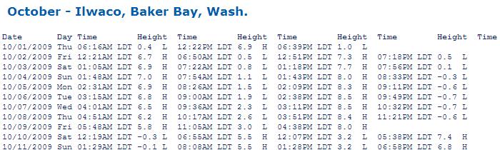
63 Baker Bay (a-jetty) tides
64 Tidal variation from day to day Basic facts: Earth rotates once per 24 hours. Moon orbits earth in 28 days. Moon position at same time from one day to another When you finish a full rotation, the moon has moved 1/28 of an orbit ahead of the previous day s position Impact on tide: Tidal bulge follows the moon s position. Hence tide moves forward by 1/28 th of a cycle or Tide is shifted 24/28 * 60 = 51 minutes later. Earth moon Day 1 moon Day 2
65 Spring Neap Spring Neap Spring Estimating tidal variation from day to day Rule of sevenths moon earth earth moon moon moon earth earth moon earth Full moon Half moon New moon Half moon Full moon sun sun sun sun sun 7 days 7 days 7 days 7 days 7 days from spring to neap. Assume a linear variation, i.e.: Each day tidal range changes by 1/7 spring/neap change. Example: Spring range 12 feet Neap range 6 feet 3 days after full moon, tidal range will be: 12 3*(12-6)/7 = 9.4 feet
66 Estimating Tides: The rule of 12 th s Tide varies from low to high (and back again) according to a smooth curve called a sine wave. The rule of 12 th s approximates a quarter sine wave Divide time from low to high tide into six segments (~ one hour segments). The change after each segment (hour) expressed as a fraction of 12: First hour 1/12 High tide Second hour +2/12 Third hour +3/12 Fourth hour +3/12 Fifth hour +2/12 Sixth hour +1/12 Low tide
67 Summary You should always know: 1. Where are we? 2. How are we moving (direction and speed)? 3. When will we get there? 4. What risks are we taking? Kayak Navigation: the tools to answer those questions: Orientation Locations and Directions Moving consciously across the water Dealing with the environment
68 Next Steps You can not learn navigation by listening to a lecture. You must go out and practice. Get a chart for local waters you enjoy make sure its big open waters with lots of interesting features. Study the chart with a copy of chart 1 in hand and learn the symbols. Get a compass and play with it until its use is second nature. Setting and holding a heading Moving between true and magnetic bearings Triangulation Routinely track weather, current, and tide forecasts for interesting areas get familiar with the jargon


69 References Chart 1 all the symbols found on a NOAA nautical chart. PDF available online from NOAA. David Burch s classic reference book on kayak navigation We the navigators by David Lewis A study of the greatest navigators in human history How to read a nautical chart. Annotated Chart 1 for U.S. and Canada plus fascinating background on Charts
Lat. & Long. Review. Angular distance N or S of equator Equator = 0º Must indicate N or S North pole = 90º N
 Navigation Part 2 1 Lesson Objectives Understand how a ships compass works and how it is used for navigation Measure distances on nautical charts Plot a course on a nautical chart Correct course headings
Chartwork Learn the basics for position fixing using a number of techniques and a simple equation for speed, distance and time.
 Chartwork Learn the basics for position fixing using a number of techniques and a simple equation for speed, distance and time. Chartwork Chartwork Tools Accurate chart work is the basis for good navigation.
Nautical Navigation: Final Quiz
 Name: Nautical Navigation Final Quiz Class: (ver. 03/09/15) Date: Page 1 of 9 Nautical Navigation: Final Quiz There are three sections: Multiple Choice, True/False, and Short Answer. For the multiple choice,
Navigate in difficult or trackless areas
 Description This unit covers the knowledge and skills in off-road navigation in untracked areas in situations where extreme environmental conditions and/or poor visibility are not likely to occur. Objectives
Basic Chartwork. Necessary Tools. Navigation is the one science in which no margin whatever is left for the faker. - Felix Riesenberg
 Page 1 of 14 www.bananawind.us Navigation is the one science in which no margin whatever is left for the faker. - Felix Riesenberg Basic Chartwork You wouldn't want to attempt open ocean sailing using
13. TIDES Tidal waters
 Water levels vary in tidal and non-tidal waters: sailors should be aware that the depths shown on the charts do not always represent the actual amount of water under the boat. 13.1 Tidal waters In tidal
Navigation & Orienteering: Pre- Test
 Name: Class: Answer Key Date: Page 1 of 7 Navigation & Orienteering: Pre- Test There are three sections: Multiple Choice, True/False, and Short Answer. For the multiple choice, please select the BEST answer
CALCULATING IN-FLIGHT WINDS
 CALCULATING IN-FLIGHT WINDS SITUATION: The TH of your aircraft is 350 with the TAS of 150 kts. GS has been determined to be 160 kts, and the Track is 355. What is the wind? ESTIMATE! First compare TAS
SURFACE CURRENTS AND TIDES
 NAME SURFACE CURRENTS AND TIDES I. Origin of surface currents Surface currents arise due to the interaction of the prevailing wis a the ocean surface. Hence the surface wi pattern (Figure 1) plays a key
COXSWAIN NAVIGATION EXERCISES AUS197 NAME:
 COXSWAIN NAVIGATION EXERCISES AUS197 NAME: A deviation card is supplied at the end of this file. Check the answers Question 1 Using any chart (or use the AUS 197 extract) to: 1. Identify a distance of
2005 ABC. Chapter 3 Part 2. Navigating with ATON's. Revision to D-13 Local Notes. Instructor Notes for Mike Brough. Mike Brough
 2005 ABC Chapter 3 Part 2 Navigating with ATON's Revision to D-13 Local Notes Instructor Notes for Mike Brough Mike Brough June 24 2008 June 24 2008 Slide 1 June 24 2008 New graphics Navigating on Water
Anchoring Is Important
 BCC Sailing Classes - Third Theory Anchoring Anchoring Is Important 1 The Anchor is your last resort. Anchoring Keep off a lee shore. Needs to be shaped (type of anchor) to bury in the type of bottom for
OPERATIONS SEAFARER CERTIFICATION GUIDANCE NOTE SA MARITIME QUALIFICATIONS CODE. Deck: Chart Work
 Page 1 of 6 Compiled by Approved by Chief Examiner Syllabus Committee: 26 February 2013 OPERATIONS SEAFARER CERTIFICATION GUIDANCE NOTE SA MARITIME QUALIFICATIONS CODE Deck: Chart Work Page 2 of 6 COLUMN
Tidal Planning for Sea Kayakers
 Tidal Planning for Sea Kayakers There is almost a reputation around tidal planning that it is a black art. Well, this handout aims to remove that notion and ensure that the important link is made between
Land Survey. 1. Pick the two points (A and B) that you would like to measure. You must be able to see clearly between the two points.
 that you would like to measure. You must be able to see clearly between the two points.") Land Survey William Clark did most of the surveying and mapping for the Lewis and Clark Expedition. When he needed to measure the distance between two points that were far apart, he used a method called
Land Survey William Clark did most of the surveying and mapping for the Lewis and Clark Expedition. When he needed to measure the distance between two points that were far apart, he used a method called
Sailing Blind: The Challenges of a Submarine's Navigator
 Sailing Blind: The Challenges of a Submarine's Navigator John Clark, Physics Teacher and Military Historian, Deltona HS, Deltona 2012 Naval Historical Foundation STEM-H Teacher Fellowship Instructional
Well, Well, Well. BACKGROUND Seasonal upwelling is a very important process in the coastal ocean of the Pacific Northwest.
 Well, Well, Well SUMMARY In this activity students investigate the relationship between winds, surface currents, sea surface temperature and upwelling and downwelling off the coast of OR and WA. Students
Navigation Using Compass
 Navigation Using Compass Updated January 2015 Albi Sole 0 Outdoor Council of Canada / Conseil canadien de plein air Published by The Outdoor Council of Canada / Conseil canadien de plein air KNA-101, 2500
Chart Features Maritime maps and Admiralty charts have these features:
 Introduction to Charts A chart or map of the area is an important safety item to carry on board. It allows the Master to obtain knowledge of the area to be travelled, and indicates the navigable channels
Overview and preview. I. Tides as Waves (really really big) What are the Forces driving these waves? II: Into make-believe.
 What are the Forces driving these waves? II: Into make-believe.") The Tides Overview and preview I. Tides as Waves (really really big) What are the Forces driving these waves? II: Into make-believe. Idealized world: no land, deep water, no friction.no problems. Effects
The Tides Overview and preview I. Tides as Waves (really really big) What are the Forces driving these waves? II: Into make-believe. Idealized world: no land, deep water, no friction.no problems. Effects
Equilibrium Model of Tides
 Tides Outline Equilibrium Theory of Tides diurnal, semidiurnal and mixed semidiurnal tides spring and neap tides Dynamic Theory of Tides rotary tidal motion larger tidal ranges in coastal versus open-ocean
WORKBOOK NAVIGATION Tr. For Power-driven and Sailing Vessels DAVID BURCH LARRY BRANDT
 Piloting Dead reckoning Special publications Lights and buoys Electronic fixes Chart reading and plotting Compass use Navigation Rules Tides and currents Depth sounding navigation STARPATH This book provides
Theory and Application Introductory Oceanography Ray Rector: Instructor
 OCEAN TIDES Theory and Application Introductory Oceanography Ray Rector: Instructor Tidal Concepts Tides are extremely swift, very long-wavelength, shallow-water waves Tides are periodic short-term changes
Navigation with Leeway
 Navigation with Leeway Leeway, as we shall use the term, means how much a vessel is pushed downwind of its intended course when navigating in the presence of wind. To varying extents, knowledge of this
TIDES. Theory and Application
 TIDES Theory and Application Tidal Concepts Tides are extremely swift, very long-wavelength, shallow-water waves Tides are periodic short-term changes in sea level at a particular place caused by the gravitational
AUS small scale charts for coastal navigation. Scale: 1 to 150,000
 CHART-WORK SCALE Charts are available in different scales depending on their use. For passage planning you would use small scale charts and for close quarter manoeuvring you would use larger scale charts
Nautical Chart Challenge
 Discover Your World With NOAA Nautical Chart Challenge For as long as anyone in his family could remember, Francis Beaufort wanted to make scientific observations from the deck of a ship. In 1789 at the
OCN 201 Tides. Tsunamis, Tides and other long waves
 OCN 201 Tides Tsunamis, Tides and other long waves Storm surges Caused by winds and low atmospheric pressure associated with large storms Can raise sea surface by up to 25 ft, bottom contours magnify effect
National Maritime Center
 National Maritime Center Providing Credentials to Mariners (Sample Examination) Page 1 of 13 Choose the best answer to the following Multiple Choice Questions. 1. What is the approximate geographic range
Chapter 11 Tides. A tidal bore is formed when a tide arrives to an enclosed river mouth. This is a forced wave that breaks.
 Chapter 11 Tides A tidal bore is formed when a tide arrives to an enclosed river mouth. This is a forced wave that breaks. Tidal range can be very large Tide - rhythmic oscillation of the ocean surface
PART 5 - OPTIONS CONTENTS 5.1 SYSTEM EXPANSION 5-3
 PART 5 - OPTIONS CONTENTS Para Page 5.1 SYSTEM EXPANSION 5-3 5.2 SENSORS 5-3 5.2.1 Trim Angle Sensor 5-3 5.2.2 Mast Rotation Sensor 5-3 5.2.3 Heel Angle Sensor 5-3 5.2.4 Barometric Pressure Sensor 5-3
Terrestrial Observations Chart Plot - Chesapeake Bay Entrance - Operational Level
 USCG 00326-NP-5 The following questions are based on chart 12221TR, Chesapeake Bay Entrance, and the supporting publications. The draft of your tow is 27 feet (8.2 meters). Use 10 W variation where required.
Appendix 5: Currents in Minas Basin. (Oceans Ltd. 2009)
") Appendix 5: Currents in Minas Basin (Oceans Ltd. 29) Current in Minas Basin May 1, 28 March 29, 29 Submitted To: Minas Basin Pulp and Power P.O. Box 41 53 Prince Street Hansport, NS, BP 1P by 22, Purdy
Appendix 5: Currents in Minas Basin (Oceans Ltd. 29) Current in Minas Basin May 1, 28 March 29, 29 Submitted To: Minas Basin Pulp and Power P.O. Box 41 53 Prince Street Hansport, NS, BP 1P by 22, Purdy
LX Compass module 3 Electronic compass device User manual
 LX Compass module 3 Electronic compass device User manual LX navigation d.o.o., Tkalska 10 SLO 3000 Celje, tel: + 386 3 490 46 70, fax: + 386 3 490 46 71 info@lxnavigation.si, http://www.lxnavigation.com
National Maritime Center
 National Maritime Center Providing Credentials to Mariners (Sample Examination) Page 1 of 16 Choose the best answer to the following Multiple Choice Questions. 1. On U.S. charts, you can tell if a named
Chapter 10 Lecture Outline. The Restless Oceans
 Chapter 10 Lecture Outline The Restless Oceans Focus Question 10.1 How does the Coriolis effect influence ocean currents? The Ocean s Surface Circulation Ocean currents Masses of water that flow from one
Lesson 2: Sailing. A league is three nautical miles. (A nautical mile is about 800 feet longer than a mile on land.)
") Early Explorers -> 2: Sailing Lesson 2: Sailing Getting Started? Big Ideas What methods did sailors have for survival on the seas? & Facts and Definitions 8 Skills " Materials Introduction Navigation is
Early Explorers -> 2: Sailing Lesson 2: Sailing Getting Started? Big Ideas What methods did sailors have for survival on the seas? & Facts and Definitions 8 Skills " Materials Introduction Navigation is
3 Maps and Charts In order to navigate we need to use some form of map. The two choices are nautical charts, or land maps.
 13 3 Maps and Charts In order to navigate we need to use some form of map. The two choices are nautical charts, or land maps. Charts Nautical Charts only show the land detail that is visible from the sea.
page - Laboratory Exercise #5 Shoreline Processes
 page - Laboratory Exercise #5 Shoreline Processes Section A Shoreline Processes: Overview of Waves The ocean s surface is influenced by three types of motion (waves, tides and surface currents). Shorelines
28 Navigation Reminders Coastal Navigation by John C. Kelly, 2003
 28 Navigation Reminders Coastal Navigation by John C. Kelly, 2003 CRITICAL REMINDERS 1. Measure distance from latitude scales. 2. Take all bearings in degrees magnetic. 3. Always verify depth: surface
Chapter 22, Section 1 - Ocean Currents. Section Objectives
 Chapter 22, Section 1 - Ocean Currents Section Objectives Intro Surface Currents Factors Affecting Ocean Currents Global Wind Belts (you should draw and label a diagram of the global wind belts) The Coriolis
Letter Latitude Longitude A B C D E F G
 Co-ordinates Problem Using your dividers and the chartlet on the following page complete this table. Letter Latitude Longitude A B C D E F G Nautical Charts Review. Questions 1. A Mercator projection
MAR 110 LECTURE #16 Tides
 MAR 110: Lecture 16 Outline Tides 1 MAR 110 LECTURE #16 Tides Tides Are Waves Tidal wave energy is concentrated at periods of approximately 12 and 24 hours. (ItO) Equilibrium Tidal Forcing The theoretical
INTRODUCTION TO NETWORK WIND 3 MOUNTING THE UNIT 14 SELECTING THE DISPLAY MODE 5 ABBREVIATIONS AND DEFINITIONS 17
 CONTENTS CONTENTS 1 INSTALLATION 14 GENERAL INTRODUCTION TO B&G NETWORK 2 SITING THE UNIT 14 INTRODUCTION TO NETWORK WIND 3 MOUNTING THE UNIT 14 EXAMPLE SYSTEMS USING NETWORK WIND 4 SPECIFICATION 16 SELECTING
Search Techniques. Contents
 Search Techniques Contents Overview... 2 1. Developing the Search Plan... 2 1.1 Search Planning Sequence... 2 2. Search Terminology... 3 3. Search Patterns... 6 4. Searching and GPS... 8 5. Search Protocols...
Chapter 6 - The Compass Upon completion of this chapter, you will be able to:
 Chapter 6 - The Compass Upon completion of this chapter, you will be able to: Explain the use of the 360 degree system in defining direction. Identify the parts of a compass, i.e.: - base plate - magnetic
Sea Kayak Navigation
 Sea Kayak Navigation GORDON Hello. This film is all about navigating a sea kayak. Most of the time you can keep things really simple. The next thing we're aiming for is the bridge here. We can't miss that
Stars and Compass Trophy and Novice Paper 2014!
 Stars and Compass Trophy and Novice Paper 2014 The Stars and Compass Trophy was established to promote the use and development of traditional navigation skills. This year, in a bid to encourage novice
 Page 1 of 6 Nav-Aid Basics Unlike the roads and highways that we drive on, the waterways we go boating on do not have road signs that tell us our location, the route or distance to a destination, or of
MAR 110 LECTURE #22 Standing Waves and Tides
 27 October 2007 MAR110_Lec22_standing Waves_tides_27oct07.doc 1 MAR 110 LECTURE #22 Standing Waves and Tides Coastal Zone Beach Profile Figure 22.1 Beach Profile Summer Onshore Sand Transport Breaking
Chapter IV - Sample Chart #1 Answers to Sample Chart #1
 Chapter IV - Sample Chart #1 Answers to Sample Chart #1 1. 29 10' N 2. 29 04' N 3. 28 57' N 4. 28 46' N 5. 28 38' N 6. 28 25' N 7. 28 17' N 8. 28 08' N 9. 27 51' N 10. 27 46' N Chapter IV - Sample Chart
The Composition of Seawater
 The Composition of Seawater Salinity Salinity is the total amount of solid material dissolved in water. Most of the salt in seawater is sodium chloride, common table salt. Element Percent Element Percent
Lab 5: Ocean Waves and Tides
 Lab 5: Ocean Waves and Tides Goals 1. Be able to identify the different characteristics of ocean waves 2. Understand lunar cycles 3. Importance of Tides I. Ocean Waves There are three physical characteristics
Navigation Exercises for Practice Underway
 Workforms and Plotting Sheets for use with Navigation Exercises for Practice Underway www.starpath.com/kindle David Burch STARPATH Seattle, WA Copyright 2009, 2012 David Burch All rights reserved. No part
Chapter 2 Under Weigh
 Chapter 2 Under Weigh 2.5 Reviewing maps; aerial navigation of Westernport. There was aloud knock on Phill's back door at 11 a.m. "Hi, Phill," Tristan and Chris shouted out together. Both had just arrived
USING THE MILITARY LENSATIC COMPASS
 USING THE MILITARY LENSATIC COMPASS WARNING This presentation is intended as a quick summary, and not a comprehensive resource. If you want to learn Land Navigation in detail, either buy a book; or get
Only launch your boat once you have a clear understanding of the most up-to-date weather forecast.
 Weather and Tides Observing the Weather Only launch your boat once you have a clear understanding of the most up-to-date weather forecast. Start with television and newspaper weather map reports; they
SAMPLE COASTAL SKIPPER CHARTWORK QUESTIONS Updated 17 October 2008
 SAMPLE COASTAL SKIPPER CHARTWORK QUESTIONS Updated 17 October 2008 Unless otherwise specified, all chartwork questions relate to chart SAN 3002. Some questions may ask you to use deviation card No1 for
Visiting Lake Macquarie
 Visiting Lake Macquarie Lake Macquarie is the largest coastal salt water lake in Australia and is a prime boating destination for both small and large vessels. Many sailing regattas and fishing activities
Ocean Waves. Capillary. Gravity. Wind generated. Tides Tsunamis Seiches
 Ocean Waves Capillary Wind generated Gravity Tides Tsunamis Seiches Capillary waves are driven by the surface tension produced by electrically polarized water molecule San Pedro Lighthouse Waves are alternate
Navigating Barker Inlet: some exercises
 Introduction The Torrens Island and nvirons map A few things have changed since the Torrens Island and nvirons (TI) map was published. The most obvious from Barker Inlet is the new silo and bulk grain
BookletChart. Sand Key to Rebecca Shoal NOAA Chart A reduced-scale NOAA nautical chart for small boaters
 BookletChart Sand Key to Rebecca Shoal NOAA Chart 11439 A reduced-scale NOAA nautical chart for small boaters When possible, use the full-size NOAA chart for navigation. Published by the National Oceanic
Lecture Outlines PowerPoint. Chapter 15 Earth Science, 12e Tarbuck/Lutgens
 Lecture Outlines PowerPoint Chapter 15 Earth Science, 12e Tarbuck/Lutgens 2009 Pearson Prentice Hall This work is protected by United States copyright laws and is provided solely for the use of instructors
The Oregon Coast Education Program. Concepts to Teach: Tidal cycles, interconnectedness and balance
 Tides of the Estuary Adapted from TIDES Activity 4- South Slough NERR Time requirement: 45 minutes Summary of Activity: This lesson is designed to give an introduction to how tides and tidal cycles work
The ocean water is dynamic. Its physical
 CHAPTER MOVEMENTS OF OCEAN WATER The ocean water is dynamic. Its physical characteristics like temperature, salinity, density and the external forces like of the sun, moon and the winds influence the movement
Waters rise and fall in tides.
 Page 1 of 5 KEY ONEPT Waters rise and fall in tides. BEFORE, you learned Wind provides the energy to form waves in the ocean Ocean waves change near shore The ocean is a global body of water NOW, you will
Oceans in Motion: Waves and Tides
 Oceans in Motion: Waves and Tides Waves Waves are among the most familiar features in the ocean. All waves work similarly, so although we are talking about ocean waves here, the same information would
An Introduction To Marine Charts
 An Introduction To Marine Charts //captnmike.com Revised August 29, 2011 An Illustrated introduction to U. S. Aids to Navigation in the Shilshole Bay area of Puget Sound, Washington. The chart symbols
National Maritime Center
 National Maritime Center Providing Credentials to Mariners Q412 Navigation General-Near Coastal (Sample Examination) Page 1 of 14 Choose the best answer to the following Multiple Choice Questions. 1. Which
Name Date L.O: SWBAT explain what breezes, planetary winds, ocean currents & monsoons are.
 Name Date L.O: SWBAT explain what breezes, planetary winds, ocean currents & monsoons are. 1. A cool breeze is blowing toward the land from the ocean on a warm, cloudless summer day. This condition is
2 Boating Rules and Regulations... 73
 Contents at a Glance Chapter 1 Boat Design and Construction Chapter 2 Boating Rules and Regulations Chapter 3 Navigation Rules (ColRegs) Chapter 4 Boat Operating and Seamanship Chapter 5 Piloting and Navigation
AIR NAVIGATION. Key Revision. Press F5 to start.
 AIR NAVIGATION Key Revision Press F5 to start. This presentation may be used either as a revision aid or as a self-test program. Revision Self-test Instructions This presentation may be used either as
National Maritime Center
 National Maritime Center Providing Credentials to Mariners (Sample Examination) Page 1 of 5 Choose the best answer to the following Multiple Choice Questions. 1. (The following questions are based on Chart
SECTION II NM 26/10 NAVIGATION PUBLICATIONS ALMANACS CORRECTIONS
 NAVIGATION PUBLICATIONS ALMANACS CORRECTIONS NAUTICAL ALMANAC Ed 2011 NEW EDITION (NGA) 26/10 SAILING DIRECTIONS CORRECTIONS PUB 140 8 Ed 2010 NEW EDITION (NGA) 26/10 COAST PILOT CORRECTIONS COAST PILOT
Chapter. The Dynamic Ocean
 Chapter The Dynamic Ocean An ocean current is the mass of ocean water that flows from one place to another. 16.1 The Composition of Seawater Surface Circulation Surface Currents Surface currents are movements
Directed Reading. Section: Ocean Currents. a(n). FACTORS THAT AFFECT SURFACE CURRENTS
. FACTORS THAT AFFECT SURFACE CURRENTS") Skills Worksheet Directed Reading Section: Ocean Currents 1. A horizontal movement of water in a well-defined pattern is called a(n). 2. What are two ways that oceanographers identify ocean currents? 3.
Skills Worksheet Directed Reading Section: Ocean Currents 1. A horizontal movement of water in a well-defined pattern is called a(n). 2. What are two ways that oceanographers identify ocean currents? 3.
Advanced Sea Kayak Leader Assessment Notes
 Advanced Sea Kayak Leader Assessment Notes Technical Syllabus Part A - Personal Paddling Skills Through the blending of their body, boat and blade positions, the paddler must be able to skilfully control
ASL Environmental Sciences inc.
 A Member of the SNC LAVALIN Group ASL Environmental Sciences inc. Gros Cacouna LNG Terminal Final report Drifter tracking study 501728 December 2004 Rev. 02 ENVIRONMENT Drifter tracking study Procean
Pilotage. Planning for pilotage
 Pilotage Planning for pilotage Being one step ahead of the game is key to effective pilotage. Only then will you know what to expect and what s lurking around the next bend. It s useful to construct a
Land Navigation at Nevada Youth Range Camp
 Curriculum 15-03 Land Navigation at Nevada Youth Range Camp Stephen S. Foster, Pershing County Extension Educator Sherm Swanson, Riparian and Rangeland Specialist This curriculum is used at Nevada Youth
ATON System Workshop
 ATON System Workshop ATON System: Real-time current measurements from Coast Guard navigation buoys in ports, bays and the coastal ocean Aid-to-Navigation = ATON ATON System Workshop Outline: Overview of
Hydrographic Surveying Methods, Applications and Uses
 Definition: Hydrographic Surveying Methods, Applications and Uses It is the branch of surveying which deals with any body of still or running water such as a lake, harbor, stream or river. Hydrographic
SteerCert Objective. Detailed knowledge of Contents of key selected rules from ColRegs and PLA Byelaws Contents of Tideway Rowing Rules
 SteerCert Objective Detailed knowledge of Contents of key selected rules from ColRegs and PLA Byelaws Contents of Tideway Rowing Rules Knowledge of Right of way Signals Bridge passing guidelines Overtaking
BookletChart. Intracoastal Waterway Matecumbe to Grassy Key NOAA Chart A reduced-scale NOAA nautical chart for small boaters
 BookletChart Intracoastal Waterway Matecumbe to Grassy Key NOAA Chart 11449 A reduced-scale NOAA nautical chart for small boaters When possible, use the full-size NOAA chart for navigation. Published by
Figure 1 Example feature overview.
 1. Introduction This case focuses on the northeastern region of Onslow Bay, NC, and includes an initial shoreline, regional contour, wave gauges, inlets, dredging, and beach fills. Most of the features
The Movement of Ocean Water. Currents
 The Movement of Ocean Water Currents Ocean Current movement of ocean water that follows a regular pattern influenced by: weather Earth s rotation position of continents Surface current horizontal movement
ROYAL CANADIAN AIR CADETS PROFICIENCY LEVEL FOUR INSTRUCTIONAL GUIDE SECTION 2 EO M DESCRIBE THE MAGNETIC COMPASS PREPARATION
 ROYAL CANADIAN AIR CADETS PROFICIENCY LEVEL FOUR INSTRUCTIONAL GUIDE SECTION 2 EO M437.02 DESCRIBE THE MAGNETIC COMPASS Total Time: 30 min PREPARATION PRE-LESSON INSTRUCTIONS Resources needed for the delivery
Activity: Because the Earth Turns
 Activity: Because the Earth Turns Introduction: Almost everywhere on Earth (except at the equator), objects moving horizontally and freely (unconstrained) across Earth s surface travel in curved paths.
WIND SPEED LENGTH OF TIME WIND BLOWS (Duration) DISTANCE OVER WHICH IT BLOWS (Fetch)
 DISTANCE OVER WHICH IT BLOWS (Fetch)") WAVES Up and down movement of ocean surface Transportation of energy across the water over vast distances If not stopped by anything, waves can travel entire oceans Size and speed depend upon: WIND SPEED
WAVES Up and down movement of ocean surface Transportation of energy across the water over vast distances If not stopped by anything, waves can travel entire oceans Size and speed depend upon: WIND SPEED
Tides. Tides: longest waves. or seas. or ripples
 Tides or ripples or seas Tides: longest waves Tides Definition: The rise and fall of sea level due to the gravitational forces of the Moon and Sun and the rotation of the Earth. Why tides are important?
Sea Kayak Leader Assessment Notes
 Sea Kayak Leader Assessment Notes Technical Syllabus Part A Personal Paddling Skills If the paddler s kayak is fitted with a rudder, it must be disabled for the duration of the assessment. The paddler
Physics: Principles and Applications, 6e Giancoli Chapter 3 Kinematics in Two Dimensions; Vectors. Conceptual Questions
 Physics: Principles and Applications, 6e Giancoli Chapter 3 Kinematics in Two Dimensions; Vectors Conceptual Questions 1) Which one of the following is an example of a vector quantity? A) distance B) velocity
January Skippers, Mates, and Crews:
 January 2016 Skippers, Mates, and Crews: On behalf of Bremerton Yacht Club and all our members, I am pleased to welcome you to the 82 nd running of our annual Heavy Weather Predicted Log Race and Social
Oceanography 10. Tides Study Guide (7A)
") Tides Study Guide (Topic 7A) page 1 Oceanography 10 Name: Tides Study Guide (7A) Note: Do not forget to include the units of your answers. 1. Use the tide chart below to determine the height and time of
Tides Study Guide (Topic 7A) page 1 Oceanography 10 Name: Tides Study Guide (7A) Note: Do not forget to include the units of your answers. 1. Use the tide chart below to determine the height and time of
Prof. B.S. Thandaveswara. The periodic rise and fall of the planetary ocean level in response to the gravitational
 37.5 Tides The periodic rise and fall of the planetary ocean level in response to the gravitational interaction of the earth, moon, and sun. The periodic rise and fall of sea level that results from the
3/9/2013. Build house on cliff for a view of the ocean - be one with said view Pearson Education, Inc. Shorelines: summary in haiku form
 Introduction to Environmental Geology, 5e Edward A. Keller Shorelines: summary in haiku form Chapter 11 Coastal Processes Lecture Presentation prepared by X. Mara Chen, Salisbury University Build house
Chapter 1 - Secondary Ports
 Chapter 1 - Secondary Ports?? If you can work with secondary ports try the exercise on page 13. Applicable references for this section are YN on Secondary Ports and NH chapter 7. The Tiller CD interactive
Figure 4, Photo mosaic taken on February 14 about an hour before sunset near low tide.
 The Impact on Great South Bay of the Breach at Old Inlet Charles N. Flagg and Roger Flood School of Marine and Atmospheric Sciences, Stony Brook University Since the last report was issued on January 31
Measuring Flow with. Centre County PaSEC. QC Team July P a g e
 Measuring Flow with Centre County PaSEC QC Team July 2018 1 P a g e Safety Considerations We are responsible for our own safety, but we also need to be ready to assist our teammates. Safety measures and
Swell and Wave Forecasting
 Lecture 24 Part II Swell and Wave Forecasting 29 Swell and Wave Forecasting Motivation Terminology Wave Formation Wave Decay Wave Refraction Shoaling Rouge Waves 30 Motivation In Hawaii, surf is the number