January 9, Haitham A. Hijazi, Director Department of Public Works and Transportation 9400 Peppercorn Place Suite 300 Largo, MD 20774
|
|
|
- Lynn Logan
- 5 years ago
- Views:
Transcription
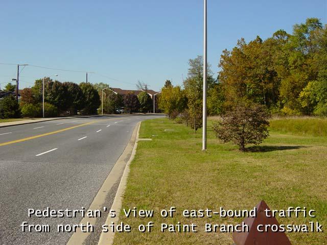
1 Haitham A. Hijazi, Director Department of Public Works and Transportation 9400 Peppercorn Place Suite 300 Largo, MD January 9, 2006 Dear Director Hijazi; On behalf of the Berwyn District Civic Association, I would like to urge the Department of Public Works and Transportation to install a pedestrian controlled traffic signal at the intersection of Paint Branch Parkway and the City of College Park s Trolley Trail (also known as the Paint Branch Trail). The people in our neighborhood have a great deal of interest in the Paint Branch Trail. It gives us easy access to the metro station, it provides us a thoroughfare for visiting our neighbors in Old Town, and it lets us commute to our offices on River Road all without adding to the congestion on Route 1. Unfortunately, we feel the trail's crosswalk at Paint Branch Parkway is just not safe. Athe Trail ends abruptly at Paint Branch Parkway, a major road, four lanes wide. The curve of the road to the west allows only about 600 feet of visibility for a pedestrian to see east-bound cars approaching, or for drivers to see pedestrians entering the crosswalk. The posted speed limit on Paint Branch Parkway is thirty-five mph. At this speed, a car that is out of sight of a pedestrian can be on top of the crosswalk in less than 12 seconds. A pedestrian can count on less than 12 seconds to safely cross four lanes of traffic. This might not be difficult for a healthy jogger or a bicyclist, but imagine a mother with a stroller, an elderly walker, or a wheelchair-bound pedestrian. Paint Branch Parkway is a wide, moderately-traveled, limited access stretch of road east-bound from Route 1 to the Trail. This makes the speed limit easy to ignore, particularly for drivers who have recently been stuck in a Route 1 backup. A driver traveling at just five miles over the speed limit reduces the time for a pedestrian to safely cross to 10 seconds. What's more, landscaping efforts on the north side of the road near the crosswalk threaten to reduce the visibility to less than 400 feet-- less than 7 seconds. This still seems like a significant amount of time for a driver to spot a pedestrian and slow down, until you consider that the environment of Paint Branch Parkway does not suggest that crossing pedestrians are likely. One side of the road is a solid sound barrier wall. The opposite side, a dense forest with no sidewalk. An east-bound driver who is not familiar with the road has no reason to expect that a pedestrian would ever try to cross it; there is nothing visible on either side for a pedestrian to cross to.
2 Despite the existing markings and signs, this crosswalk is simply not in a location where one would expect to see pedestrians in the roadway and experience ofour local pedestrians tells us that cars are not slowing down; crossing remains stressful in that area. During rush hour pedestrians often have to wait a long time to find a gap in traffic, and sometimes they risk crossing between cars with little gap at all. We believe that a traffic light will be an unmistakable signal to drivers that an intersection is there. A red light stands out to a driver more than a pedestrian under any circumstances. If this traffic signal only turns red at the request of a pedestrian waiting to cross, the effect on traffic flow will be minimal. The addition of a crosswalk signal with a count-down timer will ensure that pedestrians of any capability have sufficient time to cross the road in safety. The residents of Berwyn have a vested interest in the safety of the Paint Branch Parkway crosswalk. At the present time, we feel that the crosswalk is not sufficiently visible to drivers, and does not allow all users sufficient time to cross a wide road, even when it appears to be clear of vehicles. We believe that a pedestrian controlled traffic signal will significantly improve safety at the crosswalk with little disruption to traffic flow for only a modest investment. We thank you for your time and your consideration. Sincerely, Heather Iliff President Berwyn District Civic Association Attachments: Overhead View Photo, Driver s View Photo, Pedestrain s View Photo CC: Stephen A. Brayman, Robert T. Catlin, Thomas Dernoga, Andrew M. Fellows, John Giannetti, Emily Guskin, Karen E. Hampton, Thomas Hendershot, Jack B. Johnson, John M. Krouse, Pauline Menes, David L. Milligan, Brian Moe, Eric C. Olson, Joseline Peña-Melnyk, John E. Perry,

3

4
5
EXECUTIVE SUMMARY. Vision
 Vision Walking and bicycling in Salt Lake City will be safe, convenient, comfortable, and viable transportation options that connect people to places, foster recreational and economic development opportunities,
MUNICIPALITY OF ANCHORAGE TRAFFIC CODE UPDATE MASTER RECOMMENDATION REPORT: 9.20, 9.38
 MUNICIPALITY OF ANCHORAGE TRAFFIC CODE UPDATE MASTER RECOMMENDATION REPORT: 9.20, 9.38 Report Date: Please send all recommendations for update to Shane Locke (343-8413, lockesr@muni.org) 20-May-09 Code
Riverside Drive Complete Streets Project 3 rd Community Meeting. March 26, 2015
 Riverside Drive Complete Streets Project 3 rd Community Meeting March 26, 2015 Providing Feedback Sign-In with contact information for future updates Complete questionnaire provided tonight Complete comment
Neighborhood Slow Zone Program Application
 Neighborhood Slow Zone Program Application 2018-2019 Promoting traffic safety on neighborhood streets Applications due by Friday, January 18, 2019 Jointly led by Managing Director s Office of Transportation,
ROUNDABOUTS/TRAFFIC CIRCLES
 GENERAL 1. Description This standard identifies minimum requirements that shall be met for Roundabouts and Neighborhood Traffic Circles in the design and construction of elements for Arlington County Horizontal
PRINCE GEORGE S PLAZA METRO AREA PEDESTRIAN PLAN
 PRINCE GEORGE S PLAZA METRO AREA PEDESTRIAN PLAN May 28, 2008 Agenda Welcome and introductions Project overview and issue identification Planning context and strengths Design challenges and initial recommendations
WORKING LESSON PLAN School Bus Driver In-Service
 WORKING LESSON PLAN 2005-2006 School Bus Driver In-Service TITLE OF LESSON Blind Spots at Intersections and Crosswalks OBJECTIVE At the conclusion of this lesson, the students will be able to: Describe
Drivers Responsibilities to Pedestrians
 Drivers Responsibilities to Pedestrians The following 60 slides use real photos, a video clip and quizzes to teach drivers what to do when they encounter a pedestrian. This takes about 5 minutes to view.
Government of the District of Columbia Department of Transportation
 Government of the District of Columbia Department of Transportation November 1, 2017 Stephen Gardner Advisory Neighborhood Commission 3D P.O. Box 40846 Palisades Station Washington, DC 20016 3D06@anc.dc.gov
H Jumpers Hole Road from MD 2 to MD 177. Compiled Online Posting Public Comments 11/9/17
 H539609 Jumpers Hole Road from MD 2 to MD 177 Compiled Online Posting Public Comments 11/9/17 1. Need a traffic light and safe bicycle and pedestrian passage. Countless situations where cars put peds in
Vehicular turning and path of travel with a proposed curb bulb on the southwest corner of Mount Diablo Boulevard and Dewing Avenue.
 October 3, 2014 James Shively Stantec 100 California Street, Suite 1000, San Francisco CA 94111-4505 Subject: Traffic Study for Proposed Lafayette Chase Bank Dear Mr. Shively: Pursuant to your request,
Retrofitting Urban Arterials into Complete Streets
 Retrofitting Urban Arterials into Complete Streets John N. LaPlante, P.E., P.T.O.E., T.Y. Lin International Prepared for: Illinois Traffic Engineering & Safety Conference Urbana, Illinois October 18, 2007
1. Places where one road meets or crosses another are called intersections. F
 Intersections STUDY GUIDE OR CHAPTER 10 LESSON 1 Basic Intersections A. or each sentence below, circle T if the statement is true and if it is false. Correct each false 1. Places where one road meets or
The Wiggle Route in Context
 The Wiggle Route in Context In a city of hills, the Wiggle is an important route because it winds its way along the flattest streets from Market to the Panhandle, bringing residents to local parks and
EVERYONE IS A PEDESTRIAN CROSSING ADVICE FOR PEDESTRIANS
 B I C Y C L I N G I N C O L O R A D O EVERYONE IS A PEDESTRIAN CROSSING ADVICE FOR PEDESTRIANS Most of us cross streets every day. We take for granted that we can cross without incident because most of
Broadway Complete Streets Project
 Broadway Complete Streets Project Megan Johnson, P.E. Associate Civil Engineer James Pangburn, P.E. Consultant Project Manager After the construction of the highway system, Broadway was cut off
12/4/2016 VIA . RE: Grocery Outlet Del Paso (DR16-328)
") 12/4/2016 VIA EMAIL Ethan Meltzer, Assistant Planner City of Sacramento Community Development Department 300 Richards Blvd, 3 rd Floor Sacramento, CA 95811 RE: Grocery Outlet Del Paso (DR16-328) Dear Mr.
12/4/2016 VIA EMAIL Ethan Meltzer, Assistant Planner City of Sacramento Community Development Department 300 Richards Blvd, 3 rd Floor Sacramento, CA 95811 RE: Grocery Outlet Del Paso (DR16-328) Dear Mr.
MASTER BICYCLE AND PEDESTRIAN PLAN
 VILLAGE OF NORTHBROOK MASTER BICYCLE AND PEDESTRIAN PLAN DRAFT PLAN OPEN HOUSE May 2, 2018 AGENDA 1. Community Engagement 2. Vision and Goals 3. General Structure of Plan 4. Recommendations Overview 5.
Winnipeg Walk Bike Projects Downtown Tire Talk - Summary
 Winnipeg Walk Bike Projects Downtown Tire Talk - Summary Downtown Projected Bike Lane System Connecting The Forks to the Exchange District (Fort Street, Garry Street & The Forks to Assiniboine Connection)
Bicycles and Pedestrians on ISU Campus. Indiana State University Police
 Bicycles and Pedestrians on ISU Campus Indiana State University Police FASTEST Transportation On Campus There has been an increase in cyclists and pedestrians on campus as student enrollment continues
Agenda. Overview PRINCE GEORGE S PLAZA METRO AREA PEDESTRIAN PLAN
 PRINCE GEORGE S PLAZA METRO AREA PEDESTRIAN PLAN May 28, 2008 Agenda Welcome and introductions Project overview and issue identification Planning context and strengths Design challenges and initial recommendations
Bicycle Network. Vision Zero San Francisco The City and County of San
 PROJECT BACKGROUND Project Needs 1. 17th between Church and Sanchez is identified as a location where there is a disproportionate number of crashes involving people riding bikes. 2. There is currently
Giles Run Connector Road
 Giles Run Connector Road Laurel Hill Adaptive Reuse Area to Laurel Crest Drive South County Federation Meeting June 14, 2016 History Connector road included in the Laurel Hill Comprehensive Plan amendment
Blue Ribbon Commission Report Recommendations on Pedestrian and Bicycle Infrastructure Improvements
 Recommendations on Pedestrian and Bicycle Infrastructure Improvements July 2017 Plan Development: Our committee consisted of seven individuals appointed by the Mayor and Village Board. Those members included:
Strategies for Sharing the Road with Other Users
 Idaho Driver Education and Training Strategies for Sharing the Road with Other Users M15-1 Sharing the Road Introduction Idaho law requires motorists to operate their vehicles in a careful and prudent
STEVEN AND SUE REVITZ
 STEVEN AND SUE REVITZ 1335 NORTH DOHENY DRIVE LOS ANGELES, CALIFORNIA 90069 Members of the Planning and Land Use Management Committee c/o City Clerk Room 395 City Hall 200 N. Spring Street Los Angeles,
o n - m o t o r i z e d transportation is an overlooked element that can greatly enhance the overall quality of life for the community s residents.
 N o n - m o t o r i z e d transportation is an overlooked element that can greatly enhance the overall quality of life for the community s residents. 84 Transportation CHAPTER 11 INTRODUCTION Transportation
Active Transportation Facility Glossary
 Active Transportation Facility Glossary This document defines different active transportation facilities and suggests appropriate corridor types. Click on a facility type to jump to its definition. Bike
MEET IN THE STREET MOVING TO ZERO
 WE MEET IN THE STREET MOVING TO ZERO Tips for sharing the street Traffic deaths are preventable. We need your help getting the message out. 2 A NEW PLAN A NEW PLAN Philadelphia is proud to adopt Vision
City of Seattle Edward B. Murray, Mayor
 City of Seattle Edward B. Murray, Mayor Department of Transportation Scott Kubly, Director Eastlake Community Council 117 E Louisa St. #1 Seattle, WA 98102-3278 January 28, 2016 RE: Roosevelt to Downtown
GARLAND ROAD/GASTON AVENUE/ GRAND AVENUE INTERSECTION IMPROVEMENT STUDY
 MEETING OF AFFECTED PROPERTY OWNERS AND STAKEHOLDERS GARLAND ROAD/GASTON AVENUE/ GRAND AVENUE INTERSECTION IMPROVEMENT STUDY CSJ 0009-02-067 Meeting Agenda 1 2 3 4 5 6 7 8 9 10 Opening Remarks State Representative
Ohio Share the Road Driver s s Education Unit
 Ohio Share the Road Driver s s Education Unit Bicyclists are Drivers of Vehicles 4501.01. Definitions (A) "Vehicle" means every device, including a motorized bicycle, in, upon, or by which any person or
Bicyclists and Truck Driver Visibility
 Bicyclists and Truck Driver Visibility Posting Date: 08-Aug 2014 On August 7th, 2014 a 19-year-old female cyclist was killed when her bicycle was run over by a concrete mixer truck at the intersection
Appendix C. TRAFFIC CALMING PROGRAM TOOLBOX
 Appendix C. TRAFFIC CALMING PROGRAM TOOLBOX PHASE I...2 Do Not Enter Sign...3 One-Way Sign...4 Turn Prohibition...5 Pavement Markings...6 Speed Monitoring Trailer...7 Neighborhood Speed Watch...8 Police
Controlled. Semi-Controlled PAGE 01 CHAPTER 12 INTERSECTIONS
 PAGE 01 CHAPTER 12 INTERSECTIONS You will cross many intersections while driving. Intersections are especially dangerous because vehicles are crossing each other s driving path. Many crashes happen at
SAFETY ADVISORY AND TRANSPORTATION COMMITTEE A G E N D A
 SAFETY ADVISORY AND TRANSPORTATION COMMITTEE A G E N D A October 13, 2004-7:00 P.M. Public Assembly Room - 400 S. Queen Street - Dover Public comments are welcomed on any item and will be permitted at
North Buckhead Civic Association. Recommendations For Wieuca Road
 North Buckhead Civic Association Recommendations For Wieuca Road October 7, 2009 Blank Page Page 2 of 16 Table of Contents 1. BACKGROUND 4 2. TRAFFIC SIGNALS AND ALL WAY STOPS 5 3. SPEED LIMITS AND SPEED
In the Interest of Safety: Transit Safety Slide Reference Guide
 In the Interest of Safety: Transit Safety Slide Reference Guide Slide T-1: In the Interest of Safety: Transit Safety Welcome to In the Interest of Safety: Transit Safety. Suggested Opening: Thank you for
NAPIER AVENUE PEDESTRIAN AND BICYCLE PLAN
 NAPIER AVENUE PEDESTRIAN AND BICYCLE PLAN Prepared By: DRAFT: 1/17/1 WHAT ARE WALKABILITY AUDITS AND WHY ARE THEY IMPORTANT? Walkability is important for a community and everyone benefits from walking.
LTAC: Katie Mencarini, Central & Hampton Roads streets and a fifteen minute debrief to discuss the findings. Participants walked along Mill Road
 Walkabout Summary On June 3, 2013, five participants met at Glen Allen Elementary School in Glen Allen, Virginia to take a closer look at the walking and biking network around the school. In addition to
Front and Myrtle Improvement Project
 Front and Myrtle Improvement Project MAKING BOISE THE MOST LIVABLE CITY IN THE COUNTRY DOWNTOWN: Our unique and vibrant urban neighborhood GUIDING PRINCIPLES: Innovation Celebration Transportation Downtown
River Road Healthy Neighborhood Walkabout October 15, 2016
 River Road Healthy Neighborhood Walkabout October 15, 2016 Conversation and Questions: A. What are the best things about your neighborhood? B. In what areas does your neighborhood need improvement? C.
10/30/2012 VIA
 10/30/2012 VIA EMAIL David Hung, Associate Planner Community Development Department, Current Planning Division City of Sacramento 300 Richards Blvd., 3 rd Floor Sacramento, CA 95811 RE: The Cannery On-Site
Cross Street Corridor Non-Motorized Enhancement Project Project Description
 Cross Street Corridor Non-Motorized Enhancement Project Project Description A cooperative study of the Cross Street neighborhood was completed in May 2002 by the City of Ypsilanti, the Depot Town Downtown
SLOW DOWN A STUDY OF SPEEDING ON MCGUINNESS BLVD
 SLOW DOWN A STUDY OF SPEEDING ON MCGUINNESS BLVD ACKNOWLEDGEMENTS This report was prepared by Shawn Macias, in consultation with the McGuinness Boulevard Working Group. This report would not have been
G AT E WAY PLAN. Community BRIEFING KIT GATEWAY BIKE
 G AT E WAY PLAN GATEWAY BIKE Community BRIEFING KIT PLAN August 2016 TABLE OF CONTENTS INTRODUCTION... 1 THE BENEFITS OF A BIKEABLE COMMUNITY... 2 ECONOMY...2 SAFETY...3 HEALTH...3 HOUSEHOLD SPENDING...3
RE: Natomas Landing (P99-091)
") August 2, 2008 David Hung, Associate Planner Current Planning Division Development Services Department 300 Richards Boulevard, 3rd Floor Sacramento, CA 95811 RE: Natomas Landing (P99-091) Dear Mr. Hung:
August 2, 2008 David Hung, Associate Planner Current Planning Division Development Services Department 300 Richards Boulevard, 3rd Floor Sacramento, CA 95811 RE: Natomas Landing (P99-091) Dear Mr. Hung:
Mineral Avenue Corridor Assessment. ITE 2017 Western District Annual Meeting San Diego, CA June 21 st
 Mineral Avenue Corridor Assessment ITE 2017 Western District Annual Meeting San Diego, CA June 21 st Biography - Aaron Heumann, PE, PTOE Currently City of Littleton Transportation Engineering Manager 24
Business owner or commercial property owner in Arlington, 8. Visitor in Arlington, 17
 1. How do you currently travel around your neighborhood? (Select your top 3) Resident of Arlington 86.72% 222 Worker in Arlington 20.70% 53 Business owner or commercial property own 3.13% 8 Visitor in
9/21/2016 VIA . RE: The Knot (DR16-270)
") 9/21/2016 VIA EMAIL Garrett Norman, Assistant Planner City of Sacramento Community Development Department 300 Richards Boulevard, 3 rd Floor Sacramento, CA 95811 RE: The Knot (DR16-270) Dear Mr. Norman:
9/21/2016 VIA EMAIL Garrett Norman, Assistant Planner City of Sacramento Community Development Department 300 Richards Boulevard, 3 rd Floor Sacramento, CA 95811 RE: The Knot (DR16-270) Dear Mr. Norman:
SUMMARY OF TRANSPORTATION INVESTMENTS
 Santa Cruz County 2016 Measure D: Transportation Improvement Expenditure Plan - Approved by over 2/3 of Santa Cruz County voters on November 8, 2016 - Overview Measure D, the 2016 Transportation Improvement
Intersection Improvement: Sturgeon Road, Silver Avenue and Murray Park Road Roundabout. Welcome. Public Information Session
 Intersection Improvement: 1 Welcome WHY IS AN INTERSECTION IMPROVEMENT NEEDED? 2 Traffic volumes for Sturgeon Road, Silver Avenue and Murray Park Road exceed the capacity of the existing 4-way stop controlled
Pedestrian Safety at Roundabouts. Presentation to the Howard-Suamico School Board November 26, 2007
 Pedestrian Safety at Roundabouts Presentation to the Howard-Suamico School Board November 26, 2007 Roundabouts that have replaced stop signs and traffic signals have reduced the number and severity of
City of Wilsonville 5 th Street to Kinsman Road Extension Project
 City of Wilsonville 5 th Street to Kinsman Road Walking Tour & Neighborhood Workshop Summary Report Public Outreach Overview On July 18 th, 2017, the City of Wilsonville hosted a neighborhood walking tour
Flags Over Dane County Adopt-A-Crosswalk Program
 Flags Over Dane County Adopt-A-Crosswalk Program Safe Community Coalition of Madison and Dane County What is the Pedestrian Flags Over Dane County Adopt-A-Crosswalk Program? The Adopt-A-Crosswalk Pedestrian
$ 12" $#&%$ 86.) *1! *1 /3 )00, , (1* Neighborhood Traffic Calming Part 3 Solutions Bradley William Yarger, P.E.
 *1! *1 /3 )00, , (1* Neighborhood Traffic Calming Part 3 Solutions Bradley William Yarger, P.E.") $ 12" $#&%$ 86.)3+5+2 714 *1! *1 /3 )00,12 3.+ -0127 1, (1* Neighborhood Traffic Calming Part 3 Solutions by Bradley William Yarger, P.E. It is extremely tempting to jump to this step of the process thinking
$ 12" $#&%$ 86.)3+5+2 714 *1! *1 /3 )00,12 3.+ -0127 1, (1* Neighborhood Traffic Calming Part 3 Solutions by Bradley William Yarger, P.E. It is extremely tempting to jump to this step of the process thinking
COWETA HIGH SCHOOL AND EAST HIGHWAY 51
 COWETA HIGH SCHOOL AND EAST HIGHWAY 51 Lack of sidewalks along Ben Lumpkin Rd. Lack of crosswalks and ramps at intersection. Hwy 51 is wide to cross as a pedestrian. No ADA compliance or connection to
6/14/2013 VIA . Evan Compton, Associate Planner Community Development Department City of Sacramento 300 Richards Blvd Sacramento, CA 95814
 6/14/2013 VIA EMAIL Evan Compton, Associate Planner Community Development Department City of Sacramento 300 Richards Blvd RE: Sacramento Natural Foods Co-Op (P13-025) Dear Mr. Compton: WALKSacramento appreciates
TRAFFIC CALMING PLANNER S PORTFOLIO
 TRAFFIC CALMING PLANNER S PORTFOLIO ISSUE 8 January 2017 PLANNER S PORTFOLIO TRAFFIC CALMING 1 OVERVIEW 2 3 4 ENGINEERED TRAFFIC CALMING MEASURES SIGNS AND PAVEMENT MARKINGS EMERGENCY RESPONSE DELAYS 5
Guidance. ATTACHMENT F: Draft Additional Pages for Bicycle Facility Design Toolkit Separated Bike Lanes: Two-Way to One-Way Transitions
 ATTACHMENT F: Draft Additional Pages for Bicycle Facility Design Toolkit Separated Bike Lanes: Two-Way to One-Way Transitions This treatment provides a transition from two-way separated bike lanes to one-way
SETTINGS AND OPPORTUNITIES MOBILITY & ACCESS
 7 mobility & access how do people use el camino what is it like to drive on el camino/to park along el camino what is the pedestrian experience like what is the role of transit along the corridor what
Pedestrian Survey Report
 Pedestrian Survey Report The City of Albany conducted a Pedestrian Survey in 2007 with the purpose of identifying resident s concerns about barriers to walking and accessibility in the City. The survey
HYATTSVILLE TRANSPORTATION PLAN. City Council Update March 19, 2018
 HYATTSVILLE TRANSPORTATION PLAN City Council Update March 19, 2018 AGENDA PROJECT GOALS DATA COLLECTION WHAT WE LEARNED NEXT STEPS PROJECT GOALS Identify bicycle and pedestrian needs of the city Evaluate
6/22/2018 VIA . Darcy Goulart, Planning Manager City of Rancho Cordova Planning Department 2729 Prospect Park Drive Rancho Cordova, CA 95670
 6/22/2018 VIA EMAIL Darcy Goulart, Planning Manager City of Rancho Cordova Planning Department 2729 Prospect Park Drive Rancho Cordova, CA 95670 RE: Quick Quack Car Wash (DD9801) Dear Ms. Goulart: WALKSacramento
PISMO BEACH COUNCIL AGENDA REPORT SUBJECT/TITLE: STATUS REPORT OF THE TRAFFIC SAFETY COMMITTEE SEPTEMBER 11 AND OCTOBER 6, 2014
 PISMO BEACH COUNCIL AGENDA REPORT SUBJECT/TITLE: STATUS REPORT OF THE TRAFFIC SAFETY COMMITTEE SEPTEMBER 11 AND OCTOBER 6, 2014 RECOMMENDATION: On Consent Calendar, City Council to approve the recommendation
This page intentionally left blank.
 This page intentionally left blank. COMMUNITY Coweta Community Overview Coweta Coweta, a residential community located in Wagoner County, is a suburb of Tulsa situated southeast of the metropolitan area
WALKscope Data Challenge Tip Sheet
 WALKscope Data Challenge Tip Sheet Help us map where sidewalks end and win prizes for your neighborhood! WalkDenver & Denver Environmental Health (DEH) s Community Active Living Coalition (CALC) are proud
3/10/2016 VIA th Street, Suite 203 Sacramento, CA
 3/10/2016 VIA EMAIL Arwen Wacht, Associate Planner City of Sacramento Community Development Department 300 Richards Boulevard, 3 rd Floor Sacramento, CA 95811 RE: Natomas Fountains (P16-012) Dear Ms. Wacht:
ORANGE COUNTY PUBLIC WORKS TRAFFIC INVESTIGATIONS
 ORANGE COUNTY PUBLIC WORKS TRAFFIC INVESTIGATIONS STAFF REPORT OF: January 6, 2019 SUPERVISORIAL DISTRICT: 5 SUBJECT: LOCATION: INVESTIGATOR: O Neill Drive at Roanoke Drive; Ladera Ranch; TB 922-E6 Clever
LAGUNA BEACH POLICE DEPARTMENT MEMORANDUM
 LAGUNA BEACH POLICE DEPARTMENT MEMORANDUM TO: FROM: Christa Johnson, Assistant City Manager Jason C. Kravetz, Captain DATE: January 16, 2015 SUBJECT: Laguna Canyon Road Collision Analysis Within the last
El Paso County 2040 Major Transportation Corridors Plan
 El Paso County 2040 Major Transportation Corridors Plan Connect-our-County Online Transportation User Survey Preliminary Results June 24, 2010 Years of Residence 2. How many years have you LIVED HERE?
TO: VDoT, FDoT. CC: Cathy Hudgins, Paul Davis FROM: RA. RE: Critical intersections surrounding the Wiehle-Reston East Metro station
 TO: VDoT, FDoT CC: Cathy Hudgins, Paul Davis FROM: RA RE: Critical intersections surrounding the Wiehle-Reston East Metro station As the Wiehle-Reston East Metro Station nears operation, Reston Association
Identify the letter of the choice that best completes the statement or answers the question.
 Chapter 02 - Practice Questions Multiple Choice Identify the letter of the choice that best completes the statement or answers the question. 1) No-parking zones often are near a. fire hydrants, curves,
Southside Road. Prepared for: City of St. John s Police & Traffic Committee. Prepared by: City of St. John s Traffic Division
 Southside Road Prepared for: City of St. John s Police & Traffic Committee Prepared by: City of St. John s Traffic Division January 2007 Southside Road - Traffic Report Page 1 of 9 BACKGROUND: th At the
Lake Whitney Elementary School
 Lake Whitney Elementary School SCHOOL ROUTE PLAN For LAKE WHITNEY ELEMENTARY SCHOOL LOCATION 18 ORANGE COUNTY Prepared for: ORANGE COUNTY SCHOOL ASSESSMENT PROGRAM ORANGE COUNTY PUBLIC WORKS Traffic Engineering
PLACEMENT OF SIGNS RECOMMENDED PRACTICES SUB-SECTION
 Page 1 of 6 RECOMMENDED PRACTICES PART SECTION SUB-SECTION HIGHWAY SIGNS GENERAL General Proper positioning of signs is an important element in the overall control of traffic within a roadway network.
Basic Rules of Pedestrian Safety (Primary, Elementary)
") Basic Rules of Pedestrian Safety (Primary, Elementary) Grouping Individual Pair Small Group Whole Class Purpose To provide students with the basic knowledge and skill practice necessary to be safe pedestrians
Basic Rules of Pedestrian Safety (Primary, Elementary) Grouping Individual Pair Small Group Whole Class Purpose To provide students with the basic knowledge and skill practice necessary to be safe pedestrians
Walking Audit Supporting Information
 Walking Audit Supporting Information Planning to do a walking audit of your streets? Here s some helpful suggestions to help get you started. 1. Preparing for your audit Decide where you want to walk.
MUTCD Part 6D: Pedestrian and Worker Safety
 MUTCD Part 6D: Pedestrian and Worker Safety Section 6D.01 Pedestrian and Worker Safety The needs and control of all road users (motorists, bicyclists, and pedestrians) within the highway, including persons
Physical Implications of Complete Streets Policies
 Presentation Overview Physical Implications of Complete Norm Cox, ASLA, LLA Landscape Architect Ann Arbor, Michigan, 10:45 to Noon What Are Complete Streets? What Matters to Bicyclists and Pedestrians
City of Vallejo Traffic Calming Toolbox
 City of Vallejo Traffic Calming Toolbox June 1, 2013 Final Table of Contents Introduction... 1 Non-Physical Devices... 3 High-Visibility Crosswalk... 3 In Pavement Lighted Crosswalk... 4 Rapid Flashing
11/28/2016 VIA
 11/28/2016 VIA EMAIL Ethan Meltzer, Assistant Planner City of Sacramento Community Development Department 300 Richards Blvd., 3 rd Floor Sacramento, Ca 95811 RE: Natomas Corporate Center Commercial Building
City of Novi Non-Motorized Master Plan 2011 Executive Summary
 City of Novi Non-Motorized Master Plan 2011 Executive Summary Prepared by: February 28, 2011 Why Plan? Encouraging healthy, active lifestyles through pathway and sidewalk connectivity has been a focus
AGENDA REPORT. Issue: Discussion of potential improvements on Barnwell Road at Niblick Drive
 AGENDA REPORT To: From: By: Honorable Mayor and City Council Members Warren Hutmacher, City Manager Tom Black, Public Works Director Date: March 23, 2016 Agenda: March 28, 2016 WORK SESSION AGENDA: Barnwell
Session 76 Pedestrians and Intersections
 Session 76 Pedestrians and Intersections Moderator: Meg Storrow, RLA Storrow Kinsella Associates Andrew Gast-Bray, PhD, AICP Storrow Kinsella Associates (former) Michael Koslow, PE Storrow Kinsella Associates
City of Sammamish. Welcome. Issaquah-Fall City Road Improvements Project Phase I Design: 242nd Avenue SE to Klahanie Drive SE
 Welcome Welcome to the third community meeting for the Issaquah-Fall City Road Improvements Project. AGENDA 6:00 p.m. Welcome and sign-in 6:10 p.m. Presentation 6:50 p.m. Open house Learn about the roadway
Fitting Light Rail through Well-established Communities
 Fitting Light Rail through Well-established Communities San Francisco 2008 Michael D. Madden Chief, Project Development, Maryland Transit Administration Project Setting Located inside the Capital Beltway
PETITION AND LETTER WRITING BEST PRACTICES
 PETITION AND LETTER WRITING BEST PRACTICES Petitions and campaign letters can be a great way to bring important bicycle and pedestrian policies and projects to the attention of elected officials. They
General Design Factors
 Chapter 3: 3-1.0 Introduction General Design Factors Mn/DOT s goals include encouraging and accommodating safe bicycling. From a design perspective, these goals are achieved by first having an understanding
Open House #1 Summary
 Open House #1 Summary Date: Tuesday, December 09, 2014 Time: Location: 6PM TO 8PM Centennial High School Cafeteria, 3505 SE 182 nd Ave., Gresham, OR The first public open house event for the US 26: Outer
Everyday Hazards for School Bus Drivers. Reference Guide and Test
 1 Everyday Hazards for School Bus Drivers Reference Guide and Test 2 Introduction One of the most important and often overlooked issues for school bus drivers is hazards. During the course of the video,
Pedestrian Crossing Facilitation Guideline Development
 Pedestrian Crossing Facilitation Guideline Development TZD Conference Melissa Barnes October, 2017 Why? Minnesota Go: Minnesota s multimodal transportations system maximizes the health of people, the environment,
Kingwood Area Mobility Study. Lake Houston Redevelopment Authority (TIRZ #10)
") Kingwood Area Mobility Study Lake Houston Redevelopment Authority (TIRZ #10) Steering Committee Meeting #3 Date: May 27, 2014 Introductions/Remarks Steering Committee Project/Consultant Team GOALS & MOE
Kingwood Area Mobility Study Lake Houston Redevelopment Authority (TIRZ #10) Steering Committee Meeting #3 Date: May 27, 2014 Introductions/Remarks Steering Committee Project/Consultant Team GOALS & MOE
5. RUNNINGWAY GUIDELINES
 5. RUNNINGWAY GUIDELINES These guidelines should be considered collectively when making runningway decisions. A runningway is the linear component of the transit system that forms the right-of-way reserved
Seattle Department of Transportation (SDOT) Preliminary Responses to Madison-Miller Community List of Site-Specific Concerns
 Preliminary Responses to Madison-Miller Community List of Site-Specific Concerns") Seattle Department of Transportation (SDOT) Preliminary Responses to Madison-Miller Community List of Site-Specific Concerns Background In July 2002 SDOT staff met with a small group of community residents
Seattle Department of Transportation (SDOT) Preliminary Responses to Madison-Miller Community List of Site-Specific Concerns Background In July 2002 SDOT staff met with a small group of community residents
Northeast 65 th Street Vision Zero Project Proposals From A Roosevelt High School Student Joe Mangan
 Northeast 65 th Street Vision Zero Project Proposals From A Roosevelt High School Student Joe Mangan PROPOSALS: 1. Extend raised cycle tracks down 65 th Street Northeast. Please do not consider any other
9/22/2014 VIA . RE: Butano Apartments Pre App (PAMP )
") 9/22/2014 VIA EMAIL Surinder Singh, Senior Planner Planning and Environmental Review Division Sacramento County 827 7th Street, Second Floor RE: Butano Apartments Pre App (PAMP2014-00012) Dear Mr. Singh:
9/22/2014 VIA EMAIL Surinder Singh, Senior Planner Planning and Environmental Review Division Sacramento County 827 7th Street, Second Floor RE: Butano Apartments Pre App (PAMP2014-00012) Dear Mr. Singh:
133 rd Street and 132 nd /Hemlock Street 132 nd Street and Foster Street MINI ROUNDABOUTS. Overland Park, Kansas
 133 rd Street and 132 nd /Hemlock Street 132 nd Street and Foster Street MINI ROUNDABOUTS Overland Park, Kansas September 1, 2017 TABLE OF CONTENTS 1. INTRODUCTION... 1 2. LITERATURE REVIEW... 1 3. CONCEPT
SECTION 1 - CONTACT INFORMATION
 SECTION 1 - CONTACT INFORMATION Please complete the information below. The person identified as the Project Contact Person will be the primary point of contact for Georgia DOT staff. Organization: (Please
Catholic Primary School Tel: To follow in Jesus' footsteps, caring for
 Dear Parents Now that the summer term is here please consider the following, thank you 2 nd May 2017 Potential Park and Stride Sites for Parents To reduce congestion around the school gate we are encouraging