2014 Street and Utility Improvement Project. Feasibility Report January 28, 2014
|
|
|
- Jody Owens
- 5 years ago
- Views:
Transcription


1 2014 Street and Utility Improvement Project Feasibility Report January 28, 2014
2 Public Informational Meeting 22 residents from 17 properties signed in Questions about construction (FAQs) Eyebrow cul-de-sac The Banana Strong support for keeping this feature Sidewalk (Lake Drive to Lexington Avenue) Identified in the Pedestrian Facility Plan Residents had varying opinions Construct the full sidewalk connection No sidewalk is needed Sidewalk only from Lake Drive to Carl Eck Park

3 Presentation Summary Project Location Existing Conditions Proposed Improvements Project Costs Assessments / Funding Schedule Questions and Comments


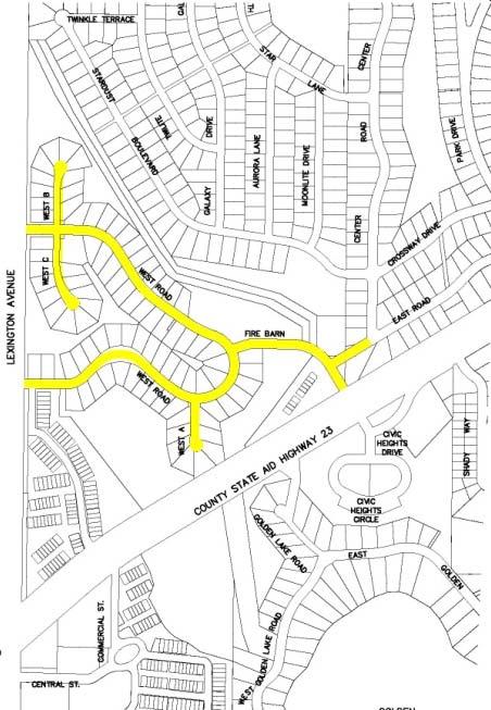

4 Project Location

 Condition index rated as Poor according to 2011 Pavement")
5 Street Existing Conditions 1.1 miles of residential streets constructed in 1968 Prevalent cracking in pavement (alligator, transverse, longitudinal, and edge) Condition index rated as Poor according to 2011 Pavement Management Program Fire Barn Road East Road
6 Existing Conditions Sanitary Sewer Root intrusion in mainline and service lines, cracked segments, and mineral deposits at joints Fire Barn Road sanitary sewer has significant sags Infiltration Water Main Existing main line is cast iron pipe Occasional breaks Hydrants adjacent to driveway Storm Sewer Existing storm sewer pipes are sized for current design standards Storm sewer directly discharges to ditch Surface flow can cause surface deterioration of the pavement

7 Proposed Improvements Street Reconstruction Existing Widths foot street widths Complete reconstruction including curb and gutter, bituminous pavement, and subgrade preparation Proposed Widths West Road, Fire Barn Road, and East Road to be 32 feet wide 32 foot width allows for parking on one side West Road A, B, and C cul-de-sacs to be 28 feet wide
8 Proposed Improvements Storm Sewer Drainage Improvements Resident noted drainage concerns: Corner of West Road and West Road A West Road B cul-de-sac Utilize segments of existing storm sewer outlet pipe between West Road / Fire Barn Road and County Ditch Storm Water Treatment Discussed several options with RCWD to permit for 2014 project, 2012 project debit, and credits for future projects Proposed Infiltration Basin at Stardust Boulevard

9 Proposed Improvements
 Lexington Avenue")
10 Proposed Improvements Pedestrian Facilities 5-foot concrete sidewalk Pedestrian Facility Plan - Connection between Lake Drive and Lexington Avenue Sidewalk Options Lake Drive to Lexington Avenue Lake Drive to Carl Eck Park No Sidewalk Brick pattern crosswalk (Duratherm) Lexington Avenue intersections


11 Proposed Improvements Eyebrow Cul-de-sac Banana Propose to eliminate - maintenance issue


12 Carl Eck Park Alternative Parking Options Pave gravel/grass lot Delineate parking spaces


13 Carl Eck Park Alternative Parking Options Fire Barn Road bump out parking Crosswalk to ball fields
14 Intersection Improvements Fire Barn Road / Lake Drive / Civic Heights Drive


15 Intersection Improvements Pine Drive / Lake Drive
16 Proposed Improvements Gas Main Replacement (by Centennial Utilities) Dual 2 plastic gas main (1 main on each side of street) Gas service replacement from the main to the home meter Completed prior to construction Water Main Replacement 8 and 12 PVC water main 1 HDPE water services replaced to the Right-of-Way New hydrants and gate valves Sanitary Sewer Replacement 8 and 12 PVC sanitary sewer main 4 PVC sanitary sewer services replaced to the Right-of-Way
17 Proposed Improvements
18 Proposed Improvements Environmental Investigation Pipeline spill in 1982 at Fire Barn Road Magellan worked with MPCA to clean up Geotechnical sub-consultant noted strong fumes in 2013 Environmental Investigation Required Utility impacts
19 Proposed Improvements
20 Project Costs Summary of Cost Total Street Improvements $1,517,600 Sanitary Sewer Improvements $662,400 Water Main Improvements $599,600 Storm Sewer Improvements $462,900 Aesthetic Intersection Improvements $92,400 Total $3,334,900 Alternate 1 Sidewalk Improvements $99,200 Alternate 2 Parking Option 1 (Carl Eck Parking Lot) $82,000 Alternate 3 Parking Option 2 (Fire Barn Road Bump Out) $32,900 Total Alternates $214,100 Project Total (with Alt) $3,549,000
21 Assessment Policy and Funding Current Assessment Policy is a flat and equal rate Proposed Street Assessment: $3,950 per unit 90 single family residential units Townhomes are treated as one unit (10 Total Units) City owned parcels at West Rd C cul-de-sac (3 Total Units) Carl Eck Park area and Fire Station assessed one unit per 75- feet of front footage (same method as Inner Park) 17 Total Units City Funds Remaining Street Improvements City Funds 100% of Utility Improvements City Funds Aesthetic Intersection Improvements
22 Project Assessment Total Street Improvement Cost $1,517,600 Total Assessable Units 117* Assessment Rate $3,950 Total Assessment $462,150 *Includes three City-owned lots and 17 residential equivalent units for Carl Eck Park, the Carl Eck Park parking lot, and Centennial Fire Station totaling $79,000 * Assessment equates to $505/yr for 10 years at 5% (estimated- contingent on bond sale) interest rate

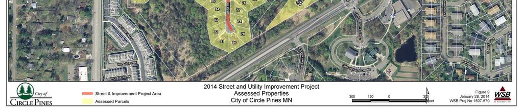
23 City Owned Parcels Assessable Units
24 Funding Scenario Proposed Funding Special Assessments $462,150 Street Reconstruction Fund $1,101,650 $1,317,750 Sanitary Sewer Fund $662,400 Water Main Fund $599,600 Storm Water Fund $462,900 General Fund $46,200 Total Funding $3,334,900 $3,549,000
25 Proposed Schedule Public Informational Meeting January 22, 2014 City Accepts Feasibility Study January 28, 2014 Public Hearing/ Authorize Plans February 18, 2014 Submit RCWD Permit February 28, 2014 City Approves Final Plans April 8, 2014 Receive Bids May 7, 2014 Award Contract May 13, 2014 Begin Construction June 2014 Substantial Completion October 2014 Assessment Hearing October 2014 Final Completion Spring 2015
26 Discussion Items Eyebrow Island Parking Alternatives Carl Eck Parking Lot Fire Barn Road bump out parking Sidewalk Sidewalk from Lake Drive to Lexington Avenue Sidewalk from Lake Drive to Carl Eck Park No Sidewalk Proposed Assessment Rate Current Rate is $3,500 per unit Proposed Rate is $3,950 per unit
27 Questions and Comments?
28 Questions and Comments?
2010 STANDARD SPECIFICATIONS STANDARD DRAWINGS
 CITY OF REDMOND, OREGON 2010 STANDARD SPECIFICATIONS STANDARD DRAWINGS TABLE OF CONTENTS SECTION 1 TRENCHES TITLE 1-1 Utility Trench 1-2 Water Line & Sewer Line Separation 1-3 RR X-ING Single/Joint Use
CITY OF ROCK ISLAND. 46th Street Reconstruction North of 28th Avenue to 29th Avenue. 29th Avenue Reconstruction 46th Street to 47th Avenue Court
 46th Street Reconstruction North of 28th Avenue to 29th Avenue 29th Avenue Reconstruction 46th Street to 47th Avenue Court 47th Street Court Reconstruction 29th Avenue to Cul-de-sac CITY OF ROCK ISLAND
SECTION 3 STREET DESIGN
 3.01 GENERAL SECTION 3 STREET DESIGN For purposes of geometric and structural design, streets shall be classified according to the following table. The City Engineer will determine the class of all proposed
Building Great Neighbourhoods BELLEVUE AND VIRGINIA PARK
 Building Great Neighbourhoods BELLEVUE AND VIRGINIA PARK This is Meeting 2 Unfortunately, some residents in Bellevue and Virginia Park received the wrong information for this public open house (Meeting
Final Sidewalk Feasibility Study
 Garfield Drive From Anastasia Drive to Elizabeth Place City of South Daytona July 23, 2009 Final Sidewalk Feasibility Study Prepared for: Prepared by: Final Sidewalk Feasibility Study Garfield Drive 2
4APNOIPF Vh, YII PTC CITY COUNCIL AGENDA REPORT. Honorable Mayor and City Council Members. 8K TH 63 River Crossing Bridge Replacement Project
 City of RE 4APNOIPF Vh, X` W\ YII PTC ING, CITY COUNCIL AGENDA REPORT Council Meeting Date: September 26, 2016 To: From: Agenda Item: Honorable Mayor and City Council Members Ron Rosenthal, Engineering
Poor pavement condition Substandard Intersections. / Substandard bike/pedestrian/transit accommodations. Driveway access Environmental concerns
 Public Informational Meeting University Avenue (Allen Boulevard Segoe Road) March 23, 2011 City of Madison City of Middleton Village of Shorewood Hills Dane County Existing Roadway Conditions Poor pavement
East Downtown Tax Increment Reinvestment Zone (TIRZ) No. 15 Infrastructure Assessment Study
 No. 15 Infrastructure Assessment Study") East Downtown Tax Increment Reinvestment Zone (TIRZ) No. 15 Infrastructure Assessment Study Houston, TX Technical Memorandum April 15 th, 2009 Prepare by: 2950 North Loop West, Ste. 900 Houston, TX 77092
East Downtown Tax Increment Reinvestment Zone (TIRZ) No. 15 Infrastructure Assessment Study Houston, TX Technical Memorandum April 15 th, 2009 Prepare by: 2950 North Loop West, Ste. 900 Houston, TX 77092
Building Great Neighbourhoods BONNIE DOON
 Building Great Neighbourhoods BONNIE DOON We Are Here Today To Explain the Neighbourhood Renewal Process Show you the Westwood Preliminary Design Ask for local knowledge Highlight the Local Improvement
20 minute presentation on proposed project. Comments and Questions following presentation. City of Madison
 20 minute presentation on proposed project Comments and Questions following presentation 2016 2017 Replace concrete pavement & base Replace curb and sidewalk as needed Proposed contra-flow bike lane Replace
Consult with manufacturers concerning permeation of the pipe walls, jointing materials, valve seats, etc.
 Design Manual Chapter 4 - Water Mains 4C - Facility Design 4C-1 Facility Design A. General Water mains and appurtenances, including hydrants and valves, should be provided along all streets including connections
CITY OF ROSEVILLE DESIGN STANDARDS
 CITY OF ROSEVILLE DESIGN STANDARDS Section 1 Purpose and Definitions 1-1 Purpose PD 1 1-2 Design Practice PD 1 1-3 Definitions PD 1 Section 2 General Requirements 2-1 Plans by an Appropriate Engineer GR
SAWS QA/QC CHECKLIST WATER ADJUSTMENT/RELOCATION PROJECTS
 SAWS QA/QC CHECKLIST WATER ADJUSTMENT/RELOCATION PROJECTS Project Name: SAWS Water Job No.: CSJ No. (if applicable): Date: AWS Consultant: PROJECT INFORMATION N/A Yes No Joint Bid (COSA/TxDOT) N/A Yes
Atwood Avenue Fair Oaks Avenue Cottage Grove Road
 Atwood Avenue Fair Oaks Avenue Cottage Grove Road Agenda Purpose Review project scope & goals Present design alternatives Gather feedback Answer Questions Format Open House Presentation Q&A Open House
CONTRACT 6 WATER SYSTEM CONSTRUCTION EASTHAM, MASSACHUSETTS GENERAL NOTES AND LEGEND. MARK DATE DESCRIPTION Approved by 1"=40' Scale FOR REVIEW
 Drawing file: I:\Eastham.217\Phase 1 - Eastham Water System\217-1401.06 Contract 6 Phase I WM\01 CAD\06 CONTRACT WATER DESIGN I.dwg Plot : Nov 13,2014-8:24am. GENERAL NOTES AND LEGEND Drawing file: I:\Eastham.217\Phase
This Chapter sets forth the minimum design, technical criteria and specifications to be used in the preparation of all roadway plans.
 4.1 GENERAL This Chapter sets forth the minimum design, technical criteria and specifications to be used in the preparation of all roadway plans. These Roadway Standards are for new construction and modification
ADA Training Standard Plans
 ADA Training Standard Plans SCREEN READABLE VERSION IS IN THE MAKING AND WILL BE MADE AVAILABLE SOON 2018 MnDOT 2 Standard Plans 2017 Overview Overview PROWAG and Curb Ramp Basics Curb Ramp Types ADA Curb
CITY OF ROSEVILLE DESIGN AND CONSTRUCTION DETAILS
 CITY OF ROSEVILLE DESIGN AND CONSTRUCTION DETAILS Trench Backfill Utility Trench Paving Backfill and Embedment TB 1 HDPE, SRHDPE & PVC Storm Drain Pipe Only (Nonrigid) Bedding and Backfill TB2 Deep Cut
5 Transit & Traffic. Overview
 5 Transit & Traffic Overview Montgomery Place s roadways and overall traffic circulation are unique in the city due to the narrow streets and avenues with boulevards; however, no sidewalks or curbs in
City of Margate, Florida. Neighborhood Traffic Management Manual
 City of Margate, Florida Neighborhood Traffic Management Manual Table of Contents Page No. I. INTRODUCTION... 1 II. TRAFFIC CALMING REQUEST AND PROCESSING PROCEDURES... 2 1. COMPLETE AND SUBMIT PROJECT
Design Criteria. Design Criteria
 F Design Criteria Design Criteria Ministry of Transportation Ministère des Transports DESIGN CRITERIA Page: 1 of 13 WORK PROJECT NO. N/A GO Bloomington Station TYPE OF PROJECT LOCATION Bloomington Road
Building Great Neighbourhoods QUEEN ALEXANDRA
 Building Great Neighbourhoods QUEEN ALEXANDRA We are here today to Explain how the City is investing in improving your neighbourhood and how your neighbourhood will be improved to meet current City standards.
Legislative Update Williamsburg Residency
 Hampton Roads District Legislative Update Williamsburg Residency Jim Brewer, Resident Administrator 757-253-5140 Projects Under Way Warwick Boulevard Project http://www.warwickboulevard.org/ Contractors:
CHAPTER 16 PEDESTRIAN FACILITIES DESIGN AND TECHNICAL CRITERIA TABLE OF CONTENTS
 CHAPTER 16 PEDESTRIAN FACILITIES DESIGN AND TECHNICAL CRITERIA TABLE OF CONTENTS Section Title Page 16.1 General... 16-1 16.1.1 AASHTO Reference... 16-1 16.1.2 ADA Requirements... 16-1 16.2 Sidewalks...
Pavement and Asset Management from a City s Perspective Mike Rief, PE, DBIA and Andrea Azary, EIT. February 12, 2015
 Pavement and Asset Management from a City s Perspective Mike Rief, PE, DBIA and Andrea Azary, EIT February 12, 2015 What is Pavement Management? At a Network Level: Pavement management refers to a systematic
Driveway Design Criteria
 Design Manual Chapter 5 - Roadway Design 5L - Access Management 5L-4 Driveway Design Criteria A. General For efficient and safe operations, access drives and minor public street intersections can be improved
Readington Road (C.R. 637) Construction
 Construction") Public Information Meeting Thursday, August 2, 2012 Readington Road (C.R. 637) Construction from Dreahook Road to Harlan School Road Branchburg Township, Somerset County Readington Township, Hunterdon
Public Information Meeting Thursday, August 2, 2012 Readington Road (C.R. 637) Construction from Dreahook Road to Harlan School Road Branchburg Township, Somerset County Readington Township, Hunterdon
SECTION VII ROADWAY AND SITE IMPROVEMENTS
 SECTION VII ROADWAY AND SITE IMPROVEMENTS TOC-VII.1 of 4 TABLE OF CONTENTS ROADWAY AND SITE IMPROVEMENTS No. Title I-1 Alley Intersection (Commercial Areas) I-2 Valley Gutter For 90 Intersection I-3 Typical
Steps to Conducting a Complete Streets Assessment
 Steps to Conducting a Complete Streets Assessment Familiarize yourself with Complete Streets Read through the Complete Streets Assessment Guidelines. This will give you an idea of what Complete Streets
Access requests to County streets and roadways are processed through one of the following methods:
 13.1 GENERAL APPLICATION PROCESS Access requests to County streets and roadways are processed through one of the following methods: A. Planned Developments may set general locations for access points.
CONTRACT 5 WATER SYSTEM CONSTRUCTION EASTHAM, MASSACHUSETTS GENERAL NOTES AND LEGEND. MARK DATE DESCRIPTION Approved by 1"=40' Scale FOR REVIEW
 Drawing file: I:\Eastham.217\Phase 1 - Eastham Water System\ Contract 5 Phase I WM\01 CAD\05 CONTRACT WATER DESIGN I.dwg Plot : Dec 08,2014-8:11am. GENERAL NOTES AND LEGEND Drawing file: I:\Eastham.217\Phase
Information on display. Inside this handout. Triangle Area revisions. Project need displays. Preferred alternative on aerial maps
 Public information meeting #4 4 to 7 p.m., September 30, 2009 Hales Corners Welcome Thank you for attending this public information meeting for the WIS 100 Corridor Study. Your interest and comments are
Palou Complete Street Project Barneveld Avenue to Crisp Road Project overview and concept design Community Meeting #2 May 13, 2015
 Palou Complete Street Project Barneveld Avenue to Crisp Road Project overview and concept design Community Meeting #2 May 13, 2015 Agenda Welcome and introductions Project overview, history and goals Concept
Building Great Neighbourhoods LANSDOWNE
 Building Great Neighbourhoods LANSDOWNE We are here today to Explain how the City is investing in improving your neighbourhood and how your neighbourhood will be improved to meet current City standards.
Pavement Management Report. City Council Meeting of May 21, 2013
 Pavement Management Report City Council Meeting of May 21, 2013 Previous Meetings Summary In February, we presented the 2012 pavement survey and our consultant presented general pavement management strategies
ADA Training Accessible Pedestrian Signal (APS) 2018 MnDOT
 2018 MnDOT") ADA Training Accessible Pedestrian Signal (APS) 2018 MnDOT APS and ADA APS is not currently an ADA Standard and is provided at the discretion of the Title II entity APS is recognized in the MnMUTCD, but
ADA Training Accessible Pedestrian Signal (APS) 2018 MnDOT APS and ADA APS is not currently an ADA Standard and is provided at the discretion of the Title II entity APS is recognized in the MnMUTCD, but
Table 1.0 Grade Crossing Enhancements PVL San Jacinto Branch Line
 Grade Crossing Enhancements CPUC 1 2 3 4 5 Citrus Avenue, Riverside County Palmyrita Ave., Columbia Avenue, Marlborough Ave., Spruce St., MP 0.57 002X-0.6 027301Y MP 1.00 002X-1.0 027302F MP 1.24 002X-1.3
Preparing a Curb Ramp Project. December 15, 2010
 Preparing a Curb Ramp Project December 15, 2010 3 Tiers of Project Types Non-Signalized Curb Ramp Reconstruction - Typically utilizing standard plans and identifying ramp types at each quadrant Signalized
Derby Street. Project Updates. Salem, Massachusetts
 Derby Street Project Updates Salem, Massachusetts September 13, 2017 Project Limits Derby Street Project Objectives 1. Improve complete streets elements on Derby Street 2. Improve sidewalks on finger streets
R A M P U P! - City of Tacoma's Curb Ramp Installation Matrix
 R A M P U P! - City of Tacoma's Curb Ramp Installation Matrix DESCRIPTION OF WORK NEW CONSTR. ALTERATION MAINT. COMMENTS STREET PAVING New street paving or overlay through an intersection (Figures 1 &
Provides an extension of a road to the subdivision boundary or parcel to facilitate the continuity of possible adjacent development.
 SECTION 2 - ROADWAYS 2-1 Continuity of the Public Road System The continuity of a publicly maintained system is a prerequisite to the addition of any street into the County road system. A road or street
City of Madison, East Johnson Street North Baldwin Street to First Street Local Street Dane County
 City of Madison, East Johnson Street North Baldwin Street to First Street Local Street Dane County Public Involvement Meeting Thursday, November 10, 2016 5:30 to 7 P.M. Festival Foods 810 E. Washington
Hospital Link Project Project Update November 2017
 Hospital Link Project Project Update November 2017 General The project provides a link from Riverside Drive and the Transitway to the Hospital Link Road. Construction is well underway. Read on for important
City of Madison, East Johnson Street North Baldwin Street to First Street Local Street Dane County
 City of Madison, East Johnson Street North Baldwin Street to First Street Local Street Dane County Public Involvement Meeting Thursday, April 28, 2016 6 to 8 P.M. Lapham Elementary School 1045 E. Dayton
Hospital Link Project Project Update September 2017
 Hospital Link Project Project Update September 2017 General The project provides a link from Riverside Drive and the Transitway to the Hospital Link Road. Construction is well underway. Read on for important
Americans with Disabilities Act Transition Plan for Public Right-of-Way Improvements
 Americans with Disabilities Act Transition Plan for Public Right-of-Way Improvements Prepared by: Public Works Department Engineering Division October 2015 Table of Contents Section I Introduction.. 3
CSAH 101 Preliminary Design
 CSAH 101 Preliminary Design Public Open House No. 2 January 29, 2013 CSAH 62 to Hutchins Drive Welcome / Introductions Hennepin County Craig Twinem, Transportation Maury Hooper, Transportation Nick Peterson,
Building Great Neighbourhoods STRATHEARN
 Building Great Neighbourhoods STRATHEARN Public Involvement Community League Meeting #1: October 5, 2015 Public Meeting #2: March 15, 2016 Public Meeting #3: January 17, 2017 Building Great Neighbourhoods
Project Update May 2018
 Project Update May 2018 Dakota County, in cooperation with the City of Lakeville, is planning to reconstruct 202 nd Street West (County Road 50) from Holyoke Avenue to Cedar Avenue (County Road 23). 202
MILEGROUND - AIRPORT ROAD. Fall 2018/ Spring Fall 2020 TBD. US 119 Monongalia County HOW WILL TRAFFIC CONTROL BE HANDLED: KNOW BEFORE YOU GO
 MILEGROUD - AIRPORT ROAD US 119 Monongalia County The Mileground - Airport Road project on US 119 involves upgrading the three-lane facility to a five-lane facility to help eliminate congestion and improve
UDC Street Cross Sections
 UDC Street Cross Sections Local Street - Downtown Local Street Mountable Curb Local Street Vertical Curb Alley Major Arterial Minor Arterial Residential Lane Residential Collector Residential Collector
MEMORANDUM. DATE: October 6, Mayor & Council Members. Mike Anderson, Assistant to the City Manager. City Manager s Report
 MEMORANUM ATE: October 6, 2017 TO: FROM: SUBJECT: Mayor & Council Members Mike Anderson, Assistant to the City Manager City Manager s Report Old TH HWY 14/Elm Ave Update *Please see attached document*
Engineering - Bicycle and Pedestrian
 Capital Improvement Plan Project Summary # Bikeways Program 781,000 860,000 900,000 933,000 933,000 933,000 # Cannonball Path 1,200,000-780,000 - - - # Capital City Trail - 70,000 - - 910,000 - # Goodman
Sidewalk Replacement Study Stowe, VT
 Sidewalk Replacement Study Stowe, VT vember 27, 2017 DRAFT REPORT PUBLIC PRESENTATION 540 Commercial Street Manchester, NH 03101 ph: 603.668.8223 fx: 603.668.8802 cld@cldengineers.com www.cldengineers.com
CHAPTER 8 STAKING SIGNALS AND LIGHTING FIELD GUIDE. 8.1 Staking Traffic Control Signal Systems
 CHAPTER 8 STAKING STAKING Correct staking of traffic control signal or lighting systems is critical to the appropriate placement of system components. 8.1 Traffic Control Signal Systems Locating the components
STATEMENT of POLICY and PROCEDURE
 SCHEDULE B to BY-LAW NO. 96-2013 STATEMENT of POLICY and PROCEDURE No. Responsibility: Roads Date: October 21, 2013 Policy: Road Design Standards Revised: Approved by: By-law No. 96-2013 Pages: 6 Purpose:
Complete Streets Funding Program Project Prioritization Plan
 Funding Program Project Prioritization Plan Location and Type Needs South Street Crosswalk Installation Stripe a new formalized crosswalk across South Street at the Anne T. Dunphy School pedestrian path
Fifth & Kirkham Traffic-Calming Project. 5 th Avenue and Kirkham Street Presented at the UCSF Quarterly Parnassus Community Meeting May 3, 2018
 Fifth & Kirkham Traffic-Calming Project 5 th Avenue and Kirkham Street Presented at the UCSF Quarterly Parnassus Community Meeting May 3, 2018 1 Agenda Welcome and introductions Project history, goals,
City of Vallejo Traffic Calming Toolbox
 City of Vallejo Traffic Calming Toolbox June 1, 2013 Final Table of Contents Introduction... 1 Non-Physical Devices... 3 High-Visibility Crosswalk... 3 In Pavement Lighted Crosswalk... 4 Rapid Flashing
STAKING TRAFFIC CONTROL SIGNAL SYSTEMS
 Locating the components of a traffic control signal is not an exact science; many factors influence the location of the components. These factors include: lane widths, radii, pedestrian curb ramp requirements,
ADA TRANSITION PLAN. For
 Page 1 of 7 ADA TRANSITION PLAN For PUBLIC WORKS DEPARTMENT 121 SW Port St. Lucie Boulevard Port St. Lucie, FL 34983 Phone: 772-871-5177 Website: www.cityofpsl.com September 2018 Table of Contents 1) Introduction
CONNECTIVITY PLAN. Adopted December 5, 2017 City of Virginia Beach
 CONNECTIVITY PLAN Adopted December 5, 2017 City of Virginia Beach CONTENTS 1.0 Background & Purpose... 2 2.0 Existing Inventory & Analysis... 3 ViBe District Existing Walking Conditions... 4 3.0 ViBe District
Design Overview. Section 4 Standard Plans for Design. Pedestrian Access Routes. Pedestrian Access Routes. Overview. Cross Slope
 Design Overview Section 4 Standard Plans for Design Fall, 2017 Ann Johnson, PE Services Brady Rutman, SRF Consulting Group Overview Design Basics Recommendations: The Zone System Driveway Crossings Pedestrian
EXHIBIT R1. Neighborhood Cul-de-Sac Implementation
 Neighborhood Cul-de-Sac Implementation The traffic study conducted for the Talaria project analyzed the amount of project traffic expected to use local, residential streets immediately north of the project
Implementation Maintenance 263
 Introduction 248 Implementation Principles 249 Public Agency Fiduciary Responsibilities 250 Project Development and Review Process 252 Project Development and Review 255 Maintenance 23 Implementation Implementation
Aurora Urban Street Standards For Transit Oriented Developments and Urban Centers
 Aurora Urban Street Standards For Transit Oriented Developments and Urban Centers I. Purpose These standards will be applied to create a safe, comfortable, pleasant and pedestrian-friendly multi-modal
DRAFT - CITY OF MEDFORD TRANSPORTATION SYSTEM PLAN Roadway Cross-Sections
 Roadway Cross-Sections Medford s roadway cross-section standards apply to new and reconstructed roads. The crosssections take into consideration roadway function and operational characteristics, including
INGHAM COUNTY ROAD DEPARTMENT AUSTIN E. CAVANAUGH ADMINISTRATION BUILDING 301 Bush Street, P.O. Box 38, Mason, MI
 INGHAM COUNTY ROAD DEPARTMENT AUSTIN E. CAVANAUGH ADMINISTRATION BUILDING 301 Bush Street, P.O. Box 38, Mason, MI 48854-0038 March 27, 2018 William M. Conklin, P.E. Managing Director FOR IMMEDIATE RELEASE:
CITY OF SALEM DEPARTMENT OF PUBLIC WORKS STANDARD DRAWINGS TABLE OF CONTENTS
 001-099 100-199 200-299 Stormwater 300-399 400-499 500-599 600-699 700-799 800-899 Miscellaneous Sewers and Drains Streets Water Structures Earthwork Street Lighting and Traffic Signals Landscape and Irrigation
SD Highway 50 in Yankton (4 TH Street) Reconstruction Project NH 0050(99)381 PCN By Josh Larson McLaury Engineering Inc.
 Reconstruction Project NH 0050(99)381 PCN By Josh Larson McLaury Engineering Inc.") SD Highway 50 in Yankton (4 TH Street) Reconstruction Project NH 0050(99)381 PCN 6926 By Josh Larson McLaury Engineering Inc. Project Limits SD 50 from Broadway to Burleigh and from Marne Creek to Archery
SD Highway 50 in Yankton (4 TH Street) Reconstruction Project NH 0050(99)381 PCN 6926 By Josh Larson McLaury Engineering Inc. Project Limits SD 50 from Broadway to Burleigh and from Marne Creek to Archery
TANGIBLE CAPITAL ASSET (TCA) Reporting Guidelines for Land Development Projects
 Reporting Guidelines for Land Development Projects") January 2012 TANGIBLE CAPITAL ASSET (TCA) Reporting Guidelines for Land Development Projects 1. PURPOSE OF REPORTING The purpose of Tangible Capital Asset (TCA) reporting is to comply with PSAB 3150 reporting
January 2012 TANGIBLE CAPITAL ASSET (TCA) Reporting Guidelines for Land Development Projects 1. PURPOSE OF REPORTING The purpose of Tangible Capital Asset (TCA) reporting is to comply with PSAB 3150 reporting
Water Street Promenade Engineering and Design Services
 Preliminary Design Presentation Parking & Traffic Safety Committee Water Street Promenade Engineering and Design Services July 16,2014 November 3, 2016 Education / Infrastructure / Innovation 1 Project
Option W: N. Washington Street Project
 Option W: N. Washington Street Project Location: one block of North Washington Street, between West Broad Street and Park Avenue Description: upgrades to existing lighting new brick sidewalk to replace
DRAFT. Scholls Ferry Road Conceptual Design Plan Technical Memorandum Multi-Modal Examples. Multnomah County 1600 SE 190th Avenue Portland, OR 97233
 Technical Memorandum Multi-Modal Examples Prepared for 1600 SE 190th Avenue Portland, OR 97233 December 2008 CITATION This project is partially funded by a grant from the Transportation and Growth Management
Public Works Committee Meeting Richard E. Mastrangelo Council Chamber November 20, 2017
 Public Works Committee Meeting Richard E. Mastrangelo Council Chamber November 20, 2017 Purpose of Meeting Why are we here? Project Recap/Updates Project Limits/Segments Road Diet Concept Lessons Learned
Merrick and Memorial Neighborhood Study 5/14/2014 Public Meeting
 Merrick and Memorial Neighborhood Study 5/14/2014 Public Meeting Study Area April 9 Public Meeting Comments Summary Pedestrian Safety - A Walking Neighborhood Pedestrian traffic is very difficult A need
Welcome to the Open House
 Leslie Street Between 19 th Avenue and Stouffville Road Addendum to Class Environmental Assessment Study Welcome to the Open House Please sign in at the front desk. March 28, 2017 Richmond Green Sports
LARIMER COUNTY: ENGINEERING DOUGLAS ROAD (CR 54)
") LARIMER COUNTY: ENGINEERING DOUGLAS ROAD (CR 54) INTRODUCTIONS * Pipeline 1041 Application Coordinator Todd Blomstrom Public Works Director Mark Peterson County Engineer Terry Gilbert Community Development
LARIMER COUNTY: ENGINEERING DOUGLAS ROAD (CR 54) INTRODUCTIONS * Pipeline 1041 Application Coordinator Todd Blomstrom Public Works Director Mark Peterson County Engineer Terry Gilbert Community Development
Fulton Market Streetscape
 Fulton Market Streetscape Ogden Avenue to Halsted Street Public Meeting Recommended Improvements December 10th, 2014 Meeting Purpose and Goals Present Existing Conditions Community Input and Charrette
Lake Waterford Community Association Meeting. November 15, 2016
 Lake Waterford Community Association Meeting November 15, 2016 Introduction Staff Introduction Project Overviews - Completed Projects - Pavement Management Program - Pasadena Road Sidewalk Improvements
S.R. 3009, Section A20 South Park & Logan Road Intersection Improvement Project
 Open House Public Meeting S.R. 3009, Section A20 South Park & Logan Road Intersection Improvement Project Municipality of Bethel Park, Allegheny County Bethel Park Municipal Building 5001 West Library
BPP / SUB
 Development Services Department Project/File: Lead Agency: Site address: Millwell Place Subdivision/ BPP15-0031/ SUB15-0064 This is a preliminary plat application to allow for the development of 68 building
PART A5 STREETS DECEMBER 2015
 PART A5 STREETS DECEMBER 2015 PART A5 - STREETS Page 1 1 GENERAL... 2 2 DEFINITIONS... 2 3 SUBMISSIONS AND APPROVALS... 3 TRAFFIC IMPACT ASSESSMENT (TIA)... 3 TRANSPORTATION PLAN... 4 DETAILED DESIGN SUBMISSION...
County of Spartanburg South Carolina
 County of Spartanburg South Carolina Traffic Calming Program June 2012 (Revised/Program on Hold) PURPOSE The potential negative impacts from vehicular traffic on residential roads have been a longstanding
2017 Temporary traffic control guidelines for pedestrians. v.2
 2017 Temporary traffic control guidelines for pedestrians v.2 Temporary Traffic Control Guidelines for Pedestrians (2017) The safety and mobility of pedestrians, cyclists and motorists must be considered
City of Wayzata Comprehensive Plan 2030 Transportation Chapter: Appendix A
 A1. Functional Classification Table A-1 illustrates the Metropolitan Council s detailed criteria established for the functional classification of roadways within the Twin Cities Metropolitan Area. Table
22. Specialty Valves.
 22. Specialty Valves. a. Types of Specialty Valves. 1) Use of the following specialty valves is covered in this section: Altitude Valve, Pressure Reducing Valve, Pressure Relief Valve, Swing Check Valve,
Chapter 11. Culverts and Bridges Design Checklist for Culvert Design
 Yes No N/A Design Requirements I. GENERAL DESIGN GUIDELINES Chapter 11. Culverts and Bridges A. Culvert design is in accordance with the Culverts chapter of Volume 2 of the UDFCD Manual for additional
Maywood Town Hall Meeting. May 4, 2016
 Maywood Town Hall Meeting May 4, 2016 1 AGENDA Overall I-290 Study Background Maywood Advisory Working Group (AWG) findings to date Noise Wall Update Next Steps 2 Questions? Study team members also available
Midway City Council 15 January 2019 Regular Meeting. Homestead Villas / Preliminary Approval
 Midway City Council 15 January 2019 Regular Meeting Homestead Villas / Preliminary Approval CITY COUNCIL MEETING STAFF REPORT DATE OF MEETING: January 15, 2018 NAME OF PROJECT: NAME OF APPLICANT: AGENDA
FY 2016 TRANSPORTATION ALTERNATIVES PROGRAM PROJECT SELECTION
 AGENDA ITEM #8: FY 2016 TRANSPORTATION ALTERNATIVES PROGRAM PROJECT SELECTION The Transportation Alternatives Program (TAP) created by MAP-21 requires that 50% of the program funds received by the state
SECTION 1A NEW JERSEY TURNPIKE GEOMETRIC DESIGN
 SECTION 1A NEW JERSEY TURNPIKE GEOMETRIC DESIGN Table of Contents Page No 1A.1 GENERAL...1 1A.1.1 DESIGN CONTROLS...1 1A.2 MAINLINE ROADWAYS...4 1A.2.1 ROADWAY DESIGNATION...4 1A.2.2 DESIGN SPEED...4 1A.2.3
U.S. HIGHWAY 50 IMPROVEMENT PROJECT
 U.S. HIGHWAY 50 IMPROVEMENT PROJECT in the City of South Lake Tahoe Project Purpose and Need Planned Improvements Project Cost and Delivery Schedule Proposed Construction Staging Project Partners: HIGHWAY
POLICY REVIEW SUMMARY
 E POLICY REVIEW SUMMARY The project team reviewed planning and design standards for each community in the region. The following tables summarize the relevant code in these documents that pertains to the
2018 ROAD MAINTENANCE PROGRAM
 2018 ROAD MAINTENANCE PROGRAM John Tiger Anastasi Town of Bethlehem Superintendent of Highways June 27, 2018 AGENDA Why do we maintain our roads? How is the Road Maintenance Plan developed? The process
Geometric Design Tables
 Design Manual Chapter 5 - Roadway Design 5C - Geometric Design Criteria 5C-1 Geometric Design Tables A. General The following sections present two sets of design criteria tables - Preferred Roadway Elements
Corporate. Report COUNCIL DATE: May 25, 1998 NO: R1500 REGULAR COUNCIL. TO: Mayor & Council DATE: April 27, 1998
 R1500 : Traffic Safety at 25 Avenue and 128 Street Intersection Corporate NO: R1500 Report COUNCIL DATE: May 25, 1998 REGULAR COUNCIL TO: Mayor & Council DATE: April 27, 1998 FROM: General Manager, Engineering
CITY OF EPHRATA NAT WASHINGTON WAY OVERLAY TIB NO.: 3-E-164(003)-1 CITY OFFICIALS. Bruce Reim. Mayor. Tony Mora, Jr. City Council
-1 CITY OFFICIALS. Bruce Reim. Mayor. Tony Mora, Jr. City Council") GRANT COUNTY WASHINGTON TIB NO.: 3-E-164(003)-1 CITY OFFICIALS Kathleen Allstot Bruce Reim Mayor William Coe Stephanie Knitter Valli Millard Matthew Moore Tony Mora, Jr. City Council Mark Wanke Leslie
GRANT COUNTY WASHINGTON TIB NO.: 3-E-164(003)-1 CITY OFFICIALS Kathleen Allstot Bruce Reim Mayor William Coe Stephanie Knitter Valli Millard Matthew Moore Tony Mora, Jr. City Council Mark Wanke Leslie
DRAFT. System Components. Greenway Trails. Introduction. Trail Types. Zebulon Greenway Master Plan
 5 System Components Wakefield Street Photo Simulation showing Sharrows Introduction The Master Plan identifies various system components that, together, create a comprehensive greenway system. These components
RC-67M has been updated to include more details to be consistent with both ADAAG and PROWAG. The following slides discusses the general notes found
 RC-67M has been updated to include more details to be consistent with both ADAAG and PROWAG. The following slides discusses the general notes found on Sheet 1. RC-67M note Construct curb ramps with a minimum