ATLANTA CHARTER MIDDLE SCHOOL Safe Routes to School Travel Plan
|
|
|
- Jeremy Garrison
- 6 years ago
- Views:
Transcription


1 ATLANTA CHARTER MIDDLE SCHOOL Safe Routes to School Travel Plan 820 Essie Avenue SE Atlanta, Georgia November 2010 PAGE 1 BETHUNE ELEMENTARY SCHOOL TRAVEL PLAN
2 Table of Contents Contents Table of Contents... 2 Acknowledgements... 3 Introduction to Atlanta Charter Middle School... 4 Student Travel... 6 Existing Conditions and Barriers... 6 Creating Our Plan... 8 Non Engineering Travel Plan... 9 Atlanta Charter Middle School 12 month SRTS Activity Calendar Location Specific Recommendations Engineering Improvements Atlanta Charter Middle School Engineering Recommendations APPENDI A: Georgia Safe Routes to School Program: Non engineering Strategies APPENDI B: Conceptual Drawings for Select Engineering Recommendations PAGE 2
3 Acknowledgements This Travel Plan represents the work of the Atlanta Charter Middle School Safe Route to School Team. Our school is a Gold Level partner with the Georgia Safe Routes to School Resource Center. We believe the development of this school travel plan will help sustain the successful Safe Routes to School program at our school. A diverse SRTS team consisting of parents, teachers and other community stakeholders was organized and provided input, guidance and oversight in writing our plan. Members of the Atlanta Charter Middle School SRTS Team Matt Underwood Principal Atlanta Charter Middle School Mimi-Herrera-Pease PTCA Chair Atlanta Charter Middle School Steve Bayliss Parent, SRTS Champion Atlanta Charter Middle School Ken Rose Parent, SRTS Champion Atlanta Charter Middle School Jennifer Dickie Teacher, Health and Safety Committee Chair, and Parent Atlanta Charter Middle School Scott Smith ACMS Parent Carla Smith Atlanta City Council ACMS Parent Representative Margaret Kaiser State Representative House District 59, ACMS Parent Ron Lall SAND Neighborhood Representative Vice Chair, Southstar Community Development Julie Fishman Neighbor Sgt. Sokloski Officer, Atlanta Police Zone 6 Lyubov Zuyera Bike/Ped Transportation Planner Atlanta Regional Commission Lynn Brandll Sustainability Committee Neighborhood Charter School Michele Wynn Public Works Manager City of Atlanta Shelly Peart Principal Urban Planner City of Atlanta Technical Assistance Resource Center School Outreach Coordinator Abby Mattera and Toole Design Group, LLC PAGE 3
4 Introduction to Atlanta Charter Middle School Atlanta Charter Middle School (ACMS) is a free public school of choice located in the Ormewood Park neighborhood of southeast Atlanta. ACMS currently serves 197 students in grades 6 through 8. Neighborhood Charter School (NCS) and Parkside Elementary school, located approximately 1.5 miles and.8 miles to the west respectively, serve neighborhood students in grades K-5. In 2009, ACMS and NCS submitted a merger charter petition to create a single school on two campuses. The merger charter petition was approved by the governing boards of both ACMS and NCS, and in July 2010 was approved by the Atlanta Board of Education. The petition is currently with the Georgia Department of Education awaiting approval (anticipated December 2010). ACMS is a classic community-centered neighborhood school: 28 students live with ½ mile of school, 26 live within ½-1mile of school, and 72 live within 1 to 2 miles of school easy biking distance for middle school students. The remaining 71 students live beyond two miles from school. ACMS and NCS both have a strong sense of community and a desire to enable and encourage families to use healthy, sustainable and environmentally friendly transportation practices such as walking and bicycling to school. Neighborhood streets, sidewalks and intersections currently support multi-modal transportation, allowing many families of both schools to travel to walk or bike to school. The Five E s SRTS combines many different approaches to make it safer for children to walk and bicycle to school and to increase the number of children doing so. Engineering strategies create safer environments for walking and bicycling to school through improvements to the infrastructure surrounding schools. These improvements focus on reducing motor vehicle speeds and conflicts with pedestrians and bicyclists, and establishing safer and fully accessible crossings, walkways, trails and bikeways. Education programs target children, parents, caregivers and neighbors, teaching how to walk and bicycle safely and informing drivers on how to drive more safely around pedestrians and bicyclists. Education programs can also incorporate health and environment messages. Enforcement strategies increase the safety of children bicycling and walking to school by helping to change unsafe behaviors of drivers, as well as pedestrians and bicyclists. A community approach to enforcement involves students, parents or caregivers, school personnel, crossing guards and law enforcement officers. Encouragement activities promote walking and bicycling to school to children, parents and community members. Events such as Walk to School Day, contests such as a Frequent Walker/Bicyclist challenge, or ongoing programs such as a Walking School Bus or Bicycle Train can promote and encourage walking and bicycling as a popular way to get to school. Evaluation is an important component of SRTS programs that can be incorporated into each of the other E s. Collecting information before and after program activities or projects are implemented allow communities to track progress and outcomes, and provide information to guide program development. - Excerpted from Safe Routes to School: A Transportation Legacy, the report of the National Safe Routes to School Task Force The Safe Routes to School (SRTS) program at ACMS is part of the community s efforts towards establishing a culture of walking and bicycling for transportation. The SRTS program goals of combining engineering, education, enforcement, and encouragement strategies to improve the safety and health of students who walk to school fit our school PAGE 4


5 and neighborhood s values perfectly. In addition, because of the close ties to NCS and the close proximity to Parkside Elementary, projects or activities implemented by our SRTS program have the potential to impact all three schools, not just ACMS. Atlanta Charter Middle and Neighborhood Charter Attendance Area The dark blue dots identify 2010 ACMS student addresses; the light blue dots represent 2010 NCS student addresses. Note: In locations where the address contains both an ACMS and NCS student, only ACMS is represented. In the spring of 2010, the ACMS SRTS team applied for and received a grant from the National Center for Safe Routes to School to install bike racks on our campus. This SRTS Travel Plan is the next step for our SRTS program. It outlines ACMS s intentions for making walking to and from school more sustainable and safer for students and the community. Through our SRTS program, we hope to increase the number of our students walking or biking to school. PAGE 5

6 Student Travel Our school relies on policies, practices, and support activities to ensure a safe and orderly process for students to arrive to and depart from school, regardless of how they travel to school. Currently, approximately 11-19% of our students walk, and 5-6% ride their bike to and from school (numbers are lower in the morning than in the afternoon), representing about 39% of the students who live within 2 miles of the school. Student Travel Tally, August 2010 Arrival. School begins each morning at 8:30 a.m. ACMS provides free and reduced lunch for 43% of students, and students may enter the building beginning at 8 a.m. for free breakfast. Students may enter the school through the main entrance on Essie Avenue. Private motor vehicles brining students to school are directed to drop off students at the front of the school on Essie Avenue (one-way street). Dismissal. School dismissal is at 3:45 p.m. every day except Wednesday when dismissal occurs at 2:15pm. The system is designed to reduce the conflict between motor vehicles (private motor vehicles and buses) and students walking or bicycling to school. Group 1 Group 2 Walkers and Bicyclists: Students who walk or ride their bikes are released first. Car rides: Car riders are dismissed via walkie-talkie; pick up occurs on Essie Avenue. All parents picking up students by private motor vehicle must have an assigned dismissal number displayed in the front window of their vehicle. Group 3 Afterschool program vans pick up students on Essie Avenue in an area designated by orange cones. Approximately 52 students ride afterschool vans. Another 25 students stay on campus for afterschool activities. Support activities. Students walking or riding bikes to school must submit a permission note from their caregiver, which is kept on file in the school office. Bikes must be walked (not ridden) on school grounds and parked in the bike racks. Key Walking/Bicycling Routes Essie Avenue Emerson Avenue Ormewood Avenue Woodland Avenue Confederate Avenue Berne Street PAGE 6


7 Existing Conditions and Barriers As part of the planning process, a walking audit of the school area was conducted, focusing on roads immediately adjacent to school, key walking and bicycling routes, and hot spots identified by the team. Existing pedestrian and bicycle infrastructure was noted, and potential barriers to walking and bicycling were recorded. These are captured in the table of engineering recommendations on pages To further inform this Safe Routes to School plan and establish baseline information, ACMS conducted a Parent Survey in August 2010 to assess parent behaviors and attitudes toward walking and bicycling to school. Aside from distance, the top five issues affecting a parent s decision to allow their child to walk or bike to school were violence or crime, safety of intersections/crossings, traffic volume, traffic speed, and weather. Often, issues cited by parents as concerns can be addressed with either infrastructure or noninfrastructure strategies (or in some cases both). By understanding specific issues identified of ACMS parents, Safe Routes to School activities undertaken by the school will better address their concerns. Key barriers identified during the planning process include: Barrier: Intimidating intersection crossings for bicyclists traveling to and from school. Students traveling from and to the west side of Grant Park must cross Boulevard at either Confederate Avenue or Berne Street. Both crossings have challenges and present safety issues for student bicyclists. Students traveling from east of Moreland Avenue ride the bike route on Ormewood Avenue, but face an intimidating crossing at Moreland Avenue. Barrier: Limited bicycle facilities on key routes to school. Students bicycling to school on Ormewood Avenue, waiting to cross Moreland Main bicycling routes, often signed as bike routes with bike lanes, contain only limited bicycle facilities, such as 2-3 ft bike lanes, and do not fully provide dedicated space for bicyclist, nor inform motorists of the potential for bicyclist presence. PAGE 7
8 While the team did discuss student education on traffic safety and personal security, it was noted that these issues are currently being addressed in some fashion through the school curriculum and are not considered barriers to active school travel. The noninfrastructure plan includes activities to continue and expands on these education efforts. Creating Our Plan The ACMS safe routes to school team met four times to develop this SRTS plan. Each meeting provided education on the benefits of SRTS and highlighted successful program components and strategies. The engineering meeting included an observation of school dismissal and a summary of the walk audit conducted at our school. A similar meeting focusing on education, encouragement, enforcement, and evaluation strategies and allowed us to identify needed and complimentary programs to support proposed engineering strategies. Meeting Dates August 23, 2010 September 27, 2010 October 26, 2010 November/ December 2010 Content/Presentation Kick-off meeting: How the Georgia Safe Routes to School Program works Barriers and opportunities Draft recommendation review Final review and adoption Field or Table Exercise Award of the planning assistance grant, overview of the planning process Team visioning, opportunity and barrier discussions using maps and observation of dismissal. Review recommended engineering improvements as well as non-engineering strategies Review completed plan; make final edits and adopt. Establish a timeline for implementing the plan. This Travel Plan is comprised of several sections detailing safe routes to school activities and engineering treatments identified by our team with support from the Georgia SRTS Resource Center. Non-Engineering Plan The non-engineering plan identifies best practice education, encouragement and enforcement activities and programs suitable for Atlanta Charter Middle School. Information on the advantages and considerations for each strategy and resources to help us implement each are included in the Travel Plan s Appendix A. 12 Month SRTS Activity Calendar The 12-month activity calendar details a subset of safe routes to school activities to be pursued during the next 12 months. This calendar and our activities will be reviewed periodically, adding activities as needed to support the momentum of the SRTS program. PAGE 8
9 Engineering Recommendations With assistance from the Georgia SRTS Resource Center, the ACMS SRTS team identified short, medium and long- engineering treatments to make walking and bicycling to school safer for our students. Non-Engineering Travel Plan The ACMS SRTS Team identified a number of activities and programs to promote walking and biking to school. These activities and programs, while grouped by The Five E s, are dependent upon each other for their individual success. The 12-month activity calendar on pages 11 and 12 will guide our efforts in the short, while additional activities, including some listed in the descriptions below, may be pursued in the future. Education Strategies Safe Routes to School education strategies are aimed at improving pedestrian and bicycle safety skills, and providing information to families and students regarding personal security. The school already provides bicycle and pedestrian safety education through the Fit for Life, a health and physical activity curriculum focused on sports and interpersonal communication activities, health and adolescent development, social-emotional skills, and other mind-body connections. Additional education strategies discussed include conducting after school bike rodeos to further provide safety education along with on-bike skill building. Encouragement Strategies Safe Routes to School encouragement strategies promote the fun of walking and bicycling to school. These strategies allow families to test it out with the objective of helping them feel more comfortable and confident about walking and bicycling to school. Our school participated in Georgia s Walk and Bike to School Day in March 2010, and many students informally participate in a regular bike train to and from school. This school year, we plan to hold a student contest to decorate the new bike racks, and at the first of the calendar year we will distribute and promote our SRTS travel plan to community partners and stakeholders. Other encouragement strategies we may pursue after this year include: Hosting monthly walk and bike to school events. Establishing a student SRTS committee, giving students the opportunity to identify and implement additional encouragement activities and incentive programs. A build-a-bike program to teach students bicycle maintenance skills and encourage bicycling to school. A Junior Ambassadors program, training middle school students to promote bicycling for transportation and possibly provide safety education to younger grades. PAGE 9

10 Enforcement Strategies SRTS enforcement strategies are aimed at improving both driver behavior and the behavior of pedestrians and bicyclists. While ACMS already has a policy establishing permission/approval procedures for walking and bicycling to school, we aim to expand that policy to become one the supports and encourages active travel to school. Also, as we promote the SRTS travel plan, we will reinforce safe driving skills to parents and the community. Evaluation Strategies Evaluation is an important component of our SRTS program. As mentioned earlier, in August 2010, ACMS assessed student travel patterns and parent concerns using the inclassroom student tallies and parent survey form provided by National Center for Safe Routes to School. These surveys may be conducted at least once a year to identify and shifts in school travel or parent attitudes. In addition, the ACMS SRTS team may conduct periodic walk audits to evaluate the walking and biking environment as well as monitor the progress of recommended projects. As a Silver Partner with the Georgia SRTS Program, ACMS received this walk & roll banner, and proudly displays it at one of our school entrances to encourage students to walk or bicycle to school. PAGE 10
11 Atlanta Charter Middle School 12-month SRTS Activity Calendar Activity Coordinator Dec 2010 Bicycle and pedestrian safety training TO BE DETERMINED BY SRTS TEAM Plan Implement Build a Bike Plan Implement TO BE DETERMINED BY SRTS TEAM Promotion of Travel Plan to Families TO BE DETERMINED BY SRTS TEAM Plan Implement Walk to School Events GA event in March, monthly events TO BE DETERMINED BY SRTS TEAM Plan Implement Bike Trains/Walking School Buses TO BE DETERMINED BY SRTS TEAM Plan Implement Jan. Feb. March April EDUCATION ENCOURAGEMENT May June July August Sept. Oct Nov Complete PAGE 11
12 Activity Coordinator Dec 2010 Supportive school policy TO BE DETERMINED BY SRTS TEAM Plan Implement Drive Safe Campaign for parents Also reinforce drop off and pick up procedures, culture of student walking/bicycling TO BE DETERMINED BY SRTS TEAM Plan Implement Annual classroom tally of travel mode to school TO BE DETERMINED BY SRTS TEAM Plan Implement Annual parent survey TO BE DETERMINED BY SRTS TEAM Plan Implement Annual Walk Audit TO BE DETERMINED BY SRTS TEAM Plan Implement Jan. Feb. March April ENFORCEMENT EVALUATION May June July August Sept. Oct Nov Complete PAGE 12

13 Location-Specific Recommendations PAGE 13
14 Engineering Improvements Our goal for engineering improvements is to improve the physical environment along existing walking and bicycling routes that students use. Specific types of physical changes we feel will help meet these goals are to improve crossing treatments that make students more visible to drivers, and to improve signs and pavement markings to alert motorists to the presence of pedestrians and bicyclists. We used student safety as the primary criteria to deine project priorities. Infrastructure improvements can take time to complete and are a collaborative effort between the community and transportation agencies that must implement projects. The following short, medium and long timeframes as a guide for anticipated project completion, but actual timeframes may vary: Short Medium Long Within 2 years Within 5 years Longer than 5 years Factors Affecting Ranking: Locations with specific safety concerns. Locations along existing student walking or bicycling routes, or with a sufficient number of school family residences. At intersections and along streets within ½ mile of school. Locations that are priorities for the school community. Highlights of Infrastructure Treatments Recommended: High Visibility Crosswalks: High visibility crosswalk striping improves the visibility of pedestrians to motorists. Different striping patterns can be used, all generally around a ladder style. Thermal plastic materials should be used to resist decay. Speed Tables/Raised crosswalks: Raised crosswalks are flat-topped speed humps with crosswalk markings painted on the top. Raised crosswalks serve two purposes: they make pedestrians more visible to motorists; and they cause motorists to slow at the most critical location, where pedestrians cross (The Effects of Traffic Calming Measure on Pedestrian and Motorists Behavior, FHWA 2001). Curb Ramps: Curb ramps are located at the curb line to allow elevation change from street level to sidewalk level. Curb ramps are typically located at crosswalks /crossings. Curb ramps should be ADA compliant. Two ramps at a corner are preferred vs. one diagonal. PAGE 14
15 Shared lane marking (also called a Sharrow) A shared lane marking is a pavement marking that alerts drivers and cyclists that a street is shared by the two modes. It also shows cyclists the optimum place to ride on the street. The shared lane marking is an effective, flexible alternative to striped bike lanes and can be used to create an on-street bike facility and make connections between bike lanes on streets too narrow for standard five-foot wide bike lanes. Pedestrian Countdown signals: Countdown signals provide a numerical display of time remaining once the red hand or Don t Walk symbol appears, allowing pedestrians to see how much time they have left to complete crossing the street. The countdown is usually based on a walking time of 4 feet per second, or the new standards of 3.5 feet per second. School Zone Identification: School zone signs and pavement markings are recommended to alert motorists that they are entering a school zone where pedestrians may be present both along and crossing the roadway. New pavement markings can work with existing school zone signs to reinforce the message to motorists about the school zone. Sidewalks and buffers: Sidewalks are most effective when they include a buffer to increase pedestrian comfort and safety, as to serve as a place for pedestrian overflow, especially closer to the school. The preferred design for sidewalks in this plan is a minimum 6 wide sidewalk with a minimum 2 wide buffer. Available right of way will impact the ultimate design. The GDOT standard minimum sidewalk width is 6 from back of curb. Minimum dimensions for sidewalks with buffers are a 5 sidewalk with a 2 buffer. Considerations for Design, Project Selection, and Funding: All infrastructure recommendations in this plan are considered planning level and may require further engineering analysis, design, or public input before implementation. Recommended changes to existing traffic patterns (adding a signal, adding a stop sign, changing lane patterns) will require a study to evaluate the potential impact that the recommendation could have on existing traffic conditions. Drainage, existing utilities and ADA compliance will need to be evaluated for all recommendations at the time of design. Right-of-way was not evaluated as a part of this project. Recommendations assume that sufficient ROW exists or that a method to gain needed ROW will be identified as the project progresses. A variety of funding sources may be used for the recommendations, including Safe Routes to School. For example, projects requiring right-of-way acquisition or existing utilities relocation will not be eligible with SRTS funds, but may be funded through other sources. More information on the types of projects eligible for SRTS funding through the Georgia Department of Transportation is available at: ult.aspx PAGE 15
16 Map Key Atlanta Charter Middle School Engineering Recommendations Note: Because ACMS is located in a walkable/bikeable neighborhood, and the students are at an age of appropriate independence, many students currently walk or bicycle to school, often crossing challenging intersections without adult supervision. Pedestrian and bicycle treatments at these intersections are very important, and as such, detailed conceptual were developed for key recommendations. They are indicated in the table with an asterisk by the map key, and can be found in Appendix B. Timeframe Location Need Recommended treatment Team Priority Short Mid Long A* Intersection of Essie Avenue and Emerson Avenue (stop controlled on Essie Avenue only) Essie Avenue is a one way street running north between Delaware Avenue and Emerson Avenue. The school entrance is located on Essie Avenue, and Essie serves as the family vehicle drop off and pick up point for school arrival and dismissal. The Essie Avenue and Emerson Avenue intersection is also along many student walking and bicycling routes to school, from Palatine Avenue to the west and Eastwood Avenue to the east. Motor vehicles parked along Emerson near the intersection block sight lines between motorists and student pedestrians and bicyclists who may be entering the intersection. Recommendations Summary Improve pedestrian crossings at intersection to alert motorists of presence of student pedestrians at the crossings. Extend the stop bar on Essie Avenue to cover the width of the road. Make the entire intersection stopcontrolled by installing stop signs and stop bars on Emerson Avenue at the intersection with Essie (both directions). Replace the existing crosswalk on Emerson at east side of intersection with a high-visibility crosswalk angled slightly to the west and out of the residential driveway. Replace existing crosswalk across Essie Avenue with high-visibility crosswalk. Medium PAGE 16
17 Timeframe Map Key Location Need Recommended treatment Team Priority Short Mid Long Upgrade or install ADA accessible curb ramps at all marked crossings. Install school crossing assembly sign at all marked crossings. Install high visibility raised crosswalk across Emerson at west side of intersection. Install curb ramp at northwest corner of intersection, and install no parking signs on southwest portion of Emerson Avenue within 20 feet of the crosswalk. B Intersection of Emerson and Eastwood (Uncontrolled) The intersection of Emerson and Eastwood Avenues is managed by a triangle that allows two-lane traffic from three directions without stop or yield signs. A mid-block crosswalk is located immediately to west of this triangle; it currently does not provide curb ramps at both ends. Students walking and bicycling to school pass through this intersection. Recommendation summary Improve visibility of pedestrian crossing, and improve motor vehicle traffic flow to establish more predictable driver behaviors. Phase 1/Interim: Re-locate existing crosswalk slightly to the west to provide additional distance from traffic triangle and improve visibility. New crosswalk should be highvisibility and include ADA accessible curb ramps and school crosswalk assembly signs. Medium PAGE 17

18 Timeframe Map Key Location Need Recommended treatment Team Priority Short Mid Long Phase 2: Convert existing traffic triangle to traffic circle with one-way traffic flow. Install a raised median for pedestrian refuge on Emerson Avenue just west of traffic circle. C Intersection of Essie Avenue and Delaware Avenue (Uncontrolled) Essie Avenue is a one way street running north between Delaware Avenue and Emerson Avenue. The school entrance is located on Essie Avenue, and Essie serves as the family vehicle drop off and pick up point for school arrival and dismissal. The Essie Avenue and Delaware intersection is also along many student walking and bicycling routes to school from both the east and west along Delaware Avenue. Motorists also enter the intersection from both directions. Recommendation Summary Install pedestrian facilities to alert drivers to student crossing Install high visibility crosswalk across Essie Avenue. Install high visibility crosswalk across Delaware Avenue at the east side of the intersection. Angle southeast corner of crosswalk slightly to the east to avoid the residential driveway. Install high visibility crosswalk across Delaware Avenue at the west side of the intersection. Angle southwest corner of crosswalk slightly to the west to avoid utility poles. Medium PAGE 18
19 Timeframe Map Key Location Need Recommended treatment Team Priority Short Mid Long Install ADA accessible curb ramps at all crossings. Install school crossing assembly signs at all marked crossings. D Intersection of Ormewood Avenue and Woodland Avenue (stopcontrolled on Ormewood only) Students walking and bicycling to school from east of Moreland Avenue cross through this intersection. Ormewood Avenue is stop controlled. Woodland Avenue is uncontrolled. While crosswalks currently exist, there is no signage to indicate to drivers that this is a key school crossing. Recommendation Summary Improve pedestrian facilities and install signs to better alert drivers to student crossings. Install school crossing assembly signs at all marked crosswalks. Replace all existing crosswalks with high-visibility crosswalks. Install curb ramps at all marked crosswalks as needed. Low E* Intersection of Ormewood Avenue and Moreland Avenue (signalized) Students walking and bicycling to school cross this intersection. Traffic volumes and speeds on Moreland Avenue are relatively high. Pedestrian infrastructure exists, including sidewalks, curb ramps and pedestrian signals. Recommendation summary Improve pedestrian facilities and install signs to better alert drivers to student crossings. Upgrade current pedestrian signals to countdown pedestrian signals. Install Ped Crossing Ahead pavement markings on Moreland Avenue approaching the intersection (both directions) High PAGE 19
20 Map Key Location Need Recommended treatment Team Priority Short Timeframe Mid Long Install overhead turning vehicles stop for pedestrian signs at all traffic signals. F* Ormewood Avenue between Flat Shoals Road and Moreland Avenue Ormewood Avenue is signed as a bike route, and currently contains bike lane signs and a 2-3 ft shoulder signed as a bike lane that serves students bicycling to school. Current road width of 30 ft may accommodate striped bike lanes. Parking is restricted on the west-bound lane of Ormewood the entire length of this segment, and on the east-bound lane between Moreland and Brownwood. Recommendation summary Improve bicycle facilities on Ormewood Avenue by installing bike lanes and re-configuring westbound approach to intersection. Restripe the west-bound lane on Ormewood Avenue between Moreland Avenue and Flat Shoals road to allow for a 5-ft bike lane. Install shared lane markings on the east-bound lane of Ormewood Avenue between Moreland and Flat Shoals road. High The crest of the hill on the west-bound approach to the intersection of Ormewood and Moreland creates limited sight distance for motorists Modify existing speed humps on Ormewood to allow for bicycle passage by removing 1 ft of hump at outer edges and gradually slope the edges towards the bike lane. PAGE 20
21 Timeframe Map Key Location Need Recommended treatment Team Priority Short Mid Long relative to bicyclists in the roadway. A Bike Lane Ends sign is located before the crest of the hill. Students access Ormewood by bike from Brownwood Avenue, Gresham Avenue and Stokeswood Avenue. Speed limit: 30 mph Shorten left turn lane on Ormewood (heading west approaching intersection with Moreland) by restriping to begin left turn lane just west of speed hump. Begin bike lanes east of speed hump (both directions). This will provide a separated facility for bicyclist through the crest of the hill and minimize potential conflicts with motor vehicles due to limited sight distance. Add shared lane pavement markings in both directions on Ormewood between intersection and speed humps where there is no striped bike lane Install dashed lines at the end of bike lanes and Bike Lane Ends signs and Bicycles may use full lane (R4-11) signs on Ormewood Avenue at locations where the bike lane converts to shared lane markings. Install pavement markings to supplement overhead signs indicating separated traffic movements (left turn lane from straight and right turn lane). PAGE 21
22 Timeframe Map Key Location Need Recommended treatment Team Priority Short Mid Long Consider installing shared lane markings on Brownwood Avenue, Gresham Avenue and Stokeswood Avenue. G* Ormewood Avenue between Moreland Avenue and Woodland Avenue Ormewood Avenue signed as bike route and is used by ACMS students bicycling to school. Bike routes signs are located near the intersections; no parking signs are located on the south side of the street only. No additional pavement markings exist to alert drivers to the presence of bicyclists. Road width 30 ft. Speed 30 mph. Recommendation Summary Improve bicycle facilities and signage to alert drivers to presence of bicyclists. Install 5ft bike lanes in on Ormewood in both directions. Install sidewalk on northeast section of this road segment to connect existing sidewalk to curb ramp at intersection, and widen the pedestrian landing at this curb. Install No Parking, Bike Lane signs on both sides of Ormewood Avenue. High Consider road condition and possible repaving before installing bike lanes on this section of Ormewood. PAGE 22
23 Map Key Location Need Recommended treatment Team Priority Short Timeframe Mid Long Note: A management access plan should be incorporated into future re-development at northwest corner of intersection (currently Jiffy Grocery). Multiple driveways serve the current business on Moreland and Ormewood; access from Ormewood creates a point of conflict with bicyclists and motor vehicles. H Woodland Avenue between Ormewood and Emerson Students bicycling to school from east of Moreland travel this stretch of road. No signage currently exists to alert drivers to the presence of bicyclists. Recommendation Summary Install signage to alert drivers to possible presence of bicyclists. Low Install Share the Road signs. Install shared lane markings on Woodland. Note: Families bicycling to Neighborhood Charter School may head north on Woodland to access the Berne Street bike route. Similar bicycle signage and markings may be appropriate on that stretch of Woodland as well. I* Bicyclist crossing at Boulevard to and from Student addresses indicate that several students live in neighborhoods west of Grant Park. ACMS Safe Routes to School team members indicate that many of Recommendation Summary Explore options to improve bicycle crossing of Boulevard into and out of Grant Park. PAGE 23
24 Map Key Location Need Recommended treatment Team Priority Short Timeframe Mid Long Grant Park these students bicycle to school on a regular basis. These families currently cross at either Confederate Avenue or Berne Street, but report unease with the current infrastructure at both crossings. Relatively high traffic volumes and speeds were observed on Boulevard during hours of school arrival and dismissal. Bicycling students would benefit from an improved connection to and from Grant Park that minimizes the potential for bicyclist and motor vehicle conflicts. Initial investigations led to the identification of two options for improved crossings, both of which would require traffic analysis to deine impact and feasibility. PAGE 24
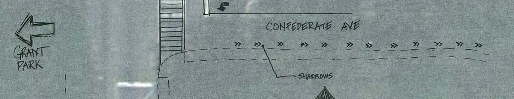
25 Map Key Location Need Recommended treatment Team Priority Short Timeframe Mid Long Option 1: Confederate Avenue and Boulevard Relatively high traffic volumes were observed on Confederate Avenue during school arrival and dismissal hours. Additionally, motor vehicles are permitted a right turn on red from Confederate onto Boulevard. Lower traffic speeds and fewer turning conflicts will improve the safety and comfort of this bicycle connection. Recommendation: Conduct a traffic study to deine feasibility of reducing cut-through traffic on Confederate Avenue by restricting access from Moreland Avenue. If traffic is reduced: Explore restricting right turn on red and install Bicycles may use full lane signs at intersection. Adjust traffic signal timing to accommodate through traffic bike movement. High PAGE 25
26 Map Key Location Need Recommended treatment Team Priority Short Timeframe Mid Long Option 2: Berne Street and Boulevard Relatively low traffic volumes were observed on Berne Street during school arrival and dismissal hours. Additionally, right turn on red is currently restricted from Berne onto Boulevard. The offset intersection creates a wide exposure area for bicyclists traveling east-west through the intersection. Recommendation: Establish a bicycle and pedestrian connection directly into Grant Park. Install high visibility crosswalks across the Boulevard from the east side of Berne Street. Install shared-use path connecting the existing sidewalk along the west side of Boulevard to the existing road within the park (note: the road is closed to motor vehicles). The head of the path (at intersection with sidewalk) should be widened to create a landing area for bicyclists. Install curb ramps and pedestrian signals at new marked crosswalks. Note: Bicyclists would be directed to cross at the crosswalks, therefore signs indicating that cyclists should dismount may be appropriate. High PAGE 26
27 Timeframe Map Key Location Need Recommended treatment Team Priority Short Mid Long J Confederate Avenue between Ormewood and Boulevard Some of the students bicycling to school from west of Grant Park cross Boulevard at Confederate Avenue and travel on Confederate to and from Ormewood to get to the school. Relatively high traffic volumes were observed on Confederate Avenue during school arrival and dismissal hours. Recommendation Summary Improve bicycle facilities and signage to alert drivers to presence of bicyclists. Install shared lane markings on Confederate Avenue heading east between Boulevard and Ormewood. Install 5-ft bike lane on Confederate Avenue heading west between Ormewood and Boulevard. High Install Bicycles may use full lane (R4-11) to alert drivers to presence of bicyclists. K Berne Street and Ormewood Avenue between Woodland and Boulevard Ormewood Avenue and Berne Street between Woodland and Boulevard are commonly used routes for families bicycling from the east side of Moreland or from Atlanta Charter Middle School to and from Neighborhood Charter School. Current road width on both roads allows for improved bicycle facilities, and several options are possible. Recommendation Summary While not feasible within the scope of this SRTS planning project, it is recommended that the community further pursue the development of a plan to improve the bicycle infrastructure on Ormewood Avenue and Berne Street between Woodland Avenue and Boulevard. PAGE 27
28 Timeframe Map Key Location Need Recommended treatment Team Priority Short Mid Long As an interim solution to improve driver awareness of bicyclists on these roads, install shared lane markings. L Areas within school zone The school is located off of a small sidestreet in a densely populated residential neighborhood. Drivers may not be fully aware that they are traveling through a school zone. Recommendation Summary Install additional signage to enhance visibility of zone. Evaluate and install additional school zone signage to alert drivers of school zone. Medium M Areas within school zone While current pedestrian infrastructure exists in the immediate area, several sidewalks are in need of maintenance. Recommendation Summary Provide spot maintenance to keep sidewalks in good repair. Low Evaluate and provide spot maintenance on sidewalks in need of repair. PAGE 28
29 APPENDI A: Georgia Safe Routes to School Program: Non-engineering Strategies Strategy E s Advantages Considerations Resources Walking and Biking Safety Assembly These single day events can be held in the fall to promote Walk to School Day. Guest speakers teach the students pedestrian and bicycle safety skills that they can use when walking and biking to school. Education, Encouragement Assures all children learn bicycle and pedestrian safety skills Establishes habits that benefit children throughout their lives, regardless of whether they currently walk or bike to school Establishes consistent messages for young pedestrians and bicyclists Provides a refresher for parents if take home materials are provided in conjunction with the assembly. It s never too late to correct bad habits. Events can make learning fun, and help strengthen community ties with event organizers and participants. Best taught using a combination of methods, including one time instruction (e.g. assemblies), multi lesson classroom curricula, and skills practice (e.g. bike rodeos). Requires able and willing instructors Should be age appropriate Bicycle safety education may require an outside instructor, e.g. a police officer. NCSRTS page on strategies for educating children: rategies_for_educating_children.cfm National Highway Transportation Administration s pedestrian page: item.dfedd570f698cabbbf a0c/ Safe Kids pedestrian safety page: League of American Bicyclists education programs page: PAGE 29
30 Strategy E s Advantages Considerations Resources Participate in Walk to School Day Walk to School Day is a one day event that celebrates walking and biking to school. Generally this event is scheduled for the first full week in October. The State of Georgia hosts a Spring Walk to School Day in March. Frequent Walker/Bicyclist Program or Walking Wednesdays Track and reward students who walk and bicycle to school. Can be an individual competition or a competition among classes. Education, Encouragement Encouragement Excellent kick off event for Safe Routes to School program Generates enthusiasm for walking and biking Way to raise community awareness about safety issues Can be as simple as a few kids and parents meeting to walk to school or very elaborate celebrations Can be folded into studies of international cultures as it is an international event Date is flexible to be counted by the National Center for Safe Routes to school the event need only take place before Dec 1. Provides positive reinforcement for walking and bicycling. Children respond to incentives. Can include all students. Can include walking and bicycling beyond the trip to school. Preparations for elaborate celebrations must begin several months in advance to allow time to identify partners, plan activities, and promote the event Should provide bicycle and pedestrian safety information to children and parents International Walk to School Day takes place in October but some schools organize multiple Walk to School Day (or Walk and Roll Day ) events over the course of the school year (e.g. one in the fall and one in the spring). Necessary to identify a coordinator. Establish a simple record keeping system. Establish age appropriate goals. Consider giving rewards to parents as well, since parents are often involved in the commute to school. Walk to School Day downloadable templates for flyers, banners, pennants, etc: U.S. Walk to School Day website (provides resources and event registration): International Walk to School Day website: Resources for Georgia s Way to Go Program Resources such as downloadable templates for punch cards and stickers: oads NCSRTS page on mileage clubs and contests: t/mileage_clubs_and_contests.cfm Participate in Georgia s Way to Go Program. PAGE 30
31 Strategy E s Advantages Considerations Resources Traffic Enforcement (Staff/Crossing Guards) This can be an ongoing program for school staff and crossing guards. This works well if the school has an existing reward point program. Education, Enforcement, Encouragement Crossing guards play an important role in helping children cross the street at key locations, reminding drivers of the presence of pedestrians, and making parents feel more comfortable about letting their children walk and bicycle to school. Staff and crossing guards can also reward students who are caught being good by issuing School Reward Points. Requires some training and coordination with crossing guards Student Safety Patrol Program This can be an ongoing program for 5th grade students. Student safety patrols can offer educational literature to offenders to let them know about traffic safety issues (and proper behavior) surrounding the school zone. Education, Enforcement, Encouragement Students can also issue citations if condoned by the school. Excellent way to educate parents and encourage appropriate behaviors while supporting the school s SRTS program. Teaches students valuable leadership skills. Requires an adult organizer such as a parent, teacher, or law enforcement officer Materials such as sashes and badges are encouraged Requires adult supervision while students are on duty Student safety patrols will also be trained to set the model example for younger students. In the last month of school, student patrols can train 3rd graders who are interested in being trained in the fall. One option is to host an end of the year party to honor the graduating safety patrols Giveaways for students when they cash in their Reward points AAA Safety Patrol Program: Foundation/ SchoolPrograms/SchoolSafetyPatrol PAGE 31
32 Strategy E s Advantages Considerations Resources Bike Rodeo This is a single day event that promotes bicycle safety. At the rodeo, students can borrow bicycles or bring their own. Walk Audit/Parent Surveys / Student tallies The team will meet annually (ideally in August before school starts) to review the accomplishments and progress from the previous school year and set new goals for the upcoming school year. Education, Encouragement Evaluation Events like bike rodeos make learning fun and can help strengthen community ties with event organizers and participants. At the rodeo students learn safety skills such as how to properly wear a helmet and how to behave while bike riding. The rodeo can also have a closed test course for the students to ride along. This helps the students to practice in a safe environment and gain confidence in their decisionmaking skills. One possible partner for this is the local police department. Establishes baseline information on student travel behavior and perceived barriers to walking and biking Helps deine existing needs Helps deine success of SRTS efforts and identify needed adjustments Requires able and willing instructors Should be age appropriate Bicycle safety education may require an outside instructor, e.g. a police officer. These events require planning and materials to share with students Best to conduct initial surveys before SRTS measures have been implemented Requires teacher buy in and administrative organization Getting parents to fill out and return surveys can be a challenge. Follow up is necessary. Consider a contest among classes for highest rate of return. Bicycling Life page on bicycle rodeos: kills/bicyclerodeo.htm Student In Class Travel Tally Form: evaluation_student in class traveltalley.cfm Parent Survey Form: evaluation_parent survey.cfm Instructions for Survey Administration: evaluation_instructions.cfm Instructions for Data Entry: evaluation_cover sheets.cfm PAGE 32
33 Strategy E s Advantages Considerations Resources Walking School Buses/ Bicycle Trains Walking school buses and bicycle trains are adult supervised groups of students walking and/or bicycling to school. Education, Encouragement Adult supervision on the walk to school Can be loosely structured or highly organized Can include a meeting point in a parking lot so children and parents who must drive can participate. Adults can rotate who will lead each time. Need to identify routes where conditions support walking and there is sufficient demand for supervised walking Requires parents willing to walk with children and learn about how Walking school buses are organized and conducted. More organized structure requires considerable planning NCSRTS page on walking school buses: ouragement/walking_school_bus_ or_bicycle_train.cfm Drive Safe Campaigns Some parents are not aware of how their driving behavior can put walking students at risk. This teaches parents how their unsafe driving habits can put their children in danger. Education Has the ability to positively effect change in and community around the school Improves the safety of the walking environment Good drivers can help to set the example for good behavior. This is especially true for helping to control speeds. This requires a person to organize and administer the campaign. May not be effective at schools where parent/teacher organizations are weak Law enforcement officers would be great at speaking at the campaign events. Sometimes, due to their heavy schedules that can be difficult to pin down. A good way to contact parents is at back to school night and PTA meetings. Starting at the beginning of the year helps to prevent bad habits from starting. Law enforcement officers (or other teachers) can hold a brief assembly to explain the dangers of unsafe driving in school areas. Law enforcement officers can provide a demonstration of how difficult it is to quickly stop a moving vehicle at 50, 40 and 30 mph. The National Center has information on how the speed of the vehicle can affect the severity of injury that the pedestrian experiences in a crash. PAGE 33
34 Strategy E s Advantages Considerations Resources Crossing Guard Appreciation Day Crossing guards help our children cross the road safely in the mornings and afternoons, in all weather conditions. Remind them that you appreciate their service and dedication. Students can create thank you cards that they deliver themselves during their walks home, or teachers and administrators can honor them formally during a school assembly. Encouragement Maintains a positive relationship between the crossing guards and the school/community. Can inspire crossing guards to continue to be reliable, safety figures. Creates an opportunity to remind students why it is important to practice safe walking skills. Requires coordination between the crossing guards, school administrators and school instructors. May require materials to create the thank you cards. Is most effective with newsletter and in school announcements. Relatively inexpensive strategy Downloadable templates for event flyers and newsletter inserts: esources/downloads PAGE 34
35 Strategy E s Advantages Considerations Resources Pace Car Program Program participants pledge to drive the speed limit on neighborhood streets, respect pedestrians and bicyclists, and display the Pace Car bumper sticker. Enforcement Low cost way to slow traffic and improve interactions between motorists, pedestrians, and bicyclists Must be accompanied by an education and outreach campaign Need to find funding source for stickers and other materials Not all drivers who make the pledge will keep it, but the program can still be effective if enough people do Can have students design logo as part of contest Websites for Pace Car programs around the country: cruz.ca.us/pw/npcp/npcp.html cityofdavis.org/police/pacecar/ Adopt a Sidewalk Program To keep sidewalks clear of debris and trash, groups can volunteer to adopt a sidewalk. Groups can include classrooms and families as well as local businesses or agencies. Education This promotes the Safe Routes to School program and also relieves the localities of some of the burden to keep the sidewalks well maintained. Requires the help and dedication of volunteers Requires public outreach and education PAGE 35
36 Georgia based Organizations Working to Support Safe Routes to School Georgia Bikes! ( GEORGIA BIKES! Is a statewide organization working to improve bicycling conditions and promote bicycling in Georgia. Their work includes creating a law enforcement officer's pocket guide, instigating school based education efforts and developing bicyclist education materials. Atlanta Bicycle Coalitions ( ABC's mission is to make it safer and easier for people to ride bicycles by advocating for better facilities for bicycles, educating cyclists and drivers on sharing the road safely, offering programs to support those who would like to start biking as well as those who already bike to ride more often, and by promoting the bicycle as a both a viable transportation solution and a community building form of recreation and exercise. PEDS ( PEDS is a nonprofit, member based advocacy organization dedicated to making metro Atlanta safe and accessible for all pedestrians. Members work to improve engineering of the pedestrian environment, increase enforcement of pedestrian safety and educate drivers about their responsibilities to pedestrians. Alliance for a Healthier Generation ( The Alliance for a Healthier Generation is a Georgia SRTS Network Partner that can provide support to schools through its Healthy Schools Program. American Heart Association (AHA) ( The AHA (also a Georgia SRTS Network Partner) is a strong supporter of the Safe Routes to School Program. Georgia Regional Commissions Georgia's regional commissions are organizations comprised of county and municipal governments providing services in the areas of planning (including transportation planning), public administration, economic development, aging services and information technology. Central Savannah River Area Regional Commission ( Coastal Georgia RC ( Georgia Mountains RC ( Heart of Georgia RC ( Middle Georgia RC ( Northeast Georgia RC ( Northwest Georgia RC ( River Valley RC ( Southern Georgia RC ( Southwest Georgia Regional Commission ( Three Rivers RC ( Atlanta Regional Commission ( PAGE 36


37 APPENDI B: Conceptual Drawings for Select Engineering Recommendations Map Key A: Intersection of Essie Avenue and Emerson Avenue PAGE 37
38 Map Key E, F, G: Ormewood Avenue from Woodland through intersection with Moreland and toward Flat Shoals PAGE 38


39 Map Key I, Option 1: Confederate Avenue and Boulevard PAGE 39
Broad Street Bicycle Boulevard Design Guidelines
 Broad Street Bicycle Boulevard Design Guidelines Building from the strategies introduced in the 2013 Bicycle Transportation Plan and community input received thus far, City Transportation Staff have identified
Chapter 2. Bellingham Bicycle Master Plan Chapter 2: Policies and Actions
 Chapter 2 Bellingham Bicycle Master Plan Chapter 2: Policies and Actions Chapter 2: Policies and Actions The Bicycle Master Plan provides a road map for making bicycling in Bellingham a viable transportation
C/CAG. Sunnybrae Elementary School Walking and Bicycling Audit. San Mateo-Foster City School District JUNE 2013
 Sunnybrae Elementary School Walking and Bicycling Audit JUNE 2013 San Mateo-Foster City School District C/CAG City/County Association of Governments of San Mateo County SUNNYBRAE ELEMENTARY SCHOOL WALKING
July 5, Arthur R. Ware, Jr. Elementary School 2017 Safe Routes to School Walkabout Report
 July 5, 2017 Arthur R. Ware, Jr. Elementary School 2017 Safe Routes to School Walkabout Report 1 Walkabout Report Introduction On April 28, 2017, City, School, and SAWMPO staff met to conduct a Safe Routes
CITY OF OAK CREEK SAFE ROUTES TO SCHOOL ACTION PLAN. East Middle School
 CITY OF OAK CREEK SAFE ROUTES TO SCHOOL ACTION PLAN East Middle School CITY OF OAK CREEK SAFE ROUTES TO SCHOOL ACTION PLAN East Middle School Why Safe Routes to School? Safe Routes to School ( SRTS ) is
Agenda. Overview PRINCE GEORGE S PLAZA METRO AREA PEDESTRIAN PLAN
 PRINCE GEORGE S PLAZA METRO AREA PEDESTRIAN PLAN May 28, 2008 Agenda Welcome and introductions Project overview and issue identification Planning context and strengths Design challenges and initial recommendations
Bringing together community and health. Physical Activity and Nutrition Unit Office of Statewide Health Improvement Initiatives
 Bringing together community and health. Physical Activity and Nutrition Unit Office of Statewide Health Improvement Initiatives Physical Activity and Nutrition Unit Office of Statewide Health Improvement
Safe Routes to School Guide
 Safe Routes to School Guide Steps to Creating a Safe Routes to School Program Created February 2007 SafeRoutes National Center for Safe Routes to School This guide was developed by the Pedestrian and Bicycle
REGIONAL BICYCLE AND PEDESTRIAN DESIGN GUIDELINES
 REGIONAL BICYCLE AND PEDESTRIAN DESIGN GUIDELINES November 16, 2011 Deb Humphreys North Central Texas Council of Governments Bicycle and Pedestrian Advisory Committee Snapshot of the Guide 1. Introduction
Safe Routes to School Action Plan Aberdeen, Idaho
 Background Aberdeen, Idaho is a largely agricultural community of nearly 2,000 people and is located in the southeast portion of the state on the western edge of American Falls Reservoir. The community
Why Zone In on Speed Reduction?
 Learn it. Do it. Live it! SPEED REDUCTION IN THE ZONE Why Zone In on Speed Reduction? Speeding is a serious issue that plays a major role in the risk of serious injury and pedestrian fatality in a crash.
2 Mark Twain Elementary School Report
 2 Mark Twain Elementary School Report Principal: Greg Kaatz Grades: K-2 Enrollment: 323 Address: 425 N. Church Street First bell: 8:10 a.m. Silverton, OR 97381 Last bell: 2:30 p.m. Free & Reduced Lunch:
SAFE ROUTES TO SCHOOL
 SAFE ROUTES TO SCHOOL Forest Ridge Elementary School Existing Conditions and ACTION PLAN > Oak Creek - Franklin Joint School District Table of Contents CONTEXT Enrollment Boundaries
SAFE ROUTES TO SCHOOL
 SAFE ROUTES TO SCHOOL Edgewood Elementary School Existing Conditions and ACTION PLAN > Oak Creek - Franklin Joint School District Table of Contents CONTEXT Enrollment Boundaries Enrollment
Vallecito Elementary School. Travel Plan
 Vallecito Elementary School Travel Plan TABLE OF CONTENTS 1. PURPOSE... 1 1.1. SR2S PLANNING, IMPLEMENTATION AND MONITORING... 1 1.2. MARIN COUNTY MEASURE A... 1 2. VALLECITO ELEMENTARY SCHOOL PROFILE...
Introduction.
 2307-1.0. Introduction. Delaware s Safe Routes to School (SRTS) Program was established September 10, 2002 when Governor Ruth Ann Minner signed Senate Bill 353 of the 141st General Assembly of Delaware
BIKE PLAN CONTENTS GATEWAY
 CONTENTS Acknowledgments...vii Great Rivers Greenway District Board of Directors... vii Great Rivers Greenway District Staff... vii Project Consultants... vii Committees... viii Citizens Advisory Committee
Appendix C. TRAFFIC CALMING PROGRAM TOOLBOX
 Appendix C. TRAFFIC CALMING PROGRAM TOOLBOX PHASE I...2 Do Not Enter Sign...3 One-Way Sign...4 Turn Prohibition...5 Pavement Markings...6 Speed Monitoring Trailer...7 Neighborhood Speed Watch...8 Police
Chapter 3.9 Timbercrest Elementary School. Volusia County MPO. November 2008
 Chapter 3.9 Timbercrest Elementary School Deltona, FL Volusia County MPO November 2008 Volusia County MPO School Bicycle and Pedestrian Review Study, Phase 3B School Summary Timbercrest Elementary School
PRINCE GEORGE S PLAZA METRO AREA PEDESTRIAN PLAN
 PRINCE GEORGE S PLAZA METRO AREA PEDESTRIAN PLAN May 28, 2008 Agenda Welcome and introductions Project overview and issue identification Planning context and strengths Design challenges and initial recommendations
Residential Traffic Calming Program Guide. Town of Ashland, Virginia
 Residential Traffic Calming Program Guide Town of Ashland, Virginia August 1, 2006 TABLE OF CONTENTS A. INTRODUCTION... 1 B. GOALS... 1 C. CRITERIA... 1 D. IDENTIFYING NEIGHBORHOOD TRAFFIC CONCERNS...
Bikeway action plan. Bicycle Friendly Community Workshop March 5, 2007 Rochester, MN
 Bikeway action plan Summary The was held on March 5, 2007 at the Rochester Mayo Civic Center. The workshop was hosted by Rochester-Olmsted County Planning Department in collaboration with the League of
About the Studio. Edward J. Bloustein School of Planning and Public Policy - Rutgers University
 About the Studio Edward J. Bloustein School of Planning and Public Policy - Rutgers University Purpose of studio: Help City of Bayonne apply for Safe Routes to School (SRTS) funding by producing a School
Bicycle Facilities Planning
 Bicycle Facilities Planning Overview Types of Cyclists Purpose for Riding Types of Facilities Bike Lanes Bicycle Boulevards Cycle Tracks Intersections Signals Signing and Marking Discussion Types of Bicyclists
PEDESTRIAN ACTION PLAN
 ATTACHMENT 2 CITY OF SANTA MONICA PEDESTRIAN ACTION PLAN CITY OF SANTA MONICA PEDESTRIAN ACTION PLAN This page intentionally left blank EXECUTIVE SUMMARY CHAPTER 1 EXECUTIVE SUMMARY Setting the Stage
Chapter 3.3 Horizon Elementary School. Volusia County MPO. June 2009
 Chapter 3.3 Horizon Elementary School Port Orange, FL Volusia County MPO June 2009 Volusia County MPO School Bicycle and Pedestrian Review Study, Phase 3C School Summary Horizon Elementary School is located
Environment and Public Works Committee Presentation
 Mixed Use Centers Complete Streets Guidelines Project Environment and Public Works Committee Presentation December 10, 2008 Project Objectives: Conduct an inter-departmental and agency process to study
5. RUNNINGWAY GUIDELINES
 5. RUNNINGWAY GUIDELINES These guidelines should be considered collectively when making runningway decisions. A runningway is the linear component of the transit system that forms the right-of-way reserved
CHAPTER 3: Vision Statement and Goals
 Davidson Walks & Rolls: Active Transportation Master Plan CHAPTER 3 Contents: Overview Vision Statement Measurable Goals Public Outreach CHAPTER 3: Vision Statement and Goals Overview The vision statement
3 Silverton High School Report
 3 Silverton High School Report Principal: Justin Lieuallen Grades: 9-12 Enrollment: 1,277 Address: 1456 Pine Street First bell: 7:55 a.m. Silverton, OR 97381 Last bell: 3:05 p.m. Free & Reduced Lunch:
OCEAN DRIVE ELEMENTARY SCHOOL
 OCEAN DRIVE ELEMENTARY SCHOOL North Myrtle Beach, SC Safe Routes to School Travel Plan JANUARY 2017 SRTS Team Roster SRTS Team members represent key community stakeholders, share work of developing the
CITY MANUALS AND STANDARDS REVIEW
 GEORGETOWN SIDEWALK MASTER PLAN CITY MANUALS AND STANDARDS REVIEW RESOURCES AND STANDARDS As part of the Master Plan process, a review and evaluation of current City documents and policies relevant to
Safe Routes to School in New Jersey
 Safe Routes to School in New Jersey The need for Safe Routes to School 1. Fewer kids today walk and bike to school 2. Unintended consequences have resulted 3. SRTS programs can be part of the solution
Wellington Exempted Village School District SAFE ROUTES TO SCHOOL TRAVEL PLAN January 2014
 Wellington Exempted Village School District SAFE ROUTES TO SCHOOL TRAVEL PLAN January 2014 OHIO SAFE ROUTES TO SCHOOL WELLINGTON EXEMPTED VILLAGE SCHOOL DISTRICT TRAVEL PLAN SECTION 1: WELLINGTON EXEMPTED
Coquitlam Cross-town Bike Route Improving Bicycle Facilities in a Mature Suburban Environment
 Coquitlam Cross-town Bike Route Improving Bicycle Facilities in a Mature Suburban Environment Sarah Rocchi, Vice-President, Projects, Opus International Consultants (Main Presenter) Catherine Mohoruk,
Corpus Christi Metropolitan Transportation Plan Fiscal Year Introduction:
 Introduction: The Safe, Accountable, Flexible, Efficient Transportation Equity Act: A Legacy for Users (SAFETEA-LU) has continued the efforts started through the Intermodal Surface Transportation Efficiency
EXECUTIVE SUMMARY. Vision
 Vision Walking and bicycling in Salt Lake City will be safe, convenient, comfortable, and viable transportation options that connect people to places, foster recreational and economic development opportunities,
TRAFFIC CALMING TOOLBOX. For the residents of the City of Decatur, Georgia
 TRAFFIC CALMING TOOLBOX For the residents of the City of Decatur, Georgia 2 City of Decatur Traffic Calming Toolbox Public Works Department 2635 Talley Street Decatur, GA 30030 404.377.5571 3 Welcome to
City of Wilsonville 5 th Street to Kinsman Road Extension Project
 City of Wilsonville 5 th Street to Kinsman Road Walking Tour & Neighborhood Workshop Summary Report Public Outreach Overview On July 18 th, 2017, the City of Wilsonville hosted a neighborhood walking tour
TOWN OF PORTLAND, CONNECTICUT COMPLETE STREETS POLICY
 TOWN OF PORTLAND, CONNECTICUT COMPLETE STREETS POLICY I. VISION, GOALS & PRINCIPLES VISION To improve the streets of Portland making them safer and more accessible for all users including pedestrians,
Active Transportation Facility Glossary
 Active Transportation Facility Glossary This document defines different active transportation facilities and suggests appropriate corridor types. Click on a facility type to jump to its definition. Bike
Mary H Wright Elementary School
 Mary H Wright Elementary School Safe Routes to School Travel Plan February Prepared with assistance from the SC SRTS Resource Center INTRODUCTION This Travel Plan represents the work of the Mary H. Wright
Complete Streets. Designing Streets for Everyone. Sarnia
 Complete Streets Designing Streets for Everyone Sarnia Complete Streets ~ Sarnia ~ 2018 Introduction Our City is made up of a network of streets that we use to go for a walk, cycle to work, drive to the
City of Elizabeth City Neighborhood Traffic Calming Policy and Guidelines
 City of Elizabeth City Neighborhood Traffic Calming Policy and Guidelines I. Purpose: The City of Elizabeth City is committed to ensure the overall safety and livability of residential neighborhoods. One
CONNECTING PEOPLE TO PLACES
 CONNECTING PEOPLE TO PLACES 82 EAST BENCH MASTER PLAN 07 Introduction The East Bench transportation system is a collection of slow moving, treelined residential streets and major arteries that are the
Mountain View Elementary School
 Mountain View Elementary School Safe Routes to School Travel Plan August 2016 3448 Sandy Plains Road Marietta, Georgia Prepared with assistance from the Georgia SRTS Resource Center Table of Contents Acknowledgements...
Non-Motorized Transportation 7-1
 Non-Motorized Transportation 7-1 Transportation facilities no longer mean just accommodating a vehicle powered by a combustion engine. Pedestrian and non-motorized facilities are important modes of travel
AGENDA. 5. Next Steps a. Survey Distribution b. Draft Action Plan/Recommendations c. Review at next meeting in advance of document preparation
 Congdon Elementary Safe Routes to School Plan Update SRTS Team Meeting #2-Walk Audit March 21, 2018, 3:00 p.m. Congdon Elementary School Art Room-Duluth, MN 1. Welcome and Introductions 2. SRTS Review
THE OFFICIAL GUIDE TO CYCLING SAFELY IN PHILADELPHIA
 B IKE NICE THE OFFICIAL GUIDE TO CYCLING SAFELY IN PHILADELPHIA A partnership of the City of Philadelphia and the Bicycle Coalition of Greater Philadelphia ABOUT VISION ZERO & BIKE NICE It s a great day
APPENDIX A: Complete Streets Checklist DRAFT NOVEMBER 2016
 APPENDIX A: Complete Streets Checklist DRAFT NOVEMBER 2016 Complete Streets Checklist MetroPlan Orlando s Complete Streets Checklist is an internal planning tool for staff to further implementation of
TRAFFIC CALMING GUIDE FOR TORONTO CITY OF TORONTO TRANSPORTATION SERVICES DIVISION
 TRAFFIC CALMING GUIDE FOR TORONTO CITY OF TORONTO TRANSPORTATION SERVICES DIVISION CITY OF TORONTO TRANSPORTATION SERVICES DIVISION 2016 TRAFFIC CALMING GUIDE FOR TORONTO TABLE OF CONTENTS Introduction
1.0 EXECUTIVE SUMMARY
 1.0 EXECUTIVE SUMMARY The Active Transportation Plan is a guide to accomplish the Town s vision for developing a network of sidewalks, on-road bicycle facilities, and trails that allow for safe and convenient
Getting Your SRTS Project Funded. Ryan Snyder
 Getting Your SRTS Project Funded Ryan Snyder Steps in Submitting a Successful Application 1. Stakeholder outreach: create a SRTS coalition 2. Develop a comprehensive plan and program with all 5 Es 3. Conceive
Walkabout Summary Report
 Walkabout Summary Report Introduction On September 3, 2014, stakeholders at Bessie Weller Elementary School (Bessie Weller ES) in Staunton, Virginia met to examine the walking and bicycling network around
WALKSacrame nto. Welcomes you to the 2009 Sacramento County Safe Routes to School Conference
 Sacramento County Department of Transportation Ron Vicari, Principal Civil Engineer In Partnership with: WALKSacrame nto Anne Geraghty, Terry Preston & Staff Welcomes you to the 2009 Sacramento County
PBIC Webinar. How to Create a Bicycle Safety Action Plan: Planning for Safety [IMAGE] Oct. 2, 2014, 2 pm
![PBIC Webinar. How to Create a Bicycle Safety Action Plan: Planning for Safety [IMAGE] Oct. 2, 2014, 2 pm](/thumbs/86/93953441.jpg "PBIC Webinar. How to Create a Bicycle Safety Action Plan: Planning for Safety [IMAGE] Oct. 2, 2014, 2 pm") PBIC Webinar How to Create a Bicycle Safety Action Plan: Planning for Safety [IMAGE] Bill Schultheiss, Vice President, Toole Design Peter Lagerwey, Regional Director, Toole Design Oct. 2, 2014, 2 pm Today
PBIC Webinar How to Create a Bicycle Safety Action Plan: Planning for Safety [IMAGE] Bill Schultheiss, Vice President, Toole Design Peter Lagerwey, Regional Director, Toole Design Oct. 2, 2014, 2 pm Today
Off-road Trails. Guidance
 Off-road Trails Off-road trails are shared use paths located on an independent alignment that provide two-way travel for people walking, bicycling, and other non-motorized users. Trails specifically along
TRAVEL PLAN: CENTRAL EUROPEAN UNIVERSITY CAMPUS REDEVELOPMENT PROJECT TRAVEL PLAN. Central European University Campus Redevelopment Project.
 TRAVEL PLAN Central European University Campus Redevelopment Project Page 1 Table of Contents Introduction... 3 Background... 7 Building Users... 7 Transportation in Community Consultation... 7 Summary
City of Novi Non-Motorized Master Plan 2011 Executive Summary
 City of Novi Non-Motorized Master Plan 2011 Executive Summary Prepared by: February 28, 2011 Why Plan? Encouraging healthy, active lifestyles through pathway and sidewalk connectivity has been a focus
MAG Town of Cave Creek Bike Study Task 6 Executive Summary and Regional Significance Report
 Page 1 MAG Town of Cave Creek Bike Study Task 6 Executive Summary and Regional Significance Report August 1, 2012 MAG Project #481 Page 2 Task 6 Executive Summary and Regional Significance Report Introduction
Bicycle Master Plan Goals, Strategies, and Policies
 Bicycle Master Plan Goals, Strategies, and Policies Mobilizing 5 This chapter outlines the overarching goals, action statements, and action items Long Beach will take in order to achieve its vision of
CITY OF VISTA TRAFFIC CALMING PROGRAM
 CITY OF VISTA TRAFFIC CALMING PROGRAM The purpose of the Vista Traffic Calming Program is to reduce speeds of motorists driving through residential neighborhoods. The program does not apply to nonresidential
Town of Mooresville, North Carolina Neighborhood Traffic Calming and Control Device Policy
 Town of Mooresville, North Carolina Neighborhood Traffic Calming and Control Device Policy Adopted January 6, 2014 Town of Mooresville Development Services Department TOWN OF MOORESVILLE NEIGHBORHOOD TRAFFIC
Settles Bridge Elementary School Safe Routes to School Travel Plan
 Settles Bridge Elementary School Safe Routes to School Travel Plan 600 James Burgess Road Suwanee, GA 30024 February 2012 PAGE 1 BETHUNE ELEMENTARY SCHOOL TRAVEL PLAN Table of Contents Table of Contents...
CITY OF BLOOMINGTON COMPLETE STREETS POLICY
 CITY OF BLOOMINGTON COMPLETE STREETS POLICY POLICY OBJECTIVE: The City of Bloomington will enhance safety, mobility, accessibility and convenience for transportation network users of all ages and abilities,
SAN FRANCISCO MUNICIPAL TRANSPORTATION AGENCY
 THIS PRINT COVERS CALENDAR ITEM NO. : 10.2 DIVISION: Sustainable Streets BRIEF DESCRIPTION: SAN FRANCISCO MUNICIPAL TRANSPORTATION AGENCY Adopting Conceptual Proposal for Streetscape Improvements to Broadway,
Barnum- Safe Routes to School Meeting #2 January 20, 2015
 Barnum- Safe Routes to School Meeting #2 January 20, 2015 1. Introductions 2. SRTS Program Overview 1. Purpose 2. Benefits 3. Background of planning Process 3. Existing Conditions Review and Summary 1.
Omaha s Complete Streets Policy
 Omaha s Complete Streets Policy (Adopted August 2015) VISION To create great places and enhance our quality of life, the City of Omaha will provide safe, accessible streets for all users. Complete Streets
Living Streets Policy
 Living Streets Policy Introduction Living streets balance the needs of motorists, bicyclists, pedestrians and transit riders in ways that promote safety and convenience, enhance community identity, create
General Design Factors
 Chapter 3: 3-1.0 Introduction General Design Factors Mn/DOT s goals include encouraging and accommodating safe bicycling. From a design perspective, these goals are achieved by first having an understanding
Madison Urban Area and Dane County. Bicycle Transportation Plan Summary. September Introduction. Bicycle Plan Scope and Planning Process
 Bicycle Transportation Plan Summary Madison Urban Area and Dane County Introduction September 2000 Bicycling is an important mode of transportation in the Madison urban area and countywide that is available
CITY OF KASSON TRANSPORTATION ALTERNATIVES KASSON SAFE ROUTES TO SCHOOL
 ve ha 8t G B A Mantorville Ave N 240th Ave 16th St NE 11th Ave NE K-M HIGH SCHOOL SUNRISE TRAIL TO MANTORVILLE MNTH 57 SUNSET TRAIL TO MANTORVILLE NE PARK 16TH ST NE TRAIL K-M ELEMENTARY SCHOOL K-M MIDDLE
NM-POLICY 1: Improve service levels, participation, and options for non-motorized transportation modes throughout the County.
 Transportation PRINCE WILLIAM COUNTY 2008 COMPREHENSIVE PLAN NON-MOTORIZED PLAN CONTENTS Goals, Policies, and Action Strategies Table 4 (Bike Facility Classifications and Descriptions) Table 5 (Bike Facility
Improve the livability of our streets by
 Pedestrian and Traffic Calming Policy March 2018 2 of 6 Neighborhood Traffic Calming Policy The City of Aspen continually strives to protect multimodal function while maintaining a high standard of safety.
What is non-infrastructure?
 Non-Infrastructure What is non-infrastructure? Education Encouragement Enforcement Evaluation Education Who needs educational messages? 1. Children 2. Parents 3. Neighbors 1. Educating children Pedestrian
SAN FRANCISCO MUNICIPAL TRANSPORTATION AGENCY
 THIS PRINT COVERS CALENDAR ITEM NO.: 10.3 DIVISION: Sustainable Streets BRIEF DESCRIPTION: SAN FRANCISCO MUNICIPAL TRANSPORTATION AGENCY Approving various traffic and parking modifications on Bay Street
County of Greenville South Carolina. Traffic Calming Program Neighborhood Traffic Education Program and Speed Hump Program
 County of Greenville South Carolina Traffic Calming Program Neighborhood Traffic Education Program and Speed Hump Program (rev) August 2008 I. PURPOSE The potential negative impacts from vehicular traffic
FEDERAL HIGHWAY ADMINISTRATION APPLICATION
 FEDERAL HIGHWAY ADMINISTRATION APPLICATION REQUEST FOR PERMISSION TO EXPERIMENT WITH A BICYCLE BOX INTERSECTION TREATMENT Submitted by: City of Columbus Department of Public Service Date: June 26, 2009
MONTCLAIR SAFE COMPLETE STREETS IMPLEMENTATION PLAN. Monday November 13, 2017 Michael Dannemiller, Principal Engineer NV5, Inc.
 MONTCLAIR SAFE COMPLETE STREETS IMPLEMENTATION PLAN Monday November 13, 2017 Michael Dannemiller, Principal Engineer NV5, Inc. PROJECT TEAM THE OFFICE OF BICYCLE AND PEDESTRIAN PROGRAMS, NEW JERSEY DEPARTMENT
SRTS IMPLEMENTATION COSTS
 SRTS IMPLEMENTATION COSTS What Is a Estimate? A cost estimate establishes the anticipated budget required to implement the actions (the improvement projects and programs) identified in your School Travel
HARRISON STREET/OAKLAND AVENUE COMMUNITY TRANSPORTATION PLAN
 HARRISON STREET/OAKLAND AVENUE Community Workshop #4: Draft Plan Review December 3, 2009 D E S I G N, C O M M U N I T Y & E N V I R O N M E N T INTRODUCTIONS Key Project Staff: Alisa Shen, Project Manager,
Tonight is for you. Learn everything you can. Share all your ideas.
 Strathcona Neighbourhood Renewal Draft Concept Design Tonight is for you. Learn everything you can. Share all your ideas. What is Neighbourhood Renewal? Creating a design with you for your neighbourhood.
Caltrans Sloat Boulevard Pedestrian Safety Project Response to Community Questions, Comments & Concerns
 Caltrans Sloat Boulevard Pedestrian Safety Project Response to Community Questions, Comments & Concerns Revised: May 10, 2016 The California Department of Transportation (Caltrans) is planning various
G AT E WAY PLAN. Community BRIEFING KIT GATEWAY BIKE
 G AT E WAY PLAN GATEWAY BIKE Community BRIEFING KIT PLAN August 2016 TABLE OF CONTENTS INTRODUCTION... 1 THE BENEFITS OF A BIKEABLE COMMUNITY... 2 ECONOMY...2 SAFETY...3 HEALTH...3 HOUSEHOLD SPENDING...3
FLORIDA DEPARTMENT OF TRANSPORTATION DISTRICT 7 DISTRICT WIDE BICYCLE/PEDESTRIAN ACCESS TO TRANSIT SAFETY ASSESSMENT AND IMPROVEMENT PLAN
 FLORIDA DEPARTMENT OF TRANSPORTATION DISTRICT 7 DISTRICT WIDE BICYCLE/PEDESTRIAN ACCESS TO TRANSIT SAFETY ASSESSMENT AND IMPROVEMENT PLAN TRANSIT SAFETY ASSESSMENT SR 55/US 19 AT 80 TH AVE N DRAFT JUNE
Duwamish Way-finding and CTR Report
 V. North Tukwila When the North Tukwila Manufacturing and Industrial Center was designated in 1992 as part of the region s land use and transportation plan, the plan called for the area to set a light-rail
Comments EXECUTIVE SUMMARY
 Comments 1. Under any Alternatives, MCDOT should provide better at-grade pedestrian crossing of Georgia Avenue and Forest Glen Road, including improved crosswalks with wider medians and adequate signal
Physical Implications of Complete Streets Policies
 Presentation Overview Physical Implications of Complete Norm Cox, ASLA, LLA Landscape Architect Ann Arbor, Michigan, 10:45 to Noon What Are Complete Streets? What Matters to Bicyclists and Pedestrians
AGENDA REPORT. Issue: Discussion of potential improvements on Barnwell Road at Niblick Drive
 AGENDA REPORT To: From: By: Honorable Mayor and City Council Members Warren Hutmacher, City Manager Tom Black, Public Works Director Date: March 23, 2016 Agenda: March 28, 2016 WORK SESSION AGENDA: Barnwell
Transportation Planning Division
 Transportation Planning Division Presentation Outline Study Tasks Recap of Previous Meeting Stakeholder Interviews Data Collection Design Principles Tool Box Recommendations Schedule Moving Forward North
Transportation Planning Division
 Transportation Planning Division Presentation Outline Study Tasks Recap of Previous Meetings Data Collected Focus Areas within Study Limits Design Principles Tool Box Recommended Concepts Schedule Moving
Orange Center Elementary School
 Drag and drop pic and stretch/crop to the limits of the blue rectangle (delete this text box) Orange Center Elementary School Drag and drop pic and stretch/crop to the limits of the blue rectangle (delete
Appendix 3 Roadway and Bike/Ped Design Standards
 Appendix 3 Roadway and Bike/Ped Design Standards OTO Transportation Plan 2040 4/20/2017 Page A3-1 Adopted Standards The adopted OTO Design Standards and Major Thoroughfare Plan are contained herein.
WALKNBIKE DRAFT PLAN NASHVILLE, TENNESSEE EXECUTIVE SUMMARY NASHVILLE, TENNESSEE
 NASHVILLE, TENNESSEE EXECUTIVE SUMMARY Executive Summary A world-class multi-modal transportation system is essential to a vibrant city and better quality of life. -Mayor Barry The WalknBike plan aims
Middle School Walk Audit Booklet
 Safe Routes to School GEORGIA Georgia Department of Transportation Middle School Walk Audit Booklet This Walk Audit Guide was prepared by the Georgia Safe Routes to School Resource Center, funded by the
Chapter 4.3 Enterprise Elementary. Volusia County MPO. March Page 7.0
 Chapter 4.3 Enterprise Elementary Enterprise, FL Volusia County MPO March 2008 Page 7.0 Volusia County MPO Bicycle and Pedestrian School Safety Review Study Introduction Enterprise Elementary School is
BETHEL ROAD AND SEDGWICK ROAD CORRIDOR STUDY
 DRAFT PLAN City Council Meeting August 14, 2017 STUDY AREA Sedgwick Corridor State Route 160, principal arterial with Class 3 access management designation, commuter and freight route, connection to SR
Hedgepeth Williams Middle School and Paul Robeson Elementary School Trenton, NJ. School Travel Plan
 Hedgepeth Williams Middle School and Paul Robeson Elementary School Trenton, NJ School Travel Plan Hedgepeth Williams Middle School Description: Hedgepeth-Williams Middle School is located at 301 Gladstone
LTAC: Katie Mencarini, Central & Hampton Roads streets and a fifteen minute debrief to discuss the findings. Participants walked along Mill Road
 Walkabout Summary On June 3, 2013, five participants met at Glen Allen Elementary School in Glen Allen, Virginia to take a closer look at the walking and biking network around the school. In addition to
Mayor s Bicycle Advisory Council. Wednesday, December 13 th, 2017
 Mayor s Bicycle Advisory Council Wednesday, December 13 th, 2017 Bicyclist Fatalities, Year to Date (January 1 November 30, 2017) - MBAC Briefing Bicyclist Fatality Statistics Year to date total, 2017