Flashing Yellow Left Turn Arrows: Scottsdale Experience
|
|
|
- Griselda Hawkins
- 5 years ago
- Views:
Transcription


1 Flashing Yellow Left Turn Arrows: Scottsdale Experience 2011 Arizona Spring Conference AZITE/IMSA March 9, 2011 Paul Porell, P.E. Traffic Engineering Manager
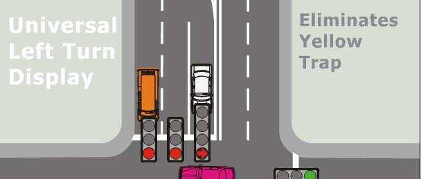
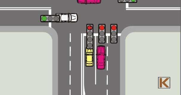
2 Innovation Demonstration Project: Presentation today will include: Implementation of Flashing Yellow Left Turn Arrows at two intersections Reasons why this was done Public Outreach and Education Impact on driver behavior Public acceptance Before and After Collision Experience
3 Flashing Yellow Arrow Background NCHRP Report 493 (2003) looked at numerous displays for P/P left turn control Report recommended use of FYLTA based on high level of driver comprehension and versatility in signal phasing Driver who did not understand indication tended to yield Numerous requests to FHWA approved for experimentation between 2004 and 2006 FHWA Issued Interim Approval for use 3/20/06 NCHRP Report 123 (2007) looked at numerous field installations of FYLTA Improved safety if intersection was P/P before install Safety not improved if Protected only before install No change in safety if Permitted only before install
4 FYLTA in Scottsdale Scottsdale received interim approval for two locations from FHWA in May 2008 We have identified several additional locations where installation would be beneficial Four intersections along Pima Road between Indian Bend and Via de Ventura will have FYLTA Implementation is easier with ASC 3 then it was with old 170 s which required numerous logic statements
5 Location No. 1 Raintree at Northsight Northsight Blvd. Raintree Dr. Raintree
6 Raintree - Northsight Characteristics Heavy southbound left turn demand heading to freeway peaks in PM Dual SB Left turn lanes, single NB left Left turns operated as permitted/protected Numerous citizen complaints of aggressive driving associated with SB lefts (minimum gap acceptance) Collisions between SB lefts and NB throughs
7 Raintree - Northsight Investigated alternatives Split phasing Protected only phasing Synchro analysis showed that these would significant increase delay and congestion Implemented FYLTA for NB/SB in October 2008
8 Public Reaction Drivers recognized that FYLTA requires them to yield Number of citizen complaints of aggressive driving went down significantly Received some complaints from drivers who did not understand indication, when questioned they did the proper thing
9 Location No th St. at McDowell McDowell Rd. 68 th St.
10 68 th St. and McDowell Characteristics Heavy NB left turn demand Dual NB left turn lanes, single SB left lane Circle K in NW quadrant generates pedestrian activity Valley gutter across north leg slows through movements Identified as high collision intersection by Tempe study of dual left turn intersections Implemented FYLTA in November 2008
11 Educational Video from WA County
 312-2526, cell: (480) 406-7153 Flashing yellow turn signals debut in Scottsdale Scottsdale s Transportation Department is installing a new type")
12 Public Outreach and Education Oct. 20, 2008 Contact: Annie DeChance, Transportation, (480) , cell: (480) Flashing yellow turn signals debut in Scottsdale Scottsdale s Transportation Department is installing a new type of traffic signal called a Flashing Yellow Left Turn Arrow to improve safety at two intersections, Raintree Drive and Northsight Boulevard and 68 th Street and McDowell Road. Only the north- and southbound traffic at these two intersections will have the new signals. The signal at Raintree and Northsight will begin operating on Tuesday, Oct. 21. The 68 th Street and McDowell Road signal will begin a few weeks later. The new devices will give drivers more options for turning left and increase safety at the intersections. Currently, both intersections have very heavy left-turn traffic northbound and southbound. The new flashing yellow left-turn signals will provide drivers a better indication that when they turn left, they must yield to the opposing through traffic and pedestrians.
13 Web Site Educational Material
14 Collision Experience Raintree/Northsight In 21 months before installation 9 collisions of SB left and NB throughs (5.1 per year) In 26 months since installation 3 collisions of SB lefts and NB throughs (1.4 per year) 68 th St./McDowell In 22 months before installation 6 collisions of NB lefts and SB throughs (3.3 per year) In 25 months since installation 4 collisions of NB lefts and BB throughs (1.92 per year)
15 Conclusions Use of Flashing Yellow Left Turn Arrows has a positive impact on collision experience when used to replace Green Ball during permitted left turn phase. Growing number of agencies are adopting FYLTA as preferred indication for permitted left Need ADOT to add the four section arrow head to the standard nomenclature Scottsdale continues to be an innovator in Arizona Traffic Engineering
16 Current ADOT Signal Head Standards
17 Current ADOT Signal Head Standards
18 Proposed New Signal Head Type P TYPE P
Flashing Yellow Left Turn Arrows Scottsdale s Experience
 Flashing Yellow Left Turn Arrows Scottsdale s Experience 2013 ITE Western District Conference July 16, 2013 Todd Taylor, P.E., PTOE City of Scottsdale Senior Traffic Engineer FYLTA Review Question NCHRP
Traffic Circulation Study for Neighborhood Southwest of Mockingbird Lane and Airline Road, Highland Park, Texas
 ARIZONA TEXAS NEW MEXICO OKLAHOMA February 13, 2015 Mr. Meran Dadgostar P.E., R.S. Town of Highland Park 4700 Drexel Dr. Highland Park, Texas 75205 Re: Traffic Circulation Study for Neighborhood Southwest
New in the MUTCD: The Flashing Yellow Arrow Presented at the 57 th Annual Traffic and Safety Conference May 17, 2006
 New in the MUTCD: The Flashing Yellow Arrow Presented at the 57 th Annual Traffic and Safety Conference May 17, 2006 David A. Noyce, Ph.D., P.E. University of Wisconsin - Madison The FYA Story Research
Final Report. Evaluation of Flashing Yellow Right Turn Arrow at Silverbell Rd and Cortaro Rd. FHWA Experimentation #4-329(E)
") Final Report Evaluation of Flashing Yellow Right Turn Arrow at Silverbell Rd and Cortaro Rd FHWA Experimentation #4-329(E) Marana, Arizona January 2009 Submitted To: Submitted By: FINAL REPORT EVALUATION
Final Report Evaluation of Flashing Yellow Right Turn Arrow at Silverbell Rd and Cortaro Rd FHWA Experimentation #4-329(E) Marana, Arizona January 2009 Submitted To: Submitted By: FINAL REPORT EVALUATION
Existing Conditions. Date: April 16 th, Dan Holderness; Coralville City Engineer Scott Larson; Coralville Assistant City Engineer
 Date: April 16 th, 2015 To: From: Re: Dan Holderness; Coralville City Engineer Scott Larson; Coralville Assistant City Engineer Darian Nagle-Gamm, Traffic Engineering Planner Highway 6 (2 nd Street) /
180 Grand Avenue, Suite x117 Dowling Associates, Inc.
 180 Grand Avenue, Suite 250 510.839.1742 x117 Oakland, CA 94612 510.839.0871 fax www.dowlinginc.com mbowman@dowlinginc.com Dowling Associates, Inc. Date: Memorandum To: CC: From: Ms. Leah Greenblat City
ORANGE COUNTY PUBLIC WORKS TRAFFIC INVESTIGATIONS
 ORANGE COUNTY PUBLIC WORKS TRAFFIC INVESTIGATIONS STAFF REPORT OF: January 6, 2019 SUPERVISORIAL DISTRICT: 5 SUBJECT: LOCATION: INVESTIGATOR: O Neill Drive at Roanoke Drive; Ladera Ranch; TB 922-E6 Clever
SCOTTSDALE ROAD HAWK 2012 Spring ITE / IMSA Conference. Presenter: Phillip Kercher, City of Scottsdale
 SCOTTSDALE ROAD HAWK 2012 Spring ITE / IMSA Conference Presenter: Phillip Kercher, City of Scottsdale Introduction HAWK = High-intensity Activated crosswalk Pedestrian Hybrid Beacon Not traffic signal
INNOVATIVE INTERSECTION DESIGN
 INNOVATIVE INTERSECTION DESIGN J. Eddie Valtier, P.E. ELP TP&D Director Introduction Why Do We Need To Start Looking For Innovative Intersection Designs? Congestion is worsening and traffic volumes and
FHWA Experimentation #4-298(E) Modified HAWK Signal and Bike Signal - Draft Report
 Modified HAWK Signal and Bike Signal - Draft Report") FHWA Experimentation #4-298(E) Modified HAWK Signal and Bike Signal - Draft Report August 2, 2010 Table of Contents Preface... 1 Problem Statement... 1 Study Objectives... 2 Data Collection Methods...
FHWA Experimentation #4-298(E) Modified HAWK Signal and Bike Signal - Draft Report August 2, 2010 Table of Contents Preface... 1 Problem Statement... 1 Study Objectives... 2 Data Collection Methods...
Pearl Street / Prospect Street / Colchester Avenue Intersection Scoping Study. April 11, 2013 Steering Committee Meeting #3
 Pearl Street / Prospect Street / Colchester Avenue Intersection Scoping Study April 11, 2013 Steering Committee Meeting #3 Meeting Agenda Welcome & Introductions Review Project Purpose & Needs Results
Abstract. Background. protected/permissive operation. Source: Google Streetview, Fairview/Orchard intersection
 ITE 2015 Western District Annual Meeting Ada County Highway District s Flashing Yellow Arrow Initiative Primary Author: Tim Curns, PE Ada County Highway District Traffic Engineer Author: Andrew Cibor,
Evaluation and Changes to Pedestrian Priority Phase Signal (Scramble Crossing) at Bay Street and Bloor Street
 at Bay Street and Bloor Street") PW2.2 STAFF REPORT ACTION REQUIRED Evaluation and Changes to Pedestrian Priority Phase Signal (Scramble Crossing) at Bay Street and Bloor Street Date: February 12, 2015 To: From: Public Works and Infrastructure
PW2.2 STAFF REPORT ACTION REQUIRED Evaluation and Changes to Pedestrian Priority Phase Signal (Scramble Crossing) at Bay Street and Bloor Street Date: February 12, 2015 To: From: Public Works and Infrastructure
Right turns at signalised intersections: Can they be standardised?
 Right turns at signalised intersections: Can they be standardised? By : S Dumakude Why standardise right turning movements at signalised intersections? Are there any benefits to standardising right turns?
IMPROVING PEDESTRIAN SAFETY AT UNCONTROLLED CROSSINGS. Guidelines for Marked Crosswalks
 IMPROVING PEDESTRIAN SAFETY AT UNCONTROLLED CROSSINGS Presented by Nazir Lalani P.E. Traffex Engineers Inc. N_lalani@hotmail.com Guidelines for Marked Crosswalks Source: FHWA, Safety Effects of Marked
Rectangular Rapid Flashing Beacons (RRFB) Pilot Project
 Pilot Project") Rectangular Rapid Flashing Beacons (RRFB) Pilot Project Nominated for: The City of Calgary Category: Road Safety Engineering Award Contact: Surendra Mishra, P. Eng., Traffic Engineer, City of Calgary ABSTRACT
Rectangular Rapid Flashing Beacons (RRFB) Pilot Project Nominated for: The City of Calgary Category: Road Safety Engineering Award Contact: Surendra Mishra, P. Eng., Traffic Engineer, City of Calgary ABSTRACT
25th Avenue Road Diet Project A One Year Evaluation. Transportation Fund for Clean Air Project #05R07
 25th Avenue Road Diet Project A One Year Evaluation Transportation Fund for Clean Air Project #05R07 Submitted by: The San Francisco Municipal Transportation Agency Dan Provence May 22, 2009 EXECUTIVE
Toronto and East York Community Council. Director, Transportation Services, Toronto and East York District
 No Turn on Red Regulations STAFF REPORT ACTION REQUIRED Date: June 1, 2010 To: From: Toronto and East York Community Council Director, Transportation Services, Toronto and East York District Wards: Trinity
Yellow and Red Intervals It s Just a Matter of Time. 58 th Annual Alabama Transportation Conference February 9, 2015
 Yellow and Red Intervals It s Just a Matter of Time 58 th Annual Alabama Transportation Conference February 9, 2015 Presentation Content Background on Timing Methodology Findings and Recommendations from
Public Involvement Outreach Requirements for Public Information Open House Meeting: C.N , HSIP-5003(12) 132 nd and West Center Road, Omaha
 132 nd and West Center Road, Omaha") To: NDOR Environmental From: Randy McCart, HDR Date: 4 April 2017 RE: Public Involvement Summary Report, HSIP-5003(12) 132 nd and West Center Road, Omaha; C.N. 22629 Public Involvement Outreach Requirements
To: NDOR Environmental From: Randy McCart, HDR Date: 4 April 2017 RE: Public Involvement Summary Report, HSIP-5003(12) 132 nd and West Center Road, Omaha; C.N. 22629 Public Involvement Outreach Requirements
Intersection of Massachusetts Avenue and Maple Street in Lexington Signalized Intersection and Roundabout Comparison
 Intersection of Massachusetts Avenue and Maple Street in Lexington Signalized Intersection and Roundabout Comparison Michael Wallwork, Roundabout Expert, Orange Park, Florida Tom Bertulis (MS, PE, PTOE),
City of Bellevue s Adaptive Left Turn Phasing. Presented by : Mark Poch, PE, PTOE City of Bellevue, WA
 City of Bellevue s Adaptive Left Turn Phasing Presented by : Mark Poch, PE, PTOE City of Bellevue, WA May 1, 2015 130,000 pop. 197 signals The Challenge Protected Only Turns The Challenge Protected Only
133 rd Street and 132 nd /Hemlock Street 132 nd Street and Foster Street MINI ROUNDABOUTS. Overland Park, Kansas
 133 rd Street and 132 nd /Hemlock Street 132 nd Street and Foster Street MINI ROUNDABOUTS Overland Park, Kansas September 1, 2017 TABLE OF CONTENTS 1. INTRODUCTION... 1 2. LITERATURE REVIEW... 1 3. CONCEPT
Reference: Laguna Canyon Road Traffic Conditions Data Collection Summary
 Stantec Consulting Services Inc. 38 Technology Drive Suite 100, Irvine CA 92618-5312 September 8, 2017 File: 2073014320 Attention: Mark Trestik, Assistant City Engineer City of Beach Department of Public
TRAFFIC AND SAFETY CONFERENCE October 18, 2017 FLASHING YELLOW ARROWS
 TRAFFIC AND SAFETY CONFERENCE October 18, 2017 FLASHING YELLOW ARROWS FLASHING YELLOW ARROWS LEFT TURN YIELD ON FLASHIN G ARROW How did it get started Early Research Our projects Outreach Construction
I-264 CORRIDOR EVALUATION STUDY. September 7, 2016 Eric Stringfield VDOT Planning Director Chris Lawrence AECOM Senior Transportation Engineer
 I-264 CORRIDOR EVALUATION STUDY September 7, 2016 Eric Stringfield VDOT Planning Director Chris Lawrence AECOM Senior Transportation Engineer Study Overview Interchange Locations Study Context Follow-up
Optimizing The Operations of Closely Spaced Traffic Signals. Gordon E. Meth, P.E., PTOE ITE District 1 Annual Meeting May 21, 2004
 Optimizing The Operations of Closely Spaced Traffic Signals Gordon E. Meth, P.E., PTOE ITE District 1 Annual Meeting May 21, 2004 Closely Spaced Signals - The Challenges According to many sources, minimum
Draft North Industrial Area-Wide Traffic Plan
 Summary of North Industrial and Hudson Bay Industrial Recommended Improvements Table 1. Summary of s Item Location 1 2 3 4 5 6 7 8 9 10 11 12 Millar Ave north of 51st St Super 8 Motel back lane 400 Block
The Traffic Monitoring Guide: Counting Bicyclists and Pedestrians. APBP 2017 June 28: 11:15am-12:45pm
 The Traffic Monitoring Guide: Counting Bicyclists and Pedestrians APBP 2017 June 28: 11:15am-12:45pm 2 Presentation Organization Why count bicyclists and pedestrians? Why report count data? What resources
Memorandum. Fund Allocation Fund Programming Policy/Legislation Plan/Study Capital Project Oversight/Delivery Budget/Finance Contract/Agreement Other:
 Memorandum Date: November 20, 2017 To: Transportation Authority Board From: Eric Cordoba Deputy Director Capital Projects Subject: 12/5/17 Board Meeting: San Francisco Freeway Corridor Management Study
SAN FRANCISCO MUNICIPAL TRANSPORTATION AGENCY
 THIS PRINT COVERS CALENDAR ITEM NO. : 11 DIVISION: Sustainable Streets BRIEF DESCRIPTION: SAN FRANCISCO MUNICIPAL TRANSPORTATION AGENCY Approving traffic modifications on Twin Peaks Boulevard between Christmas
Welcome! San Jose Avenue Open House August 25, 2015
 Welcome! San Jose Avenue Open House August 25, 2015 Vision Zero The City and County of San Francisco adopted Vision Zero San Francisco Vision Zero High Injury Network as a policy in 2014, committing an
Improving Pedestrian Safety at Unsignalized Crossings. Shawn Turner, P.E. Texas A&M Transportation Institute
 Improving Pedestrian Safety at Unsignalized Crossings Shawn Turner, P.E. Texas A&M Transportation Institute Overview of Presentation What are the issues/problems? Framework for crossing treatments Marked
Offset Single Point Interchange I-25 at Rio Bravo Boulevard Albuquerque, New Mexico
 Offset Single Point Interchange I-25 at Rio Bravo Boulevard Albuquerque, New Mexico INSTITUTE OF TRANSPORTATION ENGINEERS 2016 WESTERN DISTRICT MEETING JULY 11, 2016 7/11/2016 1 Project Vicinity Map 7/11/2016
2012 TOWN OF CASTLE ROCK MOTOR VEHICLE ACCIDENT FACTS PREPARED BY THE PUBLIC WORKS DEPARTMENT
 ATTACHMENT A 2012 TOWN OF CASTLE ROCK MOTOR VEHICLE ACCIDENT FACTS PREPARED BY THE PUBLIC WORKS DEPARTMENT ACKNOWLEDGEMENTS This report was assembled from data provided by the Castle Rock Police Department
IMPACTS OF TRAFFIC RESTRICTIONS AND INFRASTRUCTURE IMPROVEMENTS ON DOWNTOWN PEAK HOUR CONGESTION: A SYNCHRO ANALYSIS FOR BELLEVUE, WASHINGTON
 Final Technical Report TNW2009-06 IMPACTS OF TRAFFIC RESTRICTIONS AND INFRASTRUCTURE IMPROVEMENTS ON DOWNTOWN PEAK HOUR CONGESTION: A SYNCHRO ANALYSIS FOR BELLEVUE, WASHINGTON Chris Masek, P.E. Nancy Nihan,
Simulating Street-Running LRT Terminus Station Options in Dense Urban Environments Shaumik Pal, Rajat Parashar and Michael Meyer
 Simulating Street-Running LRT Terminus Station Options in Dense Urban Environments Shaumik Pal, Rajat Parashar and Michael Meyer Abstract The Exposition Corridor transit project is a light rail project
What's in the 2012 California MUTCD for Pedestrians, Bicyclists, and School Areas?
 What's in the 2012 California MUTCD for Pedestrians, Bicyclists, and School Areas? CA MUTCD 2012 edits by John Ciccarelli Member, California Traffic Control Devices Committee Member, NCUTCD Bicycle Technical
Flashing Yellow Arrows (A different left turn option) ASCE Meeting June 9, 2015 Kerry C. NeSmith, PE Deputy State Maintenance Engineer
 ASCE Meeting June 9, 2015 Kerry C. NeSmith, PE Deputy State Maintenance Engineer") Flashing Yellow Arrows (A different left turn option) ASCE Meeting June 9, 2015 Kerry C. NeSmith, PE Deputy State Maintenance Engineer What IS the flashing yellow arrow??? Traditional left turn signal
Flashing Yellow Arrows (A different left turn option) ASCE Meeting June 9, 2015 Kerry C. NeSmith, PE Deputy State Maintenance Engineer What IS the flashing yellow arrow??? Traditional left turn signal
USER GUIDE FOR R1-6 GATEWAY TREATMENT
 USER GUIDE FOR R1-6 GATEWAY TREATMENT FOR PEDESTRIAN CROSSINGS Prepared by: Western Michigan University T.Y. Lin International December 2016 Acknowledgements Michigan Department of Transportation MDOT
Harrah s Station Square Casino
 Transportation Analysis Harrah s Station Square Casino Pittsburgh, Pennsylvania Submitted To: City of Pittsburgh and Pennsylvania Gaming Control Board Prepared By: DKS Associates GAI Consultants December
5858 N COLLEGE, LLC N College Avenue Traffic Impact Study
 5858 N COLLEGE, LLC nue Traffic Impact Study August 22, 2016 Contents Traffic Impact Study Page Preparer Qualifications... 1 Introduction... 2 Existing Roadway Conditions... 5 Existing Traffic Conditions...
Congestion Mitigation at IH 27 and U.S. Hwy 70 in Plainview, TX
 2010 Congestion Mitigation at IH 27 and U.S. Hwy 70 in Plainview, TX Hongchao Liu, Hao Xu, and Rhett Dollins Multidisciplinary Research in Transportation Texas Tech University Mulidisciplinary Research
USER GUIDE FOR R1-6 GATEWAY TREATMENT
 USER GUIDE FOR R1-6 GATEWAY TREATMENT FOR PEDESTRIAN CROSSINGS Prepared by: Western Michigan University T.Y. Lin International December 2016 Updated May 2018 Acknowledgements Michigan Department of Transportation
3.16 TRANSPORTATION, CIRCULATION, AND PARKING Regulatory Setting Environmental Setting ROADWAY SYSTEM
 3.16 TRANSPORTATION, CIRCULATION, AND PARKING This section assesses the potential for implementation of the Orchard Park Redevelopment component of the 2018 LRDP to result in impacts related to transportation,
Santa Clara I-280 CORRIDOR STUDY
 Santa Clara I-280 CORRIDOR STUDY OCTOBER 2017 PREPARED BY: 1.1 Background The I-280 Corridor Study within Santa Clara County is a high-level highway planning study led by the Santa Clara VTA, in partnership
BENNING ROAD & BRIDGES TRANSPORTATION IMPROVEMENTS CRASH DATA AND SAFETY ANALYSIS TECHNICAL MEMORANDUM DRAFT MAY 2016
 BENNING ROAD & BRIDGES TRANSPORTATION IMPROVEMENTS CRASH DATA AND SAFETY ANALYSIS TECHNICAL MEMORANDUM DRAFT MAY 2016 This page left intentionally blank. Table of Contents 1.0 Introduction... 1 1.1 Crash
MUTCD (HAWK) 2016 & Adapting the Pedestrian Hybrid Beacon (HAWK) to Facilitate Bicycle Use. ITE-IMSA March, 2014
 2016 & Adapting the Pedestrian Hybrid Beacon (HAWK) to Facilitate Bicycle Use. ITE-IMSA March, 2014") MUTCD (HAWK) 2016 & Adapting the Pedestrian Hybrid Beacon (HAWK) to Facilitate Bicycle Use Presented By Richard Nassi, P.E., Ph.D. PAG Engineering Consultant Services, CA 0344 Traffic Engineering Gabriel
MUTCD (HAWK) 2016 & Adapting the Pedestrian Hybrid Beacon (HAWK) to Facilitate Bicycle Use Presented By Richard Nassi, P.E., Ph.D. PAG Engineering Consultant Services, CA 0344 Traffic Engineering Gabriel
Scottsdale Road/Rural Road Alternatives Analysis (AA) Study. Arizona ITE/IMSA Spring Conference March 7, 2012
 Study. Arizona ITE/IMSA Spring Conference March 7, 2012") Scottsdale Road/Rural Road Alternatives Analysis (AA) Study Arizona ITE/IMSA Spring Conference March 7, 2012 Study Location and Duration Primary Study Corridor (major focus of effort) Rural Road and Scottsdale
Scottsdale Road/Rural Road Alternatives Analysis (AA) Study Arizona ITE/IMSA Spring Conference March 7, 2012 Study Location and Duration Primary Study Corridor (major focus of effort) Rural Road and Scottsdale
Reference number /VP. Lafayette Downtown Congestion Study - Additional Traffic Analysis
 To James Hinkamp and Tony Coe, City of Lafayette Date January 19, 2017 Copies Reference number 243381/VP From Michael Iswalt and Vanessa Peers File reference 4-05 Subject Lafayette Downtown Congestion
Project Report. South Kirkwood Road Traffic Study. Meadows Place, TX October 9, 2015
 Meadows Place, TX October 9, 2015 Contents 1 Introduction... 1 2 Data Collection... 1 3 Existing Roadway Network... 2 4 Traffic Volume Development... 2 5 Warrant Analysis... 3 6 Traffic Control Alternative
Bay to Bay Boulevard Complete Streets Project
 Bay to Bay Boulevard Complete Streets Project Dale Mabry Highway to Bayshore Boulevard February 08, 2018 Photo Source: Tampa Bay Times Alessandra Da Pra Meeting Format Introduction Resurfacing Information
Agenda. Introduction to Roundabouts. Introduction to Roundabouts. Introduction to Roundabouts 6/6/2018
 PROPOSED PROJECT 161-003 SAFETY AND OPERATIONAL IMPROVEMENTS TO THE INTERSECTION OF ROUTE 106 (NEW CANAAN ROAD) AND BELDEN HILL ROAD Connecticut Department of Transportation Representatives Division of
ARTINSVILLE ENRY OUNTY REA RANSPORTATION TUDY
 ARTINSVILLE ENRY OUNTY REA RANSPORTATION TUDY DEVELOPED BY THE TRANSPORTATION AND MOBILITY PLANNING DIVISION OF THE VIRGINIA DEPARTMENT OF TRANSPORTATION IN COOPERATION WITH THE U.S. DEPARTMENT OF TRANSPORTATION,
STEP. Rectangular Rapid Flashing Beacons. Safe Transportation for Every Pedestrian
 STEP Safe Transportation for Every Pedestrian Rectangular Rapid Flashing Beacons Duane Thomas, Federal Highway Administration Megan McCarty Graham, Toole Design October 30, 2018 Housekeeping Problems with
INNOVATIVE INTERSECTION SOLUTIONS. Jay Bockisch, PE, PTOE Senior Associate
 INNOVATIVE INTERSECTION SOLUTIONS Jay Bockisch, PE, PTOE Senior Associate INNOVATIVE INTERSECTION SOLUTIONS Innovative intersection overview Case studies Continuous flow intersection Modern roundabouts
Giles Run Connector Road
 Giles Run Connector Road Laurel Hill Adaptive Reuse Area to Laurel Crest Drive South County Federation Meeting June 14, 2016 History Connector road included in the Laurel Hill Comprehensive Plan amendment
Roundabout Evaluations in Virginia: US 15/US 50 Gilberts Corner, VA SR 106/SR 634 Prince George County, VA
 Roundabout Evaluations in Virginia: US 15/US 50 Gilberts Corner, VA SR 106/SR 634 Prince George County, VA VDOT & FHWA Roundabout Workshop September 17, 2013 Chris Tiesler, PE Presentation Outline US 15/US
Northbound San Jose Avenue & I-280 Off-Ramp Road Diet Pilot Project
 Project Overview Fed by a two-lane Interstate-280 (I-280) off-ramp, high vehicular volumes and speeds are longstanding issues along San Jose Avenue. Residents in the surrounding neighborhoods have expressed
REVIEW OF LOCAL TRAFFIC FLOW / LONG RANGE PLANNING SOLUTIONS STUDY
 ITEM Town of Atherton TRANSPORTATION COMMITTEE STAFF REPORT TO: FROM: MEMBERS OF THE COMMITTEE ROBERT OVADIA, PUBLIC WORKS DIRECTOR DATE: FEBRUARY 12, 2019 SUBJECT: REVIEW OF LOCAL TRAFFIC FLOW / LONG
Driver Behavior in the Presence of Pedestrians at Signalized Intersections Operating the Flashing Yellow Arrow
 Portland State University PDXScholar Civil and Environmental Engineering Faculty Publications and Presentations Civil and Environmental Engineering 2-2013 Driver Behavior in the Presence of Pedestrians
8 PROPOSED ROUNDABOUT DUFFERIN STREET AND KING VAUGHAN ROAD INTERSECTION CITY OF VAUGHAN
 8 PROPOSED ROUNDABOUT DUFFERIN STREET AND KING VAUGHAN ROAD INTERSECTION CITY OF VAUGHAN The Transportation Services Committee recommends the adoption of the recommendation contained in the following report
Diverging Diamond Interchange and Double Crossover Intersection Vehicle and Pedestrian Performance
 Diverging Diamond Interchange and Double Crossover Intersection Vehicle and Pedestrian Performance Praveen K. Edara, Department of Civil and Environmental Engineering, Virginia Polytechnic Institute and
Evaluation of M-99 (Broad Street) Road Diet and Intersection Operational Investigation
 Road Diet and Intersection Operational Investigation") Evaluation of M-99 (Broad Street) Road Diet and Intersection Operational Investigation City of Hillsdale, Hillsdale County, Michigan June 16, 2016 Final Report Prepared for City of Hillsdale 97 North Broad
Evaluation of M-99 (Broad Street) Road Diet and Intersection Operational Investigation City of Hillsdale, Hillsdale County, Michigan June 16, 2016 Final Report Prepared for City of Hillsdale 97 North Broad
Financial Project ID No(s).: and ETDM No(s).: and 14181
.: and ETDM No(s).: and 14181") Palm Beach Metropolitan Planning Organization (MPO) Presentation I-95 at Boynton Beach Boulevard Interchange and I-95 at Gateway Boulevard Interchange Project Development and Environment Study Palm Beach
Palm Beach Metropolitan Planning Organization (MPO) Presentation I-95 at Boynton Beach Boulevard Interchange and I-95 at Gateway Boulevard Interchange Project Development and Environment Study Palm Beach
EVALUATION OF HAWK SIGNAL AT GEORGIA AVENUE AND HEMLOCK STREET, NW IN THE DISTRICT OF COLUMBIA FINAL REPORT. August 30, 2010
 EVALUATION OF HAWK SIGNAL AT GEORGIA AVENUE AND HEMLOCK STREET, NW IN THE DISTRICT OF COLUMBIA FINAL REPORT August 30, 2010 Submitted to: Mr. George Branyan Pedestrian Program Manager Policy, Planning
BLOSSOM AT PICKENS SIGNALIZED INTERSECTION IMPROVEMENT STUDY
 BLOSSOM AT PICKENS SIGNALIZED INTERSECTION IMPROVEMENT STUDY Class Project Report for ECIV 542 Traffic Engineering Submitted by Omor Sharif Muchun Song Narges Kaveshgar Quyen Pham Chih-Yao Lin Submission
Traffic Signal Optimization Project (Hosman Road) (Future Coordinated Corridor)
 (Future Coordinated Corridor)") Onondaga County Department of Transportation Traffic Signal Optimization Project (Hosman Road) (Future Coordinated Corridor) Prepared for: Syracuse Metropolitan Transportation Council 126 North Salina
Onondaga County Department of Transportation Traffic Signal Optimization Project (Hosman Road) (Future Coordinated Corridor) Prepared for: Syracuse Metropolitan Transportation Council 126 North Salina
Arlington Public Schools New Elementary School at Thomas Jefferson Site Off-Site Transportation. Thomas Jefferson BLPC / PFRC Meeting July 27, 2016
 Arlington Public Schools New Elementary School at Thomas Jefferson Site Off-Site Transportation Thomas Jefferson BLPC / PFRC Meeting July 27, 2016 1.Review of Analysis 2.Key Transportation Issues 3.Recommendations
Traffic Signal Optimization Project (Electronics Parkway/Henry Clay Boulevard) (Future Coordinated Corridor)
 (Future Coordinated Corridor)") Onondaga County Department of Transportation Traffic Signal Optimization Project (Electronics Parkway/Henry Clay Boulevard) (Future Coordinated Corridor) Prepared for: Syracuse Metropolitan Transportation
Onondaga County Department of Transportation Traffic Signal Optimization Project (Electronics Parkway/Henry Clay Boulevard) (Future Coordinated Corridor) Prepared for: Syracuse Metropolitan Transportation
Roundabout Design: Safety and Capacity Background Paper July 25, 2004
 Roundabout Design: Safety and Capacity Background Paper July 25, 2004 Introduction According to the May 13, 2000 Insurance Institute for Highway Safety (IIHS) Status Report, roundabouts have been shown
DUNBOW ROAD FUNCTIONAL PLANNING
 DUNBOW ROAD FUNCTIONAL PLANNING Final Report August 3, 216 #31, 316 5th Avenue NE Calgary, AB T2A 6K4 Phone: 43.273.91 Fax: 43.273.344 wattconsultinggroup.com Dunbow Road Functional Planning Final Report
Washington St. Corridor Study
 FIGURE 7.17 Bridge Alternatives - Cross Sections 86 Discarded Alternative: Short-Term Bridge Repair Short-term repairs and west bridge span replacement were considered during analysis. Short-term repairs
NO BUILD TRAFFIC OPERATIONS
 3. 23 NO BUILD TRAFFIC OPERATIONS This section addresses the operations of the transportation system and details how it would be expected to function under year 23 No Build conditions with the projected
CITY OF OTTAWA ROADWAY MODIFICATION APPROVAL UNDER DELEGATED AUTHORITY
 RMA-2015-ATM-038 CITY OF OTTAWA ROADWAY MODIFICATION APPROVAL UNDER DELEGATED AUTHORITY DATE: April 22, 2015 SUBJECT Approval of Roadway Modifications Recommended through an Area Traffic Management Study
ALLEY 24 TRAFFIC STUDY
 ALLEY 24 TRAFFIC STUDY in City of Frostburg, Maryland January 2013 3566 Teays Valley Road Hurricane, WV Office: (304) 397-5508 www.denniscorporation.com Alley 24 Traffic Study January 2013 Frostburg, Maryland
Transportation Advisory Board
 C I T Y O F WEATHERFORD Transportation Advisory Board AGENDA REPORT Meeting Date: October 15,2015 Staff Contact: Manny Palacios Jr. Phone: E-mail: 817-598-4296 mpalacios@weatherfordtx.gov SUBJECT: Discuss
Application of Diamond Interchange Control Strategies at Closely Spaced Intersections
 Application of Diamond Interchange Control Strategies at Closely Spaced Intersections Zong Tian, Thomas Urbanik II, and Reed Gibby Signalized diamond interchanges are one of the most common interchange
San Tomas Expressway
 Implementation Plan San Tomas Expressway Roads and Airports Department August 19, 2003 Implementation Plan San Tomas Expressway County of Santa Clara Roads and Airports Department 101 Skyport Drive San
3.0 PROJECT DESCRIPTION
 The following section of the Draft EIR contains a description of the proposed Elk Grove Boulevard/SR 99 Interchange Modification project, consistent with the requirements of CEQA Guidelines Section 15124.
MEMORANDUM. Charlotte Fleetwood, Transportation Planner
 MEMORANDUM Date: Updated August 22, 2017 To: Organization: Charlotte Fleetwood, Transportation Planner Boston Transportation Department From: Jason DeGray, P.E., PTOE, Regional Director of Engineering
EFFECT OF TRAFFIC ROUNDABOUTS ON SAFETY IN ARIZONA
 Project ID: NTC2015-SU-R-3 EFFECT OF TRAFFIC ROUNDABOUTS ON SAFETY IN ARIZONA Final Report by Michael Mamlouk, Ph.D., P.E. Professor, mamlouk@asu.edu, 480-965-2892 Beshoy Souliman Research Assistant Arizona
I-95 NORTHBOUND AT US 1 (EXIT 126) ALTERNATIVES DESIGN ANALYSIS
 ALTERNATIVES DESIGN ANALYSIS") FAMPO Policy Committee Briefing June 18, 2018 I-95 NORTHBOUND AT US 1 (EXIT 126) ALTERNATIVES DESIGN ANALYSIS WHAT IS THE STARS PROGRAM? Program to develop solutions to reduce crashes and congestion bottlenecks
FAMPO Policy Committee Briefing June 18, 2018 I-95 NORTHBOUND AT US 1 (EXIT 126) ALTERNATIVES DESIGN ANALYSIS WHAT IS THE STARS PROGRAM? Program to develop solutions to reduce crashes and congestion bottlenecks
Introduction to Traffic Signal Timing
 Introduction to Traffic Signal Timing Course No: C-7 Credit: PDH Jeffrey W. Buckholz, Ph.D., P.E., PTOE Continuing Education and Development, Inc. 9 Greyridge Farm Court Stony Point, NY 98 P: (877) -58
TRAFFIC CONTROL DEVICES ON EDGEWATER BOULEVARD AT PORT ROYAL AVENUE (NORTH)
") Attachment 2 DATE: August 6, 2012 TO: VIA: FROM: SUBJECT: Mayor and Members of the City Council James C. Hardy, City Manager Ramon Towne, Director of Public Works Leah Edwards, Assistant Engineer TRAFFIC
Attachment 2 DATE: August 6, 2012 TO: VIA: FROM: SUBJECT: Mayor and Members of the City Council James C. Hardy, City Manager Ramon Towne, Director of Public Works Leah Edwards, Assistant Engineer TRAFFIC
INTERSECTION SAFETY AUDIT: STH 16/67 AND CTH Z
 WISCONSIN DEPARTMENT OF TRANSPORTATION INTERSECTION SAFETY AUDIT: STH 16/67 AND CTH Z OCONOMOWOC, WI WISCONSIN DEPARTMENT OF TRANSPORTATION INTERSECTION SAFETY AUDIT: STH 16/67 AND CTH Z OCONOMOWOC, WI
LOOP 360 IMPROVEMENT STUDY
 LOOP 360 IMPROVEMENT STUDY Overview and Preliminary Analysis August 2015 1 STUDY PROCESS 2 Study Background Loop 360 serves a wide range of users, including residents, businesses, bicyclists, and commuters
MoPac South: Impact on Cesar Chavez Street and the Downtown Network
 MoPac South: Impact on Cesar Chavez Street and the Downtown Network Prepared by: The University of Texas at Austin Center for Transportation Research Prepared for: Central Texas Regional Mobility Authority
RM 620/RM 2222 CONNECTOR (BYPASS) STATUS REPORT RM 620/2222 STATUS
 STATUS REPORT RM 620/2222 STATUS") RM 620/RM 2222 CONNECTOR (BYPASS) STATUS REPORT January 25, 2017 RM 620/2222 BYPASS - INTRODUCTION Because of the enormous traffic demand at the RM 620/2222 intersection, TxDOT searched for a way to relieve
RM 620/RM 2222 CONNECTOR (BYPASS) STATUS REPORT January 25, 2017 RM 620/2222 BYPASS - INTRODUCTION Because of the enormous traffic demand at the RM 620/2222 intersection, TxDOT searched for a way to relieve
Effects of Traffic Signal Retiming on Safety. Peter J. Yauch, P.E., PTOE Program Manager, TSM&O Albeck Gerken, Inc.
 Effects of Traffic Signal Retiming on Safety Peter J. Yauch, P.E., PTOE Program Manager, TSM&O Albeck Gerken, Inc. Introduction It has long been recognized that traffic signal timing can have an impact
PROJECT NO. 093 MA 199 H C. FEDERAL NO. xxxx WIKIEUP-WICKENBURG-PHOENIX HIGHWAY TEGNER STREET, ALTERNATIVE 10 PROJECT IMPROVEMENT
 PROJECT NO. 093 MA 199 H 5807 01C FEDERAL NO. xxxx WIKIEUP-WICKENBURG-PHOENI HIGHWAY TEGNER STREET, ALTERNATIVE 10 PROJECT IMPROVEMENT (INTERSECTION IMPROVEMENT) US 93/US 60 FINAL PROJECT ASSESSMENT April
PRELIMINARY DRAFT WADDLE ROAD / I-99 INTERCHANGE PROJECT ALTERNATIVE ANALYSIS FINAL TRAFFIC SUMMARY REPORT
 PRELIMINARY DRAFT WADDLE ROAD / I-99 INTERCHANGE PROJECT ALTERNATIVE ANALYSIS FINAL TRAFFIC SUMMARY REPORT Prepared by: In Association with: November 2013 EXECUTIVE SUMMARY Patton Township, in partnership
Intersection LOS Intersection level of service (LOS) is defined by the Highway Capacity Manual (HCM) by the following criteria:
 is defined by the Highway Capacity Manual (HCM) by the following criteria:") Page 2 of 9 Intersection LOS Intersection level of service (LOS) is defined by the Highway Capacity Manual (HCM) by the following criteria: Table 1 LOS Definitions Level of Signalized Un-Signalized Definition
Page 2 of 9 Intersection LOS Intersection level of service (LOS) is defined by the Highway Capacity Manual (HCM) by the following criteria: Table 1 LOS Definitions Level of Signalized Un-Signalized Definition
Brian McHugh, Buckhead Community Improvement District. SUBJECT: Wieuca Road at Phipps Boulevard Intersection Improvements Project
 MEMO TO: FROM: Brian McHugh, Buckhead Community Improvement District Jagan Kaja, AICP, WSP Parsons Brinckerhoff SUBJECT: Wieuca Road at Phipps Boulevard Intersection Improvements Project DATE: October
FINAL DESIGN TRAFFIC TECHNICAL MEMORANDUM
 FINAL DESIGN TRAFFIC TECHNICAL MEMORANDUM July 2014 FINAL (SR 43) Project Development and Environment Study From State Road 60 (Adamo Drive) to I-4 (SR 400) Hillsborough County, Florida Work Program Item
Station 1: Street & Sidewalk Upgrades
 Station 1: Street & Sidewalk Upgrades Existing no left turn; Potential left turn arrow, see Circulation Study boards for more information Thru-lane guidance Improved lead-in green bike lane 17TH ST CASTRO
PEDESTRIAN ACCOMMODATIONS DPS 201 AT INTERCHANGES
 PEDESTRIAN ACCOMMODATIONS DPS 201 AT INTERCHANGES UNDERSTANDING THE ISSUES Intersections of freeway ramp terminals at crossroads are the most critical components of an interchange Challenge: balance mobility
WELCOME PTH 59N - PTH 101 INTERCHANGE FUNCTIONAL DESIGN STUDY PUBLIC INFORMATION SESSION MONDAY, JUNE 13, :00 P.M. - 8:00 P.M.
 WELCOME - PTH 1 INTERCHANGE FUNCTIONAL DESIGN STUDY PUBLIC INFORMATION SESSION MONDAY, JUNE 13, 11 4:00 P.M. - 8:00 P.M. PROJECT STUDY AREA 1 Wenzel Street PR 2 Pritchard Farm Farm Road Road McGregor Farm
Public Works and Infrastructure Committee. General Manager, Transportation Services
 STAFF REPORT ACTION REQUIRED Extending the Bay Street Bicycle Lanes Date: May 16, 2013 To: From: Public Works and Infrastructure Committee General Manager, Transportation Services Wards: Toronto Centre
Transportation Planning Division
 Transportation Planning Division Presentation Outline Study Tasks Recap of Previous Meetings Data Collected Focus Areas within Study Limits Design Principles Tool Box Recommended Concepts Schedule Moving