MOBILITY ACCESSIBILITY
|
|
|
- Patience Hampton
- 5 years ago
- Views:
Transcription
1 MOBILITY OR ACCESSIBILITY
2 Alternative Mobility Solutions and Pedestrianization of Existing Urban Neighbourhoods (AAPKI SADAK) Project Team Ashok B. Lall Architects Aastha Chauhan Innovative Transport Solutions Oasis Design Incorporated SGArchitects SUPPORTED BY: SHAKTI SUSTAINABLE ENERGY FOUNDATION a community engagement led process with detailed surveys and technical design support to arrive at practical solutions Draft Proposal


 Even the largest centre driven urban")
3 TRANSIT CONNECTIVITY IN DELHI CWG STREET IMPROVEMENTS CNG BASED PUBLIC TRANSPORT DELHI METRO BUS RAPID TRANSIT yet Where is the enjoyment of the city? Where is the improvement to social life? Source: Source: TOO MANY RESOURCES? TOO MUCH MONEY NEEDED? Indian Infrastructure Report (Baindur & Kamath, 2009); During the year ( ), the High Powered Expert Committee (HPEC) for urban infrastructure services estimated the total investment requirements for urban infrastructure, renewal, and redevelopment (including slums) at Rs 39,00,000 crore (at prices) during The largest share of this investment is required for urban roads (about 44 per cent) Even the largest centre driven urban infrastructure programme, JNNURM, has not been able to contribute much towards meeting the investment requirements. Source: automotivehorizon.sulekha.com OR IS THE ANSWER MUCH

4 THE FIRST / LAST MILE PROBLEM.And The Neighbouhood Vehicular dependence Unliveable neighbourhoods Lack of pedestrian / NMT infrastructure Universal access Clutter & obstacles Parking crisis Micro level issues unaddressed Source: Das, et. al, Decision, Vol. 37, No.2, August, 2010 Source: fhwa.dot.gov Source: pedestrianliberation.org
 The fourth aspect")

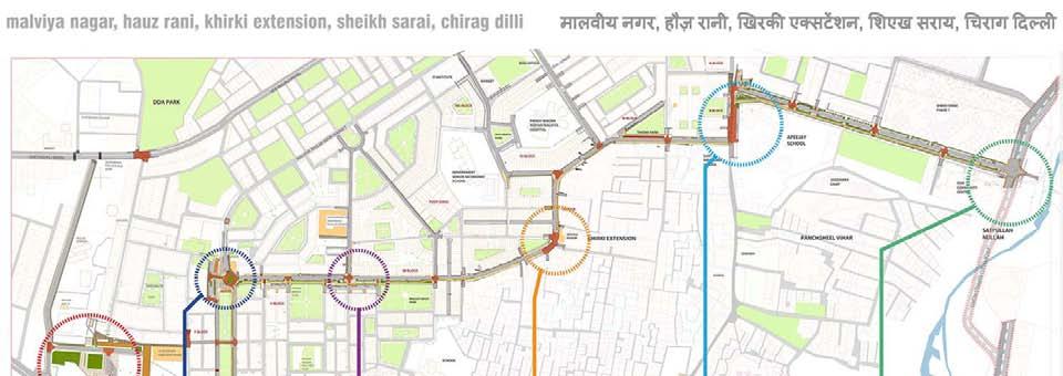
5 SITE SELECTION F-10 Sub Zone The site selected for the project is located within the urban precinct bounded on three sides by major vehicular roads (Outer Ring Road, Lal Bahadur Shastri Marg and Press Enclave Road) The fourth aspect is bounded by a congested internal road, Geetanjali Marg, running parallel to the Malviya Nagar Market. It is connected to the Transit system via the Malviya Nagar Metro Station in the south west corner and the BRTS corridor on the east.


6 SITE A TYPICAL URBAN PRECINCT IN DELHI The Landuse Plan of Zone F-10 as per ZDP. According to official record, the area is mainly residential and represented as a single fabric with little complexity. However, even on an initial visual and physical analysis it is revealed that; Footpaths are too narrow, high, and or broken Not accessible to differentlyabled persons No direct pedestrian or cycle access to important public transit nodes due to high speed traffic barriers Un-co-ordinated design of public utilities and poor maintenance leading to obstruction of pedestrian traffic (location of electric pillars, incorrectly placed fencing, flooding in subways etc.) Absence of certain NMT modes due to over congestion by personal automobiles The REAL condition on ground considering the neighbourhoods and diversity within the selected study area

7 SURVEY & ANALYSIS TOPOGRAPHIC SURVEY TRAFFIC SURVEYS PHOTOGRAPHIC SURVEY USER SURVEYS PARKING COUNTS Analysis Effective Right Of Way Available Open Land & Potential Traffic Flow Analysis Public Transport Routes & Connectivity User Survey Analysis Activity Mapping Of Major Areas
 N Block Residence of Mr.")
8 COMMUNITY WORKSHOPS - Locations 9 Community Park in all: Shivalik A Block Park F Block Linear Park Hitesh Mehta Park Bhagat Singh Park Ravi Mehta Park Tikona Park RPS Apts. Park Indoor Brainstorming: Gurudwara Babadeep Singh (Metro Links and F Block) N Block Residence of Mr. R P Kakkar (Ward Committee and MN RWA issues addressed)


9 Bus depot COMMUNITY WORKSHOPS - Exercises Trip Capture / Dots Exercise (TC) The chart highlights several of the local landmarks and lays them out left to right on the basis of their distance from the neighbourhood / typical resident. The chart was aimed at capturing data on which landmarks / locations are most frequented by residents and the degree of difficulty faced by them in accessing them on foot / by cycling in an engaging, fun format. It was particularly aimed at people who find maps confusing, so as to include everyone in the conversation. LEGEND Easily Accessible Moderately Accessible With Difficulty Modal Choice Capture (MCC) This chart was similar to the one used in T1 workshop, although focused on residents and their preferred mode of travel. It also captured who in the family preferred which means.

10 The junction to be refurbished with traffic calming and better crossing facilities to reach the most frequently visited DDA Park. Refurbish the street section, provide segregated footpath with proper lights, as most used road by Shivalik residents of all age groups. COMMUNITY WORKSHOPS Inferences Malviya nagar Market Street Refurbish Malviya Nagar street section, provide segregated footpath with proper lights, with proper on street parking to prevent encroachments. The Gol Chakkar as bus terminal or parking needs to be given a thought. Identify & Create shorter routes to reach to the Metro Gate No.3 The route to reach Metro Gate No. 02 to be redesigned along with regulating the opening closing timings of society gate

11 Linear Park - Shivalik COMMUNITY WORKSHOPS - Demands Traffic on this narrow lane is actually mostly passing through, for Lado Sarai, Mehrauli, etc. Too much for this width People have vacated the ground floors due to traffic & congestion if front of houses Dedicated footpath is a is must. a must. A Block - Shivalik Designated parking space elsewhere is demanded is demanded in order in order to free to up free walking up space walking space Children demand safe cycling areas / routes Tuition routes are dimly lit Existing connections to the Metro are too long Third Metro Exit for Shivalik blocked by colony Other gates also restrict movement Improvement of Metro Exit Road between Geetanjali and Shivalik is critical Tikona Park Malviya Nagar Designated parking space elsewhere is demanded in order to free up walking space. Road junctions need to be designed such that speeding cars are slowed down and it is easy to cross the road without going up and down. Encroachment of shops and shopkeepers parking in front of shops needs to be dealt with. Rickshaws or alternative feeder service to reach public transport in an affordable way, demanded. Bus services have to be reinstated and strengthened. Particularly for senior citizens. Improvement of Main Market area for parking, walking and shopping is critical Hospitals in the area need better emergency access and critical idling / parking space School hours need to be managed much better. Traffic coordination demanded F-Block - Malviya Nagar Access to Metro in front of Hauz Rani is not good. Improvement of existing link should be first priority. Development of further network of pedestrian and NMT routes to Metro is agreeable. Eventually giving rise to the.. Walls gates might be reconsidered Walls in order / gates to make might safe, be reconsidered convenient in access order to Metro to make for all. safe, convenient access to Metro for all. Ravi Mehta Park Malviya Nagar Designated parking space elsewhere is demanded in order to free up walking space. Dedicated walking path is demanded Encroachment of shops and shopkeepers parking in front of shops needs to be dealt with. Rickshaws or alternative feeder service to reach public transport in an affordable way, demanded. Bus services have to be reinstated and strengthened. Particularly for senior citizens. Improvement of Main Market area for parking, walking and shopping is critical Hospitals in the area need better emergency access and critical idling / parking space Waterlogged areas need to be amended Hitesh Mehta Park Malviya Nagar Chained Parking system is hurting pedestrians. Alternative system is is demanded! Dedicated walking path is demanded! Shivalik society gates are closed, leading to taking of longer routes for metro. Short cut to Metro through Hauz Rani feels dim and unsafe. Improvement critically needed. Bus services have to be reinstated and strengthened. Bus services have to be reinstated and strengthened. Particularly for senior citizens. Particularly for senior citizens. Road junctions need to be designed such that speeding cars are slowed down and it is easy to cross the road without going up and down. Children demand accessible, dedicated ball game and play areas Rickshaws or alternative feeder service to reach public transport in an affordable way, demanded Bhagat Singh Park Malviya Nagar Chained Parking system is hurting pedestrians. Alternative system is demanded Dedicated walking is demanded Short cut to Metro through Hauz Rani feels dim and unsafe. Improvement critically needed. Bus services have to be reinstated and strengthened. Particularly for senior citizens. Road junctions need to be designed such that speeding cars are slowed down and it is easy to cross the road without going up and down. Children demand accessible, dedicated ball game and play areas Rickshaws or alternative feeder service to reach public transport in an affordable way, demanded. Park maintenance is a major issue RPS Apartments Sheikh Sarai Access to public transport critically demanded. Dedicated walking path demanded School hours need to be managed much better. Traffic coordination demanded. Wine and Beer shop must be moved away in order for all neighbourhood residents to enjoy convenient access to the market. Improvement works by PWD are good, but blocking water and entrance gates. It should be better planned and some parking spaces should be retained.

12 TASKS IDENTIFIED Focus Areas

13 TASKS IDENTIFIED Proposals Made

14 TASKS IDENTIFIED Our Role Technical Support & Liaison for residents Strategies for Testing & Piloting for government Education & Advocacy for all!!
15 TASKS IDENTIFIED Our Role Technical Support & Liaison for residents Strategies for Testing & Piloting for government Education & Advocacy for all!! Incorporation of recent UTTIPEC Parking Policy into implementation plan of AAPKI SADAK Parking Benefit Districts (PBD) might be applied to the PARKS STRETCH. Salient Features as per Policy are: ULB is responsible for implementation: SDMC Use of PPP recommended to arrive at viable solutions Primarily on 'Mix Use Spines' Short term (upto 3 hrs) and Long Term (daily / monthly charging) parking zones. Dynamic pricing to be adopted RWA participation should be sought Schools have to be made accountable Off street parking favored to On Street Parking Public realm to be prioritised in favour of pedestrians, commercial activity, vendors and IPT spaces


16

17 ..TEST the PBD model on the Parks Stretch
18 TASKS IDENTIFIED Our Role Technical Support & Liaison for residents Strategies for Testing & Piloting for government Education & Advocacy for all!!

19 TASKS IDENTIFIED Support Sought
20 THANK YOU
21 TOPOGRAPHIC SURVEY SURVEY & ANALYSIS


22 TRAFFIC SURVEYS SURVEY & ANALYSIS


23 PHOTOGRAPHIC SURVEYS SURVEY & ANALYSIS


24 USER SURVEYS SURVEY & ANALYSIS

25 SURVEY & ANALYSIS PARKING COUNTS C-10 P-8x3 C-20 P- 15x3 C-24 P-20X3 C-29 C-29 C-45 C-43 C-60

26 MASTERPLAN

27 MASTERPLAN

28 MASTERPLAN

29 MASTERPLAN

30 MASTERPLAN
Low Carbon Mobility Plan For Indian Cities
 Low Carbon Mobility Plan For Indian Cities Data Requirement and BAU Scenario Workshop on Developing Policies and Strategies for Low Carbon Transport in India, 24-25 August, 2012 In Indian context NMT and
Urban Street Design and Development
 Urban Street Design and Development Ashok Bhattacharjee, Advisor, Clean Air and Sustainable Mobility, Centre for Science and Environment CSE Workshop on Safe Access and Parking - Lytton Hotel, Kolkata
CONNECTING PEOPLE TO PLACES
 CONNECTING PEOPLE TO PLACES 82 EAST BENCH MASTER PLAN 07 Introduction The East Bench transportation system is a collection of slow moving, treelined residential streets and major arteries that are the
guide to a phased approach TRIPP
 complete street development guide to a phased approach TRIPP development phases Existing 00 months 00 crores/km Phase 0 months 0 crores/km Phase 09 months 0 to 08 crores/km Phase months 07 to crores/km
Douglas Land Use and Transportation Strategy (DLUTS) Summary. August 2013
 Summary. August 2013") Douglas Land Use and Transportation Strategy (DLUTS) Summary August 2013 Background Douglas is a large and popular residential suburb of approximately 30,000 persons on the periphery of Cork City along
Douglas Land Use and Transportation Strategy (DLUTS) Summary August 2013 Background Douglas is a large and popular residential suburb of approximately 30,000 persons on the periphery of Cork City along
Manila-Quezon City. My City Initiative Delhi. A Safety Analysis. a project by World Vision India
 Manila-Quezon City A Safety Analysis My City Initiative Delhi a project by World Vision India Safetipin, in collaboration with World Vision India, conducted safety audits in Lalbagh and Madanpur Khadar.
This objective implies that all population groups should find walking appealing, and that it is made easier for them to walk more on a daily basis.
 Walking for life The Norwegian Walking Strategy Guro Berge Norwegian public Roads Administration "Walking for life" is the slogan for the National Walking Strategy that is now being formulated in Norway.
Living Streets response to the Draft London Plan
 Living Streets response to the Draft London Plan Contents Living Streets response to the Draft London Plan... 1 About Living Streets... 2 Summary... 2 Consultation response... 3 Chapter 1: Planning London
PLANNING FOR SUSTAINABLE PEDESTRIAN INFRASTRUCTURE NALIN SINHA INITIATIVE FOR TRANSPORTATION & DEVELOPMENT PROG. (ITD), DELHI
, DELHI") PLANNING FOR SUSTAINABLE PEDESTRIAN INFRASTRUCTURE NALIN SINHA INITIATIVE FOR TRANSPORTATION & DEVELOPMENT PROG. (ITD), DELHI India s Road Network 5 million kms: Total road length 2.6 mn kms: Surfaced
PLANNING FOR SUSTAINABLE PEDESTRIAN INFRASTRUCTURE NALIN SINHA INITIATIVE FOR TRANSPORTATION & DEVELOPMENT PROG. (ITD), DELHI India s Road Network 5 million kms: Total road length 2.6 mn kms: Surfaced
University of Victoria Campus Cycling Plan Terms of Reference. 1.0 Project Description
 University of Victoria Campus Cycling Plan Terms of Reference 1.0 Project Description The Campus Cycling Plan, a first for the University, will provide a comprehensive and coordinated approach to support
Supporting Safer Cities. ENHANCING LAST MILE CONNECTIVITY a safety analysis of the RK Ashram Marg Metro Station
 Supporting Safer Cities ENHANCING LAST MILE CONNECTIVITY a safety analysis of the RK Ashram Marg Metro Station This Report has been prepared as part of the Project being undertaken with NDMC to Enhance
Hamilton Transportation Master Plan Public Consultation. Public Information Centre One Summary
 Hamilton Transportation Master Plan Public Consultation Public Information Centre One Summary Table of Contents Introduction 1 Purpose 2 What Was Presented 2 Who Came to the Meeting 2 The Breakout Sessions
Transportation Assessment
 Transportation Assessment Midtown Open House February 10, 2018 Overview Midtown in Focus Overview & Purpose of Today Transportation Assessment overview Summary of Transportation work to date Review & Analysis
Decongestion Strategies for Delhi Roads
 PWD, Delhi 1 Presented By: Sh.Manoj Kumar(CPM); Sh.Ravi Kant (S.E); Sh.A.K.Agrawal (S.E) Public Works Department - GNCTD Agendas Main Challenges in Delhi Population, Land, Multiplicity of Authorities,
LEA BRIDGE ROAD - A STREET FOR EVERYONE Public consultation document
 LEA BRIDGE ROAD - A STREET FOR EVERYONE Public consultation document TELL US Bakers Arms to Leyton Green Road (Section D, E, F) Leyton Green Road to Whipps Cross Roundabout (Section G) YOUR VIEWS www.enjoywalthamforest.co.uk
CITY OF BLOOMINGTON COMPLETE STREETS POLICY
 CITY OF BLOOMINGTON COMPLETE STREETS POLICY POLICY OBJECTIVE: The City of Bloomington will enhance safety, mobility, accessibility and convenience for transportation network users of all ages and abilities,
Frascati Road and Temple Hill Route Improvements. Outline Design Report to Accompany Public consultation
 Frascati Road and Temple Hill Route Improvements Outline Design Report to Accompany Public consultation September 2013 Background: Dún Laoghaire-Rathdown is committed to providing high quality pedestrian
Transportation Master Plan Advisory Task Force
 Transportation Master Plan Advisory Task Force Network Alternatives & Phasing Strategy February 2016 BACKGROUND Table of Contents BACKGROUND Purpose & Introduction 2 Linking the TMP to Key Council Approved
City of Toronto Complete Streets Guidelines
 Round One This is a summary of the Complete Streets Guidelines Survey posted on June 18 th, 2015 and live until July 2 nd, 2015. The survey was designed to solicit feedback on the draft Complete Streets
Sustainable Urban Mobility Plan for Aberdeen, Scotland. Louise Napier Senior Planner Aberdeen City Council
 Sustainable Urban Mobility Plan for Aberdeen, Scotland Louise Napier Senior Planner Aberdeen City Council A bit about me.. Louise Napier Senior Planner (Transport Strategy & Programmes) Aberdeen City Council
EXECUTIVE SUMMARY. The primary challenges identified are:
 1 EXECUTIVE SUMMARY This report summarizes the recommendations for improving cycling infrastructure at the University of Saskatchewan. This report is a follow-up to the recommendations made in the 2013
INTEGRATED MULTI-MODAL TRANSPORTATION IN INDIA
 INTEGRATED MULTI-MODAL TRANSPORTATION IN INDIA Tejas Rawal (Corresponding Author) Ph.D. Research Scholar, Dept. of Architecture & Planning, Indian Institute of Technology-Roorkee, Roorkee-247 667 Email:
2. Context. Existing framework. The context. The challenge. Transport Strategy
 Transport Strategy Providing quality connections Contents 1. Introduction 2. Context 3. Long-term direction 4. Three-year priorities 5. Strategy tree Wellington City Council July 2006 1. Introduction Wellington
DESIGN CODE. Enterprise West Harlow London Road North Design Code 21
 DESIGN CODE Enterprise West Essex @ Harlow London Road North Design Code 21 4 MAXIMUM BUILDING HEIGHTS 4.1 Table 4A sets out maximum building height standards for each character area within the LDO boundary.
Ann Arbor Downtown Street Plan
 1 Ann Arbor Downtown Street Plan Public Workshop #1 We know that. 2 Public right-of-way (streets, sidewalks, and alleys) make up 30% of the total District area of downtown. Streets need to provide mobility
KIGALI CITY, RWANDA MODERNIZATION OF TRANSPORT INFRASTRUCTURE AND SERVICES. Presentation to ITC, UTwente Enschede 13 June 2018
 KIGALI CITY, RWANDA MODERNIZATION OF TRANSPORT INFRASTRUCTURE AND SERVICES Presentation to ITC, UTwente Enschede 13 June 2018 Dr. Eng. Alphonse NKURUNZIZA City Engineer, City of Kigali Kigali City Projected
EXECUTIVE SUMMARY Callan Park accommodates travel from a wide range of transport modes, including walking, cycling, bus and light rail.
 TRANSPORT AND ACCESS EXECUTIVE SUMMARY Callan Park accommodates travel from a wide range of transport modes, including walking, cycling, bus and light rail. Whilst there are some walking facilities within
Experience from India Future Perspectives
 Experience from India Future Perspectives The 2 nd Asia BRTS Conference September 29 and 30, 2014 Amdavad Prof. Shivanand Swamy Executive Director Centre of Excellence in Urban Transport, CEPT University
Moving Cambridge. City of Cambridge Transportation Master Plan Public Consultation Centre. March 7, :00 8:00 PM.
 City of Cambridge Transportation Master Plan Public Consultation Centre March 7, 2018 5:00 8:00 PM Region of Waterloo City of Cambridge Transportation Master Plan Public Consultation Centre March 7, 2018
TRAVEL PLAN: CENTRAL EUROPEAN UNIVERSITY CAMPUS REDEVELOPMENT PROJECT TRAVEL PLAN. Central European University Campus Redevelopment Project.
 TRAVEL PLAN Central European University Campus Redevelopment Project Page 1 Table of Contents Introduction... 3 Background... 7 Building Users... 7 Transportation in Community Consultation... 7 Summary
Re-Engineering Transport Designs for Safe and Universal Accessibility. Dr. Sewa Ram School of Planning and Architecture New Delhi
 Re-Engineering Transport Designs for Safe and Universal Accessibility Dr. Sewa Ram School of Planning and Architecture New Delhi Approach towards safe mobility What is Accessibility? Access +Ability Measuring
Introduction. Prince Street Cycling Ambition Fund Public Realm Project
 Introduction The (CAF) project will create a high quality, 8-80 s cycle route up the west side of Prince Street from Cumberland Road, over Prince Street bridge to the Centre. This is part of the City Centre
Byron Avenue. Public Meeting. Thursday June 16, Traffic Calming Design Sherbourne Road to Island Park Drive
 Byron Avenue Traffic Calming Design Sherbourne Road to Island Park Drive Public Meeting Thursday June 16, 2016 Our Lady of Fatima Parish 153 Woodroffe Avenue 6 9pm 1 Project Summary Area Projects Background
Pedestrian Project List and Prioritization
 To: Kyle Wagenschutz, City of Memphis CC: From: Anne Conlon and John Cock, Alta Planning + Design Date: December, 2014 Re: Project List Development (Task 3.1-3.2) and Project List Prioritization (Task
Green Mobility. Emani Kumar. Coordinator, ICLEI Asia & Executive Director, ICLEI South Asia.
 Green Mobility Emani Kumar Coordinator, ICLEI Asia & Executive Director, ICLEI South Asia What is our idea of Green Mobility? Green Mobility Promotes walking and cycling in cities Encourages modes not
PBS CITY SPECIFIC PLAN VADODARA. Stakeholder Workshop
 IBI GROUP Need for TOD Guideline PBS CITY SPECIFIC PLAN VADODARA Stakeholder Workshop 23 rd February Hotel Surya Palace VISION The vision is to change the transport and land use development in a manner
SHAHJAHANABAD SAFETY AUDIT REPORT
 SHAHJAHANABAD SAFETY AUDIT REPORT INTRODUCTION Safety Audits were conducted by INTACH and SafetiPin in Delhi s walled city of Shahjahanabad. The audits were done to assess the infrastructure and services
CITY OF COCOA BEACH 2025 COMPREHENSIVE PLAN. Section VIII Mobility Element Goals, Objectives, and Policies
 CITY OF COCOA BEACH 2025 COMPREHENSIVE PLAN Section VIII Mobility Element Goals, Objectives, and Policies Adopted August 6, 2015 by Ordinance No. 1591 VIII MOBILITY ELEMENT Table of Contents Page Number
Footpath design. A guide to creating footpaths that are safe, comfortable, and easy to use
 Footpath design A guide to creating footpaths that are safe, comfortable, and easy to use November 2013 Contents Introduction / 1 Zoning system / 2 Width / 4 Height / 5 Surface / 5 Footpath elements /
ENFIELD TOWN THE REVISED DESIGN
 TOWN THE REVISED DESIGN We re turning Enfield into a borough that encourages walking and cycling, a place that s easy for all of us to get around however we choose to travel. A greener place, with safer
Chapter 7. Transportation. Transportation Road Network Plan Transit Cyclists Pedestrians Multi-Use and Equestrian Trails
 Chapter 7 Transportation Transportation Road Network Plan Transit Cyclists Pedestrians Multi-Use and Equestrian Trails 7.1 TRANSPORTATION BACKGROUND The District of Maple Ridge faces a number of unique
City of Novi Non-Motorized Master Plan 2011 Executive Summary
 City of Novi Non-Motorized Master Plan 2011 Executive Summary Prepared by: February 28, 2011 Why Plan? Encouraging healthy, active lifestyles through pathway and sidewalk connectivity has been a focus
Welcome! Public Open House on UBC s Transportation Plan
 1 Welcome! Public Open House on UBC s Transportation Plan Public open house hours: to When it comes to on-campus transportation, what do you think is working well and what are some opportunities for improvement?
Role of Non-motorized Transport in Million plus Cities
 Role of Non-motorized Transport in Million plus Cities Dr. Pawan Kumar, Asstt. T&CP Town & Country Planning Organization Ministry of Urban Development,Govt. of India, New Delhi Email: pawan612@gmail.com
Canada s Capital Region Delegation to the Velo-City Global 2010 Conference
 Canada s Capital Region Delegation to the Velo-City Global 2010 Conference Report of Findings from Visits, Meetings & Presentations In Amsterdam-Den Haag, Utrecht, Berlin & Copenhagen The Itinerary Copenhagen
Gerald Ollivier Lead Transport Specialist World Bank, New Delhi. Transforming Cities through Integrated Planning Corridor Scale
 Gerald Ollivier Lead Transport Specialist World Bank, New Delhi Transforming Cities through Integrated Planning Corridor Scale JOB ACCESSIBILITY: ZHENGZHOU A: LINE 1, 2, AND 3 AND WALKING: 12% B. SCENARIO
In station areas, new pedestrian links can increase network connectivity and provide direct access to stations.
 The Last Mile Planning for Pedestrians Planning around stations will put pedestrians first. Making walking to stations safe and easy is important; walking will be a part of every rapid transit Accessible
Tonight is for you. Learn everything you can. Share all your ideas.
 Strathcona Neighbourhood Renewal Draft Concept Design Tonight is for you. Learn everything you can. Share all your ideas. What is Neighbourhood Renewal? Creating a design with you for your neighbourhood.
Reflections on our learning: active travel, transport and inequalities
 Reflections on our learning: active travel, transport and inequalities Jill Muirie Glasgow Centre for Population Health Active travel definition Active travel refers to walking, cycling or using some other
Ormond & McKinnon Walks Response to Draft Glen Eira Community Plan
 Response to Draft Glen Eira Community Plan We would like to take this opportunity to thank Glen Eira City Council for the opportunity to comment on the Glen Eira Draft Community Plan. Below is an outline
Comments on the Hailsham to Eastbourne Sustainable Transport Corridor
 Comments on the Hailsham to Eastbourne Sustainable Transport Corridor Version 1.1 25/01/2015 Paul Humphreys 1 Table of Contents Version Control... 2 Summary... 2 Rationale provided by ESCC... 3 The ESCC
5. Pedestrian System. Accomplishments Over the Past Five Years
 5. Pedestrian System Accomplishments Over the Past Five Years The Alamo Area Metropolitan Planning Organization (MPO) and its partner agencies recognize the importance of improving pedestrian mobility.
TEAM: ROAD: SECTION: K K Nagar Walkability Survey 19 th June 2013
 K K Nagar Walkability Survey 19 th June 2013 TEAM: ROAD: SECTION: Length of surveyor s foot in cms. (any one): (this surveyor will measure distances required in Table II and points 2.c and 4.a in Table
Oxfordshire Local Transport Plan 4 Science Vale Cycle Network Project Proposal Didcot Ladygrove Link
 Overview of project: The Ladygrove Link will provide a modern, direct, off-road, active travel route from the new Didcot North East development and new leisure centre to the strategic Cow Lane Tunnel.
Equitable Road Space : Case study Vikas Marg, New Delhi
 Equitable Road Space : Case study Vikas Marg, New Delhi Laxmi Nagar Chungi to Karkari Mor PWD, Govt. of NCT of Delhi Methodology Adopted STAGE 1 : Understand Equitable Road Space and Design STAGE 2 : Study
ENGAGING ENTREPRENEURS TO PROVIDE INTEGRATED MOBILITY SOLUTION AMIT BHATT, DIRECTOR- INTEGRATED TRANSPORT, WRI INDIA
 ENGAGING ENTREPRENEURS TO PROVIDE INTEGRATED MOBILITY SOLUTION AMIT BHATT, DIRECTOR- INTEGRATED TRANSPORT, WRI INDIA WHAT IS MULTI-MODAL INTEGRATION? BRINGING IT ALL TOGETHER EXAMPLES FROM GLOBAL CITIES
Intersection Improvement in Udaipur: A Demonstration of Passive Junction Design Solutions
 Intersection Improvement in Udaipur: A Demonstration of Passive Junction Design Solutions Implemented by Supported by In Association with City Partner Table of Contents Introduction 3 Context 3 Approach
Brera - Garibaldi Environmental Island in Milan
 Brera - Garibaldi Environmental Island in Milan Cassani Federico Fabio Casiroli (Systematica s.r.l.) Introduction This project, carried out during the year 2001 and at the moment on the way of implementation,
CHAPTER 7.0 IMPLEMENTATION
 CHAPTER 7.0 IMPLEMENTATION Achieving the vision of the Better Streets Plan will rely on the ability to effectively fund, build and maintain improvements, and to sustain improvements over time. CHAPTER
Nanaimo Transportation Master Plan. Phase 1 Consultation Summary
 Nanaimo Transportation Master Plan Phase 1 Consultation Summary Transportation Advisory Committee Meeting Wednesday December 12, 2012 Agenda Study Update Phase 1 Consultation Process Phase 1 Consultation
Public Bicycle Sharing Scheme
 National Workshop on Public Bicycle Sharing Scheme 4 th March IBI GROUP Defining the cities of tomorrow 1 PBS GUIDANCE DOCUMENT A STEP-BY-STEP HANDBOOK PBS GUIDANCE DOCUMENT TABLE OF CONTENTS PBS GUIDANCE
Bristol City Council has produced a draft Bristol Transport Strategy document.
 Bristol Transport Strategy Summary Document Introduction Bristol City Council has produced a draft Bristol Transport Strategy document. The Strategy fills a gap in transport policy for Bristol. We have
Parking Management Strategy: Case of Udaipur
 Parking Management Strategy: Case of Udaipur Implemented by Supported by In Association with City Partner Table of Contents Introduction 4 Selection of Road Stretch for Developing and Pilot Testing the
Konstantin Glukhenkiy Economic Affairs Officer
 Konstantin Glukhenkiy Economic Affairs Officer Rapid growth of urban areas Very rapid increase in motorisation Substantial increases in traffic congestion Relative decline of public transport usage and
Executive Summary Route 30 Corridor Master Plan
 Route Corridor Master Plan Project Overview The Route Corridor Master Plan is a coordinated multimodal transportation and land use plan for the entire stretch of Route through East Whiteland Township,
Chapter 5 Future Transportation
 Chapter 5 Future Transportation The Future Land Use Plan identifies the desired land use designations. The land uses desired for Crozet depend, in large part, on the success of the transportation system,
Light Rail Transit in North Central Calgary Open House and Workshop Summary. Summer 2013
 Light Rail Transit in North Central Calgary Open House and Workshop Summary Summer 2013 Engaging Calgarians on NC LRT The City of Calgary is working to improve transportation choices that will connect
8/31/2016 VIA . RE: Freeport Arco Fuel Station (P16-039)
") 8/31/2016 VIA EMAIL Garrett Norman, Assistant Planner City of Sacramento Community Development Department 300 Richards Boulevard, 3 rd Floor Sacramento, CA 95811 RE: Freeport Arco Fuel Station (P16-039)
8/31/2016 VIA EMAIL Garrett Norman, Assistant Planner City of Sacramento Community Development Department 300 Richards Boulevard, 3 rd Floor Sacramento, CA 95811 RE: Freeport Arco Fuel Station (P16-039)
5/31/2016 VIA . Arwen Wacht City of Sacramento Community Development Department 300 Richards Blvd., 3 rd Floor Sacramento, CA 95811
 5/31/2016 VIA EMAIL Arwen Wacht City of Sacramento Community Development Department 300 Richards Blvd., 3 rd Floor Sacramento, CA 95811 RE: El Pollo Loco (P16-028) Dear Ms. Wacht: WALKSacramento has reviewed
Cycling Inclusive Transport Planning
 Cycling Inclusive Transport Planning Dr. Anvita Arora, Dr. Mark Zuidgeest*, Mark Kirkels Interface for Cycling Expertise *Cycling Academic Network ADB Transport Forum, Manila Activity Clinic 11 May 27th,
MILTON ROAD LLF PROJECT UPDATE
 Greater Cambridge City Deal MILTON ROAD LLF PROJECT UPDATE 9 th May 2017 Project objectives Comprehensive priority for buses in both directions wherever practicable; Additional capacity for sustainable
Corpus Christi Metropolitan Transportation Plan Fiscal Year Introduction:
 Introduction: The Safe, Accountable, Flexible, Efficient Transportation Equity Act: A Legacy for Users (SAFETEA-LU) has continued the efforts started through the Intermodal Surface Transportation Efficiency
IMPLEMENTATION. PEDESTRIAN USERS (Continued /) Building Frontages: A: Stair Applications. Geometry (Accessed from the Sidewalk) Refer to A:
 Building Frontages: A: Stair Applications. Geometry (Accessed from the Sidewalk) Refer to A:") A: Stair Applications Building Frontages: Geometry (Accessed from the Sidewalk) Refer to A: Ramps should be provided for disabled users at 1:12 (8.3%) gradient. Ramp rises should be stepped at 400mm intervals.
A: Stair Applications Building Frontages: Geometry (Accessed from the Sidewalk) Refer to A: Ramps should be provided for disabled users at 1:12 (8.3%) gradient. Ramp rises should be stepped at 400mm intervals.
Cities Connect. Cities Connect! How Urbanity Supports Social Inclusion
 Cities Connect! How Urbanity Supports Social Inclusion Todd Litman Victoria Transport Policy Institute Metropolis Toronto, Canada - 14 June 2006 Cities Connect People with people. People with jobs. People
Bikeway action plan. Bicycle Friendly Community Workshop March 5, 2007 Rochester, MN
 Bikeway action plan Summary The was held on March 5, 2007 at the Rochester Mayo Civic Center. The workshop was hosted by Rochester-Olmsted County Planning Department in collaboration with the League of
complete streets design and construction standards public primer City of Edmonton
 complete streets design and construction standards public primer City of Edmonton introduction Complete Streets are streets for everyone: people who walk, wheel, bike, take transit, or drive. They are
IAN WHITE ASSOCIATES. Crawley Station Gateway Public Realm
 IAN WHITE ASSOCIATES Crawley Station Gateway Public Realm contents 1. objectives & client brief 2. site appraisal 3. best practice guidance 4. design concept 1. objectives & client brief Crawley Train
Supporting Safer Cities. ENHANCING LAST MILE CONNECTIVITY a safety analysis of the Mandi House Metro Station
 Supporting Safer Cities ENHANCING LAST MILE CONNECTIVITY a safety analysis of the Mandi House Metro Station This Report has been prepared as part of the Project being undertaken with NDMC to Enhance the
ATTACHMENT 4 - TDM Checklist. TDM Checklist Overview
 ATTACHMENT 4 - TDM Checklist TDM Checklist Overview The proposed checklist rates developments on the degree to which they are TDM and transit supportive. Points are assigned based on the level of transit
Durham Region Long Term Transit Strategy
 Durham Region Long Term Transit Strategy An adaptive, safe, reliable, frequent, accessible and desirable transit system that shapes and connects Durham Region and beyond in an economically and environmentally
COWETA HIGH SCHOOL AND EAST HIGHWAY 51
 COWETA HIGH SCHOOL AND EAST HIGHWAY 51 Lack of sidewalks along Ben Lumpkin Rd. Lack of crosswalks and ramps at intersection. Hwy 51 is wide to cross as a pedestrian. No ADA compliance or connection to
Solana Beach Comprehensive Active Transportation Strategy (CATS)
") Solana Beach Comprehensive Active Transportation Strategy (CATS) 3.0 Goals & Policies The Solana Beach CATS goals and objectives outlined below were largely drawn from the Solana Beach Circulation Element
Solana Beach Comprehensive Active Transportation Strategy (CATS) 3.0 Goals & Policies The Solana Beach CATS goals and objectives outlined below were largely drawn from the Solana Beach Circulation Element
A bicycle map depicts the local bicycle lane network. It also gives recommendations for routes,
 Promotion Give Cycling a Push PROMOTION/ INFORMATION BICYCLE MAPS Overview Bicycle maps are a must have component for promoting cycling. A bicycle map is more than simply a depiction of the local bicycle
WELLINGTON CITY COUNCIL CYCLING NETWORK DRAFT FRAMEWORK
 PO BOX 7316, Newtown, Wellington, 6242 newtownwellington@gmail.com WELLINGTON CITY COUNCIL CYCLING NETWORK DRAFT FRAMEWORK Introduction The Newtown Residents' Association is the Incorporated Society representing
Purpose and Need. Chapter Introduction. 2.2 Project Purpose and Need Project Purpose Project Need
 Chapter 2 Purpose and Need 2.1 Introduction The El Camino Real Bus Rapid Transit (BRT) Project (Project) would make transit and other transportation improvements along a 17.6-mile segment of the El Camino
Improving Public Spaces in Chennai
 Improving Public Spaces in Chennai Pedestrian Facilities and Pedestrianisation 3 September 2013 Mr Nandakumar Mr Nandakumar Executive Engineer Corporation of Chennai Maintenance and Status The Hon ble
How To Encourage More Efficient Transportation in Brazilian Cities
 How To Encourage More Efficient Transportation in Brazilian Cities Todd Litman Victoria Transport Policy Institute Presented Seminar on Discouraging The Use Of Cars São Paulo, Brazil 3 September 2013 Creating
Complete Streets. Designing Streets for Everyone. Sarnia
 Complete Streets Designing Streets for Everyone Sarnia Complete Streets ~ Sarnia ~ 2018 Introduction Our City is made up of a network of streets that we use to go for a walk, cycle to work, drive to the
City of Birmingham Draft Multi-modal Transportation Plan
 City of Birmingham Draft Multi-modal Transportation Plan City Commission Public Hearing Monday, November 25, 2013 7:30 pm Norman Cox, PLA, ASLA The Greenway Collaborative, Inc. Ann Arbor, Michigan The
COUNCIL POLICY NAME: COUNCIL REFERENCE: 06/119 06/377 09/1C 10llC 12/1C INDEX REFERENCE: POLICY BACKGROUND
 COUNCIL POLICY NAME: COUNCIL ADVISORY COMMITTEES - TERMS OF REFERENCE ISSUED: APRIL 3, 2006 AMENDED: NOVEMBER 27, 2006 NOVEMBER 23, 2009 JANUARY 11, 2010 DECEMBER 17, 2012 POLICY COUNCIL REFERENCE: 06/119
WALKNBIKE DRAFT PLAN NASHVILLE, TENNESSEE EXECUTIVE SUMMARY NASHVILLE, TENNESSEE
 NASHVILLE, TENNESSEE EXECUTIVE SUMMARY Executive Summary A world-class multi-modal transportation system is essential to a vibrant city and better quality of life. -Mayor Barry The WalknBike plan aims
Cherry Creek Transportation and Land Use Forum September 25, 2013 Meeting Summary
 Cherry Creek Transportation and Land Use Forum September 25, 2013 Meeting Summary I. LEAD-IN TO SMALL GROUP DISCUSSION, POLLING AND STEERING COMMITTEE/TECHNICAL TASK FORCE DISCUSSION The meeting began
EXECUTIVE SUMMARY. Vision
 Vision Walking and bicycling in Salt Lake City will be safe, convenient, comfortable, and viable transportation options that connect people to places, foster recreational and economic development opportunities,
March Maidstone Integrated Transport Strategy Boxley Parish Council Briefing Note. Context. Author: Parish Clerk 2 March 2016
 Context. Author: Parish Clerk 2 The Draft Integrated Transport Policy (DITS) sets out a vision and objectives, and identifies a detailed programme of interventions to support the Maidstone Borough Local
Chapter 5. Complete Streets and Walkable Communities.
 Chapter 5. Complete Streets and Walkable Communities. 5.1 Description of Complete Streets. Cities throughout the world, and specifically the United States, are coming to embrace a new transportation and
122 Avenue: 107 Street to Fort Road
 : 107 Street to Fort Road November 24, 2015 4:30 8:00 p.m. Meeting Purpose Summarize project work completed to date Share results of public input from Phase 1 Share the draft concept plan and proposed
URBAN AGE CONFERENCE GOVERNING URBAN FUTURES
 URBAN AGE CONFERENCE GOVERNING URBAN FUTURES November 2014 Geetam Tiwari Indian Institute of Technology, Delhi The Delhi BRT experience: 1994 to 2014 All rights are reserved by the presenter www.lsecities.net
Transportation & Land Use. Workshop: March 6, 2013
 Marpole Community Plan Transportation & Land Use Workshop: March 6, 2013 Overview 1 Community Plan 2 Transportation 2040 & Community Plans 3 4 Overview 1 Community Plan 2 Transportation 2040 & Community
BETHEL ROAD AND SEDGWICK ROAD CORRIDOR STUDY
 DRAFT PLAN City Council Meeting August 14, 2017 STUDY AREA Sedgwick Corridor State Route 160, principal arterial with Class 3 access management designation, commuter and freight route, connection to SR
12/4/2016 VIA . RE: Grocery Outlet Del Paso (DR16-328)
") 12/4/2016 VIA EMAIL Ethan Meltzer, Assistant Planner City of Sacramento Community Development Department 300 Richards Blvd, 3 rd Floor Sacramento, CA 95811 RE: Grocery Outlet Del Paso (DR16-328) Dear Mr.
12/4/2016 VIA EMAIL Ethan Meltzer, Assistant Planner City of Sacramento Community Development Department 300 Richards Blvd, 3 rd Floor Sacramento, CA 95811 RE: Grocery Outlet Del Paso (DR16-328) Dear Mr.