Equitable Road Space : Case study Vikas Marg, New Delhi
|
|
|
- Reginald Moody
- 5 years ago
- Views:
Transcription
1 Equitable Road Space : Case study Vikas Marg, New Delhi Laxmi Nagar Chungi to Karkari Mor PWD, Govt. of NCT of Delhi
2 Methodology Adopted STAGE 1 : Understand Equitable Road Space and Design STAGE 2 : Study of different Guidelines. STAGE 3 : Identification of Case Study Location and Data Collection STAGE 4 : Data Analysis STAGE 5 : Design Considerations

3 Need for Equitable Road Space Benefits of Equitable Design Increase in comfort of pedestrians Comfortable last mile connectivity from MRTS Stations therefore increased ridership of Buses and Metro. Reduced dependency on the car, if shorter trips can be made comfortably by foot. Prioritization of public transport and nonmotorized private modes in street design. Reduced car use leading to reduced congestionand pollution. Source: Street Design Guidelines UTTIPEC, DDA 2009 More equity in the provision of comfortable public spaces and amenities to all sections of society.
4 Guidelines of UTTIPEC for Equitable Road Space GOALS FOR INTEGRATED STREETS FOR DELHI: GOAL 1: MOBILITY AND ACCCESSIBILITY Maximum number of people should be able to move fast, safely and conveniently throughthecity. GOAL 2: SAFETY AND COMFORT Make streets safe clean and walkable, create climate sensitive design. GOAL 3: ECOLOGY Reduce impact on the natural environment; and Reduce pressure on built infrastructure.
5 Mobility Goals: To ensure preferable public transport use: 1. To Retrofit Streets for equal or higher priority for Public Transit and Pedestrians. 2. Provide transit-oriented mixed land use patterns and redensify city within 10 minutes walk of MRTS stops. 3. Provide dedicated lanes for HOVs (high occupancyvehicles) and carpoolduring peak hours. Safety, Comfort Goals: 4. Create eyes on the street by removing setbacks and boundary walls and building to the edge of the street ROW. This would allow people from inside to look out on to the pavement, thus discouraging misbehavior, shady corners, peeing,etc.) 5. In case enclosure of sites is required, transparent fencing should be used above 300 mm height from ground level. 6. Require commercial facades to have minimum 30% transparency. 7. Provide adequate Street Lighting for pedestrians and bicycles. 8. Create commercial/ hawking zones at regular intervals (10 minute walk from every home in the city) to encourage walkability, increase street activity and provide safety. (e.g. Mumbai, Shanghai)
6 For climatic comfort: Safety, Comfort Goals: 8. Trees are an essential component for all streets to provide shade to pedestrians and reduce solar gain. 9. High albedo (diffuse reflectivity) materials for paving reduces urban heat island effect. 10. Built to Pavement edge buildings with overhangs and arcades provide excellent protectionto pedestrians. To ensure universal accessibility and amenities for all street users: 11. Provide at-grade crosswalks (and overpasses on highways) at maximum intervals of ~ M, aligning with location of transit stops, type of street / land use activities and neighbouring building entries and destinations. 12. Provide Dustbins, post boxes, signage and other publicamenities at street corners for high usability. 13. Provide Accessible Public Toilets at every M distance preferably located close to bus stops for easy access by pedestrians and public transport users. 14. Follow universal accessibility design standards to make public streets & crosswalks fully navigable by the physically handicapped.
7 To reduce urban Heat Island Effect and aid natural storm water management: 15. Decrease impervious surfaces through permeable paving, tree planting zones, etc. to increase ground water infiltration & prevent seasonal flooding. 16. Integrate Natural Storm Water filtration and absorption into street design through bio-filtration beds, swales and detention ponds. 17. Decrease Heat Island Effect (HIE) by increasing greenery, planting trees, using reflective paving, etc.
8 Street Hierarchy of Delhi with Categorization by Function National Urban Transport Policy 2006 recommends: i. Equitabledistribution ofroad space between all road users ii. Priority to the use of public transport iii. Priority to non-motorized modes Masterplan of Delhi 2021 specifies: i. All roads should be made pedestrian, disabled and bicycle friendly. ii. Provision ofadequate pedestrian facilities. iii. Provision for introducing cycle tracks, pedestrian and disabled friendly features in arterial and subarterial roads. iv. In urban extension, cycle tracks should be provided at the sub-arterial and local level roads and streets. v. On all roads with ROW greater than 30 m exclusive bus lanes will be planned to implement the Bus Rapid Transit System (BRTS) in a phased manner to cover the whole city.
9 Key Aspects of the Guidelines of Urban and Regional Development Plans Formulation and Implementation (URDPFI) Sector Transportation planning Key Aspects The streets, roads, mass rapid transit systems, other public transportation systems provide the back bone Structure for urban and regional development. Transportation including mobility should therefore be given a prime importance. Transportation planning not only to be efficient, but also needs to be designed and integrated into other systems in such a way that it facilitates mobility for all gende rs, age groups and citizens with disabilities (differently a bled citizens).

10 Design Elements of Street Figure showing the category of road users Sketch indicating various street elements Figure showing different design components of the Road, to be designed for the different Road Users Source: Code of Practice Part-1, MoUD, Source: Urban Street Design Guidelines, Pune


11 Guidelines Goal for Integrated Streets for Delhi Essential Components of Streets Source: Street Design Guidelines UTTIPEC, DDA 2009

12 Guidelines Master Plan 2021 Road Hierarchy

13 Guidelines Carriageway Source: Urban Street Design Guidelines, Pune

14 Guidelines Pedestrian Zone Treatment at Entry / Exit Source: Urban Street Design Guidelines, Pune
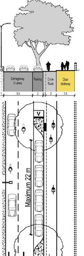
15 Guidelines Bicycle Track Parking Source: Urban Street Design Guidelines, Pune

16 Guidelines Existing and Redesigned Bus Shelters Source: Safe Access to Mass Transit Stations in Indian Cities, EMBARQ India
 Width of intersection is available for the bus to pull away from curb and re-enter traffic (3) Eliminates the potential for double stopping / parking Disadvantages: Increases sight distance")
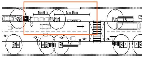
17 Guidelines Complete Street Design Near Intersection Advantages: Minimizes inference when traffic is heavy in the farside of the intersection (1) Allows passengers to board bus closest to crosswalk (2) Width of intersection is available for the bus to pull away from curb and re-enter traffic (3) Eliminates the potential for double stopping / parking Disadvantages: Increases sight distance problems for crossing pedestrians Source: Urban Street Design Guidelines, Pune
 Disadvantages: Requires additional curb space for no-parking restriction.")
18 Guidelines Complete Street Design Mid Block Advantages: Passenger waiting areas experience less pedestrian congestion (1) Minimizes sight distances problems for vehicles and pedestrians May result in less interference with traffic flow (2) Disadvantages: Requires additional curb space for no-parking restriction. Encourages passengers to cross street at mid block (jaywalking) Source: Urban Street Design Guidelines, Pune

19 Guidelines Multi-Functional Zone (MFZ) Multi-Functional Zones on a Street should be a minimum of 1.8 m wide and may locate multiple functions. Provisions of MFZ is most critical otherwise the uses / components of streets would encroach upon pedestrian, NMV or carriageway space. Common Utility Ducts and Duct Banks should not be located under the MFZ as there may be inference due to trees. Source: Street Design Guidelines UTTIPEC, DDA 2009

20 Guidelines Continuous Pavement Source: Street Design Guidelines UTTIPEC, DDA 2009


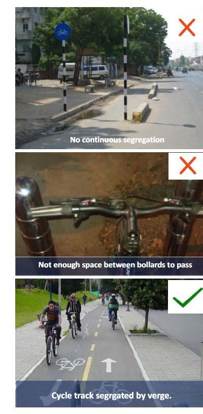
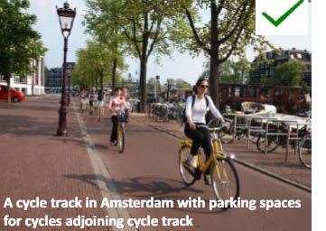
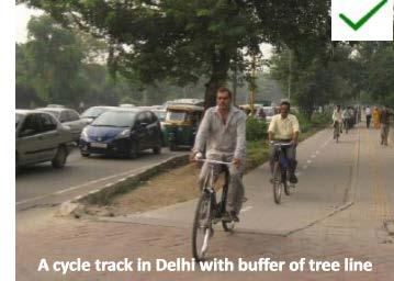
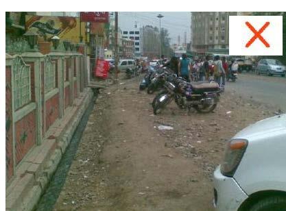
21 Guidelines Two Wheeler - Lane Segregation Recommendation from the Study Segregated Lanes in Taiwan and Malaysia (Source: Hsu et.al., 2003) Study Trap length with grids superimposed on it : Case Study Kochi, Kerala Source: SPA Delhi, 2017


22 Case Study Location Road Hierarchy Source: Street Design Guidelines UTTIPEC, DDA 2009

23 Land use of Vikas Marg

24 Case Study Location Modal Share of Delhi Vehicular Composition of Vikas Marg Source: Street Design Guidelines UTTIPEC, DDA 2009 Source: SPA, Delhi, 2016.

25 Vikas Marg: Overview
26 Traffic Characteristics VEHICLE TYPE TRAFFIC COUNTS AT LAXMI NAGAR FROM 9AM TO 10AM- TOWARDS ITO COUNTS PASSENGER CAR EQUIVALENT FACTOR PCU VALUE BUS TRUCK MINI BUS CYCLE RICKSHAW CYCLES THREE WHEELERS CARS TWO WHEELERS LCVs TOTAL
27 Traffic Characteristics VEHICLE TYPE TRAFFIC COUNTS AT LAXMI NAGAR FROM 9AM TO 10AM- TOWARDS PREET VIHAR COUNTS PASSENGER CAR EQUIVALENT FACTOR PCU VALUE BUS TRUCK MINI BUS CYCLE RICKSHAW CYCLES THREE WHEELERS CARS TWO WHEELERS LCVs TOTAL
28 Case Study Location Vikas Marg is one of the busiest road stretch located in the National Capital. Vikas Marg is located in Zone E Trans Yamuna Zone comprising of 8797 Ha. Average vehicular speed during peak hours at Vikas Marg is 8 to 10 km/hr. Road section between Laxmi Nagar Chungi to Karkari Mor (approximately 3 kms) located at Vikas Marg is considered as the study location. This road stretch is occupiedwith commercial hub on both the sides. This street lacks the design guidelines for Public Transport (PT) and the provision for Equitable Street.

29 Streetscaping: Objectives Equitable Allocation & Efficient Use of Space Improved Road Geometry Safety Decongestion of Intersections Improved Urban Aesthetics
 Encourage the use of Non-motorised")

30 Streetscaping: Objectives (Contd..) Encourage the use of Non-motorised Vehicles, Public Transport & Walking Accessible to persons with Disabilities User-friendly
31 SAFE INTERSECTIONS Making Intersections Safe for All Users

32 Intersections in Delhi: Key Issues Lack of Safe Pedestrian Crossings, Footpaths & Refuges Missing Road Markings, Signage and Signals Poor Road Geometry Lack of facilities for Non-motorised Vehicles & Pedestrians Termination of Service Lanes at Junctions Parking close to intersections hinder movement Poor condition of street, kerbs and street furniture Barrier-Free Movement not possible

33 Separation of MV & NMV Traffic MV Lanes NMV Lane

34 Alignment of Lanes at Junctions BICYCLE BOXES

35 Wide Footpaths & Pedestrian Crossings
36 Table Top with Change of Material for Traffic Calming at Free-Left Turns


37 Raised Pedestrian Crossings/ Traffic Calming

38 Street Layout: Laxmi Nagar Metro Station (Existing)

39 Laxmi Nagar Metro Station (Existing)


40 Laxmi Nagar Metro Station Junction Plan: Proposed

41 Laxmi Nagar Metro Station Junction Proposed

42 Street Layout : Nirman Vihar Metro Station (Existing)

43 Nirman Vihar Metro Station(Existing)

44 Street Section: Nirman Vihar Metro Station(Proposed)

45 Street Layout : Near Nirman Vihar Metro Station (Proposed)
46 Street Layout: Between Nirman Vihar & Preet Vihar Metro Station (Existing)

47 Street Section: Between Nirman Vihar & Preet Vihar Metro Station (Proposed)


48 Street Layout : Between Nirman Vihar & Preet Vihar Metro Station (Proposed)

49 Street Layout: Karkari Mor (Existing)

50 Karkari Mor (Existing)

51 Street Layout: Karkari Mor (Proposed)
52 Street Components
53 List of Key Street Components/Elements 1. Bus stops 2. MV Parking (4wheeler) 3. MV Parking (2wheeler) 4. Bicycle Parking 5. Auto-rickshaw stand 6. Cycle-rickshaw stand 7. E-Rickshaw Stand 8. Gramin Sewa/Phat Phat Sewa Stands 9. Parking for Police & Emergency Vehicles 10. Public Toilets 11. Drinking Water Points 12. KiosksStreet Vending Zones 13. Street Vending Zones 14. Parklets 15. Security/Police Booths 16. Mohalla Clinics 17. Aam Admi Canteens 18. Community Library & Notice Board 19. Trees with Tree Gratings & Tree Guards 20. Planters 21. Benches & Seating 22. Bollards 23. Paving Patterns 24. Kerb cuts & Tactile Paving 25. Refurbishment of Pedestrian Subways & Over-bridges 26. Maps & Signage


54 Redesigned Bus Shelters in Vikas Marg
55 Proposed Public Toilets
56 Proposed Police Booth
57 Thanks
Urban Street Design and Development
 Urban Street Design and Development Ashok Bhattacharjee, Advisor, Clean Air and Sustainable Mobility, Centre for Science and Environment CSE Workshop on Safe Access and Parking - Lytton Hotel, Kolkata
guide to a phased approach TRIPP
 complete street development guide to a phased approach TRIPP development phases Existing 00 months 00 crores/km Phase 0 months 0 crores/km Phase 09 months 0 to 08 crores/km Phase months 07 to crores/km
Decongestion Strategies for Delhi Roads
 PWD, Delhi 1 Presented By: Sh.Manoj Kumar(CPM); Sh.Ravi Kant (S.E); Sh.A.K.Agrawal (S.E) Public Works Department - GNCTD Agendas Main Challenges in Delhi Population, Land, Multiplicity of Authorities,
Street Design Guidelines for Greater Mumbai
 Street Design Guidelines for Greater Mumbai January 2014 STREET DESIGN GUIDELINES FOR GREATER MUMBAI Introduction While 51% of all trips in Mumbai are by walking 1, yet pedestrians are the most vulnerable
Footpath design. A guide to creating footpaths that are safe, comfortable, and easy to use
 Footpath design A guide to creating footpaths that are safe, comfortable, and easy to use November 2013 Contents Introduction / 1 Zoning system / 2 Width / 4 Height / 5 Surface / 5 Footpath elements /
Agenda. Overview PRINCE GEORGE S PLAZA METRO AREA PEDESTRIAN PLAN
 PRINCE GEORGE S PLAZA METRO AREA PEDESTRIAN PLAN May 28, 2008 Agenda Welcome and introductions Project overview and issue identification Planning context and strengths Design challenges and initial recommendations
Active Transportation Facility Glossary
 Active Transportation Facility Glossary This document defines different active transportation facilities and suggests appropriate corridor types. Click on a facility type to jump to its definition. Bike
PLANNING FOR SUSTAINABLE PEDESTRIAN INFRASTRUCTURE NALIN SINHA INITIATIVE FOR TRANSPORTATION & DEVELOPMENT PROG. (ITD), DELHI
, DELHI") PLANNING FOR SUSTAINABLE PEDESTRIAN INFRASTRUCTURE NALIN SINHA INITIATIVE FOR TRANSPORTATION & DEVELOPMENT PROG. (ITD), DELHI India s Road Network 5 million kms: Total road length 2.6 mn kms: Surfaced
PLANNING FOR SUSTAINABLE PEDESTRIAN INFRASTRUCTURE NALIN SINHA INITIATIVE FOR TRANSPORTATION & DEVELOPMENT PROG. (ITD), DELHI India s Road Network 5 million kms: Total road length 2.6 mn kms: Surfaced
Pedestrian Safety in Cities
 Pedestrian Safety in Cities Priorities for India Geetam Tiwari MoUD Chair Professor, Coordinator, TRIPP Indian Institute of Technology Delhi, India URBAN MOBILITY INDIA 2013 IIT Delhi 2013 RTI in Urban
IMPLEMENTATION. PEDESTRIAN USERS (Continued /) A: Class 2 Pedestrian / Cycle Ways. Pedestrian and Cycle Ways:
 A: Class 2 Pedestrian / Cycle Ways. Pedestrian and Cycle Ways:") A: Class 2 Pedestrian / Cycle Ways PLAN VIEW Pedestrian and Cycle Ways: Layout and Geometry (Refer to A): Walkways and cycle to be provided adjacent to all Class 2 Roads (these facilities should always
A: Class 2 Pedestrian / Cycle Ways PLAN VIEW Pedestrian and Cycle Ways: Layout and Geometry (Refer to A): Walkways and cycle to be provided adjacent to all Class 2 Roads (these facilities should always
EXECUTIVE SUMMARY: TRANSIT-ORIENTED DEVELOPMENT IN SMITHS FALLS, ONTARIO; A COMPARISON BETWEEN TWO SITES
 EECUTIVE SUMMARY: TRANSIT-ORIENTED DEVELOPMENT IN SMITHS FALLS, ONTARIO; A COMPARISON BETWEEN TWO SITES Topic and Purpose In 2007, the Mayor of Ottawa s Task Force on Transportation suggested adding a
5. RUNNINGWAY GUIDELINES
 5. RUNNINGWAY GUIDELINES These guidelines should be considered collectively when making runningway decisions. A runningway is the linear component of the transit system that forms the right-of-way reserved
Proposed. City of Grand Junction Complete Streets Policy. Exhibit 10
 Proposed City of Grand Junction Complete Streets Policy Exhibit 10 1 City of Grand Junction Complete Streets Policy Vision: The Complete Streets Vision is to develop a safe, efficient, and reliable travel
El Centro Mobility Hub
 The El Centro drive shed comprises a major portion of the El Centro downtown area, which is well served by bus routes. The proposals intend to promote use of public transit through improvements and enhancements
APPENDIX A: Complete Streets Checklist DRAFT NOVEMBER 2016
 APPENDIX A: Complete Streets Checklist DRAFT NOVEMBER 2016 Complete Streets Checklist MetroPlan Orlando s Complete Streets Checklist is an internal planning tool for staff to further implementation of
Tonight is for you. Learn everything you can. Share all your ideas.
 Strathcona Neighbourhood Renewal Draft Concept Design Tonight is for you. Learn everything you can. Share all your ideas. What is Neighbourhood Renewal? Creating a design with you for your neighbourhood.
5 CIRCULATION AND STREET DESIGN
 5 CIRCULATION AND STREET DESIGN This chapter describes circulation and streetscape improvements proposed for the Northwest Chico Specific Plan Area. It includes detailed design specifications for existing
PRINCE GEORGE S PLAZA METRO AREA PEDESTRIAN PLAN
 PRINCE GEORGE S PLAZA METRO AREA PEDESTRIAN PLAN May 28, 2008 Agenda Welcome and introductions Project overview and issue identification Planning context and strengths Design challenges and initial recommendations
Item to be Addressed Checklist Consideration YES NO N/A Required Description Complete Streets Guidelines
 Passaic County Complete Streets Checklist - Concept Development Project Name Item to be Addressed Checklist Consideration YES NO N/A Required Description Complete Streets Guidelines Existing Plans Have
Transport Interchange as city centres of activity. Planning approach Case Study Naya Raipur Chhattisgarh, India. Winter University 2015 IRKUTSK
 Transport Interchange as city centres of activity Planning approach Case Study Naya Raipur Chhattisgarh, India Winter University 2015 IRKUTSK Dilip Shekdar Architect and Planner, Consultant Naya Raipur
PEDESTRIAN WALKWAYS ( ZONES)
") PEDESTRIAN WALKWAYS ( ZONES) Ar. Navin Gupta Assistant Professor, School of Architecture & Landscape Design, Shri Mata Vaishno Devi University, Kakryal, Katra, Jammu & Kashmir 182320, India. ---------------------------------------------------------***--------------------------------------------------------
PEDESTRIAN WALKWAYS ( ZONES) Ar. Navin Gupta Assistant Professor, School of Architecture & Landscape Design, Shri Mata Vaishno Devi University, Kakryal, Katra, Jammu & Kashmir 182320, India. ---------------------------------------------------------***--------------------------------------------------------
Improving Public Spaces in Chennai
 Improving Public Spaces in Chennai Pedestrian Facilities and Pedestrianisation 3 September 2013 Mr Nandakumar Mr Nandakumar Executive Engineer Corporation of Chennai Maintenance and Status The Hon ble
INDEX. Geometric Design Guide for Canadian Roads INDEX
 Acceleration lane, see Lanes, Acceleration Access, 8.1 Access Management and Functional Classification 8.2 Access Management by Design Classification 8.3 Access Configuration 8.4 Building Set-Back Guidelines
STEERING COMMITTEE MEETING June 17, Streetscape Overview Burlington Comprehensive Master Plan
 STEERING COMMITTEE MEETING June 17, 2015 Streetscape Overview Burlington Comprehensive Master Plan 1 Introduction Slide This slide show was presented to the Burlington Steering Committee on June 17, 2015
CURBSIDE ACTIVITY DESIGN
 5 CURBSIDE ACTIVITY DESIGN This chapter provides design guidance for separated bike lanes adjacent to curbside activities including parking, loading and bus stops. Typical configurations are presented
MOBILITY CHALLENGES IN HILL CITIES
 MOBILITY CHALLENGES IN HILL CITIES Lalmuansanga Ralte, MCS Pvt Secretary to Minister & Under Secretary Urban Development & Poverty Alleviation Department Govt. of Mizoram DEMOGRAPHIC OVERVIEW INDIA MIZORAM
7/23/2017 VIA . Michael Hanebutt City of Sacramento Community Development Department 300 Richards Boulevard, 3 rd Floor Sacramento, CA 95811
 7/23/2017 VIA EMAIL Michael Hanebutt City of Sacramento Community Development Department 300 Richards Boulevard, 3 rd Floor Sacramento, CA 95811 RE: 65 th Street Apartments (DR17-220) Dear Mr. Hanebutt:
5/31/2016 VIA . Arwen Wacht City of Sacramento Community Development Department 300 Richards Blvd., 3 rd Floor Sacramento, CA 95811
 5/31/2016 VIA EMAIL Arwen Wacht City of Sacramento Community Development Department 300 Richards Blvd., 3 rd Floor Sacramento, CA 95811 RE: El Pollo Loco (P16-028) Dear Ms. Wacht: WALKSacramento has reviewed
o n - m o t o r i z e d transportation is an overlooked element that can greatly enhance the overall quality of life for the community s residents.
 N o n - m o t o r i z e d transportation is an overlooked element that can greatly enhance the overall quality of life for the community s residents. 84 Transportation CHAPTER 11 INTRODUCTION Transportation
Clackamas County Comprehensive Plan
 ROADWAYS The County s road system permits the movement of goods and people between communities and regions, using any of a variety of modes of travel. Roads provide access to virtually all property. They
Omaha s Complete Streets Policy
 Omaha s Complete Streets Policy (Adopted August 2015) VISION To create great places and enhance our quality of life, the City of Omaha will provide safe, accessible streets for all users. Complete Streets
David Hung, Associate Planner City of Sacramento Community Development Department 300 Richards Boulevard, 3 rd Floor Sacramento, CA
 June 13, 2016 VIA EMAIL David Hung, Associate Planner City of Sacramento Community Development Department 300 Richards Boulevard, 3 rd Floor Sacramento, CA 959811 RE: Fire Station 14 (DR16-128) Dear Mr.
Roadways. Roadways III.
 Introduction 97 Roadway Design Principles 98 Safe Speeds 99 Optimizing of Street Space 00 Minimum Lane Widths in the City of Boston 02 Design Features that Reduce Operating Speeds 05 Travel Lanes Transit
IMPLEMENTATION. PEDESTRIAN USERS (Continued /) Building Frontages: A: Stair Applications. Geometry (Accessed from the Sidewalk) Refer to A:
 Building Frontages: A: Stair Applications. Geometry (Accessed from the Sidewalk) Refer to A:") A: Stair Applications Building Frontages: Geometry (Accessed from the Sidewalk) Refer to A: Ramps should be provided for disabled users at 1:12 (8.3%) gradient. Ramp rises should be stepped at 400mm intervals.
A: Stair Applications Building Frontages: Geometry (Accessed from the Sidewalk) Refer to A: Ramps should be provided for disabled users at 1:12 (8.3%) gradient. Ramp rises should be stepped at 400mm intervals.
WELCOME. Thank you for joining us at the Second Public Workshop for the Carlsbad Pedestrian Master Plan. We look forward to receiving your feedback.
 City of Carlsbad Pedestrian Master Plan: WELCOME WELCOME Please Sign In Provide Input at Flip Charts Review Boards Presentation of Draft Plan Thank you for joining us at the Second Public Workshop for
NJDOT Complete Streets Checklist
 Background The New Jersey Department of Transportation s Complete Streets Policy promotes a comprehensive, integrated, connected multi-modal network by providing connections to bicycling and walking trip
TRAVEL PLAN: CENTRAL EUROPEAN UNIVERSITY CAMPUS REDEVELOPMENT PROJECT TRAVEL PLAN. Central European University Campus Redevelopment Project.
 TRAVEL PLAN Central European University Campus Redevelopment Project Page 1 Table of Contents Introduction... 3 Background... 7 Building Users... 7 Transportation in Community Consultation... 7 Summary
SAN FRANCISCO MUNICIPAL TRANSPORTATION AGENCY
 THIS PRINT COVERS CALENDAR ITEM NO. : 10.2 DIVISION: Sustainable Streets BRIEF DESCRIPTION: SAN FRANCISCO MUNICIPAL TRANSPORTATION AGENCY Adopting Conceptual Proposal for Streetscape Improvements to Broadway,
Complete Streets. Designing Streets for Everyone. Sarnia
 Complete Streets Designing Streets for Everyone Sarnia Complete Streets ~ Sarnia ~ 2018 Introduction Our City is made up of a network of streets that we use to go for a walk, cycle to work, drive to the
Ajax: The Road to Complete Streets
 Ajax: The Road to Complete Streets Hubert Ng, Senior Transportation Planner Elysia Leung, Transportation Demand Management Coordinator Complete Streets Forum October 1, 2015 Overview 1 2 Introduction to
OCTOBER 3, 2016 DRAFT URBAN CYCLING DESIGN GUIDELINES COMPREHENSIVE BICYCLE PLAN FOR PUNE
 OCTOBER 3, 2016 DRAFT URBAN CYCLING DESIGN GUIDELINES COMPREHENSIVE BICYCLE PLAN FOR PUNE Index 1. Introduction... 4 2. Cycling-inclusive planning and design... 5 2.1 Introduction... 5 2.2 Demotorization
Figure 5-1 Complete Street Zones. Roadside. May include frontage, pedestrian throughway, furnishings and curbside areas.
 Design Guidelines 5 The design guidelines presented in this section provide descriptions related to the form and function of the four Complete Streets zones: roadside, parking, roadways and lanes, median,
Implementing Complete Streets in Ottawa. Project Delivery Process and Tools Complete Streets Forum 2015 October 1, 2015
 Implementing Complete Streets in Ottawa October 1, 2015 The Essentials Complete Streets Implementation Framework will become part of the routine delivery of City transportation projects Approach uses every
DESIGN CODE. Enterprise West Harlow London Road North Design Code 21
 DESIGN CODE Enterprise West Essex @ Harlow London Road North Design Code 21 4 MAXIMUM BUILDING HEIGHTS 4.1 Table 4A sets out maximum building height standards for each character area within the LDO boundary.
Supporting Safer Cities. ENHANCING LAST MILE CONNECTIVITY a safety analysis of the Mandi House Metro Station
 Supporting Safer Cities ENHANCING LAST MILE CONNECTIVITY a safety analysis of the Mandi House Metro Station This Report has been prepared as part of the Project being undertaken with NDMC to Enhance the
Cycle Track Design Best Practices Cycle Track Sections
 Design Best Practices Sections It is along street segments where the separation and protection methods of cycle tracks offer more comfort than conventional bicycle lanes, and are more attractive to a wide
Re-Engineering Transport Designs for Safe and Universal Accessibility. Dr. Sewa Ram School of Planning and Architecture New Delhi
 Re-Engineering Transport Designs for Safe and Universal Accessibility Dr. Sewa Ram School of Planning and Architecture New Delhi Approach towards safe mobility What is Accessibility? Access +Ability Measuring
Role of Non-motorized Transport in Million plus Cities
 Role of Non-motorized Transport in Million plus Cities Dr. Pawan Kumar, Asstt. T&CP Town & Country Planning Organization Ministry of Urban Development,Govt. of India, New Delhi Email: pawan612@gmail.com
Corpus Christi Metropolitan Transportation Plan Fiscal Year Introduction:
 Introduction: The Safe, Accountable, Flexible, Efficient Transportation Equity Act: A Legacy for Users (SAFETEA-LU) has continued the efforts started through the Intermodal Surface Transportation Efficiency
TRANSPORT AND MOVEMENT
 TRANSPORT AND MOVEMENT Movement Strategy Public Transport Cycling and Walking Road Network Parking Standards Transport Impact Assessments Traffic Management Policies DRAFT POOLBEG PLANNING SCHEME Movement
TRANSP RTATION PLAN MOVING RED DEER FORWARD
 MULTIMODAL TRANSP RTATION PLAN MOVING RED DEER FORWARD RED DEER 2017 CONTENTS EXECUTIVE SUMMARY EXECUTIVE SUMMARY...3 MOVING FORWARD: OVERVIEW...4 Background... 5 Benefits of the Plan... 6 MOVING FORWARD:
10 SHERFORD Town Code
 Key Fixes (Ref: Masterplan Book, section 4a. Land Use Budget and Key Fixes ) The Town Plan designs and allocates buildings, streets and spaces as accurately as possible in the understandable absence of
Solana Beach Comprehensive Active Transportation Strategy (CATS)
") Solana Beach Comprehensive Active Transportation Strategy (CATS) 3.0 Goals & Policies The Solana Beach CATS goals and objectives outlined below were largely drawn from the Solana Beach Circulation Element
Solana Beach Comprehensive Active Transportation Strategy (CATS) 3.0 Goals & Policies The Solana Beach CATS goals and objectives outlined below were largely drawn from the Solana Beach Circulation Element
5. MODIFICATIONS AT JEANNE D ARC BOULEVARD/REGIONAL ROAD 174 INTERCHANGE INTERSECTION - PUBLIC HEARING COMMITTEE RECOMMENDATION
 5. MODIFICATIONS AT JEANNE D ARC BOULEVARD/REGIONAL ROAD 174 INTERCHANGE INTERSECTION - PUBLIC HEARING COMMITTEE RECOMMENDATION Having held a public hearing, that Council approve the preliminary designs
Aurora Urban Street Standards For Transit Oriented Developments and Urban Centers
 Aurora Urban Street Standards For Transit Oriented Developments and Urban Centers I. Purpose These standards will be applied to create a safe, comfortable, pleasant and pedestrian-friendly multi-modal
LEA BRIDGE ROAD - A STREET FOR EVERYONE Public consultation document
 LEA BRIDGE ROAD - A STREET FOR EVERYONE Public consultation document TELL US Bakers Arms to Leyton Green Road (Section D, E, F) Leyton Green Road to Whipps Cross Roundabout (Section G) YOUR VIEWS www.enjoywalthamforest.co.uk
Developing a Birmingham Transport Space Allocation policy. David Harris Transport Policy Manager Economy Directorate Birmingham City Council
 Developing a Birmingham Transport Space Allocation policy David Harris Transport Policy Manager Economy Directorate Birmingham City Council Birmingham s Sustainable Urban Mobility Plan Birmingham Connected
Appendix 3 Roadway and Bike/Ped Design Standards
 Appendix 3 Roadway and Bike/Ped Design Standards OTO Transportation Plan 2040 4/20/2017 Page A3-1 Adopted Standards The adopted OTO Design Standards and Major Thoroughfare Plan are contained herein.
Cluster 5/Module 2 (C5/M2): Pedestrians and Transit Oriented Development (TOD)
: Pedestrians and Transit Oriented Development (TOD)") 1 Cluster 5/Module 2 (C5/M2): Pedestrians and Transit Oriented Development (TOD) This presentation is one of the support materials prepared for the capacity building program Building Leaders in Urban Transport
1 Cluster 5/Module 2 (C5/M2): Pedestrians and Transit Oriented Development (TOD) This presentation is one of the support materials prepared for the capacity building program Building Leaders in Urban Transport
BRT Corridor Shastri Park Karawal Nagar Yamuna Vihar Mori Gate Gandhi Nagar
 Delhi Integrated Multi Modal Transit System Ltd. BRT Corridor Shastri Park Karawal Nagar Yamuna Vihar Mori Gate Gandhi Nagar Presentation to Governing Body UTTIPEC DDA March,2011 NARELA BRT PHASE II PUTHKHURD
6/22/2018 VIA . Darcy Goulart, Planning Manager City of Rancho Cordova Planning Department 2729 Prospect Park Drive Rancho Cordova, CA 95670
 6/22/2018 VIA EMAIL Darcy Goulart, Planning Manager City of Rancho Cordova Planning Department 2729 Prospect Park Drive Rancho Cordova, CA 95670 RE: Quick Quack Car Wash (DD9801) Dear Ms. Goulart: WALKSacramento
Ocean Park Boulevard Green Street Project Alternatives & Trade Offs
 Planning Commission March 4, 2009 Ocean Park Boulevard Green Street Project Alternatives & Trade Offs Purpose of Tonight s Meeting Review concept plans and options Provide input on alternatives and trade-offs
In station areas, new pedestrian links can increase network connectivity and provide direct access to stations.
 The Last Mile Planning for Pedestrians Planning around stations will put pedestrians first. Making walking to stations safe and easy is important; walking will be a part of every rapid transit Accessible
Vision: Traditional hamlet with an attractive business/pedestrian friendly main street connected to adjacent walkable neighborhoods
 N D. Focus Area II Vision: Traditional hamlet with an attractive business/pedestrian friendly main street connected to adjacent walkable neighborhoods Transit Road Focus Area II is located in the Hamlet
9. TRANSIT ACCOMMODATIONS
 9. TRANSIT ACCOMMODATIONS INTRODUCTION... 1 FDOT District Four Facilities Guidelines... 1 ESSENTIAL PRINCIPLES OF DESIGNING STREETS FOR TRANSIT... 1 ACCESS TO TRANSIT... 2 BUS STOPS... 3 Layout... 3 -Specific
9. TRANSIT ACCOMMODATIONS
 9. TRANSIT ACCOMMODATIONS INTRODUCTION...1 Broward County County-Wide Community Design Guidebook...1 FDOT District Four Transit Facilities Guidelines...2 ESSENTIAL PRINCIPLES OF DESIGNING STREETS FOR TRANSIT...3
Lawrence Avenue Streetscape Concepts August 30, 2011
 Lawrence Avenue Streetscape Concepts August 30, 2011 Neighborhood Context Phase II: River to Western Ave. Phase I: Western Ave. to Clark St. Key Map Lawrence Ave. Existing Streetscape Conditions East of
Public Transport as a Necessity for Active Transport
 03.05.2017 Seite 1 Public Transport as a Necessity for Active Transport Manfred Breithaupt Urban Transport Consultant to GIZ Active Transport requires an attractive Public Transport System and its Integration
Chapter 2: Standards for Access, Non-Motorized, and Transit
 Standards for Access, Non-Motorized, and Transit Chapter 2: Standards for Access, Non-Motorized, and Transit The Washtenaw County Access Management Plan was developed based on the analysis of existing
GENERAL. 1. Description
 GENERAL 1. Description This standard identifies minimum requirements that shall be met for all Bus Stops in the design and construction of elements for Arlington County Horizontal Design Standards. This
Community Task Force November 15, 2017
 Community Task Force November 15, 2017 Welcome and Introductions Project Partners Regional Transportation District (RTD) Colorado Department of Transportation (CDOT) Denver Regional Council of Governments
Moving Cambridge. City of Cambridge Transportation Master Plan Public Consultation Centre. March 7, :00 8:00 PM.
 City of Cambridge Transportation Master Plan Public Consultation Centre March 7, 2018 5:00 8:00 PM Region of Waterloo City of Cambridge Transportation Master Plan Public Consultation Centre March 7, 2018
8/31/2016 VIA . RE: Freeport Arco Fuel Station (P16-039)
") 8/31/2016 VIA EMAIL Garrett Norman, Assistant Planner City of Sacramento Community Development Department 300 Richards Boulevard, 3 rd Floor Sacramento, CA 95811 RE: Freeport Arco Fuel Station (P16-039)
8/31/2016 VIA EMAIL Garrett Norman, Assistant Planner City of Sacramento Community Development Department 300 Richards Boulevard, 3 rd Floor Sacramento, CA 95811 RE: Freeport Arco Fuel Station (P16-039)
Manila-Quezon City. My City Initiative Delhi. A Safety Analysis. a project by World Vision India
 Manila-Quezon City A Safety Analysis My City Initiative Delhi a project by World Vision India Safetipin, in collaboration with World Vision India, conducted safety audits in Lalbagh and Madanpur Khadar.
S T A T I O N A R E A P L A N
 The Circulation and Access Plan describes vehicle, pedestrian, and transit improvements recommended within the Concept Plan. In order to create and sustain a vibrant business district that provides pedestrian-friendly
Analysis of Unsignalized Intersection
 International Journal of Constructive Research in Civil Engineering (IJCRCE) Volume 2, Issue 1, 2016, PP 30-36 ISSN 2454-8693 (Online) www.arcjournals.org Analysis of Unsignalized Intersection B.Ramkumar
C C C
 C-012-001 Thank you for your support for the creation of new public space and nonmotorized access between downtown and the waterfront through the Overlook Walk, the East-West Connections, and the Promenade.
Transportation Assessment
 Transportation Assessment Midtown Open House February 10, 2018 Overview Midtown in Focus Overview & Purpose of Today Transportation Assessment overview Summary of Transportation work to date Review & Analysis
NEIGHBOURHOOD DEVELOPMENT PLAN: Project update. Case: HSR Layout, Bangalore. August,2013
 NEIGHBOURHOOD DEVELOPMENT PLAN: Project update Case: HSR Layout, Bangalore August,2013 Project 1: Safe and complete roads Project 2: Connected open spaces Source:www.ca-city.com complete street design
TEAM: ROAD: SECTION: K K Nagar Walkability Survey 19 th June 2013
 K K Nagar Walkability Survey 19 th June 2013 TEAM: ROAD: SECTION: Length of surveyor s foot in cms. (any one): (this surveyor will measure distances required in Table II and points 2.c and 4.a in Table
Classification Criteria
 SCHEDULE D TO RECOMMENDED OFFICIAL PLAN AMENDMENT NO. 40 SCHEDULE C-4 Road Criteria Criteria Traffic Service Objective Land Service/Access Typical Daily Traffic Volume Flow characteristics Travel Speed
What Is a Complete Street?
 Session 5 Charleen Zimmer, AICP, Zan Associates May 5-7, 2010 What Is a Complete Street? May 2010 5-1 Not a Complete Street More of a Complete Street May 2010 5-2 Benefits of Complete Streets Safety for
PESHAWAR Bus Rapid TRANSIT. By Engr. Haroon Rashid Ph. D Scholar, MS in Transportation Planning and B.Sc Civil Engineering
 PESHAWAR Bus Rapid TRANSIT By Engr. Haroon Rashid Ph. D Scholar, MS in Transportation Planning and B.Sc Civil Engineering 1 OUTLINE Aim and Objective What is BRT? Why BRT? BRT as High Performance Transit
Prince George s County plans, policies, and projects
 Prince George s County plans, policies, and projects Over 250 projects for trails, bikeways, designated bike lanes and sidewalk construction Trail projects that improve access to Metro Sidewalk and trail
10/30/2012 VIA
 10/30/2012 VIA EMAIL David Hung, Associate Planner Community Development Department, Current Planning Division City of Sacramento 300 Richards Blvd., 3 rd Floor Sacramento, CA 95811 RE: The Cannery On-Site
SMART INDUSTRIAL PARK
 MP AUDYOGIK KENDRA VIKAS NIGAM (I) LTD., INDORE (M.P.) SMART INDUSTRIAL PARK Near NATRIP - Pithampur Project Consultant Mehta and Associates, Indore Architects & Urban Planners Proposed site for Smart
CHAPTER 7.0 IMPLEMENTATION
 CHAPTER 7.0 IMPLEMENTATION Achieving the vision of the Better Streets Plan will rely on the ability to effectively fund, build and maintain improvements, and to sustain improvements over time. CHAPTER
10/8/2014 VIA . RE: CVS Pharmacy (P13-002) Revised August 2014
 Revised August 2014") 10/8/2014 VIA EMAIL David Hung, Associate Planner Community Development Department, Current Planning Division City of Sacramento 300 Richards Boulevard, 3 rd Floor Sacramento, CA 95811 RE: CVS Pharmacy
10/8/2014 VIA EMAIL David Hung, Associate Planner Community Development Department, Current Planning Division City of Sacramento 300 Richards Boulevard, 3 rd Floor Sacramento, CA 95811 RE: CVS Pharmacy
Pedestrian Project List and Prioritization
 To: Kyle Wagenschutz, City of Memphis CC: From: Anne Conlon and John Cock, Alta Planning + Design Date: December, 2014 Re: Project List Development (Task 3.1-3.2) and Project List Prioritization (Task
INDOT Complete Streets Guideline & Policy
 INDOT Complete Streets Guideline & Policy INTRODUCTION The Complete Streets guidelines build upon multiple efforts and promote a multimodal transportation system that is integrated and sustains land use
8/1/2018 VIA . Darcy Goulart City of Rancho Cordova Planning Department 2729 Prospect Park Drive Rancho Cordova, CA 95670
 8/1/2018 VIA EMAIL Darcy Goulart City of Rancho Cordova Planning Department 2729 Prospect Park Drive Rancho Cordova, CA 95670 RE: Towne Place Suites by Marriott Hotel (DD9806) Dear Ms. Goulart: WALKSacramento
CHECKLIST 2: PRELIMINARY DESIGN STAGE AUDIT
 CHECKLIST 2: PRELIMINARY DESIGN STAGE AUDIT 2.1 General topics 2.1.1 Changes since previous audit Do the conditions for which the scheme was originally designed still apply? (for example, no changes to
Anniedale- Tynehead NCP Best Practices in Transportation Planning Summary
 Anniedale- Tynehead NCP Best Practices in Transportation Planning Summary The City of Surrey Anniedale-Tynehead NCP Best Practices Transportation Summary This document provides a summary of the Bunt &
Brooklyn Boulevard (County Road 152) Reconstruction Project Phase I. OPEN HOUSE June 20, 2017
 Reconstruction Project Phase I. OPEN HOUSE June 20, 2017") Brooklyn Boulevard (County Road 152) Reconstruction Project Phase I OPEN HOUSE June 20, 2017 Brooklyn Boulevard (County Road 152) Phase I Project Partners Project Lead Other Project Partners include Brooklyn
Brooklyn Boulevard (County Road 152) Reconstruction Project Phase I OPEN HOUSE June 20, 2017 Brooklyn Boulevard (County Road 152) Phase I Project Partners Project Lead Other Project Partners include Brooklyn
KIGALI CITY, RWANDA MODERNIZATION OF TRANSPORT INFRASTRUCTURE AND SERVICES. Presentation to ITC, UTwente Enschede 13 June 2018
 KIGALI CITY, RWANDA MODERNIZATION OF TRANSPORT INFRASTRUCTURE AND SERVICES Presentation to ITC, UTwente Enschede 13 June 2018 Dr. Eng. Alphonse NKURUNZIZA City Engineer, City of Kigali Kigali City Projected
Watertown Complete Streets Prioritization Plan. Public Meeting #1 December 14, 2017
 Watertown Complete Streets Prioritization Plan Public Meeting #1 December 14, 2017 Goals for Public Meeting Overview of MassDOT Complete Streets Funding Program Educate the community on Complete Streets
2.0 LANE WIDTHS GUIDELINE
 2.0 LANE WIDTHS GUIDELINE Road Engineering Design Guidelines Version 2.0.1 May 2018 City of Toronto, Transportation Services City of Toronto Page 0 Background In early 2014, Transportation Services initiated
URBAN AGE CONFERENCE GOVERNING URBAN FUTURES
 URBAN AGE CONFERENCE GOVERNING URBAN FUTURES November 2014 Geetam Tiwari Indian Institute of Technology, Delhi The Delhi BRT experience: 1994 to 2014 All rights are reserved by the presenter www.lsecities.net
Streetscape: Core Shopping District
 Streetscape: Core Shopping District DRAFT DRAFT DRAFT May 00 Core Shopping District: Phase Blue Island s Core Shopping District is located along Western Avenue, between Grove and Union Streets. Streetscape
Minta Farm Berwick S96A Transport Impact Assessment
 Minta Farm Berwick S96A Transport Impact Assessment 170310TIA001I-F 4 October 2017 onemilegrid ABN: 79 168 115 679 (03) 9939 8250 1/59 Keele Street COLLINGWOOD, VIC 3066 www.onemilegrid.com.au DOCUMENT