BRT Corridor Shastri Park Karawal Nagar Yamuna Vihar Mori Gate Gandhi Nagar
|
|
|
- Phebe Fox
- 6 years ago
- Views:
Transcription

1 Delhi Integrated Multi Modal Transit System Ltd. BRT Corridor Shastri Park Karawal Nagar Yamuna Vihar Mori Gate Gandhi Nagar Presentation to Governing Body UTTIPEC DDA March,2011

2 NARELA BRT PHASE II PUTHKHURD BAKHTAWARPUR BRT PHASE III BAWANA BRT PHASE IV IBRAHIMPUR SG TPT NAGAR MUKUNDPUR KARAWAL NAGAR Project Corridor KANJHAWALA JAHANGIRPURI MADHUBAN CHOWK AZADPUR GOKALPURI DELHI BORDER NAJAFGARH MUNDKA DABRI MOD PUNJAB I BAGH TILAK NAGAR SHAKUR BASTI KIRBI PLACE GULABIBAGH NEW PATEL NAGAR DHAULAKUAN ISBT KASHMERE GATE AZAD MARKET SHAHI IDGAH DELHI GATE CONNAUGH T PLACE IG CENTRA L SECTT STADIUM NAT. STADIUM GANDHI NAGAR KARKARI MOR DILSHAD GARDEN ISBT ANAND VIHAR (TATA TELCO) GAZIPUR KONDALI GOPALNAGAR PALAM MOR JOR BAGH S KALE KHAN CHILLA TO NOIDA AIRPORT MOOLCHAND SUKHDEV VIHAR KHAIRA IIT OKHLA PH II CHHAWLA KAPASHERA VASANT KUNJ RAJOKARI AMBEDKAR NAGAR SULTANPUR BADARPUR PHASING OF FUTURE BRT CORRIDORS IN DELHI


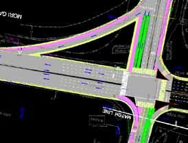
3 Corridor Location Map (On Road Map) N N N N N N N N N Karawal Nagar Khajuri Khas Junction Yamuna Vihar Mori Gate Shastri Park Junction Located in East Delhi Total Corridor Length is Kms Shastri Park Metro Stn. Gandhi Nagar The corridor connects ISBT, Gandhi Nagar (cloth market) and Metro stations.

4 Mukundpur Wazirabad FUTURE BRT CORRIDORS IN THE VICINITY OF PROPOSED CORRIDOR Karawal Nagar Khajuri Khas Yamuna Vihar Proposed Corridor, i.e. Karawal Nagar to Gandhi Nagar and Bhajanpura to Mori Gate would created integrated network by connecting future links Bhajanpur a 4 2 Mori Gate Shastri Park Gandhi Nagar 3 Dilshad Garden 1. BRT from Gandhi Nagar to Chilla 2. BRT from Mukundpur to Kondli 3. BRT form Shastri Park to Dilshad Garden 1 4. Yamuna Vihar Metro Station of Phase-III metro system Kondli Chilla

 ownership.")
5 Influence Area Characteristics: BRT Vehicle Types Distribution Car Two-Whlr Cycle Others Kilometers Corridor will Service Large Population of Influence Area. About 7.8 lac. Serves Low and low middle class household income areas having high dependence on public transport. Area has High private vehicle (2 wheeler) ownership. Important to reverse this trend by improving public transport.

6 Road Network Inventory of the corridor Length (km) Road class Lane configuration Main Corridor 8.7 Urban Highway 4 lane Link Road Urban Highway 6 lane Link Road Urban Highway 4 lane with Service Roads alongwith BRT lanes Link Road Urban Highway 4 lane with Service Roads alongwith BRT lanes LINK-2 Link Road Urban Collector BRT 2 lane (Proposed) Available Right of Ways provide opportunity to have Bus Lane Segregation without major impact on MV Lanes LINK-1 LINK-4 LINK-3
7 Vehicle composition and speed in the corridor Intersection # Ghandi Nagar Rd & Yamuna Marginal BM & Yamuna Marginal BM & GT Road Shastri Park - ISTB Rd Wazirabad Rd Mode Veh % Veh % Veh % Motorized 46, % 127, % 99, % Motorcycle 22, % 67, % 54, % Car 12, % 28, % 21, % Auto rickshaw 7, % 20, % 10, % Truck 3, % 8, % 7, % LCV Pass % 1, % 1, % LCV Freight 2, % 5, % 5, % 2 Axles % 2, % 1, % 3 Axles % % % SemiArticulat ed % % % Articulated % % % Bus % 2, % 3, % Non- Mortorized 54, % 69, % 30, % Cycle 25, % 44, % 22, % Cycle rickshaw 22, % 22, % 7, % Others 6, % 3, % % Total vehicles 101, % 197, % 129, % AVERAGE SPEED IN PEAK HOUR Modal Distribution Public Transport Auto Rickshaw Car 2 Weels Karawal Nagar to Shastri park KMPH High NMV Share Opportunity to create space for Safe Movement for NMV Kilometers Current Situation


8 Finalization of BRT Elements Running ways Terminal Vehicles Bus Rapid Transit Fare Collection Service & Operation Plan ITS ELEMENTS DESIGN TO REDUCE DELAY AND INCREASE EFFICIENCY OF BUS SYSTEM
 Pedestrian")

9 DATA BASE DEVELOPMENT PRIMARY SURVEYS SECONDARY DATA Speed and Delay Surveys Boarding / Alighting Survey Origin / Destination cum Opinion Survey Turning Movement Surveys Direction-wise Classified Traffic Volume Survey Traffic Signal Time and Saturation Flow Survey Parking Survey (on-street and off-street) Pedestrian Survey Data for Strip Plan 1. Traffic Demand Forecast Study 2. BRT Guidelines Reconnaissance Survey identification of specific / typical problem areas. Secondary data Relevant secondary data regarding, development plans, road development plans, signal phasing, ownership of land parking provision bus stop location and bus routing

 Total (pass/day) 2012")

10 Passenger Demand Forecast: BRT Line 1 and Line 2 Demand model for the current and the horizon years Line 1 (pass/day) Line 2 (pass/day) Total (pass/day) ,862 78, , ,358 90, , , , ,851

11 Estimated required fleet and headways buses will be required to serve both lines For Route 1-33 standard buses For Route 2-42 standard buses q To meet demand for critical section in peak hour-line 1- Average headway of 2 min q For Line 2, average headway of 1.8 min.
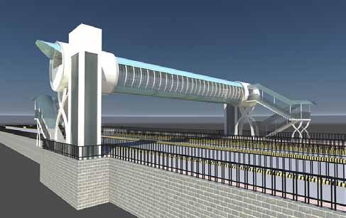
12 Karawal Nagar Proposed Corridor Plan Corridor Sections Length (Km) Bus Lane Placement Khajuri Khas Yamuna Vihar Main Corridor 8.7 Both Bus Lane on River side Link Central Lane Link Kerb Side Lane Link Central Lane Kashmere Gate Metro Station Shastri Park Jn. Link Both Bus Lane RHS Foot Over Bridge Mori Gate Shastri Park Metro Stn. Gandhi Nagar Ped. Subway Signature Bridge Metro Station
13 Proposed Cross sections

14 Karaw al Nagar TYPICAL CROSS SECTION FOR NORMAL ROAD SECTION Khaju ri Khas Juncti on Yamun a Vihar Mor i Gat e Shast ri Park Metr o Stn. Shast ri Park Juncti on Gandh i Nagar Main Corridor Between Shastri Park Junction and Khajuri Junction
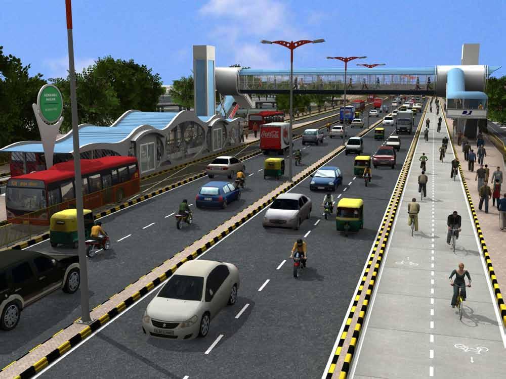
15 The corridor will have central platforms Wide NMV lane on both sides. Wide Bus queue shelters Holding area for buses Table top pedestrian crossings Two MV lanes on both sides (main corridor)
16
 - Optional Khajuri Khas Junction Yamun a Vihar Mori Gate Shastri Park Junction Shastri Park Metro Stn.")
17 HORN PLEASE EXISTING ROAD SECTION WITH MIX TRAFFIC CONDITION (GT ROAD) HORN PLEASE Karaw al Nagar PROPOSED ROAD SECTION IN SEGREGATED TRAFFIC CONDITION (GT ROAD) - Optional Khajuri Khas Junction Yamun a Vihar Mori Gate Shastri Park Junction Shastri Park Metro Stn. Gandh i Nagar GT ROAD

18 TYPICAL CROSS SECTION FOR NORMAL ROAD SECTION Karaw al Nagar Khaju ri Khas Juncti on Yamun a Vihar Mor i Gat e Shast ri Park Metr o Stn. Shast ri Park Juncti on Gandh i Nagar Main Corridor Near Shastri Park Metro Station Buland Maszid Area

19 TYPICAL CROSS SECTION FOR CENTRAL BUS LANE Karaw al Nagar Khaju ri Khas Juncti on Yamun a Vihar Mor i Gat e Shast ri Park Metr o Stn. Shast ri Park Juncti on Gandh i Nagar Near Gandhi Nagar
20 TYPICAL CROSS SECTION FOR CURB SIDE BUS LANE Karawal Nagar Khajuri Khas Junctio n Yamuna Vihar Mori Gate Shastri Park Junctio n Shastri Park Metro Stn. Gandhi Nagar
21 Depot Karawal Nagar Terminal Proposed Corridor Features Bus Stops Id Station Name 4 5 Khajuri Khas Yamuna Vihar 1 Karawal Nagar Terminal 2 Police Training Center 3 Tukmerpur 4 Rajiv Nagar 5 Kartar Nagar Transfer Station 6 Ghonda Patti 6 7 Jagjeet Nagar 8 New Usmanpura 7 9 Shastri Park 10 Buland Masjid 8 Shastri Park Jn. 11 Metro station 12 Kailash Nagar Gandhi Nagar 14 Yamuna Vihar 15 Brij Puri Mori Gate Terminal Shastri Park Metro Stn Gandhi Nagar 16 Bhajanpura 17 IT Park 18 Shastri Park Depot 19 Kashmere Gate ISBT 20 Mori Gate Terminal


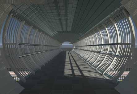
22 Modern Bus shelters and FOB


23 Karawal Nagar Proposed Corridor Features FOBs & Cycle Parking Khajuri Khas Yamuna Vihar Proposed FOB Cycle parking Shastri Park Jn. Mori Gate Shastri Park Metro Stn. Gandhi Nagar
24 Junction Improvements


25 Khajuri Khas junction Existing Condition Proposed Improvement


26 Existing Condition Shastri Park Junction Proposed Improvement


27 Existing Situation at Shastri Park-Old GT Road Crossing(Buland Masjid) Existing Condition Proposed Improvement


28 Proposals at Buland Masjid Area


29 Existing Situation Old G.T. Road Roundabout Existing Condition Proposed Improvement In critical areas BRT will run in mix traffic


30 Application of Intelligent Transport System Automatic Vehicle Location Transit Priority at Intersection ITS for Passenger Information & Fare Collection Initially. Signal Priority & AVL

31 Stakeholders Consultation Several Consultations and Joint Site Visits to Finalize and Refine Plan UTTIPEC Traffic Police
32 Thank You
Decongestion Strategies for Delhi Roads
 PWD, Delhi 1 Presented By: Sh.Manoj Kumar(CPM); Sh.Ravi Kant (S.E); Sh.A.K.Agrawal (S.E) Public Works Department - GNCTD Agendas Main Challenges in Delhi Population, Land, Multiplicity of Authorities,
Equitable Road Space : Case study Vikas Marg, New Delhi
 Equitable Road Space : Case study Vikas Marg, New Delhi Laxmi Nagar Chungi to Karkari Mor PWD, Govt. of NCT of Delhi Methodology Adopted STAGE 1 : Understand Equitable Road Space and Design STAGE 2 : Study
Low Carbon Mobility Plan For Indian Cities
 Low Carbon Mobility Plan For Indian Cities Data Requirement and BAU Scenario Workshop on Developing Policies and Strategies for Low Carbon Transport in India, 24-25 August, 2012 In Indian context NMT and
Cycling Inclusive Transport Planning
 Cycling Inclusive Transport Planning Dr. Anvita Arora, Dr. Mark Zuidgeest*, Mark Kirkels Interface for Cycling Expertise *Cycling Academic Network ADB Transport Forum, Manila Activity Clinic 11 May 27th,
Scope of the Transit Priority Project
 Transit Planning Committee #1 March 19, 2015 Scope of the Transit Priority Project Review of the 2010 plan Analysis of Transit Priority Measures Preliminary plans for rapid transit Recommendations for
BUS RAPID TRANSIT. A Canadian Perspective. McCormick Rankin International. John Bonsall P.Eng
 BUS RAPID TRANSIT A Canadian Perspective Why choose BRT? Because it is a practical and cost effective rapid transit solution for the most common types of land use in urban Canada Operating experience shows
URBAN AGE CONFERENCE GOVERNING URBAN FUTURES
 URBAN AGE CONFERENCE GOVERNING URBAN FUTURES November 2014 Geetam Tiwari Indian Institute of Technology, Delhi The Delhi BRT experience: 1994 to 2014 All rights are reserved by the presenter www.lsecities.net
No.TR/Sch/(00)/3/2014/4949 Dated:
/3/2014/4949 Dated:") No.TR/Sch/(00)/3/2014/4949 Dated: -14.11.2014 It is notified for the information of all concerned that a new route having number 33C will be introduced to operate in between Chauhan Patti and Anand Vihar
No.TR/Sch/(00)/3/2014/4949 Dated: -14.11.2014 It is notified for the information of all concerned that a new route having number 33C will be introduced to operate in between Chauhan Patti and Anand Vihar
EFFECTS OF TRANSIT SIGNAL PRIORITY ON BUS RAPID TRANSIT SYSTEM. Sahil Chawla, Shalini Sinha and Khelan Modi
 EFFECTS OF TRANSIT SIGNAL PRIORITY ON BUS RAPID TRANSIT SYSTEM Sahil Chawla, Shalini Sinha and Khelan Modi PRESENTATION STRUCTURE INTRODUCTION AIM / OBJECTIVES STUDY APPROACH LITERATURE REVIEW MODEL DEVELOPMENT
Welcome. The Brooklin Secondary Plan and Transportation Master Plan are collectively referred to as the Brooklin Study.
 Welcome The Town of Whitby is undertaking a study to prepare a Secondary Plan and Transportation Master Plan to guide and manage growth in the Brooklin area. The Brooklin Secondary Plan and Transportation
Integrated Corridor Approach to Urban Transport. O.P. Agarwal World Bank Presentation at CODATU XV Addis Ababa, 25 th October 2012
 Integrated Corridor Approach to Urban Transport O.P. Agarwal World Bank Presentation at CODATU XV Addis Ababa, 25 th October 2012 What is the Integrated Corridor Approach for Urban Transport Public? Why
NEWMARKET CENTRE Mobility Hub Profile
 Mobility Hub Profile Dundas Newmarket West-Bloor Centre Anchor Hub Gateway Hub N MOBILITY HUBS: Places of connectivity between regional and rapid transit services, where different modes of transportation
OTTAWA TRAIN YARDS PHASE 3 DEVELOPMENT CITY OF OTTAWA TRANSPORTATION IMPACT STUDY. Prepared for:
 OTTAWA TRAIN YARDS PHASE 3 DEVELOPMENT CITY OF OTTAWA TRANSPORTATION IMPACT STUDY Prepared for: The Ottawa Train Yards Inc. 223 Colonnade Road South, Suite 212 Nepean, Ontario K2E 7K3 January 17, 2012
BURGAS INTEGRATED PUBLIC TRANSPORT PROJECT. Information day, 5 th July 2011, Burgas
 BURGAS INTEGRATED PUBLIC TRANSPORT PROJECT Information day, 5 th July 2011, Burgas BRT TECHNICAL DESIGN TENDER Preliminary tender specifications and requirements Overview 1 Burgas BRT concept 2 Main outputs
Integrated Mobility Plan for Gurgaon Manesar Urban Complex
 Department of Town and Country Planning (DTCP), Government of Haryana December 2010 Integrated Mobility Plan for Gurgaon Manesar Urban Complex Support Document 5 th Floor A Wing, IFCI Tower Nehru Place
DON MILLS-EGLINTON Mobility Hub Profile
 Mobility Hub Profile Dundas Don Mills-Eglinton West-Bloor Anchor Hub Gateway Hub N MOBILITY HUBS: Places of connectivity between regional and rapid transit services, where different modes of transportation
INTEGRATED MULTI-MODAL TRANSPORTATION IN INDIA
 INTEGRATED MULTI-MODAL TRANSPORTATION IN INDIA Tejas Rawal (Corresponding Author) Ph.D. Research Scholar, Dept. of Architecture & Planning, Indian Institute of Technology-Roorkee, Roorkee-247 667 Email:
The City. Population of BH. Population of RMBH. 2.4 million inhabitants. 5.7 million inhabitants. 6.3 million trips a day
 Implementing sustainable mobility solutions Rogério Carvalho Silva Architect President Adviser BHTRANS Belo Horizonte, Brazil The City Population of BH 2.4 million inhabitants Population of RMBH 5.7 million
FIRST DELHI BRT CORRIDOR A DESIGN SUMMARY AMBEDKAR NAGAR TO DELHI GATE
 FIRST DELHI BRT CORRIDOR A DESIGN SUMMARY AMBEDKAR NAGAR TO DELHI GATE DECEMBER 2005 PROJECT TEAM TRIPP Dr. Geetam Tiwari Prof. Dinesh Mohan Mr. Sandeep Gandhi Mr. B. Sriram Ms. Sonia Kapoor Ms. Ruchi
In station areas, new pedestrian links can increase network connectivity and provide direct access to stations.
 The Last Mile Planning for Pedestrians Planning around stations will put pedestrians first. Making walking to stations safe and easy is important; walking will be a part of every rapid transit Accessible
Traffic and Transport Safety TABLE 9.5.7: LOCATION OF MAJOR PARKING PLACES IN UDAIPUR CITY TABLE 9.5.8: MODE WISE ACCIDENT TREND IN UDAIPUR
 TABLE 9.5.7: LOCATION OF MAJOR PARKING PLACES IN UDAIPUR CITY SI No. Stretch Link Length (m) Existing Parking Demand in ECS 1 Patel Chowk to Choraha 1600 291 2 Udaipol Choraha to Surajpol Choraha 530 158
Clackamas County Comprehensive Plan
 ROADWAYS The County s road system permits the movement of goods and people between communities and regions, using any of a variety of modes of travel. Roads provide access to virtually all property. They
DUNDAS WEST-BLOOR Mobility Hub Profile
 Mobility Hub Profile Dundas West-Bloor Anchor Hub Gateway Hub N MOBILITY HUBS: Places of connectivity between regional and rapid transit services, where different modes of transportation come together
BELFAST RAPID TRANSIT. Ciarán de Búrca Director, Transport Projects Division Department for Regional Development
 BELFAST RAPID TRANSIT Ciarán de Búrca Director, Transport Projects Division Department for Regional Development Objectives of Belfast Rapid Transit To provide a modern, safe, efficient and high quality
2. Context. Existing framework. The context. The challenge. Transport Strategy
 Transport Strategy Providing quality connections Contents 1. Introduction 2. Context 3. Long-term direction 4. Three-year priorities 5. Strategy tree Wellington City Council July 2006 1. Introduction Wellington
Urban Transport Service Level Benchmarking in Urban Transport for Indian Cities
 Urban Transport Service Level Benchmarking in Urban Transport for Indian Cities Ahmedabad Bhubaneswar Hubli-Dharwad Kohima Mysore Surat An Initiative of the, Government of India Presented by Prof. H.M.
Preliminary Transportation Analysis
 Preliminary Transportation Analysis Goals of a Robust, Multimodal Transportation Network Safe Accessible/Connected Efficient Comfortable Context-Sensitive Motor Vehicle: Continue to analyze the data to
Urban Street Design and Development
 Urban Street Design and Development Ashok Bhattacharjee, Advisor, Clean Air and Sustainable Mobility, Centre for Science and Environment CSE Workshop on Safe Access and Parking - Lytton Hotel, Kolkata
Roadways. Roadways III.
 Introduction 97 Roadway Design Principles 98 Safe Speeds 99 Optimizing of Street Space 00 Minimum Lane Widths in the City of Boston 02 Design Features that Reduce Operating Speeds 05 Travel Lanes Transit
Analysis of Unsignalized Intersection
 International Journal of Constructive Research in Civil Engineering (IJCRCE) Volume 2, Issue 1, 2016, PP 30-36 ISSN 2454-8693 (Online) www.arcjournals.org Analysis of Unsignalized Intersection B.Ramkumar
guide to a phased approach TRIPP
 complete street development guide to a phased approach TRIPP development phases Existing 00 months 00 crores/km Phase 0 months 0 crores/km Phase 09 months 0 to 08 crores/km Phase months 07 to crores/km
Centennial Neighbourhoods Transportation Management Plan Summary of Phase 1 Consultation. Overview of Issues
 1 Centennial Neighbourhoods Transportation Management Plan Summary of Phase 1 Consultation The Centennial Neighbourhoods Transportation Management Plan (CNTMP) is being undertaken to support the Secondary
Copenhagen Cycling Map. Red Lines Cycling facilities
 Copenhagen Cycling Map Red Lines Cycling facilities Copenhagen Cycling Facilities Design Approaches Transportation without Pollution Copenhagen s Strategy Where Cycling is one of the top key activities
Signal Optimization using PTV Vistro for a Major BRTS Corridor in Pimpri Chinchwad, Maharashtra
 Signal Optimization using PTV Vistro for a Major BRTS Corridor in Pimpri Chinchwad, Maharashtra Presented by Mr. Pratapsingh Bhonsle, P.E, PTOE Mr. Athul Suresh, Traffic Engineer 10 th UMI Conference 5/11/2017
PESHAWAR Bus Rapid TRANSIT. By Engr. Haroon Rashid Ph. D Scholar, MS in Transportation Planning and B.Sc Civil Engineering
 PESHAWAR Bus Rapid TRANSIT By Engr. Haroon Rashid Ph. D Scholar, MS in Transportation Planning and B.Sc Civil Engineering 1 OUTLINE Aim and Objective What is BRT? Why BRT? BRT as High Performance Transit
DON MILLS-SHEPPARD Mobility Hub Profile
 DON MILLS-SHEPPARD Mobility Hub Profile Dundas Don Mills-Sheppard West-Bloor Anchor Hub Gateway Hub N MOBILITY HUBS: Places of connectivity between regional and rapid transit services, where different
Konstantin Glukhenkiy Economic Affairs Officer
 Konstantin Glukhenkiy Economic Affairs Officer Rapid growth of urban areas Very rapid increase in motorisation Substantial increases in traffic congestion Relative decline of public transport usage and
Bus Rapid Transit: How Delhi Compares
 Bus Rapid Transit: How Delhi Compares Delhi BRT Modern Low Floor CNG Buses are a big improvement: Lower Particulate emissions than TransMilenio Grade A Cycling Facilities Bike flows at peak are as high
David Jickling, Public Transportation Director Regional Transportation Commission, Washoe County
 David Jickling, Public Transportation Director Regional Transportation Commission, Washoe County Virginia Street Resort corridor connecting University of Nevada, Reno Downtown Truckee River Strip Casinos
Main-McVay Transit Study: Phase 2 Options Definition and High Level Constraints Evaluation
 Main-McVay Transit Study: Phase 2 Options Definition and High Level Constraints Evaluation APRIL 2016 A collaborative study between: For Additional Information or to Comment If you would like additional
NORTH YORK CENTRE Mobility Hub Profile
 Mobility Hub Profile Dundas North York West-Bloor Centre Anchor Hub Gateway Hub N MOBILITY HUBS: Places of connectivity between regional and rapid transit services, where different modes of transportation
BELFAST ON THE MOVE Transport Masterplan for Belfast City Centre
 BELFAST ON THE MOVE Transport Masterplan for Belfast City Centre CIHT Technical Evening 23 February 2015 Ciarán de Búrca, Director Transport Projects Division Civic Spine Background Belfast Metropolitan
Contents. Champaign-Urbana Mass Transit District Stop Placement Guidelines
 Contents Champaign-Urbana Mass Transit District Introduction... 1 Stop Spacing... 2 Rural... 2 Low Density Suburban... 2 General Urban... 2 Urban Core... 2 Operational Safety... 3 Stop Placement... 4 Nearside
Better Market Street Project. Project Update January 15, 2015
 Better Market Street Project Project Update January 15, 2015 Better Market Street Project Area Limits Market Street 2.2 Miles Mission Street Better Market Street Schedule Market Street City s busiest transit
Role of Non-motorized Transport in Million plus Cities
 Role of Non-motorized Transport in Million plus Cities Dr. Pawan Kumar, Asstt. T&CP Town & Country Planning Organization Ministry of Urban Development,Govt. of India, New Delhi Email: pawan612@gmail.com
VOLUME 5 Technology and Option Evaluation
 VICTORIA REGIONAL RAPID TRANSIT Victoria / West Shore Link VOLUME 5 Technology and Option Evaluation August 2011 Prepared for BC Transit by SNC-Lavalin Inc McElhanney Consulting Services Ltd Errata 1.
UNIT V 1. What are the traffic management measures? [N/D-13] 2. What is Transportation System Management (TSM)? [N/D-14]
![UNIT V 1. What are the traffic management measures? [N/D-13] 2. What is Transportation System Management (TSM)? [N/D-14]](/thumbs/87/95571671.jpg "UNIT V 1. What are the traffic management measures? [N/D-13] 2. What is Transportation System Management (TSM)? [N/D-14]") UNIT V 1. What are the traffic management measures? [N/D-13] Some of the well-known traffic management measures are: a) Restrictions on turning movements b) One - way streets c) Tidal - flow operations
UNIT V 1. What are the traffic management measures? [N/D-13] Some of the well-known traffic management measures are: a) Restrictions on turning movements b) One - way streets c) Tidal - flow operations
PLANNING FOR SUSTAINABLE PEDESTRIAN INFRASTRUCTURE NALIN SINHA INITIATIVE FOR TRANSPORTATION & DEVELOPMENT PROG. (ITD), DELHI
, DELHI") PLANNING FOR SUSTAINABLE PEDESTRIAN INFRASTRUCTURE NALIN SINHA INITIATIVE FOR TRANSPORTATION & DEVELOPMENT PROG. (ITD), DELHI India s Road Network 5 million kms: Total road length 2.6 mn kms: Surfaced
PLANNING FOR SUSTAINABLE PEDESTRIAN INFRASTRUCTURE NALIN SINHA INITIATIVE FOR TRANSPORTATION & DEVELOPMENT PROG. (ITD), DELHI India s Road Network 5 million kms: Total road length 2.6 mn kms: Surfaced
Sixth Line Development - Transit Facilities Plan
 Memorandum Date: November 13, 2012 To: From: c.c. Subject: Rob Freeman (Freeman Planning) Kevin Phillips Sixth Line Development - Transit Facilities Plan 33016631 This memo was prepared to review the transit
BLUE SEA VILLAGE MER BLEUE 2159 MER BLEUE ROAD OTTAWA, ONTARIO TRANSPORTATION IMPACT ASSESSMENT. Prepared for: Ontario Limited.
 BLUE SEA VILLAGE MER BLEUE 2159 MER BLEUE ROAD OTTAWA, ONTARIO TRANSPORTATION IMPACT ASSESSMENT Prepared for: 2534189 Ontario Limited April 6, 2018 117-668 TIA Report_2.doc D. J. Halpenny & Associates
Frequently Asked Questions (FAQ)
") Frequently Asked s (FAQ) Study Process... 2 Rapid Transit Service and Operations... 5 Public Consultation... 8 Business Impacts... 8 Design and Property Impacts... 9 Construction Impacts...12 Traffic,
Frequently Asked s (FAQ) Study Process... 2 Rapid Transit Service and Operations... 5 Public Consultation... 8 Business Impacts... 8 Design and Property Impacts... 9 Construction Impacts...12 Traffic,
AUTOMATED AND ZERO EMISSION VEHICLES HOW THEY MIGHT RESHAPE OUR STREETS
 AUTOMATED AND ZERO EMISSION VEHICLES HOW THEY MIGHT RESHAPE OUR STREETS BACKGROUND: This study is a collaboration between Urban Circus (Visualisation) and Ethos Urban (Urban Design) Ideas were workshopped
Arterial Transitway Corridors Study. Ave
 Arterial Transitway Corridors Study Ave January 2012 Arterial Transitway Corridors Study Overview Corridor Features and Demographics 11 study corridors, 95 route miles 86,000 daily rides and half of existing
1. Introduction. 2. Survey Method. Volume 6 Issue 5, May Licensed Under Creative Commons Attribution CC BY
 A Study on Performance of an Urban Arterial Corridor Guggilla Raju 1, Rontala Ashwini 2 1 Assistant Professor, Department of Civil Engineering, GCET 2 Assistant Professor, Department of Civil Engineering,
Development of Saturation Flow Rate Model for Heterogeneous Traffic at Urban Signalized Intersection
 Development of Saturation Flow Rate Model for Heterogeneous Traffic at Urban Signalized Intersection T. B. Rajgor 1, Prof. A. K. Patel 2, Prof. (Dr.) P. J. Gundaliya 3 1 P.G. Student, Civil Engineering
Bicycle Sharing in Delhi - Users Evaluation Report
 Bicycle Sharing in Delhi - Users Evaluation Report March 21 Sebastian Schlebusch Intern GTZ-ASEM 1. Objectives Delhi has experienced an enormous growth of private motorized vehicles especially in the last
Chapter 2 Current and Future Conditions
 Chapter 2 Current and Future Conditions 2.1 An Overview of Ottawa s Transportation System The City of Ottawa is home to about 870,700 people. The city covers an area of 2,760 square kilometres of which
PLANNING FOR FIRST &LAST MILE CONNECTIVITY FOR MASS TRANSIT USERS
 PLANNING FOR FIRST &LAST MILE CONNECTIVITY FOR MASS TRANSIT USERS Case Study- Delhi MRTS By Anannya Das Transport Planning Department (2013-15) School of Planning & Architecture Structure of Presentation
Peterborough Council on Aging
 Peterborough Council on Aging Discussion paper series #4, 2015 Transportation Transportation, including accessible and affordable public transport is a key factor influencing active aging. in particular,
Southwest Bus Rapid Transit (SW BRT) Functional Planning Study - Executive Summary January 19 LPT ATTACHMENT 2.
 Functional Planning Study - Executive Summary January 19 LPT ATTACHMENT 2.") Southwest Bus Rapid Transit (SW BRT) Functional Planning Study - Executive Summary 2011 January 19 1 of 19 Introduction This executive summary presents the results of the Southwest Bus Rapid Transit (SW
Southwest Bus Rapid Transit (SW BRT) Functional Planning Study - Executive Summary 2011 January 19 1 of 19 Introduction This executive summary presents the results of the Southwest Bus Rapid Transit (SW
Classification Criteria
 SCHEDULE D TO RECOMMENDED OFFICIAL PLAN AMENDMENT NO. 40 SCHEDULE C-4 Road Criteria Criteria Traffic Service Objective Land Service/Access Typical Daily Traffic Volume Flow characteristics Travel Speed
PBS CITY SPECIFIC PLAN VADODARA. Stakeholder Workshop
 IBI GROUP Need for TOD Guideline PBS CITY SPECIFIC PLAN VADODARA Stakeholder Workshop 23 rd February Hotel Surya Palace VISION The vision is to change the transport and land use development in a manner
Wellington Public Transport Spine Study
 Wellington Public Transport Spine Study Study purpose Feasibility study Options for a high quality, high frequency PT system Key action from Ngauranga to Airport Corridor Plan (2008) Long-term outlook
Multimodal Analysis in the 2010 Highway Capacity Manual
 Multimodal Analysis in the 2010 Highway Capacity Manual It s not just cars anymore! Jamie Parks, AICP HCAT Conference May 9-10, 2011 Multimodal LOS in the 2010 HCM History and background Overview of methods
Community Task Force March 14, 2018
 Community Task Force March 14, 2018 Welcome and Introductions Project Partners Regional Transportation District (RTD) City of Aurora Colorado Department of Transportation (CDOT) Denver Regional Council
Intersection Improvement in Udaipur: A Demonstration of Passive Junction Design Solutions
 Intersection Improvement in Udaipur: A Demonstration of Passive Junction Design Solutions Implemented by Supported by In Association with City Partner Table of Contents Introduction 3 Context 3 Approach
Bus Rapid Transit Plans
 Twin Cities Region Bus Rapid Transit Plans ULI Minnesota Workshop Connecting Bus Rapid Transit to the Community December 15, 2009 John Levin Director of Service Development Metro Transit Metropolitan Area
Markham Sports, Entertainment and Cultural Centre Transportation Overview
 Markham Sports, Entertainment and Cultural Centre Transportation Overview ARENA LOCATION 2 3 TRANSPORTATION VISION IN MARKHAM On April 12, 2011, Markham Council adopted a long-term Transportation Vision
Developing a Birmingham Transport Space Allocation policy. David Harris Transport Policy Manager Economy Directorate Birmingham City Council
 Developing a Birmingham Transport Space Allocation policy David Harris Transport Policy Manager Economy Directorate Birmingham City Council Birmingham s Sustainable Urban Mobility Plan Birmingham Connected
Scheduling 101 Calculating Running Time Metropolitan Atlanta Rapid Transit Authority Multimodal Operations Workshop Houston, TX
 Calculating Running Time Metropolitan Atlanta Rapid Transit Authority 2015 Multimodal Operations Workshop Houston, TX MARTA FACTS MARTA is the ninth largest transit system in the U.S. that provides bus
CPC Parking Lot Riverside Drive. Transportation Rationale
 CPC Parking Lot Transportation Rationale Prepared By: NOVATECH Suite 200, 240 Michael Cowpland Drive Ottawa, Ontario K2M 1P6 September 2015 Novatech File: 114093 Ref: R-2015-153 Table of Contents 1.0 INTRODUCTION...
MOBILITY CHALLENGES IN HILL CITIES
 MOBILITY CHALLENGES IN HILL CITIES Lalmuansanga Ralte, MCS Pvt Secretary to Minister & Under Secretary Urban Development & Poverty Alleviation Department Govt. of Mizoram DEMOGRAPHIC OVERVIEW INDIA MIZORAM
Central Jersey Transportation Forum. March 2007
 Central Jersey Transportation Forum March 2007 Feasibility Analysis of BRT on Dinky Right of Way from Princeton Station to Alexander Rd. in West Windsor (west of Rt. 1) Study spurred by Princeton University's
Regional Bus Priority
 Regional Bus Priority Recommendation(s) That the Board: i) Notes the systematic review for bus priority measures on the proposed Frequent Transit Network (FTN). Executive summary The New Network public
Arterial Transitway Corridors Study. Sept. 26, 2011
 Arterial Transitway Corridors Study Sept. 26, 2011 Purpose of Study Study 11 urban corridors in Minneapolis, St. Paul and surrounding communities Develop service and facilities plan to improve Transit
STATION #3 INITIAL ALTERNATIVES
 www.dot.il.gov www.eisenhowerexpressway.com STATIO #3 IHB RR Heavy Rail Transit (HRT) High capacity transit mode serving urban areas:» Steel wheeled, high performance electric powered rail vehicles» Right-of-way
WELCOME! Please complete a comment sheet as we value your feedback. 4 pm to 8 pm. September 15, Hosted by: AECOM on behalf of City of Calgary
 WELCOME! Thank you for attending our open house. There will be no formal presentation today so please take the time to read the boards. If you have any questions, please do not hesitate to approach one
Prepared For: Shieldbay Developments Inc. c/o Matson, McConnell Ltd. 2430A Bloor Street West Toronto, Ontario M6S 1P9.
 Prepared For: Shieldbay Developments Inc. c/o Matson, McConnell Ltd. 2430A Bloor Street West Toronto, Ontario M6S 1P9 Prepared By: URS Canada Inc. 4 th Floor, 30 Leek Crescent Richmond Hill, Ontario L4B
Priced Managed Lanes in America. October 2013
 Priced Managed Lanes in America October 2013 1 Priced Managed Lanes What are they? Where are they? Why do them? When to do them? Common issues Lessons learned What are Priced Managed Lanes? The subset
Eliminate on-street parking where it will allow for a dedicated bus only lane %
 Traffic Dashboard Priorities Survey Responses Introduction 1) Are you familiar with bus rapid transit (BRT)? a. No, BRT is new to me. 597 23.5% b. I ve heard of BRT, but I don t know much about it. 1,136
5. RUNNINGWAY GUIDELINES
 5. RUNNINGWAY GUIDELINES These guidelines should be considered collectively when making runningway decisions. A runningway is the linear component of the transit system that forms the right-of-way reserved
Traditional Public Transport Priority. Priority/Traffic Management? What is Integrated Public Transport Priority/Traffic management? Why? How?
 Integrated Public Transport Priority & Traffic Management Sam Zimmerman What is Integrated Public Transport Priority/Traffic management? Why? How? Integrated Public Transport Priority/Traffic Management?
Downtown BRT Corridor Alternatives Review: 1 st, 2 nd, 3 rd and 4 th Avenue. Bus Rapid and Conventional Transit Planning and Design Services
 Downtown BRT Corridor Alternatives Review: 1 st, 2 nd, 3 rd and 4 th Avenue Bus Rapid and Conventional Transit Planning and Design Services City of Saskatoon February 2018 Project Team HDR Corporation
Public Event 1 Community Workshops
 Public Event 1 Community Workshops Nov. 24 & Dec. 3, 2016 Welcome Workshop Purpose We re looking to you for ideas and insights to help guide future transportation infrastructure planning in the Park Lawn
95 th Street Corridor Transportation Plan. Steering Committee Meeting
 95 th Street Corridor Transportation Plan Steering Committee Meeting August 11, 2014 PROJECT OBJECTIVES Develop a Transportation and Economic Plan for the 95 th Street Corridor Improve public transit efficiency
INDUSTRIAL BUILDING 1660 COMSTOCK ROAD CITY OF OTTAWA TRANSPORTATION OVERVIEW. Prepared for:
 INDUSTRIAL BUILDING 1660 COMSTOCK ROAD CITY OF OTTAWA TRANSPORTATION OVERVIEW Prepared for: Simluc Contractors Limited 2550 Blackwell Street, Ottawa K1B 5R1 October 18, 2013 113-584 Overview_1.doc D. J.
122 Avenue: 107 Street to Fort Road
 : 107 Street to Fort Road November 24, 2015 4:30 8:00 p.m. Meeting Purpose Summarize project work completed to date Share results of public input from Phase 1 Share the draft concept plan and proposed
METRO RTA TRANSIT MASTER PLAN. May 25-26, 2011
 METRO RTA TRANSIT MASTER PLAN May 25-26, 2011 WHAT IS THE TRANSIT MASTER PLAN? A twenty-year plan for METRO RTA What will METRO look like in 2031? 1 TRANSIT TECHNOLOGIES 2 TRANSIT TECHNOLOGIES Transit
2019 Development Charge Study: Historical Service Standards. Development Charges Stakeholders Sub-Committee City of Hamilton September 13, 2018
 2019 Development Charge Study: Historical Service Standards Development Charges Stakeholders Sub-Committee City of Hamilton September 13, 2018 Agenda Service Standards Service Standards Service Standard
Performance Criteria for 2035 Long Range Transportation Plan
 Minimizing Impacts on Natural, Historic, Cultural or Archeological Resources 2035 LRTP Weighting Factor: 7% Objective 1.1: Use appropriate planning and design criteria to protect and enhance the built
EXECUTIVE SUMMARY OF CALEDON TRANSPORTATION NEEDS STUDY
 EXECUTIVE SUMMARY OF CALEDON TRANSPORTATION NEEDS STUDY The Caledon Transportation Needs Study has been undertaken as a joint project by the Town of Caledon and the Region of Peel to determine the existing
Presentation on INTEGRATION OF FEEDER SERVICES WITH BRTS CORRIDOR- MUMBAI-PUNE ROAD 5th Dec UMI, New Delhi Mr. S. S. Savane and Mr. D. R.
 Presentation on INTEGRATION OF FEEDER SERVICES WITH BRTS CORRIDOR- MUMBAI-PUNE ROAD 5th Dec. 2013 UMI, New Delhi Mr. S. S. Savane and Mr. D. R. Jundhare WE WOULD LIKE TO SHARE Introduction to Pimpri Chinchwad
Mathematics of Planet Earth Managing Traffic Flow On Urban Road Networks
 Mathematics of Planet Earth Managing Traffic Flow On Urban Road Networks Adrian George Manager Network Improvements Anthony Fitts Manager Signal Design Melbourne s transport demands are growing 5m people
CITY OF VAUGHAN EXTRACT FROM COUNCIL MEETING MINUTES OF OCTOBER 30, 2012
 CITY OF VAUGHAN EXTRACT FROM COUNCIL MEETING MINUTES OF OCTOBER 30, 2012 Item 31, Report No. 39, of the Committee of the Whole, which was adopted without amendment by the Council of the City of Vaughan
1. Provide a dedicated westbound approach bus lane at the intersection;
 3. MODIFICATIONS AT HIGHWAY 417 WESTBOUND OFF-RAMP/PINCREST ROAD - PUBLIC HEARING COMMITTEE RECOMMENDATIONS Having held a public hearing, that Council approve the preliminary design for the proposed modifications
Introduction: Janmarg also known as Ahmadabad
 Introduction Background What is BRTS? Objective Needs of BRTS Challenges before the initiative Technology Features Benefits Sustainability Future scope egovernace News Courtesy By Dr. Guruprasad Mahapatra,
28th Nov 2014 Chandramauli Shukla CEO, BCLL, Bhopal
 BRTS@BHOPAL 28th Nov 2014 Chandramauli Shukla CEO, BCLL, Bhopal Vehicular growth & Modal Share 17.96 6.71 1981 2011 Population growth Since 1981, the population of Bhopal has multiplied about 2.5 times
A MULTI-MODAL PUBLIC TRANSPORT SOLUTION FOR MALE, MALDIVES
 A MULTI-MODAL PUBLIC TRANSPORT SOLUTION FOR MALE, MALDIVES 11 TH CONFERENCE ON COMPETITION AND OWNERSHIP IN LAND PASSENGER TRANSPORT Delft University of Technology (The Netherlands) 20-25 September 2009
BICYCLE SHARING SYSTEM: A PROPOSAL FOR SURAT CITY
 BICYCLE SHARING SYSTEM: A PROPOSAL FOR SURAT CITY Vishal D. Patel 1, Himanshu J. Padhya 2 M.E Student, Civil Engineering Department, Sarvajanik College of Engineering and Technology, Surat, Gujarat, India
Delhi BRT System Lessons Learnt
 Delhi BRT System Lessons Learnt 1.0 Introduction Delhi is known as city of flyovers in India. In last decade, a number of flyovers were built to ease the traffic condition on the road. Flyovers and underpasses