NEIGHBOURHOOD DEVELOPMENT PLAN: Project update. Case: HSR Layout, Bangalore. August,2013
|
|
|
- Emily Harmon
- 5 years ago
- Views:
Transcription

1 NEIGHBOURHOOD DEVELOPMENT PLAN: Project update Case: HSR Layout, Bangalore August,2013


2 Project 1: Safe and complete roads Project 2: Connected open spaces Source: complete street design junction design traffic calming parking designation shade and comfort ( locations of trees, toilets, seating, bus stops) market area interventions Source: commercial parking with walkways on neighbourhood edge recreational routes bio swale network and grey water filtration. open space network

3 T O D A Y T O M O R R O W Y E S T E R D A Y DEMONSTRATION AREA BRTS MAIN ROUTES The changes HSR is undergoing BRTS Agara Lake BRTS BWSSB
4 DEMONSTRATION AREA BRTS JUNCTION DESIGN Direct access to ORR and Hosur road BRTS Agara Lake Major connections in the neighborhood BRTS Areas for commercial development BWSSB More people more vehicles Need to create more public spaces and regulate vehicular movement


5 PARKING FOR CARS AND BIKES SPEED CALMING FOR TERTIARY ROADS Way forward PROPOSED DESIGN CONSISTANT LANE WIDTHS LARGER WALKING WIDTHS TABLE TOP PEDESTRIAN CROSSING CREATING PUBLIC SPACE IN THE B.D.A COMPLEX TOILET AND DRINKING WATER COMPLEX BUS BAY FOR 2 BUSES no blockage of traffic AUTO STAND PEDESTRAIN WALKWAY CYCLE TRACK 14 th main road CARRIAGE from ORR to 17 th WAY Cross EXISTING SITUATION

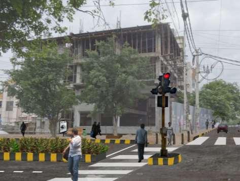
6 Reconfigured junction will reduce crossing distances from xx m to xxm Signage at entry points to the development EXISTING SITUATION Space for installation to create identity PROPOSED DESIGN Consistent road widths will prevent bottle necks in the area A B C Section A: Junction of 14 th main road and ORR


7 Reconfigured junction will reduce crossing distances from25m to 15m Signage at entry points to the development A B C Directional Maps that guide visitors through the development EXAMPLES Space for installation to create identity PROPOSED DESIGN Consistent road widths will prevent bottle necks in the area Section A: Junction of 14 th main road and ORR


8 Reconfigured junction will reduce crossing distances from25m to 15m Signage at entry points to the development A B C Street art virtualpaulscrossproject.blogspot.com Statues PROPOSED DESIGN Section A: Junction of 14 th main road and ORR Space for installation to create identity Consistent road widths will prevent bottle necks in the area

9 Table top pedestrian crossing for easy pedestrian access Parking bays integrated into sidewalks Providing facilities of Public restrooms and drinking water A B C forums.finalgear.com Section B: 14 th main road between ORR and 17 th cross Reworking of the BDA complex to build a plaza space


10 Table top pedestrian crossing for easy pedestrian access Parking bays integrated into sidewalks Providing facilities of Public restrooms and drinking water A B C Section B: 14 th main road between ORR and 17 th cross

11 Table top pedestrian crossing for easy pedestrian access Parking bays integrated into sidewalks Providing facilities of Public restrooms and drinking water A B C soni2006.hubpages.com Section B: 14 th main road between ORR and 17 th cross Reworking of the BDA complex to build a plaza space


12 A B C arcadiasbest.com Section B: 14 th main road between ORR and 17 th cross


13 Median to control turning movements AUTO STAND BUS BAY FOR 2 BUSES no blockage of traffic Cycle stand A B C Space for Bus stop and signage


14 Median to control turning movements AUTO STAND BUS BAY FOR 2 BUSES no blockage of traffic A B C


15 Location of HSR NIP Location in Bangalore Median to control turning movements AUTO STAND BUS BAY FOR 2 BUSES no blockage of traffic A B C


16 Median to control turning movements AUTO STAND BUS BAY FOR 2 BUSES no blockage of traffic A B C


17

18
19 Items Area (sqmts) Length Number Bicycle Track M NA Footpath (West) M NA Footpath (East) M NA Table top crossings NA 9 Two-wheeler parking NA 26 Car Parking NA 8 Autorickshaw Stand/Parking NA 7 Street furniture NA NA 160 Street Lights NA NA 64 Maps NA NA 3 Advertisement Boards NA NA 16 Trees NA NA 45
20 DEMONSTRATION AREA BRTS JUNCTION DESIGN Junction BRTS Agara Lake BRTS A G F E D BWSSB B


21 Junction A: CPWD junction, 21 st main road Junction B: Junction of 21 st main and 17 th cross A B


22 Junction D: Junction of 14 th main and 17 th cross Junction E: Junction of 9 th main and 17 th cross D E

23 Thank You!
CURRENT ORIGINAL REFERENCE SECTIONS. (Typical Section) (Typical Section) The Parade Island Bay : Concept Option Summary Sheets.
 (Typical Section) The Parade Island Bay : Concept Option Summary Sheets.") ORIGINAL (Typical Section) CURRENT (Typical Section) 3,900 3,000 2,000 1,500 3,100 1,600 3,100 1,500 2,000 2,500 3,900 3,000 1,800 600 2,000 3,000 3,000 2,000 600 1,800 2,500 Existing Planting Traffic
ORIGINAL (Typical Section) CURRENT (Typical Section) 3,900 3,000 2,000 1,500 3,100 1,600 3,100 1,500 2,000 2,500 3,900 3,000 1,800 600 2,000 3,000 3,000 2,000 600 1,800 2,500 Existing Planting Traffic
PUBLIC REALM MASTER PLAN
 WESTSHORE BUSINESS DISTRICT PUBLIC REALM MASTER PLAN MASTER PLAN COMMITTEE MEETING MARCH 20, 2013 WESTSHORE BUSINESS DISTRCT PUBLIC REALM MASTER PLAN MACRO-SCALE CONCEPT: A PUBLIC REALM FRAMEWORK DEFINED
Public Comment Meeting Geary BRT Project Draft Environmental Impact Statement/Report
 Public Comment Meeting Geary BRT Project Draft Environmental Impact Statement/Report Open House and Opportunity to Provide Comments Public comments can be submitted to the court reporter stationed in the
A Guide to Great Streets: The Basics. September 25, 2009
 A Guide to Great Streets: The Basics September 25, 2009 Streets are more than connectors, they are the city 2 Streets are the glue that hold a city together 3 Streets are the means in which a city is perceived
Bicycle Network Submission
 Bicycle Network Submission Complete Streets: Cycleway and Streetscapes Submission to Waverley Council 20 November 2014 Bicycle Network Submission, Complete Streets: Cycleway and Streetscapes 1 Bicycle
MCARTHUR AVENUE AS WE HEARD IT REPORT CYCLING LANES. City of Ottawa Transportation Services. Photo: istock
 MCARTHUR AVENUE CYCLING LANES Photo: istock AS WE HEARD IT REPORT City of Ottawa Transportation Services CONTENTS Background...1 Consultation Activities Summary...1 Public Commentary Questionnaire Results...2
NJDOT Complete Streets Checklist
 Background The New Jersey Department of Transportation s Complete Streets Policy promotes a comprehensive, integrated, connected multi-modal network by providing connections to bicycling and walking trip
Bicycle Facilities Planning
 Bicycle Facilities Planning Overview Types of Cyclists Purpose for Riding Types of Facilities Bike Lanes Bicycle Boulevards Cycle Tracks Intersections Signals Signing and Marking Discussion Types of Bicyclists
West Village Mobility & Integration
 West Village Mobility & Integration PRESENTED TO TOPCA Town Hall November 9, 2017 [7189-21] Port Credit 2 West Village + Mobility AWalkable Community A CompleteCommunity A SustainableCommunity 3 Mobility
42nd Ave N Reconstruction
 CITY OF MINNEAPOLIS 42nd Ave N Reconstruction Community Meeting #2 May 2016 6:00 7:30 p.m. 5/16/2016 1 Purpose of Meeting Inform: Provide an overview of project, identify anticipated scope of work, and
Healthy Built Environments Cowlitz-Wahkiakum County, Washington
 Healthy Built Environments Cowlitz-Wahkiakum County, Washington Bringing Back Active Transportation and Health Presented By Dan Burden, Blue Zones, LLC Livability/Health and the role of Place, Walkability
Community Task Force November 15, 2017
 Community Task Force November 15, 2017 Welcome and Introductions Project Partners Regional Transportation District (RTD) Colorado Department of Transportation (CDOT) Denver Regional Council of Governments
In station areas, new pedestrian links can increase network connectivity and provide direct access to stations.
 The Last Mile Planning for Pedestrians Planning around stations will put pedestrians first. Making walking to stations safe and easy is important; walking will be a part of every rapid transit Accessible
PRINCE GEORGE S PLAZA METRO AREA PEDESTRIAN PLAN
 PRINCE GEORGE S PLAZA METRO AREA PEDESTRIAN PLAN May 28, 2008 Agenda Welcome and introductions Project overview and issue identification Planning context and strengths Design challenges and initial recommendations
RIVERSIDE, Newton MA BH NORMANDY RIVERSIDE LLC. Riverside Station. A green, transit-oriented community
 Riverside Station A green, transit-oriented community October 6, 2011 TONIGHT S AGENDA: 1. Project Update (5 min.) 2. Master Plan Update (10 min.) 3.Traffic Plan Update (10 min.) Questions & Answers MASTER
GIS Based Data Collection / Network Planning On a City Scale. Healthy Communities Active Transportation Workshop, Cleveland, Ohio May 10, 2011
 The Purpose of GIS Based Network Planning GIS Based Data Collection / Network Planning Healthy Communities Active Transportation Conference Tuesday, May 10, 2011 10:00 AM Norman Cox, LLA, ASLA. Ann Arbor,
Lawrence Avenue Streetscape Concepts August 30, 2011
 Lawrence Avenue Streetscape Concepts August 30, 2011 Neighborhood Context Phase II: River to Western Ave. Phase I: Western Ave. to Clark St. Key Map Lawrence Ave. Existing Streetscape Conditions East of
THE ALAMEDA CONCEPT DESIGN COMMUNITY MEETING 3. A Plan for The Beautiful Way JANUARY 28, 2010
 CONCEPT DESIGN COMMUNITY MEETING 3 JANUARY 28, 2010 AGENDA INTRODUCTION COMMUNITY INPUT ROADWAY STUDIES STREETSCAPE DESIGN STATIONS DISCUSSION SUMMARY AND DISCUSSION NEXT STEPS CLOSE INTRODUCTION SCHEDULE
Welcome. If you have any questions or comments on the project, please contact:
 Welcome This drop-in public open house is intended to provide information about the Bay Street bike lanes project. This project proposes a dedicated cycling facility along Bay Street between Aberdeen Avenue
Business owner or commercial property owner in Arlington, 8. Visitor in Arlington, 17
 1. How do you currently travel around your neighborhood? (Select your top 3) Resident of Arlington 86.72% 222 Worker in Arlington 20.70% 53 Business owner or commercial property own 3.13% 8 Visitor in
STREETSCAPE CONCEPTS
 STREETSCAPE S CARGO WAY CARGO WAY CYCLE TRACK Streetscape Concepts JENNINGS ST Illustrative Plan EVANS AVE PG&E BAY TRAIL HERON S HEAD PARK The recommended improvements build off the planned improvements
El Camino Real Specific Plan. TAC/CAC Meeting #2 Aug 1, 2018
 El Camino Real Specific Plan TAC/CAC Meeting #2 Aug 1, 2018 Land Use Alternatives Goals and Tradeoffs Parks & open space Housing Retail & services Civic spaces Parking Community gathering spaces 3 Alternatives
Supporting Safer Cities. ENHANCING LAST MILE CONNECTIVITY a safety analysis of the Mandi House Metro Station
 Supporting Safer Cities ENHANCING LAST MILE CONNECTIVITY a safety analysis of the Mandi House Metro Station This Report has been prepared as part of the Project being undertaken with NDMC to Enhance the
CLOSED. Highlights of the Final Concept Design:
 The final Concept Design is the result of many months of listening, learning, creating, balancing, and understanding different needs and viewpoints, as well as incorporating technical requirements and
Urban Street Design and Development
 Urban Street Design and Development Ashok Bhattacharjee, Advisor, Clean Air and Sustainable Mobility, Centre for Science and Environment CSE Workshop on Safe Access and Parking - Lytton Hotel, Kolkata
Ocean Park Boulevard Green Street Project Alternatives & Trade Offs
 Planning Commission March 4, 2009 Ocean Park Boulevard Green Street Project Alternatives & Trade Offs Purpose of Tonight s Meeting Review concept plans and options Provide input on alternatives and trade-offs
Tonight is for you. Learn everything you can. Share all your ideas.
 Strathcona Neighbourhood Renewal Draft Concept Design Tonight is for you. Learn everything you can. Share all your ideas. What is Neighbourhood Renewal? Creating a design with you for your neighbourhood.
GEARY CORRIDOR BUS RAPID TRANSIT Environmental Analysis. Special Intersections: Preliminary Concepts
 GEARY CORRIDOR BUS RAPID TRANSIT Environmental Analysis Special Intersections: Preliminary Concepts April 2, 2009 FILLMORE: Existing Conditions 3 lanes in underpass, 2 lanes in service road (each direction)
Anniedale- Tynehead NCP Best Practices in Transportation Planning Summary
 Anniedale- Tynehead NCP Best Practices in Transportation Planning Summary The City of Surrey Anniedale-Tynehead NCP Best Practices Transportation Summary This document provides a summary of the Bunt &
TRANSPORTATION STANDARDS
 INTRODUCTION LOCAL STREETS ON-STREET PARKING SIDEWALKS STREET LIGHTING STREET FURNISHINGS TRAFFIC CALMING STREET TREES MEDIAN PLANTING BOULEVARD LOCATIONS VILLAGE CENTER STREET LOCATIONS RESIDENTIAL STREET
Getting Your SRTS Project Funded. Ryan Snyder
 Getting Your SRTS Project Funded Ryan Snyder Steps in Submitting a Successful Application 1. Stakeholder outreach: create a SRTS coalition 2. Develop a comprehensive plan and program with all 5 Es 3. Conceive
IMPLEMENTATION. PEDESTRIAN USERS (Continued /) A: Class 2 Pedestrian / Cycle Ways. Pedestrian and Cycle Ways:
 A: Class 2 Pedestrian / Cycle Ways. Pedestrian and Cycle Ways:") A: Class 2 Pedestrian / Cycle Ways PLAN VIEW Pedestrian and Cycle Ways: Layout and Geometry (Refer to A): Walkways and cycle to be provided adjacent to all Class 2 Roads (these facilities should always
A: Class 2 Pedestrian / Cycle Ways PLAN VIEW Pedestrian and Cycle Ways: Layout and Geometry (Refer to A): Walkways and cycle to be provided adjacent to all Class 2 Roads (these facilities should always
Table #6 VISION CHARACTERISTICS
 Table #6 VISION White Flint is a place to live, work, play, shop, and walk with sufficient density to encourage quality redevelopment. Vibrant streets and consistent streetscapes are important. CHARACTERISTICS
Bicycle and Pedestrian Advisory Committee (BPAC) November 21, 2013
 November 21, 2013") Bicycle and Pedestrian Advisory Committee (BPAC) November 21, 2013 OVERALL LAND USE CONCEPT Overall Broadway Valdez District: 95.5 acres (35.1 acres right-of ways + 60.4 acres developable land) Plan Subareas:
Bicycle and Pedestrian Advisory Committee (BPAC) November 21, 2013 OVERALL LAND USE CONCEPT Overall Broadway Valdez District: 95.5 acres (35.1 acres right-of ways + 60.4 acres developable land) Plan Subareas:
2018 Transportation Alternatives Program (TAP) Application Presentation to Palm Beach TPA BRANT BRIDGE CONNECTION LOOP EXTENSION ON CARL BOLTER DR
 Application Presentation to Palm Beach TPA BRANT BRIDGE CONNECTION LOOP EXTENSION ON CARL BOLTER DR") 2018 Transportation Alternatives Program (TAP) Application Presentation to Palm Beach TPA BRANT BRIDGE CONNECTION LOOP EXTENSION ON CARL BOLTER DR Project Location N N Connecting South Delray Beach Existing
2018 Transportation Alternatives Program (TAP) Application Presentation to Palm Beach TPA BRANT BRIDGE CONNECTION LOOP EXTENSION ON CARL BOLTER DR Project Location N N Connecting South Delray Beach Existing
GLYNN COUNTY MANAGER S OFFICE 1725 Reynolds Street, Third Floor, Brunswick, GA Phone: (912) Fax: (912)
 Fax: (912)") GLYNN COUNTY MANAGER S OFFICE 1725 Reynolds Street, Third Floor, Brunswick, GA 31520 Phone: (912) 554-7401 Fax: (912) 554-7596 www.glynncounty.org MEMO TO: FROM: The Honorable Commissioners Alan Ours,
GLYNN COUNTY MANAGER S OFFICE 1725 Reynolds Street, Third Floor, Brunswick, GA 31520 Phone: (912) 554-7401 Fax: (912) 554-7596 www.glynncounty.org MEMO TO: FROM: The Honorable Commissioners Alan Ours,
Arlington s Master Transportation Plan
 Arlington s Master Transportation Plan The Master Transportation Plan (MTP) Adopted in eight parts Goals & Policies element and MTP Map adopted in 2007 Bicycle, Pedestrian and Demand and Systems Management
Equitable Road Space : Case study Vikas Marg, New Delhi
 Equitable Road Space : Case study Vikas Marg, New Delhi Laxmi Nagar Chungi to Karkari Mor PWD, Govt. of NCT of Delhi Methodology Adopted STAGE 1 : Understand Equitable Road Space and Design STAGE 2 : Study
Sarasota High School June 26, 2018
 June 6, 08 June 9, 08 Review of SHS Security & Safety, Community Input & Ideas June 6, 08 Review of Community Concerns and Ideas, Confirm Community Enhancement Priorities July/August, 08 Vacation Application
CITY OF OTTAWA ROADWAY MODIFICATION APPROVAL UNDER DELEGATED AUTHORITY
 RMA-2015-ATM-038 CITY OF OTTAWA ROADWAY MODIFICATION APPROVAL UNDER DELEGATED AUTHORITY DATE: April 22, 2015 SUBJECT Approval of Roadway Modifications Recommended through an Area Traffic Management Study
Supporting Safer Cities. ENHANCING LAST MILE CONNECTIVITY a safety analysis of the RK Ashram Marg Metro Station
 Supporting Safer Cities ENHANCING LAST MILE CONNECTIVITY a safety analysis of the RK Ashram Marg Metro Station This Report has been prepared as part of the Project being undertaken with NDMC to Enhance
Pavement Rehabilitation & Buffered Bike Lane
 Pembina Highway from Grant Avenue to Osborne Street Pavement Rehabilitation & Buffered Bike Lane Welcome April 21, 2016 Please complete and submit a comment sheet prior to leaving or complete it online
Better Market Street Project. Project Update January 15, 2015
 Better Market Street Project Project Update January 15, 2015 Better Market Street Project Area Limits Market Street 2.2 Miles Mission Street Better Market Street Schedule Market Street City s busiest transit
DMURS - Practical Implications
 Comhairle Contae Fhine Gall DMURS - Practical Implications Sean McGrath. 13 November 2013 Planning and Strategic Infrastructure Department DMURS Practical Implications What DMURS means for: Street Layouts
GLEN EIRA CITY COUNCIL. MURRUMBEENA Transforming our neighbourhood together our concepts based on your ideas
 GLEN EIRA CITY COUNCIL MURRUMBEENA Transforming our neighbourhood together our concepts based on your ideas 1 WHAT HAVE WE HEARD? WHAT NOW? Stage one Tell us what you love about your shopping strip November
Morristown, NJ Complete Streets Policy
 Morristown, NJ Complete Streets Policy Introduction A Complete Street is defined as a means to provide safe access for all users by designing and operating a comprehensive, integrated, connected multi-modal
Figure 4-10: Pedestrian Improvements Types of Potential Station Area Improvements - Place-Making Improvements
 INCORPORATE FEATURE PAVIN IN CROSSWALK AND INTERSECTION FIELDS Identifies high-priority pedestrian areas and create a station identity through colorful and interesting patterns ADD CURB EXTENSIONS Extending
Microscale Audit of Pedestrian Streetscapes (MAPS), Mini Version
, Mini Version") Microscale Audit of Pedestrian Streetscapes (MAPS), Mini Version Training Manual & Picture Guide Developed by: Carrie Geremia Kelli Cain Revised February 11, 2014 Tool and protocol developed by: James
Microscale Audit of Pedestrian Streetscapes (MAPS), Mini Version Training Manual & Picture Guide Developed by: Carrie Geremia Kelli Cain Revised February 11, 2014 Tool and protocol developed by: James
Technical Working Group November 15, 2017
 Technical Working Group November 15, 2017 Welcome and Introductions Project Partners Regional Transportation District (RTD) Colorado Department of Transportation (CDOT) Denver Regional Council of Governments
A CHANGING CITY. of Edmonton, it is essential that it reflects the long-term vision of the City.
 A CHANGING CITY By the year 2040, Edmonton will be home to more than 1 million people. To accommodate growth and support a healthy and compact city, we need a new approach to development/redevelopment
Chapter 5. Complete Streets and Walkable Communities.
 Chapter 5. Complete Streets and Walkable Communities. 5.1 Description of Complete Streets. Cities throughout the world, and specifically the United States, are coming to embrace a new transportation and
Community Bicycle Planning
 Community Bicycle Planning City of Mentor s Bicycle Facility Plan Allen E. Pennington, P.E. Civil Engineer - Traffic Office of the Mentor City Engineer Why has Mentor participated in bicycle planning?
IMPLEMENTATION. PEDESTRIAN USERS (Continued /) Building Frontages: A: Stair Applications. Geometry (Accessed from the Sidewalk) Refer to A:
 Building Frontages: A: Stair Applications. Geometry (Accessed from the Sidewalk) Refer to A:") A: Stair Applications Building Frontages: Geometry (Accessed from the Sidewalk) Refer to A: Ramps should be provided for disabled users at 1:12 (8.3%) gradient. Ramp rises should be stepped at 400mm intervals.
A: Stair Applications Building Frontages: Geometry (Accessed from the Sidewalk) Refer to A: Ramps should be provided for disabled users at 1:12 (8.3%) gradient. Ramp rises should be stepped at 400mm intervals.
Bikeway action plan. Bicycle Friendly Community Workshop March 5, 2007 Rochester, MN
 Bikeway action plan Summary The was held on March 5, 2007 at the Rochester Mayo Civic Center. The workshop was hosted by Rochester-Olmsted County Planning Department in collaboration with the League of
Brooklyn Boulevard (County Road 152) Reconstruction Project Phase I. OPEN HOUSE June 20, 2017
 Reconstruction Project Phase I. OPEN HOUSE June 20, 2017") Brooklyn Boulevard (County Road 152) Reconstruction Project Phase I OPEN HOUSE June 20, 2017 Brooklyn Boulevard (County Road 152) Phase I Project Partners Project Lead Other Project Partners include Brooklyn
Brooklyn Boulevard (County Road 152) Reconstruction Project Phase I OPEN HOUSE June 20, 2017 Brooklyn Boulevard (County Road 152) Phase I Project Partners Project Lead Other Project Partners include Brooklyn
Major Bike Routes 102 Avenue Workshop April 21, 2015
 Major Bike Routes 102 Avenue Workshop April 21, 2015 Our Purpose Today Provide context on how Major Bike Routes fit into Edmonton s future Share information on what we heard in our last phase, and how
Memorandum CITY OF DALLAS. Continental Bridge & West Dallas Gateway. January5, 2012
 Memorandum DATE January5, 2012 CITY OF DALLAS TO Trinity River Corridor Project Committee Members: Vonciel Jones Hill (Chair) Linda Koop (Vice Chair), Monica Alonzo, Scott Griggs, Angela Hunt, and Delia
MARTIN LUTHER KING JR. WAY
 OCTOBER 2011 40 Vision and Goals The Martin Luther King, Jr. Way Illustrative Master Plan that follows has been developed through a process of community involvement. It expresses a long term vision for
Item to be Addressed Checklist Consideration YES NO N/A Required Description Complete Streets Guidelines
 Passaic County Complete Streets Checklist - Concept Development Project Name Item to be Addressed Checklist Consideration YES NO N/A Required Description Complete Streets Guidelines Existing Plans Have
Broad Street Bicycle Boulevard Design Guidelines
 Broad Street Bicycle Boulevard Design Guidelines Building from the strategies introduced in the 2013 Bicycle Transportation Plan and community input received thus far, City Transportation Staff have identified
McLean Main Street Public Forum Follow-up
 McLean Main Street Public Forum Follow-up Sponsored & Hosted by John W. Foust, Dranesville District Supervisor McLean Planning Committee Fairfax County Office of Community Revitalization and Reinvestment
About the study. North Milwaukee Ave. Key goals of this study are to: Achieve Vision Zero* by. Harmonize the space and improve walkability
 About the study Key goals of this study are to: North Milwaukee Avenue is a local and regional street for multiple modes of transportation. It is officially zoned and functions as a pedestrian street southeast
5 CIRCULATION AND STREET DESIGN
 5 CIRCULATION AND STREET DESIGN This chapter describes circulation and streetscape improvements proposed for the Northwest Chico Specific Plan Area. It includes detailed design specifications for existing
MAG Town of Cave Creek Bike Study Task 6 Executive Summary and Regional Significance Report
 Page 1 MAG Town of Cave Creek Bike Study Task 6 Executive Summary and Regional Significance Report August 1, 2012 MAG Project #481 Page 2 Task 6 Executive Summary and Regional Significance Report Introduction
Chapter 3: Multi-Modal Circulation and Streetscapes
 CHAPTER 3: MULTI-MODAL CIRCULATION AND STREETSCAPES Chapter 3: Multi-Modal Circulation and Streetscapes Overview Streetscape improvements have already been completed for Depot Street between Main Avenue
Board-Approved Funding Awards for Cycle 4 Active Transportation Grant Program Projects (in Order of Project Rankings) Approved on
 Approved on") CAPITAL Large Category Projects Board-Approved Funding Awards for Cycle 4 Active Transportation Grant Program Projects (in Order of Project Rankings) Approved on 07-27-18 1 La Mesa University Ave Pedestrian
CAPITAL Large Category Projects Board-Approved Funding Awards for Cycle 4 Active Transportation Grant Program Projects (in Order of Project Rankings) Approved on 07-27-18 1 La Mesa University Ave Pedestrian
Street Design Guidelines for Greater Mumbai
 Street Design Guidelines for Greater Mumbai January 2014 STREET DESIGN GUIDELINES FOR GREATER MUMBAI Introduction While 51% of all trips in Mumbai are by walking 1, yet pedestrians are the most vulnerable
Marina Bay Trail Community Meeting #1
 Marina Bay Trail Community Meeting #1 AGENDA 1. Introductions: Meghan Tiernan, DPW Cristina Olea, DPW Jerry Robbins, SFMTA 2. Meeting Purpose:. 4. 5. 6. To introduce the project to the community and gather
Eliminate on-street parking where it will allow for a dedicated bus only lane %
 Traffic Dashboard Priorities Survey Responses Introduction 1) Are you familiar with bus rapid transit (BRT)? a. No, BRT is new to me. 597 23.5% b. I ve heard of BRT, but I don t know much about it. 1,136
Niantic Center Elementary School
 Niantic Elementary School is located in the Northwest corner of the intersection of West Main Street and East Pattagansett Road, as so noted on the Facility Location Map. location Overview: The site is
STONY PLAIN ROAD STREETSCAPE
 Jasper Place Revitalization Strategy: Vision The people involved in the Jasper Place Revitalization Strategy envision: Goal 1: Feeling safe in our community Create a community where feeling safe is common--where
North End Traffic Management Study
 Public Meeting and Open House June 26, 2007 Presentation of Preferred Plan Meeting Purpose Re-iterate nature of existing problems, future opportunities and a Vision for the North End transportation system
STREETS ENTRY ROADS E1 E2 RING ROAD R1 R2 R3 R4 R5 R6 R7 CIVIC STREETS C2 C3 B-DOUBLE ROADS B1 LOCAL STREETS LANEWAY LA1 ISSUE
 STREETS ETRY ROADS E1 E2 RIG ROAD R1 R2 R3 L3 L1 R4 R5 R6 R7 CIVIC STREETS R7 C1 R6 C4 L2 C2 C3 E1 LA1 LA1 R1 E2 C4 B-DOUBLE ROADS B1 L2 LA1 R5 C3 C1 C2 R2 B1 LOCAL STREETS L1 L2 L3 LAEWAY LA1 R3 R4 31
Complete Streets Chicago: Data Driven Design. Luann Hamilton Deputy Commissioner
 Complete Streets Chicago: Data Driven Design Luann Hamilton Deputy Commissioner AGENDA Chicago s goals Complete Streets & Sustainable Infrastructure Guides Data-Driven Planning Setting goals Scoping/research
TEAM: ROAD: SECTION: K K Nagar Walkability Survey 19 th June 2013
 K K Nagar Walkability Survey 19 th June 2013 TEAM: ROAD: SECTION: Length of surveyor s foot in cms. (any one): (this surveyor will measure distances required in Table II and points 2.c and 4.a in Table
Agenda. Overview PRINCE GEORGE S PLAZA METRO AREA PEDESTRIAN PLAN
 PRINCE GEORGE S PLAZA METRO AREA PEDESTRIAN PLAN May 28, 2008 Agenda Welcome and introductions Project overview and issue identification Planning context and strengths Design challenges and initial recommendations
School Travel Survey for Principals. 1. How do most of your students get to school in the morning? (Please select only one box)
") School Travel Survey for Principals 1. How do most of your students get to school in the morning? (Please select only one box) by school bus by public transportation (e.g., city bus) by other motor vehicle
School Travel Survey for Principals 1. How do most of your students get to school in the morning? (Please select only one box) by school bus by public transportation (e.g., city bus) by other motor vehicle
Arlington Public Schools Thomas Jefferson Site Evaluation Transportation Networks. Thomas Jefferson Working Group Meeting #6 November 10, 2014
 Arlington Public Schools Thomas Jefferson Site Evaluation Transportation Networks Thomas Jefferson Working Group Meeting #6 November 10, 2014 2 3 INTRODUCTION 4 Goal of our work: Identify and assess multi-modal
Public Feedback Comments Appendix G. Appendix G. Public Feedback Comments. Virginia Beach Bikeways and Trails Plan 2011 Page G-1
 Public Feedback Comments Virginia Beach Bikeways and Trails Plan 2011 Page G-1 This is a complete collection to date of responses to the feedback survey which was used at public open houses in December
Roosevelt Estates Neighborhood Improvements
 Roosevelt Estates Neighborhood Improvements Transportation Alternatives Application May 5 th, 2016 Qualifying Activities Construction of on-road and off-road trail facilities for pedestrians, bicyclists,
Point Defiance Park. Master Plan
 Point Defiance Park Master Plan Public Participation 1/29, 2/26, 3/26 & 4/23 Owen Beach Ferry Zoo Fort Nisqually Mildred Street Pearl Street Triangle Hare & Hare Master Plan - 1911 2008 Concept Plan Comments
Saskatchewan Drive Roadway Rehabilitation and Shared-Use Path Widening
 Saskatchewan Drive Roadway Rehabilitation and Shared-Use Path Widening We are here today to present the draft plan for the Saskatchewan Drive Roadway Rehabilitation and Shared-Use Path Widening project
El Centro Mobility Hub
 The El Centro drive shed comprises a major portion of the El Centro downtown area, which is well served by bus routes. The proposals intend to promote use of public transit through improvements and enhancements
Replacement of N. Carlin Springs Road Bridge over George Mason Dr.
 Replacement of N. Carlin Springs Road Bridge over George Mason Dr. Approximate schedule with phases and proposed Maintenance of Travel (MOT) plans February 2017 Project Elements Removal of existing bridge
DRAFT - CITY OF MEDFORD TRANSPORTATION SYSTEM PLAN Roadway Cross-Sections
 Roadway Cross-Sections Medford s roadway cross-section standards apply to new and reconstructed roads. The crosssections take into consideration roadway function and operational characteristics, including
South Terrace Pedestrian Safety and Streetscape Improvement: Community Engagement Summary
 SUMMARY This report provides a summary of the results of the City of Fremantle s community engagement on the proposed traffic and streetscape improvements to South Terrace, between Sydney Street and Little
1.3 Pedestrian Environments
 SECTION 1: COMMERCIAL DEVELOPMENT 1.3 Pedestrian Environments Design Principle The quality of the pedestrian environment often defines the overall success of a commercial project. Attention to the development
Implementing the Three Es of School Zone Traffic Calming
 Implementing the Three Es of School Zone Traffic Calming Use this evaluation tool as a guide to analyze the specific safety needs of your school. SCHOOL PROFILE School Name: School District: Address: Phone
6.4 RECOMMENDED IMPROVEMENTS
 6.4 RECOMMENDED IMPROVEMENTS 6.4.1 Williston Road Recommendations While all alternatives would be an improvement over existing conditions, Alternative 3B is recommended over the others because it provides
CLOSED. The draft concept design has been broken down into 5 categories for the purpose of this survey:
 Old Strathcona s neighbourhood renewal process is now at the draft concept design phase. Over the last several months, the city has been gathering local knowledge and resident input that has been used
Appendix C 3. Bicycle / Pedestrian Planning
 Appendix C 3. Bicycle / Pedestrian Planning BICYCLE/PEDESTRIAN PLANNING 2005 Master Plan GOAL: Provide for safe and convenient bicycle and pedestrian circulation throughout the City. Develop a city-wide
Make Lincoln Highway an economically vibrant corridor that is safe, efficient, and beautiful for local residents and visitors.
 Lincoln Highway Streetscape Plan Stakeholder Workshop #2 Handout Contents Introduction and Project Vision Planning Principles Specific Recommendations including a Proposed Typical Roadway Section Renderings
Centennial Neighbourhoods Transportation Management Plan Summary of Phase 1 Consultation. Overview of Issues
 1 Centennial Neighbourhoods Transportation Management Plan Summary of Phase 1 Consultation The Centennial Neighbourhoods Transportation Management Plan (CNTMP) is being undertaken to support the Secondary
ABOUT THE PROJECT. DOWNTOWN WEST Transportation Planning Study. Pennsylvania Ave. NW: H Street NW: Farragut. K St. NW. North. I St.
 ABOUT THE PROJECT Downtown West seeks to improve east-west travel for pedestrians and cyclists on Pennsylvania Avenue NW and persons using public transit along H and I Streets NW. K St. NW North I St.
3.2 TRANSPORTATION NETWORKS
 3.2 TRASORTATIO ETWORKS EDESTRIA ETWORK The Islands various blocks, neighborhoods, parks, and other public spaces are connected by a diverse network of pedestrian routes. Its core consists of primary routes
School Travel Survey for District Superintendents/Board Chairs
 School Travel Survey for District Superintendents/Board Chairs 1. How do most of the elementary and middle school students in your district get to school in the morning? (Please select only one box) by
9 Leeming Drive Redevelopment Ottawa, ON Transportation Brief. Prepared By: Stantec Consulting Ltd.
 9 Leeming Drive Redevelopment Ottawa, ON Transportation Brief Prepared By: Stantec Consulting Ltd. TIA GUIDELINES CHECKLIST Report Context Municipal Address Comment: Section 1.1 Location relative to major
Ocean Park Boulevard Streetscape Improvement Project Alternatives & Trade Offs
 City Council Study Session January 27, 2009 Ocean Park Boulevard Streetscape Improvement Project Alternatives & Trade Offs Scope of Work Purpose of Tonight s Meeting Review work to date and direct staff
All Season Age Friendly Pedestrian Safety and Walkability Checklist *
 FOSTERING AGE FRIENDLY, WALKABLE NEIGHBOURHOODS Walkability is a key component of optimal aging in Age Friendly cities. Walkable neighbourhoods promote physical and mental health and well-being, support
APPENDIX A: Complete Streets Checklist DRAFT NOVEMBER 2016
 APPENDIX A: Complete Streets Checklist DRAFT NOVEMBER 2016 Complete Streets Checklist MetroPlan Orlando s Complete Streets Checklist is an internal planning tool for staff to further implementation of