Chicago Department of Transportation Bikeways - Year in Review
|
|
|
- Jewel Chapman
- 6 years ago
- Views:
Transcription


1 Chicago Department of Transportation Year in Review

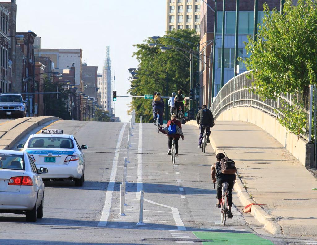
2 -protected bike lane on Division Street east of Damen Avenue


3 Table of Contents 2015 Achievements 01 Barrier- Bike Lanes Bike Lanes Improvements 17 Restriping 19 List of All 2015 Projects 21 Cover Image: Washington Street Barrier- Bike Lane and Intersection Washington Street barrier-protected bike lane at LaSalle Street

4 2015 Achievements In 2015, CDOT installed 42 miles of new and restriped bikeways, including 23 miles of barrier and buffer-protected bike lanes. Since May of 2011, over 108 miles of protected bike lanes have been installed throughout Chicago. Achievements in 2015 include: Surpassed Mayor Emanuel s goal of installing 100 miles of protected bike lanes Installed five curb separated bike lanes and one raised bike lane Two projects ranked in People For Bikes Top Ten List of the country s best protected bike lanes Expansion of the downtown protected bike lane network Installed bike lanes in 31 wards Implemented Chicago s first green wave Bike improvements made to 3 bridges Resurfaced 26 miles of the bikeways network, including 10 miles of new bikeways and 16 miles of restriped bikeways Awarded the 2015 Sustainable Landscape Award by the Metropolitan Water Reclamation District for the Berteau Neighborhood Greenway 1 Milwaukee Avenue north of Elston Avenue with new barrier-protected bike lane
5 Chicago s On-Street 2015 Project Locations *Complete listing of 2015 projects available at end of report Barrier- Bike Lanes - Bike Lanes Neighborhood Greenways 1.5 Miles Miles 87.0 Miles Bikeway Type 2015 Installations Barrier- Bike Lanes - Bike Lane Restriped Existing Bikeway Network Miles Marked Shared Lanes 45.7 Miles Bike Lanes 88.5 Miles Total On-Street : Miles New and Restriped Miles Barrier- Bike Lanes Restriped 3.35 mi. 8% mi. 39% 42.2 MILES OF NEW AND RESTRIPED BIKEWAYS IN mi. 47% - Bike Lanes 2.6 mi. 6% 2
6 Barrier Restriping Improvements 1 Barrier- Bike Lanes Chicago continues to expand its protected bike lane network throughout the city. In 2015, 2.85 miles of new barrier-protected bike lanes were installed and 0.5 miles of existing barrier-protected bike lanes were upgraded with concrete separation. People for Bikes, a national advocacy organization, ranked projects on Clybourn Avenue and Clinton Street as two of the country s best bike lanes of the year, and also noted Chicago s connected network of protected bike lanes as the best in the country. Barrier-protected bike lanes installed and upgraded in 2015 include: Milwaukee Avenue - New barrier protected bike lanes between Elston Avenue and Augusta Boulevard help make the City s busiest street for bicycling more comfortable for all Chicagoans. The Milwaukee project includes concrete curb separation, green pavement markings, and a bike passing lane over I-90/94. Underutilized street parking was converted to curb-side bike lanes, creating a 5-mile route of better bike lanes connecting River West, the West Loop, and downtown. 31st Street - Concrete curb separation and roadway resurfacing on 31st Street between LaSalle Street and Michigan Avenue were part of an upgrade to the protected bike lane connecting residents and students to the Illinois Institute of Technology (IIT), the Lakefront Trail, and the 31st Street Harbor. This project exemplifies the strategy of installing bike infrastructure quickly, then upgrading the project through future improvements. Sacramento Boulevard - Chicago s first curb separated bike lane was installed on Sacramento Boulevard between Ogden Avenue and Douglas Boulevard. Like 31st Street, Sacramento initially utilized bollards to separate people riding their bikes from people driving when it was installed in The curb separation was added in conjunction with a resurfacing project in the summer of Bikeway Type 2015 Installations Barrier- Bike Lanes Existing Bikeway Network Miles


7 Featured Project: Clybourn Avenue Barrier- Bike Lane Barrier CDOT assisted the Illinois Department of Transportation (IDOT) with the planning, design, and construction of the Clybourn Avenue barrier-protected bike lane, the first barrier-protected bike lane installed on an IDOT jurisdiction roadway. The Clybourn Avenue barrier-protected bike lane includes curb separation and connects people riding bikes to the CTA Red Line, multiple Divvy stations, and the dense neighborhoods of Lincoln Park and Old Town. It is part of a growing bike network that provides access to downtown via barrier and buffer-protected bike lanes. Before Features First barrier-protected bike lane on an IDOT jurisdiction roadway After Concrete curbs separating people riding bikes and people driving cars Improved pedestrian crossings and pedestrian refuge islands Bicycle traffic signals at two locations (2016 installation) Landscaping incorporated into the median on Division Street Ranked #5 Best New Bike Lane of 2015 by People for Bikes Improvements Restriping 4

8 Barrier Clybourn Avenue Curb Separated Bike Lane From Division Street to Halsted Street Improvements Restriping 5


9 31st Street Curb Separated Bike Lane From LaSalle Street to Michigan Avenue Sacramento Boulevard Curb Separated Bike Lane From Ogden Avenue to Douglas Boulevard Barrier Roosevelt Road Raised Two-Way Bike Lane Near Wabash Avenue Milwaukee Avenue Curb Separated Bike Lane From Elston Avenue to Kennedy Expressway Improvements Restriping 6

10 XPY WABASH AVE MICHIGAN AVE KENNEDY EXPY GREEN ST HALSTED ST WELLS ST LASALLE ST CLARK ST DEARBORN ST STATE ST Barrier 2 As part of the Bus Rapid Transit project, CDOT is installing a network of barrier-protected bike lanes that is making it convenient, safe, and enjoyable to ride a bike around Chicago s downtown. Several features of the Loop Link bikeways are new to Chicago and help create one of the country s best downtown networks of bicycle lanes designed for people of all ages and abilities. Chicagoans and visitors can enjoy the excitement of The Loop on a bicycle thanks to the barrier-protected bike lanes, bicycle traffic signals, green pavement markings, and intersection improvements that highlight this transformation of several downtown streets. KINZIE ST GRAND AVE ILLINOIS ST ORLEANS ST HUBBARD ST LOOP NETWORK Projects Barrier- Bike Lane 2016 Barrier- Bike Lane 1 of 4 U.S. cities with a protected intersection 1st concrete separated bike lane in downtown Chicago 2nd two-way barrier-protected bike lane in downtown Chicago 9 intersections with bicycle traffic signals in 2015 COLUMBUS DR on Washington Street at LaSalle Street FULTON ST CLINOTN ST LAKE ST RANDOLPH ST WACKER DR EXISTING BIKEWAYS Barrier- Bike Lane - Bike Lane Bike Lane Marked Shared Lane Off-Street Trail WASHINGTON ST MADISON ST Improvements MONROE ST ADAMS ST JACKSON BLVD VAN BUREN ST DESPLAINES ST JEFFERSON ST CANAL ST PLYMOUTH CT CONGRESS PKWY Restriping 7 HARRISON ST POLK ST BALBO AVE 8TH ST


11 : Design Features The bikeways feature design elements that create a comfortable and enjoyable experience for people riding bikes of all age and abilities and improve transportation options throughout downtown Chicago. Curb and bus stations separating people riding bikes from people driving on Washington Street Two-way barrier-protected bike lane on Clinton Street Bicycle traffic signals at nine intersections intersection at Washington Street and Franklin Street Newly resurfaced roadway Raised bike lanes where pedestrians cross to access bus platforms Intersection markings providing guidance through intersections Green bike lane along entire corridor for increased visibility Bicycle Traffic Signals at Washington Street and Clark Street Barrier Pedestrian Refuge Island at Dearborn Street and Washington Street Intersection at Washington Street and Franklin Street Improvements Restriping 8


12 Barrier : Washington Street The Washington Street barrier-protected bike lane provides a direct connection between Ogilvie Transportation Center and Millennium Park. People riding bikes in the green bike lane located next to the sidewalk are separated from motor vehicles by bus stations. The intersection of Washington and Franklin features one of the first protected intersection designs in the country. Crossings for bicyclists and pedestrians have been shortened and motorists have dedicated turn lanes and arrows for safer turns. Bike traffic signals and pedestrian refuge islands make it easier for people walking and biking to travel through one of the country s busiest and most vibrant downtowns. Barrier- Bike Lane on Washington Street at Clark Street Barrier- Bike Lane on Washington Street west of Franklin Street Intersection at Washington Street and Franklin Street Improvements Restriping 9


13 : Clinton Street Barrier Chicago s second two-way barrier-protected bike lane was installed on Clinton Street between Jackson Boulevard and Fulton Street. The Clinton Street protected bike lanes are part of a rapidly expanding protected bike lane network and provide a low-stress connection to Union Station, the third busiest rail station in the country, Ogilvie Transportation Center, and multiple Divvy and CTA stations. People for Bikes ranked Clinton Street in their list of America s 10 Best New Bike Lanes of Bicycle traffic signals and separation from people driving make Clinton a great street for people bicycling and walking to office buildings, retail shops, and residential units in Chicago s bustling West Loop. Before Two-Way Barrier- Bike Lane on Clinton Street at Madison Street After Improvements Restriping 10
14 Barrier Restriping Improvements 3 A goal of the Streets for Cycling Plan 2020 is to ensure every resident lives within 1/2 mile of the bikeway network so that bicycling is a viable transportation option for all Chicagoans. The proposed network consists of three different routes types: Neighborhood Bike that utilize residential streets, Crosstown Bike that connect people across the city, and that connect all corners of Chicago to Downtown. In 2015, CDOT improved network connections on three. South Chicago Avenue Between 2012 and 2015, several improvements to South Chicago Avenue between Baltimore Avenue and 67th Street have made the street more bicycle and pedestrian friendly. Vincennes Avenue In 2015, buffer-protected bike lanes and pedestrian refuge islands were installed between 84th and 76th in conjunction with a roadway resurfacing project. Milwaukee Avenue Since 2013, CDOT upgraded Milwaukee Avenue from Kinzie Street to Division Street with a combination of barrier and bufferprotected bike lanes. In 2015, CDOT installed barrier and buffer-protected bike lanes between Elston and Division. The project includes curb and parking separated bike lanes, a bike passing lane, and an extension of the bike lanes up to intersections. 11 Lake Street Milwaukee Avenue Archer Avenue Clark Street Vincennes Avenue State Street Bikeway Type Streets for Cycling 2020 Existing Bikeway on Route Existing Bikeway Network SFC 2020 Route Miles South Chicago Avenue


15 Featured Route Project: South Chicago Avenue Barrier In 2015, CDOT extended the South Chicago Avenue buffer-protected bike lanes 2.25 miles north from 79th Street to 67th Street. This project included a striped buffer next to parking and motor vehicle lanes, a center left turn lane as part of a road diet, and connections to the Divvy network and the Gary Comer Youth Center and College Prep. Before New Divvy Station Location at 71st Street and South Chicago Avenue After Improvements Restriping 12
16 Barrier Improvements 4 - Bike Lanes -protected bike lanes have a buffer between the motor vehicle lane, the parking lane, or both. CDOT installed 20 miles of buffer-protected bike lanes in These projects include: 83rd Street - In conjunction with a roadway resurfacing project, the 83rd street bike lane between Vincennes Avenue and Lafayette Avenue was upgraded to a buffer-protected bike lane. Jackson Boulevard A buffer-protected bike lane was installed between Central Park Avenue and Western Avenue. The 1.5-mile project filled a gap in the bikeway network on Chicago s West Side. Jackson now has close to 4.0 miles of buffer and barrier-protected bike lanes connecting Garfield Park, Malcom X College, and the Greektown neighborhood. Elston Avenue In 2015, CDOT upgraded 4.5 miles of traditional bike lanes to buffer-protected bike lanes. Since 2012, nearly the entire 9.5 miles of Elston Avenue has been striped with buffer and barrierprotected bike lanes. Damen Avenue - -protected bike lanes, roadway resurfacing, and upgraded lighting between 18th Street and 14th Street have improved conditions for people riding their bike under the Damen Viaduct. Bikeway Type 2015 Installations - Bike Lane Existing Bikeway Network Miles Restriping 13


17 Barrier California Avenue Division Street to North Avenue Vincennes Avenue 76th Street to 84th Street - Bike Lane and Center Left Turn Lane Milwaukee Avenue Augusta Boulevard to Division Street Pedestrian Refuge Island Improvements Restriping 14

18 Barrier 5 Bikeway Type In 2015, CDOT installed 2.6 miles of new bike lanes, marked shared lanes, and a green wave: Lincoln Avenue Lincoln Avenue from Wells Street to Armitage Avenue was striped with a new marked shared lane design that incorporates a striped buffer to separate people riding their bikes and parked vehicles. This striped buffer encourages people to ride outside of the door zone. Wells Green Wave - Traffic signals on Wells Street between Wacker Drive and Huron Street were coordinated for a speed of 12 mph to allow continuous flow for people riding bikes Installations Existing Bikeway Network Miles Lincoln Avenue From Wells Street to Armitage Avenue Improvements Restriping 15


19 Featured Project: Wells Street Green Wave In the summer of 2015, Chicago s first green wave was installed on Wells Street from Wacker Drive to Huron Street. A green wave coordinates traffic signals at a preset speed to allow continuous flow for people riding bikes. The Wells Street buffer-protected bike lane is an important connection to downtown with several closely spaced signalized intersections. The Wells Street Green Wave traffic signal progression is set for 12 mph and is based on everyday biking speeds. A majority of people riding their bike will arrive at green lights throughout the corridor. Project Benefits People riding bikes and people driving can travel through the corridor with minimal stops Increased red light compliance expected for all users Improved travel times for people riding bicycles and for people driving Project Features Traffic signals timed for desirable bicycle travel speeds (12mph) & motor vehicle speeds (30mph) New signage for bicyclists displaying signal timing speeds Barrier Green Wave on Wells Street at Grand Avenue Improvements Restriping 16
20 Barrier 6 Improvements Bicycle Friendly s In 2015, CDOT continued to place an emphasis on improving bridges to make them more bicycle friendly. Three bridges received either non-skid fiberglass plates or concrete infill in the bike lane to provide a smoother and more comfortable surface for riding. Cortland Ave. Improvements 2015 Improvements Improvements Miles The Halsted Street over the South Branch of the Chicago River received non-skid bridge plates that make riding a bicycle over the metal grate bridge safer and more comfortable. The 18th Street over the South Branch of the Chicago River received new roadway pavement, lights, sidewalk decks, and a concrete bike lane. Improvements The Cortland Street over the North Branch of the Chicago River, a popular east-west link in the bicycle network, was rehabilitated and now includes concrete infill in the bike lane. Since Mayor Emanuel took office in May of 2011, 14 Chicago bridges have been made more bicycle-friendly. Halsted St. 18th St. Restriping 17


21 Barrier 18th Street Improvements Concrete Bike Lane Cortland Street Improvements Concrete Bike Lane Halsted Street Improvements Fiberglass Plates Improvements Restriping 18

22 Barrier 7 Bikeway Restriping Bikeway Type Maintaining the existing bikeway network is as important to CDOT as expanding the network. CDOT refreshes bicycle markings whenever possible, and ensures other City departments and outside entities properly replace bicycle markings when doing work in the roadway. In 2015, CDOT restriped miles of the existing bikeway network and upgraded 0.5 mile of barrier-protected bike lanes with concrete curbs Installations Restriped Existing Bikeway Network Miles Franklin Street Monroe Street to Lake Street Improvements Restriping 19


23 Barrier Berteau Avenue Lincoln Avenue to Damen Avenue Central Park Avenue Lake Street to Franklin Boulevard -protected bike lane Halsted Street 31st Street to 33rd Street Pedestrian refuge island Improvements Restriping 20
24 List of All 2015 Projects Barrier- Bike Lanes STREET FROM TO LENGTH Clinton Jackson Randolph 0.50 Washington Canal Wabash 0.75 Clinton Randolph Fulton 0.25 Clybourn Orleans North 0.75 Milwaukee Elston Augusta 0.25 Roosevelt Wabash Indiana 0.25 Clarendon Broadway Irving Park 0.10 BARRIER-PROTECTED BIKE LANES TOTAL Bike Lanes STREET FROM TO LENGTH Vincennes 105th 103rd 0.25 Elston Logan Kedzie 1.50 Elston Central Melvina 1.50 Elston 2622 N. Logan 0.25 Elston Kimball St. Louis 0.25 Vincennes 79th 76th 0.50 Milwaukee I-90 Elston 1.75 Vincennes 84th 79th 0.75 California Division North 0.50 California Augusta Division 0.25 Division Damen Ashland 0.50 Damen Garfield 51st 0.50 Jackson Central Park Western 1.50 Northwest Hwy Milwaukee Nagle 1.50 Lawrence Central Central Park 2.50 State 79th 69th 0.75 South Chicago 79th 67th rd Vincennes Layfeyette 0.50 Milwaukee Augusta Division 0.50 Damen 17th 14th 0.25 Elston North Webster 1.00 Washington Albany Talman 0.75 BUFFER-PROTECTED BIKE LANES TOTAL Bike Lanes STREET FROM TO LENGTH 35th Indiana King 0.25 Roosevelt Homan Kedzie 0.25 BIKE LANES TOTAL 0.50 Marked Shared Lanes STREET FROM TO LENGTH 35th State Indiana 0.20 California Madison Lake 0.25 California Touhy Howard 0.50 Roosevelt Albany Kedzie 0.15 Loomis Cermak 18th th Vincennes Major Taylor Trail 0.10 MARKED SHARED LANES TOTAL 1.60 Restriped Bike Lanes STREET FROM TO MILES 18th Leavitt Damen rd Michigan Cottage Grove 0.70 Morse Wayne Sheridan 0.25 Halsted 33rd 31st 0.25 Lawrence Virginia Western 0.50 Halsted 14th Roosevelt 0.30 Taylor Throop Racine 0.10 Milwaukee Melvina Devon 0.30 Roosevelt Halsted Canal 0.40 California Chicago Augusta st Blvd California Blvd Rockwell 0.25 Washington Hamlin Homan 0.50 Cortland Mendell Southport 0.10 Washington Kilpatrick Kostner 0.40 Washington Keeler Pulaski 0.25 Washington Ashland Ogden th Throop Racine 0.25 Damen Irving Park Montrose 0.50 Marquette Damen Ashland 0.50 Jefferson Lake Fulton 0.15 Roosevelt Canal State rd Marquette Exchange th State Wabash 0.10 Roosevelt State Wabash th Wabash Indiana 0.10 RESTRIPED BIKE LANES TOTAL 7.60 Restriped Barrier- Bike Lanes STREET FROM TO MILES 24th Blvd Marshall California st Michigan Giles 0.25 Harrison Financial Wabash 0.35 RESTRIPED BARRIER-PROTECTED BIKE LANES TOTAL
25 List of All 2015 Projects Restriped - Bike Lanes STREET FROM TO MILES Randolph Stetson Field 0.25 Wells Chicago River Grand 0.30 Franklin Monroe Lake 0.40 Central Park Lake Franklin 0.40 Independence Douglas Harrison 0.75 Douglas Independence Sacramento 0.90 Wells North Lincoln 0.30 Kedzie Irene Elston 0.40 RESTRIPED BUFFER-PROTECTED BIKE LANES TOTAL 3.70 Restriped Marked Shared Lanes STREET FROM TO MILES Wrightwood Hamlin Kimball 0.50 Wells Arcade Lake 0.30 Wilson Leavitt Hamilton 0.15 Halsted Van Buren Monroe th Kenton Pulaski th Pulaski Sacramento 1.25 Bryn Mawr Bernard Kedzie 0.30 Lincoln Wells Armitage 0.30 Lincoln Dickens Webster 0.20 RESTRIPED MARKED SHARED LANES TOTAL 4.00 Restriped Neighborhood Greenways STREET FROM TO MILES Berteau Lincoln Damen 0.15 RESTRIPED NEIGHBORHOOD GREENWAYS TOTAL 0.15 Concrete Upgrades STREET FROM TO LENGTH 31st Lasalle Michigan 0.25 Sacramento Ogden Douglas 0.25 CONCRETE UPGRADES TOTAL 0.50 Green Wave STREET FROM TO MILES Wells Wacker Huron 0.50 GREEN WAVE TOTAL 0.50 Improvements BRIDGE SECTION OF CHICAGO RIVER TREATMENT 18th St South Branch Concrete Infill Halsted North Branch Plates Cortland North Branch Concrete Infill Existing Bikeway Network Bikeway Type Existing Barrier- Bike Lane - Bike Lane Neighborhood Greenway Bike Lane Marked Shared-Lane Off-Street Trail Miles Back Cover Image: Milwaukee Avenue bike passing lane over the Kennedy Expressway 22

26
2009 Bike Counts Project. Chicago Department of Transportation Division of Project Development Bicycle Program
 2009 Bike Counts Project Chicago Department of Transportation ASHLAND AVE 1600 W DAMEN AVE 2000 W WESTERN AVE 2400 W CALIFORNIA AVE 2800 W KEDZIE AVE 3200 W PULASKI RD 4000 W CENTRAL PARK AVE 3600 W CICERO
COURSE INFORMATION. information
 COURSE INFORMATION MEDIA INFO & Course FAST FACTS information TABLE OF CONTENTS COURSE INFORMATION Course Map...252 Street-by-Street Time & Location...253 Viewing Areas by CTA Trains...255 Points of Interest...257
Clybourn Ave. Protected Bike Lane Study Halsted St. to Division St.
 Clybourn Ave. Protected Bike Lane Study Halsted St. to Division St. Nathan Roseberry, Senior Engineer Pam Broviak, Project Manager July 24, 2014 Agenda Project Goals Existing Roadway Conditions Traffic
Overview. Illinois Bike Summit IDOT Complete Streets Policy Presentation. What is a Complete Street? And why build them? And why build them?
 Overview Illinois Bike Summit IDOT Complete Streets Policy Presentation Aren Kriks, P.E. District One Bicycle Coordinator and Bureau of Programming Project Engineer History of Complete Streets IDOT Policy
Our vision for Chicago s bike network focuses on three types of routes:
 Bikeways for All In recent years, bicycling in Chicago has been transformed from a fringe activity to a mainstream mode of transportation, thanks in large part to investments made by city leaders in new
October 8, program. #ChicagoMarathon. Course marshal guide
 1984 October 8, 2017 1998 Official program #ChicagoMarathon Course marshal Course marshal guide guide 2015 2017 Bank of America Chicago Marathon Course marshal information guide Thank you for volunteering
Wood and Cortland Neighborhood Greenways
 Wednesday, May 25 th, 2016 Wood and Cortland Neighborhood Greenways Alderman Hopkins 2 nd Ward Alderman Waguespack 32 nd Ward Mike Amsden, AICP Assistant Director of Transportation Planning David Smith,
COURSE INFORMATION COVER
 COURSE INFORMATION MEDIA GUIDE COVER October 9, 2011 TABLE OF CONTENTS COURSE INFORMATION Course Map...244 Street-by-Street Time and Location...245 Viewing Areas by CTA Trains...247 Points of Interest...248
Street resurfacing 45WARD
 45 WARD Street Resurfacing Resurfacing is necessary to address streets that have deteriorated, are safety hazards and are generally in poor condition. Residents, businesses and visitors to the 45th Ward
Agenda. Overview PRINCE GEORGE S PLAZA METRO AREA PEDESTRIAN PLAN
 PRINCE GEORGE S PLAZA METRO AREA PEDESTRIAN PLAN May 28, 2008 Agenda Welcome and introductions Project overview and issue identification Planning context and strengths Design challenges and initial recommendations
PRESS RELEASE San Joaquin Council of Governments
 PRESS RELEASE San Joaquin Council of Governments For Immediate Release February 23, 2018 Contact: Nicole Gorham, 235-0582 gorham@sjcog.org SJCOG Board Awards $19.63 Million in Measure K Bicycle, Pedestrian,
the Chicago Streetcar
 the Chicago Streetcar, Executive Director jck@chicagostreetcar.com 312-810-1525 June 2014 Sustainable prosperity depends on our region s success in reducing congestion by promoting transportation options
Complete Streets in Constrained Corridors: Chicago s Central Loop BRT
 Complete Streets in Constrained Corridors: Chicago s Central Loop BRT NACTO Designing Cities Conference October 24, 2012 Luann Hamilton, Deputy Commissioner What is BRT? Bus-based system that improves
Annual Ridership Report
 Annual Ridership Report Prepared by: Chicago Transit Authority Ridership Analysis and Reporting 1/31/2018 Table of Contents How to Read this Report... i Annual Notes... ii Average Daily Ridership Methodology...
Complete Streets Chicago: Data Driven Design. Luann Hamilton Deputy Commissioner
 Complete Streets Chicago: Data Driven Design Luann Hamilton Deputy Commissioner AGENDA Chicago s goals Complete Streets & Sustainable Infrastructure Guides Data-Driven Planning Setting goals Scoping/research
CHICAGO RIVER TRAIL ACTION PLAN
 CHICAGO RIVER TRAIL ACTION PLAN 1 The Vision We envision a seamless Chicago River Trail system that will provide a low-stress corridor for people walking, running and biking. The Chicago River Trail will
Monthly Ridership Report
 Monthly Ridership Report Prepared by: Chicago Transit Authority Ridership Analysis and Reporting 4/7/ Table of Contents How to read this report...i Executive Summary...ii Monthly Notes...iii Monthly Summary...1
Annual Ridership Report
 Annual Ridership Report Prepared by: Chicago Transit Authority Ridership Analysis and Reporting 2/1/2017 Table of Contents How to Read this Report... i Annual Notes... ii Average Daily Ridership Methodology...
Chicago Safe Routes to School Safe Routes to High School (SRTS/SRTHS)
") Chicago Safe Routes to School Safe Routes to High School (SRTS/SRTHS) Marshall Community High School and Faraday Elementary School Recommended Improvements Agenda Goals Related Programs Project Location/Area
Chicago Safe Routes to School Safe Routes to High School (SRTS/SRTHS) Marshall Community High School and Faraday Elementary School Recommended Improvements Agenda Goals Related Programs Project Location/Area
SPEED MANAGEMENT FOR VISION ZERO
 SPEED MANAGEMENT FOR VISION ZERO LUANN HAMILTON, DEPUTY COMMISSIONER FOR PROJECT DEVELOPMENT CHICAGO DEPARTMENT OF TRANSPORTATION NACTO DESIGNING CITIES 2017 Vision Zero Action Plan Speed management and
PRINCE GEORGE S PLAZA METRO AREA PEDESTRIAN PLAN
 PRINCE GEORGE S PLAZA METRO AREA PEDESTRIAN PLAN May 28, 2008 Agenda Welcome and introductions Project overview and issue identification Planning context and strengths Design challenges and initial recommendations
Active Transportation Facility Glossary
 Active Transportation Facility Glossary This document defines different active transportation facilities and suggests appropriate corridor types. Click on a facility type to jump to its definition. Bike
Monthly Ridership Report
 Monthly Ridership Report Prepared by: Chicago Transit Authority Ridership Analysis and Reporting 9/5/ Table of Contents How to read this report...i Executive Summary...ii Monthly Notes...iii Monthly Summary...1
Monthly Ridership Report
 Monthly Ridership Report Prepared by: Chicago Transit Authority Ridership Analysis and Reporting 1/19/2018 Table of Contents How to read this report...i Executive Summary...ii Monthly Notes...iii Monthly
Watertown Complete Streets Prioritization Plan. Public Meeting #1 December 14, 2017
 Watertown Complete Streets Prioritization Plan Public Meeting #1 December 14, 2017 Goals for Public Meeting Overview of MassDOT Complete Streets Funding Program Educate the community on Complete Streets
Brown Line Capacity Expansion Project Supplemental Service Strategy for Construction-Related Three-Track Operation
 Brown Line Capacity Expansion Project Supplemental Service Strategy for Construction-Related Three-Track Operation February 14, 2007 Description of the Brown Line Reconstruction Project and Customer Impact
Monthly Ridership Report
 Monthly Ridership Report Prepared by: Chicago Transit Authority Ridership Analysis and Reporting 11/15/ Table of Contents How to read this report...i Executive Summary...ii Monthly Notes...iii Monthly
Monthly Ridership Report
 Monthly Ridership Report Prepared by: Chicago Transit Authority Ridership Analysis and Reporting 5/9/ Table of Contents How to read this report...i Monthly notes...ii Executive Summary... iii Monthly Summary...1
TB Screening Locations Chicago
 TB Screening Locations Chicago This information was last updated October 2017. Please call the location of your choice to verify the information is correct. Thank you. Far North Side Northwest Side North
Monthly Ridership Report
 Monthly Ridership Report Prepared by: Chicago Transit Authority Ridership Analysis and Reporting 10/10/2018 Table of Contents How to read this report...i Executive Summary...ii Monthly Notes...iii Monthly
Dr. M.L. King, Jr. Street North Complete Streets Resurfacing Opportunities HOUSING, LAND USE, AND TRANSPORTATION COMMITTEE MARCH 22, 2018
 Dr. M.L. King, Jr. Street North Complete Streets Resurfacing Opportunities HOUSING, LAND USE, AND TRANSPORTATION COMMITTEE MARCH 22, 2018 What s Happening The City plans to mill and resurface Dr. M.L.
Lawrence Avenue Streetscape Concepts August 30, 2011
 Lawrence Avenue Streetscape Concepts August 30, 2011 Neighborhood Context Phase II: River to Western Ave. Phase I: Western Ave. to Clark St. Key Map Lawrence Ave. Existing Streetscape Conditions East of
Complete Streets. Designing Streets for Everyone. Sarnia
 Complete Streets Designing Streets for Everyone Sarnia Complete Streets ~ Sarnia ~ 2018 Introduction Our City is made up of a network of streets that we use to go for a walk, cycle to work, drive to the
TOWN OF WILLIAMSTON, SC BICYCLE AND PEDESTRIAN MASTER PLAN TOWN OF WILLIAMSTON, SC BICYCLE AND PEDESTRIAN MASTER PLAN
 TOWN OF WILLIAMSTON, SC BICYCLE AND PEDESTRIAN MASTER PLAN Americans Want Choices 55% of Americans would rather drive less & walk more. Transit use is growing faster than population or highway travel.
FEDERAL HIGHWAY ADMINISTRATION APPLICATION
 FEDERAL HIGHWAY ADMINISTRATION APPLICATION REQUEST FOR PERMISSION TO EXPERIMENT WITH A BICYCLE BOX INTERSECTION TREATMENT Submitted by: City of Columbus Department of Public Service Date: June 26, 2009
TB Screening Locations Chicago
 TB Screening Locations Chicago This information was last updated February 2017. Please call the location of your choice to verify the information is correct. Thank you. Far North Side Evanston-Rogers Park:
Mayor s Bicycle Advisory Council. Wednesday, December 13 th, 2017
 Mayor s Bicycle Advisory Council Wednesday, December 13 th, 2017 Bicyclist Fatalities, Year to Date (January 1 November 30, 2017) - MBAC Briefing Bicyclist Fatality Statistics Year to date total, 2017
Project Goal and Description. Why Broadway? Broadway SFMTA.COM/BROADWAY. The goal of the Broadway Safety Improvement
 PROJECT OVERVIEW Project Goal and Description The goal of the Broadway Safety Improvement d St Van Ness Ave Project is to improve safety and comfort for all who Franklin St Hyde St Octavia St Gough St
Monthly Ridership Report
 Monthly Ridership Report Prepared by: Chicago Transit Authority Planning and Development Planning Analytics 8/15/ Table of Contents How to read this report...i Monthly notes...ii Executive Summary... iii
Prince George s County plans, policies, and projects
 Prince George s County plans, policies, and projects Over 250 projects for trails, bikeways, designated bike lanes and sidewalk construction Trail projects that improve access to Metro Sidewalk and trail
This page intentionally left blank.
 This page intentionally left blank. COMMUNITY Coweta Community Overview Coweta Coweta, a residential community located in Wagoner County, is a suburb of Tulsa situated southeast of the metropolitan area
If a person walks within this focus area, these are examples of the places he or she could walk to or from:
 Portland Hillsdale Hillsdale Portland The Hillsdale focus area is located in the City of Portland. It is situated approximately three miles from the City of Portland s downtown, 5.5 miles from the City
Designing Streets for Transit. Presentation to NACTO Designing Cities Kevin O Malley Managing Deputy Commissioner 10/24/2014
 Designing Streets for Transit Presentation to NACTO Designing Cities Kevin O Malley Managing Deputy Commissioner 10/24/2014 Chicago -- Streets for Transit TODAY Jeffery Jump Transit Signal Priority Central
4 Goals, Objectives & Actions
 Chapter4 4 This chapter presents goals, objectives, and recommended actions to support the vision of making Overland Park a safer and easier place to ride a bicycle. 35 4.1 Recommendations Structure The
Bay to Bay Boulevard Complete Streets Project
 Bay to Bay Boulevard Complete Streets Project Dale Mabry Highway to Bayshore Boulevard February 08, 2018 Photo Source: Tampa Bay Times Alessandra Da Pra Meeting Format Introduction Resurfacing Information
TRANSPORTATION & MOBILITY VISIONING MEETING. August 23 24, 2017
 TRANSPORTATION & MOBILITY VISIONING MEETING August 23 24, 2017 Project Team 1999 South Lakefront Framework Plan In 1999, the Chicago Park District authorized framework plans for three historic parks: Jackson,
5 Circulation & Parking
 5 Circulation & Parking Downtown Parking & Circulation Strategy. Downtown Wayne has a somewhat disconnected system of local public streets to connect downtown with the residential neighborhoods, and primary
Bicycle Pedestrian Master Plan Pre Bid Meeting Portsmouth, NH August 15, 2013
 Bicycle Pedestrian Master Plan Pre Bid Meeting Portsmouth, NH August 15, 2013 2005 Master Plan GOAL: Provide for safe and convenient bicycle and pedestrian circulation throughout the City. Develop a city
Corpus Christi Metropolitan Transportation Plan Fiscal Year Introduction:
 Introduction: The Safe, Accountable, Flexible, Efficient Transportation Equity Act: A Legacy for Users (SAFETEA-LU) has continued the efforts started through the Intermodal Surface Transportation Efficiency
S T A T I O N A R E A P L A N
 The Circulation and Access Plan describes vehicle, pedestrian, and transit improvements recommended within the Concept Plan. In order to create and sustain a vibrant business district that provides pedestrian-friendly
CITY OF BLOOMINGTON COMPLETE STREETS POLICY
 CITY OF BLOOMINGTON COMPLETE STREETS POLICY POLICY OBJECTIVE: The City of Bloomington will enhance safety, mobility, accessibility and convenience for transportation network users of all ages and abilities,
Bicycle Facilities Planning
 Bicycle Facilities Planning Overview Types of Cyclists Purpose for Riding Types of Facilities Bike Lanes Bicycle Boulevards Cycle Tracks Intersections Signals Signing and Marking Discussion Types of Bicyclists
Solana Beach Comprehensive Active Transportation Strategy (CATS)
") Solana Beach Comprehensive Active Transportation Strategy (CATS) 3.0 Goals & Policies The Solana Beach CATS goals and objectives outlined below were largely drawn from the Solana Beach Circulation Element
Solana Beach Comprehensive Active Transportation Strategy (CATS) 3.0 Goals & Policies The Solana Beach CATS goals and objectives outlined below were largely drawn from the Solana Beach Circulation Element
Proposed White Flint Separated Bike Lane Network September 2015
 Proposed White Flint Separated Bike Lane Network September 2015 Abstract This report includes a proposed separated bike lane network for the White Flint Sector Plan area. Separated bike lanes create a
Bikeway action plan. Bicycle Friendly Community Workshop March 5, 2007 Rochester, MN
 Bikeway action plan Summary The was held on March 5, 2007 at the Rochester Mayo Civic Center. The workshop was hosted by Rochester-Olmsted County Planning Department in collaboration with the League of
4 MOBILITY PLAN. Mobility Plan Objectives. Mobility Context. 1. Integrate with Local and Regional Transit Improvements
 Harbor Mixed Use CHAPTER Transit Corridor 4: Mobility Plan 4 MOBILITY PLAN Mobility Plan Objectives The Harbor Corridor Plan seeks to expand and improve the ways that people move along and through the
EXECUTIVE SUMMARY. Vision
 Vision Walking and bicycling in Salt Lake City will be safe, convenient, comfortable, and viable transportation options that connect people to places, foster recreational and economic development opportunities,
Duwamish Way-finding and CTR Report
 V. North Tukwila When the North Tukwila Manufacturing and Industrial Center was designated in 1992 as part of the region s land use and transportation plan, the plan called for the area to set a light-rail
Road Diets: Reconfiguring Streets for Multi-Modal Travel
 Road Diets: Reconfiguring Streets for Multi-Modal Travel Tom Grant, P.E., PTOE What is a Road Diet? Reconfiguration of travel lanes to benefit all roadway users (i.e., Complete Street) Reclaiming the space
Cal. No. PREMISES TYPE DECISION WARD
 ZBA 1987- Present Cal. No. PREMISES TYPE DECISION WARD HEARING DATE JANUARY 16, 2015 1-15-Z 2142 N. MAGNOLIA AVENUE YARD REDUCTIONS GRANTED 2 2-15-Z 5557-59 S. UNIVERSITY AVENUE YARD REDUCTION GRANTED
Roosevelt Estates Neighborhood Improvements
 Roosevelt Estates Neighborhood Improvements Transportation Alternatives Application May 5 th, 2016 Qualifying Activities Construction of on-road and off-road trail facilities for pedestrians, bicyclists,
Improvements Infrastructure Gap Assessment and Improvements Street Striping
 Infrastructure Project Proposal The federal-aid Safe Routes to School program funds infrastructure/engineering projects that fall into two categories: Design (available only to School Development Authority
This page intentionally left blank.
 This page intentionally left blank. COMMUNITY Glenpool Community Overview Glenpool Glenpool is a city of nearly 12,000 residents located in Tulsa County southwest of Tulsa and Jenks. The city is growing
Appendix A-2: Screen 1 Alternatives Report
 Appendix A-2: Screen 1 Alternatives Report SCREEN 1 ALTERNATIVES REPORT Western & Ashland Corridors Bus Rapid Transit (BRT) Project Prepared for Chicago Transit Authority 567 West Lake Street Chicago,
Chicago Park District Lakefront Trail Counts
 Chicago Park District Lakefront Trail Counts Dear Friends, The Active Transportation Alliance and the Chicago Park District are pleased to release this report on Lakefront Trail usage.. Chicagoans know
REGIONAL BICYCLE AND PEDESTRIAN DESIGN GUIDELINES
 REGIONAL BICYCLE AND PEDESTRIAN DESIGN GUIDELINES November 16, 2011 Deb Humphreys North Central Texas Council of Governments Bicycle and Pedestrian Advisory Committee Snapshot of the Guide 1. Introduction
C/CAG. Sunnybrae Elementary School Walking and Bicycling Audit. San Mateo-Foster City School District JUNE 2013
 Sunnybrae Elementary School Walking and Bicycling Audit JUNE 2013 San Mateo-Foster City School District C/CAG City/County Association of Governments of San Mateo County SUNNYBRAE ELEMENTARY SCHOOL WALKING
Final Report 2012 Chicago Department of Transportation 30 N. LaSalle St., Ste 500 Chicago IL Gabe Klein, Commissioner
 Final Report 2012 Chicago Department of Transportation 30 N. LaSalle St., Ste 500 Chicago IL 60602 Gabe Klein, Commissioner 1 Funders Partner Organizations Monetary Contributions In-Kind Donations 2 Executive
Madison Urban Area and Dane County. Bicycle Transportation Plan Summary. September Introduction. Bicycle Plan Scope and Planning Process
 Bicycle Transportation Plan Summary Madison Urban Area and Dane County Introduction September 2000 Bicycling is an important mode of transportation in the Madison urban area and countywide that is available
Cyclists and Bikeways: What s your match? A guide to bikeway options for a variety of cyclists
 Cyclists and Bikeways: What s your match? guide to bikeway options for a variety of cyclists The workshop and this resource were made possible by funding from the Province of Ontario via the Ministry of
Meeting Display Boards for Public Meetings on the Ashland Avenue Ashland Avenue Bus Rapid Transit Project, held December 10 and 11, 2013.
 Meeting Display Boards for Public Meetings on the Ashland Avenue Ashland Avenue Bus Rapid Transit Project, held December 10 and 11, 2013. Logos: CTA in partnership with Chicago Department of Transportation
City of Birmingham Draft Multi-modal Transportation Plan
 City of Birmingham Draft Multi-modal Transportation Plan City Commission Public Hearing Monday, November 25, 2013 7:30 pm Norman Cox, PLA, ASLA The Greenway Collaborative, Inc. Ann Arbor, Michigan The
5/31/2016 VIA . Arwen Wacht City of Sacramento Community Development Department 300 Richards Blvd., 3 rd Floor Sacramento, CA 95811
 5/31/2016 VIA EMAIL Arwen Wacht City of Sacramento Community Development Department 300 Richards Blvd., 3 rd Floor Sacramento, CA 95811 RE: El Pollo Loco (P16-028) Dear Ms. Wacht: WALKSacramento has reviewed
Board-Approved Funding Awards for Cycle 4 Active Transportation Grant Program Projects (in Order of Project Rankings) Approved on
 Approved on") CAPITAL Large Category Projects Board-Approved Funding Awards for Cycle 4 Active Transportation Grant Program Projects (in Order of Project Rankings) Approved on 07-27-18 1 La Mesa University Ave Pedestrian
CAPITAL Large Category Projects Board-Approved Funding Awards for Cycle 4 Active Transportation Grant Program Projects (in Order of Project Rankings) Approved on 07-27-18 1 La Mesa University Ave Pedestrian
Fulton Market Streetscape
 Fulton Market Streetscape Ogden Avenue to Halsted Street Public Meeting Recommended Improvements December 10th, 2014 Meeting Purpose and Goals Present Existing Conditions Community Input and Charrette
West Capitol Avenue Road Rehabilitation and Safety Enhancement Project
 West Capitol Avenue Road Rehabilitation and Safety Enhancement Project Stakeholder Focus Group Meeting #2 Tuesday, August 28, 2018 7:00 8:00 a.m. West Sacramento City Hall 1110 West Capitol Avenue, West
TRANSPORTATION COMMISSION Agenda Staff Report
 TRANSPORTATION COMMISSION Agenda Staff Report Agenda Item No. 5.a DATE: JULY 31, 2014 TO: FROM: SUBJECT: TRANSPORTATION COMMISSION COMMUNITY DEVELOPMENT DEPARTMENT - PLANNING DRAFT OLYMPIC CORRIDOR PREFERRED
MASTER BICYCLE AND PEDESTRIAN PLAN
 VILLAGE OF NORTHBROOK MASTER BICYCLE AND PEDESTRIAN PLAN DRAFT PLAN OPEN HOUSE May 2, 2018 AGENDA 1. Community Engagement 2. Vision and Goals 3. General Structure of Plan 4. Recommendations Overview 5.
COWETA HIGH SCHOOL AND EAST HIGHWAY 51
 COWETA HIGH SCHOOL AND EAST HIGHWAY 51 Lack of sidewalks along Ben Lumpkin Rd. Lack of crosswalks and ramps at intersection. Hwy 51 is wide to cross as a pedestrian. No ADA compliance or connection to
including infrastructure, transit and open space, Open Space changed approximately 50 to approximately 60
 Draft North Branch Framework Plan s The below table itemizes changes made to the North Branch Industrial Corridor Framework and Design Guidelines. The original draft was posted March 17, 2017. This table
Lessons Learned from Cycle Tracks (Class IV Bikeways) Design Practice
 Design Practice") Lessons Learned from Cycle Tracks (Class IV Bikeways) Design Practice By: Min Zhou, P.E., Principal/Vice President KOA Corporation 1 What is a Cycle Track (Class IV) TYPICAL BIKEWAY CLASSIFICATION CLASS
Lessons Learned from Cycle Tracks (Class IV Bikeways) Design Practice By: Min Zhou, P.E., Principal/Vice President KOA Corporation 1 What is a Cycle Track (Class IV) TYPICAL BIKEWAY CLASSIFICATION CLASS
FY Transportation Capital Improvement Plan Update Arlington Committee for Transportation Choices
 FY 2017-2026 Transportation Capital Improvement Plan Update Arlington Committee for Transportation Choices November 1, 2017 Forecasted Growth Arlington continues to grow with a shift towards multi-family
Broad Street Bicycle Boulevard Design Guidelines
 Broad Street Bicycle Boulevard Design Guidelines Building from the strategies introduced in the 2013 Bicycle Transportation Plan and community input received thus far, City Transportation Staff have identified
CITY OF LOMITA CITY COUNCIL REPORT
 CITY OF LOMITA CITY COUNCIL REPORT TO: FROM: City Council Ryan Smoot, City Manager Item No. SCH 12 PREPARED BY: Mark A. McAvoy, P.E., Public Works Director/City Engineer MEETING DATE: August 1, 2017 SUBJECT:
USDOT Pedestrian and Bicycle Safety Assessment Gary, Indiana April 16, 2015
 USDOT Pedestrian and Bicycle Safety Assessment Gary, Indiana April 16, 2015 Secretary Foxx charged USDOT representative to conduct a pedestrian and bicycle assessment in each State by late spring 2015.
Completing the Street: Denning Drive
 Completing the Street: Denning Drive Public Workshop and Walking Audit Winter Park Civic Center May 12, 2016 Completing the Street What Makes This a Complete Street? Completing the Street Complete Streets
Hennepin County Bicycle and Pedestrian Planning
 Hennepin County Bicycle and Pedestrian Planning 1 Value of bicycle and sidewalk systems Safety Livability Mobility Health Personal Finances Economic Sustainability Clean Air Recreation Parking and congestion
About the study. North Milwaukee Ave. Key goals of this study are to: Achieve Vision Zero* by. Harmonize the space and improve walkability
 About the study Key goals of this study are to: North Milwaukee Avenue is a local and regional street for multiple modes of transportation. It is officially zoned and functions as a pedestrian street southeast
Color your stress away
 Color your stress away Learn about the Bicycle Master Plan s comfortable, low-stress bicycling network in Montgomery County. Unwind as you color the bicycling scenes. Check out montgomeryplanning.org/bikeplan
Houma-Thibodaux Metropolitan Planning Organization STP<200K Funding Application APPLICATION
 APPLICATION HOUMA-THIBODAUX METROPOLITAN PLANNING ORGANIZATION (HTMPO) FOR SURFACE TRANSPORTATION PROGRAM (STP
CHAPTER 4 TRANSPORTATION WICKER PARK BUCKTOWN SSA # MASTER PLAN 63
 CHAPTER 4 TRANSPORTATION WICKER PARK BUCKTOWN SSA #33 2016 MASTER PLAN 63 CHAPTER 4 TRANSPORTATION --------------------------------------------- Objective 1: Vision Zero. ---------------------------------------------
CITY OF PORTSMOUTH PLANNING DEPARTMENT
 CITY OF PORTSMOUTH PLANNING DEPARTMENT MEMORANDUM TO: JOHN P. BOHENKO, CITY MANAGER FROM: JULIET T.H. WALKER, PLANNING DIRECTOR SUBJECT: BICYCLE / PEDESTRIAN PLAN PROGRESS UPDATE DATE: 3/13/2018 Background
ACTIVE TRANSPORTATION
 ACTIVE TRANSPORTATION Mobility 2040 Supported Goals Improve the availability of transportation options for people and goods. Support travel efficiency measures and system enhancements targeted at congestion
Goodlettsville Bicycle and Pedestrian Plan Executive Summary
 Goodlettsville Bicycle and Pedestrian Plan July 2010 In Cooperation with the Nashville Area Metropolitan Planning Executive Organization Summary Introduction Progressive and forward thinking communities
Physical Implications of Complete Streets Policies
 Presentation Overview Physical Implications of Complete Norm Cox, ASLA, LLA Landscape Architect Ann Arbor, Michigan, 10:45 to Noon What Are Complete Streets? What Matters to Bicyclists and Pedestrians
Protected Bike Lanes in San Francisco Mike Sallaberry SFMTA NACTO Workshop - Chicago IL
 Protected Bike Lanes in San Francisco Mike Sallaberry SFMTA 10 14 2011 NACTO Workshop - Chicago IL San Francisco 2 nd Highest Density in the U.S. 47 square miles Mild Climate Market Population ~810,000
Proposed. City of Grand Junction Complete Streets Policy. Exhibit 10
 Proposed City of Grand Junction Complete Streets Policy Exhibit 10 1 City of Grand Junction Complete Streets Policy Vision: The Complete Streets Vision is to develop a safe, efficient, and reliable travel
CRESTON ROAD COMPLETE AND SUSTAINABLE STREETS CORRIDOR PLAN
 CRESTON ROAD COMPLETE AND SUSTAINABLE STREETS CORRIDOR PLAN Preferred Plan Community Presentation September 27, 2017 City of El Paso de Robles in partnership with: Local Government Commission, W-Trans,
Tunnel Reconstruction South 5 th Street Association October 16, 2018
 Tunnel Reconstruction South 5 th Street Association October 16, 2018 Reconstructing the Tunnel 2 Service During Tunnel Reconstruction April 2019 through July 2020 3 Projected Cross River Travel Paths of
Central Avenue Bikeway Traffic and Safety Impact Assessment
 FEBRUARY 2018 Lead Agency: San Diego Association of Governments (SANDAG) 401 B Street, Suite 800 San Diego, CA 92101 Contact: Chris Carterette, AICP, Project Manager 619.699.7319 chris.carterette@sandag.org