TOWN OF MOUNT PLEASANT, SOUTH CAROLINA TRANSPORTATION COMMITTEE
|
|
|
- Milo Welch
- 5 years ago
- Views:
Transcription
1 TOWN OF MOUNT PLEASANT, SOUTH CAROLINA TRANSPORTATION COMMITTEE Monday, November 5, 2018 Municipal Complex, Committee Meeting Room, 3 rd Floor 100 Ann Edwards Lane Mount Pleasant, SC MINUTES Members Present: Mayor Will Haynie, Chair; Bob Brimmer, Joe Bustos, Kevin Cunnane Staff Present: Brad Morrison, Eric DeMoura, Paul Lykins Also Present: Cal Oyer, Charleston County Transportation Development Mayor Haynie called the meeting to order at 3:05 p.m. 1. Approval of Minutes from the October 1, 2018 meeting Mr. Brimmer moved for approval of the minutes; motion seconded by Mr. Bustos. Motion carried unanimously. 2. Public Comments John Watkins, 4150 Col. Vanderhorst Circle and General Manager of Dunes West, expressed concern for the approach by the Town of Mount Pleasant that is summarized in the May 5, 2018, meeting that fails to consider homeowners, buildings and other aspects. More than one hundred eighty (180) homes will come down because of Alternative 7, will cost more than four (4) times Alternatives 1 and 2 and make the traffic situation worse because of single entry neighborhoods that are too close together to use stop lights. 3. Update from Charleston County on with widening of Highway 41 Mr. Morrison introduced Cal Oyer, Project Manager, Charleston County Transportation Development.
2 Transportation Committee Minutes November 5, 2018 Page 2 of 19 Mr. Oyer stated that in May 2018, three (3) alternatives were presented to the public. Alternative 1 would widen Highway 41 to five (5) lanes from Highway 17 to Clements Ferry Road, Alternative 2 was the same as Alternative 1 and with exception of the section from Dunes West Boulevard to Bessemer Road being three (3) lanes and Alternative 7 could be considered a bypass around the Phillips Community from Clements Ferry Road to Dunes West Boulevard, Bessemer Road and back Highway 41 consisting of five (5) lanes. Alternative 7 also had the Phillips Community portion of Highway 41 expanding to three (3) lanes. A lot of public feedback was received and taken into consideration and the team has been examining some issues more closely and has been refining several alternatives. Alternative 5 was a roadway that is parallel to a South Carolina Electric and Gas (SCE&G) transmission easement from US 17 to approximately the Wando bridge that was modeled as two (2) lane roadways, but did not relieve any traffic. Public feedback suggested interest in the option and two (2) variants of Alternative 5 have been examined and both consist of five (5) lane sections that would run the full length of the transmission easement. One of the variants would include a five (5) lane section on Highway 41 from US 17 to Joe Rouse Road. Preliminary traffic studies have been performed for both alternatives and additional studies will need to be performed to determine if either alternative will relieve traffic issues. Alternative 7 would provide a slightly different route that would go off Bessemer and Alternative 7a would provide a route that would slightly shift to the southeast to and then travel on Laurel Hill park property. Studies have indicated that Alternative 7a would be a better option than the original Alternative 7. Mayor Haynie referred to the graphic and asked for clarification that if traveling on Highway 41 from US 17, if a section of the roadway to turn to Joe Rouse would be cutting across the marsh. Mr. Oyer replied in the affirmative stating that there is some marsh in the area and the roadway would need to cut over to get onto higher land in Laurel Hill park. Mayor Haynie commented that there are five (5) lanes from US 17 and through Park West and five (5) lanes coming out on Dunes West Boulevard
3 Transportation Committee Minutes November 5, 2018 Page 3 of 19 stating that Dunes West Boulevard, as reflected on the graphic, is not Dunes West Boulevard as we know it. Mr. Oyer explained that there has not been enough time to determine the exact footprint and the area being referred to is a one hundred (100) foot swath of where the roadway could be laid out to be most advantageous to avoid impacts. The graphics being shown are only depictions of how a potential roadway could be laid out and the focus over the next six (6) months will be laying out the roadway for further evaluation and to refine our initial assessment of the impacts to be included in the environmental assessment and move forward with a recommended alternative through that process. Mr. Brimmer asked for clarification that on Bessemer Road a separate roadway was discussed, but at Dunes West Boulevard it is essentially on the existing alignment. Mr. Oyer replied in the affirmative, stating that the graphics are only depictions of how the roadway could layout, recapping that during the next six (6) months the focus would be laying out the roadway and further evaluating and refining initial assessments of the impacts. The impacts would be included in the environmental assessment to move forward with a recommended alternative. Mr. Brimmer asked for clarification that on Bessemer Road there would be a separate roadway but at Dunes West Boulevard it is potentially on the existing alignment. Mr. Oyer replied in the affirmative Mr. Brimmer questioned if the Bessemer Road piece would be separate from where Bessemer Road is currently located. Mr. Oyer replied in the affirmative. Regarding a connection to Billy Swails Boulevard, he stated that the Mount Pleasant Long-Range Transportation Plan is about connectivity and that part of the project could include connecting SC 41 to Billy Swails Boulevard. The connection would add approximately one half (.5) mile of roadway to the project. One of the greatest concerns expressed during the public session was interim solutions.
4 Transportation Committee Minutes November 5, 2018 Page 4 of 19 The County is working to identify some interim improvement from Joe Rouse Road to Highway 17. Two (2) scenarios have been evaluated, including adding another lane southward in which one would not extend to US 17 and in the other scenario the lane would extend to US 17. The shorter lane could be delivered more quickly while the longer lane would improve traffic more but take longer. Mayor Haynie asked for clarification that interim improvements would include constructing a portion of the Highway 41 widening from Joe Rouse Road to US 17. Mr. Oyer replied that if the interim project were constructed, it could be incorporated into the final design in some manner. Mayor Haynie asked if that option would require additional right-of-way acquisition or if the right-of-way already exists. Mr. Oyer responded that has not been yet been determined, but that the scope would try to stay within the right of way. Mayor Haynie stated that there is the possibility, especially involving the Phillips Community, that the final improvement decision could prove quite a protracted issue of what is going to happen there. Mr. Oyer asked for clarification to Mayor Haynie s statement. Mayor Haynie stated that there is the National Environmental Policy Act (NEPA) process with national implications and local considerations. Rather than waiting on every answer to everything to be answered in detail, an interim solution could be part of the answer. Mr. Oyer replied that the interim solution would only handle traffic in the short term. Mayor Haynie stated that the interim solution could be implemented sooner, asking if everything else might be later. Mr. Oyer replied in the affirmative, stating it is desired to implement this in a matter of two (2) years, as opposed to the construction schedule indicating that construction will not begin until 2022.
5 Transportation Committee Minutes November 5, 2018 Page 5 of 19 Mr. Cunnane asked if Mr. Oyer was meaning two (2) years from now. Mr. Oyer replied in the affirmative, stating that it could take approximately two (2) years depending on the option and that if a full wetlands permit was needed, many months would be added to the schedule. Mr. Brimmer asked if Mr. Oyer had mentioned a northbound lane for the interim improvement. Mr. Oyer stated that we currently show another lane coming southbound and the potential for a northbound lane would be factored in. Mr. Brimmer stated that an extra lane on both sides should be examined because each direction is impacted significantly during different times of the day. Mayor Haynie questioned that when Council voted against an alternative, the alternative was Alternative 7 and not Alternative 7a or Alternative 7b. Mr. Oyer replied in the affirmative. Mayor Haynie stated there is Stakeholder meeting and schedule and asked how the possible incremental solution would be referred to. Mr. Oyer replied as an interim improvement. Mayor Haynie asked for clarification that it would not get its own designation. Mr. Oyer replied in the negative, commenting that it would not be evaluated as part of the environmental process for the major project. Mayor Haynie stated that he understood that there are a lot details to consider, but it seems like the construction equivalent of getting a tarp up to stay dry while you finish designing the roof. Mr. Morrison stated that the connectivity between SC 41 and Billy Swails Boulevard is a good path for the Town if it can be incorporated into the Highway 41 project. The connection has been considered in the past and is a good step forward that would take coordination with the County. The southbound interim improvements could likely be done within the existing right-of-way, but the northbound would be problematic because the right-ofway is only seventy (70) feet wide. Most of the problem occurs southbound,
6 Transportation Committee Minutes November 5, 2018 Page 6 of 19 especially in the morning. The schedule is most concerning for everyone and the County is moving forward as quickly as possible with the permitting and evaluation. Mayor Haynie asked if there were any implications with funding, meaning it was a referendum, it passed, it is County money from the half cent sales tax, but does the interim improvement put it outside the box. Mr. Oyer replied that staff is waiting on more details. That issue has been discussed and the issue is cost dependent. If the interim improvements cost several million dollars it will be more difficult. The interim improvements would also include lane reconfigurations and traffic timing changes at the US 17 intersection. Mayor Haynie asked what the schedule was relating to future meetings, planning and decision points. Mr. Oyer referred to a graphic, stating that phase 2 will encompass the design team working on the details of the roadways, identifying exact impacts and continuing a more sophisticated traffic analysis. The alternatives will continue to be developed and included in a report that will go to the Army Corps of Engineers in the environmental assessment document, which will occur in A public meeting is being planned in the summer of 2019 when we know what alternatives will be brought forward to the Army Corps of Engineers. Any additional public comments will be incorporated in the environmental assessment and once the Army Corps of Engineers has reviewed it, they will conduct an additional public meeting before they are making a final decision on approval of the preferred alternative. Mr. Bustos stated that Mr. Oyer said the Army Corps of Engineers will decide on the final alternative. Mr. Oyer responded in the affirmative explaining the County will make a recommendation, it will be evaluated and accepted or returned for further study. Mr. Bustos stated that Army Corps of Engineers is not building the roadway.
7 Transportation Committee Minutes November 5, 2018 Page 7 of 19 Mr. Oyer stated that the Federal Highway Administration (FHWA) would typically be the lead agency, but in this case, it is the Army Corps of Engineers and FHWA acts as a cooperating agency in consultation and reviewing documents. Mr. Bustos asked if they be in consultation with the Town because the Town of Mount Pleasant is the organization that is looking its residents in the eyes every day and understands the burden that they are living under with Highway 41. The Army Corps of Engineers needs to understand that their decision has to be tempered with the judgement of this Town. They may have the right, but he does not feel it is appropriate for them to come in and say this is the way that it is going to be. Mr. Oyer stated that decision is at their discretion, but indicated the Army Corps of Engineers should take all public input into account with their decision. Mr. Bustos stated that he always thought the Town should build Highway 41. The Town should have found the money and not used the half cent sales tax and the year 2025 is unacceptable because Highway 41 is being crushed under the weight of its traffic. The Town has even had to identify ways to slow growth in great part because of the road and now residents will be told that the construction was estimated to begin in 2023 and is now expected to begin in Mr. Oyer clarified that construction was originally slated to be completed in 2026 and has now been moved to This project s process is being estimated at three to four (3 4) years, whereas the national average for the NEPA process is seven (7) to sometimes ten (10) years. Mr. Bustos expressed hope of the project being treated with a sense of urgency because this has become a burden on the people who live in Dunes West, Park West and Rivertowne and now we have a bridge over the Wando that is already completed, and people are coming from Clements Ferry Road. Mr. Cunnane stated that on the connection to Billy Swails Boulevard, the fact that Alternative 7 is still a consideration is mind boggling because of the concept of the shortest distance between two (2) points being a straight line.
8 Transportation Committee Minutes November 5, 2018 Page 8 of 19 An agenda item in an earlier meeting discussed a new development in the middle of where the connection would be considered. There is going to be some land acquisition required so would it not be easier to acquire the land while it is still vacant. Mr. Oyer asked if he was referring to the Coaxum Tract. Mr. Cunnane replied in the affirmative Mr. Oyer said that we are looking at several alternatives for the connection and have considered that the project would want to avoid that issue. Mr. Cunnane asked for clarification that the connection would not be a straight line. Mr. Oyer replied in the affirmative. Mr. Cunnane stated that at the Park West public meeting, a large study area was displayed and asked if anything else would be picked up in the study area that the Committee should know about that might be on table for alternatives, noting that there is a power line that runs from Bessemer Circle that would be perfect as an interim measure to flow traffic during the construction. There is a right-of-way already there and it could run from Bessemer Circle to Ace Hardware on US 17 and connect to Porcher s Bluff Road and Billy Swails Boulevard. Mr. Oyer stated that as the further the design advances, alternatives to route traffic will be examined, commenting that there are some projects where a temporary road could be constructed. Mr. Cunnane stated that another suggestion is connecting Faison Road to Grey Marsh Road to the back of Park West somehow by the airport noting, that this is a seven (7) year construction situation and every car you take off Bessemer Road is one less car you have traveling through a construction zone. Mr. Oyer stated that during the NEPA process, project limits must be defined, and these limits have already been defined and do not include another road outside the project limits.
9 Transportation Committee Minutes November 5, 2018 Page 9 of 19 Mr. Cunnane asked for clarification that the project limits do not include Faison Road that was shown on the map at Park West meeting, stating that Faison Road is located by the airport and a connection could provide an outlet for the back of Park West. Mr. Oyer indicated the graphic of the study limits shows where surveys and environmental data was collected and the road is not likely to go out of area drawn on there. Mr. Cunnane questioned Mr. Oyer, asking if the County is looking for a solution or just looking to build this one road and if looking for a traffic solution falls back on the Town. Mr. Oyer replied in the negative, explaining that is the reason for exploring connecting Highway 41 to Billy Swails Boulevard as part of the overall network as well as signal timing and laneage improvements at US 17. Mr. Cunnane asked if there would time for motions at the end of the discussion. Mayor Haynie replied in the affirmative. Mr. Brimmer thanked Mr. Oyer for attending the meeting, stating that he was not invited to take the brunt of the Town s frustrations, and noted that frustration should be expressed to our State representatives for failing to do anything on this road until it became a crisis. Increasing the public participation in the stakeholder s group is meaningful to the residents that must deal with this problem every day and seeing the years 2022 and 2025 is disheartening. The real emphasis should be on the interim solutions, because if we wait until 2022 or 2023 to begin, there are going to be real problems and the priority in the interim should be to move traffic from Joe Rouse Road to US 17 through the Hamlin intersection. Whatever can be done as a Town to facilitate that solution should be done to provide some relief sooner rather than later. All alternatives need to be examined. Budget or bureaucracy obstacles should not become a barrier to doing what must be done here. From a transportation perspective, we hope Charleston County is exploring every possible alternative to shorten the schedule. The schedule has shifted from the first quarter of 2019 to summer of That is the wrong direction
10 Transportation Committee Minutes November 5, 2018 Page 10 of 19 and it needs to be reversed, even if that means that the decisions are phased, and we do not have to wait for the whole project to be done. A more creative approach needs to be identified, because literally we had Council members that could not get to Committee meetings on time because of a forty-five (45) minute ride trying to get down Highway 41. It is a problem. Mr. Haynie stated that he believes under State law, under the local consent aspect of that, when Alternative 7 was voted down, it was no longer an option for consideration. He is asking for clarification that under state law, when the municipality says you cannot do this in our municipality, that would mean that Alternative 7 is no longer under consideration. Mr. DeMoura replied that was his understanding, stating that he would appreciate hearing Mr. Oyer s response and how the County feels about that. Mayor Haynie stated that if Alternative 7 was voted against because we did not want five (5) lanes of traffic going into our largest neighborhood and then we see Alternative 7a, which is five (5) lanes of traffic going into our largest neighborhood, then he questioned whether local consent has any authority in this matter. He suggested that Mr. Pagliarini or Mr. Morrison may know if the Town has authority under the consent clause or is that not allowed in our municipality. Mr. Oyer stated that he should not be speaking for Charleston County s attorneys. Mayor Haynie asked if Transportation and Legal staff could meet with Charleston County to clarify the issue, because it may might affect what the Town can do about any of this. Mr. Cunnane commented that Charleston County is going to say that it is in the County and that they are the local authority for a decent portion of the project and that he guesses all the wetlands are in the County too. Mr. Brimmer stated that it is his understanding that the issue with Alternative 7 was making modifications to a Town-owned road and if the County wanted to build another road, they would have more authority over the road. The question that needs to be answered is does the Town have the right to
11 Transportation Committee Minutes November 5, 2018 Page 11 of 19 determine whether our Town-owned roads can be modified and, if so, does that eliminate Alternative 7a as an option. Mr. Cunnane stated that he is opposed to Alternative 7a. Mr. Cunnane moved to support the widening of Highway 41 south from Joe Rouse Road to US 17 in an immediate fashion and that any Town resources be utilized for the project while continuing to work with the County or if needed, without County assistance; motion seconded by Mayor Haynie. Mr. Cunnane stated there is no controversy with that portion of the project and we should back it up, get it moving and throw the Towns government behind it because there has not been one person that complained that it should not get widened. Mayor Haynie asked for clarification that this is in support of widening Highway 41 from Joe Rouse Road to US 17 with no modifications on the opposite side. Mr. Cunnane replied immediately, stating Mr. Oyer stated it could be done in two (2) years, and if we could put Town funds toward it and get it done in eighteen (18) months, then let s do it because there is no controversy there and no one has ever come in and opposed that. Motion carried unanimously. Mr. Cunnane voted to support traffic improvements on Bessemer Road to extend the queueing lanes on Bessemer Road to eliminate traffic from causing congestion in the neighborhood; motion seconded by Mr. Bustos. Mr. Bustos stated that both motions would need to be examined to identify specifically what needs to be done and how much the improvements would cost, asking if this would relieve the County of any responsibility due to the project currently being part of their program, and if the Town would ask for the funds to accomplish the objectives. Mr. DeMoura replied in the affirmative, stating that that by moving into that space, the Town is going to own it and it is the Committee s decision. Mr. Bustos asked if that gives the Town the ability to ask the County for funds.
12 Transportation Committee Minutes November 5, 2018 Page 12 of 19 Mr. DeMoura replied that could be done, but noted the project is estimated to cost one hundred twenty million dollars ($120,000,000) and if the Committee is looking for efficiency in time, this may not be the best approach because we already have an entity controlling the project with a design firm going through the process. It seems that everyone is frustrated with time, but it is not the County that we are frustrated with as they are following the rules that are in place and the Town would have to follow the same rules. It is unclear if the Town entering the space is going to allow for these improvements to be done more quickly. Assuming the improvements are done, and the additional lane is put in, once installed, it must be studied to see what the effects are. It could be that you may not need to adjust Bessemer laneage, as right-of-way becomes tighter as you move away from the SC 41 signal. So there may not be the opportunity there. Mr. Bustos asked Mr. Cunnane if the motions are to examine the feasibility of the Town taking responsibility for the projects. Mr. Cunnane replied in the affirmative stating that the Committee can show support of making the interim improvements because no one has ever opposed them. Mr. DeMoura suggested that as an alternative have Mr. Morrison, as the Town s liaison on this project, to discuss with the County what would it entail and would the County be receptive to allowing the Town to assume the project with County funds. Mr. Cunnane agreed, stating it would be similar to how we deal with Patriots Point. Mr. Brimmer stated that he could recommend that the Town suggest a priority of improvements and let the County decide if the improvements can be made more quickly within the context of their existing scope of work or separately through the Town, and suggested the three (3) areas be prioritized in the context of budget, design and engineering. Mr. Cunnane asked if Mr. Brimmer was looking for an amendment to the motion.
13 Transportation Committee Minutes November 5, 2018 Page 13 of 19 Mr. Brimmer stated that the motion could be amended to reflect what the Town is asking, which is to prioritize the areas for improvements. Mr. Cunnane stated it is unknown if Bessemer improvements will be included in the final product and we do not want to endorse anything that makes residents believe we are in favor of the circuitous route, which is longer than the distance between two points and more expensive. The Bessemer Road portion is just a Town issue because it will remain a Town road. Mr. Bustos suggested that the Committee direct staff to examine the issue and determine if there is a more efficient way to provide more stacking or make a recommendation how to improve the stacking. Mayor Haynie asked if the Committee is requesting staff to examine the feasibility of what the solution would be and who would fund it. Mr. DeMoura asked for clarification that staff is being tasked with approaching the County with a request that if Town involvement will help alleviate additional responsibilities to allow the County to focus on the additional lanes and what funding would come with the assistance. Mr. Bustos stated that was the first motion and that the second motion had not been voted on and asking if the Committee could direct staff to explore that option. Mr. DeMoura stated that staff would take that direction from the Committee. Motion withdrawn. Mr. Cunnane stated that he would like to direct staff to study the feasibility of extending Faison Road to the back of the Park West Grey Marsh area to relieve the number of vehicles on Bessemer Road and Highway 41. Mayor Haynie inquired if Mr. Cunnane s request required a vote. Mr. DeMoura stated that staff would take the directive. Mr. Brimmer moved to have the Town attorney and County attorney meet to discuss a resolution regarding if Town roads can be modified without Town permission as part the project.
14 Transportation Committee Minutes November 5, 2018 Page 14 of 19 Mayor Haynie asked if the motion could be amended to include the local or municipal consent aspect, meaning that if the Town previously voted against an alternative, is that alternative permanently removed from consideration. Mr. Brimmer amended the motion to include exploring the local or municipal consent aspect that if the Town has voted against an alternative, should that alternative be permanently removed from consideration; motion seconded by Mr. Cunnane. Mr. Cunnane commented that he is ignoring Alternative 7a in the hopes that it is never going to happen, stating that the more credence the alternative is given, the more likely it might happen. He hopes the more obvious straight line between two points is done and that common-sense rules the day because it is certainly going to cost more to go through those wiggles that are shown in the graphic. It should also be noted that there are residents from the Phillips Community present and it is important to ensure that the Philipps Community is protected and one way to protect the community is by taking cars off the roadway. Mayor Haynie called for a vote to approve the direction by the Committee to the Town attorney to discuss with Charleston County s legal counsel the use of Town roads with or without the Town s permission and the application of local consent aspects relating to proposed alternatives. Motion passes unanimously. 4. Discussion regarding parking permits Mr. Bustos stated the item was placed on the agenda because parking has become burdensome within the old part of Mount Pleasant and a solution may be to issue parking permits similar to the City of Charleston. It is time to examine the issue due to businesses trying to lay claim to parking in front of resident s homes and public parking areas, to include the Shem Creek area, under high demand with visitors. Visitors are parking on Church Street, Hibben Street and other areas. There are many residences in the old part of Mount Pleasant that do not have garages, and some do not have driveways. Resident s understand that there are exceptions for special events, but for
15 Transportation Committee Minutes November 5, 2018 Page 15 of 19 the normal course of events and weekends, parking permits may be a good solution, and if they are, how hard would that be for the Town to implement. Mayor Haynie stated that the Town has a clearly defined historic district and a commission to represent the district, noting that there have been applicants for the Old Village Historic District Commission (OVHDC) that were not eligible because the applicant lived one block outside of the district and he has witnessed golf carts shuttling patrons parking in the Old Village area as far as Pitt Street to the Shem Creek restaurants. It is obvious that the success of Shem Creek is spilling over into parking issues within the Old Village and would it be possible to have a residential permit system similar to the historic district of Charleston. Mr. DeMoura stated that staff could study the feasibility of establishing such a system in the area. Staff can study maps to examine the area, but not all the Old Village area is experiencing that issue and perhaps the residents in areas closest to Shem Creek can have a parking permit and other vehicles parked without a permit could be fined. There are some roads that are owned by the South Carolina Department of Transportation (SCDOT) and that is their right-of-way. It is important to make sure the local jurisdiction can issue fines on another jurisdiction s property. Mayor Haynie inquired if staff thought they could ask for assistance from the City of Charleston. Mr. DeMoura replied in the affirmative. Mayor Haynie expressed that there is a lot to consider with issues of establishing a residential permit area and enforcement. Mr. Cunnane stated that he understands the frustrations of the residents, but one of the things that he likes about Mount Pleasant is that there are no parking tickets. Another issue may be that other neighborhoods start seeking parking permits and how that is going to be handled. Mr. Bustos suggested that staff should work with the Planning Department, with consideration to the short-term rental issue, commenting that residents that have short-term rentals will need to obtain passes for renters so that
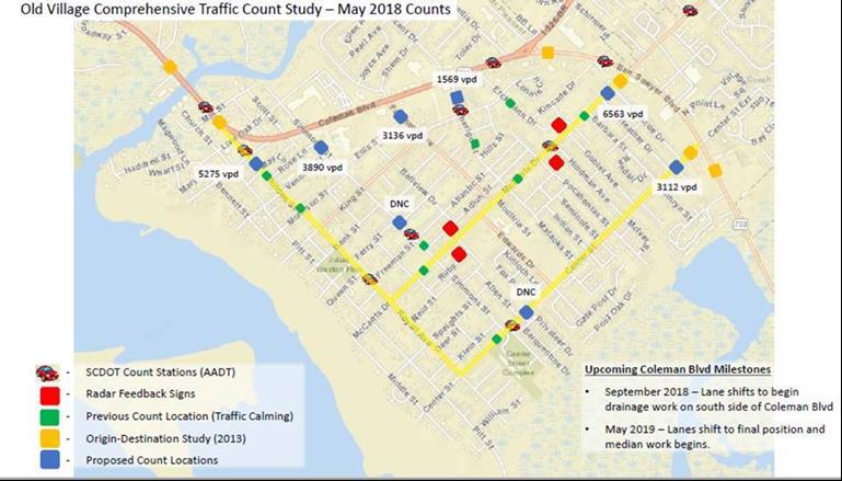
16 Transportation Committee Minutes November 5, 2018 Page 16 of 19 residents know they belong there and are not using the neighborhood for parking. Mayor Haynie asked if a motion was needed to direct staff to examine the issue. Mr. DeMoura replied in the negative, stating that staff would have information available at the next Committee meeting. Mayor Haynie directed staff to examine the feasibility of issuing parking passes and enforcement relating to parking issues in portions of the Old Village. Mr. DeMoura stated that if it the issue is more complicated, and the deadline cannot be met, the Committee would be informed. 5. Update of various traffic management issues Mayor Haynie stated that one of item for discussion was special events at Boone Hall Plantation and that he had received a personal message and noticed on social media that the traffic issues had improved. Mr. DeMoura stated that staff had prepared a graphic relating to Park West Boulevard and Stockdale Street. Mr. Cunnane asked if Boone Hall was part of the project updates or a separate agenda item. Mr. DeMoura stated that the reason event traffic at Boone Hall Plantation was smoother than prior weekends was that the Town applied more resources and those resources were at the Town s expense. Moving forward, staff will meet with the property owner and the County in an effort to recoup resources, noting that to keep that resource level available, it should not be the citizens burden. Mr. DeMoura stated that he has spoken with Mr. McRae several times and he was very receptive. Mr. McRae has also spoken with the County and it is his understanding that the County has changed their requirements, which could may come into play for this issue.
17 Transportation Committee Minutes November 5, 2018 Page 17 of 19 Mr. Cunnane noted that the Town applied our resources and asked if a patrol car that would normally be at a different location was assisting with the event or if the Town was paying overtime for an off-duty officer. Mr. DeMoura replied that the Town was paying overtime. Mr. Cunnane stated that it was his suggestion to cover the intersections and that it made a difference. Having talked with Mr. McRae, it was mentioned that last weekend was a traditionally lighter weekend than at the beginning of October. It may be beneficial for Mr. McRae to meet with staff from the Police department and the Transportation Department to identify the most intense weekends with the hope that someone else will pay for the additional traffic officers. Mr. DeMoura stated that staff understood the directive of the Committee to meet with Boone Hall relating to special events and extra resources from the Mount Pleasant Police Department. Mr. Brimmer noted that Boone Hall Plantation is in the County and their special events permit were issued through the County, questioning why there were no County Sheriff officers at the event. Mr. DeMoura stated that the County Sheriff officers were on site. Mr. Brimmer questioned why the Sheriffs were not managing traffic. Mr. DeMoura stated that the Town has made our position clear that more support is needed and if we cannot get the support, the funds should be made available to provide the support. Mr. DeMoura clarified that staff has approached the County and asked the County to provide the support and they have chosen not to do so. Mr. DeMoura stated that there is a level of service that needs to be provided for all the events to go smoothly and we do not believe that, until last weekend, services were at that level. There are two (2) options going forward: (1) the Town receives additional resources from somewhere else or (2) the Town is compensated for the support that is provided so that our tax payers do not have to bear the full burden of the additional expense.
18 Transportation Committee Minutes November 5, 2018 Page 18 of 19 Mr. Brimmer stated that it would be preferable to not just receive a check from Charleston County for providing services, because that is taking resources away from Mount Pleasant Residents. If this is a County event on County property, there should be County personnel providing those services alongside Mount Pleasant. Mayor Haynie stated that County Councilman Summey lives in Brickyard and could be an ally for this issue, commenting that Councilman Summey was having travel difficulties the weekend that the four (4) car accident occurred. The traffic issues that day were not a result of planning or mismanagement, it was a series of unfortunate events. From a County stand point, we have a receptive ear and it is important to send a unified message. Mayor Haynie commented that there were no residents from Park West present and asked if the traffic situation was better. Mr. Morrison stated that the radar feedback signs had been ordered and an alternative location for the feedback sign coming off Park West Boulevard had been identified. One (1) speed cushion has been located for Salterbeck Drive and staff is trying to locate hardware for installation. In the meantime, the Homeowners Association (HOA) has been given a petition to go through the standard traffic calming process. Update ongoing projects Mr. Lykins stated the stage 1 of the westbound improvements have been completed, except for a few sidewalk panels and plantings. Stage 2 began on October 17, 2018 and the contractor is working daytime hours in front of the Moultrie Middle School area with concentration on the section between Simmons Street and Fairmont Avenue and night work being performed in front of Brookgreen Town Center. The pavement is still rough in some areas and will be smoothed out with the steel plates removed as soon as possible. Mayor Haynie asked if the day work means that there will be no night work for a while. Mr. Lykins stated that there is night work in phase 2 and phase 2 encompasses the section form Fairmont Avenue to Pherigo Street, explaining that the
19 Transportation Committee Minutes November 5, 2018 Page 19 of 19 median is already in place, preventing lane shifts and making it necessary for lane closures at night. The day work is being performed in front of Moultrie Middle School. Waterworks has a few items that need to be completed at night and there is a section between Mill Street and Simmons Street relating to drainage that may require night work due to the proximity of some buildings being close to the edge of the road. Mr. Lykins stated that a public meeting was conducted on August 25, 2018, for the Patriots Point Gateway project. Although attendance was low, a lot of comments were received via in support of the bike lanes and enhanced bike markings. Mr. Cunnane asked for an update on the Long Point Road Extension project. Mr. Lykins stated that, as directed by the Committee, staff is continuing with the design of the road between Billy Swails Boulevard and Rifle Range Road and staff is studying alternate alignments between US 17 and Billy Swails Boulevard and the Committee will have a report in December. Adjourn There being no further business, the meeting was adjourned at 4:08 p.m. Respectfully submitted by, Cathy Godsey November 8, 2018


20 Town of Mt. Pleasant Transportation Committee November 5, 2018

21 Reasonable Alternatives Presented in May 2018 Alternative 1 Widening of Highway 41 to five lanes from Highway 17 to Clements Ferry Road Alternative 2 Widening existing Highway 41 to five lanes from Highway 17 to Joe Rouse Road, Highway 41 from Joe Rouse Road to Dunes West Boulevard would be widened to three lanes, and five lanes on Highway 41 from Dunes West Boulevard to Clements Ferry Road Alternative 7 Consists of a five lane roadway from Highway 17 to Bessemer Road., which would continue along Bessemer and Dunes West Boulevard to a five lane section on Highway 41 to Clements Ferry Road, making a continuous bypass around the Phillips Community
22 Refined Reasonable Alternatives May 2018 Public Meeting Reasonable Alternatives No Build Alternative 1 Alternative 2 Alternative 7 Summer/Fall 2018 Based on public comments Refinement & Modification Evaluation of: Alternatives 5a and 5b Alternative 7a We are here Refined Reasonable Alternatives No Build Alternative 1 Alternative 2 Alternative 7a
23 Refined Reasonable Alternatives Alternative 1 Widening of Highway 41 to five lanes from Highway 17 to Clements Ferry Road Alternative 2 Same as Alternative 1 except three lanes between Joe Rouse and Dunes West Blvd. Pedestrian improvements will be included in the final design

24 Refined Reasonable Alternatives Alternative 7a Widening of Highway 41 to five lanes from Highway 17 to south of Joe Rouse Road, -route re Highway 41 parallel to Bessemer Road and onto Laurel Hill County Park property, turn along the power line easement and then along Dunes West Blvd., and then back onto Highway 41 to the Wando River Bridge Existing Highway 41 through the Phillips Community would be improved to a three lane section Pedestrian improvements will be included in the final design
25 Additional Improvements Connection to Billy Swails Boulevard Currently evaluating options to connect Highway 41 with Billy SwailsBlvd. The distance between Highway 17 and Billy SwailsBlvd. is approximately 0.5m Interim Improvements Improvements to Highway 41 from Joe Rouse Road to Highway 17 with minor intersection improvements at Highway 41 and Highway 17 Evaluated cost estimates Reviewed traffic analyses Evaluating options internally to determine if options are feasible

26

27 Contact Us Visit: CAL OYER, P.E. Project Manager us to leave comments or join the project mailing list: Leave a message for the team project Follow Charleston County on Facebook and Twitter Charleston County Transportation Development coyer@charlestoncounty.org


28 Traffic Concerns in the Abbey Subdivision in Park West
29 Transportation CIP Project Updates November, 2018
30 Ongoing CIP Construction Coleman Boulevard Revitalization
31 New 2018 CIP Design Long Point Road Extension Coleman Boulevard and Patriot s Point Intersection Improvements Billy Swails Boulevard Phase 4B Shem Creek Bridge Bike Lanes Park West Boulevard Widening All American Boulevard Extension Maritime Port District Improvements Park West Boulevard and Stockdale Street Improvements
32 Coleman Boulevard Revitalization Contractor: Blythe Development Start Date: September 11, 2017 Completion Date: December 27, 2019 Status: Stage 1 Westbound Temporary paving on Coleman westbound lanes is complete. All drainage, sidewalk and curb is complete. Lighting and landscaping is complete. Stage 2 Eastbound - Traffic control shift was completed on October 17. Contractor making excellent progress on this side of Coleman installing storm drainage pipe.
33 Coleman Boulevard Revitalization Project Progress as of October 31, Feet of Storm Drain 45 Drainage Structures 3 Water Quality Treatment Devices 2,700 Feet of Curb and Gutter 2,500 Feet of Sidewalk 2,000 Feet of Lighting and Irrigation Conduits Simmons Street Force Main Relocation Simmons Street Gravity Sewer Relocation Simmons Street Gravity Sewer Repair Simmons Street Paving Fairmont Avenue Force Main Relocation 2,400 Feet of New Waterline on Coleman 3 Waterline Relocations Completed

34
35 Long Point Road Extension Project Cost Estimate: $16,810,000 Fully funded via adoption of CIP Designer: JMT Completion Date: Design: September 2019 Construction: September 2022 Status: Currently analyzing alignment alternatives between US 17 and Billy Swails Blvd. per Council direction. Report of these alternatives in December. Design of road between Billy Swails Blvd. and Rifle Range


36 Boone Hall Plantation Christ Church

37
38 Patriot s Point Gateway Intersection Improvements Project Cost Estimate: $6,765,800 Fully funded via adoption of CIP Consultant: STV Incorporated Completion Date: Design: February 2019 Permitting: June 2019 Construction: December June 2021 Status: Right of Way plans to be submitted for review this month. Utility coordination is ongoing. PIM held on October 25.

39
40 Billy Swails Boulevard 4B Project Cost Estimate: $12,568,497 ($2,568,497 TOMP and $10,000,000 Federal) Designer: Stantec Consulting Services, Inc. Completion Date: Design: August 2020 Construction: August 2022 Status: Currently, several alignment alternatives are being reviewed through the NEPA process. Wetlands have been delineated and most field work has been completed. Traffic study is completed in a draft format and will be finalized when the preferred alignment

41
42 Shem Creek Bridge Bike Lanes Project Cost Estimate: $791,000 ($158,000 TOMP and $633,000 Federal) Consultant: CDM Smith Completion Date: Design: December 2018 Construction: December 2019 Status: Held public information meeting. Currently developing preliminary plans and awaiting SCDOT approval of Project Planning Report and design exception.

43
44 Park West Boulevard Widening Project Cost Estimate: $8,517,445 Fully funded via adoption of CIP Consultant: Mead and Hunt Completion Date: Design: December 2018 Construction: June 2021 Status: The roundabout design has been revised to delete additional ROW needs from Foxmoor HOA property. Utility coordination and engineering is ongoing. Final design to be completed in December.

45
46 All American Boulevard Extension Project Cost Estimate: $5,171,000 Fully funded via adoption of CIP Consultant: Mead and Hunt Design: March December 2019 Construction: March 2020 December 2021 Status: Designer is currently working on alignment alternatives. Wetlands have been delineated. Phase 1 designer under contract for plan revisions and right of way acquisition for that phase.

47
48 Maritime Port District Improvements Study Project Cost Estimate: $163,458 for concept study $1,500,000 funded via adoption of CIP Consultant: CDM Smith Concept Study: August January 2019 Construction: NA Status: Field Surveys are underway. Traffic field work completed. Meetings with SCSPA and other stakeholders are planned.

49 Intersection Improvements Roadway Extension Corridor Analysis and Cross Section Study
50 Park West Boulevard and Stockdale Street Improvements Project Cost Estimate: Concept Design: $200,000 Consultant: Mead and Hunt Concept Study: October September 2019 Construction: NA Status: Staff currently reviewing proposal and scope of work from Mead and Hunt to begin intersection concept study.

51 PARK WEST BOULEVARD AND STOCKDALE STREET IMPROVEMENTS Intersection Improvement
52 Transportation Sales Tax (TST) Projects Park West Boulevard sidewalk from Stockdale Street to the recreation complex is complete. Anna Knapp Boulevard sidewalk from Johnnie Dodds Boulevard to Hibben Ferry is complete. Belle Hall Parkway and Paul Foster Mini Roundabout.
53 Charleston Transportation Committee (CTC) Projects Pelzer Drive sidewalk is complete Lansing Drive sidewalk project is currently under design. Seacoast Parkway sidewalk project is currently in design and additional right of way needs are being evaluated. Cottingham Drive sidewalk design to be funded next year.
54 Other Projects SC 41 Widening Patriot s Point Realignment Maritime Port District Project kick-off meeting held. Surveying and field data collection is underway. Belle Hall Queue Lane Complete. Wando Park S/W Complete. OV Traffic Study Ongoing. Signals Ben Sawyer Boulevard/Center Street, US17/Faison Road, SC41/Harpers Ferry Way. Park West Blvd & Stockdale Street Improvements


55 Belle Hall Parkway at Paul Foster Road Mini Roundabout

56 Houston Northcutt Boulevard Transit Shelter
57
TOWN OF MOUNT PLEASANT, SOUTH CAROLINA TRANSPORTATION COMMITTEE
 TOWN OF MOUNT PLEASANT, SOUTH CAROLINA TRANSPORTATION COMMITTEE Monday, December 3, 2018 Municipal Complex, Committee Meeting Room, 3 rd Floor 100 Ann Edwards Lane Mount Pleasant, SC 29464 MINUTES Members
SC 41/Joe Rouse Intersection Improvements
 SC 41/Joe Rouse Intersection Improvements Scope: Add dual left-turn lanes from Joe Rouse Road onto southbound SC 41 to reduce re-occurring peak hour congestion, particularly the AM peak. Construction Cost
AGENDA REPORT. Issue: Discussion of potential improvements on Barnwell Road at Niblick Drive
 AGENDA REPORT To: From: By: Honorable Mayor and City Council Members Warren Hutmacher, City Manager Tom Black, Public Works Director Date: March 23, 2016 Agenda: March 28, 2016 WORK SESSION AGENDA: Barnwell
Tonight is for you. Learn everything you can. Share all your ideas.
 Strathcona Neighbourhood Renewal Draft Concept Design Tonight is for you. Learn everything you can. Share all your ideas. What is Neighbourhood Renewal? Creating a design with you for your neighbourhood.
Project Update May 2018
 Project Update May 2018 Dakota County, in cooperation with the City of Lakeville, is planning to reconstruct 202 nd Street West (County Road 50) from Holyoke Avenue to Cedar Avenue (County Road 23). 202
West Dimond Blvd Upgrade Jodhpur Street to Sand Lake Road
 West Dimond Blvd Jodhpur St to Sand Lake CSS Transportation Project Summary Municipality of Anchorage Project # 05 005 Project Manager: John Smith, P.E. (MOA PM&E) Project Administrator: Julie Makela,
Caltrans Sloat Boulevard Pedestrian Safety Project Response to Community Questions, Comments & Concerns
 Caltrans Sloat Boulevard Pedestrian Safety Project Response to Community Questions, Comments & Concerns Revised: May 10, 2016 The California Department of Transportation (Caltrans) is planning various
Prepared By: Town of Waxhaw Traffic Calming Policy
 Policy For Resolutions for Town Meetings Prepared By: Town Manager Michael McLaurin Director Greg Mahar CPD Waxhaw N.C. Community Planning &Development Administrative Department Department: Date Approved
Project Overview. Rolling Road Widening Fairfax County. Get Involved. Design Public Hearing. Contact Information
 Get Involved VDOT representatives will review and evaluate information received as a result of this meeting. Please fill out the comment sheet provided in this brochure if you have any comments or questions.
Item No. 14 Town of Atherton
 Item No. 14 Town of Atherton CITY COUNCIL STAFF REPORT CONSENT AGENDA TO: THROUGH: FROM: HONORABLE MAYOR AND CITY COUNCIL GEORGE RODERICKS, CITY MANAGER MICHAEL KASHIWAGI, COMMUNITY SERVICES DIRECTOR MARTY
NEIGHBORHOOD TRAFFIC CALMING PROGRAM. Policy and Procedure. Roswell Department of Transportation (770)
") NEIGHBORHOOD TRAFFIC CALMING PROGRAM Policy and Procedure Roswell Department of Transportation (770) 594 6420 Approved by M&CC on December 19, 2011 Table of Contents 1. Application and Intent 2. Program
NEIGHBORHOOD TRAFFIC CALMING PROGRAM Policy and Procedure Roswell Department of Transportation (770) 594 6420 Approved by M&CC on December 19, 2011 Table of Contents 1. Application and Intent 2. Program
Legislative Update Williamsburg Residency
 Hampton Roads District Legislative Update Williamsburg Residency Jim Brewer, Resident Administrator 757-253-5140 Projects Under Way Warwick Boulevard Project http://www.warwickboulevard.org/ Contractors:
SAN FRANCISCO MUNICIPAL TRANSPORTATION AGENCY
 THIS PRINT COVERS CALENDAR ITEM NO. : 11 DIVISION: Sustainable Streets BRIEF DESCRIPTION: SAN FRANCISCO MUNICIPAL TRANSPORTATION AGENCY Approving traffic modifications on Twin Peaks Boulevard between Christmas
Residential Traffic Calming Program Guide. Town of Ashland, Virginia
 Residential Traffic Calming Program Guide Town of Ashland, Virginia August 1, 2006 TABLE OF CONTENTS A. INTRODUCTION... 1 B. GOALS... 1 C. CRITERIA... 1 D. IDENTIFYING NEIGHBORHOOD TRAFFIC CONCERNS...
2011 Capital Projects University Area - Community Council Priority List Municipality of Anchorage
 2011 Capital Projects University Area - Community Council Priority List Municipality of Anchorage 2 Project Management and Engineering Projects on 40th Ave Extension - Lake Otis Pkwy to Dale St $18,103,000
WEST AND SOUTH WEST RING ROAD DOWNSTREAM TRAFFIC IMPACTS
 Page 1 of 9 EXECUTIVE SUMMARY Alberta Transportation ( AT ) is preparing to construct the final sections of the Calgary Ring Road. This includes the South West Ring Road ( SWRR ) (from Lott Creek Blvd
1. What is the Doran Street and Broadway/Brazil Grade Separation Project (Project)?
?") 1. What is the Doran Street and Broadway/Brazil Grade Separation Project (Project)? The Los Angeles County Metropolitan Transportation Authority (Metro) is evaluating the development of a grade separation
1. What is the Doran Street and Broadway/Brazil Grade Separation Project (Project)? The Los Angeles County Metropolitan Transportation Authority (Metro) is evaluating the development of a grade separation
CITY OF SAINT JOHN TRAFFIC CALMING POLICY
 CITY OF SAINT JOHN TRAFFIC CALMING POLICY VERSION: 1.0 April 10, 2012 Pedestrians, Cyclists and Motorists Sharing Street Spaces CONTENTS INTRODUCTION... 3 POLICY GOAL... 3 POLICY OBJECTIVES... 3 GUIDING
BUDGET FOR RESEDA BOULEVARD, STREET RECONSTRUCTION / VISION ZERO PROGRAM, REPORT BACK, COUNCIL FILE
 FORM GEN. 160 (Rev. 11-02) CITY OF LOS ANGELES INTERDEPARTMENTAL CORRESPONDENCE Date: To: Honorable City Council From: Gary Lee Moore, City Engineer Bureau of Engineering 7%mt /Electronically signed by
Brian McHugh, Buckhead Community Improvement District. SUBJECT: Wieuca Road at Phipps Boulevard Intersection Improvements Project
 MEMO TO: FROM: Brian McHugh, Buckhead Community Improvement District Jagan Kaja, AICP, WSP Parsons Brinckerhoff SUBJECT: Wieuca Road at Phipps Boulevard Intersection Improvements Project DATE: October
Solana Beach Comprehensive Active Transportation Strategy (CATS)
") Solana Beach Comprehensive Active Transportation Strategy (CATS) 3.0 Goals & Policies The Solana Beach CATS goals and objectives outlined below were largely drawn from the Solana Beach Circulation Element
Solana Beach Comprehensive Active Transportation Strategy (CATS) 3.0 Goals & Policies The Solana Beach CATS goals and objectives outlined below were largely drawn from the Solana Beach Circulation Element
WELCOME. Stakeholder Involvement Group Meeting #2 Round Lake Public Works October 24, 2018
 WELCOME Stakeholder Involvement Group Meeting #2 Round Lake Public Works October 24, 2018 MEETING AGENDA 1. Welcome and Introductions 2. Study Progress Update 3. Problem Statement 4. Technical Analysis
NEIGHBORHOOD TRAFFIC CALMING POLICY
 NEIGHBORHOOD TRAFFIC CALMING POLICY I. PURPOSE The City of Kent continually strives to strengthen and protect its neighborhoods by improving the quality of life in residential areas. Traffic conditions
HOOPA DESIGN FAIR 4. IMPLEMENTATION PHASES & FUNDING
 4. IMPLEMENTATION PHASES & FUNDING HOOPA DESIGN FAIR 4-1 4. IMPLEMENTATION PHASES & FUNDING Phase One Development 1. Implementation The Conceptual Plan recommends five concept elements to revitalize downtown
4 DISRUPTION MANAGEMENT PLAN HIGHWAY 7 RAPIDWAY CONSTRUCTION BETWEEN BAYVIEW AVENUE AND WARDEN AVENUE TOWNS OF MARKHAM AND RICHMOND HILL
 4 DISRUPTION MANAGEMENT PLAN HIGHWAY 7 RAPIDWAY CONSTRUCTION BETWEEN BAYVIEW AVENUE AND WARDEN AVENUE TOWNS OF MARKHAM AND RICHMOND HILL The Transportation Services Committee recommends the adoption of
APPENDIX G: INTERSECTION NEEDS AT OKEECHOBEE BOULEVARD
 APPENDIX G: INTERSECTION NEEDS AT OKEECHOBEE BOULEVARD INTERSECTION NEEDS AT SR 7 and OKEECHOBEE BOULEVARD SR 7 Extension Project Development and Environment (PD&E) Study From Okeechobee Boulevard (SR
Application of a Complete Street
 Application of a Complete Street Southbend to Prima Vista Update May 14, 2018 Meeting Agenda Perspective and History Public input received Typical sections being considered Presentation of the 2-lane master
5.0 Roadway System Plan
 Southwest Boise Transportation Study Page 16 5.0 Roadway System Plan The Roadway System Plan outlines roadway improvements in the Initial Study Area. It forecasts future deficiencies on the arterial system,
Memorandum. Sunday, July 13, Saturday, July 19, 2014
 Memorandum To: David Lowin, Brooklyn Bridge Park Corporation From: Daniel Schack, AICP, PTP Date: Re: Brooklyn Bridge Park Pier 5/6 Loop Road Traffic Study Project No: 14-01-2407 At the request of Brooklyn
City of Vestavia Hills Traffic Calming Policy for Residential Streets
 City of Vestavia Hills Traffic Calming Policy for Residential Streets PURPOSE: The purpose of the Traffic Calming Policy for Residential Streets is to address safety concerns related to vehicular traffic
Owl Canyon Corridor Project Overview and Summary
 Owl Canyon Corridor Project Overview and Summary December 22, 2008 The Owl Canyon corridor (generally the connection between the I-25 / Larimer County Road 70 interchange and the US 287 / Larimer County
Summary: Mercer County Princeton Avenue & Spruce Street Study January 2009
 Summary: Several recent studies have assessed potential development and redevelopment opportunities in the Mercer Crossing area of Trenton, Ewing, and Lawrence. This Princeton Avenue and Spruce Street
Complete Streets. Designing Streets for Everyone. Sarnia
 Complete Streets Designing Streets for Everyone Sarnia Complete Streets ~ Sarnia ~ 2018 Introduction Our City is made up of a network of streets that we use to go for a walk, cycle to work, drive to the
BUSINESS OF THE CITY COUNCIL CITY OF MERCER ISLAND, WA
 BUSINESS OF THE CITY COUNCIL CITY OF MERCER ISLAND, WA AB 4087 May 1, 2006 Regular Business PEAK PROJECT UPDATE - CITY RELATED ISSUES Proposed Council Action: Receive update. No action required. DEPARTMENT
Governance and Priorities Committee Report For the July 2, 2015 Meeting
 CITY OF VICTORIA For the July 2, 2015 Meeting To: Governance and Priorities Committee Date: From: Subject: Brad Dellebuur, A/Assistant Director, Transportation and Parking Services Executive Summary The
Corporate. Report COUNCIL DATE: May 25, 1998 NO: R1500 REGULAR COUNCIL. TO: Mayor & Council DATE: April 27, 1998
 R1500 : Traffic Safety at 25 Avenue and 128 Street Intersection Corporate NO: R1500 Report COUNCIL DATE: May 25, 1998 REGULAR COUNCIL TO: Mayor & Council DATE: April 27, 1998 FROM: General Manager, Engineering
Los Altos Hills Town Council - June 18, 2015 Palo Alto City Council June 22, AGENDA ITEM #2.B Presentation
 Los Altos Hills Town Council - June 18, 2015 Palo Alto City Council June 22, 2015 AGENDA ITEM #2.B Presentation Previous Presentations Los Altos Hills Town Council in May 2014 and February 2015 Palo Alto
CITY OF VISTA TRAFFIC CALMING PROGRAM
 CITY OF VISTA TRAFFIC CALMING PROGRAM The purpose of the Vista Traffic Calming Program is to reduce speeds of motorists driving through residential neighborhoods. The program does not apply to nonresidential
Omaha s Complete Streets Policy
 Omaha s Complete Streets Policy (Adopted August 2015) VISION To create great places and enhance our quality of life, the City of Omaha will provide safe, accessible streets for all users. Complete Streets
Chapter 3: Multi-Modal Circulation and Streetscapes
 CHAPTER 3: MULTI-MODAL CIRCULATION AND STREETSCAPES Chapter 3: Multi-Modal Circulation and Streetscapes Overview Streetscape improvements have already been completed for Depot Street between Main Avenue
Neighborhood Traffic Calming Program
 Neighborhood Traffic Calming Program Adopted by Town Council on: October 23 rd, 2007 Resolution #: 2007-124 PROPOSED REVISIONS February 8, 2012 pg. 1 TABLE OF CONTENTS 1.0 INTRODUCTION...3 2.0 PROGRAM
Citizen Advisory Group Meeting #8 May 5, Welcome. Today s meeting will focus on: Land Use & Transportation CHARLOTTEPLANNING.
 Citizen Advisory Group Meeting #8 May 5, 2010 Welcome. Today s meeting will focus on: Land Use & Transportation CHARLOTTEPLANNING.ORG Meeting Agenda Handouts: o Meeting Agenda o Summary of East Seventh
APPENDIX 2 LAKESHORE ROAD TRANSPORTATION REVIEW STUDY EXECUTIVE SUMMARY
 APPENDIX 2 LAKESHORE ROAD TRANSPORTATION REVIEW STUDY EXECUTIVE SUMMARY Appendix 2 City of Mississauga Lakeshore Road FINAL REPORT Transportation Review Study December 2010 EXECUTIVE SUMMARY Study Purpose
Community Transportation Plan
 Community Transportation Plan Appendix A: Traffic Calming CITY OF DECATUR COMMUNITY TRANSPORTATION PLAN Appendix A: City of Decatur City-wide Residential Traffic Calming Program Process & Procedures The
122 Avenue: 107 Street to Fort Road
 : 107 Street to Fort Road November 24, 2015 4:30 8:00 p.m. Meeting Purpose Summarize project work completed to date Share results of public input from Phase 1 Share the draft concept plan and proposed
NOTES OF MEETING AIRPORT ROAD (KING STREET TO HUNTSMILL DRIVE) ENVIRONMENTAL ASSESSMENT (EA) COMMUNITY WORKING GROUP (CWG) ORIENTATION SESSION
 ENVIRONMENTAL ASSESSMENT (EA) COMMUNITY WORKING GROUP (CWG) ORIENTATION SESSION") NOTES OF MEETING AIRPORT ROAD (KING STREET TO HUNTSMILL DRIVE) ENVIRONMENTAL ASSESSMENT (EA) COMMUNITY WORKING GROUP (CWG) ORIENTATION SESSION Thursday, November 30, 2017 6:00 p.m. 8:00 p.m. Caledon Community
NOTES OF MEETING AIRPORT ROAD (KING STREET TO HUNTSMILL DRIVE) ENVIRONMENTAL ASSESSMENT (EA) COMMUNITY WORKING GROUP (CWG) ORIENTATION SESSION Thursday, November 30, 2017 6:00 p.m. 8:00 p.m. Caledon Community
Improve the livability of our streets by
 Pedestrian and Traffic Calming Policy March 2018 2 of 6 Neighborhood Traffic Calming Policy The City of Aspen continually strives to protect multimodal function while maintaining a high standard of safety.
NORTH HIGHLAND LAKE ROAD PROJECT
 NORTH HIGHLAND LAKE ROAD PROJECT The purpose of this special newsletter is to inform the residents of Flat Rock about the facts concerning the proposed N. Highland Lake Road Project and clarify some misconceptions.
CITY OF ROHNERT PARK CITY COUNCIL AGENDA REPORT
 Meeting Date: May 10, 2016 Department: Submitted By: Prepared By: Agenda Title: Mission Statement We Care for Our Residents by Working Together to Build a Better Community for Today and Tomorrow. CITY
SANTA MONICA BOULEVARD CORRIDOR
 CIRCULATION ELEMENT WHITE PAPER NO. 3 SANTA MONICA BOULEVARD CORRIDOR INTRODUCTION From the 1930s to the beginning of Los Angeles freeway era, Santa Monica Boulevard, (previously Route 66, the Beverly
Shore Drive Safety Task Force. Report to the SDAC
 Shore Drive Safety Task Force Report to the SDAC April 20, 2006 Table of Contents Introduction... 3 Section I Safety Recommendations... 5 Section II Communication/Public Involvement Plan... 14 Section
BETHEL ROAD AND SEDGWICK ROAD CORRIDOR STUDY
 DRAFT PLAN City Council Meeting August 14, 2017 STUDY AREA Sedgwick Corridor State Route 160, principal arterial with Class 3 access management designation, commuter and freight route, connection to SR
Lee s Summit Road Improvement Study Public Open House June 7, 2007 Summary of Comment Card Responses
 Lee s Summit Road Improvement Study Public Open House June 7, 2007 Summary of Comment Card Responses Introduction At the Lee s Summit Road Improvement Study Public Open House held Thursday, June 7, 2007
VDOT I-66 Inside the Beltway Eastbound Widening Environmental Assessment. Staff Recommendations
 VDOT I-66 Inside the Beltway Eastbound Widening Environmental Assessment Staff Recommendations Department of Environmental Services Transportation January 28, 2017 Timeline of Transform66 June 2012: I-66
Public Information Meeting
 Richmond Highway (U.S. Route 1) Corridor Improvements Public Information Meeting Tuesday, April 18, 2017 Mount Vernon High School 8515 Old Mt. Vernon Road, Alexandria, VA 22309 Amanda Baxter, VDOT, Special
Project Report. South Kirkwood Road Traffic Study. Meadows Place, TX October 9, 2015
 Meadows Place, TX October 9, 2015 Contents 1 Introduction... 1 2 Data Collection... 1 3 Existing Roadway Network... 2 4 Traffic Volume Development... 2 5 Warrant Analysis... 3 6 Traffic Control Alternative
BD RESOLUTION NO RESOLUTION ADOPTING THE VISION ZERO RAMP INTERSECTION STUDY PHASE 1
 BD00 RESOLUTION NO. - RESOLUTION ADOPTING THE VISION ZERO RAMP INTERSECTION STUDY PHASE [NTIP PLANNING] FINAL REPORT WHEREAS, The Vision Zero Ramp Intersection Study Phase was recommended by Commissioner
Princeton Avenue and Spruce Street Transportation and Site Access Enhancements Project
 Princeton Avenue and Spruce Street Transportation and Site Access Enhancements Project Mercer County Planning Division AECOM Transportation (formerly DMJM Harris) January 29, 2009 Agenda Project Status
2014/2015 BIKE ROUTE PLAN 83 AVENUE PROTECTED BIKE LANE
 About the Project 2014/2015 BIKE ROUTE PLAN The City of Edmonton is planning a major bike route on the south side of Edmonton. This bike route is one part of a plan to provide citizens with transportation
REPORT CONCURRENCE. City Manager. The General Manager concurs with the recommendation of this report.
 COUNCIL REPORT Report No. ENG 08-018 Executive Committee Date: May 0, 018 File No: 5400-1 To: From: Subject: Mayor and Council Purvez Irani, Senior Transportation Engineer Bluejay Street Road Improvements
Safe Routes to School Action Plan Aberdeen, Idaho
 Background Aberdeen, Idaho is a largely agricultural community of nearly 2,000 people and is located in the southeast portion of the state on the western edge of American Falls Reservoir. The community
Broad Street Bicycle Boulevard City Council Study Session Summary
 Broad Street Bicycle Boulevard City Council Study Session Summary Overview: On August 15 th, 2017, a City Council Study Session was held to invite community input and request City Council guidance on a
BLUETT TRAFFIC CALMING ON-SITE MEETING #2 DISCUSSION SUMMARY
 BLUETT TRAFFIC CALMING ON-SITE MEETING #2 DISCUSSION SUMMARY Date: Wednesday, April 11, 2018 Time: 5:30 p.m. to 7:30 p.m. Location: Clague Middle School parking lot Attendees: Public Present: 42 Council
Draft Traffic Calming Policy Paper
 Draft Traffic Calming Policy Paper What is Traffic Calming The term traffic calming is defined differently throughout the United States. The Institute of Transportation Engineers, an international educational
Giles Run Connector Road
 Giles Run Connector Road Laurel Hill Adaptive Reuse Area to Laurel Crest Drive South County Federation Meeting June 14, 2016 History Connector road included in the Laurel Hill Comprehensive Plan amendment
Southbend to Prima Vista. October 30, Floresta Corridor Master Plan
 Application of a Complete Street initiative and how it might function operationally 8 8 Southbend to Prima Vista October 30, 2017 Presentation Agenda 2 Perspective and History Traffic projections, Levels
Lewelling Boulevard Improvements Response to Questions/Comments From October 9, 2001 Community Meeting
 Lewelling Boulevard Improvements Response to Questions/Comments From October 9, 2001 Community Meeting Group 1 Questions/Comments (Topic: Impact to Properties) How many residential/business properties
North Shore Transportation Improvement Strategy
 North Shore Transportation Improvement Strategy Preliminary, Near-term Recommendation 2016 April Transportation Improvement Strategy (TIS) Comprehensive and Analytical A multi-modal transportation strategy
Purpose: Financial Implications and Impact Statement: It is estimated that the cost to implement:
 Various Modifications Lower Jarvis Street and Lake Shore Boulevard East; Lower Jarvis Street, east side, between Lake Shore Boulevard East and The Esplanade - 45-77 Lower Jarvis Street; and Lower Jarvis
Fairfax County Parkway Widening Fairfax County
 Get Involved VDOT representatives will review and evaluate information received as a result of this meeting. Please fill out the comment sheet provided in this brochure if you have any comments or questions.
Roadway Classification Design Standards and Policies. Pueblo, Colorado November, 2004
 Roadway Classification Design Standards and Policies Pueblo, Colorado November, 2004 Table of Contents Page Chapter 1. General Provisions 1.1 Jurisdiction 3 1.2 Purpose and Intent 3 1.3 Modification 3
Highway 49, Highway 351 and Highway 91 Improvements Feasibility Study Craighead County
 Highway 49, Highway 351 and Highway 91 Improvements Feasibility Study Craighead County Executive Summary March 2015 Highway 49, Highway 351 and Highway 91 Improvements Feasibility Study Craighead County
REPORT. Engineering and Construction Department
 REPORT COMMUNITY SERVICES COMMITTEE MEETING DATE: JUNE 11, 2013 FROM: Engineering and Construction Department DATE: May 24, 2013 SUBJECT: Great Lakes Boulevard Mini Roundabout LOCATION: Great Lakes Boulevard
Brooklyn Boulevard (County Road 152) Reconstruction Project Phase I. OPEN HOUSE June 20, 2017
 Reconstruction Project Phase I. OPEN HOUSE June 20, 2017") Brooklyn Boulevard (County Road 152) Reconstruction Project Phase I OPEN HOUSE June 20, 2017 Brooklyn Boulevard (County Road 152) Phase I Project Partners Project Lead Other Project Partners include Brooklyn
Brooklyn Boulevard (County Road 152) Reconstruction Project Phase I OPEN HOUSE June 20, 2017 Brooklyn Boulevard (County Road 152) Phase I Project Partners Project Lead Other Project Partners include Brooklyn
Reference number /VP. Lafayette Downtown Congestion Study - Additional Traffic Analysis
 To James Hinkamp and Tony Coe, City of Lafayette Date January 19, 2017 Copies Reference number 243381/VP From Michael Iswalt and Vanessa Peers File reference 4-05 Subject Lafayette Downtown Congestion
City of Sammamish. Welcome. Issaquah-Fall City Road Improvements Project Phase I Design: 242nd Avenue SE to Klahanie Drive SE
 Welcome Welcome to the third community meeting for the Issaquah-Fall City Road Improvements Project. AGENDA 6:00 p.m. Welcome and sign-in 6:10 p.m. Presentation 6:50 p.m. Open house Learn about the roadway
Summary of Comments Public Meeting: Marietta Street Resurfacing Project Atlanta Contemporary August 29, 2017 / 6:00 pm to 8:00 pm
 Renew Atlanta hosted a public meeting to discuss the Marietta Street Resurfacing project at. Councilmember Cleta Winslow attended the public meeting, where over seventy (70) citizens to include representatives
Exhibit 1 PLANNING COMMISSION AGENDA ITEM
 Exhibit 1 PLANNING COMMISSION AGENDA ITEM Project Name: Grand Junction Circulation Plan Grand Junction Complete Streets Policy Applicant: City of Grand Junction Representative: David Thornton Address:
AGENDA ITEM SUMMARY SPECIAL AGENDA ITEM NO. _1A_
 AGENDA ITEM SUMMARY AGENCY: City Council MEETING DATE: June 25, 2012 DEPARTMENT: Community Dev PREPARED BY: T Spade DEPT. DIR. APPROVAL: MJ CITY MGR. APPROVAL: LR PRESENTED BY: T Spade TITLE: RECEIVE REPORT
4APNOIPF Vh, YII PTC CITY COUNCIL AGENDA REPORT. Honorable Mayor and City Council Members. 8K TH 63 River Crossing Bridge Replacement Project
 City of RE 4APNOIPF Vh, X` W\ YII PTC ING, CITY COUNCIL AGENDA REPORT Council Meeting Date: September 26, 2016 To: From: Agenda Item: Honorable Mayor and City Council Members Ron Rosenthal, Engineering
Corpus Christi Metropolitan Transportation Plan Fiscal Year Introduction:
 Introduction: The Safe, Accountable, Flexible, Efficient Transportation Equity Act: A Legacy for Users (SAFETEA-LU) has continued the efforts started through the Intermodal Surface Transportation Efficiency
WHEREAS delivery trucks also pass through the Narrows, into the northern parking lot, to loading docks in the back of the building.
 CEDAR-ISLES-DEAN NEIGHBORHOOD ASSOCIATION ( CIDNA ) RESOLUTION OPPOSING A DRUG STORE DRIVE THRU, AND COMMENDING DORAN COMPANIES FOR PROPOSING MITIGATING AMENITIES INCLUDING NEW LANDSCAPING AND A DEDICATED
Report Purpose To seek Council s approval of the Wye Road Functional Planning Study (January 2015).
.") COUNCIL MEETING Meeting Date: March 10, 2015 Agenda Item #: 13.1 Wye Road Functional Planning Study (January 2015) Report Purpose To seek Council s approval of the Wye Road Functional Planning Study (January
COUNCIL MEETING Meeting Date: March 10, 2015 Agenda Item #: 13.1 Wye Road Functional Planning Study (January 2015) Report Purpose To seek Council s approval of the Wye Road Functional Planning Study (January
Environmental Assessment Findings & Recommendations. Public Hearing November 13, 2014
 Environmental Assessment Findings & Recommendations Public Hearing November 13, 2014 Welcome! Welcome and Introductions Project and Environmental Assessment Overview Public Comments Adjourn Purpose of
Portland International Airport Bicycle and Pedestrian Plan (October 2003) Staff Acknowledgements
 Staff Acknowledgements") Portland International Airport Bicycle and Pedestrian Plan (October 2003) Staff Acknowledgements Scott King, Senior Aviation Planner Jason Gately, Senior Aviation Planner Preston Beck, Associate Planner
Portland International Airport Bicycle and Pedestrian Plan (October 2003) Staff Acknowledgements Scott King, Senior Aviation Planner Jason Gately, Senior Aviation Planner Preston Beck, Associate Planner
TO: Board Members Vancouver Park Board FROM: General Manager Parks and Recreation SUBJECT: Seaside Greenway Improvements
 Date: October 1, 2013 TO: Board Members Vancouver Park Board FROM: General Manager Parks and Recreation SUBJECT: Seaside Greenway Improvements RECOMMENDATION A. THAT the Board approve the new bike paths
DEPARTMENT OF PUBLIC WORKS Carroll County, Maryland
 DEPARTMENT OF PUBLIC WORKS Carroll County, Maryland Prepared by the Bureau of Engineering 225 North Center Street, Room 221, Westminster, MD 21157 (410) 386-2157 e-mail: trafficcalming@ccg.carr.org http://ccgovernment.carr.org/trafficcalming
5 Transit & Traffic. Overview
 5 Transit & Traffic Overview Montgomery Place s roadways and overall traffic circulation are unique in the city due to the narrow streets and avenues with boulevards; however, no sidewalks or curbs in
CITY OF COCONUT CREEK IMPLEMENTATION GUIDELINES FOR TRAFFIC CALMING
 CITY OF COCONUT CREEK IMPLEMENTATION GUIDELINES FOR TRAFFIC CALMING I. Introduction: The City of Coconut Creek recognizes that the conditions of residential streets can greatly affect neighborhood livability;
TRANSPORTATION COMMISSION East 19 th St, Harper to O Connell Thursday, March 29, :00 PM City Commission Room, City Hall, 6 E.
 TRANSPORTATION COMMISSION East 19 th St, Harper to O Connell Thursday, March 29, 2018 6:00 PM City Commission Room, City Hall, 6 E. 6th Street AGENDA Public comment related to the meeting topic will be
Citizens Handbook for Requesting Traffic Calming Devices
 Citizens Handbook for Requesting Traffic Calming Devices January 19, 2015 Table of Contents 1. PURPOSE... - 1-2. DEFINITIONS... - 2-3. GENERAL INFORMATION... - 3-3.1. ELIGIBILITY REQUIREMENTS... - 3-3.2.
EXHIBIT R1. Neighborhood Cul-de-Sac Implementation
 Neighborhood Cul-de-Sac Implementation The traffic study conducted for the Talaria project analyzed the amount of project traffic expected to use local, residential streets immediately north of the project
5 CIRCULATION AND STREET DESIGN
 5 CIRCULATION AND STREET DESIGN This chapter describes circulation and streetscape improvements proposed for the Northwest Chico Specific Plan Area. It includes detailed design specifications for existing
Basalt Creek Transportation Refinement Plan Recommendations
 Basalt Creek Transportation Refinement Plan Recommendations Introduction The Basalt Creek transportation planning effort analyzed future transportation conditions and evaluated alternative strategies for
Executive Summary Route 30 Corridor Master Plan
 Route Corridor Master Plan Project Overview The Route Corridor Master Plan is a coordinated multimodal transportation and land use plan for the entire stretch of Route through East Whiteland Township,
ADA TRANSITION PLAN 2013
 ADA TRANSITION PLAN 2013 TABLE OF CONTENTS Contents Introduction 1 Purpose 2 Identified Obstacles to the Public Right of Way 3 Criteria for Determining Impediments at Village Facilities 4 Removing Barriers
Display Boards Including Five Refined Design Concepts
 APPENDIX D Workshop Session 3 Sign-in sheets Agenda Booklet Display Boards Including Five Refined Design Concepts PowerPoint Presentation Questions Recorded Discussion of Preference Exercise AGENDA
Pedestrian Project List and Prioritization
 To: Kyle Wagenschutz, City of Memphis CC: From: Anne Conlon and John Cock, Alta Planning + Design Date: December, 2014 Re: Project List Development (Task 3.1-3.2) and Project List Prioritization (Task
City of Tamarac, Florida Traffic Calming Policy
 City of Tamarac, Florida Traffic Calming Policy Temp. Reso. 12614 Exhibit 1 I. Introduction: The City of Tamarac recognizes that the conditions of residential streets can greatly affect neighborhood livability
Design of Stanley Park S-Curve
 ADMINISTRATIVE REPORT Date: May 4, 2001 TO: FROM: Author/Local: F. Klotzbach/7118 RTS NO. 01644 CC File No. Standing Committee on Transportation and Traffic General Manager of Engineering Services, in