Kentucky Transportation Center
|
|
|
- Morgan Bond
- 6 years ago
- Views:
Transcription
: Brad W. Rister, P.E.")
1 Kentucky Transportation Center TECHNICAL ASSISTANCE REPORT Forensic Pavement Evaluation for US 31 W, Jefferson County, Kentucky KTC TA-15 02/KH F DOI: Author(s): Brad W. Rister, P.E. RESEARCH ENGINEER KENTUCKY TRANSPORTATION CENTER Kean Ashurst, P.E. RESEARCH ENGINEER KENTUCKY TRANSPORTATION CENTER Clark Graves, P.E. RESEARCH ENGINEER KENTUCKY TRANSPORTATION CENTER Sponsoring Agency: Kentucky Transportation Cabinet The contents of this report reflect the views of the authors, who are responsible for the facts and accuracy of the data presented herein. The contents do not necessarily reflect the official views or the policies of the University of Kentucky, the Kentucky Transportation Center, nor the Federal Highway Administration. This report does not constitute a standard, specification, or regulation. Spring University of Kentucky, Kentucky Transportation Center Information may not be used, reproduced, or republished without our written consent.
2 1. Report No. KTC-TA-15-02/KH F 2. Government Accession No. 3. Recipient s Catalog No. 4. Title and Subtitle Forensic Pavement Evaluation for US 31W, Jefferson County, KY Using Ground Penetrating Radar 5. Report Date SPRING Performing Organization Code TARKTC-15-02/KH F 8. Performing Organization Report No. 7. Authors Brad Rister, Kean Ashurst, Clark Graves 10. Work Unit No. (TRIAS) 9. Performing Organization Name and Address University of Kentucky College of Engineering Kentucky Transportation Center 176 Oliver Raymond Building Lexington, KY Sponsoring Agency Name and Address Kentucky Transportation Cabinet 200 Mero Street Frankfort, KY Contract or Grant No. KH F 13. Type of Report and Period Covered 14.Sponsoring Agency Code 15. Supplementary Notes Prepared in cooperation with the Federal Highway Administration, US Department of Transportation 16. Abstract The Kentucky Transportation Center (KTC) utilized ground penetrating radar technology to provide a forensic evaluation of the existing pavement structure for the US31W pavement rehabilitation Project in Jefferson County, KY. Processed ground penetrating radar data indicated that the integrity of the underlying concrete pavement beneath the asphalt pavement appears to be competent and structurally sound. The clay soil beneath the concrete pavement appears relatively dry and well compacted. The analyzed GPR data also indicated that the average asphalt layer varied by lane throughout the project from 4.89 to 7.59 inches +/- ½ inch and that the underlying concrete layer average varied by lane throughout the project from 6.59 to 8.12 inches +/- ½ inch. This information was shared with design engineers in efforts to select the most appropriate pavement rehabilitation repair. 17. Key Words Ground Penetrating Radar, Forensic Pavement Evaluation, GPR 19. Security Classification (of this report) None Form DOT (8-72) 20. Security Classification (of this page) None 18. Distribution Statement Unlimited, with approval of the Kentucky Transportation Cabinet 21. No. of Pages 22 Reproduction of completed page authorized 22. Price
3 FINAL REPORT Forensic Pavement Evaluation for US 31W, Jefferson County, KY Using Ground Penetrating Radar by Brad W. Rister P.E. Research Engineer Kean Ashurst P.E. Research Engineer Clark Graves P.E. Research Engineer Kentucky Transportation Center College of Engineering University of Kentucky Lexington, Kentucky in cooperation with Kentucky Transportation Cabinet Commonwealth of Kentucky The contents of this report reflect the views of the authors who are responsible for the facts and accuracy of the data presented herein. The contents do not necessarily reflect the official views or policies of the University of Kentucky or the Kentucky Transportation Cabinet. This report does not constitute a standard, specification, or regulation. The inclusion of manufacturer names and trade names are for identification purposes and are not to be considered an endorsement. Spring 2015
4 TABLE OF CONTENTS INTRODUCTION... 1 METHODOLOGY.. 1 ANALYSIS.. 3 RESULTS 3 CONCLUSION 4 APPENDIX A.. 5 APPENDIX B 11 APPENDIX C 18 LIST OF DIAGRAMS 1. Radar Paths (n.t.s.) Lanes Scanned with GPR... 2 LIST OF TABLES 1. GPR Calibration Core Measurements Average Layer determined by calibrated GPR Data.. 3 i
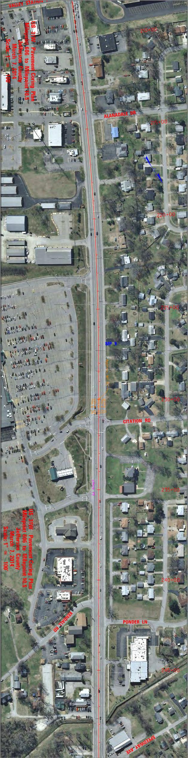
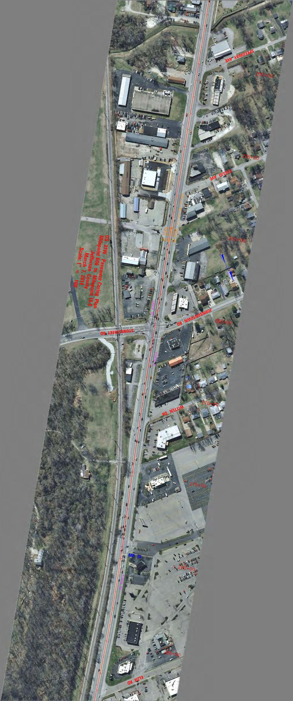
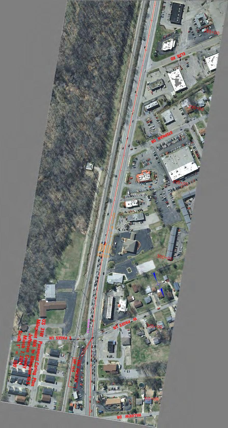
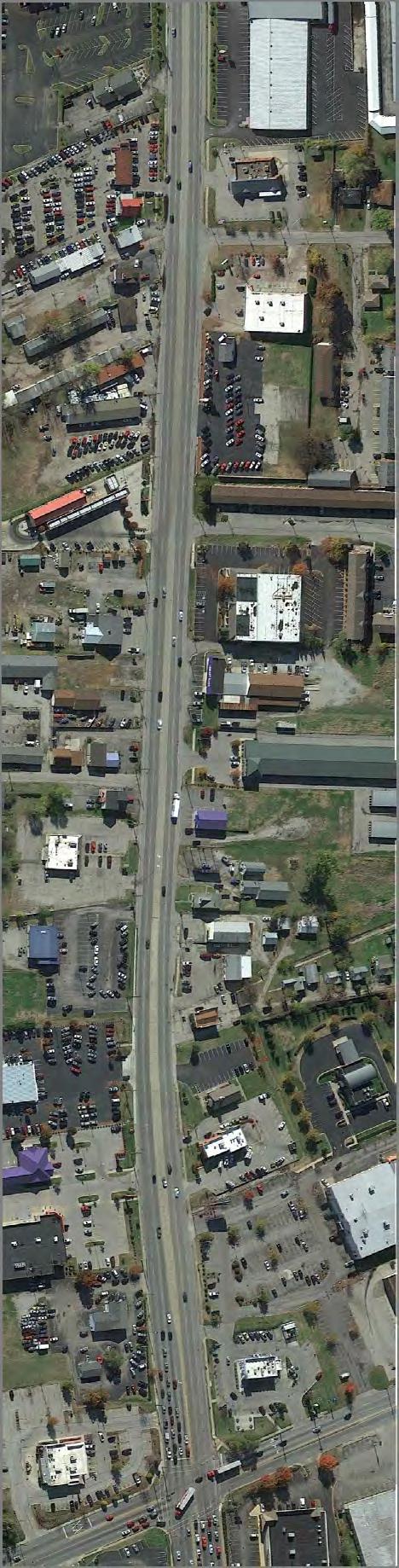
5 I. INTRODUCTION: The Kentucky Transportation Cabinet (KYTC) contracted the Kentucky Transportation Center (KTC) to provide a forensic investigation for the US 31W pavement rehabilitation project in Jefferson County otherwise known as Dixie Highway. The purpose of the pavement investigation was to determine the depths and type of the pavement structure/base aggregate through the length of the project. The following report contains the results of the pavement investigation from mileposts 6.6 to 11.7 for US 31W (approximate station numbers to ). II. METHODOLOGY: KTC utilized Ground Penetrating Radar (GPR) technology to determine the depths of the pavement along the route. Each lane was scanned along a single path using a 900 MHz antenna. The radar signal and the associated distance were recorded every one inch along the lane. The GPR path taken along the two northbound, two southbound, and the center turn lanes were preformed approximately in the center of each lane (see Diagram 1). Diagram 1: Radar Paths (n.t.s) 10 lane GPR Path CL of lane +/ middle turn lane GPR Path CL of lane +/ 1.0 Directional path for GPR (NB SB) Directional path for GPR Middle Turn Lane 1

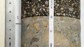
6 A total of five lanes were scanned for the project using GPR. All scans were performed in the lanes direction of normal travel except the middle turn lane. It was scanned in the northbound direction. The northbound scan direction started at pavement change at approximately station number and proceeded approximately 25,673 feet to the intersection of Greenwood and Dixie highway, approximate station number The lane designations are as follows (Diagram 2): 1. Northbound Right Lane: NBRL 2. Northbound Left Lane: NBLL 3. Northbound Middle Lane: NBML 4. Southbound Right Lane: SBRL 5. Southbound Left Lane: SBLL Diagram 2: Lanes Scanned with GPR After the data was collected calibration cores were taken in each lane. In-situ pavement thicknesses were measured and used for calibrating the data for the analysis. A total of seven cores were taken for calibration cores. The measurements are listed in Table 1 below. Table 1: GPR Calibration Core Measurements Lane Direction Station Number Asphalt (in.) Concrete (in.) DGA (in.) NB RL NB LL N/A NB LL N/A NB ML N/A 5.75 NB ML N/A 8.25 SB LL N/A SB LL N/A 2
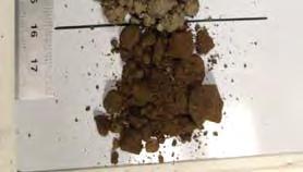
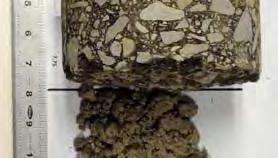
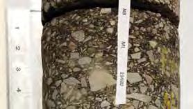
7 III. ANALYSIS: All data was post processed in the office. The bottoms of all visible pavement layer types were identified by hand within the analysis software. The pavement depth measurements from the cores were used to calibrate the depth measurements in the analysis software. All data was exported into Microsoft Excel to display in graph form and may be viewed in Appendix A. The actual data in spreadsheet form will be delivered to the design consultant for further analysis. IV. RESULTS: Each graph shows the pavement depth for a lane along a particular path (Appendix A). The horizontal axis references the mainline station number. The vertical axis is the depth measured in inches from the surface of the pavement to the bottom of the pavement layer type. The data depicted in Appendix A are averaged in Table Two below: Table 2: Average Layer determined by calibrated GPR Data: Lane Avg. Asphalt thickness Avg. Concrete thickness Avg. DGA thickness (in.) (in.) (in.) NBRL where applicable NBLL n/a NBML where applicable 6.14 SBLL n/a SBRL where applicable *where applicable: denoted on graphs in Appendix A Additional Pavement Observations: After review of all collected GPR data, it has been determined that approximately seventy-five (75) percent of the total pavement area has an apparent one (1) ft. by six (6) inch wire mesh used for structural reinforcement within the concrete pavement structure. Only the middle turn lane and the outer right-wheel-paths of the right lanes appeared to not have any wire mesh reinforcement within the pavement structure. Field Cores / Subgrade Conditions: Approximately seven cores were taken for the ground penetrating radar calibration process (Appendix B). In areas where asphalt was placed over concrete, the four to five one inch layers of asphalt appear to be surface overlay mixes and/or apparent 3/8 size mixes (field cores can be made available by request). The cores also give us some guidance as to how the different sections of roadway have been constructed. First, it appears that one-half of the outer most lanes are non-reinforced concrete pavement beneath an asphalt overlay. This non-reinforced concrete pavement has been placed predominately on a well compacted clay material. The aggregate within this concrete section appears to be crushed limestone. The inner half of these outer lanes towards the centerline of the roadway is comprised of a reinforced concrete pavement (wire-mesh) with an asphalt overlay. The aggregate within this half section of the outer lane towards the center-line appears to be very durable river rock. The inside lanes appear to be a reinforced concrete pavement (wire-mesh) with an asphalt overlay. Again this roadway section was placed on a well 3
8 compacted clay material, and the aggregate within the concrete appears to be a very durable river rock. Placing a concrete pavement upon a well compacted clay subgrade was standard practice until mid-1950 per previous highway specifications manuals. The last type of pavement section discovered on the studied area appears in the center turn lane. As shown in Appendix A/B this lane is predominately an asphalt pavement over compacted DGA. Additional pavement core information may be found in Appendix C which was collected by others. V. CONCLUSION AND RECOMMENDATIONS: The integrity of the underlying concrete pavement beneath the asphalt pavement appears to be competent and structurally sound. The clay soil beneath the concrete pavement appears relatively dry and well compacted. However, reflective cracking of the concrete joints do appear in the upper asphalt paving surface throughout the project. Provided that this section of roadway has many at-grade entrances and some curb-and-gutter, it is of opinion that there are three options for a pavement repair that could be considered to meet the elevations of the existing curb-and-gutter and entrances: 1. Mill the existing asphalt down to the old concrete and replace with new asphalt. 2. Mill the existing asphalt down to the old concrete and break and seat the old concrete and replace the surface with either concrete or asphalt. 3. Remove all pavement material, stabilize sub-grade, and rebuild complete pavement structure. 4
9 Appendix A 5
10 US 31W Jefferson County Pavement Block Depths North Bound Right Lane Station (ft.) Depth (in.) Bottom of Asphalt Bottom of Concrete Bottom of DGA
11 US 31W Jefferson County Pavement Block Depths North Bound Left Lane Station (ft.) Depth (in.) Bottom of Asphalt Bottom of Concrete
12 US 31W Jefferson County Pavement Block Depths Middle Lane Station (ft.) Raised Median/Bridge Pier Depth (in.) Bottom of Asphalt Bottom of Concrete Bottom of DGA
13 US 31W Jefferson County Pavement Block Depths South Bound Left Lane Station (ft.) Depth (in.) Bottom of Asphalt Bottom of Concrete
14 US 31W Jefferson County Pavement Block Depths South Bound Right Lane Station (ft.) Depth (in.) Bottom of Asphalt Bottom of Concrete Bottom of DGA
15 Appendix B 11
16
17
18


19


20
21
22 Appendix C 18
23 US 31W Pavement Core Hole Locations Milepoint 6.6 to Milepoint 10.5 Jefferson County Hole No. Approx. Milepoint Station Offset Direction Offset Distance (ft) Descrption of Location Asphalt Concrete Left 33 On Outside Shoulder 5 3/ Left 22 Center Outside Lane 7 7/8 6 7/ At CL 0 Center Flush Median Right 22 Center Outside Lane 7 7/8 6 7/ Right 33 On Outside Shoulder 4 1/ Left 33 On Outside Shoulder 6 1/ Left 23 Center Outside Lane 5 6 3/ At CL 0 Center Flush Median 8 1/ Right 38 Center Outside Lane 11 1/ Right 48 On Outside Shoulder Left 40 On Outside Shoulder Left 28 Center Outside Lane 6 8 1/ Right 4 Center Left Turn Lane Right 28 Center Outside Lane 5 3/4 8 1/ Right 40 On Outside Shoulder 6 3/ Left 32 On Outside Shoulder Left 22 Center Outside Lane 4 3/4 6 3/ At CL 0 Center Flush Median 7 1/ Right 22 Center Outside Lane 6 6 7/ Right 32 On Outside Shoulder 5 1/ Left 32 On Outside Shoulder Left 22 Center Outside Lane At CL 0 Center Left Turn Lane 7 1/ Right 22 Center Outside Lane 5 6 1/ Right 32 Center Right Turn Lane 6 3/ Left 34 On Outside Shoulder 4 1/ Left 22 Center Outside Lane 4 3/4 6 3/ At CL 0 Center Flush Median 7 1/ Right 22 Center Outside Lane Right 32 On Outside Shoulder 8 1/ Left 34 On Outside Shoulder 6 3/ Left 22 Center Outside Lane 4 1/ At CL 0 Center Flush Median 6 5/ Right 20 Center Outside Lane 5 3/ Right 30 On Outside Shoulder 4
24 The following pavement core holes are in turn lanes or I-265 ramp tapers along the Hole No. Approx. Milepoint Station Offset Direction Offset Distance (ft) Descrption of Location Asphalt Concrete Right 35 Center Right Turn Lane 5 7/ Left 50 On Outside Shoulder 6 1/ Left 38 In Ramp Taper 6 1/2 7 3/ Left 52 On Outside Shoulder 8 1/ Left 40 In Ramp Taper 6 3/4 8 3/ Left 46 On Outside Shoulder 6 3/ Left 36 In Ramp Taper 6 1/2 7 1/ Left 32 Center Right Turn Lane 8 1/ Right 32 Center Right Turn Lane Right 32 Center Right Turn Lane Left 32 Center Right Turn Lane 4 3/ Right 32 Center Right Turn Lane Right 32 Center Right Turn Lane Right 32 Center Right Turn Lane Right 32 Center Right Turn Lane Left 34 Center Right Turn Lane 8 1/ Left 32 Center Right Turn Lane Right 32 Center Right Turn Lane 7.5
The Use and Performance of Geogrids in Kentucky
 Transportation Kentucky Transportation Center Research Report University of Kentucky Year 2003 The Use and Performance of Geogrids in Kentucky Aric Cowne Richard Reitenour David L. Allen R. Clark Graves
KENTUCKY TRANSPORTATION CENTER
 Research Report KTC-08-28/FR165-07-1F KENTUCKY TRANSPORTATION CENTER MONITORING CULVERT LOAD WITH SHALLOW FILLING UNDER GEOFOAM AREAS OUR MISSION We provide services to the transportation community through
ENTUCKY RANSPORTATION C ENTER. College of Engineering
 Research Report KTC-05-34/SPR-297-05-1I T K ENTUCKY RANSPORTATION C ENTER College of Engineering USE OF ULTRA-LIGHTWEIGHT GEOFOAM TO REDUCE STRESSES IN HIGHWAY CULVERT EXTENSIONS Our Mission We provide
Performance of Ultra-Thin Bounded Wearing Course (UTBWC) Surface Treatment on US-169 Princeton, Minnesota. Transportation Research
 Surface Treatment on US-169 Princeton, Minnesota. Transportation Research") 2007-18 Performance of Ultra-Thin Bounded Wearing Course (UTBWC) Surface Treatment on US-169 Princeton, Minnesota Take the steps... Research...Knowledge...Innovative Solutions! Transportation Research
2007-18 Performance of Ultra-Thin Bounded Wearing Course (UTBWC) Surface Treatment on US-169 Princeton, Minnesota Take the steps... Research...Knowledge...Innovative Solutions! Transportation Research
Appendix B Existing ADOT Data Parameters
 Appendix B Existing ADOT Data Parameters Appendix 08/04/03 HPMS by Item Number All records 1 Year of Submittal 2 State Code 3 English or Metric Reporting Units 4 County Code 5 Section Identification (ID)
Evaluation of Construction-Zone Pavement Marking Materials
 Transportation Kentucky Transportation Center Research Report University of Kentucky Year 1987 Evaluation of Construction-Zone Pavement Marking Materials Kenneth R. Agent Jerry G. Pigman University of
Study of the Effects of Buried Pipe Integrity on Roadway Subsidence
 Pipe-RU6558 Study of the Effects of Buried Pipe Integrity on Roadway Subsidence FINAL REPORT October 2005 Submitted by Dr. Husam Najm * Professor Dr. Ali Maher * Professor/Director Dr. Nenad Gucunski *
MNDOT PAVEMENT DESIGN MANUAL
 MNDOT PAVEMENT DESIGN MANUAL Chapter 6 Ramps, Shoulders, Turn Lanes & Miscellaneous Pavements MnDOT Pavement Engineer Date Contents Introduction... 1 600 Ramps and Loops... 1 610 - Shoulders... 2 620 -
Paul Huston, P.E., Design-Build Coordinator Chuck Gonderinger, HDR Engineering. Minnesota Department of Transportation (the Department)
") To: From: Paul Huston, P.E., Design-Build Coordinator Chuck Gonderinger, HDR Engineering Date: March 20, 2001 Subject: Roadway Geometric Design Criteria Project: TH 14/218 Design-Build Project, SP 7408-29,
To: From: Paul Huston, P.E., Design-Build Coordinator Chuck Gonderinger, HDR Engineering Date: March 20, 2001 Subject: Roadway Geometric Design Criteria Project: TH 14/218 Design-Build Project, SP 7408-29,
WYDOT DESIGN GUIDES. Guide for. Non-NHS State Highways
 WYDOT DESIGN GUIDES Guide for Non-NHS State Highways 2014 GUIDE FOR Non-NATIONAL HIGHWAY SYSTEM (Non-NHS) STATE HIGHWAYS PRESERVATION REHABILITATION RECONSTRUCTION INTRODUCTION This Guide is directed to
Driveway Design Criteria
 Design Manual Chapter 5 - Roadway Design 5L - Access Management 5L-4 Driveway Design Criteria A. General For efficient and safe operations, access drives and minor public street intersections can be improved
Use of Roller Compacted Concrete By GDOT. Presented By: Joe W. Sheffield, PE Georgia Department of Transportation District Engineer, Tifton, GA
 Use of Roller Compacted Concrete By GDOT Presented By: Joe W. Sheffield, PE Georgia Department of Transportation District Engineer, Tifton, GA First Use of RCC By Georgia DOT I-285 Atlanta, GA 2005 Traffic:
WYDOT DESIGN GUIDES. Guide for. NHS Arterial (Non-Interstate)
") WYDOT DESIGN GUIDES Guide for NHS Arterial (Non-Interstate) 2014 GUIDE FOR NATIONAL HIGHWAY SYSTEM (NHS) HIGHWAYS (NHS ARTERIALS, Non-Interstate) PRESERVATION REHABILITATION RECONSTRUCTION INTRODUCTION
WYDOT DESIGN GUIDES Guide for NHS Arterial (Non-Interstate) 2014 GUIDE FOR NATIONAL HIGHWAY SYSTEM (NHS) HIGHWAYS (NHS ARTERIALS, Non-Interstate) PRESERVATION REHABILITATION RECONSTRUCTION INTRODUCTION
State of Nevada Department of Transportation Materials Division
 State of Nevada Department of Transportation Materials Division METHOD OF TEST FOR EVALUATION OF PAVEMENT RIDE QUALITY USING INERTIAL PROFILING SYSTEMS SCOPE This test method describes the procedure used
APPENDIX D COST SUMMARY TABLES
 APPENDIX D COST SUMMARY TABLES Section 1 Between Route 50 and Evergreen Mills Road 3850 linear feet of one 12 foot wide additional lane in southbound direction of Rte 606; from north side of Rte 50 to
PENNDOT HPMS DATA COLLECTION GUIDE. Bureau of Planning and Research Transportation Planning Division April 2016 (Updated March 2018)
") PENNDOT HPMS DATA COLLECTION GUIDE Bureau of Planning and Research April 2016 (Updated March 2018) State Street Dauphin County NOTES INTRODUCTION The purpose of this document is to provide you with some
PENNDOT HPMS DATA COLLECTION GUIDE Bureau of Planning and Research April 2016 (Updated March 2018) State Street Dauphin County NOTES INTRODUCTION The purpose of this document is to provide you with some
CITY OF WEST LAKE HILLS. Forest View Neighborhood Traffic Calming Study
 CITY OF WEST LAKE HILLS 901 South Mopac Expressway Building V, Suite 220 Austin, Texas 78746 Texas P.E. Firm Registration No. F-929 Klotz Associates Final Report Submittal: March 20, 2015 Revised Final
SECTION 48 - TRAFFIC STRIPES AND PAVEMENT MARKINGS TABLE OF CONTENTS
 SECTION 48 - TRAFFIC STRIPES AND PAVEMENT MARKINGS TABLE OF CONTENTS Section Page 48-1 GENERAL...48.1 48-2 THERMOPLASTIC TRAFFIC STRIPES AND PAVEMENT MARKINGS...48.1 48-3 PAINTED TRAFFIC STRIPES AND PAVEMENT
Pavement and Asset Management from a City s Perspective Mike Rief, PE, DBIA and Andrea Azary, EIT. February 12, 2015
 Pavement and Asset Management from a City s Perspective Mike Rief, PE, DBIA and Andrea Azary, EIT February 12, 2015 What is Pavement Management? At a Network Level: Pavement management refers to a systematic
Paul Vraney Bureau of Project Development 02/11/2016
 Paul Vraney Bureau of Project Development 02/11/2016 ADA background & alterations definition Design considerations Provide sufficient layout data Curb ramp selection Maximum curb ramp and gutter slopes
PENNDOT HPMS DATA COLLECTION GUIDE
 PENNDOT HPMS DATA COLLECTION GUIDE Bureau of Planning and Research April 2016 (Updated September 2017) State Street Dauphin County INTRODUCTION The purpose of this document is to provide you with some
SECTION 48 - TRAFFIC STRIPES AND PAVEMENT MARKINGS TABLE OF CONTENTS
 SECTION 48 - TRAFFIC STRIPES AND PAVEMENT MARKINGS TABLE OF CONTENTS Section Page 48-1 GENERAL... 48.1 48-2 THERMOPLASTIC TRAFFIC STRIPES AND PAVEMENT MARKINGS... 48.1 48-3 PAINTED TRAFFIC STRIPES AND
Lf Wv-11 L_ Mario Dupigny-G iroux, P.E. Traffic Safety Engineer. ja WTtffiti. _J~?feL. \~tk 1pp Research Technician
 Activated Approach Flasher System Final Report October 2009 Report 2009-11 Reporting on Work Plan No. W P 2006-R-1 State of Vermont Agency of Transportation Materials and Research Section Prepared by:
County of Sacramento Standard Construction Specifications January 1, 2008 TECHNICAL PROVISIONS
 County of Sacramento Standard Construction Specifications January 1, 2008 TECHNICAL PROVISIONS SECTION 48 TRAFFIC STRIPES AND PAVEMENT MARKINGS 48-1 GENERAL Traffic stripes and pavement markings shall
Tacoma Streets 101. City of Tacoma - Citizen Neighborhood Street Improvement and Safety Task Force
 1 Tacoma Streets 101 2 Streets Maintenance Overview Type and amount of streets Condition and types of construction Maintenance and repair methods and costs Sample Project Philosophy/Selection Criteria
FOR LOOP RAMPS-TAPERED DECELERATION LANE
 6" WHITE DOTTED LINE: 5 MARK, 20 SKIP 6" WHITE CRYSTAL MONO-DIRECTIONAL MAIN LINE END (EVERY 50 FEET) 50 FEET BEYOND LAST CRYSTAL PAVEMENT MARKER 5 AMBER MONO-DIRECTIONAL 50 FEET BEFORE LAST CRYSTAL PAVEMENT
Access requests to County streets and roadways are processed through one of the following methods:
 13.1 GENERAL APPLICATION PROCESS Access requests to County streets and roadways are processed through one of the following methods: A. Planned Developments may set general locations for access points.
SECTION 1A NEW JERSEY TURNPIKE GEOMETRIC DESIGN
 SECTION 1A NEW JERSEY TURNPIKE GEOMETRIC DESIGN Table of Contents Page No 1A.1 GENERAL...1 1A.1.1 DESIGN CONTROLS...1 1A.2 MAINLINE ROADWAYS...4 1A.2.1 ROADWAY DESIGNATION...4 1A.2.2 DESIGN SPEED...4 1A.2.3
CHAPTER 1 STANDARD PRACTICES
 CHAPTER 1 STANDARD PRACTICES OBJECTIVES 1) Functions and Limitations 2) Standardization of Application 3) Materials 4) Colors 5) Widths and Patterns of Longitudinal Pavement Marking Lines 6) General Principles
2010 STANDARD SPECIFICATIONS STANDARD DRAWINGS
 CITY OF REDMOND, OREGON 2010 STANDARD SPECIFICATIONS STANDARD DRAWINGS TABLE OF CONTENTS SECTION 1 TRENCHES TITLE 1-1 Utility Trench 1-2 Water Line & Sewer Line Separation 1-3 RR X-ING Single/Joint Use
Field guide for Accessible Public Rights-of-Way Edition
 Field guide for Accessible Public Rights-of-Way 2015 Edition BRIEFING MEMO SUBJECT: Department of Justice/Department of Transportation Joint Technical Assistance on Title II of the Americans with Disabilities
Design Criteria. Design Criteria
 F Design Criteria Design Criteria Ministry of Transportation Ministère des Transports DESIGN CRITERIA Page: 1 of 13 WORK PROJECT NO. N/A GO Bloomington Station TYPE OF PROJECT LOCATION Bloomington Road
Evaluation of the Wisconsin DOT Walking Profiler
 Final Report Evaluation of the Wisconsin DOT Walking Profiler March 2007 U.S. Department of Transportation Federal Highway Administration Notice This document is disseminated under the sponsorship of the
Fleur Drive Reconstruction
 Fleur Drive Reconstruction October 29, 2018 1 Agenda: Fleur Drive Reconstruction Project Scope & Cost Overview Fleur Drive Cross Section Elements - Travel Lane Widths - Sidewalk Widths - Parkway Widths
GUIDELINES FOR USING DECISION SIGHT DISTANCE AT IGNALIZED INTERSECTIONS NEAR VERTICAL CURVES
 1. Report No. FHWA/TX-05/0-4084-P2 4. Title and Subtitle 2. Government Accession No. 3. Recipient's Catalog No. GUIDELINES FOR USING DECISION SIGHT DISTANCE AT IGNALIZED INTERSECTIONS NEAR VERTICAL CURVES
PROJECT NO. 093 MA 199 H C. FEDERAL NO. xxxx WIKIEUP-WICKENBURG-PHOENIX HIGHWAY TEGNER STREET, ALTERNATIVE 10 PROJECT IMPROVEMENT
 PROJECT NO. 093 MA 199 H 5807 01C FEDERAL NO. xxxx WIKIEUP-WICKENBURG-PHOENI HIGHWAY TEGNER STREET, ALTERNATIVE 10 PROJECT IMPROVEMENT (INTERSECTION IMPROVEMENT) US 93/US 60 FINAL PROJECT ASSESSMENT April
FLORIDA DEPARTMENT OF TRANSPORTATION
 FLORIDA DEPARTMENT OF TRANSPORTATION FLEXIBLE PAVEMENT CONDITION SURVEY HANDBOOK March 2012 STATE MATERIALS OFFICE Table of Contents Title Page List of Tables... i List of Figures... ii Executive Summary...
East Downtown Tax Increment Reinvestment Zone (TIRZ) No. 15 Infrastructure Assessment Study
 No. 15 Infrastructure Assessment Study") East Downtown Tax Increment Reinvestment Zone (TIRZ) No. 15 Infrastructure Assessment Study Houston, TX Technical Memorandum April 15 th, 2009 Prepare by: 2950 North Loop West, Ste. 900 Houston, TX 77092
East Downtown Tax Increment Reinvestment Zone (TIRZ) No. 15 Infrastructure Assessment Study Houston, TX Technical Memorandum April 15 th, 2009 Prepare by: 2950 North Loop West, Ste. 900 Houston, TX 77092
General References Definitions. (1) Design Guidance. (2) Supporting Information
 Design Guidance. (2) Supporting Information") Chapter 1240 Turning Roadways 1240.01 General 1240.02 References 1240.03 Definitions 1240.04 Turning Roadway Widths 1240.05 Documentation 1240.01 General The roadway on a curve may need to be widened to
Chapter 1240 Turning Roadways 1240.01 General 1240.02 References 1240.03 Definitions 1240.04 Turning Roadway Widths 1240.05 Documentation 1240.01 General The roadway on a curve may need to be widened to
City/ Town: Route: Intersection Name; Street Names:
 City/ Town: Route: Intersection Name; Street Names: RAMP AND LEVEL LANDING Blank Identify Ramp Type (From Sketches If not identifiable, sketch Ramp.) 2 Is vertical curb blocking path of travel (Y/N) If
Chapter 5 DATA COLLECTION FOR TRANSPORTATION SAFETY STUDIES
 Chapter 5 DATA COLLECTION FOR TRANSPORTATION SAFETY STUDIES 5.1 PURPOSE (1) The purpose of the Traffic Safety Studies chapter is to provide guidance on the data collection requirements for conducting a
S.R. 3009, Section A20 South Park & Logan Road Intersection Improvement Project
 Open House Public Meeting S.R. 3009, Section A20 South Park & Logan Road Intersection Improvement Project Municipality of Bethel Park, Allegheny County Bethel Park Municipal Building 5001 West Library
Five Years Later. Illinois Asphalt Pavement Association Annual Meeting March 9, William J. Pine, P.E. Emulsicoat, Inc. / Heritage Research
 I-70 Five Years Later Illinois Asphalt Pavement Association Annual Meeting March 9, 2009 William J. Pine, P.E. Emulsicoat, Inc. / Heritage Research Joint Venture: Howell Asphalt/Paving Champaign Asphalt
Evaluation of Pavement Marking Performance
 Transportation Kentucky Transportation Center Research Report University of Kentucky Year 2008 Evaluation of Pavement Marking Performance Eric R. Green Kenneth R. Agent University of Kentucky, eric.green@uky.edu
SECTION 3 STREET DESIGN
 3.01 GENERAL SECTION 3 STREET DESIGN For purposes of geometric and structural design, streets shall be classified according to the following table. The City Engineer will determine the class of all proposed
Evaluation of M-99 (Broad Street) Road Diet and Intersection Operational Investigation
 Road Diet and Intersection Operational Investigation") Evaluation of M-99 (Broad Street) Road Diet and Intersection Operational Investigation City of Hillsdale, Hillsdale County, Michigan June 16, 2016 Final Report Prepared for City of Hillsdale 97 North Broad
Evaluation of M-99 (Broad Street) Road Diet and Intersection Operational Investigation City of Hillsdale, Hillsdale County, Michigan June 16, 2016 Final Report Prepared for City of Hillsdale 97 North Broad
Description: Widen I-64 to 6 lanes from I-265 to the KY 53 interchange in Shelby County.
 I-64 KIPDA ID # 350 Project Type: ROADWAY CAPACITY Description: Widen I-64 to 6 lanes from I-265 to the KY 53 interchange in Shelby County. Purpose: Project will improve capacity and address safety concerns.
Emerging Concrete Pavement Solutions Roller Compacted Concrete (RCC)
") Emerging Concrete Pavement Solutions Roller Compacted Concrete (RCC) Presented to: APWA Nor Cal November 3 rd, 2016 Presenters: Jason Shykowsi, P.E., T.E. City of Roseville Debbie Haldeman RCC Council
Emerging Concrete Pavement Solutions Roller Compacted Concrete (RCC) Presented to: APWA Nor Cal November 3 rd, 2016 Presenters: Jason Shykowsi, P.E., T.E. City of Roseville Debbie Haldeman RCC Council
ENTUCKY RANSPORTATION ENTER
 ResearchReport KTC-01-16/FH-94-3F T K ENTUCKY RANSPORTATION C ENTER CollegeofEngineering EVALUATION OF REFERENCE MARKERS(FINAL REPORT) UNIVERSITYOFKENTUCKY University of Kentucky College of Engineering
PLACEMENT OF SIGNS RECOMMENDED PRACTICES SUB-SECTION
 Page 1 of 6 RECOMMENDED PRACTICES PART SECTION SUB-SECTION HIGHWAY SIGNS GENERAL General Proper positioning of signs is an important element in the overall control of traffic within a roadway network.
Introduction to Roadway Design
 Chapter Introduction to Roadway Design 1 This chapter lays the foundation for the Roadway Design course. You examine the roadway design workflow and the completed drawing files and review the project scope,
GEOMETRIC DESIGN STANDARDS FOR NEW RESIDENTIAL SUBDIVISION STREETS TABLE 1A CG-6 CURB AND GUTTER SECTION
 TABLE 1A CG-6 CURB AND GUTTER SECTION HORIZONTAL AND VERTICAL CONTROLS CURB AND GUTTER ROADWAYS MAXIMUM 3:1 CUT OR FILL SLOPE CURVE DATA MIN. SIGHT DISTANCE PROJECTED TRAFFIC VOLUME (ADT) MIN. DESIGN SPEED
HIR on Oklahoma Turnpikes
 HIR on Oklahoma Turnpikes Tammy Robinson, P.E., Division Engineer EST, Inc. Stephen A. Cross, PhD, PE Professor, Oklahoma State Executive Director Pavement Recycling & Reclaiming Center HIR on Oklahoma
CTH M HIGHWAY PROJECT CTH Q to STH 113
 CTH M HIGHWAY PROJECT CTH Q to STH 113 PUBLIC INFORMATIONAL MEETING #3 Wednesday, May 25, 2005 Town of Westport Administration Building 5387 Mary Lake Road 6:00 p.m. to 8:00 p.m. PUBLIC INFORMATIONAL MEETING
Summary of Findings Concerning Longitudinal Cracking on 16' Wide Ramps
 Summary of Findings Concerning Longitudinal Cracking on 16' Wide Ramps Office of Pavement Engineering October 14, 2003 Abstract: This paper summarizes the current practice in ODOT regarding the construction
Bids MAY 24, 2018 AT 2:00 P.M. (EASTERN) (Estimated Cost: $7,500,000.00)
 (Estimated Cost: $7,500,000.00)") General Info Number: PROJECT NO. 43-18-02 Description: BRIDGE DECK REPAIR AND REHABILITATION PERRYSBURG-HOLLAND ROAD OVER THE OHIO TURNPIKE, M.P. 59.0 HESSVILLE ROAD OVER THE OHIO TURNPIKE, M.P. 84.4 LUCAS
General Info Number: PROJECT NO. 43-18-02 Description: BRIDGE DECK REPAIR AND REHABILITATION PERRYSBURG-HOLLAND ROAD OVER THE OHIO TURNPIKE, M.P. 59.0 HESSVILLE ROAD OVER THE OHIO TURNPIKE, M.P. 84.4 LUCAS
Legislative Update Williamsburg Residency
 Hampton Roads District Legislative Update Williamsburg Residency Jim Brewer, Resident Administrator 757-253-5140 Projects Under Way Warwick Boulevard Project http://www.warwickboulevard.org/ Contractors:
TRAFFIC ACCIDENT ANALYSIS
 TRAFFIC ACCIDENT ANALYSIS Westheimer at Chimney Rock and Westheimer at Dunvale Prepared for Prepared by Klotz Associates, Inc. 1160 Dairy Ashford, Suite 500 Houston, Texas 77079 The preparation of this
Roadway Design Manual
 Roadway Design Manual Manual Notice Archive by Texas Department of Transportation (512) 302-2453 all rights reserved Manual Notice 2009-1 From: Manual: Mark A. Marek, P.E Roadway Design Manual Effective
Specifier Note: Retain or delete material(s) below to conform to project requirements.
 below to conform to project requirements.") SECTION 32 15 40 DECOMPOSED GRANITE SURFACING NOTE: These specifications were current at the time of publication but are subject to change at any time without notice. Please confirm the accuracy of these
SECTION 32 15 40 DECOMPOSED GRANITE SURFACING NOTE: These specifications were current at the time of publication but are subject to change at any time without notice. Please confirm the accuracy of these
KDOT Access Management Policy (AMP)
") KDOT Access Management Policy (AMP) (January 2013 Edition) Errata KDOT intends to correct these errors during the next revision to the Policy. Corrections are denoted in red text with a solid line through
KDOT Access Management Policy (AMP) (January 2013 Edition) Errata KDOT intends to correct these errors during the next revision to the Policy. Corrections are denoted in red text with a solid line through
NEW JERSEY DEPARTMENT OF TRANSPORTATION RIDE QUALITY SPECIFICATION AND CASE STUDIES
 NEW JERSEY DEPARTMENT OF TRANSPORTATION RIDE QUALITY SPECIFICATION AND CASE STUDIES BY NARINDER S. KOHLI, P.E. PRINCIPAL ENGINEER PAVEMENT DESIGN, NJDOT (609) 530 8140 NARINDER.KOHLI@DOT.STATE.NJ.US RIDE
FOR HISTORICAL REFERENCE ONLY
 To: From: Subject: Electronic Distribution Recipients MINNESOTA DEPARTMENT OF TRANSPORTATION Engineering Services Division Technical Memorandum No. 12-14-B-03 December 18, 2012 Jon M. Chiglo, P.E. Division
Update on Performance of Thin Asphalt Overlays
 Update on Performance of Thin Asphalt Overlays Pennsylvania Asphalt Pavement Association 55 th Annual Conference Mansour Solaimanian Penn State University 1 Outline Thin Asphalt Overlay Pilot Projects
IN-PLACE DENSITY OF BITUMINOUS MIXES USING THE NUCLEAR MOISTURE-DENSITY GAUGE FOP FOR WAQTC TM 8
 OF BITUMINOUS MIXES USING THE NUCLEAR MOISTURE-DENSITY GAUGE FOP FOR WAQTC TM 8 Scope This test method describes a test procedure for determining the density of bituminous mixes by means of a nuclear gauge
Lake Waterford Community Association Meeting. November 15, 2016
 Lake Waterford Community Association Meeting November 15, 2016 Introduction Staff Introduction Project Overviews - Completed Projects - Pavement Management Program - Pasadena Road Sidewalk Improvements
Update to DOTD Roundabout Design Policy
 Update to DOTD Roundabout Design Policy Roundabout In Louisiana Louisiana has 18 roundabouts in operation and 53 proposed History EDSM s or Engineering Directives and Standards set DOTD policies, procedures,
Downloaded from Downloaded from /1
 VI SEMESTER FINAL EXAMINATION-2003 Q. [1] [a] Draw a right angle four-arm intersection of two roads and show various conflicts points if [a] both roads are with way movements, and [b] one road is with
APPENDIX L: COST ESTIMATING TOOLS
 APPENDIX L: COST ESTIMATING TOOLS Rural Arterial From LRE MOT * Mobilization * Subtotal Scope Contingency (25%) Total PE Design (15%) CEI (15%) Total Project ** New (2-Lane Roadway) with 5' Paved Shoulders
Advantages & Specifications for the Use of Perma-Patch for the Repair of Potholes
 Advantages & Specifications for the Use of Perma-Patch for the Repair of Potholes The Pothole Solution... p.2 Specifications... p.3 Using Perma-Patch in Severe Weather... p.4 www.permapatch.com Frequently
September Reporting on Work Plan 95-R-15 Final Report. Prepared by: Reviewed by:
 Recessed Thermoplastic Pavement Markings Montpelier, Vermont September 2002 Reporting on Work Plan 95-R-15 Final Report State of Vermont Agency oftransportation Materials and Research Prepared by: Theresa
50 Year Roads: Don't Accept Anything Less
 50 Year Roads: Don't Accept Anything Less Prepared By Thomas O. Malerk Director of Transportation Engineering Florida Concrete & Products Association NACE Annual Meeting April 22, 2015 Presented by Roger
ODOT construction cost is $51,000,000. State assumes and bears 100 percent of the cost of improvement.
 1. I 271 WIDENING & RESURFACING - PID 89458 Project consists of major reconstruction, widening and bridge deck replacement. Project will accomplish widening from 4 to 6 lanes, including redecking and widening
Rock Chalk Park-Pavement Corings Lawrence, Kansas
 850 E. 13th Street Ste. B (785) 856-9600 Office cfse.com Other Offices: Topeka, Kansas Kansas City, Kansas Wichita, Kansas Kansas City, Missouri Branson, Missouri Springfield, Missouri August 29, 2014
CHAPTER 8 STAKING SIGNALS AND LIGHTING FIELD GUIDE. 8.1 Staking Traffic Control Signal Systems
 CHAPTER 8 STAKING STAKING Correct staking of traffic control signal or lighting systems is critical to the appropriate placement of system components. 8.1 Traffic Control Signal Systems Locating the components
"Emul Asph (SS-1HP) Tack".
 Tack.") Page 1 of 25 Application of Emulsified Asphalt, (fog seal 2-lane section). Using a distributor, uniformly apply fog seal to the rumble strip with two passes of the distributor, one in each direction of
Page 1 of 25 Application of Emulsified Asphalt, (fog seal 2-lane section). Using a distributor, uniformly apply fog seal to the rumble strip with two passes of the distributor, one in each direction of
FAIRWAY PALMS II CONDOMINIUM PROPERTY
 FAIRWAY PALMS II CONDOMINIUM PROPERTY 6533, through 6553 SE Federal HWY, Stuart Florida, 34997. Structural Inspection Report Prepared by CA 26583 Ph: 561-204-5000 Fax: 561-204-1050 E-mail: aali@universalengineering.net
Replace Bridge 51 on Blackiston Mill Dr. over Silver Creek,
 INDIANA PROJECTS 1558 Bridge 51 1601823 1601971 I 64 Blackiston Mill Road Phase II Charlestown Rd. Clark State Forest Road Maintenance E. Main Street Improvements to Blackiston Mill Road from just north
Evaluating the Design Safety of Highway Structural Supports
 Evaluating the Design Safety of Highway Structural Supports by Fouad H. Fouad and Elizabeth A. Calvert Department of Civil and Environmental Engineering The University of Alabama at Birmingham Birmingham,
A Comprehensive HCM 2010 Urban Streets Analysis Using HCS 2010 US 31W in Elizabethtown, KY
 A Comprehensive HCM 2010 Urban Streets Analysis Using HCS 2010 US 31W in Elizabethtown, KY Ashley McLain, PE, PTOE Abstract The HCS 2010 Streets module was used to analyze a segment of the US 31W corridor
General Notes. Project No /15/2018 Page 1 of 1
 5081 Page 1 of 13 General Notes 5/15/2018 Page 1 of 1 Project No. 82 183-82 KA D 5081-01 0309-19 1 2 Note The contractor is responsible for establishing and maintaining centerline of the traveled way for
Analysis of Run-Off-Road Crashes in Relation to Roadway Features and Driver Behavior
 Analysis of Run-Off-Road Crashes in Relation to Roadway Features and Driver Behavior Ertan Örnek University of Wisconsin, Madison Traffic Operations Lab 141 NW Barstow Street Waukesha, WI 53187 ornek@wisc.edu
SECTION [ ] [02730] STABILIZED DECOMPOSED GRANITE SURFACING
![SECTION [ ] [02730] STABILIZED DECOMPOSED GRANITE SURFACING](/thumbs/74/71116705.jpg "SECTION [ ] [02730] STABILIZED DECOMPOSED GRANITE SURFACING") SECTION [32 15 40] [02730] STABILIZED DECOMPOSED GRANITE SURFACING EDIT SPECIFICATION: Edit the following guide specification to comply with project requirements. This document is available in word processing
SECTION [32 15 40] [02730] STABILIZED DECOMPOSED GRANITE SURFACING EDIT SPECIFICATION: Edit the following guide specification to comply with project requirements. This document is available in word processing
Illini Union Champaign, IL. February 24, Paul Lorton, P.E. Safety Programs Unit Chief IDOT, Division of Highways, Bureau of Safety Engineering
 Illini Union Champaign, IL February 24, 2015 Paul Lorton, P.E. Safety Programs Unit Chief IDOT, Division of Highways, Bureau of Safety Engineering Temporary Concrete Barrier Pinning and Drop-off Policy
Field guide for Accessible Public Rights-of-Way Edition
 Field guide for Accessible Public Rights-of-Way 2017 Edition CONTENTS PEDESTRIAN FACILITIES IN THE PUBLIC RIGHT-OF-WAY Pedestrian access routes 3 Components 3 Continuous width 3 Median and pedestrian refuge
ENGINEER S PRELIMINARY REPORT. for the #######-###### COLLISION
 ENGINEER S PRELIMINARY REPORT for the #######-###### COLLISION By: Lance E. Robson, P.E. October 3, 2005 1 INVESTIGATION OF THE #######-###### COLLISION ENGINEER S PRELIMINARY REPORT October 3, 2005 ---------------------------------------------------------------------------------------------------------------
STAKING TRAFFIC CONTROL SIGNAL SYSTEMS
 Locating the components of a traffic control signal is not an exact science; many factors influence the location of the components. These factors include: lane widths, radii, pedestrian curb ramp requirements,
DRAFT WSDOT PAVEMENT POLICY
 DRAFT WSDOT PAVEMENT POLICY JANUARY 2010 Washington State Department of Transportation Environmental and Engineering Programs Division State Materials Laboratory Pavements Division P.O. Box 47365 Olympia,
Standard Test Procedures Manual
 STP 240-20 Standard Test Procedures Manual Section: 1. SCOPE 1.1. Description This method describes the test used to evaluate the thickness and bearing capacity of the subbase and subgrade using the Dynamic
Bases, Ballasts, and Paving
 Sections Included In This Standard: 1.1 Paving and Surfacing 1.2 Protection of the Work 1.3 Repair of Pavement 1.4 Pavement Marking 1.1 PAVING AND SURFACING A. DESIGN REQUIREMENTS 1. Applicable Design
DRAFT. Corridor study. Honeysuckle Road. October Prepared for the City of Dothan, AL. Prepared by Gresham, Smith and Partners
 DRAFT Corridor study Honeysuckle Road October 2017 Prepared for the City of Dothan, AL Prepared by TABLE OF CONTENTS SECTION I... 1 STUDY SUMMARY... 1 INTRODUCTION... 1 CONCLUSIONS... 5 SECTION II... 7
BI-DIRECTIONALS FREE-ACCESS
 BI-DIRECTIONALS FREE-ACCESS Dimensions may vary depending on design vehicle and turning movements. See GEO-650-Series for addtional details. SPECIAL Special situations, i.e., See Notes 4 & 5 wide streets,
Rio Intersection Traffic Restrictions Begin Monday
 May 18, 2016 8 Rio Intersection Traffic Restrictions Begin Monday This special edition of the Route 29 Solutions e mail newsletter includes everything you need to know about the May 23 through September
City of Roseville Section 13 Design Standards. _Bikeways January 2016 SECTION 13 BIKEWAYS
 SECTION 13 BIKEWAYS 13-1 GENERAL The City of Roseville bikeway standards are designed to insure that transportation and recreational bikeways are constructed in a manner that would provide a safe and comfortable
DETECTABLE WARNING SURFACES SHALL BE PROVIDED AT THE FOLLOWING LOCATIONS ON PEDESTRIAN ACCESS ROUTES:
 GENERAL NOTES: CURB NOTES: 5'-0" MIN 5'-0" 5'-0" MIN 1. 2. THESE SHEETS ARE IN ACCORDANCE WITH THE AMERICANS WITH DISABILITIES ACT (ADA), AND THE REQUIREMENTS OF THE 2011 PROPOSED ACCESSIBILITY GUIDELINES
Introduction to Full Depth Asphalt Repairs. Setting Work Processes for a Quality Job Start in time to finish prior to Winter!
 Introduction to Full Depth Asphalt Repairs Setting Work Processes for a Quality Job Start in time to finish prior to Winter! Asphalt Pothole and Patching Repairs Smaller Repairs! Where do Potholes come
MAG Town of Cave Creek Bike Study Task 6 Executive Summary and Regional Significance Report
 Page 1 MAG Town of Cave Creek Bike Study Task 6 Executive Summary and Regional Significance Report August 1, 2012 MAG Project #481 Page 2 Task 6 Executive Summary and Regional Significance Report Introduction
An Overview of Mn/DOT s Pavement Condition Rating Procedures and Indices (March 27, 2003)
") An Overview of Mn/DOT s Pavement Condition Rating Procedures and Indices (March 27, 2003) Equipment Mn/DOT currently collects pavement condition data using a Pathway Services, Inc. Video Inspection Vehicle
An Overview of Mn/DOT s Pavement Condition Rating Procedures and Indices (March 27, 2003) Equipment Mn/DOT currently collects pavement condition data using a Pathway Services, Inc. Video Inspection Vehicle
2018 ROAD MAINTENANCE PROGRAM
 2018 ROAD MAINTENANCE PROGRAM John Tiger Anastasi Town of Bethlehem Superintendent of Highways June 27, 2018 AGENDA Why do we maintain our roads? How is the Road Maintenance Plan developed? The process
FINAL DESIGN TRAFFIC TECHNICAL MEMORANDUM
 FINAL DESIGN TRAFFIC TECHNICAL MEMORANDUM July 2014 FINAL (SR 43) Project Development and Environment Study From State Road 60 (Adamo Drive) to I-4 (SR 400) Hillsborough County, Florida Work Program Item