Overview of Traffic Safety in the Denver Region
|
|
|
- Frank Sims
- 6 years ago
- Views:
Transcription

1 Overview of Traffic Safety in the Denver Region June 2003 Denver Regional Council of Governments 4500 Cherry Creek Drive South, Suite 800 Denver, Colorado
2 This page intentionally left blank
3 ABSTRACT TITLE: AUTHOR: SUBJECT: Denver Regional Council of Governments (DRCOG) Traffic safety issues in the Denver region DATE: June 2003 SOURCE OF COPIES: STAFF INFORMATION CONTACT: Public Information and Communications Division DRCOG 4500 Cherry Creek Drive South Suite 800 Denver, CO Jennifer Edwards NUMBER OF PAGES: 43 ABSTRACT: This technical report is an overview of traffic safety issues in the DRCOG region. It presents data regarding the frequency, circumstances, and causes of traffic crashes in the region. The report describes numerous factors that influence traffic safety and discusses the role these factors play in planning for safety improvements. Typical techniques for reducing the likelihood and severity of crashes are described. The report lists sources of crash data and includes an inventory of traffic safety programs operating in the Denver region.
4 This page intentionally left blank
5 Table of Contents 1. Introduction 1 A. Purpose 1 B. Background 1 C. General Data 2 Crash Trends and Comparisons 3 Crash Causes 7 Crashes on Freeways 8 Crash Types 8 Crash Circumstances Regional Safety Issues 12 A. Transportation Facility Physical Issues 12 Real vs. Perceived Unsafe Locations 12 Signs and Signals 12 Pedestrian Interaction with Traffic 12 Bicycle Interaction with Traffic 13 Railroad Crossings 13 Rumble Strips 14 Shoulders 14 Drainage Grates 14 Traffic Calming 14 Winter Maintenance 14 Work Zone Safety 15 B. Driver Behavior, Enforcement, and Legislative Issues 15 Aggressive Driving and Road Rage 15 Distracted Driving 16 Enforcement of Laws Applying to Bicyclists 17 Impaired Driving 17 Older and Younger Drivers 17 Photo Enforcement of Speeding and Red Light Running 18 Safety Inspections 19 Seat Belts and Child Safety Seats 19 Sight Distance 20 C. Vehicle-related Issues 20 Commercial Vehicles 20 Motorcycles 21 SUVs 21 D. Emergency Response and Incident Management 21 District Cooperation 21 Incident Management 21 Roadway Design and Operation 22 Rural Crashes 22
6 3. Techniques for Reducing the Likelihood and Severity of Crashes 23 A. Engineering 23 Designing New Facilities 23 Improving Existing Facilities 23 Access Management 25 Intelligent Transportation Systems 25 B. Education 26 C. Enforcement 26 D. Emergency Response Inventory of Crash Data Sources 28 A. Data Sources 28 National Level 28 State Level 28 Local Level 29 B. Data Issues 29 Completeness and Timeliness of Data 29 Consistency of Data Reporting 30 Geographic Information Systems Next Steps for DRCOG 32 Appendices A. Traffic Safety Programs Available in the Denver Region 33 A. General Safety 34 B. Older Drivers 35 C. Younger Drivers 35 D. Impaired Driving 36 E. Occupant Safety 36 F. Aggressive Driving 37 G. Motorcycle Safety 37 H. Railroad and Transit Safety 37 I. Truck Safety 38 J. Bicycle Safety 38 K. Pedestrian Safety 39 L. Targeted Enforcement 39 B. Sample Crash Report and Citation 41
7 List of Tables Table 1. Reported Traffic Crashes by Municipality and County, DRCOG Region, Table 2. Annual Crashes and Vehicle Miles Traveled, DRCOG Region, 1991 to Table 3. Annual Traffic Safety Data Comparisons, Table 4. Types of Crashes, DRCOG Region, Table 5. Pedestrian and Bicyclist Involvement in Crashes, DRCOG Region, Table 6. Crash Circumstances, DRCOG Region, List of Figures Figure 1. Crashes, Injuries, and Fatalities in the DRCOG Region, Figure 2. Primary Cause of Reported Injury Crashes, Colorado, Figure 3. Crashes in 1999 on DRCOG Region Freeway Segments 9 Figure 4. National Fatality Rate by Age Group, Figure 5. Sample Intersection Diagram 24 Cover photo courtesy of James Mackay
8 This page intentionally left blank
9 1. Introduction A. Purpose This report presents an overview of traffic safety issues and data in the Denver region. It was prepared by the staff of the Denver Regional Council of Governments (DRCOG), the metropolitan planning agency for the nine-county Denver metropolitan region. The overall goal of traffic safety efforts at the regional, state, national, or local level is to reduce the likelihood or severity of traffic crashes along our roadways and transitways, including all modes of travel. This report will help to inform, educate, and increase the awareness of the residents and decision-makers of the Denver region. The report provides a foundation for increasing the emphasis of traffic safety in the DRCOG regional planning process. The following general topics are discussed: - general traffic safety data and definitions - current design, legislative, and driver behavior issues - techniques commonly used for reducing the likelihood and severity of crashes - traffic safety programs and resources in the region - increasing emphasis of safety issues in the regional planning and programming process This report addresses safety issues on the roadways and rapid transit lines of the Denver region. It does not discuss personal security issues, airline safety, or incidents that do not involve motor vehicles. These issues are important, but are not generally addressed in detail as part of the metropolitan transportation planning and project implementation processes. Additionally, homeland security is a growing area of concern and will warrant greater attention as more specific planning issues come to light. B. Background On a typical day in the Denver region, about 6 million motor vehicle trips are made and 218 motor vehicle crashes are reported. This equals one crash per 27,500 trips. Is there an acceptable number and rate of crashes? When is a location or a situation considered unsafe? How can increased safety be achieved? These are not simple questions to answer. Numerous techniques have been devised to improve transportation facility design, to make vehicles safer, and to change driver, pedestrian, and bicyclist behaviors. Some of these are controversial or politically unpopular. Some of these techniques are expensive. The benefits of some have not been clearly determined. In most instances, there is no single, clear solution to a real (or perceived) traffic safety problem, especially since human factors are the most common cause. 1 Chapter 1. Introduction

10 This report describes several efforts currently underway to improve traffic safety in the Denver region and elsewhere in the country. Some of the potential benefits and drawbacks of each are reviewed in an effort to help decision-makers in making more informed choices and in taking positions on safety issues. The first thought people often have regarding transportation safety is of traffic crashes on our roads and highways. These are highly publicized on television, in newspapers and magazines, and during rush hour traffic reports. Though the term accident has been used for decades, the National Highway Transportation Safety Administration (NHTSA) and Federal Highway Administration (FHWA) have been encouraging use of the term crash instead of accident. Their slogan, Crashes Aren t Accidents, emphasizes the preventable nature of many transportation-related incidents. Improving traffic safety in the Denver region means working to reduce these preventable events by modifying roadway designs and encouraging safer behaviors. The Transportation Equity Act for the 21 st Century (TEA-21), implemented in 1998, urges the inclusion of safety considerations in all decision-making for transportation projects using federal funds. While safety is emphasized, its consideration is not made mandatory by the federal government. Therefore, it is up to the state, regional, and local governments to make safety an essential part of the transportation planning process, not only for large, federally funded projects, but also for those carried out by local governments and private developers. Billions of dollars worth of transportation projects will be implemented in the region in the next two decades. Local and state decision-makers, engineers, planners, and citizens have the opportunity now to plan these new and reconstructed facilities with increased safety in mind. With a combination of better design of new transportation facilities, retrofitting of existing facilities for increased safety, and implementation of safety-related policies, the number of crashes in the Denver region can be reduced and the quality of life greatly improved. C. General Data Motor vehicles travel more than 20 billion miles per year on the roads and highways of the Denver region, and more than 200 million bicycling or walking trips are made each year. Over the next 25 years, the population of the Denver region is expected to 2 Chapter 1. Introduction
11 increase by more than one million people. As these new residents are added to the transportation system, safety concerns will only increase. Crashes are inevitable given the number of pedestrians, cars, bicycles, trucks, and trains interacting on our landscape at any given moment. Debate exists on whether there is an acceptable number or rate of crashes that can occur before a specific location is labeled a safety hazard. In other words, what is the threshold before action is taken in the form of monetary, engineering, construction, law enforcement, or political attention? Almost 80,000 crashes were reported in the DRCOG region in 2001, or about one crash per every 31 residents. This figure includes only the crashes that were actually reported to law enforcement agencies. Thousands of additional crashes that did not involve injuries or significant property damage or that took place on private property such as parking lots were not reported. Table 1 shows the number of crashes, injuries, and fatalities reported by the Colorado Department of Transportation (CDOT) in each municipality and county in the Denver region in Figure 1 displays the total crashes by county. Over 280 people were killed and almost 23,000 injured in traffic crashes in 2001 in the Denver region. Crash Trends and Comparisons. The number of crashes in the Denver region has increased in recent years. There were over 60 percent more crashes in 2001 than there were in Fatalities also increased by more than 60 percent over the same period. These increases can be explained partly by the corresponding increases in the region s population and vehicle miles traveled (VMT) during the decade. However, as Table 2 indicates, population and VMT did not increase as much as crashes did over the same time period. While crashes increased by 60% between 1991 and 2001, VMT rose by 45% and the region s population by only 29%. 3 Chapter 1. Introduction
12 Table 1. Reported Traffic Crashes by Municipality and County, DRCOG Region, 2001 Crashes Injuries Fatalities Crashes Injuries Fatalities ADAMS COUNTY CLEAR CREEK COUNTY Arvada* Empire Aurora* 1, Georgetown Bennett Idaho Springs Brighton Silver Plume Commerce City Unincorporated Area Federal Heights County Total Northglenn Thornton 1, CITY AND COUNTY OF DENVER Westminster* 1, Denver 28,297 6, Unincorporated Area 3,603 1, County Total 28,297 6, County Total 11,159 3, DOUGLAS COUNTY ARAPAHOE COUNTY Castle Rock Aurora* 6,169 2, Larkspur Bow Mar Littleton* Centennial Lone Tree Cherry Hills Village Parker Columbine Valley Unincorporated Area 3,291 1, Deer Trail County Total 4,470 1, Englewood Foxfield GILPIN COUNTY Glendale Black Hawk Greenwood Village 1, Central City Littleton* 1, Unincorporated Area Sheridan County Total Unincorporated Area 2,404 1, County Total 13,152 4, JEFFERSON COUNTY Arvada* 2, BOULDER COUNTY Edgewater Boulder 3, Golden Jamestown Lakeside Lafayette Lakewood 3, Longmont 1, Morrison Louisville Mountain View Lyons Westminster* Nederland Wheat Ridge 1, Superior Unincorporated Area 3,725 1, Ward County Total 12,800 3, Unincorporated Area 1, County Total 7,484 2, CITY AND COUNTY OF BROOMFIELD Broomfield 1, County Total 1, Region Total 79,438 22, * multi-county municipality figures represent crashes in each county portion Source: Colorado Department of Transportation data file 4 Chapter 1. Introduction
13 ± Miles JNP Boulder County 7,484 2, Figure 1 Crashes, Injuries, and Fatalities in the DRCOG Region, 2001 Broomfield County 1, Gilpin County Clear Creek County Jefferson County 12,800 3, ,297 6, Denver Adams County Arapahoe County 11,159 3, ,152 4, Douglas County 4,470 1, DRCOG Region Total Crashes 79,438 Injuries 22,785 Vehicle Occupant Fatalities 238 Bike / Ped. Fatalities Source: Crashes reported in CDOT database for all roadways in 2001
14 Table 2. Annual Crashes and Vehicle Miles Traveled, DRCOG Region, 1991 to Increase, '91 to '01 Population 1,910,079 2,179,394 2,464, % VMT (100 million) % Total Crashes 49,498 61,337 79, % Injuries 22,259 25,527 22, % Fatalities % Sources: Crashes - Colorado Department of Transportation data file, 2001; VMT CDOT and DRCOG estimates Limited data are available to weigh traffic crash rates in the Denver region against those of comparable regions throughout the country. Table 3 presents crash rate data for other regions for which data are available. Comparisons reveal no conclusive results. The Denver region had a slightly higher crash measure than the other metropolitan areas, as well as the state and nation. However, it had a lower injury rate than most of the other areas. Fatality measures varied widely, which could reflect differences in the amount of higher-speed rural travel in each location. It should be kept in mind that crashes are not reported in a consistent manner across the country. Table 3. Annual Traffic Safety Data Comparisons, 2001 Crashes Injuries Fatalities Metropolitan Areas: per 100,000 population per 100,000 population per 100,000 population Denver 3, Colorado Springs 2, Baltimore (2000) 2,060.0 n/a 9.8 Cleveland (2000) 3, , Miami 2, , Colorado - Total 2, United States - Total 2, , Sources: CDOT, Baltimore Metropolitan Council, Miami-Dade MPO, Northeast Ohio Areawide Coordinating Agency, NHTSA n/a = not available 6 Chapter 1. Introduction
15 Traffic crashes are one of the most significant causes of death to Americans; in many age groups, crashes are the number one killer. And traffic safety concerns extend beyond the issue of personal injury. Society is also affected by such associated impacts as congestion delays, hazardous material spills, and costs of medical care, insurance, and emergency services. When put into perspective, however, our roads and highways can also be considered safe places. On a typical day in 2001, only 218 crashes were reported, or one reported crash per every 27,500 motor vehicle trips; one traffic fatality occurred every 7.7 million trips. Both of these rates reflect significant improvements from 20 or 30 years ago. Whether these rates are considered good or bad, it is still the goal of all agencies concerned with traffic safety to reduce the number of traffic crashes. Crash Causes. Figure 2 displays the primary causes of crashes involving injuries or fatalities in Colorado in 2000, as reported by the responding police officers. The results clearly illustrate the preventable nature of crashes. About 80 percent of these crashes were caused by either inattentive or aggressive behavior on the part of a driver. Roadway designs, maintenance, and weather conditions can exacerbate situations already made dangerous by poor decisions on the part of road users. Figure 2. Primary Cause of Reported Injury Crashes, Colorado, 2000 (37,500 crashes) Other Cause Animal 10.7% 8.7% 22.4% Inattentive Driving Other Improper Driver Action Failure to Yield Right-of-Way 13.3% 5.1% DUI 6.6% 8.1% Lane Violation 16.7% 8.4% Excessive Speed Following Too Closely Source: Colorado State Patrol data 7 Chapter 1. Introduction
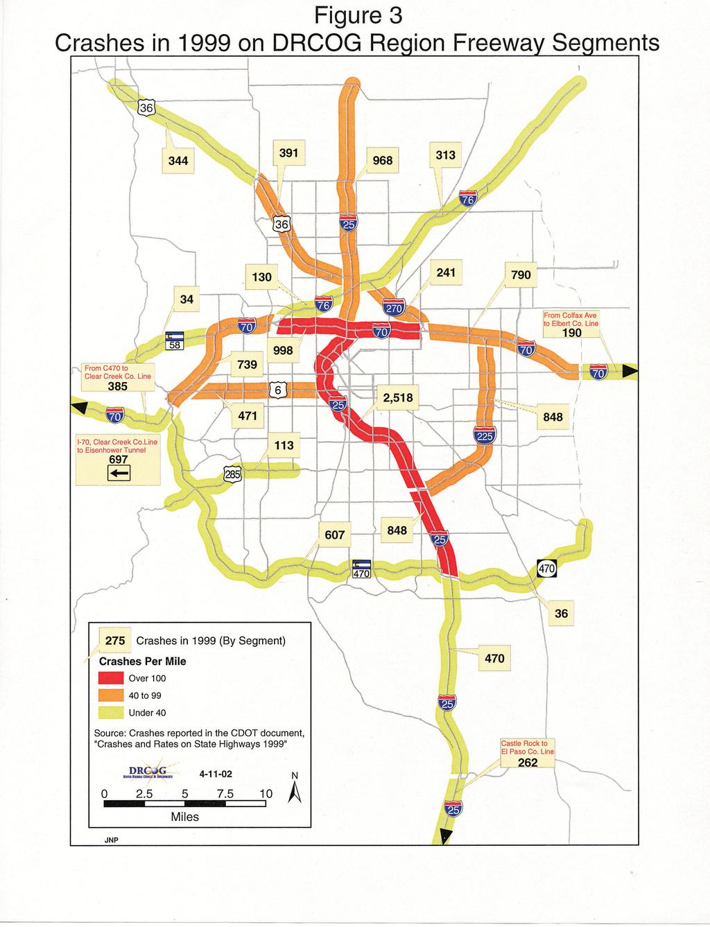
16 Some roads are more prone to crashes because of the type of road and users. If a driver is traveling 30 miles per hour on a street with a center median island and shoulders, a momentary error in driving judgment may not result in a crash. However, that same error made on a 55 mile-per-hour highway with no shoulders or median treatments could result in a serious crash. Crashes on Freeways. Because of their very high daily traffic volumes, some with more than 200,000 vehicles per day, urban freeways have a high number of crashes. These crashes can have a major impact on regional travel. Figure 3 shows the number of reported crashes on the freeways of the DRCOG region in The 12-mile section of I-25 from I-70 to I-225 was the site of over 2,500 crashes, or an average of almost seven crashes (with five injured persons) per day. The number of crashes was less on the lower-volume suburban and rural freeways, as expected, but all freeway segments in the region were the site of several hundred annual crashes. The highest numbers of fatalities were reported on some of the more rural sections. I-25 from Castle Rock to the El Paso County line recorded the highest number of fatalities, with eight. Overall, however, the crash rate per vehicle miles traveled on freeways is actually less than that for city streets. These figures represent only reported crashes; unreported crashes and mechanical breakdowns also create an unsafe environment and excessive delays for other drivers on a daily basis. Crash Types. Table 4 presents the frequency of various types of crashes that occurred in a typical year in the Denver region. Rear-end crashes were, by far, the most frequent type, representing 34 percent of all crashes in Broadside collisions accounted for about 16 percent of crashes. Sideswipe crashes and crashes involving a vehicle striking a fixed object, such as a telephone pole, tree, or building, each represented about 12 percent of 2001 crashes. Injury and death of pedestrians and bicyclists occur at a disproportionate rate compared to that of motor vehicle occupants. While only 2.1 percent of the reported crashes in 2001 involved a pedestrian or bicyclist being struck, 17 percent of all crash fatalities were pedestrians or bicyclists. Table 5 shows the number of crashes involving bicycles and pedestrians. In 2001, 39 pedestrians and eight bicyclists were killed in traffic crashes in the Denver region. Another 692 pedestrians and 454 bicyclists were injured. When compared to the other 50 most-populated cities in the country, the City and County of Denver had the second highest rate of pedestrian fatalities in Its value of 6.3 fatalities per 100,000 persons was higher than every city except Miami, and was much higher than the median value of 2.4. It should be kept in mind that factors such as weather conditions, the popularity of walking, and the number of tourists and cultural venues play a role in pedestrian and bicyclist exposure to crashes and should be considered when looking at comparative safety data. 8 Chapter 1. Introduction
17
18 Table 4. Types of Crashes, DRCOG Region, 2001 Number Percentage rear-end collision 27, % broadside collision 12, % struck fixed object 9, % sideswipe - same direction 9, % collision during opposite turn 5, % parked vehicle struck 4, % rollover or other non-collision 1, % sideswipe - opposite direction 1, % head-on collision 1, % pedestrian struck 1, % collision while overtaking % collision with bicycle or motorized bicycle % animal struck % collision with road maintenance vehicle % collision with train % unknown 2, % Total 79, % Source: Colorado Department of Transportation data file Table 5. Pedestrian and Bicyclist Involvement in Crashes, DRCOG Region, 2001 Pedestrians Bicyclists County Crashes Injuries Fatalities Crashes Injuries Fatalities Adams Arapahoe Boulder Broomfield Clear Creek Denver Douglas Gilpin Jefferson TOTAL Source: Colorado Department of Transportation data file 10 Chapter 1. Introduction
19 Crash Circumstances. Table 6 examines Denver-region crashes in 2001 from a variety of perspectives. Single-vehicle incidents accounted for 16 percent of all crashes. These make up most of the category of run-off-the-road crashes and most result in a rollover or in striking a fixed object such as a tree or guardrail alongside the road. Over 100 crashes were reported that involved six or more vehicles. Overall, about 11 percent of crashes occurred during adverse weather conditions and over 30 percent of all crashes took place during non-daylight hours. Table 6. Crash Circumstances, DRCOG Region, A. Vehicles Involved two 73.6% one 16.0% more than two 10.4% 4B. Location on Road on road 87.7% run-off-road 12.1% across divided highway 0.3% 4C. Adverse Weather none 89.1% snow/sleet/hail 6.2% rain 4.2% wind 0.3% fog 0.2% dust 0.01% 4D. Time of Day - Lighting daylight 69.5% dark 26.5% dawn/dusk 4.0% Source: Colorado Department of Transportation data file 11 Chapter 1. Introduction
20 2. Regional Safety Issues Improving traffic safety involves making difficult decisions about which techniques or policies to employ. This chapter surveys current issues that local, regional, and state governments face in trying to reduce the likelihood of crashes. The complexities involved in implementing various safety-enhancing techniques are examined. Controversial elements and legal obligations involved are also addressed. These issues are faced every day by legislators and local officials as they try to provide a safer environment for their constituents. All implications must be weighed together to produce a package of safety techniques that provides the most desirable outcome along each transportation route. Four types of traffic safety issues are examined: facility design, driver behavior and related enforcement and legislation, vehicle-related issues, and incident management. A. Transportation Facility Physical Issues The FHWA estimates that more than 15,000 highway deaths a year in the United States may be related to substandard road conditions, obsolete road design, and roadside hazards. Though roadway designs can be improved to address specific safety conditions, such improvements may have ramifications that can increase the chance for other types of crashes. This is a common dilemma faced by engineers and decisionmakers. There are rarely clear- cut answers to safety design issues. Examples of Specific Issues Real vs. Perceived Unsafe Locations. Choosing which transportation locations should be designated as less safe or high priority and how to allocate resources to improve safety are difficult decisions. Often a particular roadway may be perceived by local residents as dangerous because of a few highly publicized crashes. These high profile cases can divert attention from locations that may actually have higher crash rates. Signs and Signals. Local decision-makers are frequently faced with a call for a new traffic signal or four-way stop sign at a dangerous intersection. However, it is possible that, in some locations, unwarranted signs or signals may cause increases in other types of crashes. The cost of adding any type of traffic signal or warning and regulatory signs must be weighed against the potential benefit. Possible desensitization of drivers to excessive signage should be taken into account. For example, warning signs such as Children at Play signs should only be used in areas where one would not expect to see children. Pedestrian Interaction with Traffic. Traffic safety efforts in the past have focused heavily on the safety of motor vehicle occupants. However, about 16 percent of all traffic-related fatalities in the Denver region are pedestrians and 3 percent are bicyclists. Thirty-nine pedestrians were killed in the region in Pedestrians are usually encouraged to use crosswalks at signalized intersections, but these can sometimes be dangerous locations because of the 12 Chapter 2. Regional Safety Issues
21 number of turning vehicles. The safety of mid-block crosswalk markings is also debated. While acknowledging the benefits of increased visibility to drivers, some studies suggest that marked mid-block crosswalks provide a false sense of security to pedestrians who then do not look for vehicles before they cross. Newer approaches such as lighted crosswalk markings are being experimented with in some communities throughout the country, including Boulder. Another point to note regarding pedestrian safety is the number of pedestrian traffic fatalities that occur on freeways. In 2001 in the Denver region, 17 freeway crashes involved a pedestrian. Only five of those crashes did not result in an injury or fatality. Pedestrians are prohibited from freeways, but many of those injured or killed were persons standing outside disabled vehicles who were struck by another vehicle. Those injured or killed may have been the original vehicle occupants or law enforcement personnel, emergency response workers, or good Samaritans helping out. These situations could be improved by requiring drivers to carry reflective warning markers in their vehicles, as is the law in some European countries. Bicycle Interaction with Traffic. Provision of comfortable riding space for bicyclists is sometimes a contentious issue. Some cyclists favor on-road facilities like bike lanes, while others prefer off-street bike paths. Off-street paths are often perceived to be safer; however, their intersections with streets, driveways, and sidewalks can create conflict points and bicyclists may actually be at greater risk of a crash. Care should be taken to provide sufficient sight distance for cyclists, drivers, and pedestrians at intersections. Regulatory signs such as stop signs for off-street path users and warning signs for drivers approaching offstreet path crossings should be provided. Sidewalks are often used by young and less-experienced bicyclists, but riding on sidewalks may actually increase the number of conflicts with cars and pedestrians, and the sight distance for cyclists and drivers may be diminished. Many cities, including Denver, have ordinances prohibiting people from riding bicycles on sidewalks. In communities where bicycles can be ridden on the sidewalk, bicyclists must dismount and walk their bicycles across crosswalks to be afforded the right to have cars yield to them. The Colorado legislature recently considered a law that would require children 14 and younger to wear bicycle helmets and require bicycle rental shops to provide helmets, but the bill failed to receive enough support to reach a vote. Railroad Crossings. Railroad crossings create a potential conflict between trains and all other modes of travel. About 400 people were killed and almost 1,400 seriously injured in highway-rail crossing crashes in the United States in Freight rail activity is increasing in frequency in the Denver area and additional light rail lines are being built. Decisions will need to be made on how new rail lines will intersect with traffic lanes and pedestrian crossings. At-grade crossings can also have an impact on congestion as well as safety. Separated 13 Chapter 2. Regional Safety Issues
22 grade crossings, however, are expensive, and are not financially feasible at all crossings; citizens also sometimes object to them for aesthetic reasons. Rumble Strips. Rumble strip grooves cut into the pavement along highway shoulders and along road centerlines warn drivers when they stray from their proper lanes. They have been shown to reduce run-off-the-road crashes by 15 to 70 percent. Care should be taken in implementing rumble strips, however, because certain styles create a hazard for motorcyclists and bicyclists that may have to ride over them. In addition, adequate smooth riding space for bicyclists should be provided on shoulders that have rumble strips. Shoulders. Many of Colorado s rural two-lane roadways were built without shoulders. Widening shoulders by four feet on certain types of roadways has been shown to decrease crashes by almost 30 percent. The shoulder provides additional maneuvering space for vehicles trying to avoid crashes and provides a breakdown lane that helps reduce congestion and danger to other drivers and persons attending to disabled vehicles. Shoulders can also be designated as bicycle facilities. However, the extra space on the side of the road may create a perception of safety that may encourage drivers to drive faster, possibly increasing the likelihood or severity of a crash. Drainage Grates. Another issue faced by road designers is the type of drainage grate or catch basin used to capture rain or snowmelt runoff. While the most efficient type of drainage grate is desired, consideration must also be given to the impacts on bicyclists using the roadways. Narrow travel lanes may force some bicyclists to ride in the gutter area. Many types of grates can grab bicycle wheels and cause serious crashes. Bicycle-friendly drainage grates have openings that are perpendicular or diagonal to the curb and are flush with the roadway surface. Traffic Calming. Traffic calming involves the use of features such as speed humps, roadway narrowings, and traffic circles to slow traffic, particularly in residential neighborhoods. The resulting reduced speeds and minimized potential conflicts have been shown to reduce crashes. However, the public has sometimes objected to these features. The City of Boulder had a typical experience as it implemented traffic calming measures through its Neighborhood Traffic Mitigation Program in While many neighborhood residents were eager to see traffic calming devices installed to slow traffic, others regarded them as an annoyance. Concerns over emergency vehicle response times were also expressed. Winter Maintenance. Removal of snow and prevention of ice buildup is essential to winter traffic safety. The winter maintenance techniques most commonly used in the DRCOG region are sanding and the spreading of magnesium chloride. Spreading of sodium chloride, or rock salt, the most commonly-used and cost-effective deicing strategy used in the United States, is 14 Chapter 2. Regional Safety Issues
23 not commonly utilized in Colorado. By melting ice more quickly and by allowing more efficient snow removal with snowplows, salt and magnesium chloride make roadways considerably safer for drivers and emergency vehicles. Research has found that the injury crash rate in winter weather is reduced by more than nine times after spreading of salt. More effective snow and ice removal also lessens air pollution by reducing congested traffic. Reducing the use of sand would improve air quality, as sand particles contribute to airborne particulate pollution, which has been a long-standing concern in the Denver region. In addition, severe sedimentation in some streams in Colorado has been caused by road sand. Debate exists in the choice between salt and magnesium chloride. Salt is considerably less expensive, but it has a more corrosive effect on cars and infrastructure and can damage vegetation. A conclusive determination of the environmental effects of magnesium chloride has not been established. Magnesium chloride is more effective than salt at lower temperatures, but has also been implicated in causing power outages when spray from coated roads shorts out electric pole insulators. Work Zone Safety. Nearly 1,100 fatalities occurred in road construction work zones in the United States in This represents a substantial increase over the average of 820 deaths per year from 1994 to With hundreds of miles of road construction planned for the Denver region, work zone safety for both workers and drivers will become a greater concern. Reconstruction of roadways necessarily creates potential hazards by narrowing lanes, eliminating lanes and shoulders, and adding temporary curves and jogs to roadways. Nighttime construction has been instituted on many projects to minimize the impact of construction activities on the peak hours of traffic, but greater danger may be created for workers and drivers. Nearly 60 percent of all work zone fatalities occur at night, when visibility is reduced and when drivers are more fatigued and more likely to be under the influence of alcohol or drugs. B. Driver Behavior, Enforcement, and Legislative Issues As illustrated in Figure 2, most crashes are the result of either inattentive or aggressive driver behavior. Many of these behaviors can be addressed through education, in combination with legislation and enforcement efforts. Resistance is often encountered, however, when new laws are seen as infringing on individuals rights. Examples of Specific Issues Aggressive Driving and Road Rage. Aggressive driving, often accompanied by the verbal or physical abuse of road rage, has attracted considerable attention recently throughout the country. The Colorado State Patrol (CSP) classifies the following as aggressive driving behaviors: 15 Chapter 2. Regional Safety Issues
24 lane violations following too closely failure to yield right-of-way improper passing driving on the wrong side of the road disregarding stop signs driving under the influence speeding Aggressive driving behaviors were the primary cause of about 48 percent of Colorado crashes in CSP reported an 8.2 percent increase in these types of crashes from 1999 and has focused on enforcing laws related to aggressive driving. Congested roadways are seen as a contributing factor in aggressive driving, and as the Denver region s roads become more congested, the problem will likely worsen. Many states have enacted aggressive driving statutes, though the potential benefits of road rage legislation have not been clearly defined. Several pieces of aggressive driving legislation were brought before the Colorado state legislature in 2001 and were rejected. At the local level, however, some communities in the region have enacted laws designed to combat road rage. Douglas County allows police officers to double traffic fines if they feel an offense is the result of aggressive driving. The City of Aurora has implemented a campaign combining multimedia education efforts and targeted enforcement against aggressive driving that has been lauded by the U.S. Conference of Mayors. Results in the first half of 1998 found 40 percent more traffic tickets had been issued in Aurora while crashes with injuries had dropped about 9 percent. Distracted Driving. The CSP attributed almost one-fourth of all crashes it investigated in 2000 to inattentive driving, making it the largest category of primary crash causes. Activities such as eating, smoking, interacting with passengers, and adjusting the radio contribute to driver inattention to the roadway. Driving while fatigued or sleepy has also been noted as a major contributor to crashes. Increased cellular phone use while driving has recently drawn considerable attention. A NHTSA study found 54 percent of drivers usually have a cellular phone in their vehicle, and 73 percent say they have used a phone while driving. A NHTSA observational study in 2000 concluded that, at any given moment, 3 percent of all drivers on the road are using a hand-held cellular phone. Advances in wireless technology such as and web browsers may create additional potential distractions to driving. Numerous local jurisdictions across the country have enacted bans on using hand-held cellular phones while driving and at least 14 states have some sort of law in force or pending. Opponents of the laws argue that cellular phone use is no more distracting than other activities that are not regulated. 16 Chapter 2. Regional Safety Issues
25 Certain types of roadside objects may also contribute to driver distraction. Billboards with changing advertisements have been labeled by some as a driver distraction. These types of signs were approved for use along Colorado highways in Enforcement of Laws Applying to Bicyclists. In Colorado, bicyclists must abide by the same laws and rules of the road as motor vehicle drivers. Field surveys have shown that significant numbers of bicyclists ride the wrong way on streets and disobey stop signs and red lights. However, bicyclists are rarely cited for violations such as these or for infractions like improper turns or riding without a light at night. Impaired Driving. Driving under the influence of alcohol or drugs (DUI) is perhaps the most well-publicized cause of traffic crashes. Increased education and enforcement efforts in recent decades have reduced these types of crashes, but impaired driving is still involved in more than 4,200 crashes a year in Colorado. DUI crashes are almost twice as likely to result in fatalities or injuries as crashes that do not involve alcohol or drugs. The Colorado legislature recently considered a bill that would lower the minimum blood alcohol level for DUI from 0.10 to If the lower blood alcohol limit is not established, the state could lose almost $50 million in federal transportation funding over the next four years. The legislature also considered a law prohibiting open containers of alcohol in vehicles; Colorado is one of the few states without such a law. Older and Younger Drivers. Persons in the youngest and oldest age groups are the ones most likely to be involved in traffic crashes, especially fatal crashes (Figure 4). Drivers aged 70 years and older make up 9 percent of the total U.S. population, but account for almost 14 percent of traffic fatalities. Similarly, young people aged 15 to 20 years old make up 7 percent of the population, but represent 15 percent of driving fatalities. Motor vehicle crashes are the leading cause of death for persons in that age group, representing one-third of deaths. In an attempt to counter the inexperience and increased risk-taking of young drivers, the State of Colorado instituted graduated licensing for first-time drivers in Minors are now required to hold an instruction permit for at least six months, during which time they must log 50 hours of driving experience, including 10 hours at night. In addition, all passengers in a car with a driver under 17 must wear seat belts. Since the introduction of graduated licensing in 1999, CDOT reports fewer teen deaths in automobile crashes and a drop in the rate of fatal crash involvement of teens from 46 per 100,000 crashes in 1998 to 22 per 100,000 in Other age-related driving topics that are frequently discussed include raising the driving age, mandatory retesting of elderly drivers, and imposing night driving restrictions on younger and older drivers, but these have not been addressed by the legislature. 17 Chapter 2. Regional Safety Issues
26 Figure 4. National Fatality Rate by Age Group, 1996 Fatalities per 100 Million Vehicle Miles Traveled Age Group Source: NHTSA Photo Enforcement of Speeding and Red Light Running. Colorado is one of 10 states that permit the use of photo radar and red light cameras. These tools are seen as effective in enforcing speed limits and red light laws without significant expenditure on police manpower. Excessive Speed and Speed Limits. High rates of speed are cited in many crashes, both urban and rural. As Figure 2 indicates, excessive speed is implicated as the second most common cause of crashes in Colorado. Even when vehicles are traveling at or near the speed limit, high speeds can increase the likelihood and severity of a crash. Drag racing has been associated with a number of recent serious crashes in the Denver region and is seen by local police as an increasing problem. Red Light Running. Over 1.8 million intersection crashes occur every year in the United States, accounting for approximately 44 percent of all crashes. Red light running is the cause of many of these crashes and is the leading cause of urban crashes in the country. FHWA found that 56 percent of Americans admit to running a red light. Research has shown that photo enforcement can reduce red light running by 40 percent; the city of Fort Collins reported an 18 percent reduction in crash injury rates after implementation of photo radar. While the use of cameras has been shown to be effective, it is often viewed by citizens as unfair or intrusive. Several communities have experienced legal challenges to camera use. Denver s recent experience with photo radar points out some of the complications. Lawsuits over issuance of tickets by a third party, not police, led to photo radar being seen as a revenue-producing program rather than as a safety tool. The Colorado legislature recently enacted changes to photo enforcement laws. Photo radar can now only be used in residential neighborhoods, in school zones, and near parks, and not on arterial streets. A municipal employee must be present when 18 Chapter 2. Regional Safety Issues
27 photo radar equipment is in use, drivers must be warned when entering photo radar enforcement zones, and fines are limited to $75. Safety Inspections. Twenty states require mandatory safety inspections of vehicles at the time of registration or renewal of registration. These inspections aim to ensure that safety-related systems are working properly. For instance, the New Jersey inspection examines the steering, suspension, horn, wipers, window glazing, lights, direction signals, red rear lights, mirrors, brakes, hazard signals, and seat belts. A General Accounting Office study found that states with required motor vehicle safety inspections have been found to have crash rates 17 percent lower than those without such programs. Colorado vehicles in areas with air quality problems, including most of the Denver region, must be inspected for emissions, but no safety inspection is conducted. Seat Belts and Child Safety Seats. Seat belts have been clearly shown to reduce the risk of fatal injury by about half, yet 30 percent of Americans do not use belts regularly. The state of Colorado requires seat belt use by drivers, front seat passengers, and all children not required to use a child safety seat. NHTSA reports a seat belt use rate in Colorado of 65 percent, about 5 percent below the national average. As in about three-fifths of the states with seat belt laws, Colorado s law currently specifies that a driver must be stopped for another violation before being ticketed for not wearing a seat belt. The Colorado legislature is considering a law that would allow primary enforcement of seat belt laws. States that have primary enforcement laws have found that seat belt usage rates have increased. Traffic crashes are the number one killer of Americans aged 1 to 15. The single most dangerous place for children is in a motor vehicle. Colorado has recently expanded its child safety seat laws, which previously only required that children under 4 use child safety seats. Children 4 and 5 years old and those under 55 inches tall are now required to use booster seats, which help seat belts better fit children. In addition, the new law requires that children under 1 year old be restrained in a rear-facing child safety seat. Some states have even more stringent requirements, with child safety seats required for children up to 8 years old. A significant problem associated with child safety seats is proper use of the seats. The National Transportation Safety Board reports that safety seat checkpoints often find that up to 80 percent of seats are used incorrectly. Air bags are another safety concern for children. They provide a tremendous amount of protection from injury for adults, but they are not safe for children under 80 pounds, who can be seriously injured or killed by the rapidly inflating airbags. Installation of seat belts in school buses has also become an issue. Some local school districts, including Denver, Aurora, Cherry Creek, and Douglas and 19 Chapter 2. Regional Safety Issues
28 Jefferson counties, have seat belts on some buses, although many currently only include them on buses for disabled students. Opposition to installing belts on buses focuses on cost, design questions, and uncertainty as to the benefit of current designs. Sight Distance. Some crashes that occur as vehicles pull away from intersections or out of driveways are the result of the driver s vision being blocked by roadside obstructions. Local zoning ordinances regarding sight triangle obstructions such as overgrown vegetation or fencing near the roadway must be enforced so that drivers can make better judgments when entering roadways. Enforcement of local zoning ordinances can also enhance pedestrian safety by assuring sidewalks are not blocked by vegetation or snow. C. Vehicle-related Issues Technological advances such as airbags and crash warning systems have been implemented or are being studied by vehicle manufacturers, and will continue to improve traffic safety. However, certain types of vehicles such as trucks and motorcycles are involved in a disproportionate number of fatal crashes. To improve safety for all travelers, the special issues related to these vehicles should be addressed. Legislation, enforcement, education, and changes in vehicle design can reduce these types of crashes. Examples of Specific Issues Commercial Vehicles. Commercial trucks and buses on highways can present a safety threat beyond that of passenger cars. Large trucks account for 3 percent of all registered vehicles in the country, but are involved in 13 percent of all crashes involving fatalities. An average of 66 people are killed every year in Colorado in crashes involving large trucks. Spills from truck crashes can also have serious environmental impacts on water sources, wildlife, and vegetation. While some of these crashes are the fault of the truck driver, many are caused by automobile drivers performing unsafe maneuvers near trucks. The issues states have generally focused on in promoting truck and commercial bus safety include: deciding whether to allow multiple-trailer trucks combating truck driver fatigue and aggressive driving implementing education efforts to inform other drivers of how to share the road with trucks mandating more stringent vehicle inspections When the federal Motor Carrier Safety Administration was created in 1999, groups such as the American Automobile Association fought to ensure that state funding for truck safety programs was not cut. Recent changes to federal law imposing tougher inspections on commercial trucks from Mexico should also benefit Colorado highway safety. 20 Chapter 2. Regional Safety Issues
29 Motorcycles. Nationwide, the number of annual motorcycle fatalities has been steadily increasing, growing by 45 percent from 1997 to Colorado is one of only three states that does not have any type of motorcycle helmet law. Helmets have been estimated to reduce the risk of death in a motorcycle crash by 29 percent and are even more effective in reducing brain injuries. In 2000, 73 people were killed on motorcycles in Colorado; 31 of those were not wearing helmets. SUVs. As sport-utility vehicles (SUVs) have begun to make up a greater proportion of all passenger vehicles on Colorado roads, concern has been raised regarding their role in crashes. Although CDOT and local agencies do not monitor the number of crashes involving SUVs specifically, the vehicles have been asserted to be involved in crashes at a greater rate than passenger cars. Research has shown that in a two-car collision between an SUV and a passenger car, the occupants of the car are twice as likely to be killed, while the occupants of the SUV are 10 to 20 percent less likely to die than if they are struck by a vehicle of equal weight. D. Emergency Response and Incident Management While it does not stop the initial crash from happening, emergency response affects many crash outcomes. Faster response times and improved rescue techniques and hazardous materials response can reduce the danger for those involved in the crash, for emergency workers, and for drivers passing by the crash. Examples of Specific Issues District Cooperation. Emergency medical services in the Denver region are largely unregulated, resulting in the numerous local districts sometimes having disputes over territory. As a result of a tradition of local control, and exacerbated by the rapid growth of the region and competition between public and private providers, there is little coordinated cooperation between districts. NHTSA warned the State of Colorado in 1997 about the lack of cooperation among districts. Recent efforts at consolidation of smaller districts have met with mixed success. Incident Management. Incidents such as crashes or breakdowns along roadways create safety issues and contribute heavily to congestion. It is estimated that over 60 percent of all traffic delays in metropolitan areas are attributable to these incidents. While the primary focus in managing an incident scene is treating the injured and making the crash scene safe for both crash victims and respondents, response to incidents can greatly increase delay to motorists, yielding secondary crashes. CDOT s current Move It campaign reminds drivers of state law that requires them to move vehicles involved in crashes out of travel lanes as soon as possible if damage is minor, if there are no severe injuries, or if alcohol is not involved. 21 Chapter 2. Regional Safety Issues
Road Safety Audit Course Participant Guidebook. August 22 & 23, Cleveland Avenue Columbus, Ohio
 Road Safety Audit Course Participant Guidebook August 22 & 23, 2017 Cleveland Avenue Columbus, Ohio 1 2 Table of Contents Executive Summary... 5 Cleveland Avenue City of Columbus... 6 Road Location Details...
MTCF. Michigan Traffic Crash Facts FACT SHEETS
 FACT SHEETS This page left intentionally blank GENERAL FACTS The driver, the roadway, and the motor vehicle contribute in some measure to every crash. A preponderance of evidence, however, points to driver
2012 TOWN OF CASTLE ROCK MOTOR VEHICLE ACCIDENT FACTS PREPARED BY THE PUBLIC WORKS DEPARTMENT
 ATTACHMENT A 2012 TOWN OF CASTLE ROCK MOTOR VEHICLE ACCIDENT FACTS PREPARED BY THE PUBLIC WORKS DEPARTMENT ACKNOWLEDGEMENTS This report was assembled from data provided by the Castle Rock Police Department
MTCF. Michigan Traffic Crash Facts FACT SHEETS
 FACT SHEETS This page left intentionally blank GENERAL FACTS The driver, the roadway, and the motor vehicle contribute in some measure to every crash. A preponderance of evidence, however, points to driver
Appendix C. TRAFFIC CALMING PROGRAM TOOLBOX
 Appendix C. TRAFFIC CALMING PROGRAM TOOLBOX PHASE I...2 Do Not Enter Sign...3 One-Way Sign...4 Turn Prohibition...5 Pavement Markings...6 Speed Monitoring Trailer...7 Neighborhood Speed Watch...8 Police
BICYCLING ON ROADWAYS
 Massachusetts State Police Academy Training Bulletin 2017-11 BICYCLING ON ROADWAYS Legal Update: Effective April 2017, Chapter 456 of the Acts of 2016 adds section 4D to Chapter 89 of the General Laws,
Unit Six: Driving Faster with More Risk URBAN, SUBURBAN, AND RURAL DRIVING
 Unit Six: Driving Faster with More Risk URBAN, SUBURBAN, AND RURAL DRIVING What Is The Impact Of Distraction? Objectives For Unit Six Students will be able to describe the skills necessary to What safely
Toward Zero Deaths. Regional SHSP Road Show Meeting. Virginia Strategic Highway Safety Plan. presented by
 Toward Zero Deaths Regional SHSP Road Show Meeting presented by Virginia Strategic Highway Safety Plan December 1, 2016 1 Welcome & Introductions Purpose of the Meeting Objectives & Key Outcomes Agenda»
Why Zone In on Speed Reduction?
 Learn it. Do it. Live it! SPEED REDUCTION IN THE ZONE Why Zone In on Speed Reduction? Speeding is a serious issue that plays a major role in the risk of serious injury and pedestrian fatality in a crash.
road safety issues 2001 road toll for Gisborne district July 2002 Road user casualties Estimated social cost of crashes*
 GISBORNE DISTRICT road safety issues July 22 The Land Transport Safety Authority (LTSA) has prepared this Road Safety Issues Report. It is based on reported crash data and trends for the 1997 21 period.
COLLISION STATISTICS May Engineering Services Box 5008, th Avenue Red Deer, AB T4N 3T4
 COLLISION STATISTICS 2016 2016 Red Deer Annual Motor Vehicle Collision Report May 2017 Engineering Services Box 5008, 4914 48th Avenue Red Deer, AB T4N 3T4 engineering@reddeer.ca RCMP GRC Red Deer City
CDRT. Child Death Review Team Dallas County. Brief Report Traffic-related Child Deaths OVERVIEW
 Dallas County CDRT Child Death Review Team 2013 Brief Report Traffic-related Child Deaths 2006-2011 OVERVIEW In Dallas County, traffic-related injury death rates among children are typically less than
2003 road trauma for. Wairoa District. Road casualties Estimated social cost of crashes* Major road safety issues WAIROA DISTRICT JULY 2004
 WAIROA DISTRICT JULY 24 T he Land Transport Safety Authority (LTSA) has prepared this road safety issues report. It is based on reported crash data and trends for the 1999 23 period. The intent of the
Institute of Transportation Engineers Safety Action Plan
 I Institute of Transportation Engineers Safety Action Plan 1. Introduction 2. Intersection Crashes 3. Keep Vehicles on the Road 4. Minimize Consequences When Vehicles Leave the Road 5. School Crossing
MUTCD Part 6G: Type of Temporary Traffic Control Zone Activities
 MUTCD Part 6G: Type of Temporary Traffic Control Zone Activities 6G.01 Typical Applications Each temporary traffic control (TTC) zone is different. Many variables, such as location of work, highway type,
Ohio Share the Road Driver s s Education Unit
 Ohio Share the Road Driver s s Education Unit Bicyclists are Drivers of Vehicles 4501.01. Definitions (A) "Vehicle" means every device, including a motorized bicycle, in, upon, or by which any person or
Pedestrians safety. ROAD SAFETY SEMINAR PIARC/AGEPAR/GRSP Lome, Togo October 2006 Lise Fournier, Canada-Qu
 Pedestrians safety ROAD SAFETY SEMINAR Lome, Togo October 2006 Lise Fournier, Canada-Qu Québec Contents WHO s data Risk factors Pedestrian needs Pedestrian facilities Conclusion Source: WHO WHO reports
Report on Traffic Crashes in the Denver Region
 Denver Regional Council of Governments Report on Traffic Crashes in the Denver Region REVIEW DRAFT October 2016 1290 Broadway Denver, CO 80203 www.drcog.org Table of Contents 1. Introduction... 1 A. Background
Occ c u c pa p n a t pro r t O ec e t c i t O i n
 Occupant Protection Occupant Protection Introduction Buckling up or being buckled in is the most effective protection during a car crash. The simple truth is that the great majority of people ejected from
Alberta. Traffic Collision Statistics. Office of Traffic Safety Transportation Services Division May 2017
 Traffic Collision Statistics Office of Traffic Safety Transportation Services Division May 217 This page was intentionally left blank. 2 Table of Contents Traffic Collisions... 4 Traffic Collision Rates...
TRAFFIC CALMING GUIDE FOR TORONTO CITY OF TORONTO TRANSPORTATION SERVICES DIVISION
 TRAFFIC CALMING GUIDE FOR TORONTO CITY OF TORONTO TRANSPORTATION SERVICES DIVISION CITY OF TORONTO TRANSPORTATION SERVICES DIVISION 2016 TRAFFIC CALMING GUIDE FOR TORONTO TABLE OF CONTENTS Introduction
Bicycle - Motor Vehicle Collisions on Controlled Access Highways in Arizona
 Bicycle - Motor Vehicle Collisions on Controlled Access Highways in Arizona Analysis from January 1, 1991 to June 30, 2002 Richard C. Moeur, PE Traffic Design Manager, Northern Region Michelle N. Bina
Keep Customers and Ourselves Safe. Mark Shelton, District Engineer. Tracker. Measures of Departmental Performance
 Keep Customers and Ourselves Safe Mark Shelton, District Engineer Tracker Measures of Departmental Performance Safety is a daily commitment for all MoDOT employees. From design and construction to operations
General Design Factors
 Chapter 3: 3-1.0 Introduction General Design Factors Mn/DOT s goals include encouraging and accommodating safe bicycling. From a design perspective, these goals are achieved by first having an understanding
2014 QUICK FACTS ILLINOIS CRASH INFORMATION. Illinois Emergency Medical Services for Children February 2016 Edition
 2014 QUICK FACTS ILLINOIS CRASH INFORMATION February 2016 Edition Illinois Emergency Medical Services for Children www.luhs.org/emsc Illinois Emergency Medical Services for Children TABLE OF CONTENTS
2012 QUICK FACTS ILLINOIS CRASH INFORMATION. Illinois Emergency Medical Services for Children September 2014 Edition
 2012 QUICK FACTS ILLINOIS CRASH INFORMATION September 2014 Edition Illinois Emergency Medical Services for Children www.luhs.org/emsc Illinois Emergency Medical Services for Children TABLE OF CONTENTS
Florida Class E Knowledge Exam Road Rules Practice Questions
 1. If you are being followed too closely while driving, you should: A. Drive closer to the car in front of you. B. Speed up to increase the distance between you and the following vehicle. C. Slow down
$ 12" $#&%$ 86.) *1! *1 /3 )00, , (1* Neighborhood Traffic Calming Part 3 Solutions Bradley William Yarger, P.E.
 *1! *1 /3 )00, , (1* Neighborhood Traffic Calming Part 3 Solutions Bradley William Yarger, P.E.") $ 12" $#&%$ 86.)3+5+2 714 *1! *1 /3 )00,12 3.+ -0127 1, (1* Neighborhood Traffic Calming Part 3 Solutions by Bradley William Yarger, P.E. It is extremely tempting to jump to this step of the process thinking
$ 12" $#&%$ 86.)3+5+2 714 *1! *1 /3 )00,12 3.+ -0127 1, (1* Neighborhood Traffic Calming Part 3 Solutions by Bradley William Yarger, P.E. It is extremely tempting to jump to this step of the process thinking
PRELIMINARY DRAFT FIRST AMENDMENT TO VISION 2050: A REGIONAL LAND USE AND TRANSPORTATION PLAN FOR SOUTHEASTERN WISCONSIN
 PRELIMINARY DRAFT FIRST AMENDMENT TO VISION 2050: A REGIONAL LAND USE AND TRANSPORTATION PLAN FOR SOUTHEASTERN WISCONSIN ESTABLISHING TARGETS FOR FEDERAL PERFORMANCE MEASURES: HIGHWAY SAFETY SOUTHEASTERN
Prepared By: Town of Waxhaw Traffic Calming Policy
 Policy For Resolutions for Town Meetings Prepared By: Town Manager Michael McLaurin Director Greg Mahar CPD Waxhaw N.C. Community Planning &Development Administrative Department Department: Date Approved
For Information Only. Pedestrian Collisions (2011 to 2015) Resolution. Presented: Monday, Apr 18, Report Date Tuesday, Apr 05, 2016
 Resolution. Presented: Monday, Apr 18, Report Date Tuesday, Apr 05, 2016") Presented To: Operations Committee For Information Only Pedestrian Collisions (0 to 0) Presented: Monday, Apr 8, 06 Report Date Tuesday, Apr 0, 06 Type: Correspondence for Information Only Resolution For
Presented To: Operations Committee For Information Only Pedestrian Collisions (0 to 0) Presented: Monday, Apr 8, 06 Report Date Tuesday, Apr 0, 06 Type: Correspondence for Information Only Resolution For
A Strategic Highway Safety Plan. a coordinated and informed approach to reducing highway fatalities and serious injuries on all public roads.
 Introduction A Strategic Highway Safety Plan is a coordinated and informed approach to reducing highway fatalities and serious injuries on all public roads. A Strategic Highway Safety Plan is Based on
Active Transportation Facility Glossary
 Active Transportation Facility Glossary This document defines different active transportation facilities and suggests appropriate corridor types. Click on a facility type to jump to its definition. Bike
Comprehensive Measures to Reduce Traffic Accident Fatalities
 Comprehensive Measures to Reduce Traffic Accident Fatalities Outcomes: 4,621 people died as a result of traffic accidents in 2015. It represents 4% decrease compared to 2014. Year 2012 2013 2014 2015 Traffic
Lane Area Transportation Safety and Security Plan Vulnerable Users Focus Group
 Lane Area Transportation Safety and Security Plan Vulnerable Users Focus Group Agenda 1. Planning Process Review 2. What are Emphasis Areas? 3. Your Role Today 4. Data Review 5. Small group discussion
Turquoise Trail Corridor Management Plan Version 1.0
 9.0 NMSH & TD road crew maintaining the Turquoise Trail 9.1 SAFETY RECORD The accident data used in this chapter are derived from the NMSH&TD, primarily from their 1996 and 1997 database and from their
El Paso County 2040 Major Transportation Corridors Plan
 El Paso County 2040 Major Transportation Corridors Plan Connect-our-County Online Transportation User Survey Preliminary Results June 24, 2010 Years of Residence 2. How many years have you LIVED HERE?
APPENDIX F. Safety Planning. October 2018
 APPENDIX F Safety Planning October 2018 APPENDIX F: SAFETY PLANNING October 17, 2018 ABOUT VISUALIZE 2045 & THE TPB Visualize 2045 is the federally required long-range transportation plan for the National
road safety issues 2002 road trauma for TNZ Region Two July 2003 Road deaths Estimated social cost of crashes* Major road safety issues
 road safety issues July 23 22 road trauma for TNZ Region Two The Land Transport Safety Authority (LTSA) has prepared this road safety issues report. It is based on reported crash data and trends for the
Maine Highway Safety Facts 2016
 Maine Highway Safety Facts 216 216 MAINE HIGHWAY SAFETY FACTS The Bureau of Highway Safety and the Maine Department of Transportation are pleased to present the 216 edition of Maine Highway Safety Facts.
How to Develop a Pedestrian Safety Action Plan
 How to Develop a Pedestrian Safety Action Plan Course Introduction Presented by: Peter Eun FHWA RC Safety Engineer Ryan Snyder President, Ryan Snyder Associates, LLC Paul Zykofsky Director, Land Use and
Cycling and risk. Cycle facilities and risk management
 Cycling and risk Cycle facilities and risk management Failure to recognize possibilities is the most dangerous and common mistake one can make. Mae Jemison, astronaut 6/11/2010 York Regional Council Cycling
NYC Pedestrian Safety Study & Action Plan. NYTMC Brown Bag Lunch Presentation December 15, 2010
 NYC Pedestrian Safety Study & Action Plan NYTMC Brown Bag Lunch Presentation December 15, 2010 1 Introduction DOT Safety Goal Strategic Plan: Reduce Fatalities by 50% by 2030 From 274 (2007) to 137 (2030)
Driver Training School Instructor Curriculum Requirements for Student Learning & Performance Goals
 Driver Training School Instructor Curriculum Requirements for Student Learning & Performance Goals A driver training school s course of classroom and laboratory instruction is the key tool in establishing
Safety and Active Transport. Dr. Maureen Carew, Medical Officer of Health Renfrew County and District Health Unit May 30, 2014
 Safety and Active Transport Dr. Maureen Carew, Medical Officer of Health Renfrew County and District Health Unit May 30, 2014 Active Transport Vision Increase levels of walking and cycling Reduce vehicle
Napier City road trauma for Napier City. Road casualties Estimated social cost of crashes* Major road safety issues.
 ISSN 1176-841X July 25 Land Transport New Zealand has prepared this road safety issues report. It is based on reported crash data and trends for the 2 24 period. The intent of the report is to highlight
Improve the livability of our streets by
 Pedestrian and Traffic Calming Policy March 2018 2 of 6 Neighborhood Traffic Calming Policy The City of Aspen continually strives to protect multimodal function while maintaining a high standard of safety.
What Engineering Can Do for You! Low Cost Countermeasures for Transportation Safety
 What Engineering Can Do for You! Low Cost Countermeasures for Transportation Safety Adam Larsen Safety Engineer Federal Highway Administration 360-619-7751 Adam.Larsen@DOT.GOV Adam Larsen TTP Safety Engineer
DEPARTMENT OF ENVIRONMENTAL SERVICES. North Harrison Street (Lee Highway to Little Falls Road) Comparative Analysis. Prepared for:
 Comparative Analysis. Prepared for:") DEPARTMENT OF ENVIRONMENTAL SERVICES North Harrison Street (Lee Highway to Little Falls Road) Comparative Analysis Prepared for: Arlington County Department of Environmental Services 2100 Clarendon Boulevard,
DEPARTMENT OF ENVIRONMENTAL SERVICES North Harrison Street (Lee Highway to Little Falls Road) Comparative Analysis Prepared for: Arlington County Department of Environmental Services 2100 Clarendon Boulevard,
Deaths/injuries in motor vehicle crashes per million hours spent travelling, July 2007 June 2011 (All ages) Mode of travel
 Mode of travel") Cyclists CRASH STATISTICS FOR THE YEAR ENDED 31 DECEMBER 211 Prepared by the Ministry of Transport CRASH FACTSHEET 212 Cyclists have a number of risk factors that do not affect car drivers. The main risk
Cyclists CRASH STATISTICS FOR THE YEAR ENDED 31 DECEMBER 211 Prepared by the Ministry of Transport CRASH FACTSHEET 212 Cyclists have a number of risk factors that do not affect car drivers. The main risk
INTERSECTION CRASH COUNTERMEASURES
 INTERSECTION CRASH COUNTERMEASURES ALL SEVERE INTERSECTION (include gap CRASHES High Friction Surface Treatment - Intersection Markings - advanced acceptance and intersection approaches to intersections
By: Bill Baranowski, PE TRAFFIC CALMING EXAMPLES IN SUGARHOUSE, DAYBREAK, AND WEST JORDAN CITY
 By: Bill Baranowski, PE TRAFFIC CALMING EXAMPLES IN SUGARHOUSE, DAYBREAK, AND WEST JORDAN CITY 1977 HIGHLAND RUGBY TOUR 1945 WHERE??? What is more contentious than traffic calming? 1951 LOOKING SOUTHEAST
6.8 Transportation Safety & Security
 6.8 Transportation Safety & Security This chapter addresses transportation safety and security as required under MAP-21 and California s Strategic Highway Safety Plan. Transportation safety and security
SAFETY GUIDE FOR SCHOOL CHILDREN & PARENTS. toronto.ca/visionzeroto #VisionZeroTO
 SAFETY GUIDE FOR SCHOOL CHILDREN & PARENTS toronto.ca/visionzeroto #VisionZeroTO VISION ZERO ROAD SAFETY PLAN Toronto s Vision Zero Road Safety Plan is a five-year strategy for eliminating traffic-related
City of Vallejo Traffic Calming Toolbox
 City of Vallejo Traffic Calming Toolbox June 1, 2013 Final Table of Contents Introduction... 1 Non-Physical Devices... 3 High-Visibility Crosswalk... 3 In Pavement Lighted Crosswalk... 4 Rapid Flashing
5. RUNNINGWAY GUIDELINES
 5. RUNNINGWAY GUIDELINES These guidelines should be considered collectively when making runningway decisions. A runningway is the linear component of the transit system that forms the right-of-way reserved
Canadian Association of Chiefs of Police Association canadienne des chefs de police
 WHAT S IN THE KIT? Media Advisory Template To be used to invite the media to an event during Operation Impact. We suggest you reproduce this on your own police agency letterhead. News Release Template
o n - m o t o r i z e d transportation is an overlooked element that can greatly enhance the overall quality of life for the community s residents.
 N o n - m o t o r i z e d transportation is an overlooked element that can greatly enhance the overall quality of life for the community s residents. 84 Transportation CHAPTER 11 INTRODUCTION Transportation
We believe the following comments and suggestions can help the department meet those goals.
 The Honorable Secretary Anthony Foxx The Secretary of Transportation United States Department of Transportation 1200 New Jersey Avenue, SE Washington, DC 20590 August 30, 2013 Dear Secretary Foxx, Thank
CYCLISTS AND MOTORISTS SHARE THE ROAD SAND SPRINGS
 CYCLISTS AND MOTORISTS SHARE THE ROAD SAND SPRINGS Sand Springs Police Department Summary of Bicycle Laws in Oklahoma The Sand Springs Police Department receives many questions each year about cycling
M-58 HIGHWAY ACCESS MANAGEMENT STUDY Mullen Road to Bel-Ray Boulevard. Prepared for CITY OF BELTON. May 2016
 M-58 HIGHWAY ACCESS MANAGEMENT STUDY Prepared for CITY OF BELTON By May 2016 Introduction Missouri State Highway 58 (M-58 Highway) is a major commercial corridor in the City of Belton. As development has
CHAIR AND MEMBERS CIVIC WORKS COMMITTEE MEETING ON APRIL 25, 2016
 TO: FROM: SUBJECT: CHAIR AND MEMBERS CIVIC WORKS COMMITTEE MEETING ON APRIL 25, 2016 JOHN BRAAM, P. ENG. MANAGING DIRECTOR, ENVIRONMENTAL & ENGINEERING SERVICES AND CITY ENGINEER SCHOOL ZONE SPEED LIMIT
Road Safety Annual Report 2016 OECD/ITF Chapter 26. Morocco
 Road Safety Annual Report 2016 OECD/ITF 2016 Chapter 26 Morocco This chapter presents 2014 road safety data for Morocco along with provisional data from 2015. It looks at trends in traffic and road safety
Living Streets Policy
 Living Streets Policy Introduction Living streets balance the needs of motorists, bicyclists, pedestrians and transit riders in ways that promote safety and convenience, enhance community identity, create
REDUCING COLLISIONS AT HIGH CRASH LOCATIONS
 REDUCING COLLISIONS AT HIGH CRASH LOCATIONS Presented by Nazir Lalani P.E. Traffex Engineers Inc. N_lalani@hotmail.com ACCIDENTS AND SAFETY Why is safety important? Safety components Who is responsible?
Corpus Christi Metropolitan Transportation Plan Fiscal Year Introduction:
 Introduction: The Safe, Accountable, Flexible, Efficient Transportation Equity Act: A Legacy for Users (SAFETEA-LU) has continued the efforts started through the Intermodal Surface Transportation Efficiency
Bike to the Future c/o Portage Avenue. Winnipeg, MB. R3B 2B2 Fax:
 January 9, 2006 Bike to the Future c/o 3 330 Portage Avenue Winnipeg, MB R3B 2B2 Fax: 989-8476 biketothefuture@gmail.com www.biketothefuture.org Honourable Kerri Irvin-Ross Minister of Intergovernmental
City of Elizabeth City Neighborhood Traffic Calming Policy and Guidelines
 City of Elizabeth City Neighborhood Traffic Calming Policy and Guidelines I. Purpose: The City of Elizabeth City is committed to ensure the overall safety and livability of residential neighborhoods. One
Crosswalk event overview (Saint Paul) How to organize a crosswalk event. 1. Choose a date, time and location
 How to organize a crosswalk event. 1. Choose a date, time and location") Crosswalk event overview (Saint Paul) A crosswalk event occurs when an individual or group of individuals promote pedestrian safety by demonstrating the proper use of a crosswalk. During the event, a group
Crosswalk event overview (Saint Paul) A crosswalk event occurs when an individual or group of individuals promote pedestrian safety by demonstrating the proper use of a crosswalk. During the event, a group
Mission: The mission of FARS is to make vehicle crash information accessible and useful so that traffic safety can be improved
 Mission: The mission of FARS is to make vehicle crash information accessible and useful so that traffic safety can be improved NHTSA created FARS in 1975 National Center for Statistics and Analysis (NCSA)
EXECUTIVE SUMMARY. Vision
 Vision Walking and bicycling in Salt Lake City will be safe, convenient, comfortable, and viable transportation options that connect people to places, foster recreational and economic development opportunities,
We will also cover topics including sharing the road with: Emergency vehicles; Pedestrians; and Animals.
 Module 9 Sharing the Road We constantly share the roadway with others: vehicles of all sizes, pedestrians, bicyclists, motorcycles, and animals. Therefore you need to know and obey basic traffic laws regarding
Kentucky s Surface Transportation System
 Kentucky s Surface Transportation System ROAD AND BRIDGE CONDITIONS, TRAFFIC SAFETY, TRAVEL TRENDS, AND NEEDS MARCH 2018 PREPARED BY WWW.TRIPNET.ORG Founded in 1971, TRIP of Washington, DC, is a nonprofit
Engineering Countermeasures for Transportation Safety. Adam Larsen Safety Engineer Federal Highway Administration
 Engineering Countermeasures for Transportation Safety Adam Larsen Safety Engineer Federal Highway Administration 360-619-7751 Adam.Larsen@DOT.GOV Countermeasure Selection Resources Manual for Selecting
WILMAPCO Public Opinion Survey Summary of Results
 Wilmington Area Planning Council WILMAPCO Public Opinion Survey Summary of Results Prepared by: 2955 Valmont Road, Suite 300 Boulder, Colorado 80301 t: 303-444-7863 f: 303-444-1145 www.n-r-c.com Table
Road Safety Partnership
 Cambridgeshire and Peterborough Road Safety Partnership Cambridgeshire and Peterborough Road Safety Partnership Introduction Road accidents can have a devastating impact not only for the people directly
A Bicyclist s Guide to Traffic Law
 A Bicyclist s Guide to Traffic Law in Tucson and Pima County Traffic Laws, Fines and Phone Numbers This booklet contains a listing of relevant Arizona State, Pima County and City of Tucson laws as of January,
Southside Road. Prepared for: City of St. John s Police & Traffic Committee. Prepared by: City of St. John s Traffic Division
 Southside Road Prepared for: City of St. John s Police & Traffic Committee Prepared by: City of St. John s Traffic Division January 2007 Southside Road - Traffic Report Page 1 of 9 BACKGROUND: th At the
Public Information Centre
 WELCOME Public Information Centre Father Tobin Road Lougheed Middle School - Library Wednesday November 7, 2012 7:00 p.m.to 9:00 p.m. Please sign in Neighbourhood Traffic Calming Guide Background The City
VEHICLE SAFETY. Introduction The following sections provide vehicle safety guidelines and procedures. This chapter covers the following topics:
 VEHICLE SAFETY Introduction The following sections provide vehicle safety guidelines and procedures. This chapter covers the following topics: TOPIC PAGE General Vehicle Safety 14-1 Accidents 14-2 Alternative
Dear Fellow Nebraskans:
 Dear Fellow Nebraskans: In accordance with the provisions in the Safe, Accountable, Flexible, and Efficient Transportation Equity Act A Legacy for Users (SAFETEA LU), each state is required to develop
Designing for Pedestrian Safety
 Designing for Pedestrian Safety Introduction to Pedestrian Safety Design and Planning Principles Presented by: Craig Allred FHWA Resource Center Technical Specialist and Michael Ronkin Owner, Designing
Lane Departure. Key Facts
 Crash Certain types of vehicle crashes are more dangerous to drivers and other road users. The data show that crashes that involve lane departure and intersections are particularly perilous. Meanwhile,
Town of Mooresville, North Carolina Neighborhood Traffic Calming and Control Device Policy
 Town of Mooresville, North Carolina Neighborhood Traffic Calming and Control Device Policy Adopted January 6, 2014 Town of Mooresville Development Services Department TOWN OF MOORESVILLE NEIGHBORHOOD TRAFFIC
I am a CUNY student, bicyclist and resident in New York City. This dialogue is presented
 Ming Lin, Fair Treatment for Two Wheels I am a CUNY student, bicyclist and resident in New York City. This dialogue is presented as my real story and recommendation to improve the New York City traffic
REGIONAL BICYCLE AND PEDESTRIAN DESIGN GUIDELINES
 REGIONAL BICYCLE AND PEDESTRIAN DESIGN GUIDELINES November 16, 2011 Deb Humphreys North Central Texas Council of Governments Bicycle and Pedestrian Advisory Committee Snapshot of the Guide 1. Introduction
Truck Tractor Trailer Crash Analysis
 Building Tribal Traffic Safety Capacity Truck Tractor Trailer Crash Analysis Arizona Department of Transportation (ADOT) Motor Vehicle Crash (MVC) Data ITCA, Inc. 04/18/06 Truck Tractor Trailer Crash Analysis
Beaverton Police Department Traffic Safety Team
 Traffic Safety Team November 1, 2010 Executive Summary The Beaverton Police Department takes pride in the distinction as being one of the safest cities in the northwest. Being a safe city is more than
Attachment 2 SAMPLE TEST
 Attachment 2 SAMPLE TEST 1. As posted, you may not exceed 50 km or mph in urban areas. a. 31 mph b. 15 mph c. 25 mph d. 55 mph 2. Any government ID card holder, 21 and older, operating a four-wheeled vehicle
Louisiana Traffic Records Data Report 2017
 Louisiana Traffic Records Data Report 2017 crashdata.lsu.edu Dr. Helmut Schneider September 2018 Overview Trends in crashes, fatalities & injuries Findings from the Occupant Protection Survey of 2018 Driving
Neighborhood Traffic Calming Guidelines
 Neighborhood Traffic Calming Guidelines ADOPTED BY THE CITY COUNCIL OF ARROYO GRANDE BY RESOLUTION NO. 2016-4718 ON APRIL 12, 2016 COMMUNITY DEVELOPMENT DEPARTMENT ENGINEERING DIVISION 300 East Branch
ADJUSTING TO, FOLLOWING, AND MEETING URBAN TRAFFIC
 Lesson 4 Student Notes 1 ADJUSTING TO, FOLLOWING, AND MEETING URBAN TRAFFIC 1. What two main factors make city driving difficult? There are more cars, buses, trucks, and pedestrians per mile. City hazards
FLORIDA TRANSPORTATION COMMISSION HIGHWAY SAFETY REPORT CALENDAR YEAR 2008
 FLORIDA TRANSPORTATION COMMISSION HIGHWAY SAFETY REPORT CALENDAR YEAR 2008 January 15, 2010 HIGHWAY SAFETY REPORT FOR CALENDAR YEAR 2008 January 15, 2010 2 TABLE OF CONTENTS INTRODUCTION 5 STRATEGIC HIGHWAY
FHWA Resources for Pedestrian and Bicycle Professionals
 FHWA Resources for Pedestrian and Bicycle Professionals Charlie Zegeer, UNC Highway Safety Research Center/PBIC Libby Thomas, UNC Highway Safety Research Center Dan Nabors, Vanasse Hangen Brustlin (VHB)
City of Wayzata Comprehensive Plan 2030 Transportation Chapter: Appendix A
 A1. Functional Classification Table A-1 illustrates the Metropolitan Council s detailed criteria established for the functional classification of roadways within the Twin Cities Metropolitan Area. Table
Borough of Danville, PA Traffic Calming Program Guidelines
 Borough of Danville, PA Traffic Calming Program Guidelines Adopted by Borough Council on 1 INTRODUCTION Speeding Traffic is a major concern in the Borough of Danville because of its detrimental impacts
1 Monash University Accident Research Centre, Monash University, Victoria, RACV, 550 Princes Highway Noble Park, Victoria, 3174.
 Roadside Environment Safety: a statistical analysis of collisions with fixed roadside objects in Victoria Amanda Delaney 1, Stuart Newstead 1, Bruce Corben 1, Jim Langford 1 and Peter Daly 2 1 Monash University
CITY OF SAINT JOHN TRAFFIC CALMING POLICY
 CITY OF SAINT JOHN TRAFFIC CALMING POLICY VERSION: 1.0 April 10, 2012 Pedestrians, Cyclists and Motorists Sharing Street Spaces CONTENTS INTRODUCTION... 3 POLICY GOAL... 3 POLICY OBJECTIVES... 3 GUIDING
Washington Bicycle Traffic Laws
 Washington Bicycle Traffic Laws RCW 46.04.071 Definition of Bicycle Bicycle means every device propelled solely by human power upon which a person or persons may ride, having two tandem wheels either of
Vermont Permit Test Flash Cards
 Vermont Permit Test Flash Cards Study online at quizlet.com/_aormb are the most likely places for car and motorcycle collisions to occur. intersections are areas around trucks where cars disappear 2. :