Study. Prepared for: Prepared by: 2335 American. River Drive, Suite 100
|
|
|
- Lora Pitts
- 6 years ago
- Views:
Transcription


1 Watt Avenue at Rosevillee Road Pedestrian and Bicycle Access Feasibility Study Prepared for: Sacramento County Municipal Services Agency Department of Transportation Prepared by: 2335 American River Drive, Suite 100
2 Watt Avenue at Roseville Road Pedestrian and Bicycle Access Feasibility Study Sacramento, CA April 12, 2010 Table of Contents 1. Introduction and Project Location Description of Existing Facilities Purpose and Need Pedestrian Grade Separated Crossings: Over or Under Proposed Alternatives Discussion of Proposed Structure Type Discussion of Proposed Construction Methods and Staging UPRR Review Preliminary Drawings Combined General Plan East Crossing General Plan East Crossing Plan & Pump House Detail Pathway Perspective West Crossing General Plan Stage 1 Plan Stage 2 Plan Stage 3 Plan Stage 4 Plan Stage 5 Plan Advanced Planning Underpass Replacement With Third UP Rail Schedules and Cost Estimates Design Schedule of East and or West Crossings Construction Schedule of East and or West Crossings Construction Cost Estimate of East and or West Crossings Supplemental Documents AECom Comments Regarding Underpass Replacement Costs Final Invoice & Project Summary Comments ii

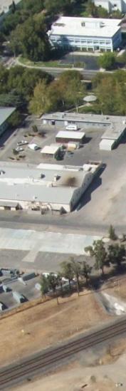
3 Watt Avenue at Roseville Road Pedestrian and Bicycle Access Feasibility Study April 12, Introduction and Project Location The County of Sacramento Department of Transportation by way of this study considers the feasibility of various alternatives for creating a continuous north-south walk and bikeway through the area of the Union Pacific Railroad (UPRR) underpass on or adjacent to Watt Avenue and north of Roseville Road in Sacramento County. Both UPRR and Sacramento County have identified safety issues within the area of the existing Watt Avenue underpass. The UPRR rail corridor at this location is heavily used and provides service for both UPRR freight and the Capitol Corridor Intercity Rail. The Capitol Corridor is a 170-mile passenger train corridor from Auburn and Sacramento to San Jose with a daily ridership of approximately 3,500 passengers. The tracks over Watt Avenue connect the Roseville and Sacramento stations on the Capitol Corridor line. North Figure 1: Aerial view of the Watt Ave/UPRR Grade Separation 2. Description of Existing Facilities The existing Watt Avenue UPRR underpass is a two-span, double track, ballasted, riveted steel through plate girder, with the tracks spaced approximately 14-0 center-to-center. It is located within the UPRR Roseville Division, Martinez Subdivision at Mile Post (MP) 98.33; a segment of the track originally constructed by the Central Pacific Railroad in about 1864 and becoming a part of the UPRR in September 1996 when the UP acquired the Southern Pacific Railroad. The minimum vertical clearance over Watt Avenue to the UPRR underpass structure is approximately Watt Avenue is a major north-south thoroughfare in Sacramento County with a posted speed limit of 35 miles per hour. Watt Avenue carries three lanes of traffic in both the northbound and southbound directions as it passes under the UPRR tracks. The horizontal clearance through the structure is constrained by the existing underpass abutments and center bent. 2


4 Watt Avenue at Roseville Road Pedestrian and Bicycle Access Feasibility Study April 12, 2010 The original underpass was constructed in the 1950 s as a single span structure over the existing two lane Watt Avenue; one lane of traffic in each direction. At that time the structure provided approximately 31-4 of horizontal clearance between the faces of the abutments. Watt Avenue was widened in 1972 to provide three lanes of traffic in each direction. The original roadway was converted to southbound traffic only, with an added lane for a total of three (3) lanes now under the original span. The east abutment was converted to become the center bent in order to support a new easterly span accommodating the three lanes of Watt Figure 2: Existing Watt Ave UP looking to South Avenue. Currently, the horizontal clearance for the northbound lanes is approximately 34-6 ; while the southbound traffic remains at about 31-4 face to face of structure. The constrained horizontal clearance does not provide adequate clearance to include sidewalks or bike lane striping along Watt Avenue. Currently, pedestrian and bicycle traffic along Watt Avenue must use the existing corrugated metal pipe (CMP) ped/bike underpass located to the west of the Watt Avenue [see photos of the west entrance to the CMP in Figure 3]. Access to the CMP underpass is over 150 west of Watt Avenue and obstructed from view making visibility of the pathway limited; isolating users and creating a security problem for those users. Figure 3: Entrance to the existing CMP ped/bike underpass It is not unusual to see cyclists crossing directly over the active UPRR tracks or traversing the UPRR underpass with the vehicular traffic rather than use the CMP underpass [see Figure 3]. Figure 4: Cyclists avoiding the CMP underpass are a significant safety concern 3

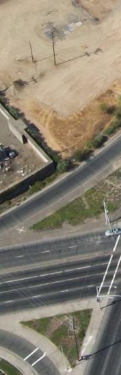
5 Watt Avenue at Roseville Road Pedestrian and Bicycle Access Feasibility Study April 12, Purpose and Need Sacramento County has identified the Watt Avenue Underpass as a choke point within this major transportation corridor and would like to widen Watt Avenue in the future to eliminate the constrained vehicular movements, while accommodating safe passage for bicycles and pedestrians on both sides of Watt. Although this widening is desirable and within the planning horizon, there is no funding currently identified. While experienced urban cyclists can legally occupy the travelled way with motor vehicles, the speed and volume of the traffic, coupled with the reduced lane and shoulder widths through the underpass makes use of the Watt Avenue Underpass by bike users very undesirable. Pedestrians proceeding north or south along Watt Avenue must use the previously described CMP underpass on the west side of the corridor or detour to the east and cross the UPRR tracks on the Airbase Drive Overhead, adding approximately ½ mile to their trip. While the approaches to the CMP underpass are isolated and have restricted visibility, resulting in security and safety concerns The Airbase Drive route is not an efficient route for either north or south bound pedestrian and bicycle movements making it inconvenient to use. Indeed users that are unfamiliar with the area would not necessarily even be aware of the choice to use the CMP to the west or Airbase Drive to the east. North Figure 5: A few of the frequently used alternate dangerous routes taken by pedestrians and cyclists across UPRR tracks are in proximity to the skull & cross bones symbols. These conditions have resulted in frustrated and impatient pedestrian and bicycle users trespassing on the UPRR right-of-way (ROW) in order to climb the railroad embankment and cross the active tracks atgrade. Such illegal at-grade crossings of the tracks can have grave consequences for both trespasser(s) and the freight and passenger trains using the tracks. The pedestrian and bicycle crossings are frequent enough that paths across the tracks are visible in the aerial photo shown in Figure 5: above identified by the skull & crossbones symbols. Sacramento County is investigating options to provide safe passage for both pedestrians and bicyclists through the Watt Avenue Underpass area which will alleviate safety issues resulting from the frequent illegal at-grade crossings of the UPRR tracks at Watt Avenue. Providing facilities to grade separate the 4

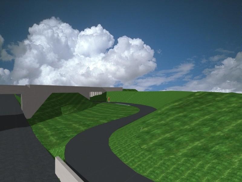
6 Watt Avenue at Roseville Road Pedestrian and Bicycle Access Feasibility Study pedestrian and bicycle movements and the UPRR tracks at Watt Avenue will also encourage more people to walk and bike along this critical segment of Watt Avenue once it is safer to do so. 4. Pedestrian Grade Separated Crossings: Over or Under April 12, 2010 The effectiveness of grade separated crossings depends heavily upon whether or not the users perceive the facility accessibility and ease of use. Often times it is perceived to be more efficient to cross at grade rather than to use the grade separated crossing. Users weigh the perceived safety benefits against effort and time issues. To maximize the use of grade separated crossings, they should be located in the normal or expected path of major pedestrian and bicycle user movements. Pedestrians almost always favor the shortest route; therefor, a facility that is inconvenient to access or is on an indirect path will simply not be used. The most direct and effective separation would be achieved by the addition of dedicated pedestrian and bicycle pathways directly adjacent to the travelled way along Watt Avenue; however, this would require replacement of the existing underpass, which although desirable this would be a much longer term solution due to its expense and current funding sources. The goal of this study was to also identify short term or intermediate options. We are then left with two options: 1) go over the tracks, or 2) go under the tracks. Recalling the convenience principle and considering the fact that the tracks are located on an elevated embankment, a pedestrian path over the tracks would have to rise almost 40 feet in the air to provide the required vertical clearance over the UPRR (23-6 : top of rail to low structure element). Users would need to ascend the height by use of stairs, an elevator or lengthy ramps that would have to accommodate users with limited mobility. Climbing up stairs or a ramp the equivalent height of a four story building would challenge the convenience test for most pedestrians; although, the ramps would present an inviting challenge to skateboard enthusiasts; therefore, this option of going over the tracks with a ped/bike path is not a desirable consideration. With tracks on an elevated embankment, going under or an underpass type of grade separated crossing reduces the required elevation climb of the users. The underpass type facility works best when designed to feel open, well-lit and safe. Security for users may be a concern if the facility is isolated or obstructed from view, such as the existing culvert crossing; however, this can be minimized with our proposed alternative (see Figure 6.).. 5. Proposed Alternatives Sacramento County s preferred proposed alternative is to construct pedestrian and bike access along Watt Avenue with grade separated crossings under the UPRR tracks. The paved mixed use pedestrian/bike paths will be located adjacent to and provide access for both the east and west sides of Watt Avenue. The existing cut slopes along Watt Avenue will be re-graded to provide unobstructed views of the pedestrian and bike underpass. The path will curve away from Watt Avenue and cross under the UPRR tracks behind the existing wingwalls, at an angle perpendicular to the tracks to minimize the length and complexity of the structure required to carry the UPRR tracks over the Figure 6: Conceptual view of ped/bike path from path. The approach path to the proposed ped/bike Northbound Watt Ave underpass structure and the retaining walls at the entrance of the underpass will be arranged to provide views of the facility from Watt Avenue that are as unobstructed as possible from along the path and from Watt Avenue. 5
7 Watt Avenue at Roseville Road Pedestrian and Bicycle Access Feasibility Study April 12, Discussion of Proposed Structure Type The proposed underpass structures would utilize a UPRR Standard Plan pre-cast (PC), pre-stressed (PS) concrete double cell box girder type structure. Each girder is 7 feet wide, and two girders are placed sideby-side to support a single track. A 34-0 long, single-span arrangement is proposed with the girder ends bearing on UPRR Standard Plan PC concrete end bents, supported by driven H-Piling. Embankment material behind each end bent would be retained by steel sheet piling. The piling supporting the end bents may be enclosed with additional precast concrete panels or a concrete block retaining wall and backfilled with flowable backfill; or some other type of enclosure configured to meet both pathway user safety and railroad design and maintenance requirements A precast concrete fascia beam that will create a 2-6 wide UPRR maintenance walkway and include a chain link fence will be provided on both sides of the deck. The fascia beam with chain link fence will satisfy the protective cover requirements as stated in Section of the BNSF Railway Union Pacific Railroad Guidelines for Railroad Grade Separation Projects. Wingwalls will be constructed from a modular precast concrete wall system [ T-Wall ], arranged to open up the view to the entrance of the path thru the underpass to nearby Watt Avenue. 5.2 Discussion of Proposed Construction Methods and Staging The use of a shoo-fly or temporary track to route the existing rail traffic away from the construction would be prohibitively expensive. A shoo-fly would require substantial embankment and track construction for the approaches to Watt Avenue; a temporary railroad underpass on Watt Ave.; and likely modification of the Watt Ave. roadway profile to accommodate the necessary vertical clearance between Watt and the temporary UPRR underpass structure. The proposed pedestrian/bicycle underpass does not require the use of a shoo-fly because the capital cost of using this approach is expected to be in excess of 60% of the reconstruction of the existing vehicular underpass. As previously stated, no funding is currently identified that could support the replacement. While the use of a shoo-fly is certainly the preferred method of maintaining safe rail operations during construction of any structure to carry trains; the proposed solution can and has been executed safely by others, including the UPRR, in the Sacramento area. The proposed solution would not utilize a shoo-fly to construct the proposed pedestrian/bicycle underpass; rather, it would limit UPRR operations to single track operation while the pedestrian underpass structure is installed under each track, one at a time. Operations would then shift to the other track while the second half of the underpass structure is constructed. The process would require the use of existing crossovers or the installation of new ones to facilitate single track operation. The following describes the anticipated sequence of activities required to construct the underpass structure without the use of a shoo-fly track, while maintaining rail traffic. It is assumed that all the appropriate safety measures required by UPRR have been incorporated by design and field operations are conducted under the watchful eye of trained UPRR flagmen. Stage 1 1. Shift to single track operations (all rail traffic on Track No. 1). 2. Place temporary sheet piling between the existing tracks; remove section of Track No. 2 track; excavate sufficient material to allow installation of piling and precast concrete end bent. 3. Drive the HP piling; cut off piles to receive precast concrete end bents. 4. Place precast concrete end bent on HP piles and complete welded connection. 5. Install sheet pile cut-off walls behind backwall of each PC concrete end bent. 6
8 Watt Avenue at Roseville Road Pedestrian and Bicycle Access Feasibility Study April 12, 2010 Stage 2 1. Excavate track bed between end bents; install PC/PS concrete box girders, PC concrete fascia beams, wingwalls, T-wall units and temporary ballast curb. 2. Backfill behind end bents. 3. Place waterproofing, ballast, and re-install Track No. 2 track. 4. Shift traffic to Track No. 2 track single track operation). Stage 3 1. Remove portion of temporary sheet piling between tracks 2. Remove portion of Track No. 1 track & excavate 3. Drive HP piling 4. Set precast end bents 5. Install sheet pile cut-off walls behind end bents Stage 4 1. Excavate track bed between end bents; install PC/PS concrete box girders, PC concrete fascia beams, wingwalls, T-wall units. 2. Backfill behind end bents. 3. Remove temporary ballast curb. Complete water proofing, place ballast and reinstall track 4. Remove remaining temporary sheet piling between tracks; fill any voids with flowable backfill or grout 5. Resume double track operations Stage 5 1. Excavate beneath installed concrete girders 2. Construct retaining wall in front of piling at each end bent 3. Place flowable backfill behind retaining wall 4. Construct paved pedestrian/bicycle path 5. Install chain link fence 6. UPRR Review Sacramento County is anticipating partnering with UPRR in the construction of this project. It will be necessary to develop a Memorandum of Understanding (MOU) that details cost share and responsibilities prior to the commencement of any project. In order to minimize impacts to UPRR operations, Sacramento County proposes that the construction of the underpass structure be performed by a UPRR contractor. The approaches to, and the pedestrian/bike path through the underpass structure would be constructed by a Sacramento County contractor. The viability of this project is contingent upon the agreement of UPRR to allow the pedestrian/bike grade separation underpass structures to be built in stages. 7
9 Watt Avenue at Roseville Road Pedestrian and Bicycle Access Feasibility Study April 12, Preliminary Drawings 7.1 Combined General Plan 7.2 East Crossing General Plan 7.21 East Crossing Plan & Pump House Detail 7.22 Pathway Perspective 7.3 West Crossing General Plan 7.4 Stage 1 Plan 7.5 Stage 2 Plan 7.6 Stage 3 Plan 7.7 Stage 4 Plan 7.8 Stage 5 Plan 7.9 Advanced Planning Underpass Replacement With Third UP Rail 8. Schedules and Cost Estimates Design Schedule of East and or West Crossings Construction Schedule of East and or West Crossings Construction Cost Estimate of East and or West Crossings 9. Supplemental Documents AECom Comments Regarding Underpass Replacement Costs Final Invoice & Project Status Summary 8
10 WATT AVENUE AT ROSEVILLE ROAD PEDESTRIAN & BICYCLE ACCESS IMPROVEMENTS LAYOUT
11 WATT AVENUE AT ROSEVILLE ROAD PEDESTRIAN & BICYCLE ACCESS IMPROVEMENTS GENERAL PLAN - EAST CROSSING
12 DRAFT - NOT FOR CONSTRUCTION WATT AVENUE AT ROSEVILLE ROAD PEDESTRIAN & BICYCLE ACCESS IMPROVEMENTS PLAN AND PROFILE
13
14 WATT AVENUE AT ROSEVILLE ROAD PEDESTRIAN & BICYCLE ACCESS IMPROVEMENTS GENERAL PLAN - WEST CROSSING
15 WATT AVENUE AT ROSEVILLE ROAD PEDESTRIAN & BICYCLE ACCESS IMPROVEMENTS
16 WATT AVENUE AT ROSEVILLE ROAD PEDESTRIAN & BICYCLE ACCESS IMPROVEMENTS
17 WATT AVENUE AT ROSEVILLE ROAD PEDESTRIAN & BICYCLE ACCESS IMPROVEMENTS
18 WATT AVENUE AT ROSEVILLE ROAD PEDESTRIAN & BICYCLE ACCESS IMPROVEMENTS
19 WATT AVENUE AT ROSEVILLE ROAD PEDESTRIAN & BICYCLE ACCESS IMPROVEMENTS
20 WATT AVENUE UNDERPASS UPRR MP MARTINEZ SUB ADVANCED PLANNING STUDY
21 Draft Project Schedule Design of Watt Ave/Roseville Rd Ped/Bike Access [East Crossing] Tue 5/4/10 ID Task Name Duration Start Finish Predecessors 1 Watt/Roseville Rd Ped/Bike Access Improvements 360 days Tue 5/4/10 Mon 9/19/ Qtr 2 Qtr 3 Qtr 4 Qtr 1 Qtr 2 Qtr 3 2 Concept Level Design 2 mons Tue 5/4/10 Mon 6/28/10 3 UPRR Review/Approval of Concept 1 mon Tue 6/29/10 Mon 7/26/ Project Description 0.5 mons Tue 7/27/10 Mon 8/9/ CEQA/NEPA Environmental Process 8 mons Tue 8/10/10 Mon 3/21/ % Design [Type Selection, Const Staging, etc.] 3 mons Tue 7/27/10 Mon 10/18/ Internal QA/QC Process/Prepare submital 0.25 mons Tue 10/19/10 Mon 10/25/ UPRR Review/Approval of 35% Design 1 mon Tue 10/26/10 Mon 11/22/ Response to UPRR Comments on 35% Design 0.5 mons Tue 11/23/10 Mon 12/6/ % Design [Response to comments, etc.] 3 mons Tue 11/23/10 Mon 2/14/ Internal QA/QC Process/Prepare submital 0.25 mons Tue 2/15/11 Mon 2/21/ UPRR Review/Approval of 65% Design 1 mon Tue 2/22/11 Mon 3/21/ Response to UPRR Comments on 65% Design 0.5 mons Tue 3/22/11 Mon 4/4/ Final Design [PS&E, Bid Documents, etc.] 3 mons Tue 4/5/11 Mon 6/27/11 5,12,13 15 Advertise/Bid/Award 3 mons Tue 6/28/11 Mon 9/19/11 14 Project: Watt-RosevillePed_Bike_0504 Date: Tue 5/4/10 Task Split Progress Milestone Summary Project Summary External Tasks External Milestone Deadline Page 1
22 Draft Project Schedule Construction of Watt Ave/Roseville Rd Ped/Bike Access [East Crossing] Tue 5/4/10 ID Task Name Duration Start Finish Predecessors 1 Construct Watt/Roseville Ped/Bike Access [East Crossing] 128 days Tue 5/4/10 Thu 10/28/10 2 Construct Ped/Bike Underpass Structure 43 days Tue 5/4/10 Thu 7/1/10 3 Modifications required to permit single track operations 20 days Tue 5/4/10 Mon 5/31/10 4 Stage I 5.5 days Tue 6/1/10 Tue 6/8/10 5 Shift to single track operation 1 day Tue 6/1/10 Tue 6/1/ Place temp sheet piling between tracks 1 day Wed 6/2/10 Wed 6/2/ Remove No. 2 track & excavate for PC end bent 0.5 days Thu 6/3/10 Thu 6/3/ Drive HP piling supports = 4 piles/end bent 2 days Thu 6/3/10 Mon 6/7/ Install PC end bents and permanent sheet pile cut-off 1 day Mon 6/7/10 Tue 6/8/ Stage II 5.75 days Tue 6/8/10 Wed 6/16/10 11 Excavate remaining track bed between end bent 0.25 days Tue 6/8/10 Tue 6/8/ Install PC/PS concrete box girders and components 2 days Tue 6/8/10 Thu 6/10/ Backfill behind end bent 0.5 days Thu 6/10/10 Fri 6/11/ Install waterproofing, temp ballast curb 1 day Fri 6/11/10 Mon 6/14/ Reconstruct No. 2 Track 1 day Mon 6/14/10 Tue 6/15/ Shift single track operation to No. 2 Track 1 day Tue 6/15/10 Wed 6/16/ Stage III 5 days Wed 6/16/10 Wed 6/23/10 18 Remove portion of temp sheet piling between tracks 0.5 days Wed 6/16/10 Wed 6/16/ Remove No. 1 track & excavate for PC end bent 0.5 days Wed 6/16/10 Thu 6/17/ Drive HP piling supports = 4 piles/end bent 2 days Thu 6/17/10 Mon 6/21/ Install PC end bents and permanent sheet pile cut-off 2 days Mon 6/21/10 Wed 6/23/ Stage IV 6.75 days Wed 6/23/10 Thu 7/1/10 23 Excavate remaining track bed between abutment 0.25 days Wed 6/23/10 Wed 6/23/ Install PC/PS concrete box girders and components 2 days Wed 6/23/10 Fri 6/25/ Backfill behind end bent 0.5 days Fri 6/25/10 Fri 6/25/ Remove temp ballast curb, install waterproofing, & ballast 1 day Mon 6/28/10 Mon 6/28/ Reconstruct No. 1 Track 1 day Tue 6/29/10 Tue 6/29/ Remove sheet piling from between tracks; grout voids 1 day Wed 6/30/10 Wed 6/30/ Return to double track operation 1 day Thu 7/1/10 Thu 7/1/ Construct Ped/Bike Path and Approaches 85 days Fri 7/2/10 Thu 10/28/10 31 Construction Area signs/traffic Control 5 days Fri 7/2/10 Thu 7/8/ Complete excavation of underpass 5 days Fri 7/9/10 Thu 7/15/ Approach pathway grading and embankment 20 days Fri 7/9/10 Thu 8/5/ Construct retention/closure system in front of end bents 15 days Fri 7/16/10 Thu 8/5/ Install soil nail/tieback retention system at pump station 20 days Fri 8/6/10 Thu 9/2/ Install path underground utilities: electrical, irrigation, etc. 15 days Fri 9/3/10 Thu 9/23/10 33,34,35 37 Pave path and construct link to existing facilities 5 days Fri 9/24/10 Thu 9/30/ Landscaping, irrigation, lighting 20 days Fri 10/1/10 Thu 10/28/ Fencing, railing, misc site work 10 days Fri 10/8/10 Thu 10/21/10 38SS+5 days 40 Cleanup 5 days Fri 10/22/10 Thu 10/28/10 39 April May June July August September October November 3/28 4/4 4/11 4/18 4/25 5/2 5/9 5/16 5/23 5/30 6/6 6/13 6/20 6/27 7/4 7/11 7/18 7/25 8/1 8/8 8/15 8/22 8/29 9/5 9/12 9/19 9/26 10/3 0/1 0/1 0/2 0/3 11/7 1/1 Project: Watt-RosevillePed_Bike_0504 Date: Tue 5/4/10 Task Split Progress Milestone Summary Project Summary External Tasks External Milestone Deadline Page 1
23 GENERAL PLAN ESTIMATE X ADVANCE PLANNING ESTIMATE RCVD BY: IN EST: OUT EST: BRIDGE: Watt Ave/Roseville Rd Ped/Bike Access [East Crossing] BR. No.: DISTRICT: TYPE: PC/PS Dbl Cell Box Girder with Exterior Fascia Beams RTE: CU: NA CO: EA: NA PM: LENGTH: WIDTH: AREA (SF) = 1,207 DESIGN SECTION: AECOM # OF STRUCTURES IN PROJECT : 01 EST. NO. 1 PRICES BY : T. Barnard COST INDEX: NA QUANTITIES BY: DATE: 4/1/2010 QUANTITIES CHECKED BY: DATE: CONTRACT ITEMS TYPE UNIT QUANTITY PRICE AMOUNT 1 Construction Area Signs LS 1 $5, $5, Traffic Control LS 1 $15, $15, Railroad Flagging per Day EA 25 $ $20, Storm Water Polution Control LS 1 $7, $7, Path Excavation/Rough Grading CY 2,500 $30.00 $75, Remove/Reconstruct Track LF 120 $ $24, Tie Back Retaining Pump Station SF 480 $85.00 $40, Class 2 Agg Base - Path Subgrade CY 900 $60.00 $54, Hot Mix Asphalt [HMA] Concrete Ton 300 $95.00 $28, T-Wall Retention System SF 1,000 $65.00 $65, Temporary Sheet Piling SF 1,500 $40.00 $60, Permanent Sheet Piling SF 900 $65.00 $58, PC/PS Box Girder UP [2 34ft ea includes fascia bm] LF 68 $5, $374, Waterproofing & Deck Drainage System SF 1,020 $20.00 $20, Landscaping & Irrigation LS 1 $60, $60, Lighting LS 1 $20, $20, SUBTOTAL $927,700 ROUTING MOBILIZATION 10 % ) $92, DES SECTION SUBTOTAL ITEMS $1,020,470 CONTINGENCIES (@ 25%) $255,118 TOTAL COST $1,275,588 GRAND TOTAL $1,275,588 FOR BUDGET PURPOSES - SAY $1,280,000 COMMENTS: Cost for utility relocations not included.
24 AECOM Comments Regarding Cost and Schedule Considerations for the total replacement of the UP Underpass Structure AECom estimates that the replacement of the existing underpass structure will likely take a minimum of months for construction. The primary driver will be staging the construction so the disruption to vehicular and rail traffic is minimized. Currently, there are three lanes that choke down to two at Peacekeeper in the northbound. Maintaining 2 lanes in each direction thru construction may require a local detour to the east in order to allow the profile of Watt to be lowered for permanent clearance to be achieved. AECom considers it likely that UP will require a double track shoofly and that will require a temporary UP structure to carry the shoofly tracks through the work zone. Signal work within the area to support the shoofly would need to take place in advance of the shift of rail traffic and is usually a long lead item with UP. AECom provides a rough estimate of the construction price at around $15 $20K/LF per track or $13.5M $18M for the railroad structure; another $4 5M for the temporary shoofly track and structures and another $8M $12M for the roadway detours and permanent improvements. A grand total estimate of around $35M $40M for the replacement.
section 4 Existing Conditions, Issues, and Options
 section 4 Existing Conditions, Issues, and Options 4.0 Existing Conditions, Issues, and Options This section analyzes each segment of the corridor on a street to street basis. Each segment is discussed
Hospital Link Project Project Update September 2017
 Hospital Link Project Project Update September 2017 General The project provides a link from Riverside Drive and the Transitway to the Hospital Link Road. Construction is well underway. Read on for important
Design Criteria. Design Criteria
 F Design Criteria Design Criteria Ministry of Transportation Ministère des Transports DESIGN CRITERIA Page: 1 of 13 WORK PROJECT NO. N/A GO Bloomington Station TYPE OF PROJECT LOCATION Bloomington Road
American Railway Engineering and Maintenance of Way Association Letter Ballot. Draft
 American Railway Engineering and Maintenance of Way Association Letter Ballot 1. Committee and Subcommittee: Committee 5 Track Subcommittee 9 Road Crossings 2. Letter Ballot Number: 05-17-16 3. Assignment:
General Design Factors
 Chapter 3: 3-1.0 Introduction General Design Factors Mn/DOT s goals include encouraging and accommodating safe bicycling. From a design perspective, these goals are achieved by first having an understanding
City of Roseville Section 13 Design Standards. _Bikeways January 2016 SECTION 13 BIKEWAYS
 SECTION 13 BIKEWAYS 13-1 GENERAL The City of Roseville bikeway standards are designed to insure that transportation and recreational bikeways are constructed in a manner that would provide a safe and comfortable
Hospital Link Project Project Update November 2017
 Hospital Link Project Project Update November 2017 General The project provides a link from Riverside Drive and the Transitway to the Hospital Link Road. Construction is well underway. Read on for important
CURBSIDE ACTIVITY DESIGN
 5 CURBSIDE ACTIVITY DESIGN This chapter provides design guidance for separated bike lanes adjacent to curbside activities including parking, loading and bus stops. Typical configurations are presented
FY 2006 TRANSPORTATION CAPITAL PROGRAM
 Eden Lane Bridge over Whippany River NS9908 The existing structure was built in 1972 as a temporary single-span structure. The bridge consists of simply supported steel acrow panel trusses and is supported
DRAFT. A fifth objective, other considerations, has been added to capture considerations not captured by the four primary objectives.
 TECHNICAL MEMORANDUM Albany - Washington Avenue Traffic Calming Evaluation Matrix of Conceptual Alternatives Date: May 17, 2017 Project #: 17356 To: Aleida Andrino-Chavez From: Laurence Lewis, Sara Muse,
Agenda Item # Page # RECOMMENDATION
 TO: FROM: SUBJECT: CHAIR AND MEMBERS CIVIC WORKS COMMITTEE MEETING ON FEBRUARY 2, 2016 JOHN BRAAM, P. ENG. MANAGING DIRECTOR, ENVIRONMENTAL & ENGINEERING SERVICES AND CITY ENGINEER FIELD MARSHAL WOLSELEY
Item No. 14 Town of Atherton
 Item No. 14 Town of Atherton CITY COUNCIL STAFF REPORT CONSENT AGENDA TO: THROUGH: FROM: HONORABLE MAYOR AND CITY COUNCIL GEORGE RODERICKS, CITY MANAGER MICHAEL KASHIWAGI, COMMUNITY SERVICES DIRECTOR MARTY
Poor pavement condition Substandard Intersections. / Substandard bike/pedestrian/transit accommodations. Driveway access Environmental concerns
 Public Informational Meeting University Avenue (Allen Boulevard Segoe Road) March 23, 2011 City of Madison City of Middleton Village of Shorewood Hills Dane County Existing Roadway Conditions Poor pavement
CHAPTER 16 PEDESTRIAN FACILITIES DESIGN AND TECHNICAL CRITERIA TABLE OF CONTENTS
 CHAPTER 16 PEDESTRIAN FACILITIES DESIGN AND TECHNICAL CRITERIA TABLE OF CONTENTS Section Title Page 16.1 General... 16-1 16.1.1 AASHTO Reference... 16-1 16.1.2 ADA Requirements... 16-1 16.2 Sidewalks...
4. TRAIL DESIGN GUIDELINES
 Trail Design Guidelines 4. TRAIL DESIGN GUIDELINES This chapter provides specific design guidelines for the Humboldt Bay Trail that are consistent with the guidelines currently observed in California and
CITY OF WOODINVILLE ONGOING CAPITAL IMPROVEMENT PROJECT UPDATES
 CITY OF WOODINVILLE ONGOING CAPITAL IMPROVEMENT PROJECT UPDATES PROJECT LOCATION MAP (1) DEYOUNG PARK IMPROVEMENTS Project Description - DeYoung Park Improvements include treehouse deck, play area, new
Municipal Class EA To Address Traffic Congestion On The Ontario Street Corridor (Grand Bend) Public Information Meeting June 4, 2018
 Public Information Meeting June 4, 2018") Municipal Class EA To Address Traffic Congestion On The Ontario Street Corridor (Grand Bend) Public Information Meeting June 4, 2018 Background Agenda Traffic Study Update Class EA Alternatives Bridge
Municipal Class EA To Address Traffic Congestion On The Ontario Street Corridor (Grand Bend) Public Information Meeting June 4, 2018 Background Agenda Traffic Study Update Class EA Alternatives Bridge
Non-Motorized Overpass at SR 5/US1
 Non-Motorized Overpass at SR 5/US1 And SR 97/SW th Street (Bird Road) Executive Summary March 9, 17 Prepared By: MARLIN Engineering Inc 17 NW th Avenue, Ste. 1 Plantation, FL 33313 P: 35.77.7575 www.marlinengineering.com
US 19 Pedestrian and Bicycle Safe Access to Transit Corridor Study
 US 19 Pedestrian and Bicycle Safe Access to Transit Corridor Study DRAFT Technical Memorandum #6 Cost and Benefit Evaluation Methodology August 2016 Prepared for: FLORIDA DEPARTMENT OF TRANSPORTATION DISTRICT
SAWS QA/QC CHECKLIST WATER ADJUSTMENT/RELOCATION PROJECTS
 SAWS QA/QC CHECKLIST WATER ADJUSTMENT/RELOCATION PROJECTS Project Name: SAWS Water Job No.: CSJ No. (if applicable): Date: AWS Consultant: PROJECT INFORMATION N/A Yes No Joint Bid (COSA/TxDOT) N/A Yes
SECTION TRAFFIC REGULATIONS
 SECTION 01550 TRAFFIC REGULATIONS PART 1 - GENERAL 1.01 OBJECTIVES A. The Contractor shall provide for safe movement of vehicular, bicycle and pedestrian traffic, including persons with disabilities in
5. RUNNINGWAY GUIDELINES
 5. RUNNINGWAY GUIDELINES These guidelines should be considered collectively when making runningway decisions. A runningway is the linear component of the transit system that forms the right-of-way reserved
Accommodating Pedestrians in the Work Zone
 Accommodating Pedestrians in the Work Zone Guidance for Section C Plan Preparers Some impacts cannot be avoided and those impacts apply to residents, businesses, motorists, and pedestrians alike. However,
Paul Huston, P.E., Design-Build Coordinator Chuck Gonderinger, HDR Engineering. Minnesota Department of Transportation (the Department)
") To: From: Paul Huston, P.E., Design-Build Coordinator Chuck Gonderinger, HDR Engineering Date: March 20, 2001 Subject: Roadway Geometric Design Criteria Project: TH 14/218 Design-Build Project, SP 7408-29,
To: From: Paul Huston, P.E., Design-Build Coordinator Chuck Gonderinger, HDR Engineering Date: March 20, 2001 Subject: Roadway Geometric Design Criteria Project: TH 14/218 Design-Build Project, SP 7408-29,
Replacement of N. Carlin Springs Road Bridge over George Mason Dr.
 Replacement of N. Carlin Springs Road Bridge over George Mason Dr. Approximate schedule with phases and proposed Maintenance of Travel (MOT) plans February 2017 Project Elements Removal of existing bridge
Shared Use Path Design
 12B-2 Design Manual Chapter 12 - Sidewalks and Bicycle Facilities 12B - Bicycle Facilities Shared Use Path Design A. Accessible Shared Use Path Design 1. General: Applicable portions from the following
Table 1.0 Grade Crossing Enhancements PVL San Jacinto Branch Line
 Grade Crossing Enhancements CPUC 1 2 3 4 5 Citrus Avenue, Riverside County Palmyrita Ave., Columbia Avenue, Marlborough Ave., Spruce St., MP 0.57 002X-0.6 027301Y MP 1.00 002X-1.0 027302F MP 1.24 002X-1.3
Alberta Infrastructure HIGHWAY GEOMETRIC DESIGN GUIDE AUGUST 1999
 Alberta Infrastructure HIGHWAY GEOMETRIC DESIGN GUIDE AUGUST 1999,1'(; A ACCELERATION Data on acceleration from stop D-29 Effects of grade D-35 Intersections D-97, D-99 Lanes D-97, F-5, F-7, F-15, F-21,
Appendix T CCMP TRAIL TRAFFIC & TRANSPORTATION DESIGN STANDARD
 Appendix T CCMP 3.3.4 TRAIL TRAFFIC & TRANSPORTATION DESIGN STANDARD 3.3.4 Trail Traffic and Transportation Design Multi-use trails have certain design standards, which vary depending on the agency that
INGHAM COUNTY ROAD DEPARTMENT AUSTIN E. CAVANAUGH ADMINISTRATION BUILDING 301 Bush Street, P.O. Box 38, Mason, MI
 INGHAM COUNTY ROAD DEPARTMENT AUSTIN E. CAVANAUGH ADMINISTRATION BUILDING 301 Bush Street, P.O. Box 38, Mason, MI 48854-0038 March 27, 2018 William M. Conklin, P.E. Managing Director FOR IMMEDIATE RELEASE:
BRIDGE REPLACEMENT AND REHABILITATION PROGRAM
 BRIDGE REPLACEMENT AND REHABILITATION PROGRAM INTRODUCTION An integral element of the City's transportation infrastructure is a network of bridges designed to carry vehicular, railroad, light rail, pedestrian,
10 th STREET BRIDGE REPLACEMENT Schedule 'C' EA: Phase 3 Presentation to Council Recommended Design Alternatives City of Owen Sound August 27, 2018
 10 th STREET BRIDGE REPLACEMENT Schedule 'C' EA: Phase 3 Presentation to Council Recommended Design Alternatives City of Owen Sound August 27, 2018 May 2015 1 AGENDA 1. Overview of Municipal Class EA Process.
APPENDIX L. Design Criteria
 APPENDIX L Design Criteria DRAFT PRELIMINARY DESIGN CRITERIA Page 1 of 18 APPROVALS MANAGER, ENGINEERING CITY OF HAMILTON MANAGER, ENGINEERING REGION OF HALTON DATE This Design Criteria for the New East-West
Design of Stanley Park S-Curve
 ADMINISTRATIVE REPORT Date: May 4, 2001 TO: FROM: Author/Local: F. Klotzbach/7118 RTS NO. 01644 CC File No. Standing Committee on Transportation and Traffic General Manager of Engineering Services, in
ADA on Construction. Guidance for Section C Plan Preparers
 ADA on Construction Guidance for Section C Plan Preparers Some impacts cannot be avoided and those impacts apply to residents, businesses, motorists, and pedestrians alike. However, good planning can minimize
RZC Appendix 8A Marymoor Subarea Street Requirements
 RZC Appendix 8A Marymoor Subarea Street Requirements For additional design details for Marymoor Subarea infrastructure, refer to the 2017 Marymoor Subarea Infrastructure Planning Report. STREET REQUIREMENTS
Designing with the Railroad
 Designing with the Railroad 23 CFR 646.214 (b)(2) requires that crossings be evaluated when they are within limits or near terminus of Federally Funded project. Some rough numbers for planning: Active
IMPLEMENTATION WORKBOOK
 Lawrence Township Bicycle and Pedestrian Planning Assistance Study IMPLEMENTATION WORKBOOK Final Action Plan - Part 2 April 2009 Prepared For: The Township of Lawrence and the New Jersey Department of
Appendix K Pedestrian Bridge Feasibility Report. Rehabilitation and Restoration of the Longfellow Bridge
 Appendix K Pedestrian Bridge Feasibility Report Rehabilitation and Restoration of the Longfellow Bridge Pedestrian Bridge Feasibility Report Longfellow Bridge Rehabilitation and Restoration Boston, Massachusetts
Bids MAY 24, 2018 AT 2:00 P.M. (EASTERN) (Estimated Cost: $7,500,000.00)
 (Estimated Cost: $7,500,000.00)") General Info Number: PROJECT NO. 43-18-02 Description: BRIDGE DECK REPAIR AND REHABILITATION PERRYSBURG-HOLLAND ROAD OVER THE OHIO TURNPIKE, M.P. 59.0 HESSVILLE ROAD OVER THE OHIO TURNPIKE, M.P. 84.4 LUCAS
General Info Number: PROJECT NO. 43-18-02 Description: BRIDGE DECK REPAIR AND REHABILITATION PERRYSBURG-HOLLAND ROAD OVER THE OHIO TURNPIKE, M.P. 59.0 HESSVILLE ROAD OVER THE OHIO TURNPIKE, M.P. 84.4 LUCAS
Saskatchewan Drive Roadway Rehabilitation and Shared-Use Path Widening
 Saskatchewan Drive Roadway Rehabilitation and Shared-Use Path Widening We are here today to present the draft plan for the Saskatchewan Drive Roadway Rehabilitation and Shared-Use Path Widening project
Washington St. Corridor Study
 FIGURE 7.17 Bridge Alternatives - Cross Sections 86 Discarded Alternative: Short-Term Bridge Repair Short-term repairs and west bridge span replacement were considered during analysis. Short-term repairs
Readington Road (C.R. 637) Construction
 Construction") Public Information Meeting Thursday, August 2, 2012 Readington Road (C.R. 637) Construction from Dreahook Road to Harlan School Road Branchburg Township, Somerset County Readington Township, Hunterdon
Public Information Meeting Thursday, August 2, 2012 Readington Road (C.R. 637) Construction from Dreahook Road to Harlan School Road Branchburg Township, Somerset County Readington Township, Hunterdon
INDOT Complete Streets Guideline & Policy
 INDOT Complete Streets Guideline & Policy INTRODUCTION The Complete Streets guidelines build upon multiple efforts and promote a multimodal transportation system that is integrated and sustains land use
NOTICE OF PREPARATION. Environmental Programs 3331 North First Street, Building B-2 San Jose, CA
 NOTICE OF PREPARATION May 29, 2018 To: Reviewing Agencies and Organizations From: Santa Clara Valley Transportation Authority Environmental Programs 3331 North First Street, Building B-2 San Jose, CA 95134-1927
Rio Intersection Traffic Restrictions Begin Monday
 May 18, 2016 8 Rio Intersection Traffic Restrictions Begin Monday This special edition of the Route 29 Solutions e mail newsletter includes everything you need to know about the May 23 through September
TRANSPORTATION COMMISSION Agenda Staff Report
 TRANSPORTATION COMMISSION Agenda Staff Report Agenda Item No. 5.a DATE: JULY 31, 2014 TO: FROM: SUBJECT: TRANSPORTATION COMMISSION COMMUNITY DEVELOPMENT DEPARTMENT - PLANNING DRAFT OLYMPIC CORRIDOR PREFERRED
Chapter 3 DESIGN SPECIFICATIONS
 Brampton PathWays Planning and Design Guidelines 27 Chapter 3 DESIGN SPECIFICATIONS 3.1 CLASS 1 MULTI-USE PATH Off-road multi-use trails are the backbone of the Brampton PathWays Network. They are typically
Blair/Williamson Intersection Expressed Needs
 Blair/Williamson Intersection Expressed Needs NORTH Blair Street is a barrier for pedestrians and bicycles Relocate Capitol City Trail crossing from Blair Street and John Nolen Drive intersection to Williamson
Scarlett Road Bridge & Road Improvements Lambton Park Community School - Gymnasium Tuesday November 28 th, 2017
 Scarlett Road Bridge & Road Improvements Lambton Park Community School - Gymnasium Tuesday November 28 th, 2017 PROJECT LOCATION 2 SCARLETT ROAD BRIDGE Constructed in 1912, the bridge carries 4 active
APPENDIX A Urban Control Zone Corridor Study Reports
 APPENDIX A Urban Control Zone Corridor Study Reports California Sites Table A-1. California Study Corridors California Study Corridor County Name Length (miles) State Highway 1 Orange 7.0 State Highway
FY STATEWIDE TRANSPORTATION IMPROVEMENT PROGRAM New Jersey Department of Transportation Projects
 ROUTE/ Project ID No. TIP No. Electrical Load Center Replacement - North 04324 04324 This project will provide for the betterment of the existing highway lighting facilities located along Routes 3, 17
East Downtown Tax Increment Reinvestment Zone (TIRZ) No. 15 Infrastructure Assessment Study
 No. 15 Infrastructure Assessment Study") East Downtown Tax Increment Reinvestment Zone (TIRZ) No. 15 Infrastructure Assessment Study Houston, TX Technical Memorandum April 15 th, 2009 Prepare by: 2950 North Loop West, Ste. 900 Houston, TX 77092
East Downtown Tax Increment Reinvestment Zone (TIRZ) No. 15 Infrastructure Assessment Study Houston, TX Technical Memorandum April 15 th, 2009 Prepare by: 2950 North Loop West, Ste. 900 Houston, TX 77092
Active Transportation Facility Glossary
 Active Transportation Facility Glossary This document defines different active transportation facilities and suggests appropriate corridor types. Click on a facility type to jump to its definition. Bike
PLACEMENT OF SIGNS RECOMMENDED PRACTICES SUB-SECTION
 Page 1 of 6 RECOMMENDED PRACTICES PART SECTION SUB-SECTION HIGHWAY SIGNS GENERAL General Proper positioning of signs is an important element in the overall control of traffic within a roadway network.
APPENDIX E GRADE CROSSING LOCATIONS
 APPENDIX E GRADE CROSSING LOCATIONS 1 2 3 Citrus Avenue Riverside County and City Palmyrita Avenue Columbia Avenue MP 0.57 002X-0.6 027301Y MP 1.00 002X-1.0 027302F MP 1.24 002X-1.3 027303M 1. Existing
Public Works Committee Meeting Richard E. Mastrangelo Council Chamber November 20, 2017
 Public Works Committee Meeting Richard E. Mastrangelo Council Chamber November 20, 2017 Purpose of Meeting Why are we here? Project Recap/Updates Project Limits/Segments Road Diet Concept Lessons Learned
FY STATEWIDE TRANSPORTATION IMPROVEMENT PROGRAM New Jersey Department of Transportation Projects
 Barclay Street Viaduct NS9807 NS9807 This project will provide for the rehabilitation of the Barclay Street Viaduct, from Route 19 to Marshall Street, in order to increase the weight load of the structure.
APPENDIX A: Complete Streets Checklist DRAFT NOVEMBER 2016
 APPENDIX A: Complete Streets Checklist DRAFT NOVEMBER 2016 Complete Streets Checklist MetroPlan Orlando s Complete Streets Checklist is an internal planning tool for staff to further implementation of
Alexander Ikefuna City of Charlottesville Director of Neighborhood and Development Services
 To: CC: From: Alexander Ikefuna City of Charlottesville Director of Neighborhood and Development Services Jeanette Janiczek, City of Charlottesville UCI Program Manager, NDS Tony Edwards, City of Charlottesville
Military Road Safety Improvements
 Military Road Safety Improvements 26 th Road North to 31 st Street North SUMMARY OF DATA REVIEW AND PRELIMINARY RECOMMENDATIONS Prepared for: Department of Environmental Services Traffic Engineering and
Northside School Class I Bike Path, Cool, CA Application Attachments
 PLHD Grant Application, 12/9/2011 County of El Dorado Department of Transportation Northside School Class I Bike Path, Cool, CA Application Attachments 1. Project Site Map 2. Auburn State Recreation Area
Complete Streets. Designing Streets for Everyone. Sarnia
 Complete Streets Designing Streets for Everyone Sarnia Complete Streets ~ Sarnia ~ 2018 Introduction Our City is made up of a network of streets that we use to go for a walk, cycle to work, drive to the
Route 245 over Broad Run. The recently replaced bridge links The Plains and other communities in northern Fauquier to Interstate 66.
 28 VIRGINIA DEPARTMENT OF TRANSPORTATION \\ CULPEPER DISTRICT Route 245 over Broad Run. The recently replaced bridge links The Plains and other communities in northern Fauquier to Interstate 66. PROJECT
SunPAC Traffic, Circulation, and Parking Goal-Making Matrix
 Applicable 1992 Summerland Community Plan Policies 2009 Recommended SunPAC Polices ROW Policy CIRC-S-18: Existing public rights-of-way shall not be abandoned Policy CIRC S-18: Existing public rights-of-way
700 Multi-Modal Considerations
 700 Multi-Modal Considerations Table of Contents 701 Railroads... 7-1 701.1 Background... 7-1 701.2 Crossing At-Grade... 7-1 701.2.1 General... 7-1 701.2.2 Railroad Parallel to Highway... 7-1 701.3 Lateral
Memorandum. Sunday, July 13, Saturday, July 19, 2014
 Memorandum To: David Lowin, Brooklyn Bridge Park Corporation From: Daniel Schack, AICP, PTP Date: Re: Brooklyn Bridge Park Pier 5/6 Loop Road Traffic Study Project No: 14-01-2407 At the request of Brooklyn
STANDARD SPECIFICATIONS FOR PUBLIC WORKS CONSTRUCTION CITY OF MANITOWOC, WISCONSIN SECTION 900 TRAFFIC CONTROL
 SECTION 900 TRAFFIC CONTROL STANDARD SPECIFICATIONS FOR PUBLIC WORKS CONSTRUCTION CITY OF MANITOWOC, WISCONSIN SECTION 900 TRAFFIC CONTROL Section Number Title 901 GENERAL 902 MATERIALS, EQUIPMENT, AND
Table of Contents. Introduction. Prompt List Arterials and Streets. Prompt List Interchange. Prompt List Intersections. Prompt List Limited Access
 Table of Contents Introduction Prompt List Arterials and Streets Prompt List Interchange Prompt List Intersections Prompt List Limited Access Prompt List MOT Prompt List Pedestrian Bicyclist Prompt List
01. VICINITY OF GREENBRAE POC: EXISTING CONDITIONS
 01. VICINITY OF GREENBRAE POC: EXISTING CONDITIONS Existing Bus Stop Existing US101 On-ramp Existing POC Old Redwood Highway Rich Street City ROW Environmental Study Limit Industrial Way NO DESIGNATED
Building Great Neighbourhoods BELLEVUE AND VIRGINIA PARK
 Building Great Neighbourhoods BELLEVUE AND VIRGINIA PARK This is Meeting 2 Unfortunately, some residents in Bellevue and Virginia Park received the wrong information for this public open house (Meeting
Chapter 4: Funding and Implementation
 Chapter 4: Funding and Implementation 83 84 Cost Estimating Cost estimating is an iterative process. When a project is in the conceptual stage, preliminary cost estimates are also provided conceptually,
SECTION 1A NEW JERSEY TURNPIKE GEOMETRIC DESIGN
 SECTION 1A NEW JERSEY TURNPIKE GEOMETRIC DESIGN Table of Contents Page No 1A.1 GENERAL...1 1A.1.1 DESIGN CONTROLS...1 1A.2 MAINLINE ROADWAYS...4 1A.2.1 ROADWAY DESIGNATION...4 1A.2.2 DESIGN SPEED...4 1A.2.3
Review of Guidelines for Cycleway Safety Fencing
 Review of Guidelines for Cycleway 1.0 PURPOSE 1.1 This document is meant to provide a review of available reference documents for determining appropriate fencing requirements for cycleway paths and shared
Improving Cyclist Safety at the Dundas Street West and Sterling Road Intersection
 STAFF REPORT ACTION REQUIRED Improving Cyclist Safety at the Dundas Street West and Sterling Road Intersection Date: August 17, 2012 To: From: Wards: Reference Number: Public Works and Infrastructure Committee
CITY OF ROHNERT PARK CITY COUNCIL AGENDA REPORT
 Meeting Date: May 10, 2016 Department: Submitted By: Prepared By: Agenda Title: Mission Statement We Care for Our Residents by Working Together to Build a Better Community for Today and Tomorrow. CITY
MAG Town of Cave Creek Bike Study Task 6 Executive Summary and Regional Significance Report
 Page 1 MAG Town of Cave Creek Bike Study Task 6 Executive Summary and Regional Significance Report August 1, 2012 MAG Project #481 Page 2 Task 6 Executive Summary and Regional Significance Report Introduction
Hale iwa Improvement District Project
 Hale iwa Improvement District Project Hale iwa, North Shore, O ahu October 10, 2017 Public Informational Meeting Environmental Impact Statement Preparation Notice Waialua Elementary School 67-020 Waialua
WELCOME! OPEN HOUSE SHAW ROAD IMPROVEMENT PROJECT JUNE 30, 2015
 WELCOME! OPEN HOUSE SHAW ROAD IMPROVEMENT PROJECT JUNE 30, 2015 Traffic Improvements Project Goals Widen roadway to construction two-way left turn lanes-greatly decreases congestion Ease access to & from
Guidance. ATTACHMENT F: Draft Additional Pages for Bicycle Facility Design Toolkit Separated Bike Lanes: Two-Way to One-Way Transitions
 ATTACHMENT F: Draft Additional Pages for Bicycle Facility Design Toolkit Separated Bike Lanes: Two-Way to One-Way Transitions This treatment provides a transition from two-way separated bike lanes to one-way
Welcome to the Open House
 Leslie Street Between 19 th Avenue and Stouffville Road Addendum to Class Environmental Assessment Study Welcome to the Open House Please sign in at the front desk. March 28, 2017 Richmond Green Sports
Environmental Review Binder Documentation McGilchrist Street SE: 12th Street SE to 25th Street SE Project City of Salem, Marion County, Oregon
 Environmental Review Binder Documentation McGilchrist Street SE: 12th Street SE to 25th Street SE Project City of Salem, Marion County, Oregon Updated Project Information (as of August 11, 2017) STIP Project
Montclair s Complete Streets Experience
 Presented by: Hon. Jerry Fried, Mayor Montclair Township About Montclair Six square miles Six commuter rail stations Four local bus routes (NJ Transit) Two private commuter bus routes Five business districts
Project Update May 2018
 Project Update May 2018 Dakota County, in cooperation with the City of Lakeville, is planning to reconstruct 202 nd Street West (County Road 50) from Holyoke Avenue to Cedar Avenue (County Road 23). 202
CHECKLIST 2: PRELIMINARY DESIGN STAGE AUDIT
 CHECKLIST 2: PRELIMINARY DESIGN STAGE AUDIT 2.1 General topics 2.1.1 Changes since previous audit Do the conditions for which the scheme was originally designed still apply? (for example, no changes to
INDEX. Geometric Design Guide for Canadian Roads INDEX
 Acceleration lane, see Lanes, Acceleration Access, 8.1 Access Management and Functional Classification 8.2 Access Management by Design Classification 8.3 Access Configuration 8.4 Building Set-Back Guidelines
Welcome! San Jose Avenue Open House August 25, 2015
 Welcome! San Jose Avenue Open House August 25, 2015 Vision Zero The City and County of San Francisco adopted Vision Zero San Francisco Vision Zero High Injury Network as a policy in 2014, committing an
Construction Specifications Manual
 Isle of Wight County Pedestrian and Bicycle Master Plan Construction Specifications Manual Adopted August 20, 2009 Introduction The Isle of Wight County Pedestrian and Bicycle Facilities Master Plan was
BPP / SUB
 Development Services Department Project/File: Lead Agency: Site address: Millwell Place Subdivision/ BPP15-0031/ SUB15-0064 This is a preliminary plat application to allow for the development of 68 building
OLIVE AVENUE CLASS 2 BIKE LANES HSIP, CIP PROJECT NO CONSTRUCTION CONTRACT AWARD
 STAFF REPORT MEETING DATE: June 7, 2016 TO: FROM: City Council Russ Thompson, Public Works Director Gosia Woodfin, Assistant Engineer 922 Machin Avenue Novato, CA 94945 415/ 899-8900 FAX 415/ 899-8213
On Road Bikeways Part 1: Bicycle Lane Design
 On Road Bikeways Part 1: Bicycle Lane Design Presentation by: Nick Jackson Bill Schultheiss, P.E. September 04, 2012 FOLLOW THE CONVERSATION ON TWITTER Toole Design Group is live tweeting this webinar
Somerville Community Path Feasibility Study
 Somerville Community Path Feasibility Study Prepared for: City of Somerville, Massachusetts Strategic Planning and Community Development July 14, 2006 Prepared by: VOLLMER Table of Contents Section 1.0
The Millbrae Station is owned and operated by the Bay Area Rapid Transit District and is served by Caltrain
 Appendix B Millbrae Station Key features The Millbrae Station is owned and operated by the Bay Area Rapid Transit District and is served by Caltrain and BART, which connects to San Francisco International
CITY OF KASSON TRANSPORTATION ALTERNATIVES KASSON SAFE ROUTES TO SCHOOL
 ve ha 8t G B A Mantorville Ave N 240th Ave 16th St NE 11th Ave NE K-M HIGH SCHOOL SUNRISE TRAIL TO MANTORVILLE MNTH 57 SUNSET TRAIL TO MANTORVILLE NE PARK 16TH ST NE TRAIL K-M ELEMENTARY SCHOOL K-M MIDDLE
New Measure A Expenditure Categories DEFINITIONS OF ELIGIBLE EXPENDITURES Adopted March 8, 2007
 New Measure A Expenditure Categories DEFINITIONS OF ELIGIBLE EXPENDITURES Adopted March 8, 2007 City Street and County Road Maintenance Program The preservation and keeping of public street and road rights-of-way
Detailed Description of Work
 Trail Items I-580 Eastbound Shoulder Running Lane and Bi-Directional Bike Lane Project Bay Area Toll Authority Task Order Contract with HNTB Corporation Effective May 12, 2014 Description of Work: Implement
Downtown Redevelopment Project Update
 Downtown Redevelopment Project Update The redevelopment project will begin the week of September 4, 2017. It is anticipated that construction will be approximately 565 days, depending on weather. 8-1-18
Weymouth - Abington Route 18 Widening and Reconstruction Project File No
 Weymouth - Abington Route 18 Widening and Reconstruction Project File No. 601630 PROJECT LOCATION Project Limit Previously Completed Signalized Intersections (Typical) Route 18 Widening Bridge No. W-32-013
Route 47 (North Main Street) Reconstruction
 Reconstruction") TOWN OF SUNDERLAND Route 47 (North Main Street) Reconstruction Presented by Lou Rabito, P.E. Presented to Town of Sunderland June 11, 2018 Project Overview MassDOT Project No. 607245 Resurfacing and Related
TOWN OF SUNDERLAND Route 47 (North Main Street) Reconstruction Presented by Lou Rabito, P.E. Presented to Town of Sunderland June 11, 2018 Project Overview MassDOT Project No. 607245 Resurfacing and Related
GEARY CORRIDOR BUS RAPID TRANSIT Environmental Analysis. Special Intersections: Preliminary Concepts
 GEARY CORRIDOR BUS RAPID TRANSIT Environmental Analysis Special Intersections: Preliminary Concepts April 2, 2009 FILLMORE: Existing Conditions 3 lanes in underpass, 2 lanes in service road (each direction)