Appendix B. Transportation Analysis. B.1 Summary. East Nassau Employment Center DSAP
|
|
|
- Magdalene Lindsey
- 5 years ago
- Views:
Transcription
1 Appendix B Transportation Analysis B.1 Summary This report presents the transportation analysis completed for the East Nassau Community Planning Area (ENCPA). The ENCPA is defined as 24,000 acres in Nassau County, generally located east of Interstate 95 and north of State Road 200/A1A. The transportation analysis is intended to support the Detailed Special Area Plan (DSAP) submittal to Nassau County. The DSAP requires the following: List of transportation improvements to support development How those improvements will be funded A transportation mobility approach was used to integrate the land use planning for the DSAP with the transportation system to support the area. The benefit of this approach is a more efficient transportation system. The mobility approach promotes the use of transportation options such as walking, bicycling and transit, and employs land use design standards to ensure that these options are viable. The transportation mobility approach accounts for the following elements: Balance of housing and employment Per the approved ENCPA Sector Plan, the overall development program levels were identified to maintain a balance between housing units and employment square footage. In addition to strengthening the employment base for Nassau County, this balance maximizes the internal capture for the ENCPA and reduces impacts on surrounding roadways. Mix of residential and non residential land uses Each of the residential neighborhoods contains non residential land uses such as small scale retail, office, and schools. These uses are located within and adjacent to residential areas, allowing many of these trips to occur by walking or bicycling. The Employment Center and Regional Center areas contain similar requirements for maintaining a mix of uses and incorporating residential and civic uses. Interconnected network of local streets The Sector Plan also provides guidelines for local streets to ensure that they form a connected system between and within neighborhoods. This reduces the need for internal traffic to use the primary street network. B 1 Transportation Analysis
2 Internal trails network The ENCPA is proposed to contain approximately 50 miles of multi use trails that can accommodate pedestrians, bicyclists and golf carts. Within the DSAP area, 10 miles of trails are planned. Transit Oriented Development (TOD) As part of long range plans for the First Coast region, commuter rail connecting Nassau County and downtown Jacksonville has been identified for the CSX and First Coast Railroad corridors. The ENCPA plan incorporates opportunities for TOD along the First Coast Railroad located next to US 17. The remainder of this Appendix addresses the following: Existing Conditions and Level of Service Future Conditions (2035) Baseline Analysis without Project ENCPA Transportation Network and Development Program ENCPA Analysis Results and Recommended Mobility Improvements Employment Center DSAP Recommended Mobility Improvements B.2 Existing Conditions The following is a description of the existing primary roadways in the study area: Interstate 95 generally serves as the western boundary of the ENCPA and connects Nassau County to Duval County to the south and Georgia to the north. Interstate 95 currently has two interchanges within Nassau County that bracket the ENCPA one at US 17 to the south and the other at SR 200/A1A to the south. Interstate 95 currently has six lanes through Nassau County and is under the jurisdiction of FDOT. SR 200/A1A is the primary east west arterial roadway in Nassau County, connecting Interstate 95 to the population centers of Fernandina Beach and Amelia Island to the east. To the west of Interstate 95, SR A1A extends to the rural community of Callahan. SR A1A serves as the southern boundary for the of the Employment Center portion of the DSAP. SR 200 is currently a four lane divided roadway and is under the jurisdiction of FDOT. US 17 is a rural arterial roadway that, similar to Interstate 95, connects Duval County to the south with Georgia to the north. US 17 serves as the eastern boundary for the Employment Center portion of the DSAP. US 17 currently has two lanes through the ENCPA and is under the jurisdiction of FDOT. A rail corridor borders US 17 on the east. Pages Dairy Road is a two lane local roadway that parallels SR A1A between US 17 and Chester Road. The roadway provides access to adjacent residential areas, with some portions of the overall ENCPA fronting directly onto it. Pages Dairy Road is currently a two lane roadway with a rural cross section. The roadway is under the jurisdiction of Nassau County. B 2 Transportation Analysis
3 Chester Road is a local collector roadway that forms the eastern boundary for the overall ENCPA. The roadway extends from SR A1A north to Blackrock Road and intersects with Pages Dairy Road. Chester Road currently has two lanes and is under the jurisdiction of Nassau County. County Road 108 (CR 108) is a rural roadway that extends from US 17 west under Interstate 95 to the town of Hilliard. CR 108 currently has two lanes and is under the jurisdiction of Nassau County. William Burgess Boulevard is a local roadway south of SR A1A that connects US 17 to SR A1A. The Nassau County Courthouse and Florida State College at Jacksonville complexes are located along the corridor. William Burgess Boulevard provides the primary access to the southern portion of the DSAP. William Burgess Boulevard currently has two lanes and is under the jurisdiction of Nassau County. In addition to these primary roadways, other roadway segments were included in the analysis for consistency with the Comprehensive Plan Amendment analysis completed by Nassau County for the ENCPA. Table B 1 summarizes the existing conditions for the study area roadways, including number of lanes, daily volumes and Level of Service (LOS). The traffic counts shown are from FDOT and Nassau County. Table B 1 shows that two segments currently do not meet the County s adopted Level of Service standard for daily conditions: SR A1A from US 17 to Chester Road SR A1A from Chester Road As discussed in the next section, both segments are funded for widening to six lanes within the next five years. It should be noted that Nassau County updated its roadway LOS standards in 2011, utilizing the provisions of HB Although SR A1A is part of the FDOT Strategic Intermodal System, the County is now able to establish the LOS standard for the roadway. The analysis in Table B 1 assumes an Urban Area Type for Interstate 95 and all roads to the east to account for the planned development and urbanization of the area through implementation of the ENCPA. The analysis presented is based on daily conditions instead of peak hour conditions, which is consistent with the mobility approach used by other jurisdictions such as Duval County and Alachua County. B 3 Transportation Analysis
4 Table B 1 Existing Roadway Volumes and Level of Service Nassau Co. FDOT Number of Adopted LOS Service Meets Link ID Count Location Roadway From/To AADT Count Year Lanes Standard Volume (2) Standard? I 95 Duval County Line to SR 200/A1A 59, D D 110,300 Yes 41A I 95 SR 200/A1A to E W Interchange Rd. 47, D D 110,300 Yes 41B I 95 E W Interchange Rd. to US 17 47, D D 110,300 Yes I 95 US 17 to GA State Line 55, D D 110,300 Yes 43/43A SR 200/A1A Griffen Rd. to I 95 10, D D 58,800 Yes SR 200/A1A I 95 to Old Yulee Rd. 18, D D 64,300 Yes 44A SR 200/A1A Old Yulee Rd. to US 17 18, D D 36,700 Yes 45/45A SR 200/A1A US 17 to Chester Rd. 38, D D 36,700 NO SR 200/A1A Chester Rd. to Blackrock Rd. 37, D D 36,700 NO 47/ SR 200/A1A Old Nassauville Rd. to Amelia Island Parkway 40, U D 64,300 Yes 49 CR 200A/Pages Dairy Rd. US 17 to Chester Rd. 3, U D 16,500 Yes 50 CR 107N/Blackrock Rd. Chester Rd. to SR 200/A1A 2, U D 16,500 Yes 51 CR 107S/Old Nassauville Rd. SR 200/A1A to Amelia Concourse 6, U D 16,500 Yes 51A CR 107S/Old Nassauville Rd. Amelia Concourse to Santa Juana Rd. 6, U D 16,500 Yes 51B Roses Bluff Rd. Chester Rd. to west 1, U D 16,500 Yes 52 Chester Rd. SR 200/A1A to Pages Dairy Rd. 7, U D 16,500 Yes 53A Chester Rd. Pages Dairy Rd. to Goodbread Rd. Extension N/A N/A 2U D 16,500 N/A 53B Chester Rd. Goodbread Rd. Extension to Blackrock Rd. 6, U D 16,500 Yes 53A Amelia Concourse SR 200/A1A to CR 107S (Nassauville Rd.) 7, D D 16,500 Yes 54 Barnwell Rd. SR 200/A1A to Oyster Bay Dr. 3, U D 16,500 Yes 54A Miner Rd. Haddock Rd. to SR 200/A1A 7, U D 16,500 Yes US 17 Duval County Line to Harts Rd. 10, U D 22,200 Yes US 17 Sowell Rd. to SR 200/A1A 10, D D 36,700 Yes US 17 SR 200/A1A to Pages Dairy Rd. 12, D D 36,700 Yes 58A US 17 Pages Dairy Rd. to E W Interchange Rd. 12, U D 16,500 Yes 58B US 17 E W Interchange Rd. to CR 108/Goodbread Rd. 10, U D 16,500 Yes US 17 CR 108/Goodbread Rd. to I 95 10, U D 21,100 Yes US 17 I 95 to GA State Line 2, U D 21,100 Yes 60A/60B Harts Rd US 17 to Haddock Rd. 3, U D 22,200 Yes 62 William Burgess Blvd. SR 200/A1A to Harts Rd. 1, U D 16,500 Yes I 95/SR A1A Interchange (2) NB I 95 to SR A1A Off ramp 6, L D 11,100 Yes SR A1A to NB I 95 On ramp 2, L D 11,100 Yes SB I 95 to SR A1A Off ramp 2, L D 11,100 Yes SR A1A to SB I 95 On ramp 6, L D 11,100 Yes I 95/US 17 Interchange (2) NB I 95 to US 17 Off ramp L D 11,100 Yes US 17 to NB I 95 On ramp 2, L D 11,100 Yes SB I 95 to US 17 Off ramp 2, L D 11,100 Yes US 17 to SB I 95 On ramp L D 11,100 Yes (1) Capacity values from the FDOT Quality/Level of Service Handbook. (2) Capacity values for ramps estimated as half the value for a 2 lane uninterrupted flow facility. Sources: FDOT Traffic Online for SR A1A, US 17 and Interstate 95; Nassau County Local Roads Traffic Counts (2009) for all others B 4 Transportation Analysis
5 B.2.1 Programmed (Short Term) Roadway Improvements Improvements to SR A1A and Chester Road are currently in the adopted FDOT Five Year Work Program. Table B 2 summarizes these improvements along with their funding commitments and implementation timeframe. The widening of SR A1A from four to six lanes between US 17 and Chester Road is funded for construction in FY 2016 (Item # in the table). These limits include the two segments currently operating over capacity. The segment of SR A1A around the US 17 intersection (Item # ) is programmed for construction in FY The segment of SR A1A immediately east of Interstate 95 adjacent to the DSAP (Item # ) is programmed for construction in FY West of Interstate 95, the final phases of the SR A1A widening from two to four lanes are being completed this fiscal year (Item # in the table). In addition to these segments of SR A1A, the widening of Chester Road from two to four lanes is also in the adopted Work Program (Item ). The northern limit for this improvement is Green Pine Road, which corresponds to the planned connection point for the CR 108 Extension. With the inclusion of these improvements in the Work Program, they will be constructed sooner than if tied to development activity within the ENCPA as part of the Mobility Network. The inclusion of the improvements to SR A1A and Chester Road in the Work Program also allows mobility fee funds received in the short term to go towards other improvements. B.2.2 Planned (Long Term) Roadway Improvements Table B 3 lists the long term roadway improvements for Nassau County that are in the adopted North Florida TPO Long Range Plan. These improvements were identified in 2009 as cost feasible based on existing revenue sources at that time. Of the improvements included on the list, the widening of SR 200/A1A and Chester Road have already received funding commitments, as shown in Table B 2 and discussed above. Additional improvements within the study area include commuter rail service between Yulee and downtown Jacksonville. B 5 Transportation Analysis
6 Table B 2 Programmed Five Year Roadway Improvements FDOT Item No. Roadway and Limits Description Phase Year Funding SR 200/A1A from W. of Still Add Lanes Preliminary Engineering 2012 $ 8,600 Quarters Rd. to W. of Rubin Lane Right of Way $ 14,646,122 Construction 2014 $ 14,681,614 Construction Support $ 1,997, SR 200/A1A from I 95 to W. of Still Add Lanes Preliminary Engineering $ 368,236 Quarters Rd Right of Way $ 3,351,033 Railroad And Utilities 2017 $ 3,000,000 Construction 2017 $ 35,280,000 Environmental 2017 $ 300,000 Construction Support 2017 $ 6,767, SR 200/A1A from Stratton Rd. to Add Lanes Design Build 2012 $ 643,146 Griffin Rd. Construction Support 2012 $ 122, SR 200/A1A from W. of Rubin Rd. Add Lanes Preliminary Engineering 2013 $ 15,205 to East of CR 107/Scott Rd. Right of Way $ 22,672,176 Railroad And Utilities 2016 $ 3,000,000 Construction 2016 $ 41,004,000 Construction Support $ 4,590, SR 200/A1A from US 17 to CR 107 Add Lanes Preliminary Engineering $ 1,834, Chester Rd from SR A1A to Green Add Lanes Preliminary Engineering 2013 $ 601,000 Pine Road Right of Way $ 6,967,081 Construction 2016 $ 5,227,078 Construction Support 2017 $ 777,826 Source: FDOT FY2012 FY2016 Work Program May 1, 2012 B 6 Transportation Analysis
7 Table B 3 Adopted Year 2035 Cost Feasible Transportation Improvements Cost in Millions Project ID Roadway Corridor From To Project Description (2009$) SIS/FIHS Cost Feasible Plan Projects 112 SR 200/ A1A I 95 East of CR 107 Widen to 6 lanes $ US 301/ SR 200 North of Baldwin South of Callahan Widen to 4 Lanes $ Other Cost Feasible Projects (Local, Private, TRIP, Public Private Partnership) 141 Chester Road SR A1A East Nassau Connector Widen to 4 Lanes $ Transit Cost Feasible Projects G Commuter Rail North Downtown Jacksonville Yulee (construct to River City/JIA) Study and Construction of Limited Service (CSX) $ N/O Commuter Rail West Downtown Jacksonville Macclenney Study of Limited Service (CSX) 2.00 $ Source: Northeast Florida TPO Envision 2035 Long Range Transportation Plan B 7 Transportation Analysis
8 B.3 Baseline (No Build) Roadway Volumes To establish background roadway volumes in the study area, the Northeast Florida Regional Planning Model (NERPM) was run for baseline conditions without the ENCPA development. The NERPM is the adopted MPO model and is recommended by both FDOT and the Northeast Florida Regional Council. This model run reflects the 2035 Cost Feasible Model as adopted, with the longterm roadway improvements mentioned in the previous section. (The commuter rail system to Nassau County was not included in the model.) In terms of land use, the baseline model run includes no development activity within the ENCPA. To reflect a true baseline condition, any development activity for the ENCPA within the adopted model was removed. (The adopted model included some additional development in the area, but the total number of units was less than 1,000, far less than the overall ENCPA approvals of 24,000 units.) Figure B 1 shows the baseline volumes associated with this model run. Table B 4 summarizes the roadway analysis based on the resulting daily volumes. This analysis concludes the following roadways are projected to operate over capacity without ENCPA development: Interstate 95 from Duval County Line to SR 200/A1A over capacity as a 6 lane road SR 200/A1A from US 17 to Chester Road over capacity as a 6 lane road US 17 from Duval County Line to Harts Road over capacity as a 2 lane road US 17 from Harts Road to Sowell Road over capacity as a 2 lane road Interstate 95 / SR A1A interchange ramps over capacity in single lane diamond configuration These volumes and deficiencies are used as a starting point for identifying transportation improvements associated with the ENCPA and DSAP. Per HB 7207, private development cannot be held responsible for addressing existing backlogs. Since these roadway segments are projected to operate over capacity based on other development approved within Nassau County (since the ENCPA development was removed), improvements to these segments are not included as part of the Mobility Network of funded improvements. Instead, the improvements needed to address these backlogs are assumed to be in place as part of the ENCPA analysis. B 8 Transportation Analysis

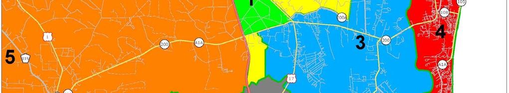
9 Figure B 1 Year 2035 Baseline Roadway Volumes (without ENCPA) Segments in RED are projected to operate over capacity. B 9 Transportation Analysis
10 Table B 4 REVISED Year 2035 Baseline Roadway Analysis (without ENCPA) VHB No. of Lanes Maximum Service Volume 2035 Baseline without ENCPA Daily Volume Capacity Exceeded? Improvement to Address Backlog Roadway From/To I 95 Duval County Line to SR 200/A1A 6D 110, ,960 YES Widen to 8 lanes SR 200/A1A to E W Interchange Rd. 6D 110,300 99,196 E W Interchange Rd. to US 17 6D 110,300 99,196 US 17 to GA State Line 6D 110,300 96,986 SR 200/A1A Griffen Rd. to I 95 4D 58,800 46,483 I 95 to Old Yulee Rd. 6D 55,300 50,197 Old Yulee Rd. to US 17 6D 55,300 48,364 US 17 to Chester Rd. 6D 55,300 58,129 YES Widen to 8 lanes Chester Rd. to Blackrock Rd. 6D 55,300 49,122 Old Nassauville Rd. to Amelia Island Parkway 4U 64,300 49,073 CR 200A/Pages Dairy Rd. US 17 to Chester Rd. 2U 16,500 10,122 CR 107N/Blackrock Rd. Chester Rd. to SR 200/A1A 2U 16,500 2,486 CR 107S/Old Nassauville Rd. SR 200/A1A to Amelia Concourse 2U 16,500 9,634 Amelia Concourse to Santa Juana Rd. 2U 16,500 3,698 Chester Rd. SR 200/A1A to Pages Dairy Rd. 4D 36,700 5,015 Pages Dairy Rd. to CR 108 Extension 4D 36,700 6,530 CR 108 Extension to Blackrock Rd. 2U 16,500 2,898 Amelia Concourse SR 200/A1A to CR 107S (Nassauville Rd.) 4D 36,700 13,097 US 17 Duval County Line to Harts Rd. 2U 22,200 25,655 YES Widen to 4 lanes Harts Rd. to Sowell Rd 2U 22,200 24,090 YES Widen to 4 lanes Sowell Rd. to SR 200/A1A 4D 36,700 12,967 SR 200/A1A to Pages Dairy Rd. 4D 36,700 9,415 Pages Dairy Rd. to Interchange Rd. 2U 21,100 9,623 Interchange Rd. to CR 108 2U 21,100 8,987 CR 108 to I 95 2U 21,100 6,899 I 95 to GA State Line 2U 21,100 6,408 I 95/SR A1A Interchange NB I 95 to SR A1A Off ramp 1L 11,100 23,188 YES Widen to 3 lanes SR A1A to NB I 95 On ramp 1L 11,100 12,112 YES Widen to 2 lanes SB I 95 to SR A1A Off ramp 1L 11,100 12,106 YES Widen to 2 lanes SR A1A to SB I 95 On ramp 1L 11,100 23,776 YES Widen to 3 lanes I 95/US 17 Interchange NB I 95 to US 17 Off ramp 1L 11,100 4,192 US 17 to NB I 95 On ramp 1L 11,100 2,420 SB I 95 to US 17 Off ramp 1L 11,100 2,420 US 17 to SB I 95 On ramp 1L 11,100 4,039 B 10 Transportation Analysis
11 B.4 ENCPA Transportation Network and Development Program The development program and transportation framework for the ENCPA were determined as part of the previous approvals for the ENCPA Sector Plan. Figure B 2 shows the proposed transportation network and development areas. A general description of the overall ENCPA development program is as follows: The area east of US 17 consists of several residential neighborhoods, each with a neighborhood center containing retail and other non residential uses. The area between US 17 and Interstate 95 contains the Employment Center and the Regional Center, which contains the majority of the regional employment and retail uses for the ENCPA. The Employment Center and Regional Center are also designed to accommodate residential units. Two separate residential neighborhoods are located north and south ends of the ENCPA. The northern neighborhood (Neighborhood A) is west of Interstate 95 along US 17. The southern neighborhood (Neighborhood H) is south of SR A1A adjacent to Interstate 95. Table B 5 summarizes the overall ENCPA development program by neighborhood and presents the total trip generation based on ITE 8 th Edition rates. As shown in the table, the entire ENCPA is estimated to have a gross trip generation of 379,721 daily trips. Of this total, approximately half (193,000 trips, or 51% of the total) are generated by the Employment Center and Regional Center areas between US 17 and Interstate 95. The remaining trips are generated by the residential neighborhoods located east of US 17 and in the separate outparcels to the north and south. Figure B 3 shows the ENCPA transportation network as entered into the model (2035 NERPM) for analysis. The major components included in the model are as follows: CR 108 Extension The east west spine of TerraPointe will be an extension of CR 108 east from US 17 to Chester Road. This roadway will provide access to neighborhood areas and also provide an alternate coastal evacuation route for eastern Nassau County. Due to the rail corridor adjacent to US 17, an overpass with interchange ramps is proposed where the CR 108 Extension crosses US 17. The CR 108 Extension is in the adopted Comprehensive Plan for Nassau County, but is not included in the adopted regional model, since it was not identified as a cost feasible improvement at the time. B 11 Transportation Analysis


12 Figure B 2 Previously Approved ENCPA Master Plan and Transportation Framework B 12 Transportation Analysis
13 Table B 5 ENCPA Daily Trip Generation (pg 1 of 2) ITE Daily Neighborhood Land Use Category Intensity Trips A SF Residential du 6,792 Apartment du 0 Retail ,000 sf 5,633 Subtotal 12,425 B SF Residential 210 1,624 du 13,511 Apartment du 1,639 Retail ,000 sf 9,404 Subtotal 24,554 C SF Residential 210 1,481 du 12,412 Apartment du 1,639 Retail ,000 sf 8,451 Subtotal 22,502 D SF Residential 210 1,936 du 15,881 Apartment du 1,639 Retail ,000 sf 9,588 Subtotal 27,108 E SF Residential 210 1,170 du 9,992 Apartment du 0 Retail ,000 sf 5,633 Subtotal 15,625 F SF Residential 210 2,433 du 19,597 Apartment du 1,639 Retail ,000 sf 8,451 Subtotal 29,687 B 13 Transportation Analysis
14 Table B 5 ENCPA Daily Trip Generation (pg 1 of 2) ITE Daily Neighborhood Land Use Category Intensity Trips G SF Residential 210 1,439 du 12,088 Apartment du 0 Retail ,000 sf 6,568 Subtotal 18,656 H SF Residential du 6,792 Apartment du 0 Retail ,000 sf 2,758 Subtotal 9,550 Resort Condominium 230 1,513 units 6,836 District Timeshare (1) 265 1,513 units 7,588 Apartment du 1,075 Retail ,000 sf 7,851 Hotel rooms 3,268 Subtotal 26,618 Employment Apartment 220 2,500 du 16,625 Center and TOD Retail ,000 sf 24,058 Office Park 750 1,890,000 sf 20,103 Industrial Park 130 4,410,000 sf 30,694 Subtotal 91,480 Regional Center SF Residential 210 5,696 du 54,511 Apartment du 0 Office ,000 sf 4,607 Office Park ,000 sf 5,515 Retail 820 1,200,000 sf 34,151 Industrial Park ,000 sf 2,732 Subtotal 101,516 TOTAL GROSS TRIP GENERATION 379,721 Source: ITE Trip Generation, 8th Edition 4/28/12 (1) Trip generation for Timeshare is based on 50% occupancy. B 14 Transportation Analysis
15 Figure B 3 ENCPA Network and TAZs Added to Model B 15 Transportation Analysis
16 North South Regional Center Arterial The north south spine of the Regional Center and Employment Center will be a road connection between SR A1A and US 17. This roadway will also parallel Interstate 95 and is intended to provide capacity relief for local trips while minimizing the amount of project traffic that uses Interstate 95. New I 95 Interchange and Connector Road Within the Employment Center and Regional Center, a new interchange with Interstate 95 is proposed between SR A1A and US 17. The interchange will provide capacity for ENCPA traffic and minimize the traffic impacts to the existing interchanges to the north and south. Access to the interchange will be through a new east west roadway that will cross US 17 (with an overpass and ramps) and connect to the CR 108 Extension. Employment Center Collector Roads As part of the development of the Employment Center north of SR A1A, collector roadways are proposed to support internal circulation between parcels. The following Mobility Network components are proposed but were not included in the model: Local Roadways (2 lanes) In addition to the arterial and collector roadways included in the Mobility Network, a supporting network of local streets will be completed to provide access to parcels within the Central Planning Area. Connectivity standards for the network of arterial, collector and local streets are defined as part of the ENCPA Sector Plan. Trail System A system of multi use trails is planned to provide non auto travel choices within the ENCPA. The trail system will accommodate pedestrians, bicyclists and golf carts. Approximately 100 miles of trails are included as part of the Mobility Network. The development program and roadway network were added to the Year 2035 model to identify long term conditions with the development of ENCPA. Each neighborhood as shown in the trip generation table (Table B 5) was assigned its own TAZ in the model. Given the geographic size of the Employment Center and Regional Center, these areas were divided into multiple TAZs, with the development program distributed evenly among them. Four TAZs were used for the Employment Center and three TAZs were used for the Regional Center. B 16 Transportation Analysis
17 B.5 ENCPA Analysis Results and Recommended Improvements Based on the addition of the overall ENCPA development program and roadway network to the Year 2035 model, the future year volumes were developed. As initial steps in developing the total roadway volumes, the following components were reviewed: Background traffic The background (non ENCPA) traffic was based on the baseline Year 2035 model run described earlier in this section. ENCPA project traffic from model In evaluating the model results, the total volumes presented include both internally captured trips and regional external trips. This is because trips remaining within the ENCPA may still use roadways such as US 17 and the CR 108 extension for travel within the community. ENCPA trip distribution The distribution of ENCPA trips was reviewed based on aggregate areas within Nassau County and the region, rather than on a segment by segment basis. Figure B 4 shows the aggregate areas used to compare the trip distribution calculations. Table B 6 shows the trip distribution produced by the model. The analysis showed that almost 71% of the trips associated with the ENCPA are expected to remain within Nassau County. This is consistent with one of the goals of the ENCPA Sector Plan to provide employment opportunities to support new and existing County residents. This trip distribution is also consistent with the project goals of maximizing internal capture through a balanced mix of uses. Total roadway volumes The future conditions traffic volumes represent the total volumes projected by the model with the addition of the ENCPA development. In some instances, background trips from the baseline nobuild scenario are expected to become project trips, as the employment base created within the ENCPA allows Nassau County residents to stay within the County for work trips. This approach of using total traffic volumes directly from the model is based on guidance from the NCHRP report Evaluating and Communicating Model Results: Guidebook for Planners. Impacts of local street connectivity As mentioned earlier, the ENCPA Sector Plan provides guidelines for local streets to ensure that they form a connected system between and within neighborhoods. This reduces the need for internal traffic to use the primary street network. However, local streets generally are not included in travel demand models. To account for this extra capacity, project traffic estimates for internal streets were reduced by 15 percent. This factor accounts for the share of trips within ENCPA that are shorter distance (less than two miles) and can occur through biking, walking, and/or local streets. The need for adjustment for these factors is also acknowledged in the NCHRP report mentioned above. Internal trails network As mentioned earlier, the ENCPA is proposed to contain approximately 50 miles of multi use trails that can accommodate pedestrians, bicyclists and golf carts. Similar to local streets, however, these trails are not included in the travel demand model. To estimate the benefit B 17 Transportation Analysis
18 of this connectivity and extra capacity, project traffic estimates for internal streets were reduced by 5 percent. Table B 7 presents the Year 2035 roadway volumes with the addition of ENCPA development. This analysis shows the following roadways are projected to operate over capacity with ENCPA development: Interstate 95 from Duval County Line to US 17 SR 200/A1A from Old Yulee Road to US 17 SR 200/A1A from Chester Road to Blackrock Road B 18 Transportation Analysis


19 Figure B 4 Aggregate Areas for Trip Distribution Evaluation B 19 Transportation Analysis
20 Table B 6 Trip Distribution Summary from Model Area (from Figure B 4) Trip Distribution 1 and 2 (ENCPA) 46.54% 3 and 4 (Eastern Nassau County) 18.45% 5 (Western Nassau County) 5.92% 6 (Duval County and points south) 27.14% 7 (Georgia and points norths) 1.95% TOTAL % Within Nassau County 70.91% Outside Nassau County 29.09% B 20 Transportation Analysis
21 Table B 7 REVISED (1 of 3) Year 2035 Roadway Analysis with ENCPA Roadway From/To 2035 Baseline without ENCPA Daily Volume Capacity Exceeded? Improvement to Address Backlog No. of Lanes Maximum Service Volume Reductions 2035 Internal Trails System Local Street Connections I 95 Duval County Line to SR 200/A1A 119,960 YES Widen to 8 lanes 8D 146,500 30, , % YES SR 200/A1A to E W Interchange Rd. 99,196 6D 110,300 39, , % YES E W Interchange Rd. to US 17 99,196 6D 110,300 11, ,676 99% US 17 to GA State Line 96,986 6D 110,300 4,481 96,986 88% SR 200/A1A Griffen Rd. to I 95 46,483 4D 58,800 5,584 52,067 89% Roadway Capacity Used Capacity Exceeded? Mobility Recommendation Additional capacity through N S Regional Center Arterial and regional commuter rail I 95 to Old Yulee Rd. 50,197 6D 55,300 8,051 58, % YES Additional capacity through Interchange Rd Old Yulee Rd. to US 17 48,364 6D 55,300 5,306 53,670 97% US 17 to Chester Rd. 58,129 YES Widen to 8 lanes 8D 73,800 5,818 63,947 87% Chester Rd. to Blackrock Rd. 49,122 6D 55,300 7,901 57, % YES Additional capacity through intersection improvements Old Nassauville Rd. to Amelia Island Parkway 49,073 4U 64,300 6,087 55,160 86% CR 200A/Pages Dairy Rd. US 17 to Chester Rd. 10,122 2U 16,500 2, ,266 74% CR 107N/Blackrock Rd. Chester Rd. to SR 200/A1A 2,486 2U 16, ,114 13% CR 107S/Old Nassauville Rd. SR 200/A1A to Amelia Concourse 9,634 2U 16, ,475 57% Amelia Concourse to Santa Juana Rd. 3,698 2U 16, ,370 20% Chester Rd. SR 200/A1A to Pages Dairy Rd. 5,015 4D 36,700 15,206 20,221 55% Pages Dairy Rd. to CR 108 Extension 6,530 4D 36,700 7,062 13,592 37% CR 108 Extension to Blackrock Rd. 2,898 2U 16,500 1,892 4,790 29% Amelia Concourse SR 200/A1A to CR 107S (Nassauville Rd.) 13,097 4D 36, ,051 38% US 17 Duval County Line to Harts Rd. 25,655 YES Widen to 4 lanes 4U 64,300 1,448 27,103 42% Harts Rd. to Sowell Rd 24,090 YES Widen to 4 lanes 4U 64,300 2,682 26,772 42% Sowell Rd. to SR 200/A1A 12,967 4D 36,700 3,151 16,118 44% SR 200/A1A to Pages Dairy Rd. 9,415 4D 36,700 6,486 15,901 43% Pages Dairy Rd. to Interchange Rd. 9,623 2U 21,100 6,991 16,614 79% Interchange Rd. to CR 108 8,987 2U 21,100 7,324 16,311 77% CR 108 to I 95 6,899 2U 21,100 11,668 18,567 88% I 95 to GA State Line 6,408 2U 21,100 4,142 10,550 50% I 95/SR A1A Interchange NB I 95 to SR A1A Off ramp 23,188 YES Widen to 3 lanes 3L 33, ,188 70% SR A1A to NB I 95 On ramp 12,112 YES Widen to 2 lanes 2L 22,200 1,029 13,141 59% SB I 95 to SR A1A Off ramp 12,106 YES Widen to 2 lanes 2L 22, ,101 59% SR A1A to SB I 95 On ramp 23,776 YES Widen to 3 lanes 3L 33, ,776 71% I 95/US 17 Interchange NB I 95 to US 17 Off ramp 4,192 1L 11,100 6,758 10,950 99% US 17 to NB I 95 On ramp 2,420 1L 11,100 1,290 3,710 33% SB I 95 to US 17 Off ramp 2,420 1L 11,100 1,269 3,689 33% US 17 to SB I 95 On ramp 4,039 1L 11,100 6,877 10,916 98% Net New ENCPA Trips Daily Roadway Volume B 21 Transportation Analysis
22 Table B 7 REVISED, cont. (2 of 3) Year 2035 Roadway Analysis with ENCPA Roadway From/To 2035 Baseline without ENCPA Daily Volume Capacity Exceeded? Improvement to Address Backlog No. of Lanes Maximum Service Volume Reductions 2035 Internal Trails System Local Street Connections Roadway Capacity Used Capacity Exceeded? Mobility Recommendation CR 108 Extension Chester Rd. to Interchange Rd. 2U 16,500 17,809 2, ,247 86% Interchange Rd. to US 17 2U 16,500 10,578 1, ,462 51% US 17 to I 95 Overpass 2U 16,500 14,106 2, ,285 68% SR A1A to Interchange Rd. 4D 36,700 12,996 1, ,397 28% N S Regional Center Arterial DSAP Collector Loop Rd. to Interchange Rd. 4D 36,700 6, ,114 14% Interchange Rd. to CR 108 4D 36,700 26,672 4,001 1,334 21,338 58% CR 108 to US 17 4D 36,700 2, ,182 6% Interchange Rd. I 95 to N S Regional Center Arterial 6D (2) 55,300 30,065 30,065 54% N S Regional Center Arterial to US 17 4D 36,700 25,203 3,780 1,260 20,162 55% US 17 to CR 108 4D 36,700 22,547 3,382 1,127 18,038 49% DSAP Collector Loop Rd. N S Regional Center Arterial to Interchange Rd. 2U 16,500 10,381 1, ,305 50% DSAP Collector (A1A Connector) SR A1A to DSAP Collector Loop Rd. 2U 16,500 14,014 2, ,211 68% VHB 11/26/2012 Net New ENCPA Trips Daily Roadway Volume B 22 Transportation Analysis
23 Table B 7 REVISED, cont. (3 of 3) Year 2035 Roadway Analysis with ENCPA North South Cordon Line Analysis (Cordon Line located north of SR A1A) 2035 Maximum Daily Roadway Service Roadway Capacity North South Roadway From/To Volume Volume Used I 95 SR 200/A1A to E W Interchange Rd. 110, , % N S Regional Center Arterial SR A1A to Interchange Rd. 36,700 10,397 28% DSAP Collector (A1A Connector) SR A1A to DSAP Collector Loop Rd. 16,500 11,211 68% US 17 Pages Dairy Rd. to Interchange Rd. 21,100 16,614 79% Chester Rd Pages Dairy Rd. to CR 108 Extension 36,700 13,592 37% Total all North South Routes 221, ,505 85% East West Cordon Line Analysis (Cordon Line located west of Chester Road) 2035 Maximum Daily Roadway Service Roadway Capacity East West Roadway From/To Volume Volume Used CR 108 Extension Chester Rd. to Interchange Rd 16,500 14,247 86% CR 200A/Pages Dairy Rd. US 17 to Chester Rd. 16,500 12,266 74% SR 200/A1A US 17 to Chester Rd. 73,800 63,947 87% Total all East West Routes 106,800 90,460 85% B 23 Transportation Analysis
24 An important component of the mobility approach is the provision of transportation capacity through network connectivity and alternate routes. Table B 7 also summarizes the recommended mobility solution to address the capacity issues identified. In most cases, the recommended approach provides for additional capacity on parallel routes. In the case of SR A1A between I 95 and Old Yulee Road, it is proposed that parallel capacity be provided through the CR 108 Extension. For the section of SR A1A between Chester Road and Blackrock Road, intersection improvements are proposed in the form of additional left turn lanes at the Chester Road and Blackrock Road intersections. In the case of Interstate 95, it is proposed that parallel capacity be provided through the north south arterial roadway through the Regional Center and Employment Center. Similarly, ENCPA impacts at the existing I 95 interchanges at SR A1A and US 17 will be addressed through the construction of a new interchange. This interchange has been assumed in the transportation analysis and the costs are included in the Mobility Network discussed below. Figure B 5 shows the recommended Mobility Network to support the buildout of the ENCPA. The numbers below correspond to the Figure. 1) CR 108 Extension 2) New I 95 Interchange 3) Interchange Road 4) US 17 widening 5) Employment Center north south road 6) Employment Center collector roads 7) Traffic signals at major intersections 8) Intersection left turn lane improvements 9) Internal trails (not shown on exhibit) These improvements will be funded and implemented over time based on the construction of development within the ENCPA and the trips generated by this development. Table B 8 summarizes the estimated ENCPA costs for the Mobility Network in Year As shown in the table, the total estimated cost is $ million. Key assumptions regarding the ENCPA costs are as follows: All costs are in Year 2012 Dollars. Transportation costs per mile are based on costs from improvements within the adopted FDOT Work Program within Nassau County and District 2. Right of way costs are estimated as $15,000 per acre, with corridor widths consistent with the illustrative cross sections in the Mobility chapter. For corridors such as CR 108 where excess capacity is provided, the ENCPA share of the cost is calculated as the capacity used (plus overages on parallel corridors) divided by the total roadway capacity. In the case of CR 108, the ENCPA volumes at buildout plus the capacity overage from SR A1A equate to 77% of the total roadway capacity. B 24 Transportation Analysis
 Recommended")

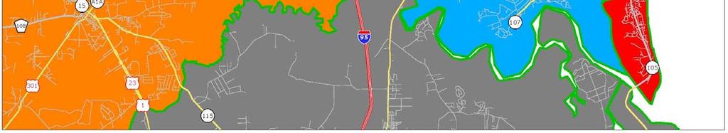
25 Figure B 5 (REVISED 4/12/13) Recommended ENCPA Mobility Network B 25 Transportation Analysis
26 Table B 8 REVISED Mobility Improvements Summary Design and Construction Cost per Mile Design and Roadway/Segment Length TerraPointe Multi Use Construction ROW TOTAL TERRAPOINTE (miles) Improvement Share Roadway Path (12') Sidewalk Subtotal Subtotal COST SHARE CR 108 Extension US 17 to Interchange Rd 1.7 New 2 lane road 77% $3,027,000 $163,321 $102,285 $5,597,430 $498,000 $6,095,430 $4,693,481 Interchange Rd to Resort Area 3.7 New 2 lane road 77% $3,027,000 $163,321 $102,285 $12,182,642 $1,083,000 $13,265,642 $10,214,544 Resort Area to Chester Rd 1.6 New 2 lane road 77% $3,027,000 $163,321 $102,285 $5,268,170 $468,000 $5,736,170 $4,416,851 Interchange Road Interstate 95 to N S Regional Center Arterial 1.1 New 4 lane road 100% $4,644,000 $163,321 $102,285 $5,400,567 $322,000 $5,722,567 $5,722,567 East Frontage Rd to US New 4 lane road 100% $4,644,000 $163,321 $102,285 $5,891,527 $351,000 $6,242,527 $6,242,527 US 17 to CR New 4 lane road 100% $4,644,000 $163,321 $102,285 $10,310,173 $615,000 $10,925,173 $10,925,173 Interchange Road at I 95 New interchange 100% $23,650,000 $75,000 $23,725,000 $23,725,000 Employment Center Collector Roads 2.3 New 2 lane road 100% $3,027,000 $163,321 $102,285 $7,572,994 $489,000 $8,061,994 $8,061,994 N S Regional Center Arterial US 17 to CR New 4 lane road 100% $4,644,000 $163,321 $102,285 $5,891,527 $351,000 $6,242,527 $6,242,527 CR 108 to Interchange Road 3.6 New 4 lane road 100% $4,644,000 $163,321 $102,285 $17,674,582 $1,054,000 $18,728,582 $18,728,582 Interchange Road to SR 200/A1A 1.9 New 4 lane road 100% $4,644,000 $163,321 $102,285 $9,328,251 $556,000 $9,884,251 $9,884,251 US 17 N S Regional Center Arterial to I Widen to 4 lanes 50% $5,676,000 $163,321 $102,285 $7,129,927 $87, $7,216,927 $3,608,464 Traffic Signals (at 10 new major intersections) Install new signal 100% $3,500,000 $3,500,000 SR A1A Intersection Improvements Dual left turn lanes at SR A1A/Chester Rd New left turn lane 100% $250,000 $250,000 Dual left turn lanes at SR A1A/Blackrock Rd New left turn lane 100% $250,000 $250,000 Internal multi use trail system % $163,321 $8,166,050 $8,166,050 $8,166,050 (off street) TOTAL $124,063,840 $ 5,949,000 $134,012,840 $124,632,011 VHB B 26 Transportation Analysis
27 B.6 Recommended Improvements Employment Center DSAP This section summarizes the Mobility Network improvements associated with the buildout of the DSAP. As stated earlier, these improvements were identified based on the components needed to support development of this portion of the ENCPA. The improvements are discussed for each of the three Planning Areas (Central, Northern and Southern) associated with the DSAP. B.6.1 Central Planning Area Figure B 6 summarizes the mobility improvements associated with the Central Planning Area. These improvements were identified based on the development program of 2,500 multi family residential units and 7,000,000 square feet of nonresidential uses (retail, office and industrial). This program for the Central Planning Area generates an estimated 91,480 daily trips at buildout. Table B 9 summarizes the development program and its trip generation. Within the Central Planning Area, the following transportation improvements have been identified: North South Arterial Roadway (4 lanes) This roadway will extend through the Central Planning Area (the Employment Center) and continue north through the Regional Center and connect to US 17. This roadway will serve as the spine of the ENCPA for areas between US 17 and Interstate 95. A traffic signal is assumed at the intersection of this roadway and SR A1A. East West Interchange Road (4 lanes) This roadway will provide access to the Central Planning Area from US 17. An interchange with Interstate 95 is assumed at the buildout of the Central Planning Area. As areas of the ENCPA east of US 17 are developed, the Interchange Road will be extended to the east. Collector Roadways (2 lanes with turn lanes) The collector roadways for the Central Planning Area provide a second access point to and from SR A1A, as well as connections to the TOD area near US 17. Local Roadways (2 lanes) In addition to the arterial and collector roadways included in the Mobility Network, a supporting network of local streets will be completed to provide access to parcels within the Central Planning Area. Connectivity standards for the network of arterial, collector and local streets are defined as part of the ENCPA Sector Plan. B 27 Transportation Analysis
28 Table B 9 DSAP Trip Generation North Area Neighborhood A ITE Daily Land Use Category Intensity Trips SF Residential du 6,792 Apartment du 0 Retail ,000 sf 5,633 Gross Total North Area 12,425 Central Area Employment Center ITE Daily Land Use Category Intensity Trips Apartment 220 2,500 du 16,625 Retail ,000 sf 24,058 Office Park 750 1,890,000 sf 20,103 Industrial Park 130 4,410,000 sf 30,694 Gross Total Central Area 91,480 South Area Neighborhood H ITE Daily Land Use Category Intensity Trips SF Residential du 6,792 Apartment du 0 Retail ,000 sf 2,758 Gross Total South Area 9,550 Source: ITE Trip Generation, 8th Edition 4/28/12 B 28 Transportation Analysis
29 Figure B 6 DSAP Mobility Network B 29 Transportation Analysis
30 Trail System A system of multi use trails is planned to provide non auto travel choices within the Central Planning Area. The trail system will accommodate pedestrians, bicyclists and golf carts. Approximately 10 miles of trails are included as part of the Mobility Network for this area. Transit Oriented Development The Central Planning Area provides opportunities for TOD around any future stations developed as part of a commuter rail system between Nassau County and downtown Jacksonville. Such a system has been included in the adopted MPO Long Range Transportation Plan, as discussed earlier in this section. For short term (five year) conditions, the total development program for the Central Planning Area consists of 350 multi family residential units and 400,000 square feet of office. This development is expected to occur along the north south arterial road near SR A1A. Based on ITE trip generation calculations, this development program generates a total of 6,822 daily trips. Table B 10 summarizes this calculation. For short term conditions, all access will be via SR A1A. As discussed earlier, SR A1A through the Central Planning Area is funded for widening to six lanes as part of FDOT s adopted Five Year Work Program. This improvement provides the additional capacity necessary to accommodate short term development. It is recommended that the following new signals be implemented to address the five year impacts of the DSAP; the total cost for these improvements is $700,000. Traffic signal at SR A1A and North/South Arterial Traffic signal at SR A1A and DSAP Collector Road In terms of internal Mobility Network needs, the short term improvements are limited to roadway segments needed to provide access to development parcels. This may include the initial segments of the North South Arterial, constructed as two lanes. Table B 10 Five Year DSAP Development Program Daily Trip Generation ITE Daily Land Use Category Intensity Trips Apartment du 2,245 Office Park ,000 sf 4,577 Total 6,822 B 30 Transportation Analysis
31 B.6.2 Northern Planning Area The transportation network to support the Northern Planning Area consists of local streets and internal trails. No regional roadways are proposed. The total development program for the Northern Planning Area consists of 769 single family residential units and 75,000 square feet of retail; this program produces an estimated 12,425 daily trips. Access to the Northern Planning Area is limited to a single roadway, US 17, with two access points recommended. Environmental constraints to the north and Interstate 95 to the east restrict the opportunity for additional connectivity. For short term (five year) conditions, no development is projected within the Northern Planning Area. Therefore, no short term transportation improvements have been identified for this area. However, given the current capacity availability on US 17 as documented in the existing conditions analysis earlier in this section, it is reasonable to expect that a small increment of development could be accommodated within the next five years without triggering any adverse roadway impacts. B.6.3 Southern Planning Area The transportation network to support the Southern Planning Area consists of local streets and internal trails. No regional roadways are proposed. The total development program for the Southern Planning Area consists of 769 single family residential units and 25,000 square feet of retail; this program produces an estimated 9,550 daily trips. Existing access to the Southern Planning Area is limited to a single roadway, William Burgess Boulevard, to the northeast. Additional connections to the north to SR A1A have been identified as possible, but are not required to support development of this area. Environmental constraints to the south and Interstate 95 to the west restrict the opportunity for additional connectivity. For short term (five year) conditions, no development is projected within the Southern Planning Area. Therefore, no short term transportation improvements have been identified for this area. However, given the current capacity availability on William Burgess Boulevard as documented in the existing conditions analysis earlier in this section, it is reasonable to expect that a small increment of development could be accommodated within the next five years without triggering any adverse roadway impacts. B 31 Transportation Analysis
APPENDIX G: INTERSECTION NEEDS AT OKEECHOBEE BOULEVARD
 APPENDIX G: INTERSECTION NEEDS AT OKEECHOBEE BOULEVARD INTERSECTION NEEDS AT SR 7 and OKEECHOBEE BOULEVARD SR 7 Extension Project Development and Environment (PD&E) Study From Okeechobee Boulevard (SR
4. ENVIRONMENTAL IMPACT ANALYSIS 9. TRANSPORTATION AND TRAFFIC
 4. ENVIRONMENTAL IMPACT ANALYSIS 9. TRANSPORTATION AND TRAFFIC 4.9.1 INTRODUCTION The following section addresses the Proposed Project s impact on transportation and traffic based on the Traffic Study
Chapter 5 Future Transportation
 Chapter 5 Future Transportation The Future Land Use Plan identifies the desired land use designations. The land uses desired for Crozet depend, in large part, on the success of the transportation system,
List of Exhibits...ii
 One Brickell Traffic Study TABLE OF CONTENTS List of Exhibits...ii EXECUTIVE SUMMARY...1 1. INTRODUCTION...2 1.1 Study Area...2 1.2 Study Objective...5 2. EXISTING TRAFFIC CONDITIONS...6 2.1 Data Collection...6
MOUNTAIN HOUSE SPECIFIC PLAN I 9.1 INTRODUCTION ASSUMPTIONS TRANSPORTATION FACILITIES TRANSPORTATION IMPROVEMENTS PHASING 9.
 CHAPTER NINE: TRANSPORTATION AND CIRCULATION 9.1 INTRODUCTION 9.1 9.2 ASSUMPTIONS 9.1 9.3 TRANSPORTATION FACILITIES 9.1 9.4 TRANSPORTATION IMPROVEMENTS PHASING 9.3 LIST OF FIGURES LIST OF TABLES Figure
City of Wayzata Comprehensive Plan 2030 Transportation Chapter: Appendix A
 A1. Functional Classification Table A-1 illustrates the Metropolitan Council s detailed criteria established for the functional classification of roadways within the Twin Cities Metropolitan Area. Table
Clackamas County Comprehensive Plan
 ROADWAYS The County s road system permits the movement of goods and people between communities and regions, using any of a variety of modes of travel. Roads provide access to virtually all property. They
CITY OF COCOA BEACH 2025 COMPREHENSIVE PLAN. Section VIII Mobility Element Goals, Objectives, and Policies
 CITY OF COCOA BEACH 2025 COMPREHENSIVE PLAN Section VIII Mobility Element Goals, Objectives, and Policies Adopted August 6, 2015 by Ordinance No. 1591 VIII MOBILITY ELEMENT Table of Contents Page Number
3.0 Future Conditions
 3.0 Future Conditions In order to be able to recommend appropriate improvements to the transportation system of the Town, it is important to first understand the nature and volume of traffic that is expected
Appendix C. NORTH METRO STATION AREA TRAFFIC IMPACT STATEMENT 88th Avenue Station
 Appendix C NORTH METRO STATION AREA TRAFFIC IMPACT STATEMENT 88th Avenue Station Prepared for: Regional Transportation Department and URS Corporation as part of the North Metro EIS David Evans and Associates,
CITY OF ALPHARETTA DOWNTOWN MASTER PLAN TRAFFIC EVALUATION
 CITY OF ALPHARETTA DOWNTOWN MASTER PLAN TRAFFIC EVALUATION June 2015 CITY OF ALPHARETTA DOWNTOWN MASTER PLAN TRAFFIC EVALUATION Introduction The Alpharetta Downtown Master Plan was developed in the fall
Waterford Lakes Small Area Study
 Waterford Lakes Small Area Study Existing Traffic Conditions PREPARED FOR: ORANGE COUNTY PUBLIC WORKS DEPARTMENT TRAFFIC ENGINEERING DIVISION ORLANDO, FLORIDA PREPARED WITH: INWOOD CONSULTING ENGINEERS
Corpus Christi Metropolitan Transportation Plan Fiscal Year Introduction:
 Introduction: The Safe, Accountable, Flexible, Efficient Transportation Equity Act: A Legacy for Users (SAFETEA-LU) has continued the efforts started through the Intermodal Surface Transportation Efficiency
GOAL 2A: ESTABLISH AND MAINTAIN A SAFE, CONVENIENT, AND EFFICIENT MULTI-MODAL TRANSPORTATION SYSTEM TO MOVE PEOPLE AND GOODS THROUGHOUT THE CITY.
 2. TRANSPORTATION ELEMENT The purpose of this element is to assist in establishing an adequate transportation system within the City and to plan for future motorized and non-motorized traffic circulation
Circulation in Elk Grove includes: Motor vehicles, including cars and trucks
 Circulation, as it is used in this General Plan, refers to the many ways people and goods move from place to place in Elk Grove and the region. Circulation in Elk Grove includes: Motor vehicles, including
5.0 Roadway System Plan
 Southwest Boise Transportation Study Page 16 5.0 Roadway System Plan The Roadway System Plan outlines roadway improvements in the Initial Study Area. It forecasts future deficiencies on the arterial system,
Route 7 Corridor Study
 Route 7 Corridor Study Executive Summary Study Area The following report analyzes a segment of the Virginia State Route 7 corridor. The corridor study area, spanning over 5 miles in length, is a multi
Most Important Part of any Plan
 Most Important Part of any Plan Objectives must be evaluated to determine if they have been achieved Achievement of Objectives: 10 of 13 Objectives Achieved 1 not achieved 2 not due yet Transportation
Chapter 4 Traffic Analysis
 Chapter 4 Traffic Analysis PURPOSE The traffic analysis component of the K-68 Corridor Management Plan incorporates information on the existing transportation network, such as traffic volumes and intersection
Magnolia Place. Traffic Impact Analysis. Prepared for: City of San Mateo. Prepared by: Hexagon Transportation Consultants, Inc.
 Magnolia Place Traffic Impact Analysis Prepared for: City of San Mateo Prepared by: Hexagon Transportation Consultants, Inc. Updated January 4, 2010 Table of Contents 1. Introduction...1 2. Existing Conditions...6
Basalt Creek Transportation Refinement Plan Recommendations
 Basalt Creek Transportation Refinement Plan Recommendations Introduction The Basalt Creek transportation planning effort analyzed future transportation conditions and evaluated alternative strategies for
STREET AND HIGHWAY PLAN
 STREET AND HIGHWAY PLAN Introduction The street and highway system in the Winston-Salem Urban Area consists of thousands of miles of traffic carrying facilities, ranging from short local residential streets
Solana Beach Comprehensive Active Transportation Strategy (CATS)
") Solana Beach Comprehensive Active Transportation Strategy (CATS) 3.0 Goals & Policies The Solana Beach CATS goals and objectives outlined below were largely drawn from the Solana Beach Circulation Element
Solana Beach Comprehensive Active Transportation Strategy (CATS) 3.0 Goals & Policies The Solana Beach CATS goals and objectives outlined below were largely drawn from the Solana Beach Circulation Element
Goodlettsville Bicycle and Pedestrian Plan Executive Summary
 Goodlettsville Bicycle and Pedestrian Plan July 2010 In Cooperation with the Nashville Area Metropolitan Planning Executive Organization Summary Introduction Progressive and forward thinking communities
City of Gainesville Transportation/Roadway Needs PROJECT SUMMARY
 A1 Roadway Resurfacing $23,846,000 TYPE: Preservation of existing system Roadway resurfacing A2 Signal Replacement $6,000,000 TYPE: Preservation of existing system Replace traffic signals. B1 W 6th St
TRAFFIC IMPACT STUDY CRITERIA
 Chapter 6 - TRAFFIC IMPACT STUDY CRITERIA 6.1 GENERAL PROVISIONS 6.1.1. Purpose: The purpose of this document is to outline a standard format for preparing a traffic impact study in the City of Steamboat
2.0 Ballpark District
 2.0 Ballpark District 2.1 Introduction The Ballpark District is located in the south central portion of the City of Lake Elsinore, just north of the City limit line in this area. The Ballpark District
Chapter 6 Transportation Plan
 Chapter 6 Transportation Plan Transportation Plan Introduction Chapter 6 Transportation Plan Transportation Plan Introduction This chapter describes the components of Arvada s transportation system, comprised
Traffic Impact Statement
 Traffic Impact Statement Mixed Use Development, US 41 and Old Trail Drive aka Tide-Starbucks 4900 9 th Street North General Development Site Plan (GDSP) Collier County, FL 10/6/2015 Prepared for: Prepared
SECTION 1 - TRAFFIC PLANNING
 SECTION 1 - TRAFFIC PLANNING 1.1 TRAFFIC OPERATIONS 1.1.1 Roadway Functional Classification The Multnomah County Comprehensive Framework Plan s Policy 34: Trafficways and the Functional Classification
City of Bartow Comprehensive Plan. Transportation Element
 City of Bartow 2030 Comprehensive Plan Amended through January 7, 2013 TRANSPORTATION ELEMENT GOAL: IT SHALL BE A GOAL OF THE CITY OF BARTOW TO PROVIDE A SAFE AND EFFICIENT MULTI-MODAL TRANSPORTATION SYSTEM
2. TRANSPORTATION ELEMENT.
 2. TRANSPORTATION ELEMENT. The purpose of this element is to assist in establishing an adequate transportation system within the City and to plan for future motorized and non-motorized traffic circulation
Project Description Form 8EE
 Project Description Form 8EE Basic Project Information Submitting Jurisdiction/Agency: Town of Dumfries Project Title: Route 1 (Fraley Blvd) Widening: Brady's Hill Road to Dumfries Road Project Location:
Exhibit 1 PLANNING COMMISSION AGENDA ITEM
 Exhibit 1 PLANNING COMMISSION AGENDA ITEM Project Name: Grand Junction Circulation Plan Grand Junction Complete Streets Policy Applicant: City of Grand Junction Representative: David Thornton Address:
APPENDIX D: Southwest Volusia Regional Transportation Study. Evaluation Criteria FINAL
 D: PROJECT PRIORITIZATION Prioritization of the improvements proposed in the Multimodal Improvement Plan is required in order to determine which projects should be funded first, where the transportation
TRAFFIC STUDY GUIDELINES Clarksville Street Department
 TRAFFIC STUDY GUIDELINES Clarksville Street Department 9/1/2009 Introduction Traffic studies are used to help the city determine potential impacts to the operation of the surrounding roadway network. Two
3.9 Recreational Trails and Natural Areas
 3.9 Recreational Trails and Natural Areas 3.9.1 Introduction Parks and other recreational facilities such as trails, bicycle routes, and open space are important community resources. This section discusses
CHAPTER 4: IDENTIFICATION OF ROAD SYSTEM DEFICIENCIES: TRANSPORTATION PLANNING MODEL
 CHAPTER 4: IDENTIFICATION OF ROAD SYSTEM DEFICIENCIES: TRANSPORTATION PLANNING MODEL I. INTRODUCTION Transportation planning models are the primary tools used to predict future travel conditions. With
INTRODUCTION THOROUGHFARE SYSTEM CLASSIFICATIONS
 INTRODUCTION The thoroughfare plan will assist public officials in the development of a specialized system for efficient and safe movement of vehicular traffic while minimizing potential conflicts with
RESOLUTION NO ?? A RESOLUTION OF THE CITY OF NEPTUNE BEACH ADOPTING A COMPLETE STREETS POLICY
 RESOLUTION NO. 2018-?? A RESOLUTION OF THE CITY OF NEPTUNE BEACH ADOPTING A COMPLETE STREETS POLICY WHEREAS, safe, convenient, and accessible transportation for all users is a priority of the City of Neptune
10A. DATE: October 5, Pedestrian and Bicycle Advisory Committee. Kevin Colin, Deputy Planning Manager Curt Bates, City Engineer
 10A DATE: October 5, 2016 TO: PREPARED BY: SUBJECT: Pedestrian and Bicycle Advisory Committee Kevin Colin, Deputy Planning Manager Curt Bates, City Engineer Discussion and Provide Comments, Associated
REGIONAL PRIORITIES Presentation to the Tampa Bay Regional Collaboration Committee September 10, 2012
 WEST CENTRAL FLORIDA MPO CHAIRS COORDINATING COMMITTEE REGIONAL PRIORITIES Presentation to the Tampa Bay Regional Collaboration Committee September 10, 2012 TRANSPORTATION REGIONAL INCENTIVE PROGRAM (TRIP)
SOLANA BEACH BICYCLE TRANSPORTATION PLAN SECOND ADDENDUM
 SOLANA BEACH BICYCLE TRANSPORTATION PLAN SECOND ADDENDUM Prepared by the City of Solana Beach January 2005 Introduction In June of 1993, the Solana Beach City Council adopted a Bikeway Master Plan as directed
Highway 111 Corridor Study
 Highway 111 Corridor Study June, 2009 LINCOLN CO. HWY 111 CORRIDOR STUDY Draft Study Tea, South Dakota Prepared for City of Tea Sioux Falls Metropolitan Planning Organization Prepared by HDR Engineering,
Transportation Master Plan Advisory Task Force
 Transportation Master Plan Advisory Task Force Network Alternatives & Phasing Strategy February 2016 BACKGROUND Table of Contents BACKGROUND Purpose & Introduction 2 Linking the TMP to Key Council Approved
Phone: Fax: Project Reference No. (to be filled out by MassHighway):
:") Massachusetts Highway Department District 3 Project Need Form (PNF) This form is intended to provide preliminary information about the proposed project. It is not expected that all information that is
Massachusetts Highway Department District 3 Project Need Form (PNF) This form is intended to provide preliminary information about the proposed project. It is not expected that all information that is
Prepared For: Shieldbay Developments Inc. c/o Matson, McConnell Ltd. 2430A Bloor Street West Toronto, Ontario M6S 1P9.
 Prepared For: Shieldbay Developments Inc. c/o Matson, McConnell Ltd. 2430A Bloor Street West Toronto, Ontario M6S 1P9 Prepared By: URS Canada Inc. 4 th Floor, 30 Leek Crescent Richmond Hill, Ontario L4B
Sixth Line Development - Transit Facilities Plan
 Memorandum Date: November 13, 2012 To: From: c.c. Subject: Rob Freeman (Freeman Planning) Kevin Phillips Sixth Line Development - Transit Facilities Plan 33016631 This memo was prepared to review the transit
City of Homewood Transportation Plan
 City of Homewood Transportation Plan Prepared for: City of Homewood, Alabama Prepared by: Skipper Consulting, Inc. May 2007 TABLE OF CONTENTS INTRODUCTION... 1 BACKGROUND INFORMATION... 1 EXISTING TRANSPORTATION
INNER LOOP EAST. AIA Rochester Annual Meeting November 13, 2013 TRANSFORMATION PROJECT. Bret Garwood, NBD Erik Frisch, DES
 INNER LOOP EAST TRANSFORMATION PROJECT AIA Rochester Annual Meeting November 13, 2013 Bret Garwood, NBD Erik Frisch, DES Why? We are building a city that encourages walking, biking and enjoying the outdoor
5 CIRCULATION AND STREET DESIGN
 5 CIRCULATION AND STREET DESIGN This chapter describes circulation and streetscape improvements proposed for the Northwest Chico Specific Plan Area. It includes detailed design specifications for existing
Highway 49, Highway 351 and Highway 91 Improvements Feasibility Study Craighead County
 Highway 49, Highway 351 and Highway 91 Improvements Feasibility Study Craighead County Executive Summary March 2015 Highway 49, Highway 351 and Highway 91 Improvements Feasibility Study Craighead County
Classification Criteria
 SCHEDULE D TO RECOMMENDED OFFICIAL PLAN AMENDMENT NO. 40 SCHEDULE C-4 Road Criteria Criteria Traffic Service Objective Land Service/Access Typical Daily Traffic Volume Flow characteristics Travel Speed
Roadway Classification Design Standards and Policies. Pueblo, Colorado November, 2004
 Roadway Classification Design Standards and Policies Pueblo, Colorado November, 2004 Table of Contents Page Chapter 1. General Provisions 1.1 Jurisdiction 3 1.2 Purpose and Intent 3 1.3 Modification 3
State Road 54/56 Tampa Bay s Northern Loop. The Managed Lane Solution Linking I-75 to the Suncoast Parkway
 State Road 54/56 Tampa Bay s Northern Loop The Managed Lane Solution Linking I-75 to the Suncoast Parkway SUNCOAST PARKWAY Both I 75 and the Suncoast Parkway are planning, or in the process of constructing,
Madison Urban Area and Dane County. Bicycle Transportation Plan Summary. September Introduction. Bicycle Plan Scope and Planning Process
 Bicycle Transportation Plan Summary Madison Urban Area and Dane County Introduction September 2000 Bicycling is an important mode of transportation in the Madison urban area and countywide that is available
3.0 PROJECT DESCRIPTION
 The following section of the Draft EIR contains a description of the proposed Elk Grove Boulevard/SR 99 Interchange Modification project, consistent with the requirements of CEQA Guidelines Section 15124.
5858 N COLLEGE, LLC N College Avenue Traffic Impact Study
 5858 N COLLEGE, LLC nue Traffic Impact Study August 22, 2016 Contents Traffic Impact Study Page Preparer Qualifications... 1 Introduction... 2 Existing Roadway Conditions... 5 Existing Traffic Conditions...
Executive Summary Route 30 Corridor Master Plan
 Route Corridor Master Plan Project Overview The Route Corridor Master Plan is a coordinated multimodal transportation and land use plan for the entire stretch of Route through East Whiteland Township,
Glenn Avenue Corridor Traffic Operational Evaluation
 Glenn Avenue Corridor Traffic Operational Evaluation PREPARED FOR: THE CITY OF AUBURN PREPARED BY: DECEMBER 2007 Glenn Avenue Corridor Study--Auburn, Alabama TABLE OF CONTENTS Introduction... 1 Background
Bridge Street Corridor Study Report
 Bridge Street Corridor Study Report Prepared for: Prepared by: BRIDGE STREET CORRIDOR STUDY REPORT PREPARED FOR: CITY OF ARROYO GRANDE COMMUNITY DEVELOPMENT DEPARTMENT 300 EAST BRANCH STREET ARROYO GRANDE,
COMPLETE STREETS A STEP FORWARD ITE District 10/FSITE Annual Meeting November 3, 2015
 COMPLETE STREETS A STEP FORWARD 2015 ITE District 10/FSITE Annual Meeting November 3, 2015 About Lakeland Incorporated: 1885 Population: 100,728 Area: Approx. 75 sq. mi Major Employers: Publix, Lakeland
ADA Transition Plan. City of Gainesville FY19-FY28. Date: November 5, Prepared by: City Of Gainesville Department of Mobility
 ADA Transition Plan FY19-FY28 Date: November 5, 2018 Prepared by: City Of Gainesville Department of Mobility 1.0 INTRODUCTION 1.1 BACKGROUND The federal statute known as the Americans with Disabilities
TRAFFIC ASSESSMENT River Edge Colorado
 TRAFFIC ASSESSMENT River Edge Colorado Submitted by: Fehr & Peers 621 17th Street, Ste. 231 Denver, CO 8293 (33) 296-43 December, 21 App. M-2 Traffic Assessment River Edge Colorado December 21 TABLE OF
Marina Loft (DRC 51-R-12)
") Marina Loft (DRC 51-R-12) traffic study prepared for: Cymbal Development OCtober 2012 Traf Tech October 1, 2012 Mr. Asi Cymbal - President Cymbal Development 3470 North Miami Avenue Upper Suite Miami,
Marina Loft (DRC 51-R-12) traffic study prepared for: Cymbal Development OCtober 2012 Traf Tech October 1, 2012 Mr. Asi Cymbal - President Cymbal Development 3470 North Miami Avenue Upper Suite Miami,
JONESBORO HIGHWAY 63 HIGHWAY 18 CONNECTOR STUDY
 JONESBORO HIGHWAY 63 HIGHWAY 18 CONNECTOR STUDY Craighead County May 2007 JONESBORO HIGHWAY 63 HIGHWAY 18 CONNECTOR STUDY Craighead County May 2007 Prepared by Planning and Research Division Arkansas State
4.0 TRAFFIC IMPACT STUDIES
 SECTION 4 4.0 TRAFFIC IMPACT STUDIES 4.1 TRAFFIC IMPACT STUDY REQUIREMENTS The City has established Traffic Impact Study (TIS) requirements for the purpose of ensuring that both the quantitative and qualitative
APPENDIX L: COST ESTIMATING TOOLS
 APPENDIX L: COST ESTIMATING TOOLS Rural Arterial From LRE MOT * Mobilization * Subtotal Scope Contingency (25%) Total PE Design (15%) CEI (15%) Total Project ** New (2-Lane Roadway) with 5' Paved Shoulders
SANTA CLARA COUNTYWIDE BICYCLE PLAN August 2008
 SANTA CLARA COUNTYWIDE BICYCLE PLAN August 2008 To assist VTA and Member Agencies in the planning, development and programming of bicycle improvements in Santa Clara County. Vision Statement To establish,
IOTA CAROL COMPREHENSIVE PLAN AMENDMENT TRAFFIC ANALYSIS
 IOTA CAROL COMPREHENSIVE PLAN AMENDMENT TRAFFIC ANALYSIS December 28, 215 Revised January 29, 216 Revised February 23, 216 COMPREHENSIVE PLAN AMENDMENT TRAFFIC ANALYSIS Iota Carol PALM BEACH COUNTY, FL
FINAL DESIGN TRAFFIC TECHNICAL MEMORANDUM
 FINAL DESIGN TRAFFIC TECHNICAL MEMORANDUM July 2014 FINAL (SR 43) Project Development and Environment Study From State Road 60 (Adamo Drive) to I-4 (SR 400) Hillsborough County, Florida Work Program Item
TABLE OF CONTENTS. Executive Summary
 Executive Summary Background... ES-1 Pedestrian Network... ES-2 Bikeway Network... ES-2 Collision History... ES-2 Public Input... ES-4 Conclusions and Recommendations... ES-4 1. Introduction and Setting
SUMMARY Public Kick-Off Meeting on June 11, 2031 State Road (SR) 514 (Malabar Road) Project Development and Environment (PD&E) Study
 514 (Malabar Road) Project Development and Environment (PD&E) Study") www.sr514malabar.com SUMMARY Public Kick-Off Meeting on June 11, 2031 State Road (SR) 514 (Malabar Road) Project Development and Environment (PD&E) Study LOCATION: Palm Bay Hospital Auditorium 1425 Malabar
www.sr514malabar.com SUMMARY Public Kick-Off Meeting on June 11, 2031 State Road (SR) 514 (Malabar Road) Project Development and Environment (PD&E) Study LOCATION: Palm Bay Hospital Auditorium 1425 Malabar
Project Description Form 6V
 Project Description Form 6V Basic Project Information Submitting Jurisdiction/Agency: Prince William County Project Title: Route 15 Widening: Route 55 to south of RR tracks & Construct RR Overpass Project
This document may be reprinted or extracted without permission, provided credit to the City of Pasadena Department of Transportation
 TRANSPORTATION IMPACT ANALYSIS CURRENT PRACTICE & GUIDELINES Prepared by: Transportation Complete Streets Division Department of Transportation 20150925 This document may be reprinted or extracted without
RZC Appendix 8A Marymoor Subarea Street Requirements
 RZC Appendix 8A Marymoor Subarea Street Requirements For additional design details for Marymoor Subarea infrastructure, refer to the 2017 Marymoor Subarea Infrastructure Planning Report. STREET REQUIREMENTS
FRONT RANGE CROSSINGS TRAFFIC IMPACT STUDY
 FRONT RANGE CROSSINGS TRAFFIC IMPACT STUDY Prepared for: City of Thornton And Colorado Department of Transportation Prepared by: 11 Blake Street, Suite 2 Denver, Colorado 822 Contact: Brian Bern, PE, PTOE
Chapter 2: Standards for Access, Non-Motorized, and Transit
 Standards for Access, Non-Motorized, and Transit Chapter 2: Standards for Access, Non-Motorized, and Transit The Washtenaw County Access Management Plan was developed based on the analysis of existing
CLARKSBURG PREMIUM OUTLETS AT CABIN BRANCH LOCAL AREA TRANSPORTATION REVIEW EXEMPTION STATEMENT
 CLARKSBURG PREMIUM OUTLETS AT CABIN BRANCH LOCAL AREA TRANSPORTATION REVIEW EXEMPTION STATEMENT May 12, 2014 CLARKSBURG PREMIUM OUTLETS AT CABIN BRANCH TRANSPORTATION REVIEW EXEMPTION STATEMENT MONTGOMERY
ADOT Statewide Bicycle and Pedestrian Program Summary of Phase IV Activities APPENDIX B PEDESTRIAN DEMAND INDEX
 ADOT Statewide Bicycle and Pedestrian Program Summary of Activities APPENDIX B PEDESTRIAN DEMAND INDEX May 24, 2009 Pedestrian Demand Index for State Highway Facilities Revised: May 29, 2007 Introduction
SR-203 Sidewalks and Town-Wide Mobility Improvements. Town Council Presentation September 7, 2016
 SR-203 Sidewalks and Town-Wide Mobility Improvements Town Council Presentation September 7, 2016 SR-203 Sidewalks and Town- Wide Mobility Improvements SR-203 Sidewalks and Appurtenances Town-Wide Mobility
Downtown Naples Mobility and Connectivity Study. Naples City Council Presentation January 2017
 Downtown Naples Mobility and Connectivity Study Naples City Council Presentation January 2017 Agenda 1. Introduction 2. Scope Review 3. Project Schedule 4. Existing Conditions 5. Public Charrette 6. Mobility
Transportation Impact Study for Abington Terrace
 Transportation Impact Study for Abington Terrace Abington Township, Montgomery County, PA Sandy A. Koza, P.E., PTOE PA PE License Number PE059911 Prepared by McMahon Associates, Inc. 425 Commerce Drive,
TRAFFIC IMPACT STUDY COMPREHENSIVE UPDATE TOWN OF THOMPSON S STATION, TENNESSEE PREPARED FOR: THE TOWN OF THOMPSON S STATION
 TRAFFIC IMPACT STUDY COMPREHENSIVE UPDATE TOWN OF THOMPSON S STATION, TENNESSEE PREPARED FOR: THE TOWN OF THOMPSON S STATION Transportation Consultants, LLC 1101 17 TH AVENUE SOUTH NASHVILLE, TN 37212
2025 Comprehensive Plan for the City of Temple Terrace Florida. Mobility Element. Adopted by City Council June 30, 2009
 2025 Comprehensive Plan for the City of Temple Terrace Florida Mobility Element Adopted by City Council June 30, 2009 Effective Date September 22, 2009 GOAL 2: To protect and promote the quality of life
Arterial Management Plan for US Route 250 and State Route 623
 Arterial Management Plan for US Route 250 and State Route 623 June 25, 2014 Brad Shelton, AICP Access Management and Traffic Impact Analysis Programs Manager Transportation and Mobility Planning Division
Lee s Summit Road Improvement Study Public Open House June 7, 2007 Summary of Comment Card Responses
 Lee s Summit Road Improvement Study Public Open House June 7, 2007 Summary of Comment Card Responses Introduction At the Lee s Summit Road Improvement Study Public Open House held Thursday, June 7, 2007
LANE ELIMINATION PROJECTS
 PRESENTATION OUTLINE Lane Elimination Considerations Districts 4 & 7 Draft Lane Elimination Processes FDOT Lane Elimination Guidelines Example Projects D4 Case Study: SR A1A (Ft. Lauderdale) D7 Case Study:
Lyons Avenue/Dockweiler Road Extension Project Draft Environmental Impact Report. Appendix I Traffic Impact Study
 Lyons Avenue/Dockweiler Road Extension Project Draft Environmental Impact Report Appendix I Traffic Impact Study Street 0 80-1947 500.4501 RITA ld Court 0 91355-1096 400.7401 LA n Avenue 0 590-3745 300-9301
FORM A PASCO COUNTY ACCESS CONNECTION PERMIT APPLICATION
 FORM 901.3.A PASCO COUNTY ACCESS CONNECTION PERMIT APPLICATION The following information is required from all applicants directly or indirectly accessing any collector or arterial road or as otherwise
King Soopers #116 Thornton, Colorado
 Traffic Impact Study King Soopers #116 Thornton, Colorado Prepared for: Galloway & Company, Inc. 1.0 EXECUTIVE SUMMARY King Soopers #116, a grocery marketplace anchored commercial development, is proposed
D.13 Transportation and Traffic
 This section addresses transportation and traffic issues and impacts related to the Proposed Project. Section D.13.1 provides a description of the affected environment for the Proposed Project. Applicable
9 Leeming Drive Redevelopment Ottawa, ON Transportation Brief. Prepared By: Stantec Consulting Ltd.
 9 Leeming Drive Redevelopment Ottawa, ON Transportation Brief Prepared By: Stantec Consulting Ltd. TIA GUIDELINES CHECKLIST Report Context Municipal Address Comment: Section 1.1 Location relative to major
Access Management Regulations and Standards
 Access Management Regulations and Standards January 2014 Efficient highway operation Reasonable property access Concept of Access Management The way to manage access to land development while preserving
Shockoe Bottom Preliminary Traffic and Parking Analysis
 Shockoe Bottom Preliminary Traffic and Parking Analysis Richmond, Virginia August 14, 2013 Prepared For City of Richmond Department of Public Works Prepared By 1001 Boulders Pkwy Suite 300, Richmond, VA
Financial Project ID No(s).: and ETDM No(s).: and 14181
.: and ETDM No(s).: and 14181") Palm Beach Metropolitan Planning Organization (MPO) Presentation I-95 at Boynton Beach Boulevard Interchange and I-95 at Gateway Boulevard Interchange Project Development and Environment Study Palm Beach
Palm Beach Metropolitan Planning Organization (MPO) Presentation I-95 at Boynton Beach Boulevard Interchange and I-95 at Gateway Boulevard Interchange Project Development and Environment Study Palm Beach
Traffic Impact Memorandum. May 22, 2018
 BISHOP PROFESSIONAL DEVELOPMENT BUILDING Proposed Land-use Change & Parking Modification 3601 SW 31st Street Topeka, Kansas 66614 CFS Project No. 185077 Traffic Impact Memorandum May 22, 2018 Prepared
7 NE 145TH STREET STATION TOD POTENTIAL
 7 NE 145TH STREET STATION TOD POTENTIAL Key Findings The 145th Street Station area has limited TOD potential, primarily because of its location in an area that is currently zoned predominantly single-family
Access Management Regulations and Standards
 Access Management Regulations and Standards Efficient highway operation Reasonable property access Concept of Access Management The way to manage access to land development while simultaneously preserving
SANTA MONICA BOULEVARD CORRIDOR
 CIRCULATION ELEMENT WHITE PAPER NO. 3 SANTA MONICA BOULEVARD CORRIDOR INTRODUCTION From the 1930s to the beginning of Los Angeles freeway era, Santa Monica Boulevard, (previously Route 66, the Beverly