MnDOT District 6 Community Outreach. Rice County - Summer 2017
|
|
|
- Susanna Paulina Stone
- 5 years ago
- Views:
Transcription

1 MnDOT District 6 Community Outreach Rice County - Summer 2017

2 Introduction MnDOT Planning Office works with local government partners, stakeholders, corporations and members of the public to produce plans and to help identify future projects Here to introduce plans 2

3 Today s Agenda 10-year district work plan Overview Process Next steps Discussion 3

4 District 10 Year Work Plan Statewide Transportation Improvement Program, STIP = next 4 years Capital Highway Investment Plan, CHIP = Years 5 10 Both are updated annually 4
5 Funding 5

6 Funding Optional Tagline Goes Here mndot.gov/ 6
7 How are Projects Selected? Engineers and planners look at range of needs Mix of different fixes for each type of need Preservation focus moving forward Percent of Roadway Miles 20% 18% 16% 14% 12% 10% 8% 6% 4% 2% 0% 3.8% "Poor" Ride Quality Index, Non-Interstate NHS System (RQI <= 2.0) 10.4% Actual 2016 Predicted 2021 ( STIP) Predicted 2027 ( CHIP) 7.9% 0.8% 4.1% 8.8% 0.7% 3.0% 1.5% 0.8% 6.4% 5.2% 1.9% 4.8% 4.4% 5.5% ATP-1 ATP-2 ATP-3 ATP-4 ATP-6 ATP-7 ATP-8 Metro 7Statewide 8.8% 10.9% 1.7% 8.0% 9.6% 1.6% 5.0% 4.8% 2.0% 5.9% 6.8%

8 Optional Tagline Goes Here mndot.gov/ 8

9 Optional Tagline Goes Here mndot.gov/ 9
10 Current Year Projects MN19, Bridge Replacement Bridge Number 8844 near CR52 Estimate: $390,000 MN60, Bituminous Mill and Overlay from Bridge 5370 over Straight River in Faribault to Huseth Ave in Kenyon Estimate: $6,578,000 10

11 Upcoming Programmed Projects - Map 11
12 Upcoming Programmed Projects Next Four Years: I35, Bituminous mill and overlay on southbound lanes from North of MN21 to North of CSAH 9 including ramps Year: 2018 Estimate: $1.5 Million I35, Clarks Grove Weigh Station and Inspection Site Improvement Project Year: 2018 Estimate: $0.25 Million MN60, Bituminous mill and overlay in the City of Faribault urban section from the junction of MN21 to Central Avenue including ADA improvements Year: 2019 Estimate: $6.6 Million MN21, Bituminous mill and overlay from 1.7 Miles North of I35 to MN99 Year: 2021 Estimate: $3.5 Million Maintenance signing replacements, striping, patching 12

13 Upcoming Programmed Projects - Map 13
14 Planned Projects Planned Years 5-10 Out: I35, Concrete unbonded overlay, from CSAH48 to MN21 Year: 2023 Estimate: $12.7M MN19, Bituminous mill and overlay, 21 miles overall from MN13 to MN3 Year: 2023 Estimate: $10.1M MN246, Bituminous mill and overlay from MN3 to Nerstrand Year: 2024 Estimate: $5.9M I35, Concrete pavement rehab from north of MN21 to Rice/Scott Line Year: 2027 Estimate: $6.2M MN60, Bituminous mill and overlay from 0.3 MI East of MN13 to MN21 Year: 2028 Estimate: $8.9M *Planned projects may be moved up, back or dropped altogether based on constraints 14
15 10 Year Work Plan Next Steps What s Next: 1. Follow-up on our pre-scoping meeting with communities 2. Meet with our project managers to discuss updates 3. Scoping draft projects 4. Start to select new projects for next update 15

16 Coordination Are there upcoming projects or infrastructure work that MnDOT should be coordinating with you on? 16
17 Discussion What are some current issues or concerns that you have? 17
18 Questions, Updates and More Ronda Allis Transportation Planning Director MnDOT District 6 ronda.allis@state.mn.us
19 Year 2017 MnDOT District 6 Construction Projects Le Sueur Waterville Waseca Waseca Scott New Richland?A 13 «2 Rice Lonsdale Morristown Elko New Market?A 21 Owatonna «3 Ellendale?A 298?A 3 Dundas Medford Northfield?A 246 Faribault «19 Steele 218 Dakota «11 Blooming Prairie?A 19?A 58 Wanamingo Kenyon «11?A 57 «13?A 60 Mazeppa «5 Claremont?A 30 Cannon Falls «9 Dodge «10 52 Goodhue West Concord?A 56 Dodge Center Hayfield Kasson «8 Mantorville Goodhue Zumbrota Pine Island Rochester Oronoco «8 «15?A Olmsted Byron Stewartville Red Wing 63 «16 Fillmore 52 Lake City Wabasha?A 247?A 42 Elgin Eyota 61 Plainview Chatfield?A 74 Wabasha 61 Saint Charles?A 250?A 248 Goodview Rollingstone Lewiston Stockton Winona Rushford Village Rushford Listing Winona «6?A 76 Miles «14 Description Hwy 16 repaving west of Hwy 26 to Hwy 61 and Hwy 61 to near junction 1 of Hwys 16 and 61 2 Hwy 19 bridge replacement - Bridge No I-35 bridge replacements south of Owatonna, (six bridges) plus four 3 bridges on Hwy 14 south of Owatonna (first year) 4 I-35 cable median barrier from Iowa border to I-90 Albert Lea 5 Hwy 42 bridge replacement near Kellogg and Hwy 61 6 Hwy 43 Winona bridge rehabilitation of existing Bridge No Hwy 44 repaving through Hokah, plus ADA improvements Hwy 52 repaving northbound lanes from north of Rochester to south of 8 Cannon Falls, includes high-tension cable median barrier from Oronoco to north of Zumbrota 9 Hwy 52 bridge replacements over Little Cannon River at Cannon Falls Hwy 52 interchange repair, improvements at Goodhue County Road at Cannon Falls Hwy 56 bridge replacements near Kenyon over North Fork of Zumbro 11 River - Bridge No and Prairie Creek - Bridge No Hwy 56 repaving from Taopi to I-90, reconstruction in Adams with ADA 12 improvements Hwy 58 bridge replacement at Hwy 52 in Zumbrota, roundabouts at 13 ramp, ADA improvements Hwy 61 southbound bridge replacement of Bridge No over Trout 14 Creek 15 Hwy 63 bridge replacement at Red Wing over Mississippi River Hwy 63 extension of traffic management system from 40th Street S in 16 Rochester to I-90 I-90 bridge replacement in Austin under 11th Drive NE - Bridge No Hwy 139 repaving and ADA improvements from Iowa state line to Hwy in Harmony Hwy 60 repaving and ADA improvements from east end of Faribault to 19 the west end of Kenyon «1 4 La Crescent Alden Freeborn Albert Lea Clarks Grove 35?A 251 Glenville ?A 105 «17 Lyle Brownsdale Austin Adams «4 «12 Grand Meadow Mower Le Roy Spring Valley?A 80 Preston «18?A 16 Lanesboro Harmony?A 139?A 44?A 43 Mabel Spring Grove Houston Caledonia Houston Hokah «7?A 26 Brownsville Source D6 PPMS Projects 2016
20 MNDOT DISTRICT 6 LONG RANGE CONSTRUCTION PLANS SP NEW MN19 Year: 2023 HWY 19 REPAVING FROM HWY 13 TO HWY 3 IN RICE COUNTY Waterville Freeborn SP NEW I90 Year: 2024 I-90 REPAVING FROM ALDEN TO HWAY 13 Alden?A 109 Date: 6/13/2017 Waseca New Richland Conger?A 13 Hartland Morristown Manchester Emmons 90 Twin Lakes Lonsdale 69?A Elko New Market SP NEW I35 Year: 2023 I-35 REPAVING ALL LANES FROM RICE COUNTY ROAD 48 TO HWY 21 Ellendale SP NEW I35 Year: 2025 I-35 REHABILITATE CONCRETE PAVEMENT ON ALL LANES FROM IOWA BORDER TO HWY 30 SP NEW MN13 Year: 2025 HWY 13 REPAVING FROM I-90 TO HWY 30 Albert Lea Clarks Grove?A 251 Glenville SP NEW I35 Year: 2027 I-35 REHABILITATE CONCRETE PAVEMENT ON ALL LANES FROM HWY 21 TO RICE/SCOTT COUNTY LINE?A 3 Faribault?A 299 Geneva 65?A 298 Medford Dundas Owatonna Hayward Hollandale Northfield SP NEW I35 Year: 2026 I-35 REPAVING FROM NORTH OF HWY 30 TO NORTH OF BRIDGE IN STEELE COUNTY?A 246 Nerstrand 218 Dennison Blooming SP NEW US218 Year: 2023 Prairie HWY 218 RECONSTRUCT FROM 0.6 MI S S JCT TH 30 TO S JCT TH 30 (BLOOMING PRAIRIE) SP NEW MN251 Year: 2023 HWY 251 REPAVING FROM I-35 TO HWY 218 SP YR2023 I 90 AUSTIN DESIGN BUILD, REPLACE 4 BRIDGES AND REHABILITATE 3 BRIDGES SP I90 Year: 2022 I-90 REPAVING EASTBOUND LANES FROM FREEBORN COUNTY ROAD 46 NEAR PETRAN TO HWY 105 NEAR AUSTIN Myrtle 218?A 105 Cannon Falls SP NEW MN246 Year: 2024 HWY 246 REPAVING FROM HWY 3 TO NERSTRAND Kenyon Claremont SP US218 Year: 2023 HWY 218 REPAVING FROM HWY 30 NEAR BLOOMING PRAIRIE TO HWY 14 NEAR OWATONNA SP NEW MN30 Year: 2026 HWY 30 REPAVING FROM HWY 218 IN BLOOMING PRAIRIE TO HWY 56 IN HAYFIELD?A 30 Austin Mapleview Lyle 52?A 56?A 19 SP NEW MN60 Year: 2026 HWY 60 REPAVING FROM HUSETH AVE IN KENYON TO HWY 52 IN GOODHUE COUNTY West Concord SP NEW US218 Year: 2027 HWY 218 REPAVING FROM WEST OF I-90 JUNCTION TO SOUTH OF HWY 30 JUNCTION IN MOWER COUNTY?A 57 Wanamingo Kasson?A 58 Goodhue Zumbrota?A 60 Byron Mazeppa 14 SP NEW US14 Year: 2022 Dodge HWY 14 REPAVING ALL LANES FROM OLMSTED COUNTY Center 14 Brownsdale SP NEW I90 Year: 2026 I-90 REPAVING ALL LANES FROM HWY 105 TO MOWER COUNTY ROAD 46 Hayfield Sargeant SP NEW MN56 Year: 2024 HWY 56 REPLACE BOX Rose CULVERT 6468 OVER STREAM WITH Creek BRIDGE Mantorville SP NEW MN56 Year: 2026 HWY 56 REPAVING FROM COUNTY ROAD 46 TO CITY LIMITS OF BROWNSDALE IN MOWER COUNTY SP NEW US218 Year: 2025 HWY 218 REPAVING FROM IOWA BORDER TO EAST OF I-90 JUNCTION IN MOWER COUNTY Adams Dexter Red Wing SP NEW US52 Year: 2025 HWY 52 REPLACE SOUTHBOUND BRIDGE 9414 OVER NORTH FORK OF ZUMBRO RIVER SP NEW MN57 Year: 2026 HWY 57 REPAVING FROM DODGE COUNTY ROAD 34 IN KASSON TO DODGE COUNTY ROAD 30 NEAR WANAMINGO SP NEW I90 Year: 2024 I-90 BRIDGE DECK REPLACEMENTS NEAR HWY 56, COUNTY ROAD 20, COUNTY ROAD 13, COUNTY ROAD 1, COUNTY ROAD 15 IN MOWER COUNTY, PLUS Elkton COUNTY ROAD 6 AND COUNTY ROAD 35 IN OLMSTED COUNTY Pine Island SP NEW US52 Year: 2027 HWY 52 REHABILITATION CONCRETE PAVEMENT ON ALL LANES FROM HWY 63 TO JUST SOUTH OF 85TH STREET IN OLMSTED COUNTY ROAD 36/MARION ROAD TO OLMSTED COUNTY ROAD 19 SP NEW I90 Year: 2023 I-90 REPAVING FROM EAST OF MOWER COUNTY ROAD 1 TO EAST OF HWY 63 Taopi Grand Meadow SP NEW MN16 Year: 2022 HWY 16, REPLACE BOXES 6045, 6046 AND 6047 OVER STREAMS?A 292 Bellechester SP MN60 Year: 2022 HWY 60 REPAVING AND ADA IMPROVEMENTS FROM HWY 52 TO HWY 63 NEAR ZUMBRO FALLS Oronoco 63 Stewartville Le Roy Racine SP NEW US61 Year: 2023 HWY 61 REPAVING FROM ONE MILE NORTH OF LAKE CITY TO READY MIX ENTRANCE IN RED WING SP US61 Year: 2025 HWY 61 REPLACE BRIDGE 6483 OVER HAY CREEK AND WITHERS HARBOR DRIVE AND PLUG BRIDGE 6482 OVER ABANDONED RAILROAD IN RED WING SP NEW MN60 Year: 2022 HWY 60, REPLACE BOXES 8676, 8841 AND 8890 OVER STREAMS Zumbro Falls 63 Ostrander Hammond Rochester Spring Valley Lake City Millville?A 247 SP NEW US14 Year: 2024 HWY 14 REPAVING FROM US 52 TO CSAH 36 SP NEW US52 Year: 2024 HWY 52 REPLACE BOX CULVERTS OVER STREAMS SP NEW MN247 Year: 2024 HWY 247 REPLACE BOX CULVERT 6934 OVER STREAM 52?A 42 SP NEW MN30 Year: 2024 HWY 30 REPAVING FROM HWY 63 NEAR STEWARTVILLE TO HWY 52 NEAR CHATFIELD IN OLMSTED COUNTY SP NEW MN56 Year: 2023 HWY 56 REPLACE BRIDGE 8489 OVER STREAM Wykoff Elgin SP NEW MN16 Year: 2024 HWY 16 RECONSTRUCTION FROM TRACEY ROAD (SPRING VALLEY) TO E GRISWALD ST Plainview SP NEW MN42 Year: 2023 HWY 42 REPLACE BOX CULVERTS 8669 AND 8675 OVER STREAMS SP NEW US14 Year: 2026 HWY 14 REPLACE BOX Eyota CULVERTS 4989, 4988, 8053, 8052, 8051 Dover AND 8050 OVER STREAMS Chatfield?A 80 SP NEW MN80 Year: 2024 HWY 80 REPAVING FROM HWY 16 TO HWY 52 Fountain Wabasha?A 74 Saint Charles Preston 61 Kellogg Elba SP NEW MN250 Year: 2022 HWY 250 REPAVING FROM HWY 16 TO HWY 30 IN FILLMORE COUNTY Harmony?A 139?A 248 Altura Utica SP NEW US14 Year: 2027 HWY 14 REPLACE BOX CULVERTS 6028, 6029, 6030, 6031 AND 6032 OVER STREAMS SP NEW US52 Year: 2025 HWY 52 REPAVING FROM HWY 80 TO \FILLMORE COUNTY ROAD 5?A 250 Lanesboro?A 16 SP US61 Year: 2022 HWY 61 REPAVING SOUTHBOUND LANES FROM HWY 248 IN WINONA COUNTY TO HWY 60 IN WABASHA COUNTY Whalan Canton Minneiska SP NEW MN74 Year: 2025 HWY 74 REPLACE BRIDGE OVER WHITEWATER RIVER AND REHABILITATE BRIDGE CULVERTS IN STATE PARK SP NEW MN74 Year: 2027 HWY 74 REPAVING FROM HWY 52 TO EAST OF HWY 14 JUNCTION Lewiston Rollingstone Peterson Goodview Stockton SP NEW I90 Year: 2027 I-90 REPAVING WB LANES FROM HWY 74 TO HWY 43 Rushford Village Minnesota City SP NEW MN30 Year: 2022 HWY 30 REPAVING FROM HWY 74 TO HWY 43 JUNCTION NEAR RUSHFORD IN FILLMORE COUNTY SP NEW MN43 Year: 2023 HWY 43 REPAVING FROM HWY 44 NEAR MABEL TO HWY 16 JUNCTION NEAR RUSHFORD IN FILLMORE COUNTY SP NEW US14 Year: 2027 HWY 14 REPAVING FROM W JCT HWY 74 TO HWY 61 Rushford SPNEW YR2025 HWY 16 & 76, SCOUR REMEDIATION ON BRIDGES (RUSHFORD) AND BRIDGE 6679 (YUCATAN)?A 43 Mabel?A 44 SP NEW US61 Year: 2027 HWY 61 REPAVING NB LANES FROM HWY 14 TO HWY 42 AND SB LANES FROM HWY 14 TO HWY 248 Winona SP NEW MN43 Year: 2024 HWY 43 REPLACE BOX CULVERTS AND OVER STREAMS?A 76 SP NEW MN44 Year: 2027 HWY 44 REPAVING FROM SPRING GROVE TO CALEDONIA Spring Grove SP NEW MN43 Year: 2022 HWY 43 RECONSTRUCT ALL LANES FROM HWY 61 IN WINONA TO MANKATO AVE/SARNIA AVE JUNCTION SP NEW I90 Year: 2026 I-90 REPAVING WB LANES FROM HWY 43 TO HWY 76 Houston SP NEW I90 Year: 2025 I-90 REPAVING ALL LANES FROM WINONA COUNTY ROAD 12 TO HWY 61 NEAR DAKOTA Caledonia MNDOT CONSTRUCTION YEAR Eitzen Flex Projects Ella Projects Miles SP US61 Year: 2024 HWY 61 REPLACE NORTHBOUND BRIDGE 9062 AND SOUTHBOUND BRIDGE 9063 OVER CEDAR CREEK Dakota Hokah 61 SP NEW MN44 Year: 2025 HWY 44 REPAVING FROM HOUSTON COUNTY ROAD 12 TO HOKAH La Crescent Created for using District 6 CHIP data by RAB at MnDOT. This is subject to change without notice. ¹?A 26 Brownsville
21 MNDOT DISTRICT 6 STIP 4 YEAR CONSTRUCTION PLANS Waterville Freeborn?A 109 Alden Conger Waseca New Richland?A 13 Hartland Manchester Emmons Date: 6/13/2017 Morristown Lonsdale 35 Elko New Market Ellendale 65?A 3 Medford Dundas?A 21 Nerstrand SP I35 Year: 2018 SP I-35 REPAVING SOUTHBOUND MN21 Year: 2021 LANES FROM HWY 21 HWY 21 REPAVING TO RICE COUNTY ROAD 9 FROM 1.7 MI N SP OF I 35 TO HWY 99?A 299 MN60 Year: 2019 HWY 60 RECONSTRUCTION, ADA IN RICE COUNTY IMPROVEMENTS IN FARIBAULT FROM HWY 21 TO CENTRAL AVE SP I35 Year: 2018 I-35 TRAFFIC MANAGEMENT SYSTEM IMPROVEMENTS NEAR HWY 30 SP I35 Year: 2018 I-35 CLARKS GROVE WEIGH STATION AND INSPECTION SITE IMPROVEMENT Twin Lakes Albert Lea Faribault Geneva Glenville Owatonna SP MN30 Year: 2019 HWY 30 REPAVING FROM WEST OF ELLENDALE TO 1 MILE EAST OF STEELE COUNTY ROAD 45, PLUS ADA IMPROVEMENTS. Clarks Grove?A 251 Hollandale SP I90 Year: 2018 I-90 REPAVING WESTBOUND LANES FROM HWY 13 TO FREEBORN COUNTY ROAD 46 AT PETRAN Hayward SP US65 Year: 2021 REPAVING FROM NEWTON AVE TO I-35 RAMPS IN ALBERT LEA PLUS ADA IMPROVEMENTS AND STORM SEWER REPAIR Northfield?A 246 SP US14 Year: 2019 INSTALLATION OF TRAFFIC MANAGEMENT SYSTEM EQUIPMENT ON HWY 14 FROM I-35 TO STEELE COUNTY ROAD 80. Myrtle Dennison Blooming Prairie Kenyon Claremont?A 30 SP I90 Year: 2021 I-90 REPLACE BRIDGE 9504 AT 28TH ST. SP US218 Year: 2021 HWY 218 REHAB BRIDGE AND OVER I-90 SP MN105 Year: 2021 HWY 105 REPAVING FROM IA STATE LINE TO 11 MI N IN MOWER COUNTY 218 Mapleview Austin?A 105 SP MN19 Year: 2018 BRIDGE REHABILITATION - BRIDGE NO OVER PRAIRIE CREEK Cannon Falls 52?A 56?A 19 SP NEW MN56 Year: 2021 HWY 56 REPLACE BOX 8648 OVER STREAM Lyle SP MN57 Year: 2020 ROUNDABOUT AT HWY 57 AND HWY 60 INTERSECTION - WANAMINGO?A 57 SP MN57 Year: 2019 HWY 57 BRIDGE REPLACEMENT - BRIDGE NO OVER THE NORTH BRANCH OF THE MIDDLE FORK OF THE ZUMBRO RIVER NORTH OF MANTORVILLE Waltham Brownsdale SP US52 Year: 2018 SOUTHBOUND LANES REPAVING FROM 1.2 MILES NORTH OF GOODHUE COUNTY ROAD 7 TO 2.2 MILES SOUTH OF HWY 19 Dodge Center Hayfield Rose Creek Sargeant Wanamingo Mantorville Kasson Adams Dexter Elkton Goodhue?A 58 Zumbrota Pine Island Byron SP I90 Year: 2021 I-90 REHAB BOX CULVERTS 8963, 8964 AND 8965 OVER ROSE CREEK Red Wing Taopi Mazeppa?A 292 SP US61 Year: 2018 HWY 61 ACCESS MANAGEMENT AND INTERSECTION SAFETY IMPROVEMENTS NEAR SPRING CREEK AVE. AND CAROL LANE IN RED WING Bellechester SP US63 Year: 2018 HWY 63 REPAVING FROM ZUMBRO FALLS (HWY 60) TO WABASHA COUNTY RD 78 (NORTH OF OAK CENTER)?A 60 SP US52 Year: 2019 HWY 52 INSTALLATION OF TRAFFIC MANAGEMENT SYSTEM FROM ELK RUN TO HWY 60 WEST IN ZUMBROTA Grand Meadow Oronoco SP I90 Year: 2020 I-90 REHABILITATE BRIDGES AND OVER HWY 52. SP US63 Year: 2019 HWY 63 CABLE MEDIAN BARRIER INSTALLATION FROM STEWARTVILLE TO HWY 52 SP US63 Year: 2020 HWY 63 REPLACE NB BRIDGE 9890 AND SB BRIDGE 9889 OVER I Rochester Stewartville Le Roy Racine SP MN56 Year: 2020 HWY 56 REPAVING FROM LEROY TO TAOPI Zumbro Falls Ostrander Hammond Spring Valley 52 Lake City Millville SP US63 Year: 2018 CONCRETE OVERLAY ON BLACKTOP FROM OLMSTED COUNTY ROAD 33 TO HWY 60 AND REPLACEMENT OF BRIDGE NOS AND 8313 OVER STREAM, ADA IMPROVEMENTS SP US14 Year: 2020 HWY 14 REPLACE BRIDGE 6034 OVER STREAM SP US52 Year: 2018 REPAVING HWY 52 SOUTH OF I-90 TO HWY 63 SP US61 Year: 2020 HWY 61 PAVEMENT RECONSTRUCTION IN LAKE CITY FROM WEST ELM STREET TO CENTRAL POINT ROAD 14?A 247 Elgin?A 42 Wykoff Eyota SP US52 Year: 2019 HWY 52 REPAVING, ADA IMPROVEMENTS AND BRIDGE REPLACEMENTS - BRIDGE NOS. 614, 8182 AND 8183 FROM FILLMORE COUNTY RD 5 IN CHATFIELD TO I-90 SP MN16 Year: 2020 HWY 16 REPAVING AND ADA IMPROVEMENTS FROM I-90 TO TRACY ROAD IN SPRING VALLEY 61 SP MN60 Year: 2019 REPAVING HWY 60 FROM HWY 63 AT ZUMBRO FALLS TO HWY 61 NEAR WABASHA SP MN42 Year: 2020 REPAVING FROM MN 247 TO HWY 61 Plainview SP MN42 Year: 2018 CONSTRUCT ROUNDABOUT AT OLMSTED COUNTY ROAD 9 NORTH OF EYOTA SP MN74 Year: 2020 HWY 74 REPLACE BRIDGE 5932 OVER S FORK WHITEWATER RIVER - ST CHARLES Fountain?A250 80?A Chatfield Dover Preston Wabasha SP MN74 Year: 2019 HWY 74 REPLACE BRIDGE NO SP MN74 Year: 2019 HWY 74 REHABILITATE BRIDGE NOS AND REPLACE BRIDGE NOS. 5835, 5836, 8592, 8594 SP US61 Year: 2019 HWY 61 REPAVING AND ADA IMPROVEMENTS FROM HWY 42 TO 1 MILE NORTH OF LAKE CITY. EXCLUDING LAKE CITY FOR FUTURE PROJECT?A 74 Elba Saint Charles Kellogg 61?A 16 Harmony?A 139 Altura Utica SP MN30 Year: 2021 HWY 30 REPLACE BRIDGE 9008 AND REDECK BRIDGE 9009 OVER N BRANCH ROOT RIVER Lanesboro Whalan Canton SP MN74 Year: 2019 HWY 74 REPLACE BRIDGE NO Minneiska?A 248 Lewiston SP US52 Year: 2018 REPAVING HWY 52 FROM FILLMORE COUNTY ROAD 22 TO EAST JUNCTION OF HWY 16. Rollingstone Rushford Village Peterson Stockton Minnesota City?A 43 Goodview SP YR2019 I-90 BRIDGE REPAIRS ON BRIDGE NO , , & Rushford Mabel?A 44 Winona SP YR2019 I-90 BRIDGE REPAIRS ON BRIDGE NO , , & 85803?A 76 SP NEW MN76 Year: 2021 HWY 76 REHABILITATE BRIDGE NOS. 9104, 9105 AND 9106 OVER MONEY CREEK Spring Grove SP US61 Year: 2018 REPLACE TRAFFIC SIGNAL AND ADD ADA FACILITIES AT HWY 61 AND HUFF ST. IN WINONA Houston SP I90 Year: 2019 REPAVING WESTBOUND I-90 FROM NEAR HWY 61/DAKOTA TO WEST OF WESTBOUND ENTRANCE RAMP FROM HWY 61 NORTHBOUND AND EASTBOUND I-90 FROM NEAR HWY 61/DAKOTA TO WEST OF SOUTH LIMITS OF DAKOTA. Caledonia Eitzen MNDOT CONSTRUCTION YEAR Flex Projects Ella Projects Miles SP US61 Year: 2019 HWY 61 REPAVING FROM NORTH OF I-90 TO WINONA COUNTY ROAD 15 AT HOMER Dakota Hokah 61 La Crescent Created for using District 6 CHIP data by RAB at MnDOT. This is subject to change without notice. ¹?A 26 Brownsville

22 District 6 10-Year Capital Highway Investment Plan ( ) Cover Picture DRAFT JUNE 2017 Prepared by Office of Transportation System Management
.")
23 DISTRICT 6 10-YEAR CHIP OVERVIEW District 6 s 10-Year Capital Highway Investment Plan (CHIP) communicates the next 10-years of planned projects in the district. The planned projects align with the goals and objectives set in the Minnesota 20-Year State Highway Investment Plan (MnSHIP). This CHIP, along with those of the seven other districts in the state, will meet the investment targets outlined in the 2017 MnSHIP for the next ten years. The project information is current as of May 2017 and does not include new revenue provided by the legislature in the 2017 session. MnDOT is currently going through a process to select projects with the additional revenue. These projects will be included in next year s CHIP document published in The 10-Year CHIP includes: An overview of the district, including a map of highway network type. (6-3) A summary of planned investments over the next 10 years. (6-4) Investment strategies for the major investment categories, detailing how each MnDOT district plans to most efficiently deliver projects. (6-5) A description of program highlights, changes from the last CHIP, and remaining risks at the district level assuming the 10 years of projects are implemented. (6-6) Historic and projected performance in the district, to give context to the impact of the planned investment program. (6-7) A list of projects for the next ten years, broken into investment categories, and mapped by year. With a few exceptions, such as district wide projects, set-asides, and landscaping projects, all of the projects in the district are listed here. Projects listed in years 5-10 are not formal commitments of the agency and are likely to change in scope, projected cost, or projected year. This CHIP is updated annually and reflects MnDOT s plans at a snapshot in time. By comparing these plans year-to-year, changes in the planned program are apparent. Updating this on an annual basis allows a greater degree of transparency with stakeholders, and aligns with MnDOT s annual Major Highway Projects Report. The 2017 MnSHIP guides the overall direction of the 10-Year capital Highway CHIP until the next MnSHIP is completed. To obtain more information or become more involved, contact District 6 Transportation Planning Director, Ronda Allis, at Ronda.allis@ state.mn.us or PAGE YEAR CAPITAL HIGHWAY INVESTMENT PLAN

24 District 6 Overview District 6 shares the southeast portion of Minnesota with District 7. It has three regional offices located in Rochester, Owatonna, and Winona, which are also regional trade centers. District 6 offices are staffed by 376 full-time employees. Major industries in the district include health care and social assistance, manufacturing, and retail trade. There are 21 truck stations located in District 6, three of which are at regional offices. The district has 439 bridges that are ten feet or greater in length and 433 miles of rail. Counties* Dodge, Fillmore, Freeborn, Goodhue, Houston, Mower, Olmsted, Rice, Steele, Wabasha and Winona Centerline Miles 1,410 Lane Miles 3,662 High Mast Lights 46 Bridge Culverts 402 Noise Walls 13 Overhead Signs 150 Population ,335 Annual VMT** 3,570,787,581 VMT/Capita 7,193 *Based on ATP boundaries **VMT=Vehicle Miles Traveled on Trunk Highways Figure 6-1: State Highways witin District 6 "a$?±a@? A@ )p?òa@?èa@ "`$ )s?õa@?ºa@?±a@?õa@ )s?ùa@ )p?¹a@? A@? A@?±A@ Northfield?ºA@? A@ )p?ùa@?¹a@?ºa@?±a@ Faribault?ÜA@?ÜA@ "`$?±A@?ÚA@?ÙA@ )o "`$ Owatonna )o?±a@ ){?ÃA@?ÃA@?ÃA@?±A@?½A@?ÙA@ ){ "a$ Albert Lea )u )v?þa@ ){ "`$ )s? A@?ÛA@?ÜA@ )o "a$?³a@ )p Red Wing Lake City )s )t?ía@?ºa@?ía@?ça@ Rochester )o?ãa@ )p Stewartville )t?ìa@?³a@ )p )t?sa@?¼a@ )p "a$?»a@?³a@ Interstate (206 miles) National Highway System - Non-Interstate (338 miles) Non-National Highway System - (865 miles) Metro 7 6 )s?îa@?îa@?èa@?îa@ Winona La Crescent?³A@?èA@?ÏA@?ÏA@? A@ DRAFT DISTRICT 6 10-YEAR CAPITAL HIGHWAY INVESTMENT PLAN ( ) PAGE 6-3
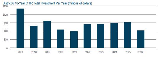
25 District 6 CHIP Investment Over the next ten years, District 6 is projected to invest roughly $822 million in state highway projects (Figure 6-2). The majority of projects will address pavement and bridge condition. While the primary purpose of these projects will be to address pavement and bridge conditions, MnDOT also will address other needs along the project such as the condition of roadside infrastructure such as signage, culverts, and lighting, implement new safety improvements, address pedestrian infrastructure that does not comply with the Americans with Disabilities Act, and make limited investments in bicycle infrastructure. District 6 investment peaks in 2019 at roughly $100 million. Investment after 2019 fluctuates annually between roughly $60 and $100 million. HIGHWAY INVESTMENT STRATEGIES Over the next ten years, District 6 will incorporate different strategies for their state highway investments. The strategies have been grouped into the five major investment objective areas. System Stewardship Continue to assess pavement condition and evaluate options to respond to those highways that display the highest needs that is cost Figure 6-2: District 6 10-Year CHIP Investment by Investment Category (millions of dollars) Total Investment = $822M SP $2M RC $6M AP $18M BI $5.8M PD $106M TS $49M PC $417M RI $68M BC $148M Note: No investment for Facilities, Jurisdictional Transfer, Freight, or Greater MN Mobility System Stewardship PC BC RI JT FA Pavement Condition Bridge Condition Roadside Infrastructure Jurisdictional Transfer Facilities Critical Connections TC GM FR BI AP Twin Cities Mobility Greater Minnesota Mobility Freight Bicycle Infrastructure Accessible Pedestrian Infrastructure TS RC PD SP Traveler Safety Regional + Community Improvement Priorities Project Delivery Small Programs PAGE YEAR CAPITAL HIGHWAY INVESTMENT PLAN
26 Figure 6-3: District 6 10-Year CHIP, Total Investment Per Year (millions of dollars) $100 $80 $60 $40 $20 $ effective and will optimize pavement life Continue to coordinate roadside infrastructure investments (culverts, guardrail, signing) with other preservation projects Pursue turnbacks of Non-NHS roadways by working closely with local jurisdictions and optimizing funding sources Transportation Safety Implement strategies identified in the District Highway Safety Plan that would be eligible for funding from the HSIP program Maintain the flexibility react to changing conditions within the statewide safety emphasis areas Coordinate safety investment, as appropriate, with other preservation projects to minimize disruption to travelers Critical Connections Continue District Municipal Agreements program to strategically improve the bicycle network by partnering with local units of government Continue implementing bicycle accommodations as part of pavement and bridge projects Continue addressing identified ADA needs in communities through standalone and preservation projects Healthy Communities Coordinate bicycle and pedestrian improvements with local planning efforts such as State Health Improvement Partnership, Active Living, and Safe Routes to School Project Delivery Anticipate and provide funding for supplemental agreements, cost overruns, incentives, right-of-way, and consultants to support and deliver the district program DRAFT DISTRICT 6 10-YEAR CAPITAL HIGHWAY INVESTMENT PLAN ( ) PAGE 6-5

27 District 6 CHIP Highlights The current 10-year CHIP for District 6 places a large emphasis on preserving our existing assets (pavement, bridge, and roadside infrastructure). In 2020, the District will be making major changes at the I90/US 63 interchange near the city of Rochester. The District is also working to address urban reconstruction needs. Although urban reconstruction needs far outweigh available funding, District 6 has included two urban reconstruction projects in the 10-year Capital highway Investment Plan (CHIP). The District continues to receive pressure from the public to complete the 4-lane expansion of Highway 14 from Owatonna to Dodge Center. Completing this segment will take special funding, as the District is unable to fund it through their regular program. NOTABLE CHANGES TO PROJECTS FROM PREVIOUS CHIP The most notable change in this year s CHIP is the impact of the reduced bridge funding. In District 6, on the National Highway System (NHS), 22 bridge projects that were included in the CHIP have been moved out of the CHIP. The reduced funding has also resulted in the inability of District s to fund Non-NHS bridges over NHS routes. The decreased bridge funding has had a huge impact on the District s ability to plan for upcoming bridge repair and replacement needs. The new MnSHIP investment guidance also reduced funding available for Regional and Community Investment Priorities (RCIP) projects. RCIP funds allowed the District to strategically address urban reconstruction needs in coordination with local partners and focus on Cooperative Agreements on locally initiated low-cost projects. This will severely limit the District s ability to complete urban reconstruction projects and/or engage in locally-led projects with city and county partners. REMAINING RISKS Not all district priorities and needs will be addressed. There remains significant risks within the district. High A reduction in NHS bridge funding has led to a number of the District s bridges being removed from the CHIP. Urban Reconstruction emphasis on pavement performance leads to focus on rural miles, which are cheaper to repair than urban miles; makes it more difficult for the District to fund urban reconstructions due to the cost of these project. Medium Bituminous unit pricing within the District are higher than the statewide average; may not improve the expected number of miles given the investment level. District 6 has a disproportionately high number of the state s culverts; a reduction in funding will make it difficult to repair culverts. System expansion MnSHIP investment guidance places a larger emphasis on system preservation. Districts are unable to deal with pent up demand for expansion projects (e.g. Highway 14 - Owatonna to Dodge Center) or other interchange improvement needs (e.g. Highway 14 and County Road 104 in Byron) Low Safety funding similar to RCIP funding, safety funds were also reduced under the most recent MnSHIP investment guidance. This will make it hard for the District to address spot safety issues (roundabouts, R-cuts, etc.) PAGE YEAR CAPITAL HIGHWAY INVESTMENT PLAN
28 DISTRICT 6 HISTORIC AND PROJECTED PERFORMANCE Traveler Safety From 2011 to 2015, District 6 saw an increase in the number of fatalities from 40 to 49. District 6 continues to make investment in new safety improvements throughout the district over the next ten years to reduce fatalities and serious injuries on Minnesota roadways through the Toward Zero Deaths program. Pavement Condition District 6 saw a reduction in miles of poor pavement on all three systems over the past five years and all are currently below the statewide targets. Over the next ten years pavemets on all three systems are projected to deteriorate. The non-nhs pavements are projected to still be below the statewide target. Interstate and non-interstate NHS will be slightly above the statewide target by Bridge Condition District 6 saw an increase in the percent of bridges in poor condition on the NHS over the past five years while condition on non-nhs bridges remained steady. Over the next ten years, bridge condition on both the NHS and non-nhs is projected to improve and be meeting both targets by Figure 6-4: District 6 Historic Performance STATEWIDE PLAN POLICY MEASURE TARGET Safety Fatalities Bridge Condition: NHS - % Poor <2% 2.3% 2.7% 2.6% 8.2% 7.6% 2.9% Bridge Condition: Non-NHS - % Poor <8% 1.5% 1.3% 1.1% 1.8% 2.5% 1.6% Pavement Ride Quality Poor - Interstate, % of miles <2% 2.4% 1.4% 3.0% 1.1% 1.0% 0.0% Pavement Ride Quality Poor - Non-Interstate NHS, % of miles <4% 7.4% 8.5% 7.0% 5.8% 4.6% 1.9% Pavement Ride Quality Poor - Non-NHS, % of miles <10% 18% 13.5% 11.0% 1.8% 2.7% 3.1% Meets or exceeds target Moderately below target Significantly below target Figure 6-5: District 6 Projected Performance STATEWIDE PLAN POLICY MEASURE TARGET 2016 ACTUAL 2021 PROJECTED 2027 PROJECTED ANALYSIS Safety Fatalities 0 - N/A N/A Not available Bridge Condition: NHS - % Poor <2% 2.9% 1.7% 0.7% Bridge Condition: Non-NHS - % Poor <8% 1.6% 0.8% 1.1% NHS bridges are expected to improve and meet the target. Non-NHS bridges are expected to improve and meet the target. Pavement Ride Quality Poor - Interstate, % of miles <2% 0.0% 0.7% 2.1% The Interstate pavements are expected to decline and be slighly above the target in ten years. Pavement Ride Quality Poor - Non-Interstate NHS, % of miles <4% 1.9% 4.8% 8.8% The remaining NHS pavements are expected to decline significantly by the end of the ten years. Pavement Ride Quality Poor - Non-NHS, % of miles <10% 3.1% 8.9% 6.1% The projections show the Non-NHS system will be within target in Meets or exceeds target Moderately below target Significantly below target DRAFT DISTRICT 6 10-YEAR CAPITAL HIGHWAY INVESTMENT PLAN ( ) PAGE 6-7
29 DISTRICT 6 STIP PROJECT LIST STIP Project Map Faribault Northfield Rice 28 Owatonna 37 Steele Goodhue Red Wing Dodge Olmsted 26 Rochester Wabasha Winona Winona Albert Lea 69 Freeborn Austin 56 Mower Fillmore Houston Numbers displayed correspond to project lines in the STIP project list on later pages. Displayed projects listed in the STIP are considered to have funding commitments, and project delivery is in progress. With a few exceptions, all projects within the district are shown. Projects that are not shown include district wide projects, set-asides, landscaping, and other minor construction activities. A comprehensive list of all District projects is included in the final ATIP/STIP contact your local MnDOT district office for more information. Fiscal Year of Project Construction PAGE YEAR CAPITAL HIGHWAY INVESTMENT PLAN
30 District 6 Investment for Years of the 10-Year CHIP Total Investment = $298M SP $2M RC $5M AP $4M BI $3M PD $36M TS $21M RI $20M PC $123M BC $83M Note: No investment for Facilities, Jurisdictional Transfer, Freight, or Greater MN Mobility DRAFT DISTRICT 6 10-YEAR CAPITAL HIGHWAY INVESTMENT PLAN ( ) PAGE 6-9
31 District 6 Projects for Years of the 10-Year CHIP ID# ROUTE COUNTY DESCRIPTION LENGTH (MI) PROJECT COST PROJECT TYPE I 35 RICE I-35 REPAVING SOUTHBOUND LANES FROM HWY 21 TO RICE COUNTY 3.8 $1.5 M PAVEMENT ROAD 9 2 I 35 FREEBORN I-35 ADD CABLE MEDIAN BARRIER FROM IOWA BORDER TO I $1.3 M SAFETY ALBERT LEA 3 I 35 RICE I-35 CLARKS GROVE WEIGH STATION AND INSPECTION SITE 1.0 $2.0 M OTHER IMPROVEMENT 4 I 35 STEELE I-35 TRAFFIC MANAGEMENT SYSTEM IMPROVEMENTS NEAR HWY $0.9 M SAFETY 5 I 90 WINONA I-90 NODINE WEIGH STATION AND INSPECTION SITE IMPROVEMENTS 1.7 $2.0 M SAFETY 6 US 52 GOODHUE HWY 52 BRIDGE REPLACEMENTS OVER LITTLE CANNON RIVER AT 0.0 $2.5 M BRIDGE CANNON FALLS 7 US 52 GOODHUE SOUTHBOUND LANES REPAVING FROM 1.2 MILES NORTH OF 13.7 $4.2 M PAVEMENT GOODHUE COUNTY ROAD 7 TO 2.2 MILES SOUTH OF HWY 19 8 US 52 FILLMORE REPAVING HWY 52 FROM FILLMORE COUNTY ROAD 22 TO EAST 7.0 $2.4 M PAVEMENT JUNCTION OF HWY US 61 WINONA HWY 61 SOUTHBOUND BRIDGE REPLACEMENT OF BRIDGE NO $1.0 M BRIDGE OVER TROUT CREEK 10 US 61 WINONA HWY 61 SOUTHBOUND BRIDGE REPLACEMENT OF BRIDGE NO $0.5 M BRIDGE OVER TROUT CREEK 11 US 61 GOODHUE HWY 61 ACCESS MANAGEMENT AND INTERSECTION SAFETY 4.1 $0.7 M SAFETY IMPROVEMENTS NEAR SPRING CREEK AVE. AND CAROL LANE IN RED WING 12 US 61 WINONA REPLACE TRAFFIC SIGNAL AND ADD ADA FACILITIES AT HWY 61 AND 0.0 $0.3 M OTHER HUFF ST. IN WINONA 13 US 63 WABASHA/ CONCRETE OVERLAY ON BLACKTOP FROM OLMSTED COUNTY ROAD 12.3 $10.4 M PAVEMENT OLMSTED 33 TO 0.3 MI S HWY 60 AND REPLACEMENT OF BRIDGE NOS AND 8313 OVER STREAM, ADA IMPROVEMENTS 14 US 63 WABASHA HWY 63 REPAVING FROM 0.22 MI S ZUMBRO FALLS (HWY 60) TO 8.9 $3.9 M PAVEMENT WABASHA COUNTY RD 78 (NORTH OF OAK CENTER) 15 MN 19 GOODHUE BRIDGE REHABILITATION - BRIDGE NO OVER PRAIRIE CREEK 0.0 $0.3 M BRIDGE 16 MN 19 SCOTT BRIDGE REPLACEMENT - BRIDGE NO $0.4 M BRIDGE 17 MN 42 WABASHA BRIDGE REPLACEMENT NEAR KELLOGG AND HWY $0.9 M BRIDGE 18 MN 42 OLMSTED CONSTRUCT ROUNDABOUT AT OLMSTED COUNTY ROAD 9 NORTH 0.0 $1.4 M SAFETY OF EYOTA 19 MN 139 FILLMORE REPAVING AND ADA IMPROVEMENTS FROM IOWA STATE LINE TO HWY 52 IN HARMONY 3.9 $2.0 M PAVEMENT Note: The projects listed are planned projects given the anticipated budget to collectively achieve the outcomes of MnSHIP. Projects may not be delivered as identified or scheduled; changes should be expected. These projects are updated annually and reflect the current planned investments. All project information presented here is accurate as of May 2017 and does not include the new revenue provided by the legislature in the 2017 legislative session. Projects will be selected for the new revenue and included in next year s CHIP document published in PAGE YEAR CAPITAL HIGHWAY INVESTMENT PLAN
32 PC BC RI JT FA TS GM TC FR BI AP RC SP PD % % % % % % % % % % - 12% - - 3% % 1% % % % % - 8% - - 3% % - 8% - - 3% % % % % % % Key PC - Pavement Condition TC - Twin Cities Mobility BC - Bridge Condition FR - Freight RI - Roadside Infrastructure BI - Bicycle Infrastructure JT - Jurisdictional Transfer AP - Accessible Pedestrian Infrastructure FA - Facilities RC - Regional and Community Improvement Priorities TS - Traveler Safety SP - Small Programs GM - Greater Minnesota Mobility PD - Project Delivery DRAFT DISTRICT 6 10-YEAR CAPITAL HIGHWAY INVESTMENT PLAN ( ) PAGE 6-11
33 District 6 Projects for Years of the 10-Year CHIP ID# ROUTE COUNTY DESCRIPTION LENGTH (MI) PROJECT COST PROJECT TYPE I 90 DISTRICTWIDE I-90 BRIDGE REPAIRS ON BRIDGE NO , , 0.0 $1.4 M BRIDGE & I 90 FREEBORN I-90 REPAVING WESTBOUND LANES FROM HWY 13 TO 11.6 $4.4 M PAVEMENT FREEBORN COUNTY ROAD 46 AT PETRAN 22 US 52 OLMSTED/ HWY 52 REPAVING, ADA IMPROVEMENTS AND BRIDGE 12.5 $9.1 M PAVEMENT FILLMORE REPLACEMENTS - BRIDGE NOS. 614, 8182 AND 8183 FROM FILLMORE COUNTY RD 5 IN CHATFIELD TO I US 52 OLMSTED REPAVING HWY 52 SOUTH OF I-90 TO HWY $6.6 M PAVEMENT 24 US 52 GOODHUE/ HWY 52 INSTALLATION OF TRAFFIC MANAGEMENT SYSTEM 10.3 $0.8 M SAFETY OLMSTED FROM ELK RUN TO HWY 60 WEST IN ZUMBROTA 25 US 61 WINONA HWY 61 REPAVING FROM NORTH OF I-90 TO WINONA 12.7 $11.1 M PAVEMENT COUNTY ROAD 15 AT HOMER 26 US 61 WABASHA/ HWY 61 REPAVING AND ADA IMPROVEMENTS FROM HWY $14.2 M PAVEMENT GOODHUE TO 1 MILE NORTH OF LAKE CITY. EXCLUDING LAKE CITY FOR FUTURE PROJECT 27 US 63 DISTRICTWIDE HWY 63 CABLE MEDIAN BARRIER INSTALLATION FROM 7.5 $1.8 M SAFETY STEWARTVILLE TO HWY MN 30 STEELE HWY 30 REPAVING FROM WEST OF ELLENDALE TO $2.8 M PAVEMENT MILE EAST OF STEELE COUNTY ROAD 45, PLUS ADA IMPROVEMENTS. 29 MN 57 DODGE HWY 57 BRIDGE REPLACEMENT - BRIDGE NO OVER 0.0 $4.6 M BRIDGE THE NORTH BRANCH OF THE MIDDLE FORK OF THE ZUMBRO RIVER NORTH OF MANTORVILLE 30 MN 60 RICE HWY 60 RECONSTRUCTION, ADA IMPROVEMENTS IN 1.1 $6.7 M PAVEMENT FARIBAULT FROM HWY 21 TO CENTRAL AVE 31 MN 60 WABASHA REPAVING HWY 60 FROM HWY 63 AT ZUMBRO FALLS TO 24.0 $9.1 M PAVEMENT HWY 61 NEAR WABASHA 32 MN 74 WINONA HWY 74 REHABILITATE BRIDGE NOS AND $1.4 M BRIDGE REPLACE BRIDGE NOS. 5835, 5836, 8592, MN 74 WINONA HWY 74 REPLACE BRIDGE NO $0.4 M BRIDGE 34 MN 74 WINONA HWY 74 REPLACE BRIDGE NO $0.3 M BRIDGE Note: The projects listed are planned projects given the anticipated budget to collectively achieve the outcomes of MnSHIP. Projects may not be delivered as identified or scheduled; changes should be expected. These projects are updated annually and reflect the current planned investments. All project information presented here is accurate as of May 2017 and does not include the new revenue provided by the legislature in the 2017 legislative session. Projects will be selected for the new revenue and included in next year s CHIP document published in PAGE YEAR CAPITAL HIGHWAY INVESTMENT PLAN
34 PC BC RI JT FA TS GM TC FR BI AP RC SP PD % % % % % % - 10% % % 1% % % % % - 6% % % 3% % - 25% - - 3% % 15% % % 4% % - 12% - - 3% % 1% % - 12% - - 3% % 1% % % % Key PC - Pavement Condition TC - Twin Cities Mobility BC - Bridge Condition FR - Freight RI - Roadside Infrastructure BI - Bicycle Infrastructure JT - Jurisdictional Transfer AP - Accessible Pedestrian Infrastructure FA - Facilities RC - Regional and Community Improvement Priorities TS - Traveler Safety SP - Small Programs GM - Greater Minnesota Mobility PD - Project Delivery DRAFT DISTRICT 6 10-YEAR CAPITAL HIGHWAY INVESTMENT PLAN ( ) PAGE 6-13
35 District 6 Projects for Years of the 10-Year CHIP ID# ROUTE COUNTY DESCRIPTION LENGTH (MI) PROJECT COST PROJECT TYPE I 90 OLMSTED I 90, UNDER 11TH DRIVE NE, AUSTIN, REPLACE BRIDGE 9177 (NEW BRIDGE 50808) 0.0 $2.1 M BRIDGE 36 I 90 WINONA MN 16 FROM 0.56 MI W OF MN 26 TO 0.8 MI S OF US 61 AND US 6.0 $4.0 M PAVEMENT 61, NB AND SB FROM WI/MN SL TO 0.4 MI. E. TH 16/61 JCT 37 US 14 STEELE WORK PACKAGE #5 - BRIDGE NO THROUGH-TRUSS 6.2 $0.5 M OTHER REHABILITATION AND APPROACH SPAN REMOVALS 38 US 61 GOODHUE/ WORK PACKAGE #6 - COMPLETE ROADWAY APPROACHES FOR 1.6 $8.7 M PAVEMENT WABASHA BRIDGES AND 5900, 39 US 63 OLMSTED MN 56, OVER N FORK ZUMBRO RIVER (NEAR KENYON), 0.0 $13.4 M BRIDGE REPLACE BRIDGE 4617 WITH NEW BRIDGE AND OVER 40 MN 16 MOWER/ MN 56 FROM MAPLE STREET IN TAOPI TO CSAH 46, MEDIUM 15.8 $6.5 M PAVEMENT FILLMORE BITUMINOUS MILL AND OVERLAY AND FROM E END BR. 41 MN 42 WABASHA MN 58, OVER TH 52 IN ZUMBROTA, REPLACE BRIDGE $3.8 M PAVEMENT 42 MN 56 MOWER US 14 FROM 0.2 MI E OF CSAH 19 TO W JCT MN 74, GRADING AND BITUMINOUS MILL AND OVERLAY 43 MN 57 GOODHUE ON US 14, REPLACE PEDESTRIAN BRIDGE NEAR ST MARY'S UNIVERSITY CAMPUS IN WINONA 8.4 $4.1 M PAVEMENT 0.3 $2.6 M OTHER Note: The projects listed are planned projects given the anticipated budget to collectively achieve the outcomes of MnSHIP. Projects may not be delivered as identified or scheduled; changes should be expected. These projects are updated annually and reflect the current planned investments. All project information presented here is accurate as of May 2017 and does not include the new revenue provided by the legislature in the 2017 legislative session. Projects will be selected for the new revenue and included in next year s CHIP document published in PAGE YEAR CAPITAL HIGHWAY INVESTMENT PLAN
36 PC BC RI JT FA TS GM TC FR BI AP RC SP PD % 17% % 3% % - 12% - - 3% % 1% % % - 15% - - 3% % 20% 15% % % % % - 25% - - 3% % 1% % - 25% - - 3% % 3% Key PC - Pavement Condition BC - Bridge Condition RI - Roadside Infrastructure JT - Jurisdictional Transfer FA - Facilities TS - Traveler Safety GM - Greater Minnesota Mobility TC - Twin Cities Mobility FR - Freight BI - Bicycle Infrastructure AP - Accessible Pedestrian Infrastructure RC - Regional and Community Improvement Priorities SP - Small Programs PD - Project Delivery DRAFT DISTRICT 6 10-YEAR CAPITAL HIGHWAY INVESTMENT PLAN ( ) PAGE 6-15
37 District 6 Projects for Years of the 10-Year CHIP ID# ROUTE COUNTY DESCRIPTION LENGTH (MI) PROJECT COST PROJECT TYPE I 90 MOWER I-90 REHAB BOX CULVERTS 8963, 8964 AND 8965 OVER ROSE CREEK 2.3 $1.2 M BRIDGE 45 I 90 HOUSTON I-90 REPLACE BRIDGE 9504 AT 28TH ST. 0.0 $3.5 M BRIDGE 46 US 14 WINONA HWY 14 REPLACE BRIDGE 6034 OVER STREAM 0.0 $0.4 M BRIDGE 47 US 65 WINONA REPAVING FROM NEWTON AVE TO I-35 RAMPS IN ALBERT LEA 2.7 $3.3 M PAVEMENT PLUS ADA IMPROVEMENTS AND STORM SEWER REPAIR 48 US 218 GOODHUE HWY 218 REHAB BRIDGE AND OVER I $2.8 M BRIDGE 49 MN 21 MOWER HWY 21 REPAVING FROM 1.7 MI N OF I 35 TO HWY 99 IN RICE COUNTY 8.1 $3.5 M PAVEMENT 50 MN 30 GOODHUE HWY 30 REPLACE BRIDGE 9008 AND REDECK BRIDGE $4.2 M BRIDGE OVER N BRANCH ROOT RIVER 51 MN 56 OLMSTED/ HWY 56 REPLACE BOX 8648 OVER STREAM 0.0 $0.4 M BRIDGE WINONA 52 MN 74 WINONA HWY 74 REPLACE BRIDGE 5932 OVER S FORK WHITEWATER 0.0 $1.8 M BRIDGE RIVER - ST CHARLES 53 MN 74 GOODHUE HWY 74 REHABILITATE BRIDGE NOS. 9104, 9105 AND 9106 OVER 0.0 $0.1 M BRIDGE MONEY CREEK 54 MN 105 GOODHUE/ OLMSTED HWY 105 REPAVING FROM IA STATE LINE TO 11 MI N IN MOWER COUNTY 11.3 $4.3 M PAVEMENT Note: The projects listed are planned projects given the anticipated budget to collectively achieve the outcomes of MnSHIP. Projects may not be delivered as identified or scheduled; changes should be expected. These projects are updated annually and reflect the current planned investments. All project information presented here is accurate as of May 2017 and does not include the new revenue provided by the legislature in the 2017 legislative session. Projects will be selected for the new revenue and included in next year s CHIP document published in PAGE YEAR CAPITAL HIGHWAY INVESTMENT PLAN
38 PC BC RI JT FA TS GM TC FR BI AP RC SP PD % % % 4% % % - 12% - - 3% % 1% % % 4% % - 25% - - 3% % 1% % % 4% % % % - 12% - - 3% % 1% Key PC - Pavement Condition BC - Bridge Condition RI - Roadside Infrastructure JT - Jurisdictional Transfer FA - Facilities TS - Traveler Safety GM - Greater Minnesota Mobility TC - Twin Cities Mobility FR - Freight BI - Bicycle Infrastructure AP - Accessible Pedestrian Infrastructure RC - Regional and Community Improvement Priorities SP - Small Programs PD - Project Delivery DRAFT DISTRICT 6 10-YEAR CAPITAL HIGHWAY INVESTMENT PLAN ( ) PAGE 6-17
39 PAGE YEAR CAPITAL HIGHWAY INVESTMENT PLAN
40 DISTRICT 6 PROJECTS Project Map ( ( Freeborn 35 Rice 35 Albert Lea Northfield Faribault Steele Owatonna (((( ( ( Austin ( ( ( ( Mower ( ( 29 Goodhue 37 ( 8 ( Red Wing (( 7 19 ( 4 ( 8 ( ( (( 56 ( 43 Dodge 2 Rochester (((( (( Olmsted ( ( ( ((((( 24 5 ( ( Wabasha Fillmore Fiscal Year of Project Construction Winona ( ( 28 ( Winona (( 25 41( Houston Numbers displayed correspond to project lines in project list for years on the following pages. Displayed projects are in the current budget, however they are not yet commitments. Some changes in scope and timing should be anticipated. DRAFT DISTRICT 6 10-YEAR CAPITAL HIGHWAY INVESTMENT PLAN ( ) PAGE 6-19
41 District 6 Projects for Years of the 10-Year CHIP # ROUTE COUNTY DESCRIPTION LENGTH (MI) PROJECT TYPE COST RANGE I 90 FREEBORN I-90 REPAVING EASTBOUND LANES FROM FREEBORN COUNTY 9.2 PAVEMENT $ M ROAD 46 NEAR PETRAN TO HWY 105 NEAR AUSTIN 2 US 14 OLMSTED HWY 14 REPAVING ALL LANES FROM OLMSTED COUNTY ROAD 36/ 5.1 PAVEMENT $ M MARION ROAD TO OLMSTED COUNTY ROAD 19 3 US 61 WINONA/ HWY 61 REPAVING SOUTHBOUND LANES FROM HWY 248 IN 26.9 PAVEMENT $ M WABASHA WINONA COUNTY TO HWY 60 IN WABASHA COUNTY 4 MN 16 MOWER HWY 16 REPLACE BOXES 6045, 6046 AND 6047 OVER STREAMS 0.0 BRIDGE $1-1.3 M 5 MN 30 FILLMORE/ HWY 43 REPAVING FROM HWY 44 NEAR MABEL TO HWY PAVEMENT $ M HOUSTON JUNCTION NEAR RUSHFORD IN FILLMORE COUNTY 6 MN 43 WINONA HWY 43 RECONSTRUCT ALL LANES FROM HWY 61 IN WINONA TO 0.5 PAVEMENT $ M MANKATO AVE/SARNIA AVE JUNCTION 7 MN 60 WABASHA/ HWY 60 REPAVING AND ADA IMPROVEMENTS FROM HWY 52 TO 12.1 PAVEMENT $ M GOODHUE HWY 63 NEAR ZUMBRO FALLS 8 MN 60 GOODHUE/ HWY 60 REPLACE BOXES 8876, 8841 AND 8840 OVER STREAM 0.0 BRIDGE $ M RICE 9 MN 250 FILLMORE HWY 250 REPAVING FROM HWY 16 TO HWY 30 IN FILLMORE COUNTY 9.5 PAVEMENT $3.7-5 M Note: The projects listed are planned projects given the anticipated budget to collectively achieve the outcomes of MnSHIP. Projects may not be delivered as identified or scheduled; changes should be expected. These projects are updated annually and reflect the current planned investments. All project information presented here is accurate as of May 2017 and does not include the new revenue provided by the legislature in the 2017 legislative session. Projects will be selected for the new revenue and included in next year s CHIP document published in PAGE YEAR CAPITAL HIGHWAY INVESTMENT PLAN
42 2022 Total Investment = $84M RC $0.3M AP $1.4M BI $0.3M PD $12M TS $5M PC $52M RI $10M BC $3M Note: No investment for Facilities, Jurisdictional Transfer, Freight, Greater MN Mobility, or Small Programs Key PC - Pavement Condition BC - Bridge Condition RI - Roadside Infrastructure JT - Jurisdictional Transfer FA - Facilities TS - Traveler Safety GM - Greater Minnesota Mobility TC - Twin Cities Mobility FR - Freight BI - Bicycle Infrastructure AP - Accessible Pedestrian Infrastructure RC - Regional and Community Improvement Priorities SP - Small Programs PD - Project Delivery DRAFT DISTRICT 6 10-YEAR CAPITAL HIGHWAY INVESTMENT PLAN ( ) PAGE 6-21
43 District 6 Projects for Years of the 10-Year CHIP # ROUTE COUNTY DESCRIPTION LENGTH (MI) PROJECT TYPE COST RANGE I 35 RICE I-35 REPAVING ALL LANES FROM RICE COUNTY ROAD 48 TO HWY PAVEMENT $ M 11 I 90 MOWER I 90 AUSTIN DESIGN BUILD, REPLACE 4 BRIDGES AND 0.0 BRIDGE $ M REHABILITATE 3 BRIDGES 12 I 90 MOWER/ I-90 REPAVING FROM EAST OF MOWER COUNTY ROAD 1 TO EAST 8.6 PAVEMENT $ M OLMSTED OF HWY US 61 WABASHA/ HWY 61 REPAVING FROM ONE MILE NORTH OF LAKE CITY TO 9.6 PAVEMENT $ M GOODHUE READY MIX ENTRANCE IN RED WING 14 US 218 STEELE HWY 218 REPAVING FROM HWY 30 NEAR BLOOMING PRAIRIE TO 14.8 PAVEMENT $ M HWY 14 NEAR OWATONNA 15 US 218 WINONA HWY 43 RECONSTRUCT ALL LANES FROM HWY 61 IN WINONA TO 0.6 PAVEMENT $ M MANKATO AVE/SARNIA AVE JUNCTION 16 MN 19 RICE HWY 19 REPAVING FROM HWY 13 TO HWY 3 IN RICE COUNTY 21.6 PAVEMENT $ M 17 MN 42 OLMSTED HWY 42 REPLACE BOX CULVERTS 8669 AND 8675 OVER STREAMS 0.0 BRIDGE $ M 18 MN 43 HOUSTON HWY 43 REPAVING FROM HWY 44 NEAR MABEL TO HWY PAVEMENT $ M JUNCTION NEAR RUSHFORD IN FILLMORE COUNTY 19 MN 56 MOWER HWY 56 REPLACE BRIDGE 8489 OVER STREAM 0.0 BRIDGE $ M 20 MN 251 FREEBORN HWY 251 REPAVING FROM I-35 TO HWY PAVEMENT $ M Note: The projects listed are planned projects given the anticipated budget to collectively achieve the outcomes of MnSHIP. Projects may not be delivered as identified or scheduled; changes should be expected. These projects are updated annually and reflect the current planned investments. All project information presented here is accurate as of May 2017 and does not include the new revenue provided by the legislature in the 2017 legislative session. Projects will be selected for the new revenue and included in next year s CHIP document published in PAGE YEAR CAPITAL HIGHWAY INVESTMENT PLAN
44 2023 Total Investment = $88M RC $1M AP $1.7M BI $0.5M PD $11M TS $4M PC $50M RI $9M BC $11M Note: No investment for Facilities, Jurisdictional Transfer, Freight, Greater MN Mobility, or Small Programs Key PC - Pavement Condition BC - Bridge Condition RI - Roadside Infrastructure JT - Jurisdictional Transfer FA - Facilities TS - Traveler Safety GM - Greater Minnesota Mobility TC - Twin Cities Mobility FR - Freight BI - Bicycle Infrastructure AP - Accessible Pedestrian Infrastructure RC - Regional and Community Improvement Priorities SP - Small Programs PD - Project Delivery DRAFT DISTRICT 6 10-YEAR CAPITAL HIGHWAY INVESTMENT PLAN ( ) PAGE 6-23
45 District 6 Projects for Years of the 10-Year CHIP # ROUTE COUNTY DESCRIPTION LENGTH (MI) PROJECT TYPE COST RANGE I 90 FREEBORN I-90 REPAVING FROM ALDEN TO HWAY PAVEMENT $ M 22 I 90 MOWER I-90 BRIDGE DECK REPLACEMENTS NEAR HWY 56, COUNTY ROAD 0.0 BRIDGE $ M 20, COUNTY ROAD 13, COUNTY ROAD 1, COUNTY ROAD 15 IN MOWER COUNTY, PLUS COUNTY ROAD 6 AND COUNTY ROAD 35 IN OLMSTED COUNTY 23 US 14 OLMSTED HWY 14 REPAVING FROM US 52 TO CSAH PAVEMENT $ M 24 US 52 FILLMORE HWY 52 REPLACE BOX CULVERTS OVER STREAMS 0.0 BRIDGE $ M 25 US 61 WINONA HWY 61 REPLACE NORTHBOUND BRIDGE 9062 AND SOUTHBOUND 0.0 BRIDGE $ M BRIDGE 9063 OVER CEDAR CREEK 25 US 61 WINONA HWY 61 REPLACE NORTHBOUND BRIDGE 9062 AND SOUTHBOUND 0.0 BRIDGE $ M BRIDGE 9063 OVER CEDAR CREEK 26 MN 16 FILLMORE HWY 16 RECONSTRUCTION FROM TRACEY ROAD (SPRING VALLEY) 0.6 PAVEMENT $ M TO E GRISWALD ST 27 MN 30 OLMSTED HWY 30 REPAVING FROM HWY 63 NEAR STEWARTVILLE TO HWY PAVEMENT $ M NEAR CHATFIELD IN OLMSTED COUNTY 28 MN 43 WINONA HWY 43 REPLACE BOX CULVERTS AND OVER STREAMS 0.0 BRIDGE $ M 29 MN 56 MOWER HWY 56 REPLACE BOX CULVERT 6468 OVER STREAM WITH BRIDGE 0.0 BRIDGE $ M 30 MN 80 FILLMORE HWY 80 REPAVING FROM HWY 16 TO HWY PAVEMENT $ M 31 MN 246 RICE HWY 246 REPAVING FROM HWY 3 TO NERSTRAND 12.2 PAVEMENT $ M 32 MN 247 OLMSTED HWY 247 REPLACE BOX CULVERT 6934 OVER STREAM 0.0 BRIDGE $ M 33 MN 251 FREEBORN HWY 251 REPAVING FROM I-35 TO HWY PAVEMENT $ M Note: The projects listed are planned projects given the anticipated budget to collectively achieve the outcomes of MnSHIP. Projects may not be delivered as identified or scheduled; changes should be expected. These projects are updated annually and reflect the current planned investments. All project information presented here is accurate as of May 2017 and does not include the new revenue provided by the legislature in the 2017 legislative session. Projects will be selected for the new revenue and included in next year s CHIP document published in PAGE YEAR CAPITAL HIGHWAY INVESTMENT PLAN
46 2024 Total Investment = $82M AP $2M BI $0.7M RC $0.1M PD $12M TS $5M PC $41M RI $7M BC $15M Note: No investment for Facilities, Jurisdictional Transfer, Freight, Greater MN Mobility, or Small Programs Key PC - Pavement Condition BC - Bridge Condition RI - Roadside Infrastructure JT - Jurisdictional Transfer FA - Facilities TS - Traveler Safety GM - Greater Minnesota Mobility TC - Twin Cities Mobility FR - Freight BI - Bicycle Infrastructure AP - Accessible Pedestrian Infrastructure RC - Regional and Community Improvement Priorities SP - Small Programs PD - Project Delivery DRAFT DISTRICT 6 10-YEAR CAPITAL HIGHWAY INVESTMENT PLAN ( ) PAGE 6-25
47 District 6 Projects for Years of the 10-Year CHIP # ROUTE COUNTY DESCRIPTION LENGTH (MI) PROJECT TYPE COST RANGE I 35 FREEBORN/ I-35 REHABILITATE CONCRETE PAVEMENT ON ALL LANES FROM 20.3 PAVEMENT $ M STEELE IOWA BORDER TO HWY I 90 WINONA I-90 REPAVING ALL LANES FROM WINONA COUNTY ROAD 12 TO 4.8 PAVEMENT $ M HWY 61 NEAR DAKOTA 36 US 52 FILLMORE HWY 52 REPAVING FROM HWY 80 TO \FILLMORE COUNTY ROAD PAVEMENT $3.7-5 M 37 US 52 GOODHUE HWY 52 REPLACE SOUTHBOUND BRIDGE 9414 OVER NORTH FORK 0.0 BRIDGE $ M OF ZUMBRO RIVER 38 US 61 GOODHUE HWY 61 REPLACE BRIDGE 6483 OVER HAY CREEK AND WITHERS 0.2 BRIDGE $ M HARBOR DRIVE AND PLUG BRIDGE 6482 OVER ABANDONED RAILROAD IN RED WING 39 US 218 MOWER HWY 218 REPAVING FROM IOWA BORDER TO EAST OF I PAVEMENT $ M JUNCTION IN MOWER COUNTY 40 MN 13 FREEBORN HWY 13 REPAVING FROM I-90 TO HWY PAVEMENT $ M 41 MN 16 FILLMORE REPAIR BRIDGE (RUSHFORD) AND BRIDGE 6679 (YUCATAN) 0.0 BRIDGE $ M 42 MN 44 HOUSTON HWY 44 REPAVING FROM HOUSTON COUNTY ROAD 12 TO HOKAH 12.9 PAVEMENT $ M 43 MN 74 WINONA HWY 74 REPLACE BRIDGE OVER WHITEWATER RIVER AND REHABILITATE BRIDGE CULVERTS IN STATE PARK 0.0 BRIDGE $2-2.7 M Note: The projects listed are planned projects given the anticipated budget to collectively achieve the outcomes of MnSHIP. Projects may not be delivered as identified or scheduled; changes should be expected. These projects are updated annually and reflect the current planned investments. All project information presented here is accurate as of May 2017 and does not include the new revenue provided by the legislature in the 2017 legislative session. Projects will be selected for the new revenue and included in next year s CHIP document published in PAGE YEAR CAPITAL HIGHWAY INVESTMENT PLAN
48 2025 Total Investment = $99M AP $2M BI $0.5M RC $0.1M PD $12M TS $5M RI $6M PC $43M BC $30M Key Note: No investment for Facilities, Jurisdictional Transfer, Freight, Greater MN Mobility, or Small Programs PC - Pavement Condition BC - Bridge Condition RI - Roadside Infrastructure JT - Jurisdictional Transfer FA - Facilities TS - Traveler Safety GM - Greater Minnesota Mobility TC - Twin Cities Mobility FR - Freight BI - Bicycle Infrastructure AP - Accessible Pedestrian Infrastructure RC - Regional and Community Improvement Priorities SP - Small Programs PD - Project Delivery DRAFT DISTRICT 6 10-YEAR CAPITAL HIGHWAY INVESTMENT PLAN ( ) PAGE 6-27
49 District 6 Projects for Years of the 10-Year CHIP # ROUTE COUNTY DESCRIPTION LENGTH (MI) PROJECT TYPE COST RANGE I 35 STEELE I-35 REPAVING FROM NORTH OF HWY 30 TO NORTH OF BRIDGE 8.8 PAVEMENT $ M IN STEELE COUNTY 45 I 90 WINONA I-90 REPAVING WB LANES FROM HWY 43 TO HWY PAVEMENT $ M 46 I 90 WINONA I-90 REPAVING ALL LANES FROM HWY 105 TO MOWER COUNTY ROAD US 14 OLMSTED HWY 14 REPLACE BOX CULVERTS 4989, 4988, 8053, 8052, 8051 AND 8050 OVER STREAMS 48 MN 30 DODGE HWY 30 REPAVING FROM HWY 218 IN BLOOMING PRAIRIE TO HWY 56 IN HAYFIELD 49 MN 56 MOWER HWY 56 REPAVING FROM COUNTY ROAD 46 TO CITY LIMITS OF BROWNSDALE IN MOWER COUNTY 50 MN 57 DODGE/ HWY 57 REPAVING FROM DODGE COUNTY ROAD 34 IN KASSON TO GOODHUE DODGE COUNTY ROAD 30 NEAR WANAMINGO 51 MN 60 GOODHUE HWY 60 REPAVING FROM HUSETH AVE IN KENYON TO HWY 52 IN GOODHUE COUNTY 5.0 PAVEMENT $ M 0.0 BRIDGE $ M 11.1 PAVEMENT $ M 4.3 PAVEMENT $ M 20.2 PAVEMENT $ M 16.3 PAVEMENT $ M Note: The projects listed are planned projects given the anticipated budget to collectively achieve the outcomes of MnSHIP. Projects may not be delivered as identified or scheduled; changes should be expected. These projects are updated annually and reflect the current planned investments. All project information presented here is accurate as of May 2017 and does not include the new revenue provided by the legislature in the 2017 legislative session. Projects will be selected for the new revenue and included in next year s CHIP document published in PAGE YEAR CAPITAL HIGHWAY INVESTMENT PLAN
50 2026 Total Investment = $75M AP $3M RC $0.1M PD $11M BI $0.2M TS $5M PC $45M RI $7M BC $3M Note: No investment for Facilities, Jurisdictional Transfer, Freight, Greater MN Mobility, or Small Programs Key PC - Pavement Condition BC - Bridge Condition RI - Roadside Infrastructure JT - Jurisdictional Transfer FA - Facilities TS - Traveler Safety GM - Greater Minnesota Mobility TC - Twin Cities Mobility FR - Freight BI - Bicycle Infrastructure AP - Accessible Pedestrian Infrastructure RC - Regional and Community Improvement Priorities SP - Small Programs PD - Project Delivery DRAFT DISTRICT 6 10-YEAR CAPITAL HIGHWAY INVESTMENT PLAN ( ) PAGE 6-29
51 District 6 Projects for Years of the 10-Year CHIP # ROUTE COUNTY DESCRIPTION LENGTH (MI) PROJECT TYPE COST RANGE I 35 RICE I-35 REHABILITATE CONCRETE PAVEMENT ON ALL LANES FROM 16.2 PAVEMENT $ M HWY 21 TO RICE/SCOTT COUNTY LINE 53 I 90 WINONA I-90 REPAVING WB LANES FROM HWY 74 TO HWY PAVEMENT $ M 54 US 14 WINONA HWY 14 REPAVING FROM W JCT HWY 74 TO HWY PAVEMENT $ M 55 US 14 OLMSTED HWY 14 REPLACE BOX CULVERTS 6028, 6029, 6030, 6031 AND BRIDGE $2-2.7 M OVER STREAMS 56 US 52 FILLMORE HWY 52 REHABILITATION CONCRETE PAVEMENT ON ALL LANES 10.9 PAVEMENT $ M FROM HWY 63 TO JUST SOUTH OF 85TH STREET IN OLMSTED COUNTY 57 US 61 WINONA HWY 61 REPAVING NB LANES FROM HWY 14 TO HWY 42 AND SB 28.8 PAVEMENT $ M LANES FROM HWY 14 TO HWY US 218 MOWER HWY 218 REPAVING FROM WEST OF I-90 JUNCTION TO SOUTH OF 15.6 PAVEMENT $7-9.5 M HWY 30 JUNCTION IN MOWER COUNTY 59 MN 44 HOUSTON HWY 44 REPAVING FROM SPRING GROVE TO CALEDONIA 8.8 PAVEMENT $4-5.4 M 60 MN 74 WINONA HWY 74 REPAVING FROM HWY 52 TO EAST OF HWY 14 JUNCTION 13.7 PAVEMENT $ M Note: The projects listed are planned projects given the anticipated budget to collectively achieve the outcomes of MnSHIP. Projects may not be delivered as identified or scheduled; changes should be expected. These projects are updated annually and reflect the current planned investments. All project information presented here is accurate as of May 2017 and does not include the new revenue provided by the legislature in the 2017 legislative session. Projects will be selected for the new revenue and included in next year s CHIP document published in PAGE YEAR CAPITAL HIGHWAY INVESTMENT PLAN
52 2027 Total Investment = $97M AP $3M BI $0.4M RC $0.1M PD $12M TS $5M RI $10M PC $63M BC $3M Key Note: No investment for Facilities, Jurisdictional Transfer, Freight, Greater MN Mobility, or Small Programs PC - Pavement Condition BC - Bridge Condition RI - Roadside Infrastructure JT - Jurisdictional Transfer FA - Facilities TS - Traveler Safety GM - Greater Minnesota Mobility TC - Twin Cities Mobility FR - Freight BI - Bicycle Infrastructure AP - Accessible Pedestrian Infrastructure RC - Regional and Community Improvement Priorities SP - Small Programs PD - Project Delivery DRAFT DISTRICT 6 10-YEAR CAPITAL HIGHWAY INVESTMENT PLAN ( ) PAGE 6-31
53 Planning Section, District th Street NW Rochester, MN June 2017 OPTIONAL District/Division Nam Access Management - Driveways MnDOT s policy on driveway connections respects the legal rights of abutting property owners while preserving safety and mobility on the trunk highway system. Except where MnDOT has acquired access rights, abutting property owners are entitled to reasonably convenient and suitable access to the trunk highway. Property access via the local street system, when available, is preferred over direct connection to the trunk highway system. In urban and urbanizing areas, MnDOT strongly encourages the development of a complete supporting local road network to serve as an alternative to direct driveway access to the trunk highway. In rural areas, MnDOT recognizes that developing a complete supporting local road network may not be economically feasible, and that in many parts of the state, the trunk highway provides both mobility and property access. Table 1 summarizes driveway allowances to the trunk highway network (refer to the MnDOT Access Management Manual for specific details). Direct driveway access is prohibited along Interstate highways or where MnDOT has acquired access rights and established complete access control. Access is discouraged along non-interstate freeways and high priority interregional corridors. At all other locations, driveways are usually allowed if the property retains access rights and reasonably convenient and suitable alternative access to the property is not available. Property owners must obtain a MnDOT access permit before constructing or altering existing driveways. In general, when access is allowed: Table 1: Driveway Allowance Summary Only one driveway is allowed unless additional driveways are necessary to provide reasonably convenient and suitable access to the existing or proposed land use. Access is granted to the near lane of travel only. On divided highways, the landowner is not entitled to a median opening. The location and design of the driveway should minimize the safety and operations impact on the trunk highway to the greatest extent possible. For More Information Visit: Or contact: Ronda Allis, MnDOT, , ronda.allis@state.mn.us Access Category 1F 1AF, 2AF, 3AF, 4AF All other categories Driveway Allowance No private driveways are allowed. Where reasonably convenient and suitable alternative access is not available, an interim driveway may be permitted. If a property retains access rights but no reasonably convenient and suitable alternative access is available, a driveway is permitted. Driveway spacing will vary according to the MnDOT Access Management Manual.

54 Planning Section, District th Street NW Rochester, MN Access Management June 2017 OPTIONAL District/Division Nam Access management is the planning, design and implementation of land use and transportation strategies that maintain a safe flow of traffic while accommodating the access needs of adjacent development. Effective access management: Reduces congestion and crashes Preserves road capacity Improves travel time Eases movement between destinations Supports local economic development MnDOT s Access Management Guidelines Working with city and county representatives, MnDOT developed guidelines to manage access to the state highway system. Every state highway segment has been assigned an access management category based on the highway s function and role in the statewide network, as well as the existing and planned land use. The access management guidelines establish recommended spacing and allowance for public street intersections and private driveways. These recommendations vary based on the highway s access management category. Accessing MnDOT Highways Land is continually being developed and redeveloped. Development decisions can impact the adjacent transportation system and supporting infrastructure for decades. Early and frequent coordination is critical. All work in the state highway right-of-way requires a permit. Depending on the project, the permit may have design and improvement conditions. The project may also require permits from cities, counties and/or other state agencies. A project may also require an improvement to the state highway. In general, MnDOT does not fund improvement needs that are caused by private developments. These expenses are typically the responsibility of the developer. In cases where there is a documented benefit to the state highway system above accommodating the traffic generated by the development, MnDOT may consider participating financially. Examples of Developments that Need MnDOT Permits new utilities access for new house change in use from a field access to new residential, industrial or commercial access access for new industrial or commercial use access for new public street/ subdivision stormwater drainage change expand existing access

55 Actions Local Governments Can Take to Manage Access Land use and transportation are closely linked. Incremental and uncoordinated land use decisions can eventually lead to access management challenges that can be difficult and costly to resolve. Local governments have several tools to help avoid land use and transportation conflicts and support good access management. Identify and plan for growth. Livable communities require planning. Prepare and update your community s comprehensive plan on a regular basis. Verify new development proposals fit your community s comprehensive plan. Develop a local road network. A well-connected local road network supports mobility and access. Whenever possible, direct driveway access to the trunk highway should be avoided. Developments whether commercial or residential should be designed to include a supporting road network that serves as an alternative to direct driveway access to the trunk highway. These supporting road networks should be connected to allow residents to travel between subdivisions and commercial zones. Link access regulations to roadway function. Access requirements in your community s zoning and subdivision regulations should fit each roadway s functional classification. Recognize that the greatest access control is needed for roads intended to serve longer, higher speed trips. Practice good site planning. Comprehensive plans and access regulations are only part of your access toolbox. When reviewing site plans, verify entrances are located away from intersection corners and turn lanes. Also verify the plan provides adequate space on the site for trucks to maneuver and for vehicles to queue without backing or stacking on the roadway. Adjacent businesses should provide shared driveways and cross access so customers can make multiple stops without entering the main roadway. Correct existing access problems as opportunities arise. Access management was not always a concern as communities developed. As a result, some areas within your community may have poor access management. Adopt a plan for improving access along older, developed corridors. Correct unsafe access points as individual parcels expand or redevelop. Work with affected property owners to consolidate driveways and provide internal access between parcels. Complete the supporting local road network as part of the redevelopment process. For More Information Visit: Or contact: Ronda Allis, MnDOT, , ronda.allis@state.mn.us 2
56 Planning Section, District th Street NW Rochester, MN June 2017 Sidewalks: Cost Participation & Maintenance Responsibilities Cost participation Sidewalks are important elements of the transportation system. MnDOT will participate in costs associated with sidewalks when the sidewalks are affected by a trunk highway project. MnDOT s cost participation is described in Table 1 below and further clarified in the Cost Participation and Maintenance Responsibilities with Local Units of Government manual. When determining MnDOT cost participation, the standard sidewalk width will be a minimum of 6 ft., which includes 5 ft. of unobstructed width, or wider as specified in MnDOT design manuals. Table 1: Sidewalk Cost Participation Scenarios Scenario New sidewalk (where none currently exists) included in project scope New sidewalk (where none exists) not included in project scope Reconstruction of sidewalk when MnDOT s cost participation items disturb sidewalk Key points MnDOT is responsible for up to 100% of the construction costs of new, standard-width sidewalk and pedestrian ramps where MnDOT determines that a new sidewalk is necessary for the safe operation of the trunk highway and to accommodate pedestrians. MnDOT will participate in costs for sidewalk on bridge replacement and new bridge projects in the same ratio as MnDOT participation in the rest of the bridge project when MnDOT, in cooperation with the local government, determines that sidewalk on the bridge is necessary. MnDOT may participate in a locally-initiated sidewalk project on a case-by-case basis. The local government is responsible for 100% of the construction costs where MnDOT determines that the sidewalk is not necessary for the safe operation of the trunk highway or the safe accommodation of pedestrians. The local government is responsible for 100% of the construction costs of new sidewalks along frontage roads and local roadways. MnDOT is responsible for costs to reconstruct existing sidewalks and pedestrian ramps disturbed as a result of a project. MnDOT s participation will be in the same ratio as MnDOT s participation in the work that disturbed the existing sidewalk. MnDOT s participation in sidewalk reconstruction is limited to the existing-width or standard-width sidewalk, whichever is greater. The local government is responsible for 100% of costs to reconstruct existing sidewalks and pedestrian ramps disturbed as a result of local improvements.
57 Scenario Reconstruction of sidewalk when MnDOT s cost participation items do not disturb sidewalk Key points If the existing sidewalk is not Americans with Disabilities Act (ADA) compliant: MnDOT is responsible for up to 100% of construction costs of sidewalk and pedestrian ramps that are constructed within the trunk highway right-of-way where MnDOT determines they are not ADA compliant according to the MnDOT ADA Transition Plan. Costs for replacement of ADA compliant sidewalk & pedestrian ramps within MnDOT right-of-way, not impacted by MnDOT construction will be 100% responsibility of the local unit of government. Maintenance Responsibilities Maintenance needs should be considered early in the project development process. Maintenance responsibilities are documented in either the cooperative construction agreement or in a separate maintenance agreement. These agreements include all necessary costs, including but not limited to personnel, equipment and materials. Routine maintenance of all sidewalks, including but not limited to patching, snow and ice control/removal, sweeping, debris removal, vegetation control, signs, and pavement markings is the responsibility of the local government. Costs for non-routine maintenance will be proportioned to MnDOT and the local government in the same ratio as the initial cost of construction, unless documented otherwise in an agreement. For specific information related to maintenance activities, refer to the Cost Participation and Maintenance Responsibilities with Local Units of Government manual. For More Information Visit: Or contact: Ronda Allis, MnDOT, , ronda.allis@state.mn.us
58 Planning Section, District th Street NW Rochester, MN June 2017 OPTIONAL District/Division Nam Cost Participation & Maintenance Responsibilities MnDOT s participation in cooperative construction projects is limited to trunk highway purposes. MnDOT s actions are governed by the Cost Participation for Cooperative Construction Projects and Maintenance Responsibilities policy and the Cost Participation and Maintenance Responsibilities with Local Units of Government manual. Cost Participation Table 1 below discusses some of the common cost participation items. The table is not all-inclusive. It does not identify all cooperative construction cost items, nor does it present detailed information. For specific details, refer to the Cost Participation for Cooperative Construction Projects and Maintenance Responsibilities between MnDOT and Local Units of Government manual located at Table 1: Common Cost Participation Items Item Trunk highway parking Key points MnDOT will participate in the perpetuation of existing parking along trunk highways. MnDOT s level of participation will vary by project scope: o For reconditioning projects, such as mill & overlays, MnDOT will participate up to 100% for mill & overlay of parking lanes. o For reconstruction projects, MnDOT participation will be limited to 90% of parking lane reconstruction, up to 12 feet for parallel parking and up to 22 feet for angled parking. MnDOT will not participate in costs associated with creating parking on trunk highways where parking does not currently exist. Local roadways MnDOT will participate for local roadway construction costs required as a result of trunk highway construction. MnDOT may participate for local roadway construction costs not required as a result of trunk highway construction, if the improvement provides a benefit to the trunk highway. Roundabouts MnDOT will be responsible for cost of the roundabout circle to the line defined by the outside edge of the pavement (up to the curb). Each agency will be responsible for construction of its leg(s). Reduced conflict intersections MnDOT will be responsible for up to 100% of costs for Reduced Conflict Intersections, including Restricted Crossing U-turn (RCUT) intersections, on the trunk highway right of way. 1
59 Item Key points Frontage roads MnDOT may participate in frontage road costs for improvements to the operation and safety of the adjacent trunk highway. MnDOT s participation in frontage road construction on a locally-initiated project shall not exceed the cost of acquiring access control for the adjacent trunk highway. MnDOT will not participate in frontage road construction where full access control already exists. Lighting MnDOT may participate in only those lighting systems that are justified in accordance with the MnDOT Traffic Engineering Manual, meet recommended light levels, and approved by the District. MnDOT participation is based on standard MnDOT lighting equipment. Traffic control signals Bikeways and shared used paths Aesthetic elements An Intersection Control Evaluation report is required for each proposed traffic control signal installation or revision. When a local road project or adjacent development directly necessitates the need for a new traffic control signal system, or revision of an existing signal system, the local unit of government will be 100% responsible. MnDOT will be 100% responsible for costs for Accessible Pedestrian Signals (APS) that are added to an existing traffic control signal system for the purpose of conducting an Americans with Disabilities Act (ADA) improvement to the system. Costs for APS that are added as a part of a planned traffic control signal system construction or replacement will be prorated. MnDOT will be responsible for up to 100% of costs of facilities which MnDOT determines are necessary to accommodate bicycle and other non-motorized transportation modes within the trunk highway right of way as part of the planning, scoping and design procedures of a MnDOT project. When constructing a roadway bridge, MnDOT may participate in a future shared used facility that is included in a published plan. MnDOT may participate in the construction costs of shared used bridges to replace at-grade pedestrian or shared use access severed by conversion of an expressway to a freeway. Aesthetic cost participation levels are determined on a project-by-project basis. Aesthetic elements must have a substantial relationship to the trunk highway system to warrant MnDOT participation. MnDOT reserves the right to decline the use of aesthetic elements when safety or durability is compromised. 2
60 Maintenance Responsibilities Maintenance needs should be considered early in the project development process. Maintenance responsibilities are documented in either the cooperative construction agreement or in a separate maintenance agreement. These agreements include all necessary costs, including but not limited to personnel, equipment and materials. Table 2 below discusses some of the common maintenance items. The table is not all-inclusive. It does not identify all maintenance items, nor does it present detailed information. For specific details, refer to the Cost Participation and Maintenance Responsibilities with Local Units of Government manual. Table 2: Common Maintenance Items Item Roadway and shoulder maintenance Retaining walls & Sound walls Key points Local governments are responsible for maintenance activities associated with all roadways and shoulders under local jurisdiction, including local roadways constructed or reconstructed due to impacts associated with trunk highway construction projects. Local governments are responsible for routine maintenance on the non-highway side of retaining walls and sound walls, including graffiti removal, vegetation control and any other maintenance activities necessary to perpetuate the walls in a safe, usable and aesthetically acceptable condition. Drainage Local governments are responsible for routine maintenance of urban drainage systems located along uncontrolled or partially controlled access trunk highways, within incorporated cities. Routine maintenance is defined as removal of sediment, debris, vegetation, and ice from the grates and catch basins. Local governments are responsible for all maintenance of drainage systems of local road approaches at intersections, interchanges, or grade separations located on trunk highway right-of-way. Lighting The local government owns and is responsible for 100% of the maintenance and power costs for all lighting systems without 100% MnDOT participation unless otherwise documented. The local government owns and is responsible for 100% of the maintenance of all non- MnDOT standard, aesthetic and decorative lighting equipment, including structure enhancement lighting. Traffic Control Signal systems Local governments are responsible for routine maintenance of traffic control signal systems at trunk highway intersections with local roads. Routine maintenance is defined as relamping, LED indication and luminaire replacement, cleaning, painting and paying for electrical energy to operate the system. Signs MnDOT is responsible for maintaining all signs installed and paid for by MnDOT: o On MnDOT roadways o On local roadways: 3
61 Item Key points All signs between the ends of ramps at interchanges Advance junction signs for the trunk highway (green background guide signs) Stop and Yield signs Local governments are responsible for maintaining signs installed on local roadway right of way and on MnDOT right of way by permit. Markings Local governments are responsible for maintenance of: o Markings installed on MnDOT roadways by permit or agreement o Parking-related markings installed on MnDOT roadways o Shared Lane Pavement Markings on the trunk highway if the marking is installed at the local unit of government s request. Sidewalks, bikeways and shared use paths Routine maintenance of all sidewalks and shared use paths is the responsibility of the local government. Maintenance of bikeways located on the trunk highway roadway or shoulder is MnDOT s responsibility unless specified in an agreement. Costs for non-routine maintenance such as resurfacing, seal coating, and bridge rehabilitation will be proportioned to MnDOT and the local government in the same ratio as the initial cost of construction unless otherwise documented. Aesthetics MnDOT is responsible for maintenance activities of aesthetic elements located within the roadway and shoulder portion of trunk highways and within the trunk highway right of way for freeways, expressways an rural trunk highways outside of incorporated cities except for: o Benches, planters, landscaping, non-standard pavement, surface treatments, nonstandard lighting, non-standard ornamental railings, artwork, and aesthetic features and treatments under or on top of trunk highway bridges where maintenance can be conducted outside the control of access o Lighting, traffic control systems, signing and markings according to the Cost Participation Manual. Local governments are responsible for all other maintenance activities for aesthetic elements of cooperative construction projects. For More Information Visit: Or contact: Ronda Allis, MnDOT, , ronda.allis@state.mn.us 4
, lower energy bills and reduced maintenance may offset those costs.")

62 Planning Section, District th Street NW Rochester, MN Roadway Lighting LEDs Light emitting diode (LED) roadway lighting has become increasing popular and economical. While LED lights can have higher installation costs than traditional high-pressure sodium lights (HPS), lower energy bills and reduced maintenance may offset those costs. MnDOT has approved LED roadway luminaries for use at a 40- and 49-foot mounting height. The LED luminaires are a replacement for 250- and 400-watt high-pressure sodium (HPS) lights. June 2017 OPTIONAL District/Division Nam Benefits of LED Lighting LED lights have numerous benefits when compared to traditional HPS lights. These benefits include, but are not limited to: Improved energy efficiency LED lights use up to 50% less energy than HPS lights. Better light quality LED lights provide a whiter type light compared to the more orange-based light produced by HPS lights. Reduced maintenance costs LED bulbs are expected to last at least 10 years. The average lifespan of HPS lights is 4-5 years. Easier disposal LED lights do not contain mercury, lead or other known disposable hazards. HPS lighting (top) compared to LED lighting (bottom) along Minneapolis street. Source: Field-Testing Energy-Efficiency Streetlights: Technical Summary, Minnesota Department of Transportation, Local Road Research Board, TS, May LED Lighting Costs LED light are more costly to install than HPS lights. Based on 2014 bids, LED luminaires cost approximately $300 each while HPS luminaires cost approximately $225 each. (Light pole and installation costs are extra.) Numerous studies have documented operations savings from LED lights. A 2013 MnDOT study noted almost 80 percent of operations savings are from reduced maintenance costs and 20 percent is from energy savings. For continuous lighting in urban areas and typically rural intersection lighting, the local government is responsible for operations and maintenance. This includes bulb replacement, electricity costs and utility access fees. MnDOT may participate in the installation costs if the lighting is justified. The level of MnDOT participation is based on standard MnDOT lighting. For More Information Contact: Ronda Allis, MnDOT, , ronda.allis@state.mn.us 1

 Speed Limit FAQs Sufficient length of roadway (1/4 mile minimum) Existing traffic control devices (sign, signals, etc.) Will lowering the speed limit reduce speeds?")
63 Planning Section, District th Street NW Rochester, MN Speed Limits June 2017 OPTIONAL District/Division Nam Minnesota Statute establishes statutory speed limits on most typical roadways under ideal conditions. All other speed limits are set by the DOT Commissioner based on an engineering and traffic investigation that considers: Road type and condition Location, number, and type of access points (intersections, entrances, etc.) Speed Limit FAQs Sufficient length of roadway (1/4 mile minimum) Existing traffic control devices (sign, signals, etc.) Will lowering the speed limit reduce speeds? Crash history, traffic volume, sight distances (curve, hill, etc.) Clear zone, alignment, in-slope, shoulder widths The authorized speed must be consistent with the character of the roadway. Requesting a speed limit change If you believe there is a safety concern or an inappropriate speed limited posted, the person to contact depends on the type of road. Trunk highways The trunk highway system includes Interstate highways, U.S. highways and Minnesota state highways. For questions about the trunk highway system, contact the MnDOT district office. Local roadways Not usually. Studies show there is little change in speed pattern after changing a speed limit. Drivers are much more influenced by roadway conditions. Will lowering the speed limit reduce crash frequency? No. Crashes are most often the result of driver inattention and driver error. If the posted speed limit is too low, it can create greater speed variance (i.e., some drivers follow the speed limit while most drive the reasonable speed). This speed variance can contribute to crashes. The local road authority can also pass a resolution requesting an investigation by MnDOT. Based on the investigation results, MnDOT may authorize the local road authority to post new speed limits. For roadways that are not part of the trunk highway system, contact the local road authority (county, city or township). The local road authority can decide if advisory speeds are warranted and post the plates without MnDOT authorization. Advisory speed limits are the black and yellow speed signs used to advise motorists of a comfortable speed to navigate certain situations. Requesting a speed limit change does not automatically result in a lower speed limit. In some cases, it may actually result in a higher speed limit. If a speed limit change is requested and the investigation reveals that a higher speed limit is warranted, MnDOT will authorize the higher speed limit even though the local road authority may have expected a lower speed limit. For More Information Visit: Or contact: Ronda Allis, MnDOT, , ronda.allis@state.mn.us
I-90 Corridor Performance Corridor Result
 I-90 Corridor Performance Corridor Result Statewide Result 87.1% 86.9% 0% 3.2% Ride Quality Good--% of miles 65.4% 70.2% Ride Quality Poor--% of miles 0% 3.7% 73 MPH N/A Measure Corridor Context The corridor
MN 5 Corridor Performance. Current Corridor Characteristics Highway: MN AADT: 2,400 73,000
 Corridor Context The corridor runs from Norwood Young America to the connection with US 212 in Eden Prairie. The corridor serves the communities of Chanhassen, Eden Prairie, Norwood Young America, Victoria,
Transportation Day at the Capitol. Charlie Zelle Commissioner, MnDOT Feb. 16, 2017
 Transportation Day at the Capitol Charlie Zelle Commissioner, MnDOT Feb. 16, 2017 State Transportation System Highways 59.1 billion annual vehicle miles traveled 33.1 billion on trunk highways Bridges
HIGHWAY 11 CORRIDOR STUDY
 HIGHWAY 11 CORRIDOR STUDY Executive Summary August 2016 Roseau County?æA@?çA@ Warroad Lake of the Woods Roseau Roosevelt Badger?ÄA@ Greenbush Legend N Hwy 11 Study Area Figure 1: Corridor Study Limits
Paul Huston, P.E., Design-Build Coordinator Chuck Gonderinger, HDR Engineering. Minnesota Department of Transportation (the Department)
") To: From: Paul Huston, P.E., Design-Build Coordinator Chuck Gonderinger, HDR Engineering Date: March 20, 2001 Subject: Roadway Geometric Design Criteria Project: TH 14/218 Design-Build Project, SP 7408-29,
To: From: Paul Huston, P.E., Design-Build Coordinator Chuck Gonderinger, HDR Engineering Date: March 20, 2001 Subject: Roadway Geometric Design Criteria Project: TH 14/218 Design-Build Project, SP 7408-29,
CITY OF KASSON TRANSPORTATION ALTERNATIVES KASSON SAFE ROUTES TO SCHOOL
 ve ha 8t G B A Mantorville Ave N 240th Ave 16th St NE 11th Ave NE K-M HIGH SCHOOL SUNRISE TRAIL TO MANTORVILLE MNTH 57 SUNSET TRAIL TO MANTORVILLE NE PARK 16TH ST NE TRAIL K-M ELEMENTARY SCHOOL K-M MIDDLE
FY STATEWIDE TRANSPORTATION IMPROVEMENT PROGRAM New Jersey Department of Transportation Projects
 ROUTE/ Project ID No. TIP No. Electrical Load Center Replacement - North 04324 04324 This project will provide for the betterment of the existing highway lighting facilities located along Routes 3, 17
Vehicle Miles of Travel Trends in Minnesota:
 Vehicle Miles of Travel Trends in Minnesota: 1992 2011 Minnesota Department of Transportation Office of Transportation Data and Analysis October 2012 Vehicle Miles of Travel Trends in Minnesota: 1992 2011
ACTION TRANSMITTAL No
 Transportation Advisory Board of the Metropolitan Council of the Twin Cities DATE: January 5, 2017 TO: FROM: ACTION TRANSMITTAL No. 2017-04 Transportation Advisory Board TAC Funding & Programming Committee
MnDOT Implementation of Complete Streets Policy. January 2014
 MnDOT Implementation of Complete Streets Policy January 2014 1 Prepared by Minnesota Department of Transportation 395 John Ireland Boulevard Saint Paul, Minnesota 55155-1899 Phone: 651-296-3000 Toll-Free:
CSS and Complete Streets Partnering with Mn/DOT for Complete Streets. Scott Bradley Director of CSS April 27, 2010 CTS Research Conference
 CSS and Complete Streets Partnering with Mn/DOT for Complete Streets Scott Bradley Director of CSS April 27, 2010 CTS Research Conference What s The Fuss About Context Sensitive Solutions & Complete Streets
Population Trends. MN 73 Corridor Performance
 Context The corridor runs just over 100 miles from outside of Moose Lake to south of Orr. It passes through Sturgeon River Forest. Current Characteristics Highway: MN 2009 AADT: 580 7,000 2009 HCADT: 20
Purpose and Need Report. Appendix B. Purpose and Need Report
 Purpose and Need Report Appendix B Purpose and Need Report I-35W North Corridor Project EA Minnesota Department of Transportation Purpose and Need Statement I-35W North Corridor Preliminary Design Project
ARTINSVILLE ENRY OUNTY REA RANSPORTATION TUDY
 ARTINSVILLE ENRY OUNTY REA RANSPORTATION TUDY DEVELOPED BY THE TRANSPORTATION AND MOBILITY PLANNING DIVISION OF THE VIRGINIA DEPARTMENT OF TRANSPORTATION IN COOPERATION WITH THE U.S. DEPARTMENT OF TRANSPORTATION,
Basalt Creek Transportation Refinement Plan Recommendations
 Basalt Creek Transportation Refinement Plan Recommendations Introduction The Basalt Creek transportation planning effort analyzed future transportation conditions and evaluated alternative strategies for
May 12, 2016 Metro Potential Ballot Measure Issue Brief: Local Return
 Summary: Local return is an important revenue source for cities to maintain their local transportation infrastructure. Most cities use their local return to operate small bus systems and repave streets,
Freeway System Considerations
 Session 11 Jack Broz, PE, HR Green May 5-7, 2010 Freeway System Considerations Mainline Transit: Shoulder Operations, BRT, Stations HOV, HOT, UPA Interchanges Exit Ramps Entrance Ramps Bridges Local Crossings
Where Did the Road Go? The Straight and Narrow about Curves
 Where Did the Road Go? The Straight and Narrow about Curves Renae Kuehl, SRF Consulting Group October 23, 2018 What is a County Roadway Safety Plan or CRSP?" CRSP Identifies priority location-specific
Description: Widen I-64 to 6 lanes from I-265 to the KY 53 interchange in Shelby County.
 I-64 KIPDA ID # 350 Project Type: ROADWAY CAPACITY Description: Widen I-64 to 6 lanes from I-265 to the KY 53 interchange in Shelby County. Purpose: Project will improve capacity and address safety concerns.
Proposed. City of Grand Junction Complete Streets Policy. Exhibit 10
 Proposed City of Grand Junction Complete Streets Policy Exhibit 10 1 City of Grand Junction Complete Streets Policy Vision: The Complete Streets Vision is to develop a safe, efficient, and reliable travel
WYDOT DESIGN GUIDES. Guide for. NHS Arterial (Non-Interstate)
") WYDOT DESIGN GUIDES Guide for NHS Arterial (Non-Interstate) 2014 GUIDE FOR NATIONAL HIGHWAY SYSTEM (NHS) HIGHWAYS (NHS ARTERIALS, Non-Interstate) PRESERVATION REHABILITATION RECONSTRUCTION INTRODUCTION
WYDOT DESIGN GUIDES Guide for NHS Arterial (Non-Interstate) 2014 GUIDE FOR NATIONAL HIGHWAY SYSTEM (NHS) HIGHWAYS (NHS ARTERIALS, Non-Interstate) PRESERVATION REHABILITATION RECONSTRUCTION INTRODUCTION
Welcome. Thank you for your interest in the Lewis & Clark Viaduct Concept Study
 Welcome Thank you for your interest in the Lewis & Clark Viaduct Concept Study Please use the arrows in the upper left hand corner to navigate through the presentation. Use the envelope icon to ask a question
Welcome. Public Meeting. Heading 1. Heading 2. DeMers Ave. Columbia Rd. Washington St. 42nd St. 32nd Ave. Heading 3 HEADING
 Heading 1 Heading 2 Heading 3 HADING Welcome 4 Heading 5 Normal Normal Less Spacing Public Meeting Normal No Spacing Strong mphasis Intense mphasis To Do List ullet List ullet Last List ullet 2 CÞ List
January 22, Steve Salwei, NDDOT
 1 January 22, 2015 Steve Salwei, NDDOT The number of miles driven on State highways have increased. From 2010-2012 North Dakota saw a 22% increase in traffic statewide and a 53% increase in traffic in
Project Update May 2018
 Project Update May 2018 Dakota County, in cooperation with the City of Lakeville, is planning to reconstruct 202 nd Street West (County Road 50) from Holyoke Avenue to Cedar Avenue (County Road 23). 202
SUMMARY OF TRANSPORTATION INVESTMENTS
 Santa Cruz County 2016 Measure D: Transportation Improvement Expenditure Plan - Approved by over 2/3 of Santa Cruz County voters on November 8, 2016 - Overview Measure D, the 2016 Transportation Improvement
New Mexico Transportation Funding Challenges
 New Mexico Transportation Funding Challenges Rocky Mountain Pavement Preservation Partnership Meeting October 29-31, 2008 Ernest Archuleta, P.E. Field Operations Division Director 1 NMDOT DISTRICT OFFICES
WYDOT DESIGN GUIDES. Guide for. Non-NHS State Highways
 WYDOT DESIGN GUIDES Guide for Non-NHS State Highways 2014 GUIDE FOR Non-NATIONAL HIGHWAY SYSTEM (Non-NHS) STATE HIGHWAYS PRESERVATION REHABILITATION RECONSTRUCTION INTRODUCTION This Guide is directed to
Shenango Valley MPO. State Transportation Commission 2015 Twelve Year Program Development
 State Transportation Commission 2015 Twelve Year Program Development Regional results of the survey and public feedback from August thru November 2013 Shenango Valley MPO Version 01-2014 Mobility Concerns
TRASBURG RANSPORTATION
 TRASBURG RANSPORTATION LAN DEVELOPED BY THE TRANSPORTATION PLANNING DIVISION OF THE VIRGINIA DEPARTMENT OF TRANSPORTATION IN COOPERATION WITH THE U.S. DEPARTMENT OF TRANSPORTATION, FEDERAL HIGHWAY ADMINISTRATION
Transportation Investment Generating Economic Recovery (TIGER) III Application Northfield Modal Integration Project
 III Application Northfield Modal Integration Project") Transportation Investment Generating Economic Recovery (TIGER) III Application Northfield Modal Integration Project Northfield, MN October 31, 2011 I. PROJECT DESCRIPTION Project Setting The proposed project
Transportation Investment Generating Economic Recovery (TIGER) III Application Northfield Modal Integration Project Northfield, MN October 31, 2011 I. PROJECT DESCRIPTION Project Setting The proposed project
STEELE COUNTY TRANSPORTATION PLAN ( )
") STEELE COUNTY TRANSPORTATION PLAN (2005-2025) Prepared with input from the Steele County Transportation Plan Technical Advisory Committee: Bruce Kubicek, County Commissioner, Steele County Tom Shea, County
STEELE COUNTY TRANSPORTATION PLAN (2005-2025) Prepared with input from the Steele County Transportation Plan Technical Advisory Committee: Bruce Kubicek, County Commissioner, Steele County Tom Shea, County
New Measure A Expenditure Categories DEFINITIONS OF ELIGIBLE EXPENDITURES Adopted March 8, 2007
 New Measure A Expenditure Categories DEFINITIONS OF ELIGIBLE EXPENDITURES Adopted March 8, 2007 City Street and County Road Maintenance Program The preservation and keeping of public street and road rights-of-way
FY STATEWIDE TRANSPORTATION IMPROVEMENT PROGRAM New Jersey Department of Transportation Projects
 Barclay Street Viaduct NS9807 NS9807 This project will provide for the rehabilitation of the Barclay Street Viaduct, from Route 19 to Marshall Street, in order to increase the weight load of the structure.
FY 2006 TRANSPORTATION CAPITAL PROGRAM
 Eden Lane Bridge over Whippany River NS9908 The existing structure was built in 1972 as a temporary single-span structure. The bridge consists of simply supported steel acrow panel trusses and is supported
Bicycle and Pedestrian Chapter TPP Update Overview. TAB September 20, 2017
 Bicycle and Pedestrian Chapter TPP Update Overview TAB September 20, 2017 Bicycling & Walking in the Twin Cities Where are we now? The Bike-Pedestrian system Current trends New developments Where are we
Original Hol id ay Route CITY Delivery Delivery Week 1 Monday Week 1 Tuesday Week 1 Wednesday Week 1 Tuesday Week 1 Tuesday Week 1 Wednesday
 **Please Remember that orders need to be placed by 3:00pm the business day prior to delivery day. For example: Orders delivering on Monday November 26th, 2018 must in the office no later than 3:00pm on
WEST SEVENTH COMMUNITY INFORMATION SESSION
 WEST SEVENTH COMMUNITY INFORMATION SESSION State Representative Dave Pinto Councilmember Chris Tolbert RAMSEY COUNTY REGIONAL RAIL AUTHORITY RIVERVIEW CORRIDOR Presented by Michael Rogers Work In Progress;
Route 7 Corridor Study
 Route 7 Corridor Study Executive Summary Study Area The following report analyzes a segment of the Virginia State Route 7 corridor. The corridor study area, spanning over 5 miles in length, is a multi
CITY OF BLOOMINGTON COMPLETE STREETS POLICY
 CITY OF BLOOMINGTON COMPLETE STREETS POLICY POLICY OBJECTIVE: The City of Bloomington will enhance safety, mobility, accessibility and convenience for transportation network users of all ages and abilities,
We believe the following comments and suggestions can help the department meet those goals.
 The Honorable Secretary Anthony Foxx The Secretary of Transportation United States Department of Transportation 1200 New Jersey Avenue, SE Washington, DC 20590 August 30, 2013 Dear Secretary Foxx, Thank
Welcome. Background. Goals. Vision
 Welcome The formal Public Information Centre (PIC) for the Transportation Master Plan How We GO will be held in early 2017. At that time we will present the recommended transportation system for Niagara
Parks Highway: MP Lucus Road to Big Lake Road
 2 Purpose and Need 2.1 Corridor History The Parks Highway is a 324-mile long Rural Interstate Highway that extends from its intersection with the Glenn Highway north to Fairbanks, Alaska. The Parks Highway
Summary. Middle Cannon River Lobe. Upper Cannon River
 Summary Straight NPDES/SDS Permit Types Middle Upper Lower Straight Upper Design Flows (mgd) Middle Lower SUM SUM Municipal Stabilization Pond WWTPs 4 2 1 7 0.197 0.153 0.025 0.375 Mechanical WWTPs 4 2
City of Wayzata Comprehensive Plan 2030 Transportation Chapter: Appendix A
 A1. Functional Classification Table A-1 illustrates the Metropolitan Council s detailed criteria established for the functional classification of roadways within the Twin Cities Metropolitan Area. Table
DES MOINES AREA MPO. Presentation to Iowa Commercial Real Estate Association. April 6, 2017
 DES MOINES AREA MPO Presentation to Iowa Commercial Real Estate Association April 6, 2017 Presentation Outline MPO Overview Trends We re Watching Plans, Projects, Initiatives, Regional Transportation Priorities
MnDOT. City of Zumbrota. Goodhue County
 MnDOT City of Zumbrota Goodhue County Downtown Zumbrota about 1908 MHS Photograph Collection, Postcard ca. 1925 MHS Photograph Collection, Postcard ca. 1908 MN 58 Subarea Study Guides short- through long-term
DRAFT BUENA VISTA 2020 TRANSPORTATION PLAN
 DRAFT BUENA VISTA 2020 TRANSPORTATION PLAN DEVELOPED BY THE TRANSPORTATION PLANNING DIVISION OF THE VIRGINIA DEPARTMENT OF TRANSPORTATION IN COOPERATION WITH THE U.S. DEPARTMENT OF TRANSPORTATION, FEDERAL
INDOT Complete Streets Guideline & Policy
 INDOT Complete Streets Guideline & Policy INTRODUCTION The Complete Streets guidelines build upon multiple efforts and promote a multimodal transportation system that is integrated and sustains land use
4. ENVIRONMENTAL IMPACT ANALYSIS 9. TRANSPORTATION AND TRAFFIC
 4. ENVIRONMENTAL IMPACT ANALYSIS 9. TRANSPORTATION AND TRAFFIC 4.9.1 INTRODUCTION The following section addresses the Proposed Project s impact on transportation and traffic based on the Traffic Study
Attachment One. Integration of Performance Measures Into the Bryan/College Station MPO FY 2019 FY 2022 Transportation Improvement Program
 Attachment One Integration of Performance Measures Into the Bryan/College Station MPO FY 2019 FY 2022 Transportation Improvement Program Introduction Begun as part of the Moving Ahead for Progress in the
Systemic Safety. Doug Bish Traffic Services Engineer Oregon Department of Transportation March 2016
 Systemic Safety Doug Bish Traffic Services Engineer Oregon Department of Transportation March 2016 Oregon averages 1700 fatal and serious injury crashes each year. Some of the more common crash types include:
FDOT Treasure Coast Traffic Report
 July 6, 2018 Barbara Kelleher, 954 777 4090 Barbara.Kelleher@dot.state.fl.us FDOT Treasure Coast Traffic Report July 6 through July 13, 2018 TREASURE COAST Construction and maintenance related lane closures
US Route 24 Eastbound (Quincy Memorial Bridge) Over the Mississippi River
 Over the Mississippi River") Purpose and Need March 2015 US Route 24 Eastbound (Quincy Memorial Bridge) Over the Mississippi River Adams County - Quincy, IL Marion County, MO Region 4 District 6 Table of Contents I. Purpose of the
Purpose and Need March 2015 US Route 24 Eastbound (Quincy Memorial Bridge) Over the Mississippi River Adams County - Quincy, IL Marion County, MO Region 4 District 6 Table of Contents I. Purpose of the
City of Gainesville Transportation/Roadway Needs PROJECT SUMMARY
 A1 Roadway Resurfacing $23,846,000 TYPE: Preservation of existing system Roadway resurfacing A2 Signal Replacement $6,000,000 TYPE: Preservation of existing system Replace traffic signals. B1 W 6th St
Operations -- Transit From: N/A To: N/A. Improvement Type: Regionally Significant: No
 Central Puget Sound Regional 2017-2020 Transportation Improvement Program Amendments and Corrections to be included in the 2017-20 STIP PSRC's Amendment 2017-08 County: King List of 17-08 Amendment Projects:
Living Streets Policy
 Living Streets Policy Introduction Living streets balance the needs of motorists, bicyclists, pedestrians and transit riders in ways that promote safety and convenience, enhance community identity, create
BD RESOLUTION NO RESOLUTION ADOPTING THE VISION ZERO RAMP INTERSECTION STUDY PHASE 1
 BD00 RESOLUTION NO. - RESOLUTION ADOPTING THE VISION ZERO RAMP INTERSECTION STUDY PHASE [NTIP PLANNING] FINAL REPORT WHEREAS, The Vision Zero Ramp Intersection Study Phase was recommended by Commissioner
Dr. M.L. King, Jr. Street North Complete Streets Resurfacing Opportunities HOUSING, LAND USE, AND TRANSPORTATION COMMITTEE MARCH 22, 2018
 Dr. M.L. King, Jr. Street North Complete Streets Resurfacing Opportunities HOUSING, LAND USE, AND TRANSPORTATION COMMITTEE MARCH 22, 2018 What s Happening The City plans to mill and resurface Dr. M.L.
Saint Cloud APO. US 10 Pedestrian Corridor Report
 Saint Cloud APO US 10 Pedestrian Corridor Report The contents of this report reflect the views of the St. Cloud Area Planning Organization, which is responsible for the facts, and the accuracy of the data
5. RUNNINGWAY GUIDELINES
 5. RUNNINGWAY GUIDELINES These guidelines should be considered collectively when making runningway decisions. A runningway is the linear component of the transit system that forms the right-of-way reserved
Highway 49, Highway 351 and Highway 91 Improvements Feasibility Study Craighead County
 Highway 49, Highway 351 and Highway 91 Improvements Feasibility Study Craighead County Executive Summary March 2015 Highway 49, Highway 351 and Highway 91 Improvements Feasibility Study Craighead County
Hydrologic Conditions Report
 Minnesota Department of Natural Resources Division of Hydrologic Conditions Report This is the first installment of the monthly Hydrologic Conditions Report for 2010. This report is a product from the
February 2018 HIGHWAY 316 IMPROVEMENTS PROJECT
 February 2018 HIGHWAY 316 IMPROVEMENTS PROJECT Agenda 1 2 3 4 5 A Message from the City Project Area Traffic Conditions Pedestrian/Bicycle Comfort & Safety Next Steps Q&A City of Hastings Supports a study
MnPASS System Today and the Future
 MnPASS System Today and the Future April 2010 By Nick Thompson Minnesota Department of Transportation Topics Minnesota s Current and Future MnPASS High Occupancy Toll Systems Overview of the MnPASS System
Fairfax County Transportation Funding and Roadway Service Delivery Study. Study Update Transportation Advisory Commission
 Fairfax County Transportation Funding and Roadway Service Delivery Study Study Update Transportation Advisory Commission May 4, 2010 Past Studies Aug. 1965 The Financial Effects of the Incorporation of
Chapter 4 Traffic Analysis
 Chapter 4 Traffic Analysis PURPOSE The traffic analysis component of the K-68 Corridor Management Plan incorporates information on the existing transportation network, such as traffic volumes and intersection
Highway 12 Safety Coalition
 Highway 12 Safety Coalition City of Wayzata, City of Long Lake, City of Orono, City of Medina, City of Maple Plain, City of Independence, City of Delano, City of Montrose, City of Waverly, City of Howard
Bicycle and Pedestrian Plans and Improvements
 Bicycle and Pedestrian Plans and Improvements Presented to the City Council By Randle Harwood, Planning and Development, and Richard Zavala, Parks and Community Services September 24, 2013 Purpose Review
APPENDIX C. Systems Performance Report C-1
 APPENDIX C Systems Performance Report C-1 System Performance Report & Requirements According to the FAST Act, a long range transportation plan needs to include a system performance report and subsequent
FY STIP. Austin District. November Quarterly Revisions HIGHWAY STATEWIDE TRANSPORTATION IMPROVEMENT PROGRAM
 FY 2011-2014 STIP STATEWIDE TRANSPORTATION IMPROVEMENT PROGRAM HIGHWAY Austin District November Quarterly Revisions November 2011 FY 2011-2014 Transportation Improvement Program Amendments October 10,
HIGHWAY- RAILROAD GRADE CROSSING SAFETY PROJECT SELECTION
 HIGHWAY- RAILROAD GRADE CROSSING SAFETY PROJECT SELECTION Maureen Jensen P.E. Assistant Director Office of Freight and Commercial Vehicle Operations October 4, 2017 mndot.gov Outline Grade Crossing Safety
Hydrologic Conditions Report
 Minnesota Department of Natural Resources Division of Ecological and Water Resources Hydrologic Conditions Report Previous reports at: http://mndnr.gov/current_conditions/hydro_conditions.html seemed like
Circulation in Elk Grove includes: Motor vehicles, including cars and trucks
 Circulation, as it is used in this General Plan, refers to the many ways people and goods move from place to place in Elk Grove and the region. Circulation in Elk Grove includes: Motor vehicles, including
Lessons Learned from the Minnesota County Road Safety Plans. Richard Storm CH2M HILL
 Lessons Learned from the Minnesota County Road Safety Plans Richard Storm CH2M HILL May 21, 2014 Overview of the MN CRSP: Why Prepare Safety Plans for Local Systems? MAP-21: Requires states to address
Secondary Road Program
 Secondary Road Program Joint Legislative Transportation Oversight Committee October 5, 2012 1 Secondary Roads Program The Big Picture The Secondary Road System Needs and Project Types Paved and Unpaved
Hydrologic Conditions Report
 Minnesota Department of Natural Resources Division of Hydrologic Conditions Report Summary This is the third installment of the monthly Hydrologic Conditions Report. For comparative purposes please reference
PRELIMINARY DRAFT FIRST AMENDMENT TO VISION 2050: A REGIONAL LAND USE AND TRANSPORTATION PLAN FOR SOUTHEASTERN WISCONSIN
 PRELIMINARY DRAFT FIRST AMENDMENT TO VISION 2050: A REGIONAL LAND USE AND TRANSPORTATION PLAN FOR SOUTHEASTERN WISCONSIN ESTABLISHING TARGETS FOR FEDERAL PERFORMANCE MEASURES: HIGHWAY SAFETY SOUTHEASTERN
Hydrologic Conditions Report
 Minnesota Department of Natural Resources Division of Ecological and Water Resources Hydrologic Conditions Report Previous reports at: http://mndnr.gov/current_conditions/hydro_conditions.html Minnesota
Hydrologic Conditions Report
 Minnesota Department of Natural Resources Division of Ecological and Water Resources Hydrologic Conditions Report Previous reports at: http://mndnr.gov/current_conditions/hydro_conditions.html April was
2011 Capital Projects University Area - Community Council Priority List Municipality of Anchorage
 2011 Capital Projects University Area - Community Council Priority List Municipality of Anchorage 2 Project Management and Engineering Projects on 40th Ave Extension - Lake Otis Pkwy to Dale St $18,103,000
APPROVE A RESOLUTION ADOPTING A COMPLETE STREETS POLICY
 STAFF REPORT MEETING DATE: September 13, 2016 TO: FROM: City Council Bob Brown, Community Development Director Russ Thompson, Public Works Director Patrick Filipelli, Management Analyst 922 Machin Avenue
FINAL DESIGN TRAFFIC TECHNICAL MEMORANDUM
 FINAL DESIGN TRAFFIC TECHNICAL MEMORANDUM July 2014 FINAL (SR 43) Project Development and Environment Study From State Road 60 (Adamo Drive) to I-4 (SR 400) Hillsborough County, Florida Work Program Item
CITY OF SPOKANE VALLEY Request for Council Action
 CITY OF SPOKANE VALLEY Request for Council Action Meeting Date: December 16, 2014 Department Director Approval: Check all that apply: consent old business new business public hearing information admin.
Planning for Better Bikeway Maintenance Center for Transportation Studies Research Conference
 Planning for Better Bikeway Maintenance Center for Transportation Studies Research Conference 11.2.2017 Jordan Kocak Shaun Lopez-Murphy @tooledesign Photo Credit: City of Rochester, MN and City of Brooklyn
Chapter 4: Funding and Implementation
 Chapter 4: Funding and Implementation 83 84 Cost Estimating Cost estimating is an iterative process. When a project is in the conceptual stage, preliminary cost estimates are also provided conceptually,
City of Moorhead Committee of the Whole Meeting
 City of Moorhead Committee of the Whole Meeting Corridor Study Limits Center Avenue (Red River to 8th Street) TH 10 (Red River to TH 336) TH 75 (20th Ave S to Main Avenue) 2 Study Need: Project Overview
Clackamas County Comprehensive Plan
 ROADWAYS The County s road system permits the movement of goods and people between communities and regions, using any of a variety of modes of travel. Roads provide access to virtually all property. They
Minnesota Toward Zero Deaths: It's more than just a slogan
 Minnesota Toward Zero Deaths: It's more than just a slogan Kristine Hernandez, MBA Minnesota Toward Zero Deaths Program Coordinator May 2017 Toward Zero Deaths & Traffic Safety Culture Minnesota Timeline
Exhibit 1 PLANNING COMMISSION AGENDA ITEM
 Exhibit 1 PLANNING COMMISSION AGENDA ITEM Project Name: Grand Junction Circulation Plan Grand Junction Complete Streets Policy Applicant: City of Grand Junction Representative: David Thornton Address:
City of Ottawa s Complete Streets Approach to Transportation Projects
 City of Ottawa s Complete Streets Approach to Transportation Projects Presentation to Stakeholders Date: May 5, 2015 Presentation Overview Purpose of the study Proposed definition of Complete Streets for
COUNTY ROAD 22 HORSESHOE VALLEY ROAD. Municipal Class Environmental Assessment. simcoe.ca
 OCTOBER 2014 Municipal Class Environmental Assessment COUNTY ROAD 22 HORSESHOE VALLEY ROAD Project A Truck Climbing Lanes Project B Intersection Improvements simcoe.ca CORPORATE COMMUNICATIONS DEPARTMENT
Outline. 1. Overview 2. Population 3. Flooding 4. Land Use 5. References. Overview
 Outline 1. Overview 2. Population 3. Flooding 4. Land Use 5. References Overview The two main rivers in the Cannon River watershed are the Cannon and Straight Rivers. The Cannon River originates in Shields
RESOLUTION NO ?? A RESOLUTION OF THE CITY OF NEPTUNE BEACH ADOPTING A COMPLETE STREETS POLICY
 RESOLUTION NO. 2018-?? A RESOLUTION OF THE CITY OF NEPTUNE BEACH ADOPTING A COMPLETE STREETS POLICY WHEREAS, safe, convenient, and accessible transportation for all users is a priority of the City of Neptune
WEST AND SOUTH WEST RING ROAD DOWNSTREAM TRAFFIC IMPACTS
 Page 1 of 9 EXECUTIVE SUMMARY Alberta Transportation ( AT ) is preparing to construct the final sections of the Calgary Ring Road. This includes the South West Ring Road ( SWRR ) (from Lott Creek Blvd
Chapter 6: Transportation
 Chapter 6: Transportation I. INTRODUCTION The purpose of the Transportation Plan element of the Comprehensive Plan is to provide guidance to the City of North Mankato, as well as existing and future landowners
TOWN OF IRONDEQUOIT ACTIVE TRANSPORTATION PLAN
 TOWN OF IRONDEQUOIT March 2017 FINAL DRAFT: EXECUTIVE SUMMARY PREPARED FOR SUBMITTED BY IN ASSOCIATION WITH Town of Barton & Loguidice, DPC Sprinkle Consulting, Inc. 1280 Titus Avenue Rochester, New York
Governor s Transportation Vision Panel
 Office of Governor Kate Brown Governor s Transportation Vision Panel JLA Public Involvement Project Overview The is a yearlong effort to develop a series of recommendations for the Governor that address
!!!!!!!!!!!!!!!!!! Metro!Denver!MTD!Governance!Committee! October!23,!2013!!9:00!AM!to!10:00!AM! Denver!Regional!Council!of!Governments!
 MetroDenverMTDGovernanceCommittee October23,2013 9:00AMto10:00AM DenverRegionalCouncilofGovernments MeetingRecord MetroDenverMTDGovernanceCommittee October23,2013 9:00AM Agenda: 9:00AM Welcome&Introductions
Welcome to the Open House
 Leslie Street Between 19 th Avenue and Stouffville Road Addendum to Class Environmental Assessment Study Welcome to the Open House Please sign in at the front desk. March 28, 2017 Richmond Green Sports