FROM HIGHWAYS TO BOULEVARDS: STREET TRANSFORMATIONS FOR PUBLIC LIFE BONAVENTURE PROJECT
|
|
|
- Jodie Montgomery
- 5 years ago
- Views:
Transcription

1 FROM HIGHWAYS TO BOULEVARDS: STREET TRANSFORMATIONS FOR PUBLIC LIFE BONAVENTURE PROJECT By Simon Pouliot, Urban designer - City of Montreal Designing Cities 2018: Los Angeles / NACTO October 3 rd, 2018
2 PRESENTATION OUTLINE 1. CONTEXT 2. TRANSPORT AND MOBILITY 3. PUBLIC SPACE 4. RESULTS
3 1. CONTEXT MONTREAL METROPOLITAN REGION Population: 4.1 Million North Shore DOWNTOWN AREA Population: 90,000 Daily commuters: 580,000 Laval Montreal Downtown area St. Lawrence River South Shore
4 1. CONTEXT MONTREAL METROPOLITAN REGION Population: 4.1 Million North Shore DOWNTOWN AREA Population: 90,000 Daily commuters: 580,000 Laval Montreal Downtown area CBD St. Lawrence River South Shore

5 1. CONTEXT CONSTRUCTION OF THE BONAVENTURE EXPRESSWAY CBD Bonaventure Expressway St. Lawrence River Champlain Bridge South Shore
6 1. CONTEXT 1990s s INFRASTRUCTURE INCOMPATIBLE WITH ADJACENT NEIGHBORHOODS Griffintown CBD Faubourg des Récollets Bonaventure Expressway Champlain Bridge South Shore Project limits

7 1. CONTEXT CBD 1990s s INFRASTRUCTURE INCOMPATIBLE WITH ADJACENT NEIGHBORHOODS Faubourg des Récollets Griffintown
8 1. CONTEXT 2008 POLITICAL DECISION TO DEMOLISH THE MUNICIPAL SECTION OF THE HIGHWAY CBD Bonaventure Expressway St. Lawrence River Champlain Bridge South Shore Municipal section Provincial section Federal section

9 1. CONTEXT OBJECTIVES Create a prestigious, functional and userfriendly gateway to downtown Mesh together adjacent neighborhoods Support urban development 2017
10 2. TRANSPORT AND MOBILITY

11 2. TRANSPORT AND MOBILITY 2008 VEHICULAR TRAFFIC 3 EXPRESSWAY LANES + 3 STREET LANES TOWARD DOWNTOWN 3 EXPRESSWAY LANES + 3 STREET LANES TOWARD THE SOUTH SHORE AM PEAK HOUR: 4,000 VEHICLES PM PEAK HOUR: 4,800 VEHICLES
12 2. TRANSPORT AND MOBILITY 2018 VEHICULAR TRAFFIC 3 STREET LANES TOWARD DOWNTOWN + ONE DEDICATED BUS LANE 4 STREET LANES TOWARD THE SOUTH SHORE + ONE DEDICATED BUS LANE ,900 BUSES/DAY
13 2. TRANSPORT AND MOBILITY 2018 VEHICULAR TRAFFIC 3 STREET LANES TOWARD DOWNTOWN + ONE DEDICATED BUS LANE 4 STREET LANES TOWARD THE SOUTH SHORE + ONE DEDICATED BUS LANE 45% DECREASE DURING AM PEAK HOUR 35% DECREASE DURING PM PEAK HOUR AM PEAK HOUR: 2,200 VEHICLES PM PEAK HOUR: 3,100 VEHICLES 1,900 BUSES/DAY
14 2. TRANSPORT AND MOBILITY Autoroute 720 IMPLEMENTATION OF AN INTELLIGENT TRANSPORTATION SYSTEM (ITS) QUEUE DETECTION IN THE OFF-RAMP 11 INFRARED DETECTION CAMERAS 5 SURVEILLANCE CAMERAS
 DYNAMIC TRAFFIC LIGHT MANAGEMENT 30 DETECTORS 9 SURVEILLANCE")
15 2. TRANSPORT AND MOBILITY IMPLEMENTATION OF AN INTELLIGENT TRANSPORTATION SYSTEM (ITS) DYNAMIC TRAFFIC LIGHT MANAGEMENT 30 DETECTORS 9 SURVEILLANCE CAMERAS
16 2. TRANSPORT AND MOBILITY BICYCLE TRAFFIC PRE-EXISTING BICYCLE LINKS NEW LOCAL BICYCLE LINKS 1 MILE OF NEW BICYCLE LINKS

17 2. TRANSPORT AND MOBILITY 2011 PEDESTRIAN TRAFFIC SIDEWALKS RANGING IN WIDTH (from 5ft to 10ft)

18 2. TRANSPORT AND MOBILITY 2017 PEDESTRIAN TRAFFIC LANDSCAPED SIDEWALKS 20ft WIDE MORE THAN 1,000 PEDESTRIANS/HOUR DURING PEAK MORNING AND EVENING HOURS
19 3. PUBLIC SPACE

20 3. PUBLIC SPACE 2011 PARKS AND PUBLIC SPACES 5 minute walk radius 10 minute walk radius
21 3. PUBLIC SPACE 2017 PARKS AND PUBLIC SPACES 5 minute walk radius ADDITION 6 ACRES OF NEW PUBLIC SPACE EQUIVALENT TO 5 FOOTBALL FIELDS 10 minute walk radius
22 3. PUBLIC SPACE COMPARABLE PARKS Grand Park, Los Angeles David Crombie Park, Toronto Bonaventure Project Montreal Sara D. Roosevelt Park, New York Rose Fitzgerald Kennedy Greenway, Boston 12 acres 4 acres 6 acres 8 acres 17 acres 1 acre
23 3. PUBLIC SPACE 2011 SPATIAL DISTRIBUTION
 Residual space (30%) Active")
24 3. PUBLIC SPACE 2011 SPATIAL DISTRIBUTION Motor vehicles (60%) Residual space (30%) Active transportation (10%)
25 3. PUBLIC SPACE 2017 SPATIAL DISTRIBUTION Active transportation (65%) Private motor vehicles (25%) Public transit (10%)

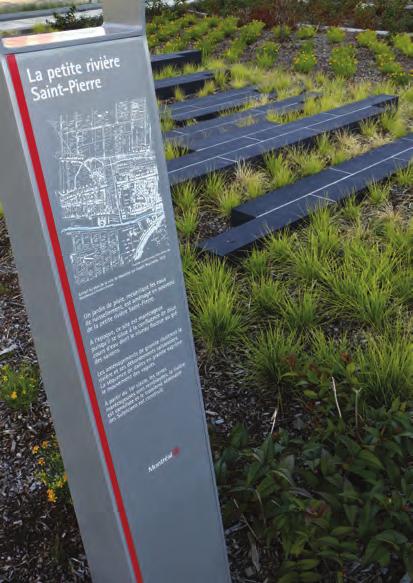
26 3. PUBLIC SPACE MONUMENTAL PUBLIC ART CONCEPTUAL SCHEME SEQUENCE OF POINTS OF INTEREST TOPOGRAPHICAL VARIATIONS GREENING OPERATION HISTORIC FABRIC
27 3. PUBLIC SPACE THRESHOLDS

28 3. PUBLIC SPACE SOUTHERN THRESHOLD Source - Jaume Plensa

29 3. PUBLIC SPACE NORTHERN THRESHOLD Dendrites - Michel de Broin

30 3. PUBLIC SPACE THRESHOLDS CENTRAL AXIS


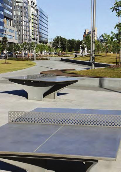
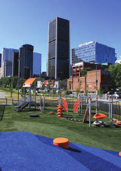
31 3. PUBLIC SPACE POINTS OF INTEREST
32 4. RESULTS


33 4. RESULTS MARCH 2014 JULY 2016 AUGUST 2016 JANUARY 2017 SEPTEMBER 2017 Unveiling: September 6 th, 2017 Completed within the set budget of CAN$ M

34 4. RESULTS DEMOLITION OF THE HIGHWAY DEMOLITION OF MORE THAN HALF A MILE OF ELEVATED EXPRESSWAY 47,000 TONS OF CRUSHED CONCRETE ON-SITE 95% REUSED ON-SITE AS FILL MORE THAN CAN$ 450,000 IN SAVINGS

35 4. RESULTS 2017 COMPLETION OF THE PUBLIC SPACE 6 ACRES OF NEW PUBLIC SPACE 300 NEW TREES 30,000 SHRUBS AND PERENNIALS
36 4. RESULTS DYNAMIC REAL-ESTATE SECTOR BUILDINGS CONSTRUCTED BETWEEN 2011 AND 2017 BUILDINGS UNDER CONSTRUCTION BUILDING CONSTRUCTION ANNOUNCED TOTAL OF CAN$ 2.14 BILLION IN INVESTMENTS SINCE 2011


37 4. RESULTS BEFORE 2011 AFTER 2017


38 4. RESULTS BEFORE 2011 AFTER 2017


39 4. RESULTS BEFORE 2011 AFTER 2017
 SUSTAINABLE URBAN TRANSPORTATION AWARD TRANSPORTATION ASSOCIATION OF CANADA (TAC) GRAND PRIX D EXCELLENCE EN TRANSPORT 2018 «INFRASTRUCTURES» ASSOCIATION QUÉBÉCOISE DES TRANSPORTS (AQTr)")
40 SITES CERTIFICATION GREEN BUSINESS CERTIFICATION INC. (GBCI) SUSTAINABLE URBAN TRANSPORTATION AWARD TRANSPORTATION ASSOCIATION OF CANADA (TAC) GRAND PRIX D EXCELLENCE EN TRANSPORT 2018 «INFRASTRUCTURES» ASSOCIATION QUÉBÉCOISE DES TRANSPORTS (AQTr) AWARDS FOR PLANNING EXCELLENCE 2018 «URBAN DESIGN» CANADIAN INSTITUTE OF PLANNERS (CIP) PRIX ÉLIXIR 2017 PROJECT MANAGEMENT INSTITUTE (PMI) MONTRÉAL PROJETBONAVENTURE.CA
41

42 2017 NEW OWNERSHIP: FROM PRIVATE RAILWAY COMPANY TO PUBLICLY OWNED METROPOLITAIN TRANSIT PROJECT

43
44 PHASE 1 PHASE 2 PHASE 3 Construction of civil infrastructure (combined sewers, sanitary sewers, water pipes and urban public utilities) Construction of the ramps and the boulevard Public space construction
45 2. TRANSPORT AND MOBILITY VEHICULAR TRAFFIC 3 STREET LANES TOWARD DOWNTOWN + ONE DEDICATED BUS LANE 4 STREET LANES TOWARD THE SOUTH SHORE + ONE DEDICATED BUS LANE AM PEAK HOUR: 4,000 VEHICLES PM PEAK HOUR: 4,800 VEHICLES
46 2. TRANSPORT AND MOBILITY PUBLIC TRANSIT DEDICATED BUS LANE TOWARD DOWNTOWN DEDICATED BUS LANE TOWARD THE SOUTH SHORE 1,900 BUSES/DAY

47 PUBLIC TRANSIT DEDICATED BUS LANE TOWARD DOWNTOWN
48 2017 SPACE STRUCTURE Sidewalks and streets Centre blocks (138ft) Sidewalk (20ft) rue Nazareth (56ft) Sidewalk (16ft) Arboretum (39ft) Central axis (26ft) Lawn area (39ft) Sidewalk (16ft) rue Duke (46ft) Sidewalk (19ft)

49 REPLACEMENT OF ALL UNDERGROUND INFRASTRUCTURE WATER PIPES: 1.36 MILE SEWERS: 1.55 MILE UNDERGROUND ELECTRICAL CONDUITS: 1.55 MILE NEW TELECOMMUNICATIONS INFRASTRUCTURE NEW GAS AND HEATING PIPES

50 SOIL REHABILITATION DECONTAMINATION OF 35,000 TONS OF SOIL
APPENDIX A: Complete Streets Checklist DRAFT NOVEMBER 2016
 APPENDIX A: Complete Streets Checklist DRAFT NOVEMBER 2016 Complete Streets Checklist MetroPlan Orlando s Complete Streets Checklist is an internal planning tool for staff to further implementation of
Complete Streets Successes, Opportunities, and Challenges
 Complete Streets Successes, Opportunities, and Challenges Juliet Walker, Transportation Planner, City of Portsmouth Rob Houseman, Director of Planning and Development, Town of Wolfeboro Chris Parker, Director
2.0 LANE WIDTHS GUIDELINE
 2.0 LANE WIDTHS GUIDELINE Road Engineering Design Guidelines Version 2.0.1 May 2018 City of Toronto, Transportation Services City of Toronto Page 0 Background In early 2014, Transportation Services initiated
West Dimond Blvd Upgrade Jodhpur Street to Sand Lake Road
 West Dimond Blvd Jodhpur St to Sand Lake CSS Transportation Project Summary Municipality of Anchorage Project # 05 005 Project Manager: John Smith, P.E. (MOA PM&E) Project Administrator: Julie Makela,
A Bicycle Network for a North American Metropolis: The Case of Montreal
 A Bicycle Network for a North American Metropolis: The Case of Montreal Marc Jolicoeur, Research Coordinator, Vélo Québec 1251 Rue Rachel Est, Montreal H2 J2J9, Canada marc-jolicoeur@velo.qb.ca Summary
Terwillegar Drive Expressway Draft Concept Plan
 Terwillegar Drive Expressway Draft Concept Plan Anthony Henday Drive to Whitemud Drive November 28 5:00-8:00 p.m. December 1 10:00 a.m. - 3:00 p.m. Let s Talk Today you can: Learn about the new direction
Transportation. Pages E-3 to E-145 PROPOSED FY CAPITAL IMPROVEMENT PLAN (CIP) CCCRC Presentation Thursday, June 14, 2018
 CCCRC Presentation Thursday, June 14, 2018") PROPOSED FY 2019-2028 CAPITAL IMPROVEMENT PLAN (CIP) Pages E-3 to E-145 CCCRC Presentation Thursday, June 14, 2018 in the CIP Continues Arlington s commitment to a transportation system that expands travel
PROPOSED FY 2019-2028 CAPITAL IMPROVEMENT PLAN (CIP) Pages E-3 to E-145 CCCRC Presentation Thursday, June 14, 2018 in the CIP Continues Arlington s commitment to a transportation system that expands travel
INNER LOOP EAST. AIA Rochester Annual Meeting November 13, 2013 TRANSFORMATION PROJECT. Bret Garwood, NBD Erik Frisch, DES
 INNER LOOP EAST TRANSFORMATION PROJECT AIA Rochester Annual Meeting November 13, 2013 Bret Garwood, NBD Erik Frisch, DES Why? We are building a city that encourages walking, biking and enjoying the outdoor
2045 Long Range Transportation Plan. Summary of Draft
 2045 Long Range Transportation Plan Summary of Draft Fredericksburg Area Metropolitan Planning Organization The George Washington Region includes the City of Fredericksburg and the counties of Caroline,
Building Great Neighbourhoods BELLEVUE AND VIRGINIA PARK
 Building Great Neighbourhoods BELLEVUE AND VIRGINIA PARK This is Meeting 2 Unfortunately, some residents in Bellevue and Virginia Park received the wrong information for this public open house (Meeting
9/25/2018. Multi-Modal Level of Service (MMLOS) Bianca Popescu, Transportation Planner
 Bianca Popescu, Transportation Planner") Multi-Modal Level of Service (MMLOS) Bianca Popescu, Transportation Planner 1 What is MMLOS? Is this a nice place to walk? Is this a nice place to bike? Is transit convenient? Bottom line - Are there options
Multi-Modal Level of Service (MMLOS) Bianca Popescu, Transportation Planner 1 What is MMLOS? Is this a nice place to walk? Is this a nice place to bike? Is transit convenient? Bottom line - Are there options
CONTEXT SENSITIVE STREETS STANDARDS COMMITTEE
 CONTEXT SENSITIVE STREETS STANDARDS COMMITTEE February 23, 2015 Prepared by: Denise Chaplick, AICP City Jacksonville Bicycle and Pedestrian Coordinator Source: NCDOT Complete Streets Planning and Design
TOWN OF PORTLAND, CONNECTICUT COMPLETE STREETS POLICY
 TOWN OF PORTLAND, CONNECTICUT COMPLETE STREETS POLICY I. VISION, GOALS & PRINCIPLES VISION To improve the streets of Portland making them safer and more accessible for all users including pedestrians,
Engineering - Bicycle and Pedestrian
 Capital Improvement Plan Project Summary # Bikeways Program 781,000 860,000 900,000 933,000 933,000 933,000 # Cannonball Path 1,200,000-780,000 - - - # Capital City Trail - 70,000 - - 910,000 - # Goodman
Gerald Ollivier Lead Transport Specialist World Bank, New Delhi. Transforming Cities through Integrated Planning Corridor Scale
 Gerald Ollivier Lead Transport Specialist World Bank, New Delhi Transforming Cities through Integrated Planning Corridor Scale JOB ACCESSIBILITY: ZHENGZHOU A: LINE 1, 2, AND 3 AND WALKING: 12% B. SCENARIO
2016 I-30 CROSSING ARKANSAS BOULEVARD KEY IDEAS OF PLAN B:
 KEY IDEAS OF PLAN B: Transportation shall support all parts of the cities and improve the quality of life downtown. There is no need to shorten commuting time at rush hour by a few minutes at the risk
5 CIRCULATION AND STREET DESIGN
 5 CIRCULATION AND STREET DESIGN This chapter describes circulation and streetscape improvements proposed for the Northwest Chico Specific Plan Area. It includes detailed design specifications for existing
Ocean Park Boulevard Streetscape Improvement Project Alternatives & Trade Offs
 City Council Study Session January 27, 2009 Ocean Park Boulevard Streetscape Improvement Project Alternatives & Trade Offs Scope of Work Purpose of Tonight s Meeting Review work to date and direct staff
Section 7 Complete Green Street Guidelines DRAFT
 Section 7 Complete Green Street Guidelines DRAFT 1 Section: 7.0 COMPLETE GREEN STREET GUIDELINES These guidelines serve as options to mitigate the environmental impact of a project as well as guide the
Building Great Neighbourhoods BONNIE DOON
 Building Great Neighbourhoods BONNIE DOON We Are Here Today To Explain the Neighbourhood Renewal Process Show you the Westwood Preliminary Design Ask for local knowledge Highlight the Local Improvement
10.0 CURB EXTENSIONS GUIDELINE
 10.0 CURB EXTENSIONS GUIDELINE Road Engineering Design Guidelines Version 1.0 March 2017 City of Toronto, Transportation Services City of Toronto Page 0 Background In early 2014, Transportation Services
APPENDIX 2 LAKESHORE ROAD TRANSPORTATION REVIEW STUDY EXECUTIVE SUMMARY
 APPENDIX 2 LAKESHORE ROAD TRANSPORTATION REVIEW STUDY EXECUTIVE SUMMARY Appendix 2 City of Mississauga Lakeshore Road FINAL REPORT Transportation Review Study December 2010 EXECUTIVE SUMMARY Study Purpose
Active Transportation Infrastructure Investment A Business Case
 Active Transportation Infrastructure Investment A Business Case In 2016, the Real Estate Foundation awarded the Capital Regional District a $50,000 grant for Shifting Gears: Land Use Change through Active
2015 Urban Mobility Scorecard. Scott Weber, Transportation Planner & Analyst James Winters, Regional Planner & Policy Analyst
 2015 Urban Mobility Scorecard Scott Weber, Transportation Planner & Analyst James Winters, Regional Planner & Policy Analyst Introduction 1. Congestion Trends 2. Compounding Problems 3. Possible Solutions
Welcome. If you have any questions or comments on the project, please contact:
 Welcome This drop-in public open house is intended to provide information about the Bay Street bike lanes project. This project proposes a dedicated cycling facility along Bay Street between Aberdeen Avenue
PLAN 20 PUBLIC TRANSPORT NETWORK
 KEY Bus Route / 400m Coverage Existing Recommended Secondary Potential Secondary Indicative Stop Locations Principle Standard Sub-regional Transit Corridor Reservation PLAN 0 PUBLIC TRANSPORT NETWORK Date:
Omaha s Complete Streets Policy
 Omaha s Complete Streets Policy (Adopted August 2015) VISION To create great places and enhance our quality of life, the City of Omaha will provide safe, accessible streets for all users. Complete Streets
City of Madison: 2017 Capital Budget Capital Improvement Plan
 Capital Improvement Plan Project Summary Bikeways Program 779,000 751,000 630,000 670,000 703,000 703,000 Cannonball Path 210,000 - - 730,000 - - Cap City Trail 1,140,000-360,000 - - 910,000 Ice Age Junction
Goodlettsville Bicycle and Pedestrian Plan Executive Summary
 Goodlettsville Bicycle and Pedestrian Plan July 2010 In Cooperation with the Nashville Area Metropolitan Planning Executive Organization Summary Introduction Progressive and forward thinking communities
Presentation to the City of Ottawa Transit Commission. February 20, 2013
 Presentation to the City of Ottawa Transit Commission February 20, 2013 Background 1994: Comprehensive development plan for road networks and public transit(sto, MTQ,NCCandCUO) 1994: Commuter train study
CITY OF VAUGHAN EXTRACT FROM COUNCIL MEETING MINUTES OF OCTOBER 30, 2012
 CITY OF VAUGHAN EXTRACT FROM COUNCIL MEETING MINUTES OF OCTOBER 30, 2012 Item 31, Report No. 39, of the Committee of the Whole, which was adopted without amendment by the Council of the City of Vaughan
Reversible Elevated Express Lanes. A Solution for Urban Traffic Congestion
 Lee Roy Selmon Crosstown Expressway Reversible Elevated Express Lanes A Solution for Urban Traffic Congestion Martin Stone, Ph.D., AICP Director of Planning Tampa-Hillsborough Expressway Authority Pensacola
SD Highway 50 in Yankton (4 TH Street) Reconstruction Project NH 0050(99)381 PCN By Josh Larson McLaury Engineering Inc.
 Reconstruction Project NH 0050(99)381 PCN By Josh Larson McLaury Engineering Inc.") SD Highway 50 in Yankton (4 TH Street) Reconstruction Project NH 0050(99)381 PCN 6926 By Josh Larson McLaury Engineering Inc. Project Limits SD 50 from Broadway to Burleigh and from Marne Creek to Archery
SD Highway 50 in Yankton (4 TH Street) Reconstruction Project NH 0050(99)381 PCN 6926 By Josh Larson McLaury Engineering Inc. Project Limits SD 50 from Broadway to Burleigh and from Marne Creek to Archery
TRANSPORTATION & MOBILITY
 TRANSPORTATION & MOBILITY ROADWAY SYSTEM There are approximately 40 miles of roadways in Manitou Springs. For planning purposes, roadways are typically assigned a functional classification which defines
CITY OF SEATTLE RESOLUTION. WHEREAS, the Washington State Department of Transportation (WSDOT) led the Seattle
 led the Seattle") SDOT SR0 Design Refinements RES August, 0 Version #D 0 CITY OF SEATTLE RESOLUTION..title A RESOLUTION relating to the State Route 0, Interstate to Medina Bridge Replacement and High Occupancy Vehicle Project;
SDOT SR0 Design Refinements RES August, 0 Version #D 0 CITY OF SEATTLE RESOLUTION..title A RESOLUTION relating to the State Route 0, Interstate to Medina Bridge Replacement and High Occupancy Vehicle Project;
2.2 TRANSIT VISION 2040 FROM VISION TO ACTION. Emphasize transit priority solutions STRATEGIC DIRECTION
 TRANSIT VISION 2040 FROM VISION TO ACTION TRANSIT VISION 2040 defines a future in which public transit maximizes its contribution to quality of life with benefits that support a vibrant and equitable society,
State Highway 16 Kuna-Mora Road to Ada/Gem County Line
 Background State Highway 16 is the main commuter route from Gem County to the Treasure Valley. An increase in traffic and accidents on this highway have been a concern for several years, and the Idaho
Purpose: Financial Implications and Impact Statement: It is estimated that the cost to implement:
 Various Modifications Lower Jarvis Street and Lake Shore Boulevard East; Lower Jarvis Street, east side, between Lake Shore Boulevard East and The Esplanade - 45-77 Lower Jarvis Street; and Lower Jarvis
Bicycle and Pedestrian Advisory Committee (BPAC) November 21, 2013
 November 21, 2013") Bicycle and Pedestrian Advisory Committee (BPAC) November 21, 2013 OVERALL LAND USE CONCEPT Overall Broadway Valdez District: 95.5 acres (35.1 acres right-of ways + 60.4 acres developable land) Plan Subareas:
Bicycle and Pedestrian Advisory Committee (BPAC) November 21, 2013 OVERALL LAND USE CONCEPT Overall Broadway Valdez District: 95.5 acres (35.1 acres right-of ways + 60.4 acres developable land) Plan Subareas:
State Highway 16/McDermott Road Kuna-Mora Road to Ada/Gem County Line
 Background State Highway 16 is the main commuter route from Gem County to the Treasure Valley. An increase in traffic and accidents on this highway have been a concern for several years, and the Idaho
State Highway 16 Kuna-Mora Road to Ada/Gem County Line
 Background Update! (February 2018): This project has been partially funded; see below. State Highway 16 is the main commuter route from Gem County to the Treasure Valley. An increase in traffic and accidents
CASE STUDY WALKABLE WASHINGTON WHO WE ARE & WHAT WE DO CITY OF BOTHELL DOWNTOWN REVITALIZATION PLAN BOTHELL, WA
 LKABLE SHNGTON Transformation towards walkability is taking place all over the state of Washington. From urban, suburban and small town initiatives, the program showcases the effects of a renewed focus
Environment and Public Works Committee Presentation
 Mixed Use Centers Complete Streets Guidelines Project Environment and Public Works Committee Presentation December 10, 2008 Project Objectives: Conduct an inter-departmental and agency process to study
Design of Stanley Park S-Curve
 ADMINISTRATIVE REPORT Date: May 4, 2001 TO: FROM: Author/Local: F. Klotzbach/7118 RTS NO. 01644 CC File No. Standing Committee on Transportation and Traffic General Manager of Engineering Services, in
Mark Malone, P.E. SD DOT
 Mark Malone, P.E. SD DOT SD10 Grading & Surfacing From 8 th Ave W to 8 th Ave E 1 mile plus transition lengths Complete Urban Reconstruction Grading, C&G, Storm Sewer, Sidewalk, Concrete Surfacing Railroad
Living Streets Policy
 Living Streets Policy Introduction Living streets balance the needs of motorists, bicyclists, pedestrians and transit riders in ways that promote safety and convenience, enhance community identity, create
RZC Appendix 8A Marymoor Subarea Street Requirements
 RZC Appendix 8A Marymoor Subarea Street Requirements For additional design details for Marymoor Subarea infrastructure, refer to the 2017 Marymoor Subarea Infrastructure Planning Report. STREET REQUIREMENTS
PLANNING FOR SUSTAINABLE PEDESTRIAN INFRASTRUCTURE NALIN SINHA INITIATIVE FOR TRANSPORTATION & DEVELOPMENT PROG. (ITD), DELHI
, DELHI") PLANNING FOR SUSTAINABLE PEDESTRIAN INFRASTRUCTURE NALIN SINHA INITIATIVE FOR TRANSPORTATION & DEVELOPMENT PROG. (ITD), DELHI India s Road Network 5 million kms: Total road length 2.6 mn kms: Surfaced
PLANNING FOR SUSTAINABLE PEDESTRIAN INFRASTRUCTURE NALIN SINHA INITIATIVE FOR TRANSPORTATION & DEVELOPMENT PROG. (ITD), DELHI India s Road Network 5 million kms: Total road length 2.6 mn kms: Surfaced
Ocean Park Boulevard Green Street Project Alternatives & Trade Offs
 Planning Commission March 4, 2009 Ocean Park Boulevard Green Street Project Alternatives & Trade Offs Purpose of Tonight s Meeting Review concept plans and options Provide input on alternatives and trade-offs
WELCOME. Stakeholder Involvement Group Meeting #2 Round Lake Public Works October 24, 2018
 WELCOME Stakeholder Involvement Group Meeting #2 Round Lake Public Works October 24, 2018 MEETING AGENDA 1. Welcome and Introductions 2. Study Progress Update 3. Problem Statement 4. Technical Analysis
ACTIVE TRANSPORTATION
 ACTIVE TRANSPORTATION Mobility 2040 Supported Goals Improve the availability of transportation options for people and goods. Support travel efficiency measures and system enhancements targeted at congestion
MAKE YOUR PLACE IN CHANNELSIDE
 MAKE YOUR PLACE IN CHANNELSIDE INTRODUCTION PROJECT LIMITS Channelside Drive from Cumberland Ave to Kennedy Boulevard EXISTING CONDITIONS EXISTING CONDITIONS CHANNELSIDE DRIVE FROM E. CUMBERLAND AVENUE
Proposed. City of Grand Junction Complete Streets Policy. Exhibit 10
 Proposed City of Grand Junction Complete Streets Policy Exhibit 10 1 City of Grand Junction Complete Streets Policy Vision: The Complete Streets Vision is to develop a safe, efficient, and reliable travel
Canada s Capital Region Delegation to the Velo-City Global 2010 Conference
 Canada s Capital Region Delegation to the Velo-City Global 2010 Conference Report of Findings from Visits, Meetings & Presentations In Amsterdam-Den Haag, Utrecht, Berlin & Copenhagen The Itinerary Copenhagen
ST. GEORGE STREET REVITALIZATION: ROAD DIETS IN TORONTO
 Case Studies in Sustainable Transportation TORONTO, ONTARIO CASE STUDY 30 ST. GEORGE STREET REVITALIZATION: ROAD DIETS IN TORONTO Organization Status St. George Street revitalization completed Other lane
SANTA MONICA BOULEVARD CORRIDOR
 CIRCULATION ELEMENT WHITE PAPER NO. 3 SANTA MONICA BOULEVARD CORRIDOR INTRODUCTION From the 1930s to the beginning of Los Angeles freeway era, Santa Monica Boulevard, (previously Route 66, the Beverly
Agenda. Overview PRINCE GEORGE S PLAZA METRO AREA PEDESTRIAN PLAN
 PRINCE GEORGE S PLAZA METRO AREA PEDESTRIAN PLAN May 28, 2008 Agenda Welcome and introductions Project overview and issue identification Planning context and strengths Design challenges and initial recommendations
Hennepin Avenue Reconstruction Washington Avenue to 12 th Street
 CITY OF MINNEAPOLIS Hennepin Avenue Reconstruction Washington Avenue to 12 th Street April 2016 1 Upcoming Opportunities Public Meeting #2 April 25, 2016 Minneapolis Central Library Doty Board Room Repeat
Balancing Operation & Safety for Motorized and Non-Motorized Traffic
 Balancing Operation & Safety for Motorized and Non-Motorized Traffic Brian Willham, PE, PTOE Iowa Director - MOVITE June 30, 2014 Learning Objectives: When & Why should we measure the performance of complete
Simulating Street-Running LRT Terminus Station Options in Dense Urban Environments Shaumik Pal, Rajat Parashar and Michael Meyer
 Simulating Street-Running LRT Terminus Station Options in Dense Urban Environments Shaumik Pal, Rajat Parashar and Michael Meyer Abstract The Exposition Corridor transit project is a light rail project
Thoreau Path Master Plan Final Draft. prepared for: The Boston Redevelopment Authority West End Community November 2007
 Thoreau Path Master Plan Final Draft prepared for: The Boston Redevelopment Authority West End Community November 2007 Introduction Carol R. Johnson Associates ( CRJA ) was retained by the Boston Redevelopment
Seeking highest traffic-volume intersections for your OOH campaigns?
 Seeking highest traffic-volume intersections for your OOH campaigns? Step One: broaden your horizon. Check out the maps of Toronto, Montreal, Vancouver and Ottawa below to see that drivers are not concentrated
Bicycle and Pedestrian Connectivity Study. Old Colony Planning Council
 Bicycle and Pedestrian Connectivity Study Old Colony Planning Council Outline Why consider bike/peds in road designs? Why are measures needed? Connecting Land Use with Transportation Evaluation Tools:
DON MILLS-EGLINTON Mobility Hub Profile
 Mobility Hub Profile Dundas Don Mills-Eglinton West-Bloor Anchor Hub Gateway Hub N MOBILITY HUBS: Places of connectivity between regional and rapid transit services, where different modes of transportation
TRAVEL PLAN: CENTRAL EUROPEAN UNIVERSITY CAMPUS REDEVELOPMENT PROJECT TRAVEL PLAN. Central European University Campus Redevelopment Project.
 TRAVEL PLAN Central European University Campus Redevelopment Project Page 1 Table of Contents Introduction... 3 Background... 7 Building Users... 7 Transportation in Community Consultation... 7 Summary
City of Seattle Edward B. Murray, Mayor
 City of Seattle Edward B. Murray, Mayor Department of Transportation Scott Kubly, Director Eastlake Community Council 117 E Louisa St. #1 Seattle, WA 98102-3278 January 28, 2016 RE: Roosevelt to Downtown
NJDOT Complete Streets Checklist
 Background The New Jersey Department of Transportation s Complete Streets Policy promotes a comprehensive, integrated, connected multi-modal network by providing connections to bicycling and walking trip
Roosevelt Estates Neighborhood Improvements
 Roosevelt Estates Neighborhood Improvements Transportation Alternatives Application May 5 th, 2016 Qualifying Activities Construction of on-road and off-road trail facilities for pedestrians, bicyclists,
York Region Population and Employment Growth
 March 1, 2016 1 York Region Population and Employment Growth York Region needs to comply with The Provincial Growth Plan and new forecasts introduced to 2036 and 2041 2 Regional Official Plan Review York
# Southeastern Wisconsin Regional Freeway System Reconstruction Study and Preliminary Recommended Plan
 #70421 Southeastern Wisconsin Regional Freeway System Reconstruction Study and Preliminary Recommended Plan Public Information Meetings and Hearings May June 2002 1 Reason for Freeway System Study 270-mile
Designing Streets for Transit. Presentation to NACTO Designing Cities Kevin O Malley Managing Deputy Commissioner 10/24/2014
 Designing Streets for Transit Presentation to NACTO Designing Cities Kevin O Malley Managing Deputy Commissioner 10/24/2014 Chicago -- Streets for Transit TODAY Jeffery Jump Transit Signal Priority Central
Central Avenue Corridor Study FPID Number:
 Central Avenue Corridor Study FPID Number: 437932-1-18-01 City Commission Presentation 1 March 27, 2018 Meeting Agenda 1. Introductions 2. Project Overview 3. Opportunity for Economic Development 4. Healthy
Temporal and Spatial Variation in Non-motorized Traffic in Minneapolis: Some Preliminary Analyses
 Temporal and Spatial Variation in Non-motorized Traffic in Minneapolis: Some Preliminary Analyses Spencer Agnew, Jason Borah, Steve Hankey, Kristopher Hoff, Brad Utecht, Zhiyi Xu, Greg Lindsey Thanks to:
EXHIBIT B-1 PROJECT DESCRIPTION. Phase 1 of the Preferred Alternative
 EXHIBIT B-1 PROJECT DESCRIPTION Phase 1 of the Preferred Alternative The Transform 66 Public-Private Partnership (P3) Project (the Project ) means the Phase 1 of the Preferred Alternative components of
HARRISON STREET/OAKLAND AVENUE COMMUNITY TRANSPORTATION PLAN
 HARRISON STREET/OAKLAND AVENUE Community Workshop #4: Draft Plan Review December 3, 2009 D E S I G N, C O M M U N I T Y & E N V I R O N M E N T INTRODUCTIONS Key Project Staff: Alisa Shen, Project Manager,
SOCIALLY AND ENVIRONMENTALLY SUSTAINABLE URBAN TRANSPORT
 SOCIALLY AND ENVIRONMENTALLY SUSTAINABLE URBAN 1 Not only for clean air, but for basic human rights, those without cars must also be able to move without fear of being killed. 2 Bogotá is far from being
March, 2017 Christophe Najdovski, Deputy Mayor of Paris for transport, street network, mobility and public space. Roads and Mobility Parisian Policy
 March, 2017 Christophe Najdovski, Deputy Mayor of Paris for transport, street network, mobility and public space Roads and Mobility Parisian Policy Part 1 - Background Paris and its agglomeration, institutionnal
MEETING Agenda. Introductions. Project Overview. Key Study Components. Alternative Station Concepts. Preferred Station Concept. Next Steps.
 City GARLAND Council ROADVISION Briefing STUDY VISION STUDY Dallas, TX April 8, 2010 1 1 MEETING Agenda Introductions Project Overview Key Study Components Alternative Station Concepts Preferred Station
PRINCE GEORGE S PLAZA METRO AREA PEDESTRIAN PLAN
 PRINCE GEORGE S PLAZA METRO AREA PEDESTRIAN PLAN May 28, 2008 Agenda Welcome and introductions Project overview and issue identification Planning context and strengths Design challenges and initial recommendations
South King County High-Capacity Transit Corridor Study
 HIGH-CAPACITY TRANSIT CORRIDOR STUDY South King County Corridor South King County High-Capacity Transit Corridor Study Corridor Report August 2014 South King County High Capacity Transit Corridor Report
TRANSPORTATION TRAINING TOPICS. April 6, 2010
 TRANSPORTATION TRAINING TOPICS April 6, 2010 Roles of Transportation Providers Context and Policy Makers Division of Transportation and Traffic Other City Operations Other Transportation Operators CMA
e. 173rd/AVALON bicycle boulevard Shaker Heights Review Meeting - May 9, 2013
 e. 173rd/AVALON bicycle boulevard Shaker Heights Review Meeting - May 9, 2013 Transforming a neighborhood barrier into Greater Cleveland s First Bicycle Boulevard Project Schedule Phase 1 Site Visit (Documentation
Crystal City Citizen Review Council Meeting. July 10, 2013
 Crystal City Citizen Review Council Meeting July 10, 2013 Topics to be covered Overview of Crystal City Transportation Projects Capital Program Investments Regional Coordination 9 Program Overview Crystal
Proposed Bridge Street East Bicycle Lanes Public Open House Thursday, April 27, 2017
 WELCOME Proposed Bridge Street East Bicycle Lanes Public Open House Thursday, April 27, 2017 Purpose of the Open House The purpose of this Open House is to gain public input on the bicycle lanes proposed
Walkable Cities. A Presentation by Michalis Lambrinos Ministry of Transport, Communications and Works
 Walkable Cities A Presentation by Michalis Lambrinos Ministry of Transport, Communications and Works Contents What Makes a City Walkable Why is Walkability Important The Theory of Walkability Restrict
CPC Parking Lot Riverside Drive. Transportation Rationale
 CPC Parking Lot Transportation Rationale Prepared By: NOVATECH Suite 200, 240 Michael Cowpland Drive Ottawa, Ontario K2M 1P6 September 2015 Novatech File: 114093 Ref: R-2015-153 Table of Contents 1.0 INTRODUCTION...
Transportation Planning Division
 Transportation Planning Division Presentation Outline Study Tasks Recap of Previous Meetings Data Collected Focus Areas within Study Limits Design Principles Tool Box Recommended Concepts Schedule Moving
Building Great Neighbourhoods QUEEN ALEXANDRA
 Building Great Neighbourhoods QUEEN ALEXANDRA We are here today to Explain how the City is investing in improving your neighbourhood and how your neighbourhood will be improved to meet current City standards.
Transform 66 Project February 4, 2016 Partnering Conference Michigan Department of Transportation American Council of Engineering Companies
 Transform 66 Project February 4, 2016 Partnering Conference Michigan Department of Transportation American Council of Engineering Companies Susan Shaw, PE, CCM, DBIA Megaprojects Director Northern Virginia
Zlatko Krstulich, P.Eng. City of O9awa
 Zlatko Krstulich, P.Eng. City of O9awa 1. Introduction to the Ontario Traffic Manual Series 2. What is OTM Book 18: Bicycle Facilities? 3. Study / Committee Team Members 4. Brief overview of the content
RESOLUTION NO ?? A RESOLUTION OF THE CITY OF NEPTUNE BEACH ADOPTING A COMPLETE STREETS POLICY
 RESOLUTION NO. 2018-?? A RESOLUTION OF THE CITY OF NEPTUNE BEACH ADOPTING A COMPLETE STREETS POLICY WHEREAS, safe, convenient, and accessible transportation for all users is a priority of the City of Neptune
FY Transportation Capital Improvement Plan Update Arlington Committee for Transportation Choices
 FY 2017-2026 Transportation Capital Improvement Plan Update Arlington Committee for Transportation Choices November 1, 2017 Forecasted Growth Arlington continues to grow with a shift towards multi-family
San Bernardino County Non-Motorized Transportation Plan - Chapter 5
 City of Upland Population 76,106 City Overview The City of Upland was incorporated on May 15, 1906, after previously being named North Ontario. The City was originally established as an irrigation colony
Improving Mobility Without Building More Lanes
 Improving Mobility Without Building More Lanes By Mike Salisbury and Will Toor July 2017 Copyright 2017 by Southwest Energy Efficiency Project. All rights reserved. Photo: Courtesy of the Denver Post Anyone
Bicycle Master Plan Goals, Strategies, and Policies
 Bicycle Master Plan Goals, Strategies, and Policies Mobilizing 5 This chapter outlines the overarching goals, action statements, and action items Long Beach will take in order to achieve its vision of
Complete Streets 101: The Basics
 Complete Streets 101: The Basics Michigan Municipal League - Capital Conference March 21, 2017 Chip Smith, AICP - Senior Planner - Wade Trim Inc. and City Council member City of Ann Arbor 2017 MML Capital
Building Great Neighbourhoods LANSDOWNE
 Building Great Neighbourhoods LANSDOWNE We are here today to Explain how the City is investing in improving your neighbourhood and how your neighbourhood will be improved to meet current City standards.
SR-203 Sidewalks and Town-Wide Mobility Improvements. Town Council Presentation September 7, 2016
 SR-203 Sidewalks and Town-Wide Mobility Improvements Town Council Presentation September 7, 2016 SR-203 Sidewalks and Town- Wide Mobility Improvements SR-203 Sidewalks and Appurtenances Town-Wide Mobility
COWETA HIGH SCHOOL AND EAST HIGHWAY 51
 COWETA HIGH SCHOOL AND EAST HIGHWAY 51 Lack of sidewalks along Ben Lumpkin Rd. Lack of crosswalks and ramps at intersection. Hwy 51 is wide to cross as a pedestrian. No ADA compliance or connection to
Complete Streets Policy DAVID CRONIN, P.E., CITY ENGINEER
 Complete Streets Policy DAVID CRONIN, P.E., CITY ENGINEER Complete Streets City Commission adopted a Complete Streets policy in 2012 Complete Streets are road networks that are designed for all users: