Katie Franks, Project Manager Planning and Community Development. Historic Preservation Northwest
|
|
|
- Laurence Grant
- 5 years ago
- Views:
Transcription


1 Katie Franks, Project Manager Planning and Community Development Historic Preservation Northwest
2 All areas not previously surveyed in the Sehome Neighborhood


3 Sehome History Group, 1999 Two years research At Home on the Hill Sehome Hill National Historic District, 2001 It made us all look at our neighborhood in a different way Dar New, Sehome Resident
4 National Register of Historic Places National Park Service Honorary no protection no regulations unless federal funds involved Incentives property values grow grant fund eligibility tax incentives (income properties)


5 National Register of Historic Places National Park Service Honorary no protection no regulations unless federal funds involved It was a huge shot in the arm for neighborhood self-esteem Merrill Peterson, Sehome Resident Incentives property values grow grant fund eligibility tax incentives (income properties)

6 Capture a Snapshot in Time Identify historic buildings & districts Share historical information Inform future planning efforts Council Legacy Sense of Place Preserve historic & cultural resources
7 Survey Team Historic Preservation Northwest Dave Pinyerd Bernadette Niederer Lynette Felber Kolby LaBree City of Bellingham Kate Newell, GIS Analyst Jeff Jewell, Photo Archivist Brent Bode, Intern


8 Sehome Neighborhood Historic Building Survey Report July 23, 2013

9 Sehome History

10 Whatcom vs. Sehome

11 .l - - 'r Sehome 1859

12 Three Geographical Areas
13 Sehome Influences Bellingham Bay Coal Company ( ) Frasier Gold Rush in British Columbia (1858) Sehome Dock (July 7,1858) Sehome School (1861)

14 Sehome Dock

15 Early Sehome Elk Street Development 1890s 1885


16 Bellingham Bay Improvement Company ( )

")
17 Real Estate Boom ( )
")
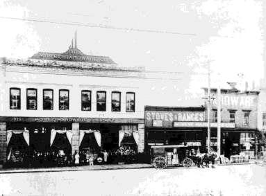
18 Commercial and Banking Corridor Elk and Holly Streets Pike Block (1891)

19 Main (Elk) Street Line (1892) North Garden Street Line (1892)

20 N. Garden Street: A Pedestrian Suburb

21 Edward Fischer/J.J. Donovan House 1201 N. Garden St.


22 Julius H. Bloedel House 1020 N. Garden St. Bernard & Anna Montague House 1030 N. Garden St.


23 Peter P. Lee House 900 N. Garden St. Chris Lee House 906 N. Garden St.

24 1920s: Hotel and Commercial Corridor

25 Apartment Houses The Molly Trezise 806 High St.
 1011")

26 The Kulshan (1919) 1011 High St. The Alamo (1927) 412 E. Maple

27 Western Washington University Expansion


28 St. Luke s Hospital


29 St. Luke s Expansions

30 State Street: Up the Hill 510 N State Street Church of the Assumption Rectory


31 512 N State Street The William F. and Elizabeth Roehl House Roehl Bros. State Street 1890s


32 528 N State Street Thomas S. and Amelia Dahlquist House

33 The Armory 525 N State Street


34 Roller Rink

35 Samish Way


36 1950 aerial showing future route of I-5


37 1963


38 Automobile Era

39 Bill McDonald Parkway, c.1967

40 Volkswagon Dealership

41 Sehome High School site

42
43


44 3310 Abbott Street The Ludwig and Albina Laznicka House Moved from 1116 Jersey Street in S 34 th Street Moved from 119 N Samish, site of Mobile Land Trailer Park in 1983 for strip-mall

45 Methodology

46 Office Phase 1 Assemble the Team - HPNW: David Pinyerd, Bernadette Niederer, Lynnette Felber, Kolby LaBree - C.O.B.: Katie Franks, Kate Newell, Brent Bode, Jeff Jewell Assemble the Data - Lists with Address, City Date - Maps of Survey Area Head Out!

47 Field Work Phase 1 Take one or more pictures

48 Field Work Phase High Street House Outbuilding
49 Field Work Phase 1 Note elements that are difficult to see on photos Siding: Wood Lap Windows: Wood Sash Foundation: Brick Check Date: 1908
50 Field Work Phase 1 Preliminary Evaluation of Alterations Plan: Slight Alteration Siding: Intact Windows: Intact
51 Office Phase 2 Enter information into database Add more from photos and maps Generate new field forms Style: Queen Anne Cottage Form: Workingman s Foursquare Plan Shape: Rectangular Roof: Hipped Roofing: Asphalt shingle Stories: 1

52 camera Field Work Phase 2 multi/1, honey comb eligible - dormer new - porch steps & post new rectangle Verify information Add details Preliminary eligibility determination? shed shed dormer roof on side none side?


53 Office Phase 3 More verification Current aerials and historic Sanborn Maps used to confirm plan, alterations, and construction date


54 camera More verification Current photo and assessor or historic photo compared to evaluate alterations Office Phase 3 new missing new missing 2004 assessor photo older assessor photo
55 Office Phase 3 All this is used to create a verbal physical description The house at 816 High Street is located in the Sehome neighborhood. The house is midblock and faces roughly west. It was built in 1908 (according to the County Assessor) and is a Workingman's Foursquare. The house has a rectangular plan and stands on a brick foundation. The one-story building has a hip roof clad in asphalt composition shingles. The boxed eave has a frieze board. A shed dormer on the northeast side of the house was apparently added when a small dormer with a single window, centered on the front hip of the façade was removed. The wall cladding is lap. The walls are trimmed with corner boards. The principal window type is wood sash with honeycomb paning in the upper sash. There is a fixed honeycomb accent window on the façade. In addition, a three-sided polygonal bay window is located on the northeast side of the house. The house has an inset porch supported by a single, narrow post. The entry is accessed by concrete steps with a metal rail. There appear to be slight alterations to the original plan. There is no discernable alteration to the original cladding and no discernable alteration to the original windows. Due to the degree of integrity of the original building, this resource would be considered eligible for the National Register under Criterion C.
56 Office Phase 3 and a Statement of Significance The house at 816 High Street is located on the former Vail DLC in the Sehome neighborhood. The building is located in the original town of Sehome. According to the Whatcom County Assessor's office, this resource was built in This construction date is supported by Sanborn maps and physical evidence. The building was constructed as a single family residence and still serves in that capacity. Criterion C (embodies the distinctive characteristics of a type, period, or method of construction, or that represents the work of a master, or that possesses high artistic values, or that represents a significant and distinguishable entity whose components may lack individual distinction) was the only criteria examined in the scope of this survey project. The building retains sufficient integrity to be potentially eligible for the National Register under Criterion C.

57 Office Phase 3 Result: The Completed Survey Form

58 Findings 545 parcels 354 principal structures 138 associated structures
59 Number Constructed Sehome Construction Dates Sehome Inventory Construction Dates Date Constructed

60 Sehome Styles Sehome Styles Mediterranean 1% Tudor 1% Vernacular 6% American Foursquare 12% Ranch 14% Queen Anne 21% Arts & Crafts 31% Other 1% Modern 5% Italianate 1% Colonial 4% Beaux Arts 1% Commercial 2%

61 Most Common Styles Queen Anne Anne

62 Foursquare Most Common Styles

63 Arts & Crafts Most Common Styles
64 Integrity vs. Condition Integrity How much original material remains Condition Physical state of resource
65 Three Main Elements Plan Siding Windows

66 Integrity Chart
67 Contributing vs. Non-Contrib Historic Contributing Historic Non-contributing Non-historic Non-contributing

68 Historic Contributing

69 Historic Non-Contributing

70 Non-Historic Non-Contributing
71 District Boundaries Historical Physical Temporal Integrity
72 Temporal boundaries Historical Boundaries
73 Temporal boundaries Physical Boundaries


74 Temporal boundaries Temporal Boundaries
75 Integrity Boundaries Current Use Versus Original Use % of Buildings Current Use Original Use Single-family res Multi-family res Use Church Civic Health Care Miscellaneous Original Use Current Use

76 Potential Historic District Historical Physical Temporal Integrity

77 Potential Historic District 63 principal structures 54 contributing properties
78 Sample Resources
79 Sample Resources
80 Sample Resources
81 Sample Resources


82 Sample Resources

83 Survey Information Available go to Type Historic Inventory in Search Bar Type City IQ in Search Bar Visit the Permit Center in City Hall Or for assistance contact Katie Franks
The History of the Recreation Residences on Mt. Hood National Forest. By Allie Wenzl Historian & Tribal Relations Advisor, Mt. Hood National Forest
 The History of the Recreation Residences on Mt. Hood National Forest By Allie Wenzl Historian & Tribal Relations Advisor, Mt. Hood National Forest Introduction I. History of Mt. Hood National Forest II.
Creswell Historic Buildings Survey Final Report
 Creswell Historic Buildings Survey Final Report Bohrnstedt Addition in 1911. Courtesy of the Creswell Area Historical Society. Prepared for the Lane Council of Governments by Historic Preservation Northwest
Cheltenham (82A-042) There is one Historic Site in Cheltenham: PG: 82A , Cheltenham Methodist Church & Cemetery, Crain Highway
 There is one Historic Site in Cheltenham: PG: 82A , Cheltenham Methodist Church & Cemetery, Crain Highway") Cheltenham (82A-042) Cheltenham is located in southern Prince George s County between Old Crain Highway (US Route 301) and Maryland Route 5. The survey area is located at the intersection of US 301, Surratts
Cheltenham (82A-042) Cheltenham is located in southern Prince George s County between Old Crain Highway (US Route 301) and Maryland Route 5. The survey area is located at the intersection of US 301, Surratts
Upper Marlboro (79-019)
") Upper Marlboro (79-019) Located in central Prince George s County, the Town of Upper Marlboro was established when the General Assembly of the Province of Maryland passed the Act for the Advancement of
Upper Marlboro (79-019) Located in central Prince George s County, the Town of Upper Marlboro was established when the General Assembly of the Province of Maryland passed the Act for the Advancement of
2018 Pedestrian and Bicycle and Safe Routes to School Application for Funding Page 1 of 31
 2018 Pedestrian and Bicycle and Safe Routes to School Application for Funding Page 1 of 31 2018 Pedestrian and Bicycle and Safe Routes to School Application for Funding Part 1: General Information Funding
Architectural Survey Data for Oregon Main Street Survey - Mosier
 (printout date: /5/009) Page of 5 s 803 nd Ave c.980 Synthetic Wood Siding 80 nd Ave c.900 Vertical Board Commercial (Type) -Part Block Department Store Comments: False front store - service garage 940
Proposed Holmby Westwood
 Proposed Holmby Westwood Historic Preservation Overlay Zone (HPOZ) Informational Open House and Official Public Hearing July 28, 2016 Agenda Workshop begins Visit Stations & View PowerPoint Presentation
FOR SALE. 202 Pacific Avenue, Bremerton, WA Historic Bremerton Trust and Savings Building
 FOR SALE 202 Pacific Avenue, Bremerton, WA 98337 Historic Bremerton Trust and Savings Building PROPERTY INFORMATION PRICE $1,750,000 BUILDING SIZE LOT SIZE 10,080 sq. ft. 4,792 sq. ft. (0.11 Acres) # OF
Heritage Research Report
 APPENDIX A Heritage Research Report Metro Marine June 2014 HERITAGE RESEARCH REPORT STATUS SHEET Street Address: 2508 Lakeshore Road West Roll Number: 2401020220073000000 Short Legal Description: PLAN
Analyzing Gainesville s Bicycle Infrastructure
 Mateo Van Thienen 1 DCP 2002: Intro to GIS II Final Project Paper Abstract: Analyzing Gainesville s Bicycle Infrastructure The main purpose of this project is to determine which areas within Gainesville
Samish-Maple-Ellis Corridor Pedestrian & Bicycle Safety Improvements. Bellingham City Council March 26, 2018
 1 Samish-Maple-Ellis Corridor Pedestrian & Bicycle Safety Improvements Bellingham City Council March 26, 2018 2009 Samish Way Urban Village Street Plans Multiple Plans Adopted by City Council 2009 Samish
EAST COAST FISHERIES 40 SW NORTH RIVER DRIVE
 EAST COAST FISHERIES 40 SW NORTH RIVER DRIVE Designation Report City of Miami REPORT OF THE CITY OF MIAMI PRESERVATION OFFICER TO THE HISTORIC AND ENVIRONMENTAL PRESERVATION BOARD ON THE POTENTIAL DESIGNATION
Scoping and Design Considerations for APS and ADA Curb Ramps. Adam Tyra, PE INDOT Greenfield District Traffic
 Scoping and Design Considerations for APS and ADA Curb Ramps Adam Tyra, PE INDOT Greenfield District Traffic Background and Perspective Scoping and Asset Management for traffic signals for INDOT s Greenfield
City Sidewalk Repair and Replacement Program
 City Sidewalk Repair and Replacement Program May 30, 2006 http://www.adventuregovernment.com Purpose Improve pedestrian safety Increase handicap accessibility Create a more walkable community Decrease
Appendix 10B Photographs (Including Historical Images)
") Lower Lee (Cork City) Drainage Scheme in association with Appendix 10B Photographs (Including Historical Images) Environmental Impact Statement APPENDIX 10B: PHOTOGRAPHS (INCLUDING HISTORICAL IMAGES) Plate
Lower Lee (Cork City) Drainage Scheme in association with Appendix 10B Photographs (Including Historical Images) Environmental Impact Statement APPENDIX 10B: PHOTOGRAPHS (INCLUDING HISTORICAL IMAGES) Plate
Multi-Modal Transportation Improvement Projects Identified by Neighborhood for the 20-year Planning Period
 2011 CITY CENTER MASTER PLAN UPDATE ADOPTED TRANSPORTATION ELEMENT PROJECT LIST FOR THE CBD, WATERFRONT, AND YORK, SEHOME, AND LETTERED STREETS NEIGHBORHOODS IMMEDIATELY ADJACENT TO CITY CENTER TRANSPORTATION
City Birmingham Multi-Modal Transportation Plan Visioning Workshop Results Meeting
 City Birmingham Multi-Modal Transportation Plan Visioning Workshop Results Meeting Monday, January 28, 2013 7:30 PM, City Hall Norman Cox, PLA, ASLA. Ann Arbor, Michigan. www.greenwaycollab.com Community
Brian McHugh, Buckhead Community Improvement District. SUBJECT: Wieuca Road at Phipps Boulevard Intersection Improvements Project
 MEMO TO: FROM: Brian McHugh, Buckhead Community Improvement District Jagan Kaja, AICP, WSP Parsons Brinckerhoff SUBJECT: Wieuca Road at Phipps Boulevard Intersection Improvements Project DATE: October
MARION COUNTY SURPLUS AUCTION - 11/02/2016. SALE RESULTS Prepared 10/30/2017
 Contact: County Tax Agent PO Box 96 141 St Andrews Ave (618) 656-5744 Edwardsville, IL 62025 www.iltaxsale.com Real Estate 1116001A 01-09-402-016 PATOKA 1116002A 01-09-402-018 PATOKA 1116003A 01-10-100-006
Pedestrian Project List and Prioritization
 To: Kyle Wagenschutz, City of Memphis CC: From: Anne Conlon and John Cock, Alta Planning + Design Date: December, 2014 Re: Project List Development (Task 3.1-3.2) and Project List Prioritization (Task
116TH STREET AND BROOKS SCHOOL ROAD ORDINANCE NO B
 116TH STREET AND BROOKS SCHOOL ROAD ORDINANCE NO. 031802B A Text Amendment to Ordinance No. 071000A - An Ordinance Establishing the 116th Street and Brooks School Road Planned Unit Development District
Fulton Market Streetscape
 Fulton Market Streetscape Ogden Avenue to Halsted Street Public Meeting Recommended Improvements December 10th, 2014 Meeting Purpose and Goals Present Existing Conditions Community Input and Charrette
Old Dominion Drive (Route 309) Pedestrian Safety Project Phase II. North Glebe Road to 38 th Street N
 Pedestrian Safety Project Phase II. North Glebe Road to 38 th Street N") Old Dominion Drive (Route 309) Pedestrian Safety Project Phase II North Glebe Road to 38 th Street N Prepared: 12/2010 The presentation you are about to review represents a 90 percent completed design.
Old Dominion Drive (Route 309) Pedestrian Safety Project Phase II North Glebe Road to 38 th Street N Prepared: 12/2010 The presentation you are about to review represents a 90 percent completed design.
Student Population Projections By Residence. School Year 2016/2017 Report Projections 2017/ /27. Prepared by:
 Student Population Projections By Residence School Year 2016/2017 Report Projections 2017/18 2026/27 Prepared by: Revised October 31, 2016 Los Gatos Union School District TABLE OF CONTENTS Introduction
San Jose Transportation Policy
 San Jose Transportation Policy Protected Intersections in LOS Policies to Support Smart Growth Presented by: Manuel Pineda City of San Jose Department of Transportation Bay Area Map San Francisco Oakland
POTTER HIGHLANDS OFFICE SPACE FOR LEASE
 POER HIGHLNDS SPCE FOR LESE wheeler block building 2150 W. 29th venue Space vailable: 679 SF - 6,642 SF Lease Rates: $29.00 - $35.00 SF Building Size: 32,855 Year Built: 1892 Stories: 6 Construction: Brick
Project Status Report
 Appendix A: Project Status Report Municipal Streetlight Redesign and Policy Development, Lebanon, NH Upper Valley Lake Sunapee Regional Planning Commission 10 Water Street, Suite 225 Lebanon, NH 03766
REAR YARDS - There shall be a rear yard no less than forty (40) feet.
 feet.") ARTICLE VII - RESIDENCE R-2 DISTRICT 700-PURPOSE - The purpose of the R-2 District is to permit the establishment of medium density one and two family dwellings. 701-PERMITTED USES - After obtaining a
ARTICLE VII - RESIDENCE R-2 DISTRICT 700-PURPOSE - The purpose of the R-2 District is to permit the establishment of medium density one and two family dwellings. 701-PERMITTED USES - After obtaining a
ata'ara A2tecretirr. e LFaierry Cl...4.C.ei-Y CO (.4-77Y
 ata'ara A2tecretirr. e LFaierry Cl...4.C.ei-Y114-15 CO (.4-77Y "trio //7,-Gern4--7-/cm: s7uo5-,ehre.57,4: gal.c...: XXXI Le.6-4L.' 77 /, /. /7 Virl 13_..-1: LO -5 -C1 LAKE OSWEGO 2S X'. le C. 5C EAinE:
Community Meeting February 27, 2007 Dorchester Avenue Transportation & Streetscape Improvements Action Plan February 27, 2007
 Community Meeting Tonight s Agenda 6:00 Introductions South Boston/Dot Ave Improvement Study Background 6:15 Consultant Introductions Review of Scope and Schedule Review of Proposed Corridor Wide Guidelines
Historic Resources Screening Survey
 Historic Resources Screening Survey for the City of Ojai Results and Methodology Report March 2011 City of Ojai Historic Resources Screening Survey Final Report Prepared for City of Ojai, California Historic
Katy I.S.D. Demographic Update
 Katy I.S.D. Demographic Update April 19, 2017 Primary vs. Secondary Data Sources Secondary Data: Texas State Data Center, Houston-Galveston Area Council of Governments, and many other entities use extrapolation
BETHEL ROAD AND SEDGWICK ROAD CORRIDOR STUDY
 DRAFT PLAN City Council Meeting August 14, 2017 STUDY AREA Sedgwick Corridor State Route 160, principal arterial with Class 3 access management designation, commuter and freight route, connection to SR
Blue Ribbon Commission Report Recommendations on Pedestrian and Bicycle Infrastructure Improvements
 Recommendations on Pedestrian and Bicycle Infrastructure Improvements July 2017 Plan Development: Our committee consisted of seven individuals appointed by the Mayor and Village Board. Those members included:
Trail Feasibility. 1. Introduction FINAL. October What s inside?
 VOLUSIA COUNTY MPO CITY OF PORT ORANGE FINAL Trail Feasibility October 2006 What s inside? 1 Introduction 2 Project Purpose & Scope 3 Physical Inventory & Assessment of Right-of- Way 4 Trail Concept Plan
Slide. Too close together; Don't like the garages in front; Front-facing garages are not nice; Bland; Looks like suburbs; Only see garages
 1 Slide Visual Preference Survey Results Like driveways and less density; Everything looks squeezed in; Street parking is a turn-off; East Coast look; I like the porches; Garages should be in alleys; Too
5. Automobile Circulation, Wayfinding and Signage
 5. Automobile Circulation, Wayfinding and Signage Policy: The City Center should have a balanced, safe, and interconnected circulation system that provides expanded travel opportunities for transit, pedestrian,
ALPHARETTA, GA FOR LEASE
 PROPERTY HIGHLIGHTS Approximately 18,283 SF two-story office building Up to 9,427 SF available for lease 6,377 RSF total contiguous space available (suite 200/210) Offered for lease at $15.50/SF full service
Methodology for Determining Pedestrian Activity Factors
 Where People Walk: Methodology for Determining Pedestrian Activity Factors Part I: Background on the WalkFirst Project The goal of the WalkFirst project is to improve walking conditions in San Francisco,
31. Rosses Point Mini-Plan
 County Development Plan 2017-2023 Volume 2, Chapter 31 Rosses Point Mini-Plan 31. Rosses Point Mini-Plan Village profile Rosses Point is a coastal settlement located approximately 8 km north-west of Sligo
Building 146/146A Engineering and Manufacturing Building. Historic American Buildings Survey Level I FINAL
 FINAL Building 146/146A Engineering and Manufacturing Building Historic American Buildings Survey Level I 2701 North Harbor Drive, San Diego, California 92101 Prepared for San Diego Unified Port District
Main Building and raft building viewed from the south side of the Oklahoma River. The white water Main Building anchors the development.
 Client: OKCMAPS Office Completion: April 2016 Scope: Main Building: 16,326 SF Raft Storage Building: 2,041 SF Kayak Storage Building: 1,348 SF Rotary Point Pavilion: 1,387 SF Cost: $45.2 M Awards: RIVERSPORT
2018 WILDLIFE MANAGEMENT PLAN
 2018 WILDLIFE MANAGEMENT PLAN 1 MEMORANDUM TO: FROM: Captain Daniel Wills Officer Dominic Wareham DATE: July 11, 2018 RE: 2018 Wildlife Management Plan CONTENTS I. 2017 Wildlife Management Report II. 2017
City of Darlington Beautification Report
 City of Darlington Beautification Report Approved by the City of Darlington Beautification Board February 2016 The New Downtown Darlington has seen many changes during the past decade with the rehabilitation
MINNESOTA HISTORIC PROPERTY RECORD PART I. PROPERTY IDENTIFICATION AND GENERAL INFORMATION
 MINNESOTA HISTORIC PROPERTY RECORD PART I. PROPERTY IDENTIFICATION AND GENERAL INFORMATION Common Name: Whitefish Creek Bridge Bridge Number: 3355 Identification Number: Location: Feature Carried: US 169
GIS Based Non-Motorized Transportation Planning APA Ohio Statewide Planning Conference. GIS Assisted Non-Motorized Transportation Planning
 The Purpose of GIS Assisted Network GIS Assisted Non-Motorized Transportation 2011 APA Ohio Statewide Conference Friday, 10:45 AM to Noon Focus on near-term projects wwwgreenwaycollabcom The purpose of
San Rafael School District. Task Force Meeting Notes. November 5, 2012
 San Rafael School District Task Force Meeting Notes November 5, 2012 Attendees (8) Wendi Kallins Program Director for Safe Routes to Schools; Laura Kelly Volunteer Liaison for Safe Routes to Schools; Leslie
South Jersey certainly has many of quality of life issues related to transportation. In spite of being a small state, the Garden State has the 3 rd
 This presentation summarizes an on-going study of commuter rail potential in Southern New Jersey. This study examines the 3 rail alignments that have been proposed by the Delaware River Port Authority
Figure 1 Front elevation. Figure 2 Rear elevation with two wings, each with gambrel roofs intersecting the main roof, but at a lower level.
 A private school in a picturesque New England town is the setting for our first case study in snow retention. This significant building (Figure 1), on the campus of a prestigious private school, houses
East Burke Transportation, Safety and Capacity Improvements
 East Burke Transportation, Safety and Capacity Improvements The purpose of this project is to increase mobility and improve safety for pedestrians, cyclists, and motor vehicles along VT Route 114 in the
ARTICLE V - AGRICULTURAL SUBURBAN ESTATE RESIDENTIAL - A- SER
 Adopted August 23, 2010 ARTICLE V - AGRICULTURAL SUBURBAN ESTATE RESIDENTIAL - A- SER 500-PURPOSE - The purpose of the A-SER District is: 1) to preserve and protect the decreasing supply of prime agricultural
3: 1470 Bronte Road, W.C. Inglehart Farm/Oakhurst
 1. Description of Property 3: 1470 Bronte Road, W.C. Inglehart Farm/Oakhurst Municipal Address 1471 Bronte Road Name (if applicable) W.C. Inglehart Farm, Oakhurst Legal Description PT LTS 31, 32 & 33,
A Walkability Study for Downtown Brunswick
 Alex Thompson and Sam Vitello E.S. 204 Semester Project-Final Paper A Walkability Study for Downtown Brunswick Introduction and Problem Statement The goal of our project was to analyze parking availability
Natick Comprehensive Master Plan PHASE I COMMUNITY MEETING. November 29, 2016
 Natick 2030+ Comprehensive Master Plan PHASE I COMMUNITY MEETING November 29, 2016 Tonight s Agenda Project Introduction Breakout group discussion of vision & goals: Land Use, Housing & Economic Development
Central Jersey Transportation Forum. March 2007
 Central Jersey Transportation Forum March 2007 Feasibility Analysis of BRT on Dinky Right of Way from Princeton Station to Alexander Rd. in West Windsor (west of Rt. 1) Study spurred by Princeton University's
Mapping Food Deserts : Access to Healthy Foods in Cities
 Mapping Food Deserts : Access to Healthy Foods in Cities Measuring Community Access Susan Kinne, Donald Patrick, Allen Cheadle, Todd Edwards CDC Disability and Health Team Food Desert Those areas of cities
AWEA State RPS Market Assessment Executive Summary
 AWEA State RPS Market Assessment 2013 Executive Summary Lead Author: John Hensley, Policy Analyst Contributions from: Emily Williams, Senior Policy Analyst Carl Levesque, clean energy communications consultant
ADOT Statewide Bicycle and Pedestrian Program Summary of Phase IV Activities APPENDIX B PEDESTRIAN DEMAND INDEX
 ADOT Statewide Bicycle and Pedestrian Program Summary of Activities APPENDIX B PEDESTRIAN DEMAND INDEX May 24, 2009 Pedestrian Demand Index for State Highway Facilities Revised: May 29, 2007 Introduction
Using GPS Data for Arterial Mobility Performance Measures
 Using GPS Data for Arterial Mobility Performance Measures Paul Czech, MnDOT Shawn Turner, TTI CTS Research Conference May 22, 2014 ~ St. Paul, MN Methodology & Results INRIX GPS Data + = Road Inventory
US 19 Pedestrian and Bicycle Safe Access to Transit Corridor Study
 US 19 Pedestrian and Bicycle Safe Access to Transit Corridor Study DRAFT Technical Memorandum #3 Active Bus Stop Review and Observations August 2016 Prepared for: FLORIDA DEPARTMENT OF TRANSPORTATION DISTRICT
Osoyoos Lake Aquatic Plant Mapping
 Osoyoos Lake Aquatic Plant Mapping AquaTechnex, LLC Presented to Okanogan County NWCB by PO Box 30824 Bellingham WA, 98228 www.aquatechnex.com Introductions Myriophyllum spicatum or Eurasian Milfoil has
Priority 1: Ala Wai Pedestrian and Bicycle Safety and Mobility Project
 Priority 1: Ala Wai Pedestrian and Bicycle Safety and Mobility Project The full application can be found here: http://www.oahumpo.org/wp-content/uploads/2015/05/alawai_application.pdf Description The Ala
CHAPTER 4: SIGNAGE AND WAYFINDING
 CHAPTER 4: SIGNAGE AND WAYFINDING A new wayfinding sign system in and around Uptown is recommended. This new wayfinding system will provide a number of benefits to the Uptown area including: Visitors to
ADA TRANSITION PLAN 2013
 ADA TRANSITION PLAN 2013 TABLE OF CONTENTS Contents Introduction 1 Purpose 2 Identified Obstacles to the Public Right of Way 3 Criteria for Determining Impediments at Village Facilities 4 Removing Barriers
APPENDIX E BIKEWAY PRIORITIZATION METHODOLOGY
 APPENDIX E BIKEWAY PRIORITIZATION METHODOLOGY INTRODUCTION The network of bikeways recommended in the Bicycle Master Plan is extensive and is likely to be only partially completed during the 25-year life
ORDINANCE NO. SB-3131
 ORDINANCE NO. SB-3131 AN ORDINANCE MAKING FINDINGS AND ESTABLISHING A STAR BOND PROJECT DISTRICT WITHIN THE CITY OF OVERLAND PARK, KANSAS PURSUANT TO K.S.A. 12-17,160 ET SEQ., AS AMENDED (BLUHAWK STAR
McLean Main Street Public Forum Follow-up
 McLean Main Street Public Forum Follow-up Sponsored & Hosted by John W. Foust, Dranesville District Supervisor McLean Planning Committee Fairfax County Office of Community Revitalization and Reinvestment
Circulation in Elk Grove includes: Motor vehicles, including cars and trucks
 Circulation, as it is used in this General Plan, refers to the many ways people and goods move from place to place in Elk Grove and the region. Circulation in Elk Grove includes: Motor vehicles, including
DOWNTOWN TENINO. Goal: Get more People in Downtown. A Pamphlet of Concepts for
 A Pamphlet of Concepts for DOWNTOWN TENINO The Tenino Planning Commission believes that the highest potential for economic development and business development in the City of Tenino (in the short-term)
Arapahoe Square Zoning + Design Standards & Guidelines Task Force Meeting 9 January 27, 2016
 Arapahoe Square Zoning + Design Standards & Guidelines Task Force Meeting 9 January 27, 2016 Agenda 3:00 Opening/Welcome 3:15 Touch Base on Schedule and Milestones Moving Forward 3:20 Review the Overall
14: 2197 Lakeshore Rd West, Bronte Athletic Field
 1. Description of Property 14: 2197 Lakeshore Rd West, Bronte Athletic Field Municipal Address 2197 Lakeshore Rd. West ame (if applicable) Bronte Athletic Field Legal Description CO 4 SDS PT LOT 27 Location
Complete Streets Workshop Follow-up. April 27, 2011 Rockledge City Hall
 Complete Streets Workshop Follow-up April 27, 2011 Rockledge City Hall Agenda Complete Streets draft briefing presentation and sample policy language Share your Complete Streets projects and post workshop
45,
 PASA s approach to developing student enrollment projections takes into consideration past rates of growth, but relies primarily on forward looking analyses, including: projected new housing trends; amount
East Downtown Tax Increment Reinvestment Zone (TIRZ) No. 15 Infrastructure Assessment Study
 No. 15 Infrastructure Assessment Study") East Downtown Tax Increment Reinvestment Zone (TIRZ) No. 15 Infrastructure Assessment Study Houston, TX Technical Memorandum April 15 th, 2009 Prepare by: 2950 North Loop West, Ste. 900 Houston, TX 77092
East Downtown Tax Increment Reinvestment Zone (TIRZ) No. 15 Infrastructure Assessment Study Houston, TX Technical Memorandum April 15 th, 2009 Prepare by: 2950 North Loop West, Ste. 900 Houston, TX 77092
Streetscape: Core Shopping District
 Streetscape: Core Shopping District DRAFT DRAFT DRAFT May 00 Core Shopping District: Phase Blue Island s Core Shopping District is located along Western Avenue, between Grove and Union Streets. Streetscape
Student Pedestrian Safety Fiddlers Canyon Elementary Community Council 2012
 Student Pedestrian Safety Fiddlers Canyon Elementary Community Council 2012 Introduction Fiddlers Canyon Elementary students must cross North Wedgewood Lane and Fiddlers Canyon Drive in order to come to
BLACK GAP WMA/ECLCC MULE DEER RESTORATION PROJECT UPDATE. October 1, 2017
 //CEMEX USA BLACK GAP WMA/ECLCC MULE DEER RESTORATION PROJECT UPDATE October 1, 2017 Mule deer numbers at Black Gap Wildlife Management Area (BGWMA) and El Carmen Land & Conservation Company-CEMEX USA
THE NATION S PREMIER YOUTH SOCCER COMPLEX + MIXED USE DEVELOPMENT
 THE NATION S PREMIER YOUTH SOCCER COMPLEX + MIXED USE DEVELOPMENT FOR MORE INFORMATION: BEN SHORT D 816.876.2525 E BSHORT@OPENAREA.COM MAJOR SHOPPING CENTERS THE LEGENDS AT VILLAGE WEST WYANDOTTE PLAZA
FY 2018 I-66 Commuter Choice Program Presentation to the Northern Virginia Transportation Commission May 3,
 FY 2018 I-66 Commuter Choice Program Presentation to the Northern Virginia Transportation Commission May 3, 2018 www.novatransit.o rg 703-524-3322 Presentation Overview I-66 Commuter Choice Program Overview
Cassique Golf Cottages
 Cassique Golf Cottages Welcome To Your Cottage Golf at the Kiawah Island Club is an experience meant to be shared. Drawing inspiration and insight from both private club golfers who are accustomed to
Bike Share Social Equity and Inclusion Target Neighborhoods
 Bike Share Social Equity and Inclusion Target Neighborhoods Target Neighborhoods West End/Visitation Park/Academy/Hamilton Heights Wellsgoodfellow/Kingsway West The Ville/Greater Ville Kingsway East/Fountain
Land Use and Urban Design
 35th ST 36th ST 37th ST 39th ST 40th ST 41st ST 34th ST 35th ST 36th ST 37th ST 38th ST 39th ST 40th ST Land Use and Urban Design Map 3: Corridors Land uses have evolved over many decades to accommodate
Garden City Community Park - Bike Terrain Park Consultation Process
 City of Richmond Report to Committee To: Parks, Recreation and Cultural Services Committee Date: May 13, 2013 From: Mike Redpath, File: 06-2345-20- Senior Manager, Parks MNOR1NoI01 Re: Garden City Community
5 Transit & Traffic. Overview
 5 Transit & Traffic Overview Montgomery Place s roadways and overall traffic circulation are unique in the city due to the narrow streets and avenues with boulevards; however, no sidewalks or curbs in
DISCUSSION AND RECOMMENDATION ON OPTIONS FOR THE CREATION OF A COMMUNITY DEVELOPMENT AREA IN THE SUGAR HOUSE NEIGHBORHOOD
 DATE: November 12, 2013 ITEM: 8.B. PROJECT AREA: N/A RE: PREPARED BY: DISCUSSION AND RECOMMENDATION ON OPTIONS FOR THE CREATION OF A COMMUNITY DEVELOPMENT AREA IN THE SUGAR HOUSE NEIGHBORHOOD Edward Butterfield
2018 BOND PROPOSAL TO CONSTRUCT AND RENOVATE SCHOOL FACILITIES AND IMPROVE SECURITY
 2018 BOND PROPOSAL TO CONSTRUCT AND RENOVATE SCHOOL FACILITIES AND IMPROVE SECURITY Dr. Chrys Sweeting, Superintendent Mr. Brian Lewis, Executive Director of Operations Bonds to Construct and Renovate
Mount Dora Community Redevelopment Agency Annual Report
 Mount Dora Community Redevelopment Agency 2013 Annual Report Prepared March 2014 2 CONTENTS About the Mount Dora CRA... 4 History Organization CRA Board CRA Advisory Committee Plan Amendment and Time Extension
MAG Town of Cave Creek Bike Study Task 6 Executive Summary and Regional Significance Report
 Page 1 MAG Town of Cave Creek Bike Study Task 6 Executive Summary and Regional Significance Report August 1, 2012 MAG Project #481 Page 2 Task 6 Executive Summary and Regional Significance Report Introduction
The Berwick-upon-Tweed Conservation Areas Advisory Group (CAAG)
") The Berwick-upon-Tweed Conservation Areas Advisory Group (CAAG) Summary. The Berwick-upon-Tweed Conservation Area Advisory Group (CAAG) is a Forum that comprises a number of organisations and representatives
The Berwick-upon-Tweed Conservation Areas Advisory Group (CAAG) Summary. The Berwick-upon-Tweed Conservation Area Advisory Group (CAAG) is a Forum that comprises a number of organisations and representatives
CANAAN SPEEDWAY TURNKEY BUSINESS OR FACILITY - BELOW COST ASPHALT TRACK
 CANAAN SPEEDWAY TURNKEY BUSINESS OR FACILITY - BELOW COST DIRT TRACK STAGING & PARKING AREA ASPHALT TRACK Ongoing business turnkey with all equipment and professional management in place. Improving financials.
Changing the Climate of Mobility: Bellingham s Multimodal Transportation Networks
 1 Changing the Climate of Mobility: Bellingham s Multimodal Transportation Networks Presented by: Chris Comeau, Transportation Planner, Public Works Climate Action Task Force March 6, 2019 2 Bellingham
THE ALAMEDA CONCEPT DESIGN COMMUNITY MEETING 3. A Plan for The Beautiful Way JANUARY 28, 2010
 CONCEPT DESIGN COMMUNITY MEETING 3 JANUARY 28, 2010 AGENDA INTRODUCTION COMMUNITY INPUT ROADWAY STUDIES STREETSCAPE DESIGN STATIONS DISCUSSION SUMMARY AND DISCUSSION NEXT STEPS CLOSE INTRODUCTION SCHEDULE
Building Planning PART. Chapter 3. Chapter 3. Building Planning. Climatic and Geographic Design Criteria C
 PART 2 Building Planning Chapter 3 Chapter 3 Building Planning TA B L E R 3 0 1. 2 ( 1 ) Climatic and Geographic Design Criteria C hapter 3 includes the bulk of the nonstructural provisions, including
Donald Ballanti, Certified Consulting Meteorologist, Wind Impact Evaluation for the Menlo Park Facebook Campus Project, August 26, 2011.
 3.4 WIND Introduction This section describes wind conditions in the Project area and at the Project site. This section provides a general discussion of the relationship between building design and wind
SEWARD MERIDIAN PARKWAY IMPROVEMENTS, PHASE II Palmer-Wasilla Highway to Seldon Road Project Number Z / EVENT NOTES
 SUBJECT: SEWARD MERIDIAN PARKWAY IMPROVEMENTS, PHASE II Palmer-Wasilla Highway to Seldon Road Project Number Z512210000/0001417 EVENT NOTES Seward Meridian, Phase II PROJECT NUMBER: Z512210000/0001417
TULSA CITY COUNCIL CAPITAL IMPROVEMENT PROGRAM TASK FORCE MEETING JANUARY
 CITY OF TULSA BICYCLE & PEDESTRIAN INFRASTRUCTURE TULSA CITY COUNCIL CAPITAL IMPROVEMENT PROGRAM TASK FORCE MEETING JANUARY 31, 2013 CITY OF TULSA ENGINEERING SERVICES DEPARTMENT CITY OF TULSA ADA TRANSITION
ADA Transition Plan. City of Gainesville FY19-FY28. Date: November 5, Prepared by: City Of Gainesville Department of Mobility
 ADA Transition Plan FY19-FY28 Date: November 5, 2018 Prepared by: City Of Gainesville Department of Mobility 1.0 INTRODUCTION 1.1 BACKGROUND The federal statute known as the Americans with Disabilities
Copyright by Home by School.com (Third Conversion, LLC). All rights reserved. Published by Third Conversion, LLC
. All rights reserved. Published by Third Conversion, LLC") Copyright 2010-2012 by Home by School.com (Third Conversion, LLC). All rights reserved. Published by Third Conversion, LLC No part of this publication may be reproduced or transmitted in any form or by
Copyright 2010-2012 by Home by School.com (Third Conversion, LLC). All rights reserved. Published by Third Conversion, LLC No part of this publication may be reproduced or transmitted in any form or by
Travel and Rider Characteristics for Metrobus
 Travel and Rider Characteristics for Metrobus 040829040.15 Travel and Rider Characteristics for Metrobus: 2012-2015 Overview The Miami Dade County Metropolitan Planning Organization (MPO) conducted a series
How Policy Drives Mode Choice in Children s Transportation to School
 How Policy Drives Mode Choice in Children s Transportation to School Physical Activity through Active Transportation Ruth L. Steiner 2011 Technical Conference and Exhibit Lake Buena Vista, FL April 3-6,