Success Criteria: Ch. 7 China
|
|
|
- Charlotte Wells
- 5 years ago
- Views:
Transcription

1 Log in to Geography of China ppt Success Criteria: Ch. 7 China Last Name 1. Identify China, the Huang He River, the Gobi Desert, and the Plateau of Tibet on any map. 2. Identify where the first civilization settled in China. Name the river valley. 3. What is the meaning of Huang He? Why is it called this? 4. Using your cardinal directions, where is China located on the continent of Asia? 5. List at least two specific problems the geographic features of China created. Vocabulary: Yellow River Huang He River Loess Yangtze River Plateau of Tibet Gobi Desert Taklimakan Desert Obstacles things that block one's way; syn. barrier Detour- avoid or bypass Isolated - - far away from; having little contact
2 Geography of China -- Isolated Standard: 6.30, 6.31, 6.32 After watching the video, be able to tell at least 2 geographic features that might be isolating China from the other 3 River Valley Civilizations in ancient times? Introduction Video ~ 2mins

3 Let s label together


4 China is isolated because of these geographic barriers, but they are obstacles. How does man overcome obstacles?

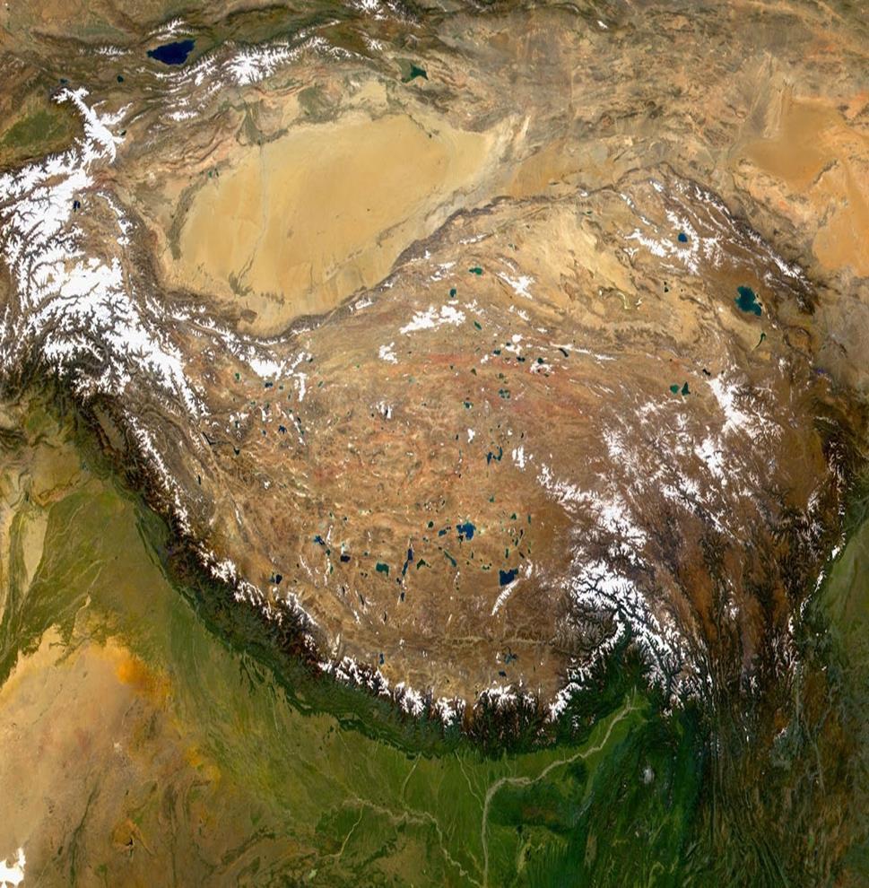
5 The Plateau of Tibet Also known as the Tibetan Plateau, this area is often called the Roof of the World. Its average elevation is more than two miles above sea level. It is a very large area, covering almost a quarter of the land in China. It is the world s largest plateau. It is a rocky land surrounded by towering mountains. The Himalayas are on the southern edge of the plateau. The tallest mountain in the world, Mount Everest, is part of this mountain range. Its peak is more than five miles high. Since the Tibetan Plateau is so high, the climate is very cold. The air is thin and dry. This region is a bitterly cold place to live. There are only about 50 days a year without frost. Snowstorms are common, even in July.
6 The Northwestern Deserts 1. The northwestern part of Outer China is known for its great deserts, including the Taklimakan and Gobi Deserts. 2. The deserts are harsh places to live and difficult for travelers to cross. 3. The climate varies from sizzling hot in the summer to below freezing in winter. 4. The only places to grow crops or raise animals such as sheep are the oases, where water can be found. 5. In ancient times, shelters made of mud were sometimes built near oases. Taklimakan Desert Gobi Desert
7

8 The Taklimakan Desert (takla-mahkahn) 1. is about 105,000 square miles. It is considered one of the most dangerous deserts in the world. In fact, its name means, Once you go in, you will not come out. 2. The desert s huge sand dunes shift and change as the wind blows the sand around. Sandstorms arise with stunning speed. 3. Legend says that two armies and 300 cities are buried 600 feet beneath the sand dunes. 4. As you might expect, the desert is too dry to have much vegetation. Bushes, weeds, and trees grow only near oases and along rivers.

9 The Gobi Desert 1. is one of the world s largest deserts, stretching over 500,000 square miles. It covers part of China and present-day Mongolia. 2. Unlike the Taklimakan Desert, the Gobi has very few sand dunes. 3. Most of the desert is stony. Its surface is made up of small pebbles and tiny bits of sand. 4. Vegetation is sparse. Plants tend to be small and widely spaced.
10 Mountains Altay Mts Why would these geographic features make sea trade more popular than overland trade? Tian Shan Mts Kunlun Shan Mts Altun Mts Of course, the invention of boats will need to come later in time. Who invented the sailboat again? Himalayas
11 Turn and Talk Geographic Features List at least two specific problems the geographic features of China created. Effect on China s Civilization Rivers Mountains Deserts 1. Provided rich soil for Chinese farmers 2. Caused many deaths by flooding 3. Used waterways for trade and transportation 1. Formed a barrier around the country making it difficult for invaders to enter 2. Making it difficult to govern effectively 3. Made it possible for China to develop a unique culture and civilization 1. Created a barrier around the country like the mountains did


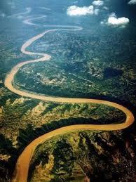
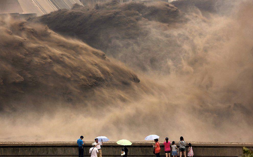
12 Huang He- Yellow River China s Sorrow


13 Loess - Yellow Silt that flows down the Huang He River into the Yellow Sea which is part of the Pacific Ocean
 Yellow Sea Pacific")
14 Shang dynasty(1 st dynasty)- settles in the Yellow River Valley (Huang He River Valley) Yellow Sea Pacific Ocean

15 Let s label together
16 Explain how the geographic features of China would make the spread of ideas and goods difficult. Include the following key words in your answer: Gobi Desert Himalayas Pacific Ocean Detour (ed)(s) Plateau of Tibet Trade routes East West Bonus Words: Circle these in your answer IF you use them: Isolated Obstacles Barrier Bypass
17 Success Criteria: Ch. 7 China Last Name 1. Identify China, the Huang He River, the Gobi Desert, and the Plateau of Tibet on any map. 2. Identify where the first civilization settled in China. Name the river valley. 3. What is the meaning of Huang He? Why is it called this? 4. Using your cardinal directions, where is China located on the continent of Asia? 5. List at least two specific problems the geographic features of China created. Vocabulary: Yellow River Huang He River Loess Yangtze River Plateau of Tibet Gobi Desert Taklimakan Desert Obstacles things that block one's way; syn. barrier Detour- avoid or bypass Isolated - - far away from; having little contact
Geography and the Early Settlement of China
 Chapter 19 Geography and the Early Settlement of China How did geograptiy affect life in ancient China? Chapter 19 Geography and the Early Settlement of China How did geograptiy affect life in ancient
AERO Standards: c c.
 AERO Standards: 4.1.5.c. Identify cause and effect relationships in history. 4.3.5.c. Apply concepts such as location, distance, direction, scale, movement and region. Northeast plains Also known as the
Terms to Know. archipelago tsunami loess
 Chapter Objectives Identify East Asia s varied landforms, water systems, and natural resources. Explain the factors that influence East Asia s diverse climates and vegetation. The Land Section 1 Objectives
Chapter 13 Geography and the Early Settlement of India. How did geography affect early settlement in India?
 Chapter 13 Geography and the Early Settlement of India How did geography affect early settlement in India? Section 13.1 - Introduction The Art Archive / Collection Antonovich / Gianni Dagli Orti This stone
Name: Date: Period: CHAPTER 19: Geography and the Early Settlement of China (pages ) Label:
 Label:") Name: Date: Period: CHAPTER 19: Geography and the Early Settlement of China (pages 183-193) Label: Plains of China (N and NE) Gobi Desert Taklimakan Desert Tibet-Qinghai Plateau Himalaya Mountains Huang
Name: Date: Period: CHAPTER 19: Geography and the Early Settlement of China (pages 183-193) Label: Plains of China (N and NE) Gobi Desert Taklimakan Desert Tibet-Qinghai Plateau Himalaya Mountains Huang
STUDY GUIDE. Physical Features. The Land. Chapter 23, Section 1. Landforms. Rivers. Natural Resources. Terms to Know DRAWING FROM EXPERIENCE
 For use with textbook pages 569 574. The Land Terms to Know subcontinent A landmass that is large and distinct but joined to a continent (page 569) alluvial plain An area of fertile soil deposited by river
Deserts. Locations of deserts WORDS
 1 WORDS certain =special cover =here: make up create = make cut off =separate little = not very much rise = go up surface =the top layer of an object trade wind = a tropical wind that blows to the equator
West Africa Desertification in West Africa
 Non-fiction: West Africa Desertification in West Africa West Africa Desertification in West Africa In Arabic, Sahel means shore, or coast. The Sahel is the place where the waves of the ocean crash onto
MONSOONS. Summer Monsoon
 MONSOONS A monsoon is a seasonal change in the direction of the prevailing, or strongest, winds of a region. Monsoons cause wet and dry seasons throughout much of the tropics. Monsoons are most often associated
SAUSD Common Core First Grade Unit of Study. Student Learning Journal. Exploring Our World. Name
 Exploring Our World Student Learning Journal Name SAUSD Common Core First Grade Unit of Study Songs of Higher Learning www.songsofhigherlearning.com Lesson 1 2 Continents and Ocean Song In this world,
STUDY GUIDE. The Land. Physical Geography of Europe. Chapter 11, Section 1. Terms to Know DRAWING FROM EXPERIENCE ORGANIZING YOUR THOUGHTS
 For use with textbook pages 271 276. The Land Terms to Know dikes Large banks of earth and stone that hold back water (page 272) polder Drained area of land (page 272) glaciation The process in which glaciers
What Country is Upstream? Conflicts that can occur because of relative position on a river
 What Country is Upstream? Conflicts that can occur because of relative position on a river The source of a river is the place where it starts - usually in hills or mountains. People who live near a river
Station 1: Ocean Currents Use the ocean currents map copied from page 4 of the ESRT and the passage to answer the questions that follow.
 Station 1: Ocean Currents Use the ocean currents map copied from page 4 of the ESRT and the passage to answer the questions that follow. The Map: Questions: 1. Name the cool current off the West coast
Mountains and Oceans Mount Everest
 Mountains and Oceans Mount Everest Illustration by Lynn M. Hanousek Mount Everest is the highest mountain in the world. It sits in the Himalayan mountain range. It is located north of India on the border
Module 2 Narration What is a watershed?
 Module 2 Narration What is a watershed? Timing Key Narrative Snapshots a) 00:10 Every living thing relies on water to exist. But where does our water come from? The most natural place to look is upstream
America s First People
 Name Block America s First People As you read about each of the American Indian groups, answer the questions and color the map according to the directions for each group. Alaska s Inuits Map Directions:
The Land Where Continents Collided. Physical Geography and Climate of South Asia
 The Land Where Continents Collided Physical Geography and Climate of South Asia South Asia Countries include: 1. Pakistan 2. India 3. Nepal 4. Bhutan 1 2 3 5 4 5. Bangladesh 6. Sri Lanka 7. Maldives 7
Section 2- Migration
 Section 2- Migration Today, most scientists agree that the first people in North America came from Asia. This migration is estimated to have taken place during the last ice age, at least 12,500 years ago.
Physical Features, Where People Live, & How They Trade
 Physical Features, Where People Live, & How They Trade 5 large freshwater lakes in central North America HOMES (Huron, Ontario, Michigan, Erie, Superior) Serve as the industrial heartland of the continent
Maggie s. Activity Pack! The Nomad s Home. Daybreak on the Steppe. The Land of Nomads
 Maggie s Activity Pack! Name Date The Nomad s Home Daybreak on the Steppe The hot sun rises on the vast, dry grasslands of Central Asia. It lights up the bright orange-colored door of a Mongolian herder
INDIA and surrounding areas
 INDIA and surrounding areas A Day in the Spice Many of today s most used spices are na3ve to the Indian region of the world. Christopher Columbus crossed the Atlan3c Ocean in hopes of gaining that tasty
Desert Racing. Desert Racing
 Desert Racing Desert Racing When South African runner Ryan Sandes showed up for his first race in the 4 Deserts series in 2008, he was not expected to win. The then 27 year old had only been running for
* Appalachian Mountains -the mountain range in the Eastern U.S. which terminates in north-central Alabama
 MR. SAND TEACHER'S MANUAL INTRODUCTION: Although Mr. Sand is a cartoon presentation that is attractive to children (of all ages), the material is technically accurate and quite significant to our understanding
Canada s Natural Systems. Canadian Geography 1202
 Canada s Natural Systems Canadian Geography 1202 Canada s Natural Systems Natural System: A system found in nature Here are the four natural systems that we will explore in the next few weeks 1. Canada
Maggie s. Activity Pack! The Nomad s Home. Daybreak on the Steppe. The Land of Nomads
 Maggie s Activity Pack! Name Date The Nomad s Home Daybreak on the Steppe The hot sun rises on the grasslands of Central Asia. It lights up the bright orange door of a herder s home. This home is called
Notepack 41. Aim: What factors determine the climate of a certain area? Do Now: What is the difference between weather and climate?
 Notepack 41 Aim: What factors determine the climate of a certain area? Do Now: What is the difference between weather and climate? WEATHER VS. CLIMATE Weather atmospheric conditions at a certain location
Performance Task: World Mountains
 Performance Task: World s Teacher Directions: In this activity, students will demonstrate their understanding of world mountains using both a map and a written assignment. Ask students to annotate the
Sprinting on Springs. Why the world s tallest mountain has become more dangerous to climb than ever. life Animal Highways.
 FEBRUARY 2013 VOL. 24 NO. 5 ISSN 1010-144X WATCH A VIDEO ON LANDFORMS life Animal Highways physical Sprinting on Springs earth EVEREST S DEATH ZONE Why the world s tallest mountain has become more dangerous
3 Global Winds and Local Winds
 CHAPTER 15 3 Global Winds and Local Winds SECTION The Atmosphere BEFORE YOU READ After you read this section, you should be able to answer these questions: What causes wind? What is the Coriolis effect?
Reading and Vocabulary Study Guide
 Reading and Vocabulary Study Guide Boston, Massachusetts Upper Saddle River, New Jersey The map on page 20 is based on a map by DK Cartography. Copyright by Pearson Education, Inc., publishing as Pearson
The Ahamacave or Mohave The Mohave continue to live in their river valley homelands The Mohave eat many different types of food dammed
 The Ahamacave or Mohave The information below is taken from The Ahamacave (commonly pronounced as Mohave) Traveling Suitcase exhibit for Museum Education Outreach, Grade Levels 3-4, 5-6 Teacher Manual,
Hoover Dam. Hoover Dam A Reading A Z Level M Leveled Book Word Count: 527 LEVELED BOOK M
 A Reading A Z Level M Leveled Book Word Count: 527 LEVELED BOOK M Connections Writing Write a paragraph about the importance of. Include a main idea and at least three supporting details from this book
Biyani's Think Tank. Concept based notes. Geography of Asia BA-III. Shweta Modi Deptt. of Arts Biyani Girls College, Jaipur
 Biyani's Think Tank Concept based notes Geography of Asia BA-III Shweta Modi Deptt. of Arts Biyani Girls College, Jaipur 2 Published by : Think Tanks Biyani Group of Colleges Concept & Copyright : Biyani
GRADE 1-3: SOCIAL STUDIES EARLY FIRST NATIONS AND INUIT REGIONS FLIPBOOK
 GRADE 1-3: SOCIAL STUDIES EARLY FIRST NATIONS AND INUIT REGIONS FLIPBOOK Purpose: Students will learn about what life was like for different First Nations and Inuit people prior to European contact: where
2. The phrases on the left in the following box occur in the text. Match each of them with a phrase on the right. (i) an endless stretch of sand
 an endless stretch of sand") A desert is generally without water and vegetation. A green patch with fresh water and green trees in the middle of a vast desert is a beautiful sight. A desert may be too hot or too cold. THOSE of us
A desert is generally without water and vegetation. A green patch with fresh water and green trees in the middle of a vast desert is a beautiful sight. A desert may be too hot or too cold. THOSE of us
3 Global Winds and Local Winds
 CHAPTER 6 3 Global Winds and Local Winds SECTION The Atmosphere BEFORE YOU READ After you read this section, you should be able to answer these questions: What causes wind? What is the Coriolis effect?
Nepal Maps Detailed Nepal Travel Maps 2019/2020 tibet trekking map kathmandu lhasa kailash nepal sikkim bhutan indiatrekking.
 DOWNLOAD OR READ : TIBET TREKKING MAP KATHMANDU LHASA KAILASH 1 1 500 000 NEPAL SIKKIM BHUTAN INDIATREKKING THE ANNAPURNA CIRCUIT AND ANNAPURNA SANCTUARY IN THE NEPAL HIMALAYA PDF EBOOK EPUB MOBI Page
Chapter 10, Part 1. Scales of Motion. Examples of Wind at Different Scales. Small Scale Winds
 Chapter 10, Part 1 Small Scale Winds Scales of Motion Wirls or eddies exist at all length scales in the atmosphere. Microscale (2m) Mesoscale (20km) Synoptic scale (2000km) Examples of Wind at Different
Physical Geography. Physical Geography III of the United States and Canada. Formation of Great Lakes. Climates of North America. Definitions 2/21/2013
 Physical Geography III of the United States and Canada Ancient Glacial Lakes As the Ice Age ended, areas of North America beyond the terminal moraine were flooded with melt water Prof Anthony Grande AFG
Coastal management has lagged behind the growth in population leading to problems with pollution
 Fifty percent of the population of the industrialized world lives within 100 km of a coast. Coastal management has lagged behind the growth in population leading to problems with pollution and natural
Deserts and Desert Environments
 Deserts and Desert Environments Introduction Aeolian geomorphology is the study of the effect of wind on Earth surface processes and landforms Wind: the movement of air from one place to another, specifically
History of the Tallebudgera Beach Outdoor Education School
 DIARY ANSWERS History of the Tallebudgera Beach Outdoor Education School P4 Access the Beach School website to complete this page: www.thebeachschool.eq.edu.au About Our School > History of our School
CHAPTER 2. Native Americans and Their Land
 CHAPTER 2 Native Americans and Their Land 2.1 INTRODUCTION Native Americans are believed to be the first people to live in North America They first migrated into the Americas from the continent of Asia
News English.com Ready-to-use ESL / EFL Lessons
 www.breaking News English.com Ready-to-use ESL / EFL Lessons Survey shows Mt. Everest has shrunk URL: http://www.breakingnewsenglish.com/0510/051010-everest-e.html Today s contents The Article 2 Warm-ups
Giant Traveling Map Lesson
 Giant Traveling Map Lesson TITLE / AUTHOR: Colorado as Headwaters Exploring Our Rivers / Sarah R. Johnson COLORADO ACADEMIC STANDARDS / SUITABLE DISCIPLINES: Social Studies, Geography: Third Grade Standard
Natural Regions of the World
 Natural Regions of the World Revision for Competitive Exams 10x10learning.com 1 Concept of Natural Regions provides a framework for understanding the diversity of physical and biological environment Taiga
TOM NEWBY SCHOOL EXAMINATION. Answer in full sentences. Write all answers on the question paper QUESTION 1: (6)
") 1 TOM NEWBY SCHOOL EXAMINATION Subject GEOGRAPHY Examiner MR J MAREDI Date 15 JUNE 2017 Total marks 50 Session 1 Duration 1 HOUR Grade 5 Moderator MISS M ALBERTYN Special instructions/ Equipment Answer
1 TOM NEWBY SCHOOL EXAMINATION Subject GEOGRAPHY Examiner MR J MAREDI Date 15 JUNE 2017 Total marks 50 Session 1 Duration 1 HOUR Grade 5 Moderator MISS M ALBERTYN Special instructions/ Equipment Answer
Draw a picture of a water source. Don t forget to include yourself in the picture!
 Name Date Draw a picture of a water source. Don t forget to include yourself in the picture! My water source is Students describe the characteristics of a water source: stream, river, lake, pond, ocean,
Global Winds and Local Winds
 Global Winds and Local Winds National Science Education Standards ES 1j What is the Coriolis effect? What are the major global wind systems on Earth? What Causes Wind? Wind is moving air caused by differences
Last year, 73-year-old Tamae Watanabe
 Mount Everest s Death Zone Climate change and crowds of climbers are making the world s tallest mountain more dangerous than ever Mara Grunbaum Last year, 73-year-old Tamae Watanabe of Japan became the
MT - GEOGRAPHY - (73) - SEMI PRELIM - II : PAPER - 6
 - SEMI PRELIM - II : PAPER - 6") 208 00 MT MT - GEOGRAPHY - (7) - SEMI PRELIM - II : PAPER - 6 Time : 2 Hours (Model Answer Paper) Max. Marks : 0 A.. Fill in the blank choosing the correct alternative : (a) The Barren Island is the only
208 00 MT MT - GEOGRAPHY - (7) - SEMI PRELIM - II : PAPER - 6 Time : 2 Hours (Model Answer Paper) Max. Marks : 0 A.. Fill in the blank choosing the correct alternative : (a) The Barren Island is the only
Chapter- 9. Multiple Choice Questions
 Chapter- 9 Multiple Choice Questions 1. The low-latitude climates: a. are located along the equator b. are located between the tropics of cancer and capricorn c. do not include the ITCZ d. are restricted
Thunderstorms explained
 1. Storms Information Sheet What is a storm? A storm is bad weather with strong winds, rain or snow, and often thunder and lightning too. There are many different types of storm. Thunderstorms explained
Welcome to GCSE Geography. Where will it take us today?
 Welcome to GCSE Geography Where will it take us today? Topic 1.1: global hazards 1.1a: How can weather be hazardous? iii) El Nino, La Nina and their impact on drought 12/10/2018 Think back.. This a affects
Wind in the Atmosphere
 Lesson 2 Wind in the Atmosphere ESSENTIAL QUESTION What is wind? By the end of this lesson, you should be able to explain how energy provided by the sun causes atmospheric movement, called wind. p 6.ESS2.2,
Montessori for Everyone 2013 Types of Coastlines
 Coast The coast is the part of the land that borders the sea. It is subject to constant change, as the result of the waves and deposits carried by water onto the land. Coastline The coastline is where
National Weather Service
 National Weather Service The North American Monsoon Until the late 1970s, there was serious debate about whether a monsoon truly existed in North America. However, considerable research, which culminated
3 Global Winds and Local Winds
 CHAPTER 1 3 Global Winds and Local Winds SECTION The Atmosphere BEFORE YOU READ After you read this section, you should be able to answer these questions: What causes wind? What is the Coriolis effect?
CD Compilation Copyright by emilitary Manuals
 CHAPTER 1 THE ENVIRONMENT AND ITS EFFECTS ON PERSONNEL AND EQUIPMENT This chapter describes the desert environment and how it affects personnel and equipment. CONTENTS Page Section I The Environment..................
The geography of Mapungubwe
 The geography of Mapungubwe Grade 6, Term 1 Social Science: History Lesson Topic: The geography of Mapungubwe Lesson 2 of 8 CAPS reference: page 42 Total time: 1 hour Aims Engage higher order thinking
Vocabulary: Headwaters, watershed, tributaries, estuary, replica, point source pollution, nonpoint source pollution, amd river miles.
 From Source To Sea: Lesson Plan Concepts: 1. Understanding the path the Hudson River takes from the headwaters in the Adirondacks to the New York Harbor 2. Identifying the Hudson River watershed area,
A desert is a place where very little rain falls. The air is dry. The ground is dry.
 1A A desert is a place where very little rain falls. The air is dry. The ground is dry. It is a land of rocks and sand. The sun beats down. The days are hot. At night, it can be very cold. A desert is
8/29/20098 SAHRA - Watershed Visualization
 Module 3 Narration Southwestern Water Cycle 001.wav 26 sec 002.wav 10 sec 003 wav 17 sec Water on Earth is constantly on the move. Water continually circulates between the surface of Earth and the atmosphere
Chapter 15. The Work of Wind and Deserts
 Chapter 15 The Work of Wind and Deserts Introduction What is desertification? Desertification is the expansion of deserts into formerly productive lands. These expansions destroy croplands and rangelands.
ì<(sk$m)=becdcd< +^-Ä-U-Ä-U
=becdcd< +^-Ä-U-Ä-U") Reader Genre Build Background Access Content Extend Language Expository Nonfiction Society Adapting Culture Geography Captions Definitions Map Fact Box Building and Road Words Scott Foresman Reading Street
Reader Genre Build Background Access Content Extend Language Expository Nonfiction Society Adapting Culture Geography Captions Definitions Map Fact Box Building and Road Words Scott Foresman Reading Street
Reading 6.1 Competition Between Populations
 Reading 6.1 Competition Between Populations In the ecosystem models you used in class you discovered that population sizes can fluctuate. One type of fluctuation that can appear is repeating cycles of
Water Habitat Model. Outcome: Materials: Teacher Instructions: : Identify the components of an animal habitat..
 Water Habitat Model Outcome: 4-1-03: Identify the components of an animal habitat.. Materials: Shoe boxes (1 per student) Art supplies: Glue and/or tape Paint and brushes for the background Plasticine/clay
??? 45km) : 426A. D China Academic Journal Electronic Publishing House. All rights reserved.
 : 426A. D China Academic Journal Electronic Publishing House. All rights reserved.") 24 2 2 0 0 4 3 QUATERNARY SCIENCES Vol. 24, No. 2 March, 2004 1001-7410(2004) 02-184 - 07 (, 210008) 2201368A. D. 859, ; 289,, (581907A. D. ),,,25 % (13681911A. D. ),, P642. 131, S151 A?? ( )??,,,,,,,
24 2 2 0 0 4 3 QUATERNARY SCIENCES Vol. 24, No. 2 March, 2004 1001-7410(2004) 02-184 - 07 (, 210008) 2201368A. D. 859, ; 289,, (581907A. D. ),,,25 % (13681911A. D. ),, P642. 131, S151 A?? ( )??,,,,,,,
NAADAM CLASSIC TOUR JULY 10-21, 2017
 NAADAM CLASSIC TOUR JULY 10-21, 2017 Highlights Naadam opening ceremony, wrestling, horse racing and archery contest Visit to South Gobi, Bayan Zag cliff, Yol valley Visit to Karakorum, Erdene Zuu monastery
Podcast 58 - Perth, Western Australia - A Life in the Sun
 Podcast 58 - Perth, Western Australia - A Life in the Sun by Rob McCormack - Thursday, April 23, 2015 http://slowenglish.info/?p=1609 Learn English while learning about daily life in Australia, with Rob
2618 % ( Ti2 betan Plateau), ] (1939,1953), L czy (1899) ( G ) ; 4 E2mail :
![2618 % ( Ti2 betan Plateau), ] (1939,1953), L czy (1899) ( G ) ; 4 E2mail :](/thumbs/91/107083486.jpg "2618 % ( Ti2 betan Plateau), ] (1939,1953), L czy (1899) ( G ) ; 4 E2mail :") 21 1 2002 1 Vol. 21, No. 1 GEO GRAPHICAL RESEARCH Jan., 2002 : 100020585 (2002) 0120001210,, (, 100101) :,,,, :,, 31, 2 945km ;, -, 13, 1 532 km ; 26 00 12 N 39 46 50 N, 73 18 52 E 104 46 59 E, 257214
21 1 2002 1 Vol. 21, No. 1 GEO GRAPHICAL RESEARCH Jan., 2002 : 100020585 (2002) 0120001210,, (, 100101) :,,,, :,, 31, 2 945km ;, -, 13, 1 532 km ; 26 00 12 N 39 46 50 N, 73 18 52 E 104 46 59 E, 257214
Yes, Ma am! By Cheryl Graham
 Yes Ma am By Cheryl Graham Are these Coastal Natives? Are these Coastal Natives? How did their environment support them? Provided salmon and shellfish. How did their environment constrain them? Limited
Name: Date: Day/Period: CGC1P1: Interactions in the Physical Environment. Factors that Affect Climate
 Name: Date: Day/Period: CGC1P1: Interactions in the Physical Environment PART A: Weather and Climate Factors that Affect Climate 1. The words weather and climate are often incorrectly used interchangeably.
WHAT ARE ECOSYSTEMS? Dr. V. N. Nayak Professor of Marine Biology (Retd)
") WHAT ARE ECOSYSTEMS? Dr. V. N. Nayak Professor of Marine Biology (Retd) An ECOSYSTEM is an interacting system of plant, animals, and humans and the surrounding environment. An ecosystem contains living
WHAT ARE ECOSYSTEMS? Dr. V. N. Nayak Professor of Marine Biology (Retd) An ECOSYSTEM is an interacting system of plant, animals, and humans and the surrounding environment. An ecosystem contains living
Ocean Motion Notes. Chapter 13 & 14
 Ocean Motion Notes Chapter 13 & 14 What is a Wave? Wave: movement of energy through a body of water How are Waves Caused? Caused mostly by wind Wind blowing on the water transmits energy to the water Size
Air Masses and Fronts
 Air Masses and Fronts A huge body of air that has similar temperature, humidity, and air pressure at any given height is called an air mass. A single air mass may spread over millions of square kilometers
Contents. Chapter 1 Introduction Chapter 2 The Eiger Chapter 3 Mount Everest, Chapter 4 Mount Hood,
 Contents Chapter 1 Introduction.... 4 Chapter 2 The Eiger... 12 Chapter 3 Mount Everest, 1996... 18 Chapter 4 Mount Hood, 1986... 32 Chapter 5 Siula Grande, 1985... 48 Chapter 6 Denali, 1992.... 56 Chapter
Teacher Edition. AlphaWorld. Deserts. Written by Keith Pigdon
 Teacher Edition AlphaWorld Deserts Written by Keith Pigdon Published edition Eleanor Curtain Publishing 2003 First published 2003 Apart from any fair dealing for the purposes of study, research, criticism
The Great Wall of China
 Level 1-10 The Great Wall of China Rob Waring Summary This book is about who built the Great Wall of China and why it was built Contents Before Reading Think Ahead 2 Vocabulary 3 During Reading Comprehension
This is America: The Potomac River Flows Through Cities, History
 This is America: The Potomac River Flows Through Cities, History Today we tell about the Potomac River. The Potomac is one of America s most historic waterways. It flows more than 600 kilometers, from
Work Sample. Terry INTRODUCTION
 INTRODUCTION As an environmental consultant, I will be conducting an investigation into the effectiveness of the coastal management strategies currently being undertaken at XXX beach. Here I will be looking
CLIMB EVEREST WITH RICH!
 CLIMB EVEREST WITH RICH! CLIMB EVEREST WITH RICH! raise money with our sponsorship form or online! choose richardparks737challenge on just giving! Raising funds in aid of: In December 2010 former Wales
The Official Mascots of the Beijing 2008 Olympic Games - The Officia...
 1 of 5 2008/07/21 02:35 AM The Official Website of the Beijing 2008 Olympic Games The Official Mascots of the Beijing 2008 Olympic Games Like the Five Olympic Rings from which they draw their color and
Bouddi Coastal Walk. 5 hrs. Hard track 8.1 km One way. 364m
 Bouddi Coastal Walk 5 hrs Hard track 8.1 km One way 4 364m This is one of the longer walks in the Bouddi National Park and it is rich in scenery. The walk follows the coastline with many side trips to
a bike at age 100. She loved her birthdays. Her family and friends came to each 1. How long did Jean Calment live? 2. Where did she live?
 fence birthdays bored enjoyed traveled dreaming fence birth days bored en joyed trav eled dream ing THE OLDEST PERSON How long can a person live? Jean Calment lived to be 122 years old. She lived in France.
Going Up a Mountain By ReadWorks
 Going Up a Mountain Going Up a Mountain By ReadWorks Mount Everest is the tallest mountain in the world. It is located in the country of Nepal. It is 8,848 meters tall. This means it is just over five
and the Link between Oceans, Atmosphere, and Weather
 Geography Worksheet Instructions Using a map, atlas, or any other materials your teacher suggests, label the following on the blank map provided. 1. Label East, West, North, and South. 2. Label the following
Climate and Climate Change
 Climate and Climate Change Chapter Test A Multiple Choice Write the letter of the correct answer on the line at the left. 1. Climates are classified according to two major factors: a. elevation and precipitation.
Racing and Breeding in Mainland Part I
 LOGO Racing and Breeding in Mainland Part I Speaker: Prof. Guocai Han Vice Chairman, Chinese Horse Industry Association Horse Racing in the Mainland of China Guocai Han Vice Chairman, China Horse Industry
Wind in the Atmosphere
 Lesson 1 Wind in the Atmosphere Essential Question What is wind? By the end of this lesson, you should be able to explain how energy provided by the sun causes atmospheric movement, called wind. 8.10A
SPOTLIGHT ON BOISE WELCOME TO BOISE, IDAHO. Contents
 WELCOME TO BOISE, IDAHO Boise is the capital and most populous city of the U.S. state of Idaho, as well as the county seat of Ada County. Located on the Boise River in southwestern Idaho, the population
Objective To guide students as they look up and compare numerical data, including geographical measurements. Family Letters. Assessment Management
 Comparing Data Objective To guide students as they look up and compare numerical data, including geographical measurements. www.everydaymathonline.com epresentations etoolkit Algorithms Practice EM Facts
UNIT 1: WATER SYSTEMS ON EARTH CHAPTER 3
 UNIT 1: WATER SYSTEMS ON EARTH CHAPTER 3 HEAT CAPACITY HEAT CAPACITY (SPECIFIC HEAT CAPACITY) IS THE AMOUNT OF HEAT THAT A SUBSTANCE CAN HOLD WATER HAS A HIGH HEAT CAPACITY IT CAN TAKE IN A LARGE AMOUNT
Global Weather Patterns
 Global Weather Patterns AZ State Standards Concept 2: Energy in the Earth System (Both Internal and External) Understand the relationships between the Earth s land masses, oceans, and atmosphere. PO 2.
Grade 8 Science: Unit 1 Water Systems Chapter 3
 Heat Capacity Grade 8 Science: Unit 1 Water Systems Chapter 3 Heat capacity ( ) is the amount of heat that a substance can hold. has a high heat capacity it can take in a large amount of heat before its
GEOS 201 Lab 13 Climate of Change InTeGrate Module Case studies 2.2 & 3.1
 Discerning Patterns: Does the North Atlantic oscillate? Climate variability, or short term climate change, can wreak havoc around the world. Dramatic year to year shifts in weather can have unanticipated
OCEANS. Main Ideas. Lesson 2: Ocean Currents Ocean Currents help distribute heat around Earth.
 Oceans Chapter 10 OCEANS Main Ideas Lesson 2: Ocean Currents Ocean Currents help distribute heat around Earth. Lesson 3: The Ocean Shore The shore is shaped by the movement of water and sand. OCEANS SO
Where Animals and Plants Are Found
 About Animals and Plants What I Need to Know Many different animals and plants live on Earth. The animals and plants live in different places and make up parts of different ecosystems. In an ecosystem,
Scales of Atmospheric Motion
 Lecture 12 Local Wind Systems Scales of Atmospheric Motion Small turbulent eddies (swirls) A synoptic eddy 1 Coriolis Effect The larger the scale, the longer the life time. Wind shear and turbulent eddy
The context of the region
 Chapter-6 The context of the region The major part of the Indian desert falls within the state of Rajasthan, where it is known as the Thar Desert. Parts of Kutch in Gujarat state also have desert-like