AERO Standards: c c.
|
|
|
- Logan Hamilton
- 5 years ago
- Views:
Transcription


1 AERO Standards: c. Identify cause and effect relationships in history c. Apply concepts such as location, distance, direction, scale, movement and region.


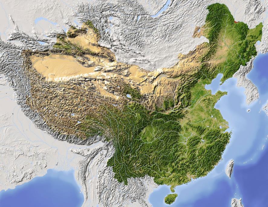
2 Northeast plains Also known as the Manchurian Plain, the Northeast Plain is North of the Korean peninsula. The Northeast Plain has extremely cold and dry winters. This land feature also experiences very strong seasonal winds due to its nearness to the Gobi Desert and because plains often can experience strong winds. The majority of Northeastern residents live closer to the China-Korea divide because any further North has a nearly unbearably cold climate. Changbai Mountain is a land feature that divides China and Korea. The Changbai mountains are said to be the mythical birthplace of the Manchu clan. Legend says that the birth of the first Manchu person came from a women who ate fruit then became pregnant plains


3 Eastern plains In the Eastern Plains of China, lowlands cover most of the land. The only mountains in the plains are Taishan and Dabie mountains. The Eastern Plains also have two of China s major rivers crossing through it, the Yangtze river in the South and the Huang He river in the North. Eastern China is also where most of China s 1.3 billion people live. In the North of this land feature is China s capital, Beijing. In the South this region has most of China s industry and farmlands. Before paper came to Europe, it took about 250 sheep skins to make a bible That s baaaa-d. industry: a large factory used to make things quickly develop: to make something new plains


4 southern hills China s Southern Hills experiences much higher rain fall than the rest of China. Summer monsoons often bring 250+ inches of rain in just a few months. This amount of rainfall makes southern China tropical. The Southern Hills are also crossed by one of China major rivers, the Xi river. In addition to the rainfall, Southern China also has low mountain ranges which have acted as a barrier from other countries in China s past. Before paper came to Europe, it took about 250 sheep skins to make a bible That s baaaa-d. Summer monsoons: a time of year when it rains a lot. mountain range: many mountains that are connected hills


5 Tibetan Highlands In Southwest China is located the Tibetan Plateau which is the largest and highest plateau in the world. This plateau has an average height of 4,000 meters above sea level. It has been nicknamed the Roof of the World, because of this plateau s extreme average height. This land feature also has the world s tallest mountains, the Himalayas. Eleven of the 17 tallest mountain peaks can be found in this mountain range, including Mt. Everest which has a height of 8,848 meters. This land feature has served as a physical barrier from enemies and other countries for China. The Tibetan Plateau covers over 2.5 million square kilometers, or about 1/5 of China s total land. plateau: a high flat piece of land The Taklamakan desert is the largest desert in China, and it remains virtually unexplored even today. plateau


6 Xinjiang - Mongolia In the far west of China, between the Kunlun and Tianshan mountain ranges, is the huge Tarim Basin. This basin is the largest in China and it measures 1,500 kilometers from east to west. The average elevation for this basin is about 1,000 meters. Within this basin is the Taklamakam Desert which is one of the few places in China that is unpopulated. North of the Tianshan mountains is Xinjiang s second great basin which has another desert, the Gurbantünggüt Desert. Further east is the Gobi Desert. This desert occupies the southern part of Mongolia, as well as a majority of the north central part of China. Although this land feature is large, it has to lowest population of people among the other four geographical regions. basin: elevation: height of the land The Taklamakan desert is the largest desert in China, and it remains virtually unexplored even today. desert


7 Mongolia Mongolia has three major physical features: the steppes, the highlands, and the Gobi desert. The steppes are where most people live in Mongolia. The steppes are rolling grasslands which are treeless and desert-like. The steppes also provide a good area for Mongolia s animals to roam. The second physical feature, the highlands, are located in the northwest part of Mongolia. The highlands include two mountain ranges, and most of Mongolia s rivers start here. These rivers provide water for the people and animals living in the steppes. The third physical feature is the Gobi desert. The Gobi desert has very few trees and it is the biggest desert in Asia, and the 5 th biggest desert in the world. Highlands Steppes steppes: a plain with nearly no trees develop: to make something new Gobi desert steppes
Terms to Know. archipelago tsunami loess
 Chapter Objectives Identify East Asia s varied landforms, water systems, and natural resources. Explain the factors that influence East Asia s diverse climates and vegetation. The Land Section 1 Objectives
Success Criteria: Ch. 7 China
 Log in to Geography of China ppt Success Criteria: Ch. 7 China Last Name 1. Identify China, the Huang He River, the Gobi Desert, and the Plateau of Tibet on any map. 2. Identify where the first civilization
STUDY GUIDE. Physical Features. The Land. Chapter 23, Section 1. Landforms. Rivers. Natural Resources. Terms to Know DRAWING FROM EXPERIENCE
 For use with textbook pages 569 574. The Land Terms to Know subcontinent A landmass that is large and distinct but joined to a continent (page 569) alluvial plain An area of fertile soil deposited by river
Geography and the Early Settlement of China
 Chapter 19 Geography and the Early Settlement of China How did geograptiy affect life in ancient China? Chapter 19 Geography and the Early Settlement of China How did geograptiy affect life in ancient
The Land Where Continents Collided. Physical Geography and Climate of South Asia
 The Land Where Continents Collided Physical Geography and Climate of South Asia South Asia Countries include: 1. Pakistan 2. India 3. Nepal 4. Bhutan 1 2 3 5 4 5. Bangladesh 6. Sri Lanka 7. Maldives 7
Natural Regions of the World
 Natural Regions of the World Revision for Competitive Exams 10x10learning.com 1 Concept of Natural Regions provides a framework for understanding the diversity of physical and biological environment Taiga
MONSOONS. Summer Monsoon
 MONSOONS A monsoon is a seasonal change in the direction of the prevailing, or strongest, winds of a region. Monsoons cause wet and dry seasons throughout much of the tropics. Monsoons are most often associated
Chapter 13 Geography and the Early Settlement of India. How did geography affect early settlement in India?
 Chapter 13 Geography and the Early Settlement of India How did geography affect early settlement in India? Section 13.1 - Introduction The Art Archive / Collection Antonovich / Gianni Dagli Orti This stone
Chapter- 9. Multiple Choice Questions
 Chapter- 9 Multiple Choice Questions 1. The low-latitude climates: a. are located along the equator b. are located between the tropics of cancer and capricorn c. do not include the ITCZ d. are restricted
SAUSD Common Core First Grade Unit of Study. Student Learning Journal. Exploring Our World. Name
 Exploring Our World Student Learning Journal Name SAUSD Common Core First Grade Unit of Study Songs of Higher Learning www.songsofhigherlearning.com Lesson 1 2 Continents and Ocean Song In this world,
MT - GEOGRAPHY - (73) - SEMI PRELIM - II : PAPER - 6
 - SEMI PRELIM - II : PAPER - 6") 208 00 MT MT - GEOGRAPHY - (7) - SEMI PRELIM - II : PAPER - 6 Time : 2 Hours (Model Answer Paper) Max. Marks : 0 A.. Fill in the blank choosing the correct alternative : (a) The Barren Island is the only
208 00 MT MT - GEOGRAPHY - (7) - SEMI PRELIM - II : PAPER - 6 Time : 2 Hours (Model Answer Paper) Max. Marks : 0 A.. Fill in the blank choosing the correct alternative : (a) The Barren Island is the only
Objective To guide students as they look up and compare numerical data, including geographical measurements. Family Letters. Assessment Management
 Comparing Data Objective To guide students as they look up and compare numerical data, including geographical measurements. www.everydaymathonline.com epresentations etoolkit Algorithms Practice EM Facts
Biyani's Think Tank. Concept based notes. Geography of Asia BA-III. Shweta Modi Deptt. of Arts Biyani Girls College, Jaipur
 Biyani's Think Tank Concept based notes Geography of Asia BA-III Shweta Modi Deptt. of Arts Biyani Girls College, Jaipur 2 Published by : Think Tanks Biyani Group of Colleges Concept & Copyright : Biyani
STUDY GUIDE. The Land. Physical Geography of Europe. Chapter 11, Section 1. Terms to Know DRAWING FROM EXPERIENCE ORGANIZING YOUR THOUGHTS
 For use with textbook pages 271 276. The Land Terms to Know dikes Large banks of earth and stone that hold back water (page 272) polder Drained area of land (page 272) glaciation The process in which glaciers
Maggie s. Activity Pack! The Nomad s Home. Daybreak on the Steppe. The Land of Nomads
 Maggie s Activity Pack! Name Date The Nomad s Home Daybreak on the Steppe The hot sun rises on the grasslands of Central Asia. It lights up the bright orange door of a herder s home. This home is called
Maggie s. Activity Pack! The Nomad s Home. Daybreak on the Steppe. The Land of Nomads
 Maggie s Activity Pack! Name Date The Nomad s Home Daybreak on the Steppe The hot sun rises on the vast, dry grasslands of Central Asia. It lights up the bright orange-colored door of a Mongolian herder
Deserts. Locations of deserts WORDS
 1 WORDS certain =special cover =here: make up create = make cut off =separate little = not very much rise = go up surface =the top layer of an object trade wind = a tropical wind that blows to the equator
Rice Yield And Dangue Haemorrhagic Fever(DHF) Condition depend upon Climate Data
 Condition depend upon Climate Data") Rice Yield And Dangue Haemorrhagic Fever(DHF) Condition depend upon Climate Data Dr Lai Lai Aung, Assistant Director( Met Service) Dr Khaing Khaing Soe Assistant Director(Public Health) Dr Thin Nwe htwe
Rice Yield And Dangue Haemorrhagic Fever(DHF) Condition depend upon Climate Data Dr Lai Lai Aung, Assistant Director( Met Service) Dr Khaing Khaing Soe Assistant Director(Public Health) Dr Thin Nwe htwe
Desert Racing. Desert Racing
 Desert Racing Desert Racing When South African runner Ryan Sandes showed up for his first race in the 4 Deserts series in 2008, he was not expected to win. The then 27 year old had only been running for
THE NATIVE AMERICANS
 THE NATIVE AMERICANS Native American Diversity By the year 1500, Native Americans had divided into hundreds of cultural groups who perhaps spoke up to 2,000 different languages. Each group adapted to its
Which Countries Received the Most Medals per Population at the 2008 Summer Olympics? By W. W. Munroe August 2008
 1 Which Countries Received the Most Medals per Population at the 2008 Summer Olympics? By W. W. Munroe August 2008 The USA, China, and Russia were the big winners at the 2008 Summer Olympics in Beijing,
Monsoon. Arabic word mausim means season. Loose definition: a wind/precipitation pattern that shifts seasonally
 Monsoon Arabic word mausim means season Loose definition: a wind/precipitation pattern that shifts seasonally Classical criteria (Ramage 1971) Prevailing wind shifts 120 o between Jan & July Average frequency
Comparing U.S. Elevation to the Population Density. Each block/lego equals 500 feet in elevation above sea level.
 Name Date Comparing U.S. Elevation to the Population Density In this lesson, you will make a double-bar graph which will compare U.S. population density to the elevation of physical regions of the United
What Country is Upstream? Conflicts that can occur because of relative position on a river
 What Country is Upstream? Conflicts that can occur because of relative position on a river The source of a river is the place where it starts - usually in hills or mountains. People who live near a river
Reading and Vocabulary Study Guide
 Reading and Vocabulary Study Guide Boston, Massachusetts Upper Saddle River, New Jersey The map on page 20 is based on a map by DK Cartography. Copyright by Pearson Education, Inc., publishing as Pearson
Continental Drift Theory
 Chapter 24: Physical Geography of South Asia: The Land Where Continents Collided South Asia India, Pakistan, Nepal, Sri Lanka & Bangladesh South Asia s major landforms, including the massive Himalayan
Final Report August 2005
 2.0 REGIONAL STUDY AREA 2.1 Regional Setting 2.1.1 Topography The Los Angeles Region is located within the western portion of the Transverse Ranges Geomorphic Province. The San Andreas transform fault
Basic Impetus Chinese Army Lists
 Basic Impetus Chinese Army Lists Chinese history can be seen as a succession of barbarian peoples held at bay by a powerful Chinese dynasty which would eventually fail. The resulting invading barbarians
Amur Leopard - Diet. Learn more online conservewildcats.org
 Amur Leopard - Diet Prey: Amur leopards hunt an indiscriminate variety of animals including roe deer, sika deer, badgers and hares. Unlike tigers, if hungry leopards will happily seek out very small prey,
Dr. Xu Yong Deputy Director General of Economic and Technological Cooperation Department of Jilin Province,P.R.C.
 Dr. Xu Yong Deputy Director General of Economic and Technological Cooperation Department of Jilin Province,P.R.C. The Development of Snow and Ice Industry in China Jilin Province Provides a Broad Space
Your web browser (Safari 7) is out of date. For more security, comfort and the best experience on this site: Update your browser Ignore
 is out of date. For more security, comfort and the best experience on this site: Update your browser Ignore") Your web browser (Safari 7) is out of date. For more security, comfort and the best experience on this site: Update your browser Ignore L A NIÑA El Niño-Southern Oscillation (ENSO) For the complete encyclopedic
Your web browser (Safari 7) is out of date. For more security, comfort and the best experience on this site: Update your browser Ignore L A NIÑA El Niño-Southern Oscillation (ENSO) For the complete encyclopedic
National Weather Service
 National Weather Service The North American Monsoon Until the late 1970s, there was serious debate about whether a monsoon truly existed in North America. However, considerable research, which culminated
Lecture 13 March 24, 2010, Wednesday. Atmospheric Pressure & Wind: Part 4
 Lecture 13 March 24, 2010, Wednesday Atmospheric Pressure & Wind: Part 4 Synoptic scale winds Mesoscale winds Microscale winds Air-sea interactions The largest synoptic scale wind. Monsoon: Arabic for
Climate Scavenger Hunt
 Climate Scavenger Hunt ELA & Science Grades 4nd to 9th Created by Piyush & Ilaxi Directions to use Climate Scavenger Hunt Purpose : At the end of this scavenger hunt on climate students will be able to
Geography Week Which continent is your state closest to: Asia, South America, or Europe?
 Geography Week 24 1. Which continent is your state closest to: Asia, South America, or Europe? 2. Which state would have the coolest weather: Montana, Georgia, or Oklahoma? 3. What are the only two continents
prey ripping them to shreds. Do those two scenes give
 Leopards By: Julia Martini March 2015 1. Introduction 2. Physical Features a. Spot difference b. Weight and height c. Strength 3. Habitat a. Solitary animal b. Where they live c. Territory d. Worst Enemy
Ecology. Professor Andrea Garrison Biology 3A Illustrations 2014 Cengage Learning unless otherwise noted
 Ecology Professor Andrea Garrison Biology 3A Illustrations 2014 Cengage Learning unless otherwise noted Ecology Ecology (oikos = house) is the study of where an organism lives and all the interactions
Station 1: Ocean Currents Use the ocean currents map copied from page 4 of the ESRT and the passage to answer the questions that follow.
 Station 1: Ocean Currents Use the ocean currents map copied from page 4 of the ESRT and the passage to answer the questions that follow. The Map: Questions: 1. Name the cool current off the West coast
2618 % ( Ti2 betan Plateau), ] (1939,1953), L czy (1899) ( G ) ; 4 E2mail :
![2618 % ( Ti2 betan Plateau), ] (1939,1953), L czy (1899) ( G ) ; 4 E2mail :](/thumbs/91/107083486.jpg "2618 % ( Ti2 betan Plateau), ] (1939,1953), L czy (1899) ( G ) ; 4 E2mail :") 21 1 2002 1 Vol. 21, No. 1 GEO GRAPHICAL RESEARCH Jan., 2002 : 100020585 (2002) 0120001210,, (, 100101) :,,,, :,, 31, 2 945km ;, -, 13, 1 532 km ; 26 00 12 N 39 46 50 N, 73 18 52 E 104 46 59 E, 257214
21 1 2002 1 Vol. 21, No. 1 GEO GRAPHICAL RESEARCH Jan., 2002 : 100020585 (2002) 0120001210,, (, 100101) :,,,, :,, 31, 2 945km ;, -, 13, 1 532 km ; 26 00 12 N 39 46 50 N, 73 18 52 E 104 46 59 E, 257214
6) (Student Transparency) Political Boundaries of Monsoon Asia
 (Student Transparency) Political Boundaries of Monsoon Asia") Table of Contents: 1. Student Handouts (Mapping Packet) 2. Guide To Student Handout (Key) 3. Student Directions 4. Placards (5 different types of maps) 1) Physical Features of Monsoon Asia 2) Climate Zones
Table of Contents: 1. Student Handouts (Mapping Packet) 2. Guide To Student Handout (Key) 3. Student Directions 4. Placards (5 different types of maps) 1) Physical Features of Monsoon Asia 2) Climate Zones
Land use and land cover change in Xinjiang over past 50 years and its ecological effects. Chen Xi, Luo Geping
 Land use and land cover change in Xinjiang over past 50 years and its ecological effects Chen Xi, Luo Geping Xinjiang Institute of Ecology and Geography, CAS November 7, 2006 Agenda 1. LUCC data over past
ELA & Science Grades 4 nd to 9 th Created by Piyush & Ilaxi
 ELA & Science Grades 4 nd to 9 th Created by Piyush & Ilaxi 2014 Brilliant Classes by Piyush Page 1 Directions to use Climate Scavenger Hunt Purpose : At the end of this scavenger hunt on climate students
Module 2 Narration What is a watershed?
 Module 2 Narration What is a watershed? Timing Key Narrative Snapshots a) 00:10 Every living thing relies on water to exist. But where does our water come from? The most natural place to look is upstream
Weather and Climate. Climate the situation of the atmosphere during a long period of time and a big surface.
 Weather and Climate Weather and Climate Weather the situation of the atmosphere during a short period of time and a small surface of the Earth. It is very irregular and changes a lot. Climate the situation
Geography. Reading Passage. Unit
 Unit 1 Geography Word Bank separate v. measure v. roughly adv. make up (of) range n. in length landslide n. poisonous a. glimpse n. Taiwan Blue Magpie encounter v. active a. extinct a. dormant a. soak
INDIA and surrounding areas
 INDIA and surrounding areas A Day in the Spice Many of today s most used spices are na3ve to the Indian region of the world. Christopher Columbus crossed the Atlan3c Ocean in hopes of gaining that tasty
Mongolian landscape Ulaanbator The Gobi Desert (Picture: flickr/tiarescott) (Picture: wikipedia/aineias) (Picture: wikipedia/aineias)
 (Picture: wikipedia/aineias) (Picture: wikipedia/aineias)") THIS IS WHO WE ARE There are many mountain ranges in Mongolia with mountains higher than 4000 metres. But Mongolia is also known for its steppe and desert regions. The largest desert region in Asia is
THIS IS WHO WE ARE There are many mountain ranges in Mongolia with mountains higher than 4000 metres. But Mongolia is also known for its steppe and desert regions. The largest desert region in Asia is
Applied Earth Science Climate Exam Practice Questions Page 1
 Name: 1. Which combination of climate factors generally results in the coldest temperatures? A) low elevation and low latitude B) low elevation and high latitude C) high elevation and low latitude D) high
Abrupt Change in the First Tropopause Height over Xinjiang in 1960J1999
 Advances in Climate Change Research Articles Article ID: 1673-1719 (2006) Suppl. 1-0041-05 Abrupt Change in the First Tropopause Height over Xinjiang in 1960J1999 Zhang Guangxing 1, Li Juan 1, Cui Caixia
An overview of climate characteristics of 2014 summer over China
 The Second Session of East Asian Winter Climate Outlook Forum The 2 nd EASCOF An overview of climate characteristics of 2014 summer over China WANG Pengling ZHOU Bing LIU Yanju WANG Dongqian LI Qingquan
In Search of the Source of Wind.
 In Search of the Source of Wind Role of Wind in the Voyage Atmospheric Pressure The Weight of Atmospheric Air on Earth Gravitational force helps Air to remain on Earth Variations in the Atmospheric Pressure
Section 2- Migration
 Section 2- Migration Today, most scientists agree that the first people in North America came from Asia. This migration is estimated to have taken place during the last ice age, at least 12,500 years ago.
EFFECT OF LARGE-SCALE RESERVOIR OPERATION ON FLOW REGIME IN THE CHAO PHRAYA RIVER BASIN, KINGDOM OF THAILAND
 EFFECT OF LARGE-SCALE RESERVOIR OPERATION ON FLOW REGIME IN THE CHAO PHRAYA RIVER BASIN, KINGDOM OF THAILAND TAICHI TEBAKARI Hydraulic Engineering Research Group, Public Works Research Institute 1, Minamihara,
Early Cultures. Most people believe that the first people who lived in North America came from Asia.
 Name Date Early Cultures Most people believe that the first people who lived in North America came from Asia. These people possibly used a land bridge. The bridge linked Siberia in eastern Russia with
NAADAM CLASSIC TOUR JULY 10-21, 2017
 NAADAM CLASSIC TOUR JULY 10-21, 2017 Highlights Naadam opening ceremony, wrestling, horse racing and archery contest Visit to South Gobi, Bayan Zag cliff, Yol valley Visit to Karakorum, Erdene Zuu monastery
Understanding vegetation changes in northern China and Mongolia with change vector analysis
 DOI 10.1186/s40064-016-3448-y RESEARCH Open Access Understanding vegetation changes in northern China and Mongolia with change vector analysis Xiaohe Gu 1*, Weiguo Li 2 and Lei Wang 1 *Correspondence:
Climate of Colorado. Climatography of the United States No. 60 (updated 1/2003) Prepared by
 Prepared by") Climate of Colorado Climatography of the United States No. 60 (updated 1/2003) Prepared by Nolan J. Doesken, Roger A. Pielke, Sr., and Odilia A.P. Bliss Colorado Climate Center, Atmospheric Science Department,
Climate of Colorado Climatography of the United States No. 60 (updated 1/2003) Prepared by Nolan J. Doesken, Roger A. Pielke, Sr., and Odilia A.P. Bliss Colorado Climate Center, Atmospheric Science Department,
CLIMATES IN SOUTH AFRICA
 CLIMATES IN SOUTH AFRICA South Africa has various climates throughout the country. It is in the Southern Hemisphere and is surrounded by ocean except for at its Northern borders. South Africa s climates
Texas Charter School Academic & Athletic League 2012 Annual Geography Bee
 Texas Charter School Academic & Athletic League 2012 Annual Geography Bee I. Dates The 2012 TCSAAL State Geography Bee will take place on April 14, 2012 at the State Capitol Building in Austin, Texas.
and the Link between Oceans, Atmosphere, and Weather
 Geography Worksheet Instructions Using a map, atlas, or any other materials your teacher suggests, label the following on the blank map provided. 1. Label East, West, North, and South. 2. Label the following
Travel Site A: Bakshali
 Travel ite A: Bakshali Gupta mpire and Bakshali You are in Bakshali, located in the northwest corner of the Gupta mpire. You see the peaks of the surrounding mountain ranges. You feel the hot, dry air
MCREYNOLDS HOMESTEAD. Bozeman, MT $3.9M 520 Acres. (406)
") MCREYNOLDS HOMESTEAD Bozeman, MT $3.9M 520 Acres (406) 589-4160 MCREYNOLDS HOMESTEAD County: Gallatin Location: Bozeman, MT Price: $3.9M The Old Place parcel of the McReynolds Ranch was home to the family
MCREYNOLDS HOMESTEAD Bozeman, MT $3.9M 520 Acres (406) 589-4160 MCREYNOLDS HOMESTEAD County: Gallatin Location: Bozeman, MT Price: $3.9M The Old Place parcel of the McReynolds Ranch was home to the family
Canada s Natural Systems. Canadian Geography 1202
 Canada s Natural Systems Canadian Geography 1202 Canada s Natural Systems Natural System: A system found in nature Here are the four natural systems that we will explore in the next few weeks 1. Canada
Name: Date: Period: CHAPTER 19: Geography and the Early Settlement of China (pages ) Label:
 Label:") Name: Date: Period: CHAPTER 19: Geography and the Early Settlement of China (pages 183-193) Label: Plains of China (N and NE) Gobi Desert Taklimakan Desert Tibet-Qinghai Plateau Himalaya Mountains Huang
Name: Date: Period: CHAPTER 19: Geography and the Early Settlement of China (pages 183-193) Label: Plains of China (N and NE) Gobi Desert Taklimakan Desert Tibet-Qinghai Plateau Himalaya Mountains Huang
GEOGRAPHY UNIT 2 REVIEW. 1. The daily atmospheric conditions, such as heat, moisture and air movement for a particular area are known as
 UNIT 2 REVIEW GEOGRAPHY Name: 1. The daily atmospheric conditions, such as heat, moisture and air movement for a particular area are known as 2. The average conditions of the weather for a long period
CLIMATE OF WASHINGTON
 1 of 7 3/19/2008 11:37 AM CLIMATE OF WASHINGTON TOPOGRAPHIC FEATURES The location of the State of Washington on the windward coast in mid-latitudes is such that the climatic elements combine to produce
California By Michael Stahl
 California California By Michael Stahl California is the third largest state in America. Only Texas and Alaska have greater areas of landmass than California. However, the Golden State, as it is sometimes
9-1: What Causes Climate. 6 th Grade Earth Science
 6 th Grade Earth Science What is Climate? 9-1: What Causes Climate Climate is the long-term average conditions of temperature, precipitation, winds, and clouds in an area. Examples of Climate The Mojave
SPOTLIGHT ON BOISE WELCOME TO BOISE, IDAHO. Contents
 WELCOME TO BOISE, IDAHO Boise is the capital and most populous city of the U.S. state of Idaho, as well as the county seat of Ada County. Located on the Boise River in southwestern Idaho, the population
a bike at age 100. She loved her birthdays. Her family and friends came to each 1. How long did Jean Calment live? 2. Where did she live?
 fence birthdays bored enjoyed traveled dreaming fence birth days bored en joyed trav eled dream ing THE OLDEST PERSON How long can a person live? Jean Calment lived to be 122 years old. She lived in France.
Grade 5 Term Geography
 Grade 5 Term 2 2016 Geography 1 High places and low places on a physical map in South Africa Land, on a map, is shown in a different colour to the sea. The sea is always shown in the colour blue. On a
Grade 5 Geography Term 2
 1 Grade 5 Geography Term 2 Contents High places and low places on a physical map in South Africa... 2 Coastal plains, escarpment and plateaus... 2 Activity 1... 3 The location of the Highveld, Lowveld,
BANGLADESH: TRANSBOUNDARY RIVERS PROBLEMS AND PROSPECTS
 BANGLADESH: TRANSBOUNDARY RIVERS PROBLEMS AND PROSPECTS by Md. Jahid Hossain Jahangir Executive Engineer Joint Rivers Commission, Bangladesh Presented at the Expert Scoping Workshop on quantifying the
8/29/20098 SAHRA - Watershed Visualization
 Module 3 Narration Southwestern Water Cycle 001.wav 26 sec 002.wav 10 sec 003 wav 17 sec Water on Earth is constantly on the move. Water continually circulates between the surface of Earth and the atmosphere
My Name: November 1, Do all of these: pages 1-3. page 4. page 5. page 6. page 7. page 8
 My November 1 2017 Do all of these: pages 1-3 page 4 page 5 page 6 page 7 page 8 Oops. This story contains lots of errors. Find them and fix the errors in this story before answering the questions. Nepal
Approximate Grade Level: Objectives: Common Core State Standards: Class Sessions (45 minutes): Teaching Materials/Worksheets: Student Supplies:
: Teaching Materials/Worksheets: Student Supplies:") Habitats Grade Level: 1-3 Teacher Guidelines Instructional Pages Activity Page Practice Page Answer Key pages 1 2 pages 3 5 pages 6 page 7 page 8-9 Classroom Procedure: 1. List and display student responses
Habitats Grade Level: 1-3 Teacher Guidelines Instructional Pages Activity Page Practice Page Answer Key pages 1 2 pages 3 5 pages 6 page 7 page 8-9 Classroom Procedure: 1. List and display student responses
Spatial Distribution and Seasonal Variability of Rainfall in a Mountainous Basin in the Himalayan Region
 Water Resources Management (2006) 20: 489 508 DOI: 10.1007/s11269-006-8773-4 C Springer 2006 Spatial Distribution and Seasonal Variability of Rainfall in a Mountainous Basin in the Himalayan Region MANOHAR
OCEANOGRAPHY STUDY GUIDE
 OCEANOGRAPHY STUDY GUIDE Chapter 2 Section 1 1. Most abundant salt in ocean. Sodium chloride; NaCl 2. Amount of Earth covered by Water 71% 3. Four oceans: What are they? Atlantic, Pacific, Arctic, Indian
Physical Features, Where People Live, & How They Trade
 Physical Features, Where People Live, & How They Trade 5 large freshwater lakes in central North America HOMES (Huron, Ontario, Michigan, Erie, Superior) Serve as the industrial heartland of the continent
Lecture Outlines PowerPoint. Chapter 18 Earth Science 11e Tarbuck/Lutgens
 Lecture Outlines PowerPoint Chapter 18 Earth Science 11e Tarbuck/Lutgens 2006 Pearson Prentice Hall This work is protected by United States copyright laws and is provided solely for the use of instructors
Arizona Climate Summary
 Arizona Climate Summary March 2012 Summary of conditions for February 2012 February 2012 Temperature and Precipitation Summary February 1 st 17 th : February continued where January left off with a high
D) water having a higher specific heat than land B) B C) expansion, cooling to the dewpoint, and condesation
 water having a higher specific heat than land B) B C) expansion, cooling to the dewpoint, and condesation") Base your answers to questions 1 through 4 on the map and the passage below and on your knowledge of Earth science. The map shows four different locations in India, labeled, A, B, C, and D, where vertical
Base your answers to questions 1 through 4 on the map and the passage below and on your knowledge of Earth science. The map shows four different locations in India, labeled, A, B, C, and D, where vertical
The atmospheric circulation system
 The atmospheric circulation system Key questions Why does the air move? Are the movements of the winds random across the surface of the Earth, or do they follow regular patterns? What implications do these
Air Masses and Fronts
 Air Masses and Fronts A huge body of air that has similar temperature, humidity, and air pressure at any given height is called an air mass. A single air mass may spread over millions of square kilometers
Modification of the Stratification and Velocity Profile within the Straits and Seas of the Indonesian Archipelago
 DISTRIBUTION STATEMENT A. Approved for public release; distribution is unlimited. Modification of the Stratification and Velocity Profile within the Straits and Seas of the Indonesian Archipelago Amy Ffield
SUPPLEMENTARY INFORMATION
 doi: 1.138/nature877 Background The main sis of this paper is that topography produces a strong South Asian summer monsoon primarily by insulating warm and moist air over India from cold and dry extratropics.
Chapter 8 Air Masses
 Chapter 8 Air Masses Air Masses - 1 1. An Air Mass is a large body of air usually about 1500 km across and several km thick, that has homogeneous physical properties. 2. The important physical properties
Gu Kailai got $1 Million per Slaughter
 Gu Kailai got $1 Million per Slaughter Dr Gunter von Hagens, the inventor of plastination - a process whereby human cadavers are filled with plastics and sold for big profits - was Sui Hongjin's teacher
First of all, you should know that weather and climate are not the same thing.
 First of all, you should know that weather and climate are not the same thing. WEATHER IS: Short term Limited area Can change rapidly Difficult to predict WEATHER is what s happening outside your window
Arizona Climate Summary December 2008
 Arizona Climate Summary December 28 Summary of conditions for November 28 November 28 Temperature and Precipitation Summary November 1 st - 11 th : November began with high pressure over the western U.S.,
China s Endangered Wildlife Giant Pandas & Golden Snub-Nosed Monkeys
 China s Endangered Wildlife Giant Pandas & Golden Snub-Nosed Monkeys Deep within the forested slopes in some of China's largest remaining natural areas, dwell two of Earth's most enigmatic and critically
Performance Task: World Mountains
 Performance Task: World s Teacher Directions: In this activity, students will demonstrate their understanding of world mountains using both a map and a written assignment. Ask students to annotate the
GEOS 513 ENSO: Past, Present and Future
 GEOS 513 ENSO: Past, Present and Future Jessica Conroy Department of Geosciences Stephen W. Bieda, III Department of Atmospheric Sciences February 22, 2006: Regional Teleconnections (Observations) References:
Chapter 15. The Work of Wind and Deserts
 Chapter 15 The Work of Wind and Deserts Introduction What is desertification? Desertification is the expansion of deserts into formerly productive lands. These expansions destroy croplands and rangelands.
Racing and Breeding in Mainland Part I
 LOGO Racing and Breeding in Mainland Part I Speaker: Prof. Guocai Han Vice Chairman, Chinese Horse Industry Association Horse Racing in the Mainland of China Guocai Han Vice Chairman, China Horse Industry
Argali Marco Polo & Mid-Asian Ibex Hunting in Tajikistan
 Argali Marco Polo & Mid-Asian Ibex Hunting in Tajikistan Marco Polo sheep is a subspecies of sheep and particularly known for its long horns. The hunt for Marco Polo is considered the most exclusive hunting
2015 Evelyn Browning Garriss. El Niño, the Twisted Atlantic and the Effect on Global Agriculture
 2015 Evelyn Browning Garriss El Niño, the Twisted Atlantic and the Effect on Global Agriculture Conclusions Climate change is not linear. It ebbs and flows. Recent polar volcano eruptions created a cool
2. Study Setting. This section describes the study domain, major terrain features, land use, meteorology, and regional air quality and visibility.
 2. Study Setting This section describes the study domain, major terrain features, land use, meteorology, and regional air quality and visibility. 2.1 The Southwestern United States Figure 2-1 shows a terrain
Announcements. Why does the wind blow? What makes the ocean flow? Pressure gradients and Coriolis. First assignment (deep-sea sediments)
") Announcements First assignment (deep-sea sediments) I expect to be finished grading exams in two weeks. Second problem set due November 7th New topic: Physics of atmospheric and oceanic circulation Atmospheric
Announcements First assignment (deep-sea sediments) I expect to be finished grading exams in two weeks. Second problem set due November 7th New topic: Physics of atmospheric and oceanic circulation Atmospheric
CHAPTER 2 DIVERSITY OF HONEYBEES IN TAMIL NADU, INDIA
 CHAPTER 2 DIVERSITY OF HONEYBEES IN TAMIL NADU, INDIA 2.1 INTRODUCTION Tamil Nadu is the extreme southern state of India, bounded by Andhra Pradesh on the North, Karnataka and Kerala on the west, Indian