XI TERMINAL A TER T A W
|
|
|
- Lilian Small
- 5 years ago
- Views:
Transcription
1

2 137 existing 138 The view from the Potomac River to the Georgetown waterfront is uninviting and cold. WISCONSIN AV ENUE


3 60. The view of the Potomac River is almost always obstructed by the Whitehurst Freeway. 61. Below the Whitehurst Freeway the street is dark and the stores and businesses have a different personality from those on M street. 139 existing


4 62. The Baist map from 1909, show the area occupied by warehouses. 63. In 1954, the presence of the railroads are more prevalant. 64. Existing site model from above 65. Existing site model from the Potomac River existing

5 143 sketches & iterations 144 ROLL: Inspired by the flow of the Potomac River, I knew that I wanted to play with the idea of the rise and fall of the tide. My preliminary sketches were fluid and sinuous.
6 145 sketches & iterations 146 There are few places in the area where people can actually interact with the water. I began to explore beaches and other ways to gradually meet the water.
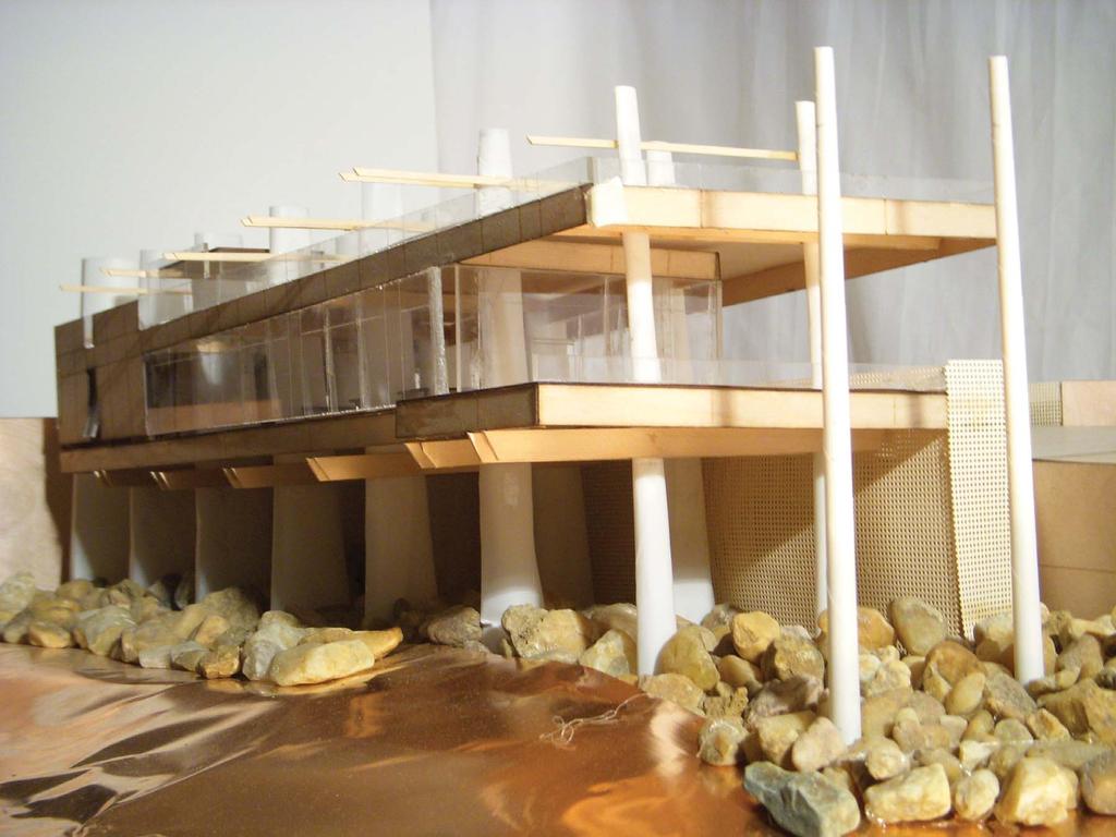
7 147 sketches & iterations 148 ROLL: The design of the two previous buildings influenced the structure of the final building. Piles again emerged as the primary structure, but they began to act differently in this instance.
8 149 sketches & iterations 150 ROLL: When designing I constantly change scale. I work simultaneously in plan, section, elevation, and detail.

9 151 sketches & iterations 152 ROLL: The surrounding area is always an element I never forget. I believe that every building should be site specific. The sketches above show how the jetties work with the building to react to the flow of the water.

10 153 sketches & iterations 154 ROLL: Even though I don t have my roll with me all the time, I still sketch my ideas down and add them to the roll later. In this instance I sketched an idea I had about the structure on a napkin and added it.

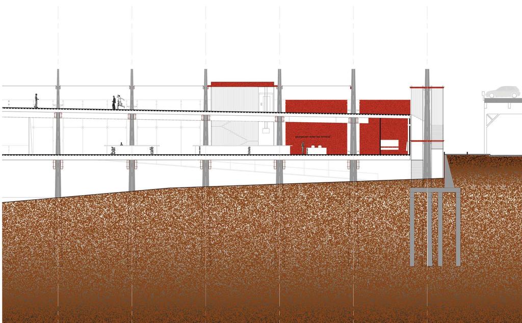
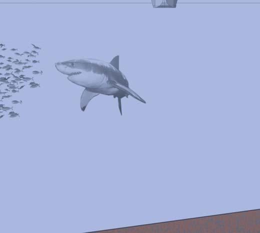
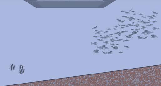
11 Georgetown is located on the Potomac River where a confluence of waters occurs. Salt water from the ocean and fresh water from the mountains converge at the shores of Georgetown. This mixing of waters gives the Potomac River a natural dynamic movement. The concept for this building is not to symbolize the flow, but to react to the currents of the river. The Water Taxi Terminal was inspired by the water taxis that currently travel the river. Tickets are either bought online or at the small ticket booths on the piers. Most of the time the tickets will sell out or there is no one at the booth. As more people move back into the city there is more demand for other forms of transportation. The water taxi route has the potential to connect Maryland and Virginia residents to the city faster than some methods of transportation currently available. The main structure of the building is similar to that of the Visitors Center. Piles support the floors, but each set of piles are different from the next. As the piles travel further into the river they react to the currents that they are exposed to. The water flow on the furthest piles needs to circulate more rapidly than the flow of water on the piles closest to the land. Each set of piles are exposed to different currents and therefore are shaped differently. There are several instances within the building where visitors are encouraged to interact with the piles. The landscape around the terminal also reacts to the currents of the river. Two jetties made from reclaimed stone, protect two beaches that lead visitors from the street to the Potomac River. The origins of the jetty paths come from the adjacent alleys on Waters Street. The terminal and ramp function as the third jetty protecting the beaches from erosion and flood damage. A large ramp continues Wisconsin Avenue into the river. The ramp links the urban environment to the natural flows of the water. The water taxi vessels easily approach and depart from this port, while visitors on the other side of the building enjoy the water as well. Visitors will find that the terminal is more than a ticket booth. After entering directly from the street, visitors will find the information desk and ticket counter on the main 155 floor. Areas that require privacy like restrooms, offices, and maintenance rooms are to the back of the building; while the café, bar, and newsstand are in the front and are concept 156 surrounded by glass walls allowing for views of the Potomac River. The roof of the terminal is a terrace space that is directly accessible from the street. From here, one can get an unobstructed view up and down the Potomac River.


12 water street WISCONSIN AVENUE cecil place capital cresent trail whitehurst freeway 3 1. Vessel ramp 2. Stairs to beaches and terrace 3. Beach 4. Jetties georgetown waterfront park 5. Terrace potomac river 157 site plan


13 WISCONSIN AVENUE 13 WISCONSIN AVENUE 1. Vessel Ramp 2. Entrance Information desk 4. Restroom 5. Mechanical room 6. Office 7. Ticket counter News stand 9. Cafe and Bar Loading platform 11. Circulation 12. Terrace Stairs to beach and terrace main floor plan terrace plan 160 potomac river potomac river 32 64


14 161 model north side model south side 162


15 163 model west side model east side 164

16 165 longitudinal section


17 whitehurst freeway capital crescent trail waters street 167 latteral section


18 b c a 169 details typical pile Visitors are given opprotunities to interact with the piles. 67. window wall An open structure below the floor helps to keep the whole building cool in the summer months. 68. window at pile Operable windows allow for passive ventilation. 8 16


19 69. End of the one of the jetties from above. 70. The jetties are created using reclaimed stones from the foundations of the old Aqueduct Bridge. The outside of the jetties are covered with smaller stones and a concrete sidewalk is poured on top. x 171 jetties
20


21 WISCONSIN AVENUE m street WISCONSIN AVENUE washington aqueduct chesapeake and ohio canal potomac river
Baseball and Books. Master of Architecture. Jacob Tuzzo
 Baseball and Books Jacob Tuzzo Thesis submitted to the faculty of Virginia Polytechnic Institute and State University in partial fulfillment of the requirements of the degree of Master of Architecture
Coastal Hazards Study
 Coastal Hazards Study 2212 Beach Boulevard, Pacifica Prepared for: EXECUTIVE SUMMARY City of Pacifica 170 Santa Maria Ave Pacifica, CA 94044 Prepared by: moffatt & nichol 2185 N. California Blvd. Walnut
Chapter 10 Lecture Outline. The Restless Oceans
 Chapter 10 Lecture Outline The Restless Oceans Focus Question 10.1 How does the Coriolis effect influence ocean currents? The Ocean s Surface Circulation Ocean currents Masses of water that flow from one
RLRC COMMUNITIES EAST GRAND FORKS AREA CHARACTER THE RED LAKE RIVER & THE RED RIVER OF THE NORTH CONFLUENCE EAGLE POINT BOAT LAUNCH DESIGN
 AREA CHARACTER THE RED LAKE RIVER & THE RED RIVER OF THE NORTH CONFLUENCE EAGLE POINT BOAT LAUNCH DESIGN DESIGN DETAILS 135 AREA CHARACTER East Grand Forks a city of 7,501 people is located across the
7/23/2017 VIA . Michael Hanebutt City of Sacramento Community Development Department 300 Richards Boulevard, 3 rd Floor Sacramento, CA 95811
 7/23/2017 VIA EMAIL Michael Hanebutt City of Sacramento Community Development Department 300 Richards Boulevard, 3 rd Floor Sacramento, CA 95811 RE: 65 th Street Apartments (DR17-220) Dear Mr. Hanebutt:
Main Building and raft building viewed from the south side of the Oklahoma River. The white water Main Building anchors the development.
 Client: OKCMAPS Office Completion: April 2016 Scope: Main Building: 16,326 SF Raft Storage Building: 2,041 SF Kayak Storage Building: 1,348 SF Rotary Point Pavilion: 1,387 SF Cost: $45.2 M Awards: RIVERSPORT
AN EARTHWORK HILL, RINGED WITH SEATING AND SHAPED TO SLOPE DOWN TO THE RIVER, FORMS THE CENTERPIECE TO A NEW SOCIAL PIER. A WOOD SEATING TERRACE
 AN EARTHWORK HILL, RINGED WITH SEATING AND SHAPED TO SLOPE DOWN TO THE RIVER, FORMS THE CENTERPIECE TO A NEW SOCIAL PIER. A WOOD SEATING TERRACE FACES SOUTH. A DRAMATIC RAMP RISES ALONG THE NORTH FACE
Hatfield Marine Science Center Quests
 Hatfield Marine Science Center Quests Tsunami Quest 2017 102 The Oregon Coast Book, 2017 18 Edition Use this map of Hatfield Marine Science Center to help you solve the following two Quests! South Beach
HARBOR INFRASTRUCTURE INVENTORIES Marquette Harbor, Michigan
 HARBOR INFRASTRUCTURE INVENTORIES Marquette Harbor, Michigan Harbor Location: Marquette Harbor is located in Marquette Bay on the south shore of Lake Superior, 160 miles west of Sault Ste. Marie, MI and
Redondo Beach Boat Launch Ramp Facility
 Redondo Beach Boat Launch Ramp Facility Feasibility Report for the California Department of Boating and Waterways 2015 Grant Cycle For the City of Redondo Beach Submitted by March 13, 2014 Table of Contents
COURSE MAP
 CHICAGO 2012 URBANATHLON COURSE MAP 1. Plastic Barricades and Police Barricade Combo 2. Cargo Net and Traffic Cones with Poles Combo 3. Police Barricades and Tire Stutter Step Combo 4. Subaru Crawl, Marine
STAGE #3 TRANSITION 1 at Camp Keystone
 STAGE #3 SWIM STAGE #3 TRANSITION 1 at Camp Keystone Mount bike AFTER bump T1 Changing Tent STAGE #3 Camp Keystone to Marineland 68 MILE BIKE STAGE #3 68 MILE BIKE Mile 0-10 SAG 0.0 Turn RIGHT out of T1.
Canoe/Kayak Launch Sites and Accessibility
 Canoe/Kayak Launch Sites and Accessibility Doug Alderson, Paddling Trails Coordinator Division of Recreation and Parks Office of Greenways and Trails Each potential access site on a river, lake or ocean
interchange audit ABERDEEN Introduction Purpose of the Interchange Audit Interchange Audit Linking cycling with public transport
 interchange audit ABERDEEN Bus Station RAILWAY Station FERRY PORT Interchange Audit Susan Warren Jolin Warren 20 March 2014 Linking cycling with public transport Image copyright Boon Low Introduction Purpose
VIII. Project Prioritization & Implementation
 Transportation Plan 2030 July 2006 VIII. Project Prioritization & Implementation Public Transit Service Investigation into the development of a demand responsive service route system through a process
6/14/2013 VIA . Evan Compton, Associate Planner Community Development Department City of Sacramento 300 Richards Blvd Sacramento, CA 95814
 6/14/2013 VIA EMAIL Evan Compton, Associate Planner Community Development Department City of Sacramento 300 Richards Blvd RE: Sacramento Natural Foods Co-Op (P13-025) Dear Mr. Compton: WALKSacramento appreciates
114 The Oregon Coast Book, Edition. Check website for updates: hmsc.oregonstate.edu/quests
 114 The Oregon Coast Book, 2017 18 Edition HMSC Tsunami Quest Established: 2016 by the 7 th grade class at Newport Middle School, with help from their teacher Sean Bedell, Oregon State Parks, and Oregon
HMSC Tsunami Quest. For more information about tsunami safety on the coast, visit Page 1 of 8
 HMSC Tsunami Quest Established: 2016 by the 7 th grade class at Newport Middle School, with help from their teacher Sean Bedell, Oregon State Parks, and Oregon Coast Quests Box monitor: TBD Driving Directions:
Site Analysis and Parti Development
 Site Analysis and Parti Development 32_43 06.11N, 117_09 25.15W Dean Sartain Assignment # 4 AR 650: Programming Instructor: Mirkovich 1. LOCATION within the city. - The site is located between A St & B
Portage Bay Park Design Commission Review 4: 90% Design Development January 5, 2017
 to be updated to reflect base bid condition Portage Bay Park Design Commission Review 4: 90% Design Development January 5, 2017 Previous Site Plan POTENTIAL PARK CONNECTION & MID-BLOCK CROSSING BOAT STREET
Imagine that you can see a side view of a wave as it approaches a beach. Describe how the wave changes as the wave approaches the beach.
 Geology 101 Name Reading Guide for Ch. 19: Shores and Coastal Processes (p. 612) Waves, Currents, and Tides (p. 614) Waves and Currents (p. 614) Imagine that you can see a side view of a wave as it approaches
Building Great Neighbourhoods BELLEVUE AND VIRGINIA PARK
 Building Great Neighbourhoods BELLEVUE AND VIRGINIA PARK This is Meeting 2 Unfortunately, some residents in Bellevue and Virginia Park received the wrong information for this public open house (Meeting
section 4 Existing Conditions, Issues, and Options
 section 4 Existing Conditions, Issues, and Options 4.0 Existing Conditions, Issues, and Options This section analyzes each segment of the corridor on a street to street basis. Each segment is discussed
Niantic Center Elementary School
 Niantic Elementary School is located in the Northwest corner of the intersection of West Main Street and East Pattagansett Road, as so noted on the Facility Location Map. location Overview: The site is
Road Markings. Lecture Notes in Transportation Systems Engineering. Prof. Tom V. Mathew
 Road Markings Lecture Notes in Transportation Systems Engineering Prof. Tom V. Mathew 1 Overview The essential purpose of road markings is to guide and control traffic on a highway. They supplement the
REACTIVATION AND RIPARIAN RESTORATION PROJECT THREE CREEKS CONFLUENCE OPEN SPACE: PRELIMINARY DESIGN CONCEPT #1 J O R D A N R I V E R 900 WEST
 JORDAN RIVER PARKWAY TRAIL DECORATED SHIPPING CONTAINER STORAGE COMMUNITY ART SPACE / EVENT VENUE STALL PARKING LOT / EVENT STAGING "THREE CREEKS OPEN SPACE" SIGN 9 FISHING PIER PLAZA FOOT BRIDGE OVER
ALBERTA AVENUE WHAT WE HEARD REPORT BUILDING GREAT NEIGHBOURHOODS
 ALBERTA AVENUE WHAT WE HEARD REPORT BUILDING GREAT NEIGHBOURHOODS FEBRUARY 2019 EXECUTIVE SUMMARY Starting in 2019, Alberta Avenue will see the replacement and enhancement of its aging collector and local
Controlling Coastal erosion
 Controlling Coastal erosion Coastal Erosion Rates in the U.S. Coastal Erosion and Stabilization Economic pressures demanding the stabilization of beaches and coastlines are immense Coastal Erosion and
VENICE LOCAL COASTAL PROGRAM UPDATE: COASTAL HAZARDS WELCOME
 VENICE LOCAL COASTAL PROGRAM UPDATE: COASTAL HAZARDS WELCOME 1 Introducing the Team Hosted by the Department of City Planning and grant funded in part by the California Coastal Commission 2 Workshop Purpose
CITY OF WOODINVILLE ONGOING CAPITAL IMPROVEMENT PROJECT UPDATES
 CITY OF WOODINVILLE ONGOING CAPITAL IMPROVEMENT PROJECT UPDATES PROJECT LOCATION MAP (1) DEYOUNG PARK IMPROVEMENTS Project Description - DeYoung Park Improvements include treehouse deck, play area, new
Shoreline Studies Program, Department of Physical Sciences, VIMS
 Living Shoreline Training Class 2017 1 Demonstration sites discussed in this talk. 2 A shoreline management plan for the entire creek made conceptual shoreline management recommendations along every stretch
Draft Recommended List of Potential Projects
 Draft Recommended List of Potential Projects To Pursue Using the GID Fund Recommendations are based on results of public outreach, City Council discussion, and staff evaluation of all project ideas identified
Welcome to Paddle for the Edge!
 Welcome to Paddle for the Edge! Thank you for volunteering to conduct a survey of the Barnegat Bay s shorelines. As a citizen scientist, you become part of a project to collect critical data about current
Tsunami Preparedness in the Capital Region
 Tsunami Preparedness in the Capital Region A presentation by: the CRD Local Government Emergency Program Advisory Commission (LG EPAC) and your community emergency programs What is a tsunami? A tsunami
3/20/2015 VIA . Teresa Haenggi, Associate Planner Community Development Department 300 Richards Blvd. Sacramento, CA 95811
 3/20/2015 VIA EMAIL Teresa Haenggi, Associate Planner Community Development Department 300 Richards Blvd. Sacramento, CA 95811 RE: Ice Blocks (P14-062) Dear Ms. Haenggi: WALKSacramento has reviewed the
Keller Williams Realty Marco Island
 Keller Williams Realty Marco Island Standard Lot Size Majority of WI lots are 80x110 Majority of WD lots are 100x110 Estate Lots are typically 125x175 Water Direct vs. Water Indirect Areas of Marco Yacht
SEA LIFE Brighton: Access Statement May 2015
 SEA LIFE Brighton: Access Statement May 2015 INTRODUCTION The SEA LIFE Centre is situated in the heart of Brighton right next to Brighton Pier. It can be seen from the main route into Brighton; London
Thoreau Path Master Plan Final Draft. prepared for: The Boston Redevelopment Authority West End Community November 2007
 Thoreau Path Master Plan Final Draft prepared for: The Boston Redevelopment Authority West End Community November 2007 Introduction Carol R. Johnson Associates ( CRJA ) was retained by the Boston Redevelopment
Blair/Williamson Intersection Expressed Needs
 Blair/Williamson Intersection Expressed Needs NORTH Blair Street is a barrier for pedestrians and bicycles Relocate Capitol City Trail crossing from Blair Street and John Nolen Drive intersection to Williamson
TRANSPORTATION & MOBILITY
 TRANSPORTATION & MOBILITY ROADWAY SYSTEM There are approximately 40 miles of roadways in Manitou Springs. For planning purposes, roadways are typically assigned a functional classification which defines
APPENDIX D-2. Sea Level Rise Technical Memo
 APPENDIX D-2 Sea Level Rise Technical Memo 2185 N. California Blvd., Suite 500 Walnut Creek, CA 94596 (925) 944-5411 Fax: (925) 944-4732 www.moffattnichol.com DRAFT MEMORANDUM To: From: Neil Nichols,
The Sea Geography Notes JC-Learn. JC-Learn. Geography Notes The Sea. 1 P a g e
 JC-Learn Geography Notes The Sea 1 P a g e The Sea *Here, you can choose to study the chapter on glaciation or the one on the sea, or even both, because whenever these topics come up in the Junior Cert
Shorelines Earth - Chapter 20 Stan Hatfield Southwestern Illinois College
 Shorelines Earth - Chapter 20 Stan Hatfield Southwestern Illinois College The Shoreline A Dynamic Interface The shoreline is a dynamic interface (common boundary) among air, land, and the ocean. The shoreline
MEMORANDUM. Existing Operations. City of Clearwater. Michael Herrman. Date: January 26, Seminole Boat Launch Overview. M&N Job No.
 1509 W. Swann Avenue, Suite 225 Tampa, FL 33606 (813) 258-8818 Fax (813) 258-8525 www.moffattnichol.com MEMORANDUM To: From: City of Clearwater Michael Herrman Date: Subject: Seminole Boat Launch Overview
Canal Dock Boathouse, Inc. (CDBi) Paddle-Sports Request for Proposal Q & A Posted to CDBi website 9/16/2017
 Paddle-Sports Request for Proposal Q & A Posted to CDBi website 9/16/2017") Canal Dock Boathouse, Inc. (CDBi) Paddle-Sports Request for Proposal Q & A Posted to CDBi website 9/16/2017 *(All responses below are subject to further scrutiny by the City of New Haven and could be updated
Canal Dock Boathouse, Inc. (CDBi) Paddle-Sports Request for Proposal Q & A Posted to CDBi website 9/16/2017 *(All responses below are subject to further scrutiny by the City of New Haven and could be updated
WHERE. work + life CONNECT
 WHERE work + life CONNECT WORK. CREATE. EXIST. Modern indoor/outdoor office environments bring innovative ideas out in the open. Connecting you to everything you need to live, work and play in downtown
CITY OF NEWPORT BEACH HARBOR COMMISSION STAFF REPORT
 CITY OF NEWPORT BEACH HARBOR COMMISSION STAFF REPORT Agenda Item No. 2 TO: FROM: SUBJECT: HARBOR COMMISSION Harbor Resources Division (City Manager's Office) Chris Miller, Harbor Resources Supervisor,
Q1 Are you a Palisades resident?
 Q1 Are you a Palisades resident? 95.24% 0.68% If no, on what street do yo... 4.08% If no, on what street do you live? (please supply your street name and municipality) 95.24% 140 0.68% 1 4.08% 6 # If no,
Hatfield Marine Science Center Nature Trail Quest
 Hatfield Marine Science Center Nature Trail Quest 118 The Oregon Coast Book, 2019 20 Edition South Beach NOAA Marine Operations Center Marina Store HMSC HMSC Tsunami Sustainability Quest Quest START START
Eilat 's artificial lagoons project on the Red Sea - Israel R. Raviv Ir. R. Raviv, Coastal Engineering Ltd., P.O. Box 7322, z/b 37072,
 Eilat 's artificial lagoons project on the Red Sea - Israel R. Raviv Ir. R. Raviv, Coastal Engineering Ltd., P.O. Box 7322, z/b 37072, Introduction Eilat city is located in the southern part of the state
The Case of the Disappearing Shoreline
 Name The Case of the Disappearing Shoreline Humans change the earth's climate in many ways. One change is the increase of carbon dioxide in the atmosphere. As we burn more fossil fuels, we release more
IMPLEMENTATION WORKBOOK
 Lawrence Township Bicycle and Pedestrian Planning Assistance Study IMPLEMENTATION WORKBOOK Final Action Plan - Part 2 April 2009 Prepared For: The Township of Lawrence and the New Jersey Department of
Public Notice U.S. Army Corps In Reply to Application Number CENAB-OP-RMS (NATIONAL HARBOR (FORMERLY PORT Baltimore District AMERICA])
![Public Notice U.S. Army Corps In Reply to Application Number CENAB-OP-RMS (NATIONAL HARBOR (FORMERLY PORT Baltimore District AMERICA])](/thumbs/89/100795623.jpg "Public Notice U.S. Army Corps In Reply to Application Number CENAB-OP-RMS (NATIONAL HARBOR (FORMERLY PORT Baltimore District AMERICA])") Public Notice U.S. Army Corps In Reply to Application Number of Engineers CENAB-OP-RMS (NATIONAL HARBOR (FORMERLY PORT Baltimore District AMERICA]) 88-01361 PN 14-05 Comment Period: January 16, 2014 to
Public Notice U.S. Army Corps In Reply to Application Number of Engineers CENAB-OP-RMS (NATIONAL HARBOR (FORMERLY PORT Baltimore District AMERICA]) 88-01361 PN 14-05 Comment Period: January 16, 2014 to
SETTINGS AND OPPORTUNITIES MOBILITY & ACCESS
 7 mobility & access how do people use el camino what is it like to drive on el camino/to park along el camino what is the pedestrian experience like what is the role of transit along the corridor what
TRANSPORTATION ALTERNATIVES PROGRAM: SELECTED PROJECTS AND FUNDING ALLOCATIONS
 ITEM #9: TRANSPORTATION ALTERNATIVES PROGRAM: SELECTED PROJECTS AND FUNDING ALLOCATIONS The Transportation Alternatives Program (TAP) created by MAP-21 requires that 50% of the program funds received by
DOWNTOWN TENINO. Goal: Get more People in Downtown. A Pamphlet of Concepts for
 A Pamphlet of Concepts for DOWNTOWN TENINO The Tenino Planning Commission believes that the highest potential for economic development and business development in the City of Tenino (in the short-term)
For more information or permission to reprint slides, please contact Donna Milligan at 1
 For more information or permission to reprint slides, please contact Donna Milligan at milligan@vims.edu 1 For more information or permission to reprint slides, please contact Donna Milligan at milligan@vims.edu
NEWMARKET UPHAM S CORNER
 SOUTH STATION Planning Initiative NEWMARKET UPHAM S CORNER COLUMBIA ROAD (P) FOUR CORNERS/GENEVA Working Advisory Group (WAG) Meeting #5 TALBOT AVENUE MORTON STREET BLUE HILL AVE/CUMMINS HWY (P) RIVER
Chapter - Oceans and Coasts
 Chapter - Oceans and Coasts Discussion: What do oceans contribute to the environment of Earth? How do Earth s major systems relate to the oceans? Oceans and Coasts Oceans are important - Thermal regulation
I am going to visit Titanic Belfast. It is a big, exciting place with lots to see and do. I may travel there by bus, car or walking.
 My Titanic Visit I am going to visit Titanic Belfast. It is a big, exciting place with lots to see and do. I may travel there by bus, car or walking. The building is tall and shiny and reflects the sun.
Coasts. 1. Coastal Processes. 1.1 Coastal erosion. 1.2 Sediment transport. Coastal Processes and Landforms. i. Hydraulic action
 Coasts Coastal Processes and Landforms 1. Coastal Processes 1.1 Coastal erosion i. Hydraulic action When waves strike against a rock surface, the waves trap air in the rock joints. This air is compressed
ADJUSTING TO, FOLLOWING, AND MEETING URBAN TRAFFIC
 Lesson 4 Student Notes 1 ADJUSTING TO, FOLLOWING, AND MEETING URBAN TRAFFIC 1. What two main factors make city driving difficult? There are more cars, buses, trucks, and pedestrians per mile. City hazards
Tsunami Preparedness in the Capital Region
 Tsunami Preparedness in the Capital Region A presentation by: the CRD Local Government Emergency Program Advisory Commission (LG EPAC) and your community emergency programs What is a tsunami? A tsunami
2018 Beach Preservation Project Information
 QUICK FACTS Beach Renourishment to begin late April 2018 o U.S. Army Corps of Engineers project o Project Area: 8 th St. E. to end of E. Ashley Ave. o Project Length: 2 miles o Cost: $10,900,000 o Funding:
Public Access Quarterly Report
 7/7/2017 Public Access Quarterly Report Clean Ocean Access update of 50 CRMC rights-of-way on Aquidneck Island. Contributing Authors: Eva Touhey, Program Manager, Clean Ocean Access Megan Carvalho, Communications
That the agenda for the Colwood Cycling Advisory Committee meeting of Thursday Sept. 8th 2016 be approved as presented. CARRIED.
 CITY OF COLWOOD MINUTES OF COLWOOD CYCLING ADVISORY COMMITTEE MEETING Thursday September 8, 2016 @ 5:00p.m. 3300 Wishart Road Colwood BC Council Chambers DATE: Thursday September 8, 2016 @ 5:00p.m. Committee
Poor pavement condition Substandard Intersections. / Substandard bike/pedestrian/transit accommodations. Driveway access Environmental concerns
 Public Informational Meeting University Avenue (Allen Boulevard Segoe Road) March 23, 2011 City of Madison City of Middleton Village of Shorewood Hills Dane County Existing Roadway Conditions Poor pavement
The Chesapeake Bay as an Estuary: An introduction. Istvan A. Urcuyo Gettysburg College
 The Chesapeake Bay as an Estuary: An introduction. Istvan A. Urcuyo Gettysburg College The Chesapeake Bay -Native Americans resided on its shores since 8000 B.C. The Chesapeake Bay -Original Native American
1. In Reach 3, Perry, Knox, Lowell, and Hooker have crossings identified. What are these?
 Round 3 Integration Plan Integration Plan Public Meeting Denver Urban Waterways Study Meeting Date: Location: Hosted by: Attendees: August 30 2016, 5:30-7:30pm Barnum Recreation Center City and County
Start times: Event Details: Course Updates:
 Hello! Thank you for registering for the upcoming Vallejo Waterfront Weekend Bridge to Bridge Endurance Events. This packet is to help you get ready for this weekend and update everyone on a few things.
Lecture Outlines PowerPoint. Chapter 15 Earth Science, 12e Tarbuck/Lutgens
 Lecture Outlines PowerPoint Chapter 15 Earth Science, 12e Tarbuck/Lutgens 2009 Pearson Prentice Hall This work is protected by United States copyright laws and is provided solely for the use of instructors
San Diego Shorebird Survey Tijuana River Survey Areas
 San Diego Shorebird Survey Tijuana River Survey Areas Legend Survey Area North McCoy South McCoy Helicopter Airfield North River Mouth- Beach North River Mouth-Marsh South River Mouth- Marsh South River
CITY OF SOUTH DAYTONA
 CITY OF SOUTH DAYTONA FIVE YEAR WORK PLAN for HALF-CENT SALES TAX FY 2020-2025 Table of Contents Executive Summary Purpose of the Work Program... 3 Project List Magnolia Avenue North Roadway, Drainage
NAVIGABLE WATERS OF THE UNITED STATES (Section 10 of the Rivers and Harbors Act)
") NAVIGABLE WATERS OF THE UNITED STATES (Section 10 of the Rivers and Harbors Act) Revised March 5, 2010: It amends the old list to address certain waterways that are known to support interstate commerce
NAVIGABLE WATERS OF THE UNITED STATES (Section 10 of the Rivers and Harbors Act) Revised March 5, 2010: It amends the old list to address certain waterways that are known to support interstate commerce
FY 2016 TRANSPORTATION ALTERNATIVES PROGRAM PROJECT SELECTION
 AGENDA ITEM #8: FY 2016 TRANSPORTATION ALTERNATIVES PROGRAM PROJECT SELECTION The Transportation Alternatives Program (TAP) created by MAP-21 requires that 50% of the program funds received by the state
Chapter 12: Coasts (after a brief review of Tides)
") Chapter 12: Coasts (after a brief review of Tides) 1 Questions from previous classes: What happens when a wave meets a current? wave = people walking current = bus If wave goes with the current, the wave
Chapter 12: Coasts (after a brief review of Tides) 1 Questions from previous classes: What happens when a wave meets a current? wave = people walking current = bus If wave goes with the current, the wave
NYS Coastal Waters. Water Resources of NYS: THE NATURE of the COASTAL ZONE. NYS Coastal Waters. NYS Coastal Atlas. Coastal Zone Management 10/10/2014
 Water Resources of NYS: THE NATURE of the COASTAL ZONE NYS Coastal Waters NYS is the only state to border the Atlantic Ocean and the Great Lakes (Lakes Erie and Ontario). Great Lakes shoreline: 577 miles
Driving and Parking with University Parking Permit
 Visitor Information University of California, Berkeley School of Social Welfare 120 Haviland Hall 510-642-4241 (Front Desk) Driving and Parking with University Parking Permit The enclosed F hangtag permit
CITY OF MERCED Planning Department. The City of Merced is currently in the process of crafting a High Speed Rail Station Area Plan.
 AGENDA ITEM I BICYCLE ADVISORY COMMISSION MEETING DATE: August 23, 2016 CITY OF MERCED Planning Department TO: Bicycle Advisory Commission FROM: Bill King, Principal Planner DATE: August 23, 2016 SUBJECT:
Priority 1: Ala Wai Pedestrian and Bicycle Safety and Mobility Project
 Priority 1: Ala Wai Pedestrian and Bicycle Safety and Mobility Project The full application can be found here: http://www.oahumpo.org/wp-content/uploads/2015/05/alawai_application.pdf Description The Ala
For leasing information, contact: Andy Corno Thomas Jackman
 For leasing information, contact: Andy Corno andy.corno@am.jll.com 202-719-6137 Thomas Jackman thomas.jackman@am.jll.com 202-719-5624 This building has taken its place in history, now it s your turn. 600
Hunters Hill to Epping Road
 Hunters Hill to Epping Road 2 hrs 30 mins 5.5 km One way Moderate track 154m An enjoyable walk through lower sections of the Lane Cove National Park, this walk features plenty of mangroves next to the
Modeling Beach Erosion
 Ocean Lecture & Educator s Night May 16, 2012 Modeling Beach Erosion Below is an overview of the activity Modeling Beach Erosion (New Jersey Sea Grant Consortium, Education Program) to incorporate information
11/28/2016 VIA
 11/28/2016 VIA EMAIL Ethan Meltzer, Assistant Planner City of Sacramento Community Development Department 300 Richards Blvd., 3 rd Floor Sacramento, Ca 95811 RE: Natomas Corporate Center Commercial Building
HANGING ROCK STATE PARK EXPANSION MASTER PLAN PHASE TWO INITIAL CONCEPTS INSTRUCTIONS
 ABOUT THE PROJECT The Master Plan for the Expansion of Hanging Rock State Park will create a vision for the nearly 750 acres of land added to the park in 2014. The new property includes Vade Mecum, which
Fitting Light Rail through Well-established Communities
 Fitting Light Rail through Well-established Communities San Francisco 2008 Michael D. Madden Chief, Project Development, Maryland Transit Administration Project Setting Located inside the Capital Beltway
DOWNTOWN MIAMI PEDESTRIAN PRIORITY ZONE
 DOWNTOWN MIAMI PEDESTRIAN PRIORITY ZONE AUGUST 6, 2013 DOWNTOWN MIAMI BY THE NUMBERS more than 200,000 people live, work, and play here every day is home to more than 1,000 events each year hosts more
Comments EXECUTIVE SUMMARY
 Comments 1. Under any Alternatives, MCDOT should provide better at-grade pedestrian crossing of Georgia Avenue and Forest Glen Road, including improved crosswalks with wider medians and adequate signal
100% All Bike DC Loop Ride!
 100% All Bike DC Loop Ride! Ride Leader: Chris Roell Cell Number: 202-607-5565 Ride Social Media Hashtags: #bikedcloop #dcloop #bikedc #exploredc #washingtondc #thedistrict #dc #4thofjulybikeride #4thofjuly
Apostle Islands National Seashore
 Apostle Islands National Seashore David Speer & Phillip Larson October 2 nd Fieldtrip Report Table of Contents Introduction 1 Stop 1: Apostle Island Boat Cruise 1 Stop 2: Coastal Geomorphology 5 Stop 3:
Capital Crescent Trail Crossing at Little Falls Parkway
 M-NCPPC Montgomery Parks Capital Crescent Trail Crossing at Little Falls Parkway INTERSECTION SAFETY IMPROVEMENT STUDY COMMUNITY MEETING JUNE 13, 2018 SOMERSET ELEMENTARY SCHOOL, 7:00-9:00 PM Welcome /
SUPPLEMENTAL DOCUMENT SEA LEVEL RISE SCENARIO SELECTION AND DESIGN TIDE CALCULATION
 SUPPLEMENTAL DOCUMENT SEA LEVEL RISE SCENARIO SELECTION AND DESIGN TIDE CALCULATION FOR THE GUIDANCE FOR INCORPORATING SEA LEVEL RISE INTO CAPITAL PLANNING IN SAN FRANCISCO: ASSESSING VULNERABILITY AND
UNDERWATER BRIDGE INSPECTION REPORT METRO DISTRICT - ANOKA COUNTY
 UNDERWATER BRIDGE INSPECTION REPORT STRUCTURE NO. 02545 CR NO. 116 OVER THE RUM RIVER METRO DISTRICT - ANOKA COUNTY SEPTEMBER 9, 2012 PREPARED FOR THE MINNESOTA DEPARTMENT OF TRANSPORTATION BY COLLINS
To Shape or Serve: Transit & Land Use Forum Tina M. Votaw, Charlotte Area Transit System (CATS)
") To Shape or Serve: Transit & Land Use Forum Tina M. Votaw, Charlotte Area Transit System (CATS) What s the Strategy? Balanced Approach: Invest in both Streets and Transit First to shape, i.e. manage growth
To Shape or Serve: Transit & Land Use Forum Tina M. Votaw, Charlotte Area Transit System (CATS) What s the Strategy? Balanced Approach: Invest in both Streets and Transit First to shape, i.e. manage growth
including infrastructure, transit and open space, Open Space changed approximately 50 to approximately 60
 Draft North Branch Framework Plan s The below table itemizes changes made to the North Branch Industrial Corridor Framework and Design Guidelines. The original draft was posted March 17, 2017. This table
LAB: WHERE S THE BEACH
 Name: LAB: WHERE S THE BEACH Introduction When you build a sandcastle on the beach, you don't expect it to last forever. You spread out your towel to sunbathe, but you know you can't stay in the same spot
Oceans and Coasts. Chapter 18
 Oceans and Coasts Chapter 18 Exploring the oceans The ocean floor Sediments thicken and the age of the seafloor increases from ridge to shore The continental shelf off the northeast United States Constituent
MARCH 2005 PERFORMANCES DRIVING DIRECTIONS
 All dancers must arrive (generally) 30 minutes before performance time as noted after each performance location and wait quietly before dancing. Dancers who do not arrive on time for a performance may
Introduction. Who is WILMAPCO. Why are walkable communities important
 Walkable Community Workshops Round 1 April 2005 SPONSORED BY WILMAPCO AND CCOBH CITY OF NEW CASTLE EDGEMOOR GARDENS CIVIC ASSOCIATION WITH FUNDING BY DELAWARE DEPARTMENT OF TRANSPORTATION AND THE DELAWARE
Running Southwest Florida Beaches. By Eddie Underhill
 Running Southwest Florida Beaches By Eddie Underhill Intro: 1. For years I have been running Fort Myers Beach. I live at Fairview Isles, so I start at the beach here in front of the Gullwing Hotel and