Refraction and shoaling analysis Using diffraction graphs Case studies Homer Spit RCPWAVE analysis Nikiski STWAVE analysis
|
|
|
- Leonard Carter
- 6 years ago
- Views:
Transcription

1 Module 5 Orson P. Smith, PE, Ph.D. Professor Emeritus Refraction and shoaling analysis Using graphs Case studies Homer Spit RCPWAVE analysis Nikiski STWAVE analysis Orson Smith, PE, Ph.D., Instructor 1


2 Consider straight wave crests approaching shallow water at an angle Part of crest slows before rest Crest bends in toward shore Snell s Law: sin C sin cos cos 0 0 C0 C C0 Refraction Coefficient: K r cos 0 H H KsKr H cos 0 0 C 2C 0 0 g cos cos Orson Smith, PE, Ph.D., Instructor 2
3 Variation of C and at contour of arbitrary orientation (fig. 5.2 & eqn in text) 1 1 In terms of 2 : Solve this for each single depth cell in grid Curvature of wave ray depends on gradient of C normal to wave direction: ray bends toward lower C Lateral transfer of wave energy into a geometric shadow Orson Smith, PE, Ph.D., Instructor 3
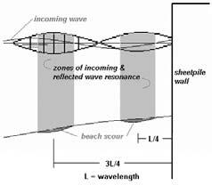
; S max = 75 (swell) y/l x/l Orson Smith, PE, Ph.")
4 Figures in CEM Part II, Ch. 7, after: Goda, Y., Random Seas and Design of Maritime Structures, 3 rd ed., Advanced Series on Ocean Engineering: Volume 33, World Scientific S max = 10 (wind waves, i.e., seas); S max = 75 (swell) y/l x/l Orson Smith, PE, Ph.D., Instructor 4
5 Figures in CEM Part II, Ch. 7, after Goda (2010) B/L = gap wavelength ratio period height B Figures in CEM Part II, Ch. 7, after Goda (2010) B/L = gap wavelength ratio period height ratio Orson Smith, PE, Ph.D., Instructor 5
 B/L = gap wavelength")

6 Figures in CEM Part II, Ch. 7, after Goda (2010) B/L = gap wavelength ratio Figures in CEM Part II, Ch. 7, after Goda (2010) B/L = gap wavelength ratio Orson Smith, PE, Ph.D., Instructor 6


 Orson Smith,")
7 prevailing longshore sediment transport Coos Bay, Oregon Rogue River entrance, Oregon Case Study A: 1985 Ref. Smith et al, 1985 (Waterways Experiment Station report) Orson Smith, PE, Ph.D., Instructor 7


8 Module 5 Working with refraction and Orson Smith, PE, Ph.D., Instructor 8


9 Orson Smith, PE, Ph.D., Instructor 9

")
10 RCPWAVE numerical wave refraction, shoaling, and breaking model Steady state, linear waves monochromatic No open coast use only Ref. Smith et al, 1985 (Waterways Experiment Station report) Orson Smith, PE, Ph.D., Instructor 10


11 Case Study B: Orson Smith, PE, Ph.D. Professor, UAA School of Engineering Alexander Khokhlov, MS Candidate, Dept. of Civil Engineering, UAA School of Engineering William J. Lee, Research Associate and Ph.D. candidate, Environmental Engineering Program, UAA School of Engineering Steven Buchanan, RLS, Instructor, Dept. of Geomatics, UAA School of Engineering Orson Smith, PE, Ph.D., Instructor 11
 Chevron Environmental Management Company (San Ramon, CA) Phase I Scope Investigate")

12 Project Sponsors Geomega, Inc. (Boulder, CO) Chevron Environmental Management Company (San Ramon, CA) Phase I Scope Investigate geomorphologic change through history of the site and survey data measured by UAA Sample and classify beach materials Characterize wave climate Numerical simulations of nearshore wave transformation Interpret geomorphologic changes with regard to local conditions Orson Smith, PE, Ph.D., Instructor 12

13 East Foreland Rigtenders Dock Mean Mean Spring Tide North West Range Range Level Station Latitude Longitude (ft) (ft) (ft) Ushagat Island, Barren Islands 58 57' ' SELDOVIA, Kachemak Bay 59 27' ' Homer, Kachemak Bay 59 38' ' Anchor Point 59 46' ' Cape Ninilchik 60 01' ' Ninilchik 60 03' ' Kenai River entrance 60 33' ' Kenai City Pier 60 33' ' Nikiski 60 41' ' East Foreland 60 43' ' Sunrise, Turnagain Arm 60 54' ' ANCHORAGE, Knik Arm 61 14' ' North Foreland 61 03' ' Drift River Terminal 60 34' ' Oil Bay, Kamishak Bay 59 38' ' Orson Smith, PE, Ph.D., Instructor 13
 knots 2.57 10-19 (15) knots 7.72 20-29 (25) knots 12.86 30-39 (35) knots 18.")

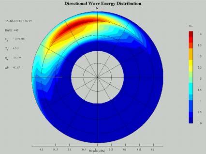
14 Composite hourly data Kenai Airport ( ) KPC Terminal, Nikiski ( ) Radial scale is percent frequency of occurrence Radial bands indicate 10 knot wind speed classes acting toward the center Wind rose analysis software and graphic by Josh Rogers, UAA School of Engineering Wind Speed Speed m/sec 0-9 (5) knots (15) knots (25) knots (35) knots (45) knots (55) knots Wave parameter 180 deg deg 225 deg deg 270 deg deg 315 deg H T H T H T H T H T H T calculated using CEDAS ACES wave prediction software ( Veri Tech, Inc.) Orson Smith, PE, Ph.D., Instructor 14
 Extremal wave analysis by Heike Merkel from previous study sponsored by PN&D, Inc.")
 to 10 tenths (100% ice cover) and hatch patterns to indicate stage of development (from Cook Inlet Ice Atlas by CRREL and UAA for")
15 Extreme Waves Offshore of the Mouth of the Kenai River, Probability of H<H' Estimated Function Data, Wave Height, H' (ft) Extremal wave analysis by Heike Merkel from previous study sponsored by PN&D, Inc., and City of Kenai Beach ice grows in upper tidelands and floats free to form sediment laden conglomerates Average ice conditions 1 15 February, showing color codes of concentration from 0 (no ice) to 10 tenths (100% ice cover) and hatch patterns to indicate stage of development (from Cook Inlet Ice Atlas by CRREL and UAA for NOAA, 2000) Orson Smith, PE, Ph.D., Instructor 15


16 Sample No. 3, 4, 6, & #4: substrate below #3 Percent Finer #3: surface just north of dock #6: surface, just south of open-cell wall #7: surface 40 ft off southern open-cell wall Grain Size, mm Samples collected by Alexander Khokhlov Analysis by Curtis Townsend, UAA Civil Engineering student Orson Smith, PE, Ph.D., Instructor 16


 NAD 83 586800 587000 587200 587400 587600 6728800")


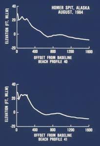
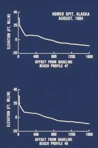
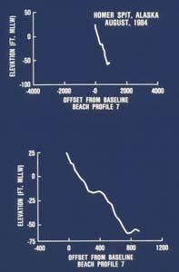
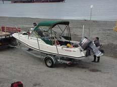
17 # # # # # # # # # # # Module 5 Working with refraction and MLLW , 4 1, N Meters Feet UTM Zone 5 (Meters) NAD Topographic survey: Steve Buchanan, RLS, Heike Merkel, Alissa Pempek, Josh Rogers, Alexander Khokhlov Hydrographic survey: Bill Lee, Alexander Khokhlov, Orson Smith Low tide view of North inshore corner of Rigtenders Dock, July Orson Smith, PE, Ph.D., Instructor 17


18 Grid developed by Alexander Khokhlov and Bill Lee from NOAA archives and UAA 2002 survey data for STWAVE simulations Steady state linear waves Evolution of directional spectrum Multiple waves of different H, T, and Non linear transfer of energy within spectrum Bottom friction, percolation, wind input, simple current interaction, breaking Diffraction past simple structures Orson Smith, PE, Ph.D., Instructor 18

.")


 blocks")
19 STWAVE output for Hs = 5.45 m, Tp = 9.09 sec, direction = 225 T (from southwest). Arrows are wave rays, contours are wave height, and colors are depths at mean tide level. Climatic average condition: H = 0.6 m (2 ft), T = 4.2 sec, direction = 24 Northward Beach barrier (Rigtenders Dock) blocks longshore transport from South Orson Smith, PE, Ph.D., Instructor 19

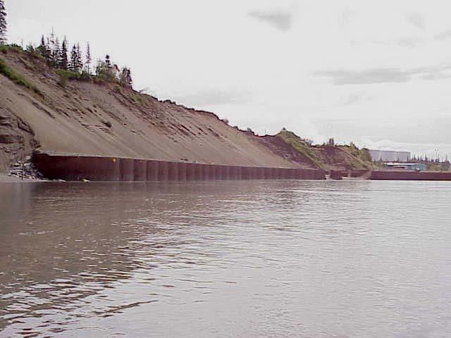
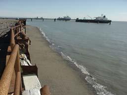
20 Offshore margin of Rigtenders Dock at low tide. Orson Smith, PE, Ph.D., Instructor 20


21 Phase II Scope Extended numerical simulations 2 nd topographic & hydrographic survey Quantitative analysis of annual change Wave measurements Evaluation assumptions based on hindcast wave climatology Discuss alternative engineering responses to erosion Example BMAP analysis of profile change and of beach fill configurations Example BMAP analysis of profile change and of beach fill configurations Orson Smith, PE, Ph.D., Instructor 21

22 Orson Smith, PE, Ph.D., Instructor 22 Not For Navigational Use Not Fo N E W S58 46'58 52'58 58'59 2'59 6'59 10'59 16'59 22'59 28'59 34'59 40'59 46'59 52'59 58'60 2'60 6'60 10'60 16'60 22'60 28'60 34'60 40'60 46'60 52'60 58'61 2'61 6'61 10'61 16'61 22'154 48'154 48'154 36'154 36'154 24'154 24'154 12'154 12'154 00'154 00'153 48'153 48'153 36'153 36'153 24'153 24'153 12'153 12'153 00'153 00'152 48'152 48'152 36'152 36'152 24'152 24'152 12'152 12'152 00'152 00'151 48'151 48'151 36'151 36'151 24'151 24'151 12'151 12'151 00'151 00'150 48'150 48'1515Grid development by Alexander Khokhlov and Bill Lee, UAA/SOE NOAA Chart NOAA Chart 16640


23 Orson Smith, PE, Ph.D., Instructor 23


24 Orson Smith, PE, Ph.D., Instructor 24


25 Seawall Orson Smith, PE, Ph.D., Instructor 25
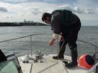
26 Data collected from 2003/06/09 13:36:40 to 2003/07/18 11:36: sea state measurements, 8.41 MB Sample rate = 2 Hz, burst length = 1,024 seconds (2048 samples) every 2 hours Spectral analysis: Frequency minimum = 0.04 Hz, Ensemble average every 128 samples Hanning type smoothing of ensembles Wave height (from ADP data) and Wind speed (from NOAA database) Nikiski (06/09/ /18/2003) Wind speed (m/s) Wave height (m) Date 6/10/2003 6/11/2003 6/12/2003 6/13/2003 6/14/2003 6/14/2003 6/15/2003 6/16/2003 6/17/2003 6/18/2003 6/19/2003 6/20/2003 6/21/2003 6/22/2003 6/23/2003 6/24/2003 6/25/2003 6/25/2003 6/26/2003 6/27/2003 6/28/2003 6/29/2003 6/30/2003 7/1/2003 7/2/2003 7/3/2003 7/4/2003 7/5/2003 7/6/2003 7/6/2003 7/7/2003 7/8/2003 7/9/2003 7/10/2003 7/11/2003 7/12/2003 7/13/2003 7/14/2003 7/15/2003 7/16/2003 7/17/2003 7/17/2003 Date Wind Speed (m/s) Wave Height (m) Analysis and graph by Alexander Khokhlov, UAA/SOE Orson Smith, PE, Ph.D., Instructor 26

27 Orson Smith, PE, Ph.D., Instructor 27
Sea State Analysis. Topics. Module 7 Sea State Analysis 2/22/2016. CE A676 Coastal Engineering Orson P. Smith, PE, Ph.D.
 Sea State Analysis Module 7 Orson P. Smith, PE, Ph.D. Professor Emeritus Module 7 Sea State Analysis Topics Wave height distribution Wave energy spectra Wind wave generation Directional spectra Hindcasting
Beach Profiles. Topics. Module 9b Beach Profiles and Crossshore Sediment Transport 3/23/2016. CE A676 Coastal Engineering
 Beach Profiles AND CROSS-SHORE TRANSPORT Orson P. Smith, PE, Ph.D., Professor Emeritus Topics Features of beach and nearshore profiles Equilibrium profiles Cross-shore transport References Text (Sorensen)
Longshore sediment transport
 and Orson P. Smith, PE, Ph.D., Professor Emeritus Longshore transport Waves breaking at an angle to shore Sediment under breakers lifted by saltation Drops back to sea bed a little down drift Swash (runup)
Appendix E Cat Island Borrow Area Analysis
 Appendix E Cat Island Borrow Area Analysis ERDC/CHL Letter Report 1 Cat Island Borrow Area Analysis Multiple borrow area configurations were considered for Cat Island restoration. Borrow area CI1 is located
Available online at ScienceDirect. Procedia Engineering 116 (2015 )
") Available online at www.sciencedirect.com ScienceDirect Procedia Engineering 116 (2015 ) 320 325 8th International Conference on Asian and Pacific Coasts (APAC 2015) Department of Ocean Engineering, IIT
Available online at www.sciencedirect.com ScienceDirect Procedia Engineering 116 (2015 ) 320 325 8th International Conference on Asian and Pacific Coasts (APAC 2015) Department of Ocean Engineering, IIT
DUXBURY WAVE MODELING STUDY
 DUXBURY WAVE MODELING STUDY 2008 Status Report Duncan M. FitzGerald Peter S. Rosen Boston University Northeaster University Boston, MA 02215 Boston, MA 02115 Submitted to: DUXBURY BEACH RESERVATION November
Modeling Sediment Transport Along the Upper Texas Coast
 Modeling Sediment Transport Along the Upper Texas Coast David B. King Jr. Jeffery P. Waters William R. Curtis Highway 87 roadbed, Jefferson County Galveston District Corps Sabine Pass to San Luis Pass
IMPACTS OF COASTAL PROTECTION STRATEGIES ON THE COASTS OF CRETE: NUMERICAL EXPERIMENTS
 IMPACTS OF COASTAL PROTECTION STRATEGIES ON THE COASTS OF CRETE: NUMERICAL EXPERIMENTS Tsanis, I.K., Saied, U.M., Valavanis V. Department of Environmental Engineering, Technical University of Crete, Chania,
Kauai Wave Climate. Jessica Podoski, PE USACE Honolulu District
 Kauai Wave Climate Jessica Podoski, PE USACE Honolulu District Kauai Wave Climate Overview Study Regions WIS Hindcast Data & Analysis Wave Transformation NearshoreWave Climate Kauai Study Regions KekahaWave
Wave Propagation and Shoaling
 Wave Propagation and Shoaling Focus on movement and natural alteration of the characteristics of waves as they travel from the source region toward shore Waves moving from deep to intermediate/shallow
Imagine that you can see a side view of a wave as it approaches a beach. Describe how the wave changes as the wave approaches the beach.
 Geology 101 Name Reading Guide for Ch. 19: Shores and Coastal Processes (p. 612) Waves, Currents, and Tides (p. 614) Waves and Currents (p. 614) Imagine that you can see a side view of a wave as it approaches
MIAMI BEACH 32ND STREET HOT SPOT: NUMERICAL MODELING AND DESIGN OPTIMIZATION. Adam Shah - Coastal Engineer Harvey Sasso P.E.
 ABSTRACT MIAMI BEACH 32ND STREET HOT SPOT: NUMERICAL MODELING AND DESIGN OPTIMIZATION Adam Shah - Coastal Engineer Harvey Sasso P.E. - Principal Coastal Systems International, Inc. 464 South Dixie Highway
MAR 110 LECTURE #15 Wave Hazards
 1 MAR 110 LECTURE #15 Wave Hazards Rogue Wave Hazard Rogue waves are very large open ocean waves of sometimes can range in height from 60 ft (20m) to120 feet (40m) and thus a significant hazard to large
Evaluation of June 9, 2014 Federal Emergency Management Agency Flood Insurance Study for Town of Weymouth, Norfolk, Co, MA
 Evaluation of June 9, 2014 Federal Emergency Management Agency Flood Insurance Study for Town of Weymouth, Norfolk, Co, MA Prepared For: Woodard & Curran 95 Cedar Street, Suite 100 Providence, RI 02903
HURRICANE SANDY LIMITED REEVALUATION REPORT UNION BEACH, NEW JERSEY DRAFT ENGINEERING APPENDIX SUB APPENDIX D SBEACH MODELING
 HURRICANE SANDY LIMITED REEVALUATION REPORT UNION BEACH, NEW JERSEY DRAFT ENGINEERING APPENDIX SUB APPENDIX D SBEACH MODELING Rev. 18 Feb 2015 1 SBEACH Modeling 1.0 Introduction Following the methodology
INTRODUCTION TO COASTAL ENGINEERING AND MANAGEMENT
 Advanced Series on Ocean Engineering Volume 16 INTRODUCTION TO COASTAL ENGINEERING AND MANAGEMENT J. William Kamphuis Queen's University, Canada World Scientific Singapore New Jersey London Hong Kong Contents
Reading Material. Inshore oceanography, Anikouchine and Sternberg The World Ocean, Prentice-Hall
 Reading Material Inshore oceanography, Anikouchine and Sternberg The World Ocean, Prentice-Hall BEACH PROCESSES AND COASTAL ENVIRONMENTS COASTAL FEATURES Cross section Map view Terminology for Coastal
SHORELINE EVOLUTION DUE TO HIGHLY OBLIQUE INCIDENT WAVES AT WALVIS BAY, NAMIBIA
 SHORELINE EVOLUTION DUE TO HIGHLY OBLIQUE INCIDENT WAVES AT WALVIS BAY, NAMIBIA Berry Elfrink, 1 Gordon Prestedge 2, Cesar B.M. Rocha 3, and Jørgen Juhl 4 Abstract: This paper describes the development
SHORE PROTECTION AND HABITAT CREATION AT SHAMROCK ISLAND, TEXAS ABSTRACT
 SHORE PROTECTION AND HABITAT CREATION AT SHAMROCK ISLAND, TEXAS M. Cameron Perry, P.E., and Daniel J. Heilman, P.E. Coastal Engineer Shiner Moseley & Associates., Inc. 555 N. Carancahua Corpus Christi,
ABSTRACT. KEY WORDS: Navigation safety; numerical modeling; waves; current; sediment transport; channel infilling; morphology change.
 The 25th (2015) International Polar and Engineering Conference Li, H., L. Lin, Z. Demirbilek, T. M. Beck, and H. R. Moritz (2015). Wave-Current Conditions and Navigation Safety at an Inlet Entrance. The
CROSS-SHORE SEDIMENT PROCESSES
 The University of the West Indies Organization of American States PROFESSIONAL DEVELOPMENT PROGRAMME: COASTAL INFRASTRUCTURE DESIGN, CONSTRUCTION AND MAINTENANCE A COURSE IN COASTAL DEFENSE SYSTEMS I CHAPTER
APPENDIX G WEATHER DATA SELECTED EXTRACTS FROM ENVIRONMENTAL DATA FOR BCFS VESSEL REPLACEMENT PROGRAM DRAFT REPORT
 APPENDIX G WEATHER DATA SELECTED EXTRACTS FROM ENVIRONMENTAL DATA FOR BCFS VESSEL REPLACEMENT PROGRAM DRAFT REPORT Prepared for: B.C. Ferries Services Inc. Prepared by: George Roddan, P.Eng. Roddan Engineering
Preliminary Design of an Artificial Surfing Reef for Cocoa Beach, Florida
 Preliminary Design of an Artificial Surfing Reef for Cocoa Beach, Florida J. Hearin Florida Institute of Technology 150 W. University Boulevard Melbourne, FL 32901 USA johnhearin@yahoo.com ABSTRACT This
Appendix D: SWAN Wave Modelling
 Appendix D: SWAN Wave Modelling D.1 Preamble The Eurobodalla Shire Council area is subject to extreme waves originating from offshore storms. When swell waves approach the coast, they are modified by the
Preliminary Wake Wash Impact Analysis Redwood City Ferry Terminal, Redwood City, CA
 Technical Memorandum Preliminary Wake Wash Impact Analysis Redwood City Ferry Terminal, Redwood City, CA 1. Introduction The following preliminary wake wash impact analysis was initiated by the Port of
Unsteady Wave-Driven Circulation Cells Relevant to Rip Currents and Coastal Engineering
 Unsteady Wave-Driven Circulation Cells Relevant to Rip Currents and Coastal Engineering Andrew Kennedy Dept of Civil and Coastal Engineering 365 Weil Hall University of Florida Gainesville, FL 32611 phone:
Artificial headlands for coastal restoration
 Artificial headlands for coastal restoration J. S. Mani Professor, Department of Ocean Engineering, Indian Institute of Technology Madras, Chennai 636, India Abstract Construction of a satellite harbour
Coastal Wave Energy Dissipation: Observations and Modeling
 Coastal Wave Energy Dissipation: Observations and Modeling Jeffrey L Hanson US Army Corps of Engineers Field Research Facility USACE Field Research Facility Kent K. Hathaway US Army Corps of Engineers
Directional Wave Spectra from Video Images Data and SWAN Model. Keywords: Directional wave spectra; SWAN; video images; pixels
 Jurnal Teknologi Full paper Directional Wave Spectra from Video Images Data and SWAN Model Muhammad Zikra a*, Noriaki Hashimoto b, Masaru Yamashiro b, Kojiro Suzuki c a Department of Ocean Engineering,
Wave Transformation Modeling with Bottom Friction Applied to the Southeast Oahu Reefs. Mary A. Cialone and Jane McKee Smith
 Wave Transformation Modeling with Bottom Friction Applied to the Southeast Oahu Reefs Mary A. Cialone and Jane McKee Smith Outline Objective Study Area STWAVE Friction Formulations Model Validation Summary
Coastal & Marine Environment. Chapter. Wave Transformation. Mazen Abualtayef Assistant Prof., IUG, Palestine
 Coastal & Marine Wave Transformation Mazen Abualtayef Assistant Prof., IUG, Palestine Wave Transformation Wave transformation describes what happens to waves as they travel from deep into shallow water
Currents measurements in the coast of Montevideo, Uruguay
 Currents measurements in the coast of Montevideo, Uruguay M. Fossati, D. Bellón, E. Lorenzo & I. Piedra-Cueva Fluid Mechanics and Environmental Engineering Institute (IMFIA), School of Engineering, Research
Nearshore Dredged Material Placement Pilot Study at Noyo Harbor, CA
 1 Nearshore Dredged Material Placement Pilot Study at Noyo Harbor, CA Noyo Cove N 2011 National Conference on Beach Preservation Technology 9-11, February 2011 Lihwa Lin, Honghai Li, Mitchell Brown US
Chapter 10 Lecture Outline. The Restless Oceans
 Chapter 10 Lecture Outline The Restless Oceans Focus Question 10.1 How does the Coriolis effect influence ocean currents? The Ocean s Surface Circulation Ocean currents Masses of water that flow from one
Analysis of Extreme Wave Climates in Rhode Island Waters South of Block Island
 8. Analysis of Extreme Wave Climates in Rhode Island Waters South of Block Island By Annette R. Grilli, Taylor G. Asher, Stephan T. Grilli and Malcolm L. Spaulding Ocean Engineering University of Rhode
Oceans and Coasts. Chapter 18
 Oceans and Coasts Chapter 18 Exploring the oceans The ocean floor Sediments thicken and the age of the seafloor increases from ridge to shore The continental shelf off the northeast United States Constituent
/50. Physical Geology Shorelines
 Physical Geology Shorelines Multiple Guess: (You know the drill 2 points each) 1. The path of movement of a water particle in a wave at sea is 1. circular 2. horizontal 3. vertical 4. elliptical 5. none
WAVE AND CURRENT HYDRODINAMICS STUDY AT BATANG AIR DINGIN RIVER MOUTHPADANG, INDONESIA
 International Journal of Civil Engineering and Technology (IJCIET) Volume 9, Issue 11, November 2018, pp. 2054 2062, Article ID: IJCIET_09_11_202 Available online at http://www.iaeme.com/ijciet/issues.asp?jtype=ijciet&vtype=9&itype=11
WAVE MECHANICS FOR OCEAN ENGINEERING
 Elsevier Oceanography Series, 64 WAVE MECHANICS FOR OCEAN ENGINEERING P. Boccotti Faculty of Engineering University of Reggio-Calabria Feo di Vito 1-89060 Reggio-Calabria Italy 2000 ELSEVIER Amsterdam
Tides. Tides: longest waves. or seas. or ripples
 Tides or ripples or seas Tides: longest waves Tides Definition: The rise and fall of sea level due to the gravitational forces of the Moon and Sun and the rotation of the Earth. Why tides are important?
To: William Woods, Jenni Austin Job No: CentrePort Harbour Deepening Project - Comments on community queries
 Memo To: William Woods, Jenni Austin From: Richard Reinen-Hamill Date: Subject: cc: 1 Purpose This memo sets out our response to issues raised at and after Seatoun community consultation sessions held
Lecture Outlines PowerPoint. Chapter 15 Earth Science, 12e Tarbuck/Lutgens
 Lecture Outlines PowerPoint Chapter 15 Earth Science, 12e Tarbuck/Lutgens 2009 Pearson Prentice Hall This work is protected by United States copyright laws and is provided solely for the use of instructors
page - Laboratory Exercise #5 Shoreline Processes
 page - Laboratory Exercise #5 Shoreline Processes Section A Shoreline Processes: Overview of Waves The ocean s surface is influenced by three types of motion (waves, tides and surface currents). Shorelines
Advanced Series on Ocean Engineering - Volume 14 COASTAL STABILIZATION. Richard Silvester John R C Hsu. \v? World Scientific
 Advanced Series on Ocean Engineering - Volume 14 COASTAL STABILIZATION Richard Silvester John R C Hsu \v? World Scientific Contents PREFACE xv 1 INTRODUCTION 1 /. / Coastal Environment 2 J.2 State of Beach
Numerical Simulation of Wind Wave Field
 Numerical Simulation of Wind Wave Field Lihwa Lin 1, Ray-Qing Lin 2, and Jerome P.Y. Maa 3 1 U.S. Army Engineer Research and Development Center 3909 Halls Ferry Road, Vicksburg, MS. 39180 2 David Taylor
Waves. Types of Waves. Parts of a wave. Insert wind_wave.wmv. Shark attack
 Waves Recall: Waves = transmitted energy What causes waves? Wind gravity Earthquakes We will talk about all of these, but first Insert wind_wave.wmv Shark attack Types of Waves Body waves transmit energy
LATLAS. Documentation
 LATLAS Documentation 27.07.2017 1. Project's presentation The LATLAS project aims at supplying an interactive Internet platform with an atlas of waves for the main Swiss lakes. The characteristics of waves
Numerical modeling of refraction and diffraction
 Numerical modeling of refraction and diffraction L. Balas, A. inan Civil Engineering Department, Gazi University, Turkey Abstract A numerical model which simulates the propagation of waves over a complex
PUV Wave Directional Spectra How PUV Wave Analysis Works
 PUV Wave Directional Spectra How PUV Wave Analysis Works Introduction The PUV method works by comparing velocity and pressure time series. Figure 1 shows that pressure and velocity (in the direction of
Figure 1 Example feature overview.
 1. Introduction This case focuses on the northeastern region of Onslow Bay, NC, and includes an initial shoreline, regional contour, wave gauges, inlets, dredging, and beach fills. Most of the features
Tedious Creek Small Craft Harbor: CGWAVE Model Comparisons Between Existing and Authorized Breakwater Configurations
 Tedious Creek Small Craft Harbor: CGWAVE Model Comparisons Between Existing and Authorized Breakwater Configurations by Michael J. Briggs, Barbara P. Donnell, Zeki Demirbilek, and Robert D. Carver PURPOSE:
OECS Regional Engineering Workshop September 29 October 3, 2014
 B E A C H E S. M A R I N A S. D E S I G N. C O N S T R U C T I O N. OECS Regional Engineering Workshop September 29 October 3, 2014 Coastal Erosion and Sea Defense: Introduction to Coastal Dynamics David
MONITORING SEDIMENT TRANSPORT PROCESSES AT MANAVGAT RIVER MOUTH, ANTALYA TURKEY
 COPEDEC VI, 2003 in Colombo, Sri Lanka MONITORING SEDIMENT TRANSPORT PROCESSES AT MANAVGAT RIVER MOUTH, ANTALYA TURKEY Isikhan GULER 1, Aysen ERGIN 2, Ahmet Cevdet YALCINER 3 ABSTRACT Manavgat River, where
Deep-water orbital waves
 What happens when waves approach shore? Deep-water orbital waves Fig. 9.16, p. 211 Wave motion is influenced by water depth and shape of the shoreline wave buildup zone surf zone beach Wave base deepwater
Determination Of Nearshore Wave Conditions And Bathymetry From X-Band Radar Systems
 Determination Of Nearshore Wave Conditions And Bathymetry From X-Band Radar Systems Okey G. Nwogu Dept. of Naval Architecture and Marine Engineering University of Michigan Ann Arbor, MI 489 phone: (734)
Analysis of Extreme Wave Climates in Rhode Island Waters South of Block Island
 Analysis of Extreme Wave Climates in Rhode Island Waters South of Block Island By T.G. Asher, A.R. Grilli, S.T. Grilli and M.L. Spaulding Ocean Engineering University of Rhode Island Prepared for Ocean
Wave Energy Atlas in Vietnam
 Wave Energy Atlas in Vietnam Nguyen Manh Hung, Duong Cong Dien 1 1 Institute of Mechanics, 264 Doi Can Str. Hanoi, Vietnam nmhungim@gmail.com; duongdienim@gmail.com Abstract Vietnam has achieved remarkable
CHAPTER 134 INTRODUCTION
 CHAPTER 134 NEW JETTIES FOR TUNG-KANG FISHING HARBOR, TAIWAN Chi-Fu Su Manager Engineering Department Taiwan Fisheries Consultants, Inc. Taipei, Taiwan INTRODUCTION Tung-Kang Fishing Harbor, which is about
CHAPTER 59 USE OF VOLCANOES FOR DETERMINATION OF DIRECTION OF LITTORAL DRIFT. Per Bruun and Gxsli Viggosson The Technical University of Norway
 CHAPTER 59 USE OF VOLCANOES FOR DETERMINATION OF DIRECTION OF LITTORAL DRIFT By Per Bruun and Gxsli Viggosson The Technical University of Norway Abstract - The title of this paper may sound like a ;joke
Generalized Wave-Ray Approach for Propagation on a Sphere and Its Application to Swell Prediction
 Generalized Wave-Ray Approach for Propagation on a Sphere and Its Application to Swell Prediction D. Scott 1, D. Resio 2, and D. Williamson 1 1. & Associates 2. Coastal Hydraulic Laboratory, U.S. Army
Chapter 8 Wave climate and energy dissipation near Santa Cruz Island, California
 Chapter 8 Wave climate and energy dissipation near Santa Cruz Island, California NATHAN BURLEY A* AND ROBYN SUDDETH B A CIVIL & ENVIRONMENTAL ENGINEERING B GRADUATE GROUP IN HYDROLOGIC SCIENCES UNIVERSITY
BEACH PROCESSES AND COASTAL ENVIRONMENTS
 BEACH PROCESSES AND COASTAL ENVIRONMENTS COASTAL FEATURES Cross section Map view TOPICS: Terminology Waves Beach Morphology Barriers Coastal Migration Tides Tidal Flats and Marshes Sediment Budgets Human
COASTAL EROSION: INVESTIGATIONS IN THE SOUTHWEST COAST OF SRI LANKA
 COASTAL EROSION: INVESTIGATIONS IN THE SOUTHWEST COAST OF SRI LANKA Wijayawardane I.S.K. 1, Ansaf K.M.M. 2, Ratnasooriya A.H.R. 3, Samarawickrama S.P. 4 1,2 Postgraduate Student, Department of Civil Engineering,
Inlet Management Study for Pass-A-Grille and Bunces Pass, Pinellas County, Florida
 Inlet Management Study for Pass-A-Grille and Bunces Pass, Pinellas County, Florida Final Report Submitted By Ping Wang, Ph.D., Jun Cheng Ph.D., Zachary Westfall, and Mathieu Vallee Coastal Research Laboratory
Technical Brief - Wave Uprush Analysis Island Harbour Club, Gananoque, Ontario
 Technical Brief - Wave Uprush Analysis RIGGS ENGINEERING LTD. 1240 Commissioners Road West Suite 205 London, Ontario N6K 1C7 October 31, 2014 Table of Contents Section Page Table of Contents... i List
CHAPTER 6 DISCUSSION ON WAVE PREDICTION METHODS
 CHAPTER 6 DISCUSSION ON WAVE PREDICTION METHODS A critical evaluation of the three wave prediction methods examined in this thesis is presented in this Chapter. The significant wave parameters, Hand T,
BILLY BISHOP TORONTO CITY AIRPORT PRELIMINARY RUNWAY DESIGN COASTAL ENGINEERING STUDY
 Bâtiment Infrastructures municipales Transport Industriel Énergie Environnement BILLY BISHOP TORONTO CITY AIRPORT PRELIMINARY RUNWAY DESIGN COASTAL ENGINEERING STUDY N. Guillemette 1, C. Glodowski 1, P.
Shorelines Earth - Chapter 20 Stan Hatfield Southwestern Illinois College
 Shorelines Earth - Chapter 20 Stan Hatfield Southwestern Illinois College The Shoreline A Dynamic Interface The shoreline is a dynamic interface (common boundary) among air, land, and the ocean. The shoreline
Technical Brief - Wave Uprush Analysis 129 South Street, Gananoque
 Technical Brief - Wave Uprush Analysis 129 South Street, Gananoque RIGGS ENGINEERING LTD. 1240 Commissioners Road West Suite 205 London, Ontario N6K 1C7 June 12, 2013 Table of Contents Section Page Table
Chapter 11 Tides. A tidal bore is formed when a tide arrives to an enclosed river mouth. This is a forced wave that breaks.
 Chapter 11 Tides A tidal bore is formed when a tide arrives to an enclosed river mouth. This is a forced wave that breaks. Tidal range can be very large Tide - rhythmic oscillation of the ocean surface
PHYSICAL AND NUMERICAL MODELLING OF WAVE FIELD IN FRONT OF THE CONTAINER TERMINAL PEAR - PORT OF RIJEKA (ADRIATIC SEA)
") PHYSICAL AND NUMERICAL MODELLING OF WAVE FIELD IN FRONT OF THE CONTAINER TERMINAL PEAR - PORT OF RIJEKA (ADRIATIC SEA) DALIBOR CAREVIĆ (1), GORAN LONČAR (1), VLADIMIR ANDROČEC (1) & MARIN PALADIN (1) 1.
PHYSICAL AND NUMERICAL MODELLING OF WAVE FIELD IN FRONT OF THE CONTAINER TERMINAL PEAR - PORT OF RIJEKA (ADRIATIC SEA) DALIBOR CAREVIĆ (1), GORAN LONČAR (1), VLADIMIR ANDROČEC (1) & MARIN PALADIN (1) 1.
A Preliminary Review of Beach Profile and Hardbottom Interactions
 A Preliminary Review of Beach Profile and Hardbottom Interactions Douglas W. Mann, P.E., D.CE. CB&I A World of Solutions Presentation Goal Lead to a better understanding of the challenges regarding the
( max)o Wind Waves 10 Short Swell (large wave steepness) 25 Long Swell (small wave steepness) 75
o Wind Waves 10 Short Swell (large wave steepness) 25 Long Swell (small wave steepness) 75") CEPi-I-18 REvKn, 3188 IRREGULAR WAVE DIFFRACTION BY GODA'S KETHOD PURPOSE : To provide a simplified method for determining random wave diffraction coefficients for a semi-infinite breakwater. GENERAL :
CEPi-I-18 REvKn, 3188 IRREGULAR WAVE DIFFRACTION BY GODA'S KETHOD PURPOSE : To provide a simplified method for determining random wave diffraction coefficients for a semi-infinite breakwater. GENERAL :
Ocean Waves. Capillary. Gravity. Wind generated. Tides Tsunamis Seiches
 Ocean Waves Capillary Wind generated Gravity Tides Tsunamis Seiches Capillary waves are driven by the surface tension produced by electrically polarized water molecule San Pedro Lighthouse Waves are alternate
Nearshore Sediment Transport What influences the loss of sediment on Beaches? - Waves - Winds - Tidal Currents - River discharge - Runoff
 Tides & Beaches Nearshore Sediment Transport What influences the loss of sediment on Beaches? - Waves - Winds - Tidal Currents - River discharge - Runoff Oceans Ocean Topography Physical Structure of the
Aalborg Universitet. Estimation of wave conditions at Liseleje location Bogarino, Bruno; Brorsen, Michael. Publication date: 2007
 Aalborg Universitet Estimation of wave conditions at Liseleje location Bogarino, Bruno; Brorsen, Michael Publication date: 27 Document Version Publisher's PDF, also known as Version of record Link to publication
Volume and Shoreline Changes along Pinellas County Beaches during Tropical Storm Debby
 Volume and Shoreline Changes along Pinellas County Beaches during Tropical Storm Debby Ping Wang and Tiffany M. Roberts Coastal Research Laboratory University of South Florida July 24, 2012 Introduction
Chapter 10 Waves. wave energy NOT the water particles moves across the surface of the sea. wave form moves and with it, energy is transmitted
 Capillary Waves, Wind Waves, Chapter 10 Waves Anatomy of a Wave more like a real wave Tsunamis, Internal waves big waves huge waves rogue waves small waves more like a sine wave Wave direction Wave wave
Surface Waves NOAA Tech Refresh 20 Jan 2012 Kipp Shearman, OSU
 Surface Waves NOAA Tech Refresh 20 Jan 2012 Kipp Shearman, OSU Outline Surface winds Wind stress Beaufort scale Buoy measurements Surface Gravity Waves Wave characteristics Deep/Shallow water waves Generation
Chapter. The Dynamic Ocean
 Chapter The Dynamic Ocean An ocean current is the mass of ocean water that flows from one place to another. 16.1 The Composition of Seawater Surface Circulation Surface Currents Surface currents are movements
Determination of Nearshore Wave Conditions and Bathymetry from X-Band Radar Systems
 Determination of Nearshore Wave Conditions and Bathymetry from X-Band Radar Systems Okey G. Nwogu Dept. of Naval Architecture and Marine Engineering University of Michigan Ann Arbor, MI 48109 Phone: (734)
ENERGY OF WAVES ch.1 PRACTICE TEST
 ENERGY OF WAVES ch.1 PRACTICE TEST Multiple Choice Identify the choice that best completes the statement or answers the question. 1. If a wave is traveling at a certain speed and its frequency is doubled,
ENGINEERING STUDY OF INLET ENTRANCE HYDRODYNAMICS: GRAYS HARBOR, WASHINGTON, USA
 Cialone, M.A., and Kraus, N.C. (2001). Engineering Study of Inlet Entrance Hydrodynamics: Grays Harbor, Washington, USA. Proceedings of Coastal Dynamics 01, ASCE, Reston, VA, 413-422. ENGINEERING STUDY
OCEAN WAVES NAME. I. Introduction
 NAME OCEAN WAVES I. Introduction The physical definition of a wave is a disturbance that transmits energy from one place to another. In the open ocean waves are formed when wis blowing across the water
General Coastal Notes + Landforms! 1
 General Coastal Notes + Landforms! 1 Types of Coastlines: Type Description Primary Coast which is essentially in the same condition when sea level stabilized Coastline after the last ice age, younger.
(Refer Slide Time: 0:36)
") Port and Harbour Structures. Professor R. Sundaradivelu. Department of Ocean Engineering. Indian Institute of Technology, Madras. Module-2. Lecture-8B. Wave Rose Diagram. (Refer Slide Time: 0:36) We will
Port and Harbour Structures. Professor R. Sundaradivelu. Department of Ocean Engineering. Indian Institute of Technology, Madras. Module-2. Lecture-8B. Wave Rose Diagram. (Refer Slide Time: 0:36) We will
COASTAL ENVIRONMENTS. 454 lecture 12
 COASTAL ENVIRONMENTS Repeated movement of sediment & water constructs a beach profile reflecting the balance between average daily or seasonal wave forces and resistance of landmass to wave action Coasts
Ocean Waves and Surf Forecasting: Wave Climate and Forecasting
 Overview Ocean Waves and Surf Forecasting: Wave Climate and Forecasting Ocean regions Characterizing and describing ocean waves Wave theory, propagation, and dispersion Refraction, shadowing, and bathymetry
Shoreline Evolution Due to Oblique Waves in Presence of Submerged Breakwaters. Nima Zakeri (Corresponding Author), Mojtaba Tajziehchi
, Mojtaba Tajziehchi") Shoreline Evolution Due to Oblique Waves in Presence of Submerged Breakwaters Nima Zakeri (Corresponding Author), Mojtaba Tajziehchi Department of Civil Engineering, Faculty of Engineering, University
Shoreline Evolution Due to Oblique Waves in Presence of Submerged Breakwaters Nima Zakeri (Corresponding Author), Mojtaba Tajziehchi Department of Civil Engineering, Faculty of Engineering, University
LOCALLY CONCENTRATED SEVERE BEACH EROSION ON SEISHO COAST CAUSED BY TYPHOON T0709
 F-4 Fourth International Conference on Scour and Erosion 2008 LOCALLY CONCENTRATED SEVERE BEACH EROSION ON SEISHO COAST CAUSED BY TYPHOON T0709 Yoshimitsu TAJIMA 1 and Shinji SATO 2 1 Member of JSCE, Associate
G. Meadows, H. Purcell and L. Meadows University of Michigan
 www.coj.net/departments/fire+and+rescue/emergency+preparedness/rip+current.htm G. Meadows, H. Purcell and L. Meadows Over 80% of all surf related rescues are attributable to Rip Currents According to the
Development and Implementation of a Relocatable Coastal and Nearshore Modeling System
 Development and Implementation of a Relocatable Coastal and Nearshore Modeling System James M. Kaihatu Zachry Department of Civil Engineering, Texas A&M University 3136 TAMU College Station, TX 77843-3136
Swell and Wave Forecasting
 Lecture 25 Swell and Wave Forecasting Swell and Wave Forecasting Motivation Terminology Wave Formation Wave Decay Wave Refraction Shoaling Rouge Waves 1 2 Motivation In Hawaii, surf is the number one weather-related
APPENDIX A APPENDIX B APPENDIX C APPENDIX D APPENDIX E APPENDIX F APPENDIX G SEDIMENT ANALYSIS APPENDIX A WAVE & SEDIMENT MODELS CRYSTAL BALL ANALYSIS
 APPENDIX A WAVE & SEDIMENT MODELS APPENDIX B SEDIMENT ANALYSIS APPENDIX A WAVE & SEDIMENT MODELS APPENDIX C CRYSTAL BALL ANALYSIS APPENDIX D SBEACH ANALYSIS APPENDIX E GENESIS ANALYSIS APPENDIX F PREFERRED
Metocean criteria for fatigue assessment. Rafael V. Schiller 5th COPEDI Seminar, Oct 8th 2014.
 Metocean criteria for fatigue assessment Rafael V. Schiller 5th COPEDI Seminar, Oct 8th 2014. Metocean requirements along the lifecycle of a project Metocean criteria for fatigue Analysis techniques and
Potential Impacts of Sand Mining Offshore of Maryland and Delaware: Part 1 Impacts on Physical Oceanographic Processes
 Journal of Coastal Research 2 1 44 6 West Palm Beach, Florida Winter 24 Potential Impacts of Sand Mining Offshore of Maryland and Delaware: Part 1Impacts on Physical Oceanographic Processes Jerome P.-Y.
Questions # 4 7 refer to Figure # 2 (page 321, Fig )
") Shoreline Community College OCEANOGRAPHY 101 Fall 2006 Sample Exam # 3 Instructor: Linda Khandro Questions # 1 3 refer to Figure # 1 (page 284, Fig 11.7) 1. At which position is the moon in its new moon
Shoreline Community College OCEANOGRAPHY 101 Fall 2006 Sample Exam # 3 Instructor: Linda Khandro Questions # 1 3 refer to Figure # 1 (page 284, Fig 11.7) 1. At which position is the moon in its new moon
Wave Transmission at Detached Breakwaters for Shoreline Response Modeling
 Wave Transmission at Detached Breakwaters for Shoreline Response Modeling by Ty Wamsley, Hans Hanson, and Nicholas C. Kraus PURPOSE: The Coastal and Hydraulics Engineering Technical Note (CHETN) herein
Undertow - Zonation of Flow in Broken Wave Bores
 Lecture 22 Nearshore Circulation Undertow - Zonation of Flow in Broken Wave Bores In the wave breaking process, the landward transfer of water, associated with bore and surface roller decay within the
MAR 110 LECTURE #20 Storm-Generated Waves & Rogue Waves
 MAR 110 LECTURE #20 Storm-Generated Waves & Rogue Waves Wave Principles Review Figure 20.1 Wave Principles (ABOVE) A simple ocean surface wave is a sea level distortion that repeats itself over a distance