Evaluation of Ebb-Tidal Shoals as a Sand Source for Beach Nourishment: General Methodology with Reservoir Model Analysis
|
|
|
- Erica Wood
- 6 years ago
- Views:
Transcription
1 Evaluation of Ebb-Tidal hoals as a and ource for each Nourishment: General Methodology with Reservoir Model Analysis Mohamed A. Dabees 1 and Nicholas C. Kraus 2 1 Humiston& Moore Engineers, 5679 trand Court, Naples, FL md@humistonandmoore.com 2 U.. Army Engineer Research and Development Center, Coastal and Hydraulics Laboratory, 3909 Halls Ferry Road, Vicksburg, M Nicholas.C.Kraus@usace.army.mil Abstract Morphologic features of tidal inlets, such as ebb shoals and flood shoals, are attractive potential sources of sediment for beach nourishment because of their close proximity to shore and the probable compatibility of sediment grain size and color with those of the neighboring beaches. Removal of sediment by mining will, however, interrupt the natural sediment bypassing of the integrated sediment-sharing system. Until recently, the consequences of mining inlets were difficult to estimate. The Inlet Reservoir Model is a new technology that can estimate alterations in growth of inlet morphologic features and changes in the bypassing rate in response to mining of ebb- and flood-tidal shoals. This paper describes a general methodology incorporating bathymetric data and aerial photography, operation of wave and tidal circulation numerical models, and application of the Reservoir Model to examine the response of complex inlet system, Capri Pass, Florida, to proposed sediment mining to nourish the downdrift Hideaway each. The Reservoir Model provided estimates of the reduction in natural bypassing and the time lag for recovery to the pre-mining condition. Through application of such a methodology, which is applicable to any tidal inlet, alternatives for the location of mining and acceptable amount of volume to be taken can be evaluated and compared quantitatively. INTRODUCTION Ebb shoals typically contain substantial quantities of beach-quality material and offer a potentially significant economic advantage as a borrow source over offshore sources because of proximity to the beach. However, ebb shoals are part of an interactive morphologic system that evolves towards dynamic equilibrium under sediment transport produced by waves and tidal currents. Mature ebb shoals allow a maximum amount of sand to bypass an inlet to the downdrift beach. Mehta, et al. (1996) reviewed the acting processes, listed inlets in Florida where ebb shoals have been mined, and identified needs for predictive technology to assess the consequences of ebb-shoal mining. Dredging of inlets for navigation channel maintenance and mining of ebb shoals for beach nourishment interrupts natural bypassing and may contribute to inlet-related beach erosion. Cialone and tauble (1998) reviewed eight ebb-shoal mining projects on the Atlantic and Gulf coasts. Their analysis indicates varying responses ranging from beneficial to detrimental. The main detrimental impact was chronic downdrift beach erosion at some sites. Mixed outcomes of 1


2 previous projects and lack of tools to assess consequences make potential for adverse consequences of ebb-shoal mining a concern to permitting agencies. As a result, regulatory agencies may be cautious and resist or reject proposed use of ebb shoals as a sand source. Challenges in sand management near inlets include the complexity of coastal processes at inlets and lack of guidelines and tools to quantify the various responses of the system to mining of ebb shoals and channel dredging for beach nourishment. Timeframes for such responses are a central factor because, in dealing with large sand shoals, adjustment in bypassing and morphology may require many years. Monitoring programs and mitigation measures must be designed with awareness of these long time lags. Research is underway to establish practical modeling tools and guidelines for access to ebb shoals as sand sources. The Inlet Reservoir Model (Kraus 2000a, 2000b) is such a new analytical tool developed to quantify volume change of inlet features and sediment pathways at ebb-tidal and related inlet shoals. The model provides estimates of ebb-shoal evolution and natural bypassing rates at inlets. It can also predict the time response of the bypassing rate and shoal recovery rate as a consequence of ebb-shoal mining (and flood-shoal mining). The model has been applied to address engineering issues at several sites, including Ocean City Inlet, Maryland (Kraus 2000a,b), hinnecock Inlet, New York, (Militello and Kraus 2001), Fire Island Inlet, New York (Kraus et al. 2003), and ebastian Inlet, Florida (Zarillo, et al. 2003). This paper presents an application of the Inlet Reservoir Model to a complex inlet system. A general approach is taken in applying a variety of engineering models and analysis procedures to evaluate the morphologic evolution and bypassing of Capri Pass, Florida. The analysis assesses the potential of its ebb shoal as a sand source for restoration of the down-drift beach, Hideaway each. ACKGROUND Capri Pass is the major tidal inlet of a multi-inlet system that includes Little Marco Pass, Capri Pass, and ig Marco Pass (Figure 1). The three inlets connect Johnson ay and ig Marco River to the Gulf of Mexico. Capri Pass and ig Marco Pass have been regarded as a dual inlet system (Van de Kreeke 1990) because the two inlets are separated by a small island (Coconut Island) and by a large and complex ebb shoal system. Large-scale changes in this inlet system over the past five decades have influenced the evolution of Hideaway each (Humiston 1988). Hideaway each is located between Royal Marco Point and outh point on the northwest end of Marco Island along the Gulf of Mexico coastline. GULF OF MEXICO AND DOLLAR ILAND 2 Coconut Island IG MARCO PA outh Point EA OAT ILAND JOHNON CAPRI PA AY IG MARCO RIVER Royal Marco Point M AR C O I L AN D LITTLE MARCO PA Figure 1. Project location NAPLE FLORIDA

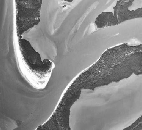
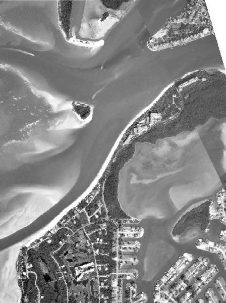
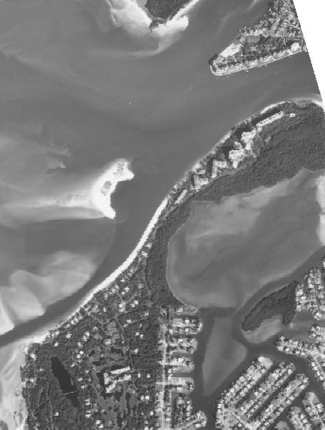
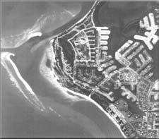
3 Figure 2. Photographic documentation inlet evolution 3

4 elected aerial photographs of Capri Pass and ig Marco Pass inlet system from 1952 to 1999 are arranged in Figure 2. As shown in the 1952 photograph, Coconut Island was part of ea Oat Island, and ig Marco Pass was the only inlet. At that time, ig Marco Pass carried all of the tidal flow, as well as freshwater discharge from the ig Marco River. The tidal prism is estimated to be approximately 1,200 million cu ft on an average tide (Van de Kreeke 1990). In 1967, Capri Pass opened approximately 2,000 ft to the north of ig Marco Pass. ince that time, Capri Pass has continued to increase in size as it captures greater shares of the tidal and fresh water flows. In the process, Coconut Island and ea Oat Island eroded, and some of that sand was deposited on the new ebb shoal forming around Capri Pass. This shift in flow from ig Marco Pass to Capri Pass has resulted in the ebb shoal of ig Marco Pass migrating towards Marco Island. y 1990, Coconut Island had been reduced to approximately 10% of its 1967 area. However, during the following years, Coconut Island started to regain volume while continuing to migrate southwest. y 1996, the width of Capri Pass was approximately 2,000 ft, which exposed Royal Marco Point to waves incident from the Gulf of Mexico. The wave energy window, as illustrated in Figure 3, generated unidirectional sediment transport from west to east with little supply of sediment from the west due to the presence of a shadow zone from Coconut Island and the shoal system. y 1997, the growth and migration of Coconut Island created a large shadow zone on Hideaway each that reduced sand supply toward royal Marco Point. Monitoring in year 2000 showed that Coconut Island continued to migrate southwest and ea Oat Island continued to erode as the width of Capri Pass increased from about 2,000 ft to approximately 3,200 ft. Hydrodynamic modeling results for this regional multi-inlet system indicate that the percentages of tidal prism flowing through Little Marco Pass, Capri Pass, and ig Marco Pass are 7, 90, and 3% respectively. REGIONAL MORPHOLOGIC FEATURE Regional and local surveys covered the inlet system for 1994, 2000, and Figure 4 gives a perspective view of the inlet system and distinct features. The figure shows the multiple channels and large size of Capri Pass compared to the narrower and longer channels of Little Marco Pass and ig Marco Pass. The quality and extent of the data sets allowed identification of distinct morphologic features that appeared in all data sets. In addition, Comparisons between data sets quantified elevation change and evolution trends in the ebb-shoal features. Figure 5 Gulf of Mexico Wave Energy Coconut Island ea Oat Island ig Marco Pass Capri Pass Johnson ay ig Marco River Royal Marco Point hadow zone Figure 3. Illustration of wave energy and sediment transport at Royal Marco point (1996 conditions) 4
5 shows the elevation change between 1994 and 2003, indicating the deepening and widening of Capri Pass, growth of the ebb shoal features, and sedimentation (shoaling) of big Marco Pass. The figure also illustrates the migration of Coconut Island (the small island that separates Capri Pass and big Marco Pass) towards Marco Island. The collapse of the derelict shoal of big Marco Pass supplying sand to the attachment bar (and Dollar Island) is also seen. Little Marco Pass Johnson ay ea Oat Island Coconut Island Gulf of Mexico ig Marco River Capri Pass and Dollar Island ig Marco Pass Marco Island Figure 4. Regional features of the inlet system (2003 condition) 5
 Coconut Island Coconut Island is selected for discussion, as it represents a significant feature in the evolution of the inlet system and sediment pathways.")
6 Little Marco Pass Johnson ay ea Oat Island Coconut Island Gulf of Mexico ig Marco River Capri Pass and Dollar Island ig Marco Pass Marco Island Figure 5. Regional elevation changes ( ) Coconut Island Coconut Island is selected for discussion, as it represents a significant feature in the evolution of the inlet system and sediment pathways. Coconut Island is a small island located between two tidal inlets and exposed to direct wave action from the Gulf of Mexico. The evolution of Coconut Island has direct bearing on the fate of Hideaway each as described in the ackground section. Wave and tidal current modeling were performed to evaluate the forces that are influencing the morphologic evolution of Coconut Island. ince 1998, Coconut Island shoreline has been approximately 1,000 ft long with an orientation normal to the predominantly NW window of wave exposure. From 1998 until 2003, Coconut Island shoreline has steadily receded parallel to itself, at a rate of 32 ft/year, while forming growing spits at both ends (Figure 6). 6
.")
7 Figure 6. Coconut Island shoreline positions ( ) Wave refraction modeling explains this process. When wave arrive from N to NW, their breaking drives sediment transport to the W, eroding the shoreline and forming the W spit (Figure 7). On the other hand, when wave arrive from W and W, the sediment transport along Coconut Island shoreline is towards the NW, forming the other spit (Figure 8). ecause the predominant wave direction is from NW, the W spit is larger than the NW spit of Coconut Island. The wave analysis and sediment transport for this area are given in Dabees et al. (2002) and H&M (2003). The analysis indicates that without the presence of tidal currents, Coconut Island might have been over-washed by waves and attached to Hideaway each. However, strong tidal currents through ig Marco Pass are still preventing Coconut Island from attaching to Hideaway each (Appendix A). Circulation modeling results indicate that tidal currents at the W spit of Coconut Island are sufficiently strong to prevent Coconut Island from attaching. The results also show the ebb current through ig Marco Pass flows more around Coconut Island into the Gulf rather than through the channel of ig Marco Pass. The calculated circulation pattern explains the sedimentation (shoaling) of ig Marco Pass and reduced share of tidal prism flowing through it. 7


8 Figure 7. Wave refraction results for NNW direction Figure 8. Wave refraction results for W direction 8


9 CAPRI PA REERVOIR MODEL APPLICATION The Inlet Reservoir Model (Kraus 2000a, 2000b) calculates the volume change and bypassing rates for an inlet ebb-shoal complex. Other inlet morphologic features can also be represented. The first step is to identify sediment pathways across the ebb shoal delta and the distinct morphologic features that form the ebb shoal. In a typical wave-dominated inlet, there would be three distinct ocean-side features: an ebb shoal, bypassing bar, and attachment bar. The concept of the Reservoir Model is based on the assumption that each feature has a maximum sand -retention capacity cannot be exceeded. Once a feature has reached capacity, all additional sediment transport to that feature will bypass to the next feature(s), and so forth until sediment arrives at the downdrift side of the inlet or other location, such as the channel and flood shoal. If a morphologic feature is partially full, it still provides (partial) bypassing. The Reservoir Model calculates the growth of the shoals as a function of the littoral drift and the equilibrium volumes of the shoals, and the model accounts for the naturally long timescales of large morphologic features and time delays in transport of material among the features. Detailed discussion of the Reservoir Model can be found in Kraus (2000a, 2000b, 2002). Figure 9. Aerial photo of 1969 conditions This ebb-shoal system the subject study site is more complex than that of a typical inlet. This is because Capri Pass opened in 1967 near ig Marco Pass, which had a mature ebb shoal for the same tidal prism that is now mainly carried by Capri Pass. During the time the ebb shoal system of Capri Pass was created, the large volume of sand in big Marco Pass was moving onshore. Figure 9 is an aerial photo of the inlet system in 1969, 2 years after the opening of Capri Pass. The Figure 10. Comparison between 1965 and 2003 conditions extent of the derelict ig Marco Pass hoal and formation of Capri Pass and shoal are observed. Rapid formation of Capri Pass shoal and slow collapse of ig Marco Pass shoal resulted in an ebb shoal volume in excess of the equilibrium volume as estimated from the tidal prism. Figure 10 shows a comparison between the shoreline of 1965 prior to the pass opening with the 2003 conditions. A large portion of ea Oat Island has eroded to give way to the growing Capri Pass. and from ea Oat Island contributed to the growth of Capri Pass ebb shoal. 9

.")
10 Reservoir Model setup Establishment of the Reservoir Model for Capri Pass involved several challenges: 1. Unlike typical cases where features grow to an equilibrium volume, some features had decayed or reformed from the derelict ig Marco Pass shoal. 2. More sources of sand contributed to the system than just the littoral drift, including: o sand from erosion of ea Oat Island through opening, widening, and deepening of Capri Pass, and o the derelict ebb shoal of ig Marco Pass supplying sand to evolving features and to Marco Island as the shoal collapses (migrates onshore). The Reservoir Model was enhanced to include an assigned or specified source or drain rate for a given feature. In this way, the supply of sand for eroding shores such ea Oat Island and derelict features such as 1967-ig Marco Pass ebb shoal can be represented. ediment Pathways The wave, sediment transport, and tidal hydrodynamic modeling, in addition to the bathymetry data, were inspected to define the sediment pathways for this complex inlet system. Figures 11 and 12 show the correlation between ebb current flow and sedimentation patterns indicated by the elevation change between 1994 and Figure 11. Ebb current velocities Figure 12. Elevation change ( ) 10
11 Figure 11 shows the ebb current flow at the Gulf low water level. ackground colors are displayed on for flow below the critical velocity where sediment movement occurs. Figure 12 shows the documented elevation change between 1994 and 2003, yellow and red areas indicate deposition, whereas blue shades indicate erosion or scour. ased on the modeling results and documented elevation change, the present-condition sediment pathways for predominant southward transport can be represented as illustrated in Figure 13. As the southward sediment transport bypasses Capri Pass ebb shoal, it follows two separate paths; one towards Coconut Island and the other towards Marco Island attachment bar (and Dollar Island). The Coconut Island pathway continues through the two spits at the ends of Coconut Island to bypass some sand to Hideaway each and ig Marco Pass. The sand bypassed from the W spit of Coconut Island continues to fill in the channel of ig Marco Pass. The NE spit bypasses sand to the east end of Hideaway each near Collier ay entrance. The Marco Island pathway bypasses sand to and Dollar Island and eventually to the Gulf coastline of Marco Island. Morphologic Features Defining morphologic features and sediment pathways is central to successful application of the Reservoir Model. reaking up the ebb shoal complex into several morphologic features was necessary as sediment pathways evolved with morphologic features. The bathymetric data considered together with modeling results defined the distinct morphologic features in the system. The equilibrium volume of each feature was determined based on comparisons of available surveys and calculated volumes and rates of change for each feature. The ebb shoal complex on the south side of Capri Pass was divided into several features to represent the time lag in growth and decay of various features in the system. Marco Island Pathway Q in Coconut Island Pathway Q out ig Marco Pass Figure 13. ediment pathways A Attachment -ypassing C-Channel D-Derelict E-Ebb -hore O -Offshore Y -ay O Q in and Dollar Island D E A Marco Island C C Collier ay Entrance Q out Figure 14. Morphologic features and sediment pathways Y 11

. Other model parameters such as a feature s drain or supply rates were determined based on documented observations and measurements.")
12 Figure 14 shows the morphologic features and sediment pathways for the predominant southward transport direction. imilarly, the northward transport was also represented in the model. The equilibrium volume of each feature was determined based on available surveys and rates of volume change in each feature. The input sediment transport rates were specified as 170,000 cy/year to the south and 100,000 cy/year to the north, based on wave and sediment transport analysis and previous estimates by Van de Kreeke (1990). Other model parameters such as a feature s drain or supply rates were determined based on documented observations and measurements. For instance, Coconut Island drain rate was specified at 18,000 cy/year based on documented erosion rates discussed earlier. Reservoir Model Results The measured and calculated volumes for Capri Pass ebb shoal are shown in Figure 15. The results indicate the ebb shoal volume is approaching its equilibrium size of approximately 7 million cy. The measured volumes for the years 2000 and 2003 represent close to approximately 90% of the estimated equilibrium volume. A Attachment D-Derelict O Offshore -ypassing E-Ebb Y ay C-Channel -hore Q in Y O E C D C A Q out Figure 15. Capri Pass Ebb hoal volume Calculated and measured volumes of Coconut Island are shown in Figure 16. The model results match the observed and measured trends of change to Coconut Island. Immediately after the opening of Capri Pass in 1967, Coconut Island was subjected to continuing erosion due to wave action and tidal currents as discussed in ackground. In the absence of bypassed material to Coconut Island, erosion and southward migration continued until Coconut Island reached its minimum size in During this period, the bypassing bar to Coconut Island was forming, and the bypassing rates increasing to begin offsetting the erosion. As the bypassing rates continued to increase, Coconut Island began to grow to its present size. However, the model also predicts future decay of Coconut Island as the bypassed volumes decrease, after the excess volume of the derelict shoal features and sand supply from ea Oat Island diminish. In addition, sedimentation of ig Marco Pass would reduce the strong tidal currents that are keeping Coconut Island from attaching to Hideaway each. 12


13 A Attachment -ypassing C-Channel D-Derelict E-Ebb -hore O-Offshore Y -ay Q in Y O E C D C A Q out 1967 Capri Pass opened Figure 16. Coconut Island volume A Attachment -ypassing C-Channel D-Derelict E-Ebb -hore O-Offshore Y-ay Q in Y O E C D C A Q out Figure 17. and Dollar Island Volume 13

14 Figure 17 shows the calculated and measured volumes for the attachment bar and Dollar Island. The measured volumes were determined based on aerial photos and available survey data. The data indicate that and Dollar Island emerged by 1980 and continued to grow and migrate shoreward to its current position. The model indicates that the island has reached equilibrium volume and is bypassing sand to Marco Island Gulf-side coast. A sediment drain (decay) rate was not specified for and Dollar Island. There is a probability of future decay of and Dollar Island, after the sand supply from the derelict ebb shoal of ig Marco Pass is greatly diminished. Consequence of Mining Capri Pass Ebb hoal as a and ource Volume measurements and supplementary data were available to validate the Reservoir Model application for Capri Pass. Thus, the model can be operated to evaluate engineering activities such as the proposed use of the ebb shoal as a source for 240,000 cy of sand nourishment to Hideaway each. Given the resolution of the model and the possibility of mining larger volume than the design, to conservatively estimate the effects of mining the ebb shoal, removal of 300,000 cy of sand from the ebb shoal was simulated for the year Figure 18 shows that removing such volume from the ebb shoal is predicted to set the ebb shoal volume and bypassing rates back approximately 5 years, that is, to their values 5 years before the mining. However, the model does not indicate notable reductions in downdrift bypassing rates. ecause the ebb shoal is near its equilibrium volume, removing a relatively small sand volume does not greatly alter the bypass rate the ebb shoal remains an efficient bypasser for this case. A Attachment -ypassing D-Derelict E-Ebb O-Offshore Y -ay C-Channel -hore Q in Y O E C D C A Q out Figure 18. Predicted results of dredging 300,000 cy from Capri Pass ebb shoal 14
15 In addition, the mined material is to be placed as beach nourishment on the downdrift side of the inlet, which would tend to offset the decrease in bypassing that might occur. A sand budget analysis based on wave transformation modeling for Hideaway each indicated that approximately 4,000 cy/year is transported west of south point to and Dollar Island and downdrift beaches (H&M 2003). That amount is projected to increase during the lifetime of the nourishment project, which is on the same order of magnitude as the recovery time of the ebb shoal, 6 years, projected by the Reservoir Model. DICUION AND CONCLUION Morphologic features of tidal inlets, such as ebb shoals and flood shoals, are attractive potential sources of sediment for nourishment of beaches because of their close proximity to shore and the probable compatibility of sediment grain size and color with the neighboring beaches. Morphologic features on an inlet, however, participate as part of integrated natural bypassing system. Mining of a particular feature such as an ebb shoal will reduce the rate of supply of sediment to connected features and ultimately to the down-drift beach in the bypassing system. The natural sediment-bypassing rate will be re-established to the pre-mining rate only after the mined feature returns to the volume at the time of mining. From an inlet management perspective, key questions to be address in considering inlet shoal mining are: (1) what will be the reduction in the bypassing rate to the down-drift beach, (2) How long will it take for the mined feature to return to its volume prior to mining, and (3) what are the reductions to the transport rates to other morphologic features of the system? Analytical tools are becoming available to answer these questions, and this paper has demonstrated such a methodology through application of wave refraction modeling, tidal circulation modeling, and modeling of inlet natural bypassing and volume change in response to mining. Through availability of bathymetry data and aerial photographs to document beach and inlet morphology change, reliable representation of natural bypassing in the Inlet Reservoir Model could be achieved, with sediment pathways inferred in part through understanding of wave-generated and tidal currents. The Inlet Reservoir Model was applied to evaluate the evolution of the complex inlet system of Capri Pass and assess the consequences of mining its ebb shoal as a sand source. Capri Pass is the major tidal inlet of a multi-inlet system located at the north end of Marco Island, Florida, on the Gulf of Mexico coastline. Capri Pass opened in 1967 near ig Marco Pass, which had a mature ebb shoal for the same tidal prism that is now mainly carried by Capri Pass. The rapid formation of Capri Pass shoal and slow collapse of ig Marco Pass shoal resulted in an ebb shoal volume in excess of the equilibrium volume as estimated from the tidal prism. The available bathymetric data considered together with wave, sediment transport, and tidal hydrodynamic modeling results defined the sediment pathways and the distinct morphologic features in the system. Identification and division of the ebb shoal complex into several morphologic features was necessary to represent sediment pathways as they evolved with the morphologic features. The Reservoir Model was enhanced to include an assigned or specified source or drain rate for a given feature to enable the representation of eroding shores and derelict features. 15
16 The Reservoir Model application for Capri Pass was validated with volume measurements and supplementary data. The model was operated to evaluate the proposed use of the ebb shoal as a source for 240,000 cy of sand nourishment to Hideaway each at the down drift side of the inlet. The Reservoir Model provided a quantitative tool to assess the effects of the proposed dredging and optimize sand management for the multi-inlet system. ACKNOWLEDGEMENT The Capri Pass case study was conducted by Humiston and Moore Engineers as part of the Hideaway each erosion-control project sponsored by Collier County, Florida. Improvements to the Inlet Reservoir Model were conducted as an activity of the Coastal Inlets Research Program, UACE. The second author received permission to publish this information from Headquarters, U.. Army Corps of Engineers (UACE). REFERENCE Cialone, M.A., and tauble, D. K Historical Findings on Ebb hoal Mining. J. Coastal Research. 14(2), Dabees M.A., Moore.D., and Kamphuis, J.W Combining Numerical Modeling and Monitoring Data for Analyzing Coastal Processes and each Change in outhwest Florida. Proceedings 28th Coastal Engineering Conference, World cientific, Escoffier, F.F The tability of Tidal Inlets. hore and each 8(4), Humiston, K.H The Effects of the Growth and Migration of ig Marco Pass Ebb Tidal shoal on Marco Island beaches. Proceedings 1st National Conference on each Preservation Technology, Florida hore & each Preservation Association, Tallahassee, FL. Humiston & Moore Engineers (H&M) ig Marco and Capri Pass Inlet Management tudy. Prepared for Collier County oard of County Commissioners, Naples, FL Humiston & Moore Engineers (H&M) Hideaway each Erosion Control Project, Coastal Process Modeling and Analysis. Prepared for the Florida Department of Environmental Protection, Tallahassee, Florida. Kraus, N.C. 2000a. Reservoir Model of Ebb-tidal hoal Evolution and and ypassing. J. Waterway, Port, Coastal, and Ocean Eng., 126(6), Kraus, N.C. 2000b. Prediction of Ebb-hoal Evolution and and ypassing. Proceedings 13th Annual National Conference on each Preservation Technology, Florida hore and each Preservation Association, Tallahassee, FL, Kraus, N.C Reservoir Model for Calculating Natural and ypassing and Change in Volume of Ebb-tidal hoals, Part1: Description. ERFC/CHL CHETN-IV-39, U.. Army Engineer Research and development center, Vicksburg, M. Kraus, N.C., Zarillo, G.A., and Tavolaro, J.F Hypothetical Relocation of Fire Island Inlet, New York. Proceedings Coastal ediments 03, CD-ROM Published by World cientific Press and East Meets West Productions, Corpus Christi, TX IN , 14 pp. 16
17 Le Provest, C., Genco, M.L., Lyard, F., Vincent, P., and Cenceill, P pectroscopy of the World Ocean Tides from a Hydrodynamic Finite Element Model. Journal of Geophysical Research, 99(C12), 24,777-24,797 Luettich,R.A., Westerink, J.J., and cheffner, N.W ADCIRC: An Advanced Threedimensional Circulation Model for helves, Coasts, and Estuaries; Report 1: Theory and Methodology of ADCIRC-2DDI and 3DL. Technical Report DRP-92-6, U Army Engineer Waterways experiment tation, Vicksburg, M. Mehta, A.J., Dombrowski, M.R., and Devine, P.T Role of Waves in Inlet Ebb Delta Growth and ome Research Needs Related to ite election. J. Coastal Res., I 23, Militello, A., and Kraus, N.C hinnecock Inlet, New York, ite Investigation, Report 4, Evaluation of Flood and Ebb hoal ediment ource Alternatives for the West of hinnecock Interim Project, New York. Technical Report CHL TR-98-32, Coastal Inlets Research Program, U.. Army Research and Development Center, Coastal and Hydraulics Laboratory, Vicksburg, M. Moore,.D T-Groin Design and Performance as an Erosion Control Alternative at Two Florida Coast Inlets. Proceedings 12th the National Conference on each Preservation Technology, Florida hore & each Preservation Association. Tallahassee, FL, Van de Kreek, J Can Multiple Tidal Inlets be table? Estuarine, Coastal helf cience, 30, Zarillo, G.A., Kraus, N.C., and Hoeke, R.K Morphologic Analysis of ebastian Inlet, Florida: Enhancements to the Tidal Inlet Reservoir Model. Proceedings Coastal ediments 03, CD-ROM Published by World cientific Press and East Meets West Productions, Corpus Christi, TX IN , 14 pp. 17
 model")
18 APPENDIX A. REGIONAL HYDRODYNAMIC MODELING The tidal hydrodynamics of the multiple-inlet system of Little Marco Pass, Capri Pass, and ig Marco Pass were modeled using the Advanced Circulation (ADCIRC) model (Luettich, et al 1991). The modeling was performed to evaluate the tidal circulation and sediment transport patterns. The model covered the bay areas of big Marco River and Johnson ay that contribute to the tidal prism flowing through the multiple inlet system. The coverage extends more than 8 miles alongshore and 4.5 miles offshore to include the ebb shoals and nearshore bottom features and represent the Gulf boundary water surface elevation. The grid boundaries were set far from the inlet system to provide regional modeling of the three interacting inlets connected to the ig Marco River and Johnson ay. The ADCIRC grid for this study encompassed 63,339 nodes and 121,816 elements. The grid varied from lower resolution at the Gulf boundary to high resolution in the nearshore and inlet regions. Node spacing ranged from 300 m at the offshore boundary to 10 m for the high resolution areas. Figure A1 shows the regional ADCIRC grid, and Figure A2 shows grid and bathymetry details of Capri Pass and ig Marco Pass. The model driving forces were the Gulf of Mexico water level fluctuations resulting from astronomical tide. The water levels were computed based on tidal constituents (K1, O1, P1, Q1, M2, 2, N2, and K2) from Le Provost, et al. (1994) database. The simulation date was chosen to represent average tide range and a 2-day run was simulated with a time step of 1 sec. Figure A1. ADCIRC Regional model area 18

19 Figure A2. ADCIRC grid details at Capri Pass and ig Marco Pass Figures A3 and A4 show computed flood and ebb currents respectively. Velocity magnitude background colors were selected to identify morphologic change in response to the tidal current. Red color areas indicate velocities greater than the critical velocity for sediment deposition. Littoral drift transported to red colored areas is carried by the strong tidal currents and deposited in areas where velocities are below the critical velocity (areas between red and blue). 19

20 Figure A3. Calculated flood tidal current The results indicate that the currents at the W spit of Coconut Island are strong enough to keep Coconut Island from attaching. However, the results also show the ebb current through ig Marco Pass flows more around Coconut Island into the Gulf rather than through the channel of ig Marco Pass. The preference around Coconut Island explains the sedimentation (hoaling) of ig Marco Pass and the reduced share of tidal prism flowing through it. The ADCIRC model results for this regional multi-inlet system indicated that the percentage of tidal prism flowing through Little Marco Pass, Capri Pass, and ig Marco Pass are 7, 90% and 3%, respectively. 20

21 Figure A4. Calculated ebb tidal current 21
EVALUATION OF BEACH EROSION UP-DRIFT OF TIDAL INLETS IN SOUTHWEST AND CENTRAL FLORIDA, USA. Mohamed A. Dabees 1 and Brett D.
 EVALUATION OF BEACH EROSION UP-DRIFT OF TIDAL INLETS IN SOUTHWEST AND CENTRAL FLORIDA, USA Mohamed A. Dabees 1 and Brett D. Moore 1 The paper discusses the analysis of up-drift beach erosion near selected
GENERAL METHODOLOGY FOR INLET RESERVOIR MODEL ANALYSIS OF SAND MANAGEMENT NEAR TIDAL INLETS. Mohamed A. Dabees 1, Nicholas C.
 GENERAL METHODOLOGY FOR INLET RESERVOIR MODEL ANALYSIS OF SAND MANAGEMENT NEAR TIDAL INLETS Mohamed A. Dabees 1, Nicholas C. Kraus 2 1 Humiston& Moore Engineers, 5679 Strand Court, Naples, FL 34109, USA.
Appendix E Cat Island Borrow Area Analysis
 Appendix E Cat Island Borrow Area Analysis ERDC/CHL Letter Report 1 Cat Island Borrow Area Analysis Multiple borrow area configurations were considered for Cat Island restoration. Borrow area CI1 is located
Inlet Management Study for Pass-A-Grille and Bunces Pass, Pinellas County, Florida
 Inlet Management Study for Pass-A-Grille and Bunces Pass, Pinellas County, Florida Final Report Submitted By Ping Wang, Ph.D., Jun Cheng Ph.D., Zachary Westfall, and Mathieu Vallee Coastal Research Laboratory
CLAM PASS ANNUAL RESTORATION & MANAGEMENT PLAN TIDAL ANALYSIS ELEMENT REPORT NO. 13
 CLAM PASS ANNUAL RESTORATION & MANAGEMENT PLAN TIDAL ANALYSIS ELEMENT REPORT NO. 13 Submitted to: Pelican Bay Services Division Prepared by: Humiston & Moore Engineers H&M File No. 13-078 November 2012
CLAM PASS RESTORATION AND MANAGEMENT PLAN BATHYMETRIC MONITORING REPORT NO. 7 Including Interior Bay Dredge Cuts and Tidal Data
 CLAM PASS RESTORATION AND MANAGEMENT PLAN BATHYMETRIC MONITORING REPORT NO. 7 Including Interior Bay Dredge Cuts and Tidal Data Submitted to: Florida Department of Environmental Protection DEP File No.
NUMERICAL SIMULATION OF SEDIMENT PATHWAYS AT AN IDEALIZED INLET AND EBB SHOAL
 In: Proceedings Coastal Sediments 03. 2003. CD-ROM Published by World Scientific Publishing Corp. and East Meets West Productions, Corpus Christi, Texas, USA. ISBN 981-238-422-7. NUMERICAL SIMULATION OF
Reservoir Model for Calculating Natural Sand Bypassing and Change in Volume of Ebb-Tidal Shoals, Part I: Description
 Reservoir Model for Calculating Natural Sand Bypassing and Change in olume of Ebb-Tidal Shoals, Part I: Description by Nicholas C. Kraus PURPOSE: The Coastal and Hydraulics Engineering Technical Note (CHETN)
Chapter 4 EM THE COASTAL ENGINEERING MANUAL (Part I) 1 August 2008 (Change 2) Table of Contents. Page. I-4-1. Background...
 1 August 2008 (Change 2) Table of Contents. Page. I-4-1. Background...") Chapter 4 EM 1110-2-1100 THE COASTAL ENGINEERING MANUAL (Part I) 1 August 2008 (Change 2) Table of Contents I-4-1. Background... Page I-4-1 a. Shore Protection Planning and Design, TR 4... I-4-1 b. Shore
Chapter 4 EM 1110-2-1100 THE COASTAL ENGINEERING MANUAL (Part I) 1 August 2008 (Change 2) Table of Contents I-4-1. Background... Page I-4-1 a. Shore Protection Planning and Design, TR 4... I-4-1 b. Shore
Tanya M. Beck. Kelly Legault. Research Physical Scientist Coastal & Hydraulics Lab, ERDC Vicksburg, MS
 Inlet And Adjacent Shoreline Processes at Cascading Time Scales Using the Coastal Modeling System and GenCade Tanya M. Beck Research Physical Scientist Coastal & Hydraulics Lab, ERDC Vicksburg, MS Kelly
Passage Key Inlet, Florida; CMS Modeling and Borrow Site Impact Analysis
 Passage Key Inlet, Florida; CMS Modeling and Borrow Site Impact Analysis by Kelly R. Legault and Sirisha Rayaprolu PURPOSE: This Coastal and Hydraulics Engineering Technical Note (CHETN) describes the
Long Beach Island Holgate Spit Little Egg Inlet Historical Evolution Introduction Longshore Transport Map, Survey and Photo Historic Sequence
 Appendix B Long Beach Island Holgate Spit Little Egg Inlet Historical Evolution Introduction The undeveloped southern end of Long Beach Island (LBI) is referred to as the Holgate spit as it adjoins the
Comparison of Predicted and Measured Shoaling at Morro Bay Harbor Entrance, California
 Comparison of Predicted and Measured Shoaling at Morro Bay Harbor Entrance, California by Edward F. Thompson, Inocencio P. DiRamos, and Robert R. Bottin, Jr. PURPOSE: This Coastal and Hydraulics Engineering
Volume and Shoreline Changes along Pinellas County Beaches during Tropical Storm Debby
 Volume and Shoreline Changes along Pinellas County Beaches during Tropical Storm Debby Ping Wang and Tiffany M. Roberts Coastal Research Laboratory University of South Florida July 24, 2012 Introduction
Assateague Island National Seashore North End Restoration Project Timeline
 Assateague Island National Seashore North End Restoration Project Timeline Date Event Some information provided in the Project Introduction document. Detailed events are available in a timeline compiled
ENGINEERING STUDY OF INLET ENTRANCE HYDRODYNAMICS: GRAYS HARBOR, WASHINGTON, USA
 Cialone, M.A., and Kraus, N.C. (2001). Engineering Study of Inlet Entrance Hydrodynamics: Grays Harbor, Washington, USA. Proceedings of Coastal Dynamics 01, ASCE, Reston, VA, 413-422. ENGINEERING STUDY
IMPACTS OF COASTAL PROTECTION STRATEGIES ON THE COASTS OF CRETE: NUMERICAL EXPERIMENTS
 IMPACTS OF COASTAL PROTECTION STRATEGIES ON THE COASTS OF CRETE: NUMERICAL EXPERIMENTS Tsanis, I.K., Saied, U.M., Valavanis V. Department of Environmental Engineering, Technical University of Crete, Chania,
SELECTION OF THE PREFERRED MANAGEMENT OPTION FOR STOCKTON BEACH APPLICATION OF 2D COASTAL PROCESSES MODELLING
 SELECTION OF THE PREFERRED MANAGEMENT OPTION FOR STOCKTON BEACH APPLICATION OF 2D COASTAL PROCESSES MODELLING C Allery 1 1 DHI Water and Environment, Sydney, NSW Abstract This paper presents an approach
Figure 4, Photo mosaic taken on February 14 about an hour before sunset near low tide.
 The Impact on Great South Bay of the Breach at Old Inlet Charles N. Flagg and Roger Flood School of Marine and Atmospheric Sciences, Stony Brook University Since the last report was issued on January 31
MIAMI BEACH 32ND STREET HOT SPOT: NUMERICAL MODELING AND DESIGN OPTIMIZATION. Adam Shah - Coastal Engineer Harvey Sasso P.E.
 ABSTRACT MIAMI BEACH 32ND STREET HOT SPOT: NUMERICAL MODELING AND DESIGN OPTIMIZATION Adam Shah - Coastal Engineer Harvey Sasso P.E. - Principal Coastal Systems International, Inc. 464 South Dixie Highway
Request Number IR1-12: Flow Passage. Information Request
 Request Number IR1-12: Flow Passage Information Request Provide additional information about the 100 metre flow passage channel scenario between the Westshore Terminals and the proposed Project terminal
CHAPTER 281 INFLUENCE OF NEARSHORE HARDBOTTOM ON REGIONAL SEDIMENT TRANSPORT
 CHAPTER 281 INFLUENCE OF NEARSHORE HARDBOTTOM ON REGIONAL SEDIMENT TRANSPORT Paul C.-P. Lin, Ph.D., P.E. 1 and R. Harvey Sasso, P.E. 2 ABSTRACT The influence of nearshore hardbottom on longshore and cross-shore
Sediment Transport Analysis Village of Asharoken, New York
 Sediment Transport Analysis Village of Asharoken, New York NORTH SHORE OF LONG ISLAND, NEW YORK COMBINED EROSION CONTROL AND STORM DAMAGE PROTECTION FEASIBILITY STUDY FINAL REPORT August 2004 Cell 0 Asharoken
USE OF SEGMENTED OFFSHORE BREAKWATERS FOR BEACH EROSION CONTROL
 .. CETN-III-22 4/84 PURPOSE: USE OF SEGMENTED OFFSHORE BREAKWATERS FOR BEACH EROSION CONTROL To provide information on the functional application of and general design considerations for using offshore
The Impact on Great South Bay of the Breach at Old Inlet Charles N. Flagg School of Marine and Atmospheric Sciences, Stony Brook University
 The Impact on Great South Bay of the Breach at Old Inlet Charles N. Flagg School of Marine and Atmospheric Sciences, Stony Brook University The previous report provided a detailed look at the conditions
Natural Mechanisms of Sediment Bypassing at Tidal Inlets
 Natural Mechanisms of Sediment Bypassing at Tidal Inlets by D. M. FitzGerald, N. C. Kraus, and E. B. Hands PURPOSE: The Coastal and Hydraulics Engineering Technical Note (CHETN) described herein describes
Inlet Impacts on Local Coastal Processes
 Inlet Impacts on Local Coastal Processes Rajesh Srinivas 1, Associate Member, and R. Bruce Taylor 1, Fellow Abstract St. Augustine Inlet, a trained, ebb-dominated inlet, acts as an efficient sediment trap
CROSS-SHORE SEDIMENT PROCESSES
 The University of the West Indies Organization of American States PROFESSIONAL DEVELOPMENT PROGRAMME: COASTAL INFRASTRUCTURE DESIGN, CONSTRUCTION AND MAINTENANCE A COURSE IN COASTAL DEFENSE SYSTEMS I CHAPTER
Techniques for Measuring and Analyzing Inlet Ebb-Shoal Evolution
 US Army Corps of Engineers Coastal Engineering Technical Note IV-13 Techniques for Measuring and Analyzing Inlet Ebb-Shoal Evolution by Donald K. Stauble PURPOSE: The Coastal Engineering Technical Note
Nearshore Placed Mound Physical Model Experiment
 Nearshore Placed Mound Physical Model Experiment PURPOSE: This technical note describes the migration and dispersion of a nearshore mound subjected to waves in a physical model. The summary includes recommendations
BYPASS HARBOURS AT LITTORAL TRANSPORT COASTS
 BYPASS HARBOURS AT LITTORAL TRANSPORT COASTS by K. Mangor 1, I. Brøker 2, R. Deigaard 3 and N. Grunnet 4 ABSTRACT Maintaining sufficient navigation depth in front of the entrance at harbours on littoral
Follets Island Nearshore Beach Nourishment Project
 Coast & Harbor Engineering A division of Hatch Mott MacDonald Follets Island Nearshore Beach Nourishment Project Arpit Agarwal, P.E. April 1, 2016 Project Site!"#$% &'(% &)*+% )#,'-+% Shoreline Erosion
HARBOUR SEDIMENTATION - COMPARISON WITH MODEL
 HARBOUR SEDIMENTATION - COMPARISON WITH MODEL ABSTRACT A mobile-bed model study of Pointe Sapin Harbour, in the Gulf of St. Lawrence, resulted in construction of a detached breakwater and sand trap to
MOREHEAD CITY HARBOR, NC. Dredged Material Management Plan (DMMP)
") MOREHEAD CITY HARBOR, NC Dredged Material Management Plan (DMMP) Public Meeting/Info Session 15 January 2014 US Army Corps of Engineers Morehead City Harbor DMMP Presentation Topics Morehead City Harbor
MOREHEAD CITY HARBOR, NC Dredged Material Management Plan (DMMP) Public Meeting/Info Session 15 January 2014 US Army Corps of Engineers Morehead City Harbor DMMP Presentation Topics Morehead City Harbor
STORM RESPONSE SIMULATION
 APPENDIX V STORM RESPONSE SIMULATION Final Environmental Impact Statement Village of Bald Head Island Shoreline Protection Project Brunswick County, North Carolina Delft3D Storm Response Simulations With
SHORE PROTECTION AND HABITAT CREATION AT SHAMROCK ISLAND, TEXAS ABSTRACT
 SHORE PROTECTION AND HABITAT CREATION AT SHAMROCK ISLAND, TEXAS M. Cameron Perry, P.E., and Daniel J. Heilman, P.E. Coastal Engineer Shiner Moseley & Associates., Inc. 555 N. Carancahua Corpus Christi,
LAB: WHERE S THE BEACH
 Name: LAB: WHERE S THE BEACH Introduction When you build a sandcastle on the beach, you don't expect it to last forever. You spread out your towel to sunbathe, but you know you can't stay in the same spot
FINAL ENVIRONMENTAL IMPACT STATEMENT ON BROWARD COUNTY SHORE PROTECTION PROJECT SEGMENTS II AND III BROWARD COUNTY, FLORIDA
 FINAL ENVIRONMENTAL IMPACT STATEMENT ON BROWARD COUNTY SHORE PROTECTION PROJECT SEGMENTS II AND III BROWARD COUNTY, FLORIDA 1. PROJECT PURPOSE AND NEED 1.1. PROJECT AUTHORITY. 1.1.1. INITIAL AUTHORIZATION.
CHAPTER 134 INTRODUCTION
 CHAPTER 134 NEW JETTIES FOR TUNG-KANG FISHING HARBOR, TAIWAN Chi-Fu Su Manager Engineering Department Taiwan Fisheries Consultants, Inc. Taipei, Taiwan INTRODUCTION Tung-Kang Fishing Harbor, which is about
A Preliminary Review of Beach Profile and Hardbottom Interactions
 A Preliminary Review of Beach Profile and Hardbottom Interactions Douglas W. Mann, P.E., D.CE. CB&I A World of Solutions Presentation Goal Lead to a better understanding of the challenges regarding the
COUPLED MANAGEMENT STRATEGY LAKE CATHIE ESTUARY & COAST
 Lake Cathie Progress Association Inc. ABN 28 251 433 854 P.O. Box 247 Lake Cathie NSW 2445 PHONE/FAX: 02 6584 8211 EMAIL: r3packag@bigpond.com 20 th October 2009 Port Macquarie Hastings Council PO Box
New Jersey Coastal Zone Overview. The New Jersey Beach Profile Network (NJBPN) 3 Dimensional Assessments. Quantifying Shoreline Migration
 3 Dimensional Assessments. Quantifying Shoreline Migration") New Jersey Coastal Zone Overview The New Jersey Beach Profile Network (NJBPN) Objectives Profile Locations Data Collection Analyzing NJBPN Data Examples 3 Dimensional Assessments Methodology Examples Quantifying
New Jersey Coastal Zone Overview The New Jersey Beach Profile Network (NJBPN) Objectives Profile Locations Data Collection Analyzing NJBPN Data Examples 3 Dimensional Assessments Methodology Examples Quantifying
Q1. What are the primary causes/contributors to coastal erosion at Westshore and the concept of longshore / littoral drift.
 Q1. What are the primary causes/contributors to coastal erosion at Westshore and the concept of longshore / littoral drift. In order of (timing related) contribution to present problem 1. Beach is too
Chapter 10 Lecture Outline. The Restless Oceans
 Chapter 10 Lecture Outline The Restless Oceans Focus Question 10.1 How does the Coriolis effect influence ocean currents? The Ocean s Surface Circulation Ocean currents Masses of water that flow from one
LITTLE LAGOON & LITTLE LAGOON PASS: RESEARCH UPDATES & DIRECTIONS
 LITTLE LAGOON & LITTLE LAGOON PASS: RESEARCH UPDATES & DIRECTIONS Bret M. Webb, PhD, PE, DCE Professor Department of Civil, Coastal, and Environmental Engineering October 19, 2017 LLPS Meeting Acknowledgments
Nearshore Dredged Material Placement Pilot Study at Noyo Harbor, CA
 1 Nearshore Dredged Material Placement Pilot Study at Noyo Harbor, CA Noyo Cove N 2011 National Conference on Beach Preservation Technology 9-11, February 2011 Lihwa Lin, Honghai Li, Mitchell Brown US
MONITORING SEDIMENT TRANSPORT PROCESSES AT MANAVGAT RIVER MOUTH, ANTALYA TURKEY
 COPEDEC VI, 2003 in Colombo, Sri Lanka MONITORING SEDIMENT TRANSPORT PROCESSES AT MANAVGAT RIVER MOUTH, ANTALYA TURKEY Isikhan GULER 1, Aysen ERGIN 2, Ahmet Cevdet YALCINER 3 ABSTRACT Manavgat River, where
ABSTRACT. KEY WORDS: Navigation safety; numerical modeling; waves; current; sediment transport; channel infilling; morphology change.
 The 25th (2015) International Polar and Engineering Conference Li, H., L. Lin, Z. Demirbilek, T. M. Beck, and H. R. Moritz (2015). Wave-Current Conditions and Navigation Safety at an Inlet Entrance. The
Available online at ScienceDirect. Procedia Engineering 116 (2015 )
") Available online at www.sciencedirect.com ScienceDirect Procedia Engineering 116 (2015 ) 320 325 8th International Conference on Asian and Pacific Coasts (APAC 2015) Department of Ocean Engineering, IIT
Available online at www.sciencedirect.com ScienceDirect Procedia Engineering 116 (2015 ) 320 325 8th International Conference on Asian and Pacific Coasts (APAC 2015) Department of Ocean Engineering, IIT
CHAPTER 8 ASSESSMENT OF COASTAL VULNERABILITY INDEX
 124 CHAPTER 8 ASSESSMENT OF COASTAL VULNERABILITY INDEX 8.1 INTRODUCTION In order to assess the vulnerability of the shoreline considered under this study against the changing environmental conditions,
Evaluation of Placement Alternatives for Matagorda Ship Channel Bottleneck Removal
 Evaluation of Placement Alternatives for Matagorda Ship Channel Bottleneck Removal James Rosati III Ashley E. Frey CPT Grays Harbor, WA Wood Wood chips Flour Other CMS Shark River Inlet, NJ US Army Corps
TRANSPORT OF NEARSHORE DREDGE MATERIAL BERMS
 Proceedings of the 6 th International Conference on the Application of Physical Modelling in Coastal and Port Engineering and Science (Coastlab16) Ottawa, Canada, May 10-13, 2016 Copyright : Creative Commons
COASTAL EROSION: INVESTIGATIONS IN THE SOUTHWEST COAST OF SRI LANKA
 COASTAL EROSION: INVESTIGATIONS IN THE SOUTHWEST COAST OF SRI LANKA Wijayawardane I.S.K. 1, Ansaf K.M.M. 2, Ratnasooriya A.H.R. 3, Samarawickrama S.P. 4 1,2 Postgraduate Student, Department of Civil Engineering,
Proceedings, 2001National Conference on Beach Preservation Technology, pp COASTAL INLET BANK EROSION. William C.
 Proceedings, 2001National Conference on Beach Preservation Technology, pp. 274-283 COASTAL INLET BANK EROSION William C. Seabergh 1 Abstract: Much focus is placed on beach erosion on the open coast. However,
Simulation of hydraulic regime and sediment transport in the Mekong delta coast
 Simulation of hydraulic regime and sediment transport in the Mekong delta coast 1. Introduction Coastal erosion in the Mekong Delta has been recorded in recent years and the erosion rate has been increasing
Beach Nourishment Impact on Beach Safety and Surfing in the North Reach of Brevard County, Florida
 Beach Nourishment Impact on Beach Safety and Surfing in the North Reach of Brevard County, Florida Prepared by John Hearin, Ph.D. Coastal Engineering Vice Chairman Cocoa Beach Chapter Port Canaveral Patrick
NOTICE and AGENDA. 1. Meeting Called to Order 2. Roll Call
 NOTICE and AGENDA CITY OF TREASURE ISLAND, FLORIDA BEACH STEWARSHIP COMMITTEE CITY HALL AUDITORIUM, 120 108th AVENUE, TREASURE ISLAND, FLORIDA 33706 WEDNESDAY, April 12, 2017 AT 1:30 PM Welcome to the
Prediction of Nearshore Waves and Currents: Model Sensitivity, Confidence and Assimilation
 Prediction of Nearshore Waves and Currents: Model Sensitivity, Confidence and Assimilation H. Tuba Özkan-Haller College of Oceanic and Atmospheric Sciences Oregon State University, 104 Ocean Admin Bldg
TWEED RIVER ENTRANCE AND BYPASS SEDIMENT DYNAMICS
 TWEED RIVER ENTRANCE AND BYPASS SEDIMENT DYNAMICS Ron Cox 1 and Dan Howe 1 A sediment budget analysis model was applied to the Tweed River entrance, and was used to evaluate different coastal management
Nearshore Morphodynamics. Bars and Nearshore Bathymetry. Sediment packages parallel to shore, that store beach sediment
 Nearshore Morphodynamics http://coastal.er.usgs.gov/bier/images/chandeleur-xbeach-lg.jpg Bars and Nearshore Bathymetry Sediment packages parallel to shore, that store beach sediment Can be up to 50 km
4/20/17. #31 - Coastal Erosion. Coastal Erosion - Overview
 Writing Assignment Due Monday by 11:59 pm #31 - Coastal Erosion Beach front property! Great View! Buy now at a great price! See main class web pages for detailed instructions Essays will be submitted in
MULTIDECADAL SHORELINE EVOLUTION DUE TO LARGE-SCALE BEACH NOURISHMENT JAPANESE SAND ENGINE? Abstract
 MULTIDECADAL SHORELINE EVOLUTION DUE TO LARGE-SCALE BEACH NOURISHMENT JAPANESE SAND ENGINE? Masayuki Banno 1, Satoshi Takewaka 2 and Yoshiaki Kuriyama 3 Abstract Beach nourishment is one of the countermeasures
Impact of Dredging the Lower Narrow River on Circulation and Flushing
 Impact of Dredging the Lower Narrow River on Circulation and Flushing Craig Swanson Ph.D. Swanson Environmental Alex Shaw Ocean Engineering, URI Prof. Malcolm L. Spaulding Ocean Engineering, URI 29 January
Town of Duck, North Carolina
 Tracking No. 00.00.2010 Erosion Mitigation And Shoreline Management Feasibility Study Town of Duck, North Carolina Coastal Planning & Engineering of North Carolina August 15, 2012 Tom Jarrett Robert Neal
Coastal and Hydraulics Laboratory
 ERDC/CHL TR-11-2 Coastal Inlets Research Program Analysis of Dredged Material Placement Alternatives for Bottleneck Removal, Matagorda Ship Channel, Texas James Rosati III, Ashley E. Frey, Mitchell E.
UPPER BEACH REPLENISHMENT PROJECT RELATED
 ASSESSMENT OF SAND VOLUME LOSS at the TOWNSHIP of UPPER BEACH REPLENISHMENT PROJECT RELATED to the LANDFALL OF HURRICANE SANDY - PURSUANT TO NJ-DR 4086 This assessment is in response to Hurricane Sandy
Oceans and Coasts. Chapter 18
 Oceans and Coasts Chapter 18 Exploring the oceans The ocean floor Sediments thicken and the age of the seafloor increases from ridge to shore The continental shelf off the northeast United States Constituent
STATUS REPORT FOR THE SUBMERGED REEF BALL TM ARTIFICIAL REEF SUBMERGED BREAKWATER BEACH STABILIZATION PROJECT FOR THE GRAND CAYMAN MARRIOTT HOTEL
 August 23 STATUS REPORT FOR THE SUBMERGED REEF BALL TM ARTIFICIAL REEF SUBMERGED BREAKWATER BEACH STABILIZATION PROJECT FOR THE GRAND CAYMAN MARRIOTT HOTEL performed by Lee E. Harris, Ph.D., P.E. Consulting
Circulation Patterns at Tidal Inlets with Jetties
 Circulation Patterns at Tidal Inlets with Jetties by Adele Militello and Steven A. Hughes PURPOSE: This Coastal Engineering Technical Note (CETN) provides guidance on interpreting horizontal circulation
THE WAVE CLIMATE IN THE BELGIAN COASTAL ZONE
 THE WAVE CLIMATE IN THE BELGIAN COASTAL ZONE Toon Verwaest, Flanders Hydraulics Research, toon.verwaest@mow.vlaanderen.be Sarah Doorme, IMDC, sarah.doorme@imdc.be Kristof Verelst, Flanders Hydraulics Research,
HURRICANE SANDY LIMITED REEVALUATION REPORT UNION BEACH, NEW JERSEY DRAFT ENGINEERING APPENDIX SUB APPENDIX D SBEACH MODELING
 HURRICANE SANDY LIMITED REEVALUATION REPORT UNION BEACH, NEW JERSEY DRAFT ENGINEERING APPENDIX SUB APPENDIX D SBEACH MODELING Rev. 18 Feb 2015 1 SBEACH Modeling 1.0 Introduction Following the methodology
DUXBURY WAVE MODELING STUDY
 DUXBURY WAVE MODELING STUDY 2008 Status Report Duncan M. FitzGerald Peter S. Rosen Boston University Northeaster University Boston, MA 02215 Boston, MA 02115 Submitted to: DUXBURY BEACH RESERVATION November
A Modeling Study of Coastal Sediment Transport and Morphology Change
 A Modeling Study of Coastal Sediment Transport and Morphology Change Honghai Li 1, Alejandro Sanchez 1, Mitchell E. Brown 1, Irene M. Watts 2, Zeki Demirbilek 1, Julie D. Rosati 1, and David R. Michalsen
Chapter 6: Santander case
 6 Santander case 6.1 Introduction Port activity in Santander dates back more than 2,000 years ago. Throughout this period, the sea and the port have been the fundamental elements of a community which,
Port and Coastal Engineering
 Port and Coastal Engineering Developments in Science and Technology Per Bruun Editor Contents Preface,ix INTRODUCTION, 1 Transportation Infrastructure Development in Transition 6 Further Development of
HYPOTHETICAL RELOCATION OF FIRE ISLAND INLET, NEW YORK
 In: Proceedings Coastal Sediments 03. 2003. CD-ROM Published by World Scientific Publishing Corp. and East Meets West Productions, Corpus Christi, Texas, USA. ISBN 981-238-422-7. HYPOTHETICAL RELOCATION
Nearshore Sediment Transport What influences the loss of sediment on Beaches? - Waves - Winds - Tidal Currents - River discharge - Runoff
 Tides & Beaches Nearshore Sediment Transport What influences the loss of sediment on Beaches? - Waves - Winds - Tidal Currents - River discharge - Runoff Oceans Ocean Topography Physical Structure of the
100-YEARS OF SHOAL EVOLUTION AT THE MOUTH OF THE COLUMBIA RIVER: IMPACTS ON CHANNEL, STRUCTURES, AND SHORELINES
 100-YEARS OF SHOAL EVOLUTION AT THE MOUTH OF THE COLUMBIA RIVER: IMPACTS ON CHANNEL, STRUCTURES, AND SHORELINES Hans R. Moritz, 1 Heidi P. Moritz, 2 Jessica R. Hays, 3 and Heather R. Sumerell 4 Abstract:
Impacts of breakwaters and training walls
 Across the eastern seaboard of Australia, breakwaters and training walls have instigated fundamental perturbations to coastal and estuary processes. This has induced long-term changes to foreshore alignments,
The construction of Deepwater Navigation Channel (DNC) in the Bystry arm of the Danube Delta has started in The whole project provides the
 in the Bystry arm of the Danube Delta has started in The whole project provides the") Annex 45 Numerical Studies of Waves, Currents and Sediment Transport at the Marine Part of Deepwater Navigation Channel through the Bystry Arm of the Danube Delta and Model Verification based on Laboratory
Annex 45 Numerical Studies of Waves, Currents and Sediment Transport at the Marine Part of Deepwater Navigation Channel through the Bystry Arm of the Danube Delta and Model Verification based on Laboratory
Southwest Washington Littoral Drift Restoration Project: Design, Construction, and Monitoring
 Southwest Washington Littoral Drift Restoration Project: Design, Construction, and Monitoring J Jessica i St Stokke kk USACE Portland District October 28, 2010 WEDA Pacific Meeting Monterey, CA US Army
Lecture Outlines PowerPoint. Chapter 15 Earth Science, 12e Tarbuck/Lutgens
 Lecture Outlines PowerPoint Chapter 15 Earth Science, 12e Tarbuck/Lutgens 2009 Pearson Prentice Hall This work is protected by United States copyright laws and is provided solely for the use of instructors
Shorelines Earth - Chapter 20 Stan Hatfield Southwestern Illinois College
 Shorelines Earth - Chapter 20 Stan Hatfield Southwestern Illinois College The Shoreline A Dynamic Interface The shoreline is a dynamic interface (common boundary) among air, land, and the ocean. The shoreline
BEACH NOURISHMENT PROJECTS IN CARBONATE MATERIAL BEACH
 Submitted February, 2006 BEACH NOURISHMENT PROJECTS IN CARBONATE MATERIAL BEACH Ryuichiro Nishi 1, Robert G. Dean 2 and Mario P. de Leon 1 1 Department of Ocean Civil Engineering, Kagoshima University,
This article appeared in a journal published by Elsevier. The attached copy is furnished to the author for internal non-commercial research and
 This article appeared in a journal published by Elsevier. The attached copy is furnished to the author for internal non-commercial research and education use, including for instruction at the authors institution
Inner-Bank Erosion Processes and Solutions at Coastal Inlets
 Inner-Bank Erosion Processes and Solutions at Coastal Inlets by William C. Seabergh PURPOSE: The Coastal and Hydraulics Engineering Technical Note (CHETN) herein provides information on erosion which occurs
Sediment Management Plan Rehoboth Bay
 Sediment Management Plan Rehoboth Bay STAC Meeting November 16, 2007 Goals of the Study Improve planning for future dredging needs Reduce the dependency on dredging Study Tasks Environmental data Historical
INFLUENCES OF CHANNEL DREDGING ON FLOW AND SEDIMENTATION PATTERNS AT MICROTIDAL INLETS, WEST-CENTRAL FLORIDA, USA. Tanya M. Beck 1 and Ping Wang 2
 INFLUENCES OF CHANNEL DREDGING ON FLOW AND SEDIMENTATION PATTERNS AT MICROTIDAL INLETS, WEST-CENTRAL FLORIDA, USA Tanya M. Beck 1 and Ping Wang 2 Abstract Four inlets (Johns Pass and Blind Pass; and New
page - Laboratory Exercise #5 Shoreline Processes
 page - Laboratory Exercise #5 Shoreline Processes Section A Shoreline Processes: Overview of Waves The ocean s surface is influenced by three types of motion (waves, tides and surface currents). Shorelines
GenCade Applications Ashley Frey
 GenCade Applications Ashley Frey Research Civil Engineer, Co-PI of the Inlet Engineering Toolbox work unit of CIRP Report Documentation Page Form Approved OMB No. 0704-0188 Public reporting burden for
WATERWAYS AND HARBORS DIVISION Proceedings of the American Society of Civil Engineers. EQUILIBRIUM FLOW AREAS OF INLETS ON SANDY COASTS a
 6405 February, 1969 WWl J oumal of the WATERWAYS AND HARBORS DIVISION Proceedings of the American Society of Civil Engineers EQUILIBRIUM FLOW AREAS OF INLETS ON SANDY COASTS a By Morrough P. O'Brien,!
Guidelines Based on Physical and Numerical Modeling Studies for Jetty Spur Design at Coastal Inlets
 International Journal of Ecology & Development Fall 2008; Vol. 11; No. F08; Int. J. Ecol. Dev.; 4-19 ISSN 0972-9984 ( Print ); ISSN 0973-7308 (Online) Copyright 2008 IJED, ISDER Guidelines Based on Physical
Julebæk Strand. Effect full beach nourishment
 Julebæk Strand Effect full beach nourishment Aim of Study This study is a part of the COADAPT funding and the aim of the study is to analyze the effect of beach nourishment. In order to investigate the
Morphologic Asymmetries at Entrances to Tidal Inlets
 Morphologic Asymmetries at Entrances to Tidal Inlets by Erica Eva Carr and Nicholas C. Kraus PURPOSE: The Coastal and Hydraulics Engineering Technical Note (CHETN) herein discusses selected morphologic
Effect of Hydrodynamics on Sediment Transport near a Coastal Inlet
 ICHE 2014, Hamburg - Lehfeldt & Kopmann (eds) - 2014 Bundesanstalt für Wasserbau ISBN 978-3-939230-32-8 Effect of Hydrodynamics on Sediment Transport near a Coastal Inlet H. Li, M. Brown, J. Rosati & Z.
US Beach Nourishment Experience:
 Beach Nourishment: Introduction of new sand to the beach by truck or dredge Large beach >1 million cubic yards (100,000 dump truck loads) Funding is a combination of federal, state, local & private Also
Performance of Upham Beach T-Groin Project and Its Impact to the Downdrift Beach
 Performance of Upham Beach T-Groin Project and Its Impact to the Downdrift Beach Progress Report for the Period of October 2008 to April 2009 Submitted by Ping Wang, Ph.D., and Tiffany M. Roberts Department
FEMA Region V. Great Lakes Coastal Flood Study. Pilot Study Webinar. Berrien County, Michigan. February 26, 2014
 FEMA Region V Great Lakes Coastal Flood Study Pilot Study Webinar Berrien County, Michigan February 26, 2014 2 Pilot Study Webinar Agenda Great Lakes Coastal Flood Study Background Demonstration Project
Jetty Spur Functional Design at Coastal Inlets; Effects on Nearshore Circulation and Potential Sediment Movement
 Jetty Spur Functional Design at Coastal Inlets; Effects on Nearshore Circulation and Potential Sediment Movement by William C. Seabergh PURPOSE: This Coastal and Hydraulics Engineering Technical Note (CHETN)
The evolution of beachrock morphology and its influence on beach morphodynamics
 The evolution of beachrock morphology and its influence on beach morphodynamics Robert J. Turner Division of Natural Sciences, Southampton College, 239 Montauk Highway, Southampton, NY 11968, U.S.A. email: