Council Member Dave Martin. April 17, 2018
|
|
|
- Anne Page
- 5 years ago
- Views:
Transcription


1 Council Member Dave Martin April 17, 2018
2 Plea for Three - SJRA Board Seats - Reduce pooling level at Lake Conroe from 201 feet above sea level to 198 feet above sea level - Dredging projects in San Jacinto River and Lake Houston
3 Plea to See Thursday, February 8 Visit to San Antonio and Austin to meet with Governor s Staff Thursday, March 15 Tour of Lake Houston with Governor Abbott Thursday, March 22 Tour of Lake Houston with George P. Bush Tuesday, April 3 Tour of Lake Houston with Lt. Governor Dan Patrick
4 Monday March 26, 2018 Texas Department of Emergency Management (TEDM) Under the direction of Chief Nim Kidd Attendees included COH, FEMA, GLO, Army COE, Natural Resources Conservation Service (NRCS), Governor s Staff
5 Texas Water Development Board (TWDB) - Bathymetric Survey Bureau of Economic Geology (BEG) - LIDAR Mapping Objective: Determine the amount of sediment/sand that has accumulated within the River Goal: Determine the amount caused by Harvey so the City can seek Federal assistance for the removal Bank to Bank along the West Fork from 59 to confluence of East and West Forks in Lake Houston
6 Surveys & Responsibility HCFCD Environmental Applicant HCFCD three (3) borings of sand/silt for testing Army Core Of Engineers (COE) Developing hydraulic model of River to determine flow capacity COE obtain cross sections of River every 200 feet to be incorporated into model to simulate flow obstruction (design storm 100 year ) COE prepare environmental documents including environmental assessment COE prepare construction plans for dredging operations (interim step as COE will NOT be removing ALL material from bank to bank) COH/COE/HCFCD investigating disposal sites COE bid and manage the construction activity FEMA will pay 90% of the cost (Debris Removal under Category A) FEMA because FEMA is declaring an EMERGENCY, construction cannot proceed without final environmental; clearance. HOWEVER, if the environmental assessment determines mitigation is required, HCFC will have to resolve these issues since they are the applicant
7 LIDAR (Light Imaging Detection and Ranging) Survey Includes ditches draining into West Fork, South of Kingwood Drive, requested by HCFCD to determine sand/sediment deposition within ditches In order for the City to determine impact of Harvey, we are required to show pre-harvey conditions TWDB completed a Bathymetric survey of the entire Lake in The City has topographic data of sand bars from LIDA mapping done in 2008.
8 Dredging Project Scope FEMA issues a Mission Assignment directly to the Army Core of Engineers (COE) Phase 1 Dredge the West Fork of the San Jacinto River, between US69/Hwy. 59 downstream to the West Lake Houston Bridge This directive is an Emergency Declaration, and Phase 1 is based upon life safety and property protection Amount of dredging to be performed, environmental/water quality and disposal site locations are still issues
9 Disposal Sites David Perkins, President CEO Texas Aggregates and Concrete Association (TACA) 6 weeks
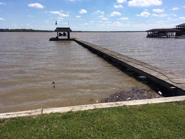
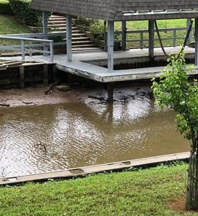
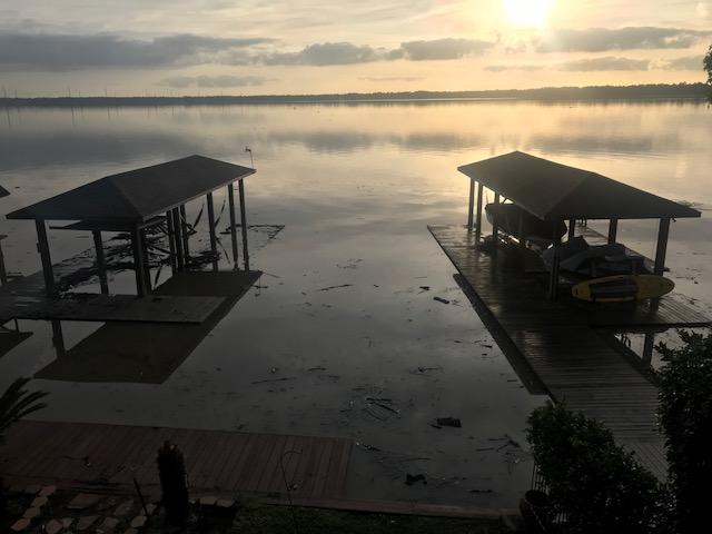
10 Before and After Lowering Lake Houston 2.5 feet
11 San Jacinto Watershed Sample Lake and River Conditions due to Rain on 3/27 & 3/28 Rain Amount 10:00 a.m. Thursday Level on Wed. Level on Mon. Has this tributary Crested? Lake Conroe ft 201 ft 201 ft n/a West Fork at US ft ft ft Predicted to Crest at 1:00 p.m. at 51.6 ft Spring Creek ft ft ft Predicted to Crest at 7:00 p.m. at 88.3 ft Cypress Creek ft ft ft Predicted to Crest at 1:00 P.M. at 79.2 ft Lake Houston ft ft ft n/a East Fork at New Caney ft ft ft Predicted to Crest at 4:00 a.m. Monday (4/2) at 61.2 ft Lake Livingston ft ft n/a n/a Rain Amount 5:00 p.m. Thursday Level on Wed. Level on Mon. Has this tributary Crested? Lake Conroe ft 201 ft 201 ft n/a West Fork at US ft ft ft Predicted to Crest at 10:00 p.m. at 51.9 ft Spring Creek ft ft ft Reached a high point of ft at 5:30 a.m. receding now but expected to rise again and crest at 85.6 ft Saturday afternoon. Cypress Creek ft ft ft Crested at and started Receding at 7:30 a.m. Lake Houston ft ft ft n/a East Fork at New Caney ft ft ft Rise in river has slowed considerably but it is still predicted to Crest at 4:00 a.m. Monday (4/2) at 61.2 ft Lake Livingston ft ft n/a n/a San Jacinto Watershed Sample Lake and River Conditions due to Rain on 3/27 & 3/28 Rain Amount 9:30 a.m. Friday Level on Thursday Level on Wed. Level on Mon. Has this tributary Crested? Lake Conroe ft ft 201 ft 201 ft n/a West Fork at US ft 51.6 ft ft ft Crested at ft 5:15 p.m. yesterday and river is receding now. Spring Creek ft ft ft ft Crested at ft at 5:30 a.m. yesterday river has continued to recede. Cypress Creek ft ft ft ft Crested at yesterday and has continued to recede. Lake Houston ft ft ft ft n/a East Fork at New Caney ft ft ft Rise in river is steady and predicted to Crest on Sunday at 7:00 p.m. at 61.6 ft Lake Livingston ft ft n/a n/a
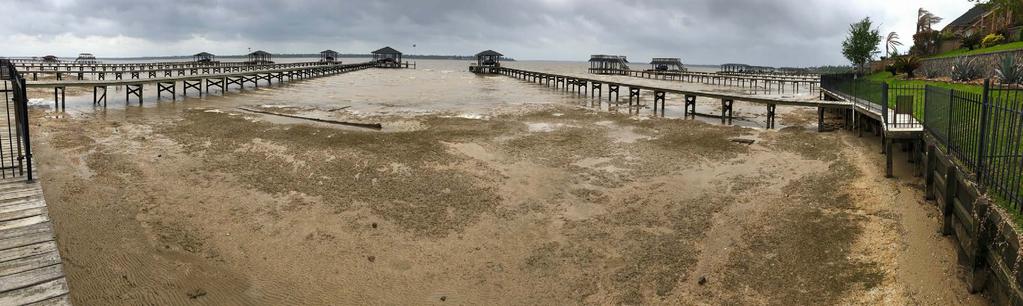
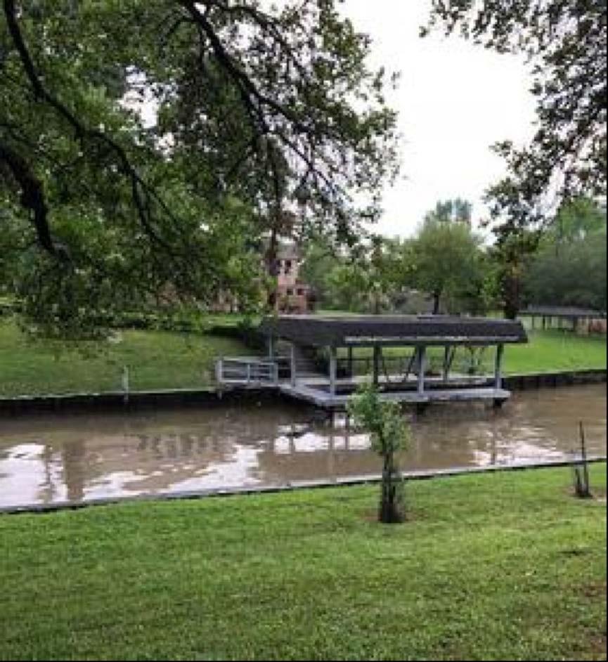
12 Atascocita Shores 3/29/2018 Atascocita Shores 3/28/2018
13


14 Road Impassable South of Hamblen Road Under IH69 Looking South Towards River à ß West Fork of the San Jacinto River Facing East towards IH69 Looking at Rail Road Tracks

15 3/28/2018 3/29/2018


16 Same address on the lake, one day apart in Walden on Lake Houston. 3/28/2018 3/29/2018

17 3/28/2018 3/29/2018


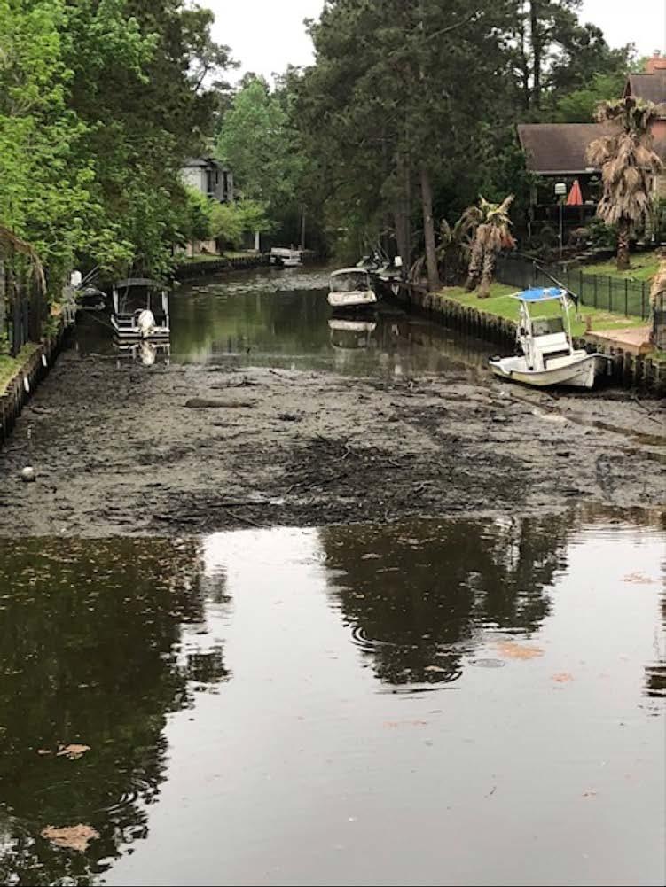
18 River Grove Park 3/29/2018 3/28/2018


19 River Grove Park Continued Post 3/28 Rain
USING A LABYRINTH WEIR TO INCREASE HYDRAULIC CAPACITY. Dustin Mortensen, P.E. 1 Jake Eckersley, P.E. 1
 USING A LABYRINTH WEIR TO INCREASE HYDRAULIC CAPACITY Dustin Mortensen, P.E. 1 Jake Eckersley, P.E. 1 Plum Creek Floodwater Retarding Structure No. 6 is located in an area of Kyle, Texas, that is currently
Town of Duck, North Carolina
 Tracking No. 00.00.2010 Erosion Mitigation And Shoreline Management Feasibility Study Town of Duck, North Carolina Coastal Planning & Engineering of North Carolina August 15, 2012 Tom Jarrett Robert Neal
MONTGOMERY COUNTY, TEXAS AND INCORPORATED AREAS VOLUME 2 OF 6
 MONTGOMERY COUNTY, TEXAS AND INCORPORATED AREAS VOLUME 2 OF 6 COMMUNITY NAME COMMUNITY NUMBER CONROE, CITY OF 480484 CUT AND SHOOT, CITY OF 481279 HOUSTON, CITY OF 480296 MAGNOLIA, CITY OF 481261 MONTGOMERY,
New Orleans Municipal Yacht Harbor
 New Orleans Municipal Yacht Harbor Marina Schematic Design Update 601 Poydras St., Suite 1860 New Orleans, LA, 70130 504-648-3560 Post-Katrina Municipal Yacht Harbor: Introduction The MYH was an approximate
Illinois State Water Survey
 Illinois State Water Survey HYDROLOGY DIVISION SWS Contract Report 508 COMPARISON OF 1987 AND 1989 BED PROFILE SURVEYS OF THE LOWER CACHE RIVER by Richard Allgire Office of Sediment and Wetland Studies
St. Johns River Water Supply Impact Study (WSIS)
") St. Johns River Water Supply Impact Study (WSIS) Michael G. Cullum, P.E. Chief, Bureau of Engineering & Hydro Science St. Johns River Water Management District The Water Supply Impact study is the most
St. Johns River Water Supply Impact Study (WSIS) Michael G. Cullum, P.E. Chief, Bureau of Engineering & Hydro Science St. Johns River Water Management District The Water Supply Impact study is the most
Houston HS Shoot-Out Schedule
 Pasadena Dobie HS - Court 1 9:00 AM High School Pool A Pasadena Crosby - 10:10 AM High School Pool A Killeen Pasadena - 11:20 AM High School Pool A Austin Anderson Cypress Creek - 12:30 PM High School
Boothbay Harbor Rotary Club May 12, 2016
 Mapping Potential Sea Level Rise and Storm Surge in Boothbay Harbor, ME Boothbay Harbor Rotary Club May 12, 2016 Peter A. Slovinsky, Marine Geologist Maine Geological Survey S.M. Dickson, MGS Quickly,
Sussex County, DE Preliminary Study Overview
 Sussex County, DE Preliminary Study Overview Coastal study scope: 102 miles of entire County shoreline Revised 102 panels for coastal study Riverine study scope: 14 streams, 67.1 miles, within the Nanticoke
SEA LEVEL RISE IMPACT ASSESSMENT AND MITIGATION ALTERNATIVES DEVELOPMENT FOR BALBOA ISLANDS, CITY OF NEWPORT BEACH, CALIFORNIA
 SEA LEVEL RISE IMPACT ASSESSMENT AND MITIGATION ALTERNATIVES DEVELOPMENT FOR BALBOA ISLANDS, CITY OF NEWPORT BEACH, CALIFORNIA Ying Poon 1, Brett Sanders 2, Randy Mason 3 and Robert Stein 4 The City of
Nome Harbor Page 2 of 12
 Nome Harbor Nome Harbor Page 2 of 12 Condition of Improvements 30 December 2015 Nome Harbor, Alaska (CWIS No. 010422, 012270, 072742, 087755) Authorization (1) Rivers and Harbors Act, 8 August 1917 (House
Summer Steelhead Surveys North Fork Trinity River Trinity County, California
 KRIS edition Summer Steelhead Surveys North Fork Trinity River Trinity County, California 1978-1997 By Loren Everest Fishery Biologist Weaverville Ranger District Shasta-Trinity National Forests October
Texas Department of Transportation s Gulf Intracoastal Waterway Capacity Study. GICA 112 th Annual Seminar July 28, 2017
 Texas Department of Transportation s Gulf Intracoastal Waterway Capacity Study GICA 112 th Annual Seminar July 28, 2017 Study Purpose Determine if current levels of vessel activity on the Texas segment
WEST WOODS GOLF CLUB COMMON RULES
 WEST WOODS GOLF CLUB COMMON RULES (Please refer to the USGA Rules of Golf, as well as the USGA Decisions on the Rules of Golf, for more detail.) RULE #27 BALL LOST OR OUT-OF-BOUNDS If a ball is lost outside
Assessment of Soil Erosion at a DC Park Facility Spring Valley Park NW Washington, DC
 Assessment of Soil Erosion at a DC Park Facility Spring Valley Park NW Washington, DC Annual Progress Report for FY 2004 Prepared by: Principal Investigators: Inder Bhambri, Ph.D., PE Philip Brach, Ph.D.,
San Antonio Creek Spreading Grounds Rehabilitation Project Ojai Valley, CA
 Ventura County Watershed Protection District San Antonio Creek Spreading Grounds Rehabilitation Project Ojai Valley, CA Presentation to Ventura River Watershed Council Project Funding Proposition 50 Integrated
APPENDIX D-2. Sea Level Rise Technical Memo
 APPENDIX D-2 Sea Level Rise Technical Memo 2185 N. California Blvd., Suite 500 Walnut Creek, CA 94596 (925) 944-5411 Fax: (925) 944-4732 www.moffattnichol.com DRAFT MEMORANDUM To: From: Neil Nichols,
Center Hill Lake as seen by the people who love it!
 CALENDAR 2017 Center Hill Lake as seen by the people who love it! ALL of the photos included in this year s calendar were taken by visitors to Center Hill Lake! Anyone and everyone was encouraged to enter
Shovelnose Creek Off-Channel Complex Berm Repair
 Shovelnose Creek Off-Channel Complex Berm Repair Recent high discharge events have put valuable off-channel salmonid rearing and spawning habitat at risk in the upper Squamish River. This document is a
SPO Regional Challenge Grant Creation of a Sea Level Adaption Working Group for Biddeford, Saco, OOB and Scarborough J.T. Lockman, AICP, Planning
 SPO Regional Challenge Grant Creation of a Sea Level Adaption Working Group for Biddeford, Saco, OOB and Scarborough J.T. Lockman, AICP, Planning Director Southern Maine Regional Planning Commission jlockman@smrpc.org
WELCOME. FM 2818 (Harvey Mitchell Parkway) Open House. Tuesday, Nov. 14, 2017
 Open House. Tuesday, Nov. 14, 2017") WELCOME FM 2818 (Harvey Mitchell Parkway) Open House Tuesday, Nov. 14, 2017 Why am I here? Review the planned improvements Provide comments on the proposed project The environmental review, consultation,
WELCOME FM 2818 (Harvey Mitchell Parkway) Open House Tuesday, Nov. 14, 2017 Why am I here? Review the planned improvements Provide comments on the proposed project The environmental review, consultation,
Town of Duck, North Carolina
 Tracking No. 00.00.2010 Erosion Mitigation And Shoreline Management Feasibility Study Town of Duck, North Carolina Coastal Planning & Engineering of North Carolina February 28, 2013 Ken Willson 1 Tracking
Total Suspended Solids, Stable Flow, and Wet Weather Event Monitoring in the Unnamed Tributary to the Grand River Watershed.
 Total Suspended Solids, Stable Flow, and Wet Weather Event Monitoring in the Unnamed Tributary to the Grand River Watershed December 2004 The Cadmus Group, Inc. Grand Valley State University Annis Water
1.Mill Creek Watershed Summary Description and Land Use
 1.Mill Creek Watershed Summary Description and Land Use Table xxx: Mill Creek Watershed Overview Watershed Size 31,435 acres/49.1 sq miles/ 127.1 sq km Elevation Range 5,594 feet [4,967-10,561] Stream
Fish Habitat Restoration and Monitoring in Southeast Washington. Andy Hill Eco Logical Research, Inc.
 Fish Habitat Restoration and Monitoring in Southeast Washington Andy Hill Eco Logical Research, Inc. Fish Habitat Restoration and Monitoring in Southeast Washington Talk overview: Restoration projects
Warden Tom Kasnick August 30, 1983
 scanned for KRIS Franz Creek Warden Tom Kasnick August 30, 1983 - Region 3 Franz Creek, Sonoma County - Fish Kill and Pollution Incident On August 3, 1983, you requested that I investigate a reported fish
GRAND RAPIDS RESTORATION GRAND RAPIDS REVITALIZATION
 GRAND RAPIDS RESTORATION RETURNING THE RAPIDS TO THE GRAND WHY IS THIS PLACE CALLED GRAND RAPIDS? We have been asking for over 100- years, where are the rapids? WHY IS THIS PLACE CALLED GRAND RAPIDS? compare
City of Del Mar Local Coastal Plan (LCP) Amendment for Sea Level Rise and Coastal Flooding
 Amendment for Sea Level Rise and Coastal Flooding") City of Del Mar Local Coastal Plan (LCP) Amendment for Sea Level Rise and Coastal Flooding 6/22/17 Presentation to Sea Level Rise Stakeholder- Technical Advisory Committee (STAC) Nick Garrity, P.E. Lindsey
City of Del Mar Local Coastal Plan (LCP) Amendment for Sea Level Rise and Coastal Flooding 6/22/17 Presentation to Sea Level Rise Stakeholder- Technical Advisory Committee (STAC) Nick Garrity, P.E. Lindsey
Technical Report Culvert A Hydraulic Analysis
 DATE: November 3, 2011 Technical Report Culvert A Hydraulic Analysis TO: FROM: RE: Jim Reiser, P.E. Project Manager Parsons Brinckerhoff, Inc. Kurt Killian, P.E., CFM Parsons Brinckerhoff, Inc. Design
Creek Trash Assessment (CTA) Methodology (Demonstration: Mill Run Creek, Cheltenham, Pa.)
 Methodology (Demonstration: Mill Run Creek, Cheltenham, Pa.)") Creek Trash Assessment (CTA) Methodology (Demonstration: Mill Run Creek, Cheltenham, Pa.) Mill Run Creek emerges from a storm sewer in Philadelphia to an open creek in Cheltenham. The Creek downstream
Creek Trash Assessment (CTA) Methodology (Demonstration: Mill Run Creek, Cheltenham, Pa.) Mill Run Creek emerges from a storm sewer in Philadelphia to an open creek in Cheltenham. The Creek downstream
CORPS FACTS. Harbor Dredging U.S. ARMY CORPS OF ENGINEERS BUILDING STRONG
 CORPS FACTS Harbor Dredging U.S. ARMY CORPS OF ENGINEERS BUILDING STRONG Disaster Response Sedimentation in the channel is caused by the normal cycle of silt movement, erosion from high water or heavy
Incorporating Geomorphic Processes and Sediment Dynamics into Salmonid Habitat Restoration Design
 Salmonid Restoration Federation 35 th Annual Salmonid Restoration Conference Davis, CA Incorporating Geomorphic Processes and Sediment Dynamics into Salmonid Habitat Restoration Design Concurrent Session:
1-32 NOME HARBOR, ALASKA (CWIS NOS , 87755, 12270, & 10422) Condition of Improvement 30 September 2012
 Condition of Improvement 30 September 2012") NOME HARBOR 1-32 NOME HARBOR, ALASKA (CWIS NOS. 72742, 87755, 12270, & 10422) Condition of Improvement 30 September 2012 AUTHORIZATION: (1) Rivers and Harbors Act, 8 August 1917 (House Doc. 1932, 64th
NOME HARBOR 1-32 NOME HARBOR, ALASKA (CWIS NOS. 72742, 87755, 12270, & 10422) Condition of Improvement 30 September 2012 AUTHORIZATION: (1) Rivers and Harbors Act, 8 August 1917 (House Doc. 1932, 64th
Information for File # SEW
 Information for File #2014-02744-SEW Applicant: Minnesota Department of Transportation (MnDOT), District 3; c/o Mr. Robert Nibbe Corps Contact: Sarah Wingert, U.S. Army Corps of Engineers, 180 5 th Street
Mr. Michael Malone CPS Energy 145 Navarro Street, Mail Drop San Antonio, Texas Project No
 October 17, 2016 Mr. Michael Malone CPS Energy 145 Navarro Street, Mail Drop 100406 San Antonio, Texas 78296 Project No. 0352436 Subject: Compilation of Construction History Calaveras Power Station San
SURGE SUPPRESSION ACHIEVED BY DIFFERENT COASTAL SPINE (IKE DIKE) ALIGNMENTS. Bruce A. Ebersole, Thomas W. Richardson and Robert W.
 ALIGNMENTS. Bruce A. Ebersole, Thomas W. Richardson and Robert W.") SURGE SUPPRESSION ACHIEVED BY DIFFERENT COASTAL SPINE (IKE DIKE) ALIGNMENTS Abstract Bruce A. Ebersole, Thomas W. Richardson and Robert W. Whalin, Jackson State University, Jackson, Mississippi The primary
SURGE SUPPRESSION ACHIEVED BY DIFFERENT COASTAL SPINE (IKE DIKE) ALIGNMENTS Abstract Bruce A. Ebersole, Thomas W. Richardson and Robert W. Whalin, Jackson State University, Jackson, Mississippi The primary
Emergency Action Plans for Dam Safety
 Emergency Action Plans for Dam Safety Introduction to the NC EAP template Tami Idol, EI Assistant State Dam Safety Engineer Reduce risk to loss of life Determine emergency level Make notifications for
Utilizing Vessel Based Mobile LiDAR & Bathymetry Survey Techniques for Survey of Four Southern California Breakwaters
 Utilizing Vessel Based Mobile LiDAR & Bathymetry Survey Techniques for Survey of Four Southern California Breakwaters Western Dredging Association: Pacific Chapter September 2012 Insert: Pipe Location
APPENDIX J HYDROLOGY AND WATER QUALITY
 APPENDIX J HYDROLOGY AND WATER QUALITY J-1 Technical Report on Airport Drainage, Northern Sector Airport and Ordinance Creek Watershed / Preliminary Creek Constructed Natural Channel Culvert J-2 Preliminary
Dam Breach Inundation Analysis
 Dam Breach Inundation Analysis Using HEC-RAS And GIS TWO CASE STUDIES IN BRITISH COLUMBIA, CANADA Canadian Dam Association 2014 Conference - Banff Alberta Presenters 2 Dwayne Meredith, P.Ag. KWL Vernon
DRAFT. October 17, 2014 File No Mr. Brendhan Zubricki Town Administrator Essex Town Hall 30 Martin Street Essex, MA.
 GZA GeoEnvironmental, Inc. Engineers and Scientists October 17, 2014 File No. 18.0171857.00 Mr. Brendhan Zubricki Town Administrator Essex Town Hall 30 Martin Street Essex, MA. 01929 DRAFT Re: Essex River
Total Suspended Solids, Stable Flow, and Wet Weather Event Monitoring in the Bass River Watershed. December The Cadmus Group, Inc.
 Total Suspended Solids, Stable Flow, and Wet Weather Event Monitoring in the Bass River Watershed December 2004 The Cadmus Group, Inc. Grand Valley State University Annis Water Resources Institute Submitted
Silverwood Plantation Roads & Drainage Project Plan 2017
 Project Name: Roads and Drainage Project Plan 2017 Roads & Drainage Committee Purpose Define all issues associated with Roads and Drainage in Silverwood Plantation. Generate solutions to address the issues
100 Most Congested Roadways in Texas
 100 Most Congested Roadways in Texas 2017 EXECUTIVE SUMMARY In response to increased roadway congestion throughout the state, in 2009 the Texas Legislature mandated that the Texas Department of Transportation
SSO 700 Integrated Watershed Action Plan: Continuous Calibration of a Model
 SSO 700 Integrated Watershed Action Plan: Continuous Calibration of a Model 5 Cities Plus August 16, 2017 Presented by Matt Spidare, P.E MSDGC Victoria Berry, P.E. CH2M Overview of Presentation Project
Saco River Maintenance Dredge PROJECT PLAN AND TIMELINE JUNE 15, 2017
 Saco River Maintenance Dredge 2017-2018 PROJECT PLAN AND TIMELINE JUNE 15, 2017 Overview Last dredged in 1994 Removing ~150,000 cy of sand and silt from the upper and lower reaches Disposal sites: In-River
TEXAS FLOODPLAIN MANAGEMENT ASSOCIATION. Poster by: Sydney 1st place grade 6-8
 TEXAS FLOODPLAIN MANAGEMENT ASSOCIATION 2014 CALENDAR Poster by: Sydney 1st place grade 6-8 Hey Kids STOP Meet TexAnna TADDpole. She is a very special taddpole. TexAnna is the Official Mascot of the TFMA's
Chadbourne Dam Repair and Fish Barrier
 Chadbourne Dam Repair and Fish Barrier Final Report for the Western Native Trout Initiative Prepared by: Carol Endicott Yellowstone Cutthroat Trout Conservation Biologist Montana Fish, Wildlife & Parks
HISTORY OF CONSTRUCTION
 HISTORY OF CONSTRUCTION CFR 257.73(c)(1) West Boiler Slag Pond Clifty Creek Plant Madison, Indiana October, 2016 Prepared for: Indiana Kentucky Electric Corporation Prepared by: American Electric Power
Public Notice. Corps File No. LRE Date: March 19, 2017 Expires: March 18, 2022
 US Army Corps of Engineers Detroit District Public Notice Corps File No. LRE-2016-00006-100 Date: March 19, 2017 Expires: March 18, 2022 PUBLIC NOTICE ANNOUNCING REGIONAL CONDITIONS AND WATER QUALITY CERTIFICATIONS
Multi-Jurisdictional Hazard Mitigation Plan
 Flooding General Flooding is the leading cause of death among all types of natural disasters throughout the United States, with its ability to roll boulders the size of cars, tear out trees, and destroy
100 Most Congested Roadways in Texas
 100 Most Congested Roadways in Texas 2018 Report EXECUTIVE SUMMARY In response to increased roadway congestion throughout the state, in 2009 the Texas Legislature mandated that the Texas Department of
Plan B Dam Breach Assessment
 Plan B Dam Breach Assessment Introduction In support of the Local Sponsor permit applications to the states of Minnesota and North Dakota, a dam breach analysis for the Plan B alignment of the Fargo-Moorhead
Casablanca Boulevard & GO Station Access
 Casablanca Boulevard & GO Station Access Class Environmental Assessment STAKEHOLDER WORKSHOP Thursday September 27th, 2018 5:30PM 8:00PM 1 WORKSHOP PURPOSE Provide an overview of the Design Alternatives
Abundance of Steelhead and Coho Salmon in the Lagunitas Creek Drainage, Marin County, California
 scanned for KRIS Abundance of Steelhead and Coho Salmon in the Lagunitas Creek Drainage, Marin County, California Prepared for: Marin Municipal Water District 220 Nellen Drive Corte Madera, California
Green CCR Surface Impoundment
 Green CCR Surface Impoundment Disposal of Coal Combustion Residuals (CCR) from Electric Utilities Final Rule CCR Impoundment 2017 Annual Inspection Report January 11, 2018 Prepared By: Project ID: 170138A
1-32 NOME HARBOR, ALASKA (CWIS NOS , 87755, & 10422) Condition of Improvement 30 September 2009
 Condition of Improvement 30 September 2009") NOME HARBOR 1-32 NOME HARBOR, ALASKA (CWIS NOS. 72742, 87755, & 10422) Condition of Improvement 30 September 2009 AUTHORIZATION: (1) Rivers and Harbors Act, 8 August 1917 (House Doc. 1932, 64th Congress,
NOME HARBOR 1-32 NOME HARBOR, ALASKA (CWIS NOS. 72742, 87755, & 10422) Condition of Improvement 30 September 2009 AUTHORIZATION: (1) Rivers and Harbors Act, 8 August 1917 (House Doc. 1932, 64th Congress,
Austin Avenue Bridges Project. Public Meeting Summary
 Austin Avenue Bridges Project Public Meeting Summary June 29, 2016 Red Table Safety and Connectivity Notes: 1. Would like to see forensic report evaluations 2. What is the lifespan? 3. Extend safety considerations
Small Footprint Topo-Bathymetric LiDAR
 May 8, 2013 Small Footprint Topo-Bathymetric LiDAR PNAMP Remote Sensing Forum Russ Faux, Co-CEO, WSI Amar Nayegandhi, Manager of Elevation Technologies, Dewberry Colin Cooper, Senior Analyst, WSI Watershed
Nearshore Placed Mound Physical Model Experiment
 Nearshore Placed Mound Physical Model Experiment PURPOSE: This technical note describes the migration and dispersion of a nearshore mound subjected to waves in a physical model. The summary includes recommendations
FY-16 Ongoing Contracts FY-16 Scheduled Contracts
 FY-16 Ongoing Contracts FY-16 Scheduled Contracts Christopher Frabotta Deputy Chief, Operations Division / Chief, Navigation Branch Southwestern Division - Galveston District 8 October 2015 Galveston District
Municipal Adaptation to Sea Level Rise in Saco Bay, Ogunquit, and Seabrook
 Municipal Adaptation to Sea Level Rise in Saco Bay, Ogunquit, and Seabrook Changing Environments Symposium Bowdoin College October 24, 2009 Climate Change Adaptation Panel 1:45 to 3:00 PM Jonathan T. Lockman,
PLEASE BE ADVISED THAT SOME OF THE INFORMATION IN THIS PRESENTATION IS OUTDATED SO IT IS ABLE TO SHOW CHANGES IN THE PLAN OVER TIME.
 1 PLEASE BE ADVISED THAT SOME OF THE INFORMATION IN THIS PRESENTATION IS OUTDATED SO IT IS ABLE TO SHOW CHANGES IN THE PLAN OVER TIME. - SANDRA GREEN, CITY SECRETARY FARMERSVILLE CITY COUNCIL MEETING February
Flood Insurance Study
 Flood Insurance Study Tulsa County, Oklahoma and Incorporated Areas VOLUME 5 of 7 COMMUNITY NAME COMMUNITY NO. Bixby, City of 400207 Broken Arrow, City of 400236 Collinsville, City of 400360 Glenpool,
Stony Creek Creel Census
 Stony Creek Creel Census conducted for Division of Fisheries Illinois Department of Conservation 600 North Grand Ave. West Springfield, IL 62706 by R. Weldon Larimore, Principal Investigator Jack A. Swanson,
Feasibility Study for Restoration of Titlow Lagoon Fish Passage. South Puget Sound Salmon Enhancement Group
 Feasibility Study for Restoration of Titlow Lagoon Fish Passage South Puget Sound Salmon Enhancement Group January 2010 Feasibility Study for Restoration of Titlow Lagoon Fish Passage Prepared for South
The Impact on Great South Bay of the Breach at Old Inlet Charles N. Flagg School of Marine and Atmospheric Sciences, Stony Brook University
 The Impact on Great South Bay of the Breach at Old Inlet Charles N. Flagg School of Marine and Atmospheric Sciences, Stony Brook University The previous report provided a detailed look at the conditions
INDIANA REGIONAL GENERAL CONDITIONS FOR THE STATE OF INDIANA
 INDIANA REGIONAL GENERAL CONDITIONS FOR THE STATE OF INDIANA These regional conditions are in addition to but do not supersede the requirements in the Federal Register (Volume 82 No. 4 of January 6, 2017).
Climate Change Impacts to KSC Launch Complex
 Climate Change Impacts to KSC Launch Complex Presented to: 2010 International Workshop on Environment and Energy By: John Shaffer NASA Environmental Management Branch Kennedy Space Center Hurricane Season
Bob Battalio, PE Chief Engineer, ESA September 8, 2016
 RELATING FUTURE COASTAL CONDITIONS TO EXISTING FEMA FLOOD HAZARD MAPS Technical Methods Manual Bob Battalio, PE Chief Engineer, ESA September 8, 2016 FMA 2016 Sacramento, California DWR-OST-SIO PILOTING
Flood Insurance Study
 Flood Insurance Study Tulsa County, Oklahoma and Incorporated Areas VOLUME 6 of 7 COMMUNITY NAME COMMUNITY NO. Bixby, City of 400207 Broken Arrow, City of 400236 Collinsville, City of 400360 Glenpool,
Chinook Salmon Spawning Study Russian River Fall 2005
 Chinook Salmon Spawning Study Russian River Fall 2005 Sonoma County Water Agency 2150 West College Avenue Santa Rosa, California 95401 Prepared by David Cook - Senior Environmental Specialist March 27,
OFFICE OF STRUCTURES MANUAL FOR HYDROLOGIC AND HYDRAULIC DESIGN CHAPTER 11 APPENDIX B TIDEROUT 2 USERS MANUAL
 OFFICE OF STRUCTURES MANUAL FOR HYDROLOGIC AND HYDRAULIC DESIGN CHAPTER 11 APPENDIX B TIDEROUT 2 USERS MANUAL APRIL 2011 APRIL 2011 Page 1 Preface TIDEROUT 2, Build 1.22 dated June 29, 2006 is the current
I-35 SMART WORK ZONE UPDATE
 I-35 SMART WORK ZONE UPDATE Larry Colclasure, P.E. TxDOT John Habermann, P.E., TTI 2014 Short Course Overview Current scope of I-35 Widening. (South of Salado to Hillsboro) TxDOT is committed to finishing
Developing Back Bay. Pre-Handout. Scope and Background
 Developing Back Bay Pre-Handout Scope and Background This is your third project and substantially different from the first two. It is actually a large scale planning project and as such, it is open ended.
Ellis Y. Byeon, PE Bryan VanderGheynst, PE 1
 Ellis Y. Byeon, PE Bryan VanderGheynst, PE 1 Background Information: City of Trenton, Mercer County Assunpink Creek, Pond Run and Delaware River Lower 2.5 miles of the Assunpink Creek Lower 0.6 miles of
Water Rescue
 3.5.3.2 Water Rescue YOUR ORGANIZATION STANDARD OPERATING PROCEDURES/GUIDELINES TITLE: Water Rescue NUMBER: 3.5.3.2 PREPARED BY: SECTION/TOPIC: Special Rescue Operations ISSUE DATE: REVISED DATE: APPROVED
Dare County Nourishment Project Town of Duck
 Dare County Nourishment Project Town of Duck Julien Devisse, P.E. and Ken Willson CB&I / Coastal Planning & Engineering of North Carolina, Inc. February 15, 2017 A World of Solutions Outline Background
2 nd Steelhead Summit. October 27 & 28, 2016 in San Luis Obispo, CA
 + 2 nd Steelhead Summit October 27 & 28, 2016 in San Luis Obispo, CA 1 + Session Overview Sponsors: California Trout City of San Luis Obispo Sustainable Conservation California Conservation Corps Cachuma
Culvert Design for Low and High Gradient Streams in the Midwest. Dale Higgins, Hydrologist Chequamegon-Nicolet National Forest
 Culvert Design for Low and High Gradient Streams in the Midwest Dale Higgins, Hydrologist Chequamegon-Nicolet National Forest Overview Culvert Design Considerations Hydraulic Terms Culvert Impacts Low
PROFILE OF SACRAMENTO RIVER, FREEPORT TO VERONA, CALIFORNIA,
 PROFILE OF SACRAMENTO RIVER, FREEPORT TO VERONA, CALIFORNIA, FLOOD OF FEBRUARY 1986 By J.C. Blodgett and J.B. Lucas U.S. GEOLOGICAL SURVEY Open-File Report 88-82 CO CM I m r-h CM Sacramento, California
STREAM SURVEY File form No..
 scanned for KRIS THE RESOURCES AGENCY OF CALIFORNIA California Department of Fish and Game STREAM SURVEY File form No.. Date: September 4, 1969. NAME: North Fork Schooner Gulch Creek COUNTY: Mendocino.
3. The qualification raised by the ISRP is addressed in #2 above and in the work area submittal and review by the ISRP as addressed in #1.
 Please find attached a response from The Confederated Tribes of the Warm Springs Reservation of Oregon (CTWSRO) for Project # 2008-301-00, Habitat Restoration Planning, Design and Implementation within
Minnesota Department of Natural Resources Division of Fish and Wildlife Section of Fisheries. Stream Survey Report. Luxemburg Creek.
 Minnesota F-29-R(P)-24 Area 315 Study 3 March 2016 Minnesota Department of Natural Resources Division of Fish and Wildlife Section of Fisheries Stream Survey Report Luxemburg Creek 2015 Mark Pelham Sauk
Welcome! Did You Know...? Aquatic Centre Dock Rebuild. Key Objectives
 1 Welcome! Aquatic Centre Dock Rebuild The City of Vancouver is improving the dock at the Vancouver Aquatic Centre, which is nearing the end of its service life and is in need of replacement. This creates
WMS 8.4 Tutorial Hydraulics and Floodplain Modeling HY-8 Modeling Wizard Learn how to model a culvert using HY-8 and WMS
 v. 8.4 WMS 8.4 Tutorial Hydraulics and Floodplain Modeling HY-8 Modeling Wizard Learn how to model a culvert using HY-8 and WMS Objectives Define a conceptual schematic of the roadway, invert, and downstream
JEFFERSON COUNTY, ARKANSAS AND INCORPORATED AREAS
 JEFFERSON COUNTY, ARKANSAS Community Name Community Number ALTHEIMER, CITY OF 050107 HUMPHREY, CITY OF 050108 JEFFERSON COUNTY 050440 (UNINCORPORATED AREAS) PINE BLUFF, CITY OF 050109 REDFIELD, CITY OF
Stormwater Level of Service Study - Phase 2 Flooding Adjacent to Rock Creek
 Stormwater Level of Service Study - Phase 2 Flooding Adjacent to Rock Creek City of Fairway, Kansas Fairway Stormwater Level of Service Study - Phase 2 Project No. 108200 Revision 1 12/6/2018 Stormwater
Hydraulic Modeling of Stream Enhancement Methods
 Hydraulic Modeling of Stream Enhancement Methods Matthew J. Curry John J. Levitsky Abstract Development within watersheds increases the amounts of runoff causing stream erosion and degradation of stream
COASTAL RAIL TRAIL ROSE CREEK BIKEWAY PROJECT COMMUNITY WORKSHOP #2 AUGUST 15, 2013
 COASTAL RAIL TRAIL ROSE CREEK BIKEWAY PROJECT COMMUNITY WORKSHOP #2 AUGUST 15, 2013 CHRIS CARTERETTE, AICP PROJECT MANAGER Chris.Carterette@sandag.org Direct: 619-699.7319 REGIONAL PLANNING BACKGROUND
Modeling Sediment Transport Along the Upper Texas Coast
 Modeling Sediment Transport Along the Upper Texas Coast David B. King Jr. Jeffery P. Waters William R. Curtis Highway 87 roadbed, Jefferson County Galveston District Corps Sabine Pass to San Luis Pass
APPENDIX C VEGETATED EMERGENCY SPILLWAY. VERSION 1.0 March 1, 2011
 APPENDIX C VEGETATED EMERGENCY SPILLWAY VERSION 1.0 March 1, 2011 [NOTE: Could use a better photo more clearly showing the emergency spillway in the context of the dam.] SECTION C-1: DESCRIPTION OF PRACTICE
Southwest Washington Littoral Drift Restoration Project: Design, Construction, and Monitoring
 Southwest Washington Littoral Drift Restoration Project: Design, Construction, and Monitoring J Jessica i St Stokke kk USACE Portland District October 28, 2010 WEDA Pacific Meeting Monterey, CA US Army
Readington Road (C.R. 637) Construction
 Construction") Public Information Meeting Thursday, August 2, 2012 Readington Road (C.R. 637) Construction from Dreahook Road to Harlan School Road Branchburg Township, Somerset County Readington Township, Hunterdon
Public Information Meeting Thursday, August 2, 2012 Readington Road (C.R. 637) Construction from Dreahook Road to Harlan School Road Branchburg Township, Somerset County Readington Township, Hunterdon
Please find attached the City Council's further submission on PC4 LWRP.
 From: To: Subject: Date: Attachments: Kingsbury, Peter Mailroom Mailbox PC4 plwrp Further Submission Tuesday, 17 November 2015 1:03:24 p.m. CCC further submission on ECan s LWRP PC4. Land and Water Regional
April 7, Prepared for: The Caribbean Disaster Emergency Response Agency Prepared by: CEAC Solutions Co. Ltd.
 April 7, 2006 Prepared for: The Caribbean Disaster Emergency Response Agency Prepared by: Introduction CEAC Solutions Co. Ltd was commissioned in May 2005 to prepare coastal beach erosion hazard maps for
SHORE PROTECTION AND HABITAT CREATION AT SHAMROCK ISLAND, TEXAS ABSTRACT
 SHORE PROTECTION AND HABITAT CREATION AT SHAMROCK ISLAND, TEXAS M. Cameron Perry, P.E., and Daniel J. Heilman, P.E. Coastal Engineer Shiner Moseley & Associates., Inc. 555 N. Carancahua Corpus Christi,
LAKE JESUP VEGETATION MAPPING: AN INTER-AGENCY COLLABORATION. Lakshmi Sankaran, GISP Public Works Department, Seminole County
 LAKE JESUP VEGETATION MAPPING: AN INTER-AGENCY COLLABORATION Lakshmi Sankaran, GISP Public Works Department, Seminole County LAKE JESUP Area - 12 sq miles Shoreline - 53 miles Watershed - 136 sq miles
TABLE OF CONTENTS LEGAL NOTICE
 Surface Impoundments Page No. i TABLE OF CONTENTS 1. INTRODUCTION... 1 2. PROPOSED CCR IMPOUNDMENT CLOSURE PROCEDURE... 3 3. PROPOSED COVER SYSTEM... 4 4. ESTIMATED MAXIMUM INVENTORY OF CCR... 4 5. ESTIMATED
East Downtown Tax Increment Reinvestment Zone (TIRZ) No. 15 Infrastructure Assessment Study
 No. 15 Infrastructure Assessment Study") East Downtown Tax Increment Reinvestment Zone (TIRZ) No. 15 Infrastructure Assessment Study Houston, TX Technical Memorandum April 15 th, 2009 Prepare by: 2950 North Loop West, Ste. 900 Houston, TX 77092
East Downtown Tax Increment Reinvestment Zone (TIRZ) No. 15 Infrastructure Assessment Study Houston, TX Technical Memorandum April 15 th, 2009 Prepare by: 2950 North Loop West, Ste. 900 Houston, TX 77092