$309,000 12,197 SF $25.33 PSF
|
|
|
- Rachel Phillips
- 5 years ago
- Views:
Transcription


1 COMMERCIAL LAND FOR SALE Davenport Street Omaha, NE $309,000 12,197 SF $25.33 PSF HIGHLIGHTS High visibility for retail store front with 22,000 VPD Outstanding frontage on Leavenworth Street Close proximity to Midtown Crossing and other area amenities Numerous redevelopment projects in the vicinity R8-ACI-1 (PL) Zoning Road Diet planned for 2020 AGENTS JOHN HEINE * * CERTIFIED * PROPERTY MANAGER *INDIVIDUAL MEMBERS Information presented is deemed reliable and is subject to change. Investors Realty, Inc. makes no warranties or guarantees regarding this information.

2 COMMERCIAL LAND FOR SALE 3612 Leavenworth Street Omaha, NE SITE DATA FINANCIAL DETAILS COVENANTS/RESTRICTIONS Area Zoning 12,197 SF Traffic Ct 22,000 Gas Water Electric R8-ACI-1 (PL) Yes Yes Yes Storm Sewer Street Curb Cuts Flood Plain Legal TBD No Coburns Subdivision Replat One Lot 2 Block 0 Lt 2 Easements Covenants Restrictions On Record On Record On Record $309,000 High visibility for store front retail with 22,000 VPD Outstanding frontage on Leavenworth Street Close proximity to Midtown Crossing and other area amenities Numerous redevelopment projects in the vicinity R8-ACI-1 (PL) Zoning Road Diet planned for 2020 PARCEL SIZE PRICE ,197 sf AGENTS John Heine


3 EXTENDED AERIAL DODGE STREET TURNER PARK FARNAM STREET HARNEY STREET 480 MUTUAL OF OMAHA DEWEY PARK 36TH STREET UNMC 42ND STREET DEWEY STREET JONES STREET LEAVENWORTH STREET MIDTOWN CROSSING D RN ER TU R VA LE U BO UE S RY A.M ST E SIT LEAVENWORTH PARK 12,720 SF EN AV


4 PROPERTY SITE 37TH STREET 37TH STREET RECENTLY CONSTRUCTED MULTIFAMILY 36TH STREET 36TH STREET 12,197 SF LEAVENWORTH STREET LEAVENWORTH STREET

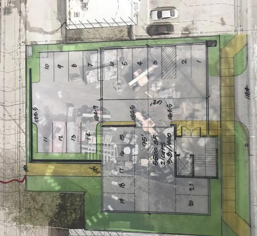
5 LEAVENWORTH STREET SITE PLAN

6 REDEVELOPMENT 2018T126 Leavenworth Street (31st Street to 39th Street) Council District: 3 Estimated Construction Year: 2020 Change from previous CIP: New Project This project improves the safety of all people moving through the Leavenworth Street corridor from 31st Street St. Marys Avenue to 39th Street and continues implementation of the first phase of the BIke Omaha network (aka the 20-Mile Loop ). The project includes resurfacing of the street with a four-to-three vehicle lane reconfiguration and the addition of bicycle lanes in both directions. The four-to-three conversion is a proven safety and efficiency improvement and is supported by a traffic study conducted in connection with Live Well Omaha. The project will support safe and comfortable active transportation through the provision of bicycle facilities and by reducing the barrier impact of Leavenworth Street to pedestrian travel, a concern voiced by area neighborhood associations. The project is also expected to boost economic development along the corridor. The Transportation Element of the Master Plan specifically identifies this stretch of Leavenworth street as a candidate for a four-to-three conversion and supports bicycle transportation. The MAPA Regional Bicycle and Pedestrian Plan calls for bicycle lanes on this stretch of Leavenworth, and the project is included in the Midtown Vision Total Estimated Total Cost Source of Funds 2016 Expenditure 2017 Appropriated Capital Budget Total FTB Source: City of Omaha Capital Improvement Program

7 DEMOGRAPHICS DEMOGRAPHICS 2022 DEMOGRAPHIC PROJECTION 2018 DEMOGRAPHIC PROFILE One-Mile Population Average Household Income Total Households Three-Mile Five-Mile 25, ,60 284,369 Population $48,846 $60,153 $60,256 Average Household Income 11,146 55, ,169 Total Households One-Mile Three-Mile Five-Mile 27, , ,527 $52,949 $66,982 $67,736 12,274 60, ,471
$ $ STREET
 LAND FOR SALE THE WOODLANDS 01 Davenport Street Omaha, NE 15 02.0.000 nd & Q Street Omaha, Nebraska $.50 - $1.50 psf NNN 0.1 Ac -.55 Ac Lot $.50psf. Ac Lot 5 $.50 psf 1.05 Ac SOLD Lot 0.1 Ac Lot 0.51 Ac
THE WOODLANDS. $ $12.00 psf NNN Ac Ac LAND FOR SALE S.192 ND STREET. 192nd & Q Street Omaha, Nebraska SOLD
 LAND FOR SALE THE WOODLANDS 01 Davenport Street Omaha, NE 15 02.0.000 nd & Q Street Omaha, Nebraska $.00 - $.00 psf NNN 0.1 Ac -.55 Ac SOLD Lot $.00 psf. Ac Lot 5 $.00 psf 1.05 Ac Lot 0.1 Ac Lot 0.51 Ac
NORTH PARK COMMONS. $ $14.50 psf NNN 1,436-3,311 sf COMMERCIAL FOR LEASE N. 120 th Street Omaha, Nebraska * * CERTIFIED *
 COMMERCIAL FOR LEASE ORTH PARK COMMOS 2101. 120 th Street Omaha, ebraska $12.50 - $14.50 psf 1,436-3,311 sf HIGHLIGHTS orth Park Office park has approximately 3,000 employees and 11,000 employees within
New Park Avenue Corridor West Hartford
 New Park Avenue Corridor West Hartford Current TOD Investment in the Corridor Mixed-use building currently under development by the Trout Brook Realty Advisors: a separate non-profit corporation, established
VALLEY VIEW BUSINESS PARK INDUSTRIAL 3859, 3863, 3867, 3871 Valley View Boulevard Las Vegas, NV 89103
 PROPERTY HIGHLIGHTS: ±855 - ±1,112 SF Suites available Lease rates: $0.89 - $1.33 SF/MG Zoning: M-1 (Light Manufacturing) All units have grade doors Project has excellent visibility and frontage along
This page intentionally left blank.
 This page intentionally left blank. COMMUNITY Glenpool Community Overview Glenpool Glenpool is a city of nearly 12,000 residents located in Tulsa County southwest of Tulsa and Jenks. The city is growing
Brooklyn Boulevard (County Road 152) Reconstruction Project Phase I. OPEN HOUSE June 20, 2017
 Reconstruction Project Phase I. OPEN HOUSE June 20, 2017") Brooklyn Boulevard (County Road 152) Reconstruction Project Phase I OPEN HOUSE June 20, 2017 Brooklyn Boulevard (County Road 152) Phase I Project Partners Project Lead Other Project Partners include Brooklyn
Brooklyn Boulevard (County Road 152) Reconstruction Project Phase I OPEN HOUSE June 20, 2017 Brooklyn Boulevard (County Road 152) Phase I Project Partners Project Lead Other Project Partners include Brooklyn
Rightsizing Streets: The Seattle Experience
 Rightsizing Streets: The Seattle Experience April 30, 2013 Brian Dougherty Seattle Department of Transportation Complete Streets 16% of households do not have a car Seniors Youth Transit riders Safety
4% CO-OP. SUNSET RIDGE PROFESSIONAL PLAZA 2920 North Green Valley Parkway Henderson, NV FOR LEASE PROPERTY HIGHLIGHTS:
 4% CO-OP PROPERTY HIGHLIGHTS: Professional office and medical suites in sizes ranging from ±1,013 - ±9,177 SF Lease rate: $0.70 PSF/NNN CAM s: $0.35 PSF Fully improved spec suites ready for occupancy American
CITY OF VAUGHAN EXTRACT FROM COUNCIL MEETING MINUTES OF OCTOBER 30, 2012
 CITY OF VAUGHAN EXTRACT FROM COUNCIL MEETING MINUTES OF OCTOBER 30, 2012 Item 31, Report No. 39, of the Committee of the Whole, which was adopted without amendment by the Council of the City of Vaughan
Bicycle Traffic Control Signal - St. Clair Avenue West and Poplar Plains Road
 PW17.11 REPORT FOR ACTION Bicycle Traffic Control Signal - St. Clair Avenue West and Poplar Plains Road Date: November 4, 2016 To: Public Works and Infrastructure Committee From: Acting General Manager,
INNER LOOP EAST. AIA Rochester Annual Meeting November 13, 2013 TRANSFORMATION PROJECT. Bret Garwood, NBD Erik Frisch, DES
 INNER LOOP EAST TRANSFORMATION PROJECT AIA Rochester Annual Meeting November 13, 2013 Bret Garwood, NBD Erik Frisch, DES Why? We are building a city that encourages walking, biking and enjoying the outdoor
City of Charlottesville Bicycle and Pedestrian Master Plan Update
 City of Charlottesville Bicycle and Pedestrian Master Plan Update September 17, 2014 I. Welcome and meeting overview II. Project status update III. Network overview IV. Break-out groups Pedestrian Network
COMPLETE STREETS A STEP FORWARD ITE District 10/FSITE Annual Meeting November 3, 2015
 COMPLETE STREETS A STEP FORWARD 2015 ITE District 10/FSITE Annual Meeting November 3, 2015 About Lakeland Incorporated: 1885 Population: 100,728 Area: Approx. 75 sq. mi Major Employers: Publix, Lakeland
MIXED-USE DEVELOPMENT OPPORTUNITY A CAPELLA COMMERCIAL EXCLUSIVE OFFERING
 MIXED-USE DEVELOPMENT OPPORTUNITY A CAPELLA COMMERCIAL EXCLUSIVE OFFERING The Village at Smithville is an exclusive mixed-use development offered by Capella Commercial, LLC located on Highway 71 in Smithville,
Engineering - Bicycle and Pedestrian
 Capital Improvement Plan Project Summary # Bikeways Program 781,000 860,000 900,000 933,000 933,000 933,000 # Cannonball Path 1,200,000-780,000 - - - # Capital City Trail - 70,000 - - 910,000 - # Goodman
Proposed. City of Grand Junction Complete Streets Policy. Exhibit 10
 Proposed City of Grand Junction Complete Streets Policy Exhibit 10 1 City of Grand Junction Complete Streets Policy Vision: The Complete Streets Vision is to develop a safe, efficient, and reliable travel
Bus Rapid Transit Plans
 Twin Cities Region Bus Rapid Transit Plans ULI Minnesota Workshop Connecting Bus Rapid Transit to the Community December 15, 2009 John Levin Director of Service Development Metro Transit Metropolitan Area
WELCOME. Thank you for joining us at the Second Public Workshop for the Carlsbad Pedestrian Master Plan. We look forward to receiving your feedback.
 City of Carlsbad Pedestrian Master Plan: WELCOME WELCOME Please Sign In Provide Input at Flip Charts Review Boards Presentation of Draft Plan Thank you for joining us at the Second Public Workshop for
Crystal City Citizen Review Council Meeting. July 10, 2013
 Crystal City Citizen Review Council Meeting July 10, 2013 Topics to be covered Overview of Crystal City Transportation Projects Capital Program Investments Regional Coordination 9 Program Overview Crystal
City of Temecula Capital Improvement Program FY CMAA Inland Empire Cities Update October 24, 2018
 City of Temecula Capital Improvement Program FY 2018-23 CMAA Inland Empire Cities Update October 24, 2018 Introduction City Profile Population: 113,181 (up 1.9% from 2017) Median Age: Number of Households:
MONTGOMERY COUNTY COUNCIL MEMORANDUM
 MONTGOMERY COUNTY COUNCIL R O C K V I L L E, M A R Y L A N D HANS RIEMER COUNCILMEMBER AT-LARGE MEMORANDUM To: T&E Committee From: Councilmember Hans Riemer Date: March 1, 2016 Re: Funding a Protected
Rail Station Fact Sheet University of Dallas Station
 Rail Station Fact Sheet University of Dallas Station Station Overview University of Dallas Station is located on John Carpenter Freeway and west of Loop 12 across from the University of Dallas in Irving.
Project Goal and Description. Why Broadway? Broadway SFMTA.COM/BROADWAY. The goal of the Broadway Safety Improvement
 PROJECT OVERVIEW Project Goal and Description The goal of the Broadway Safety Improvement d St Van Ness Ave Project is to improve safety and comfort for all who Franklin St Hyde St Octavia St Gough St
RETAIL BUILDING AT NW 36TH STREET
 RETAIL BUILDING AT 59-85 NW 36TH STREET Investment Opportunity Design District Miami Exclusively Offered by RKF INVESTMENT SALES & ADVISORY SERVICES Table of Contents Executive Summary 3 Investment Highlights
FOR LEASE SHORT TERM OFFICE AND RETAIL LEASE OPPORTUNITIES IN OAKRIDGE
 FOR LEASE SHORT TERM OFFICE AND RETAIL LEASE OPPORTUNITIES IN OAKRIDGE KITSILANO DOWNTOWN VANCOUVER Vancouver General Hospital Vancouver City Hall SHAUGHNESSY BC Children's Hospital/ BC Women's Hospital
Hennepin County Bicycle and Pedestrian Planning
 Hennepin County Bicycle and Pedestrian Planning 1 Value of bicycle and sidewalk systems Safety Livability Mobility Health Personal Finances Economic Sustainability Clean Air Recreation Parking and congestion
2018 Transportation Alternatives Program (TAP) Application Presentation to Palm Beach TPA BRANT BRIDGE CONNECTION LOOP EXTENSION ON CARL BOLTER DR
 Application Presentation to Palm Beach TPA BRANT BRIDGE CONNECTION LOOP EXTENSION ON CARL BOLTER DR") 2018 Transportation Alternatives Program (TAP) Application Presentation to Palm Beach TPA BRANT BRIDGE CONNECTION LOOP EXTENSION ON CARL BOLTER DR Project Location N N Connecting South Delray Beach Existing
2018 Transportation Alternatives Program (TAP) Application Presentation to Palm Beach TPA BRANT BRIDGE CONNECTION LOOP EXTENSION ON CARL BOLTER DR Project Location N N Connecting South Delray Beach Existing
El Camino Real Specific Plan. TAC/CAC Meeting #2 Aug 1, 2018
 El Camino Real Specific Plan TAC/CAC Meeting #2 Aug 1, 2018 Land Use Alternatives Goals and Tradeoffs Parks & open space Housing Retail & services Civic spaces Parking Community gathering spaces 3 Alternatives
Improving intersections for people that walk in Minneapolis
 Matthew Dyrdahl, AICP, LCI Bicycle and Pedestrian Coordinator Minneapolis Public Works CITY OF MINNEAPOLIS Improving intersections for people that walk in Minneapolis Transportation Bonanza February 8,
Public Works and Infrastructure Committee. General Manager, Transportation Services
 STAFF REPORT ACTION REQUIRED Extending the Bay Street Bicycle Lanes Date: May 16, 2013 To: From: Public Works and Infrastructure Committee General Manager, Transportation Services Wards: Toronto Centre
BALBOA AREA: TRANSPORTATION PROJECTS & PLANNING
 BALBOA AREA: TRANSPORTATION PROJECTS & PLANNING TRANSPORTATION FOR ALL AGES, ABILITIES & MEANS CHANGING PATTERNS: TRENDING TO WALKING, BIKING, TRANSIT San Francisco s Change in Number of Commuters by Mode
About the Wilmington Downtown Circulation Study
 About the Wilmington Downtown Circulation Study Part of the Wilmington i Initiatives partnership Wilmington Area Planning Council City of Wilmington Delaware Department of Transportation Delaware Transit
SAFE ROUTES TO SCHOOL (SR2S)
") SAFE ROUTES TO SCHOOL (SR2S) In partnership with Burbank Unified School District (BUSD) & City of Burbank George Washington Elementary School Thomas Jefferson Elementary School John Muir Middle School
SAFE ROUTES TO SCHOOL (SR2S) In partnership with Burbank Unified School District (BUSD) & City of Burbank George Washington Elementary School Thomas Jefferson Elementary School John Muir Middle School
Polk Streetscape Project
 What is this project? The Polk Streetscape Project is an effort to improve safety for everyone traveling on Polk Street between Union and McAllister streets. Also included in this project are paving, sewer
Route 79/Davol Street Corridor Study
 Route 79/Davol Street Corridor Study Fall River, MA Public Information Meeting #2 November 21, 2013 Fall River Heritage State Park Fall River, MA Agenda Welcome and Introductions Overview of Study Process
RICE DRIER BUSINESS PARK WEST SIDE OF MAIN ST, BETWEEN MCHARD & ORANGE 1784 N MAIN ST, PEARLAND, TEXAS 77581
 PROPERTY INFORMATION: - 32,900 SF Available for Lease WEST SIDE OF MAIN ST, BETWEEN MCHARD & ORANGE 4 Acres Available Across the street from Walmart Supercenter and Chase Bank Next door to Pearland Education
Vision: Traditional hamlet with an attractive business/pedestrian friendly main street connected to adjacent walkable neighborhoods
 N D. Focus Area II Vision: Traditional hamlet with an attractive business/pedestrian friendly main street connected to adjacent walkable neighborhoods Transit Road Focus Area II is located in the Hamlet
4. Action Plan & Projects
 4. Action Plan & Projects 45 46 ACTION PLAN AND PROJECTS The Action Plan organizes the list of transportation projects described in the Mobility Framework Plan section into short-term (0-5 years) and long-term
Public Meeting #1 January 30, 2018
 Public Meeting #1 January 30, 2018 Meeting Outline Mayor s Introduction Presentation Q&A Group Activities Wrap-up Presentation Outline Introduction Existing Conditions Market Assessment Break-out Setup
A copy of the draft plan is available at:
 To: From: Re: Mayor and City Council Patricia Nilsson, AICP, Comprehensive Planning Manager Boise Central Bench Neighborhood Pedestrian and Bicycle Plan Date: August 24, 2012 Requested Action Provide comments
Bay to Bay Boulevard Complete Streets Project
 Bay to Bay Boulevard Complete Streets Project Dale Mabry Highway to Bayshore Boulevard February 08, 2018 Photo Source: Tampa Bay Times Alessandra Da Pra Meeting Format Introduction Resurfacing Information
Table #6 VISION CHARACTERISTICS
 Table #6 VISION White Flint is a place to live, work, play, shop, and walk with sufficient density to encourage quality redevelopment. Vibrant streets and consistent streetscapes are important. CHARACTERISTICS
Mumford Terminal Replacement Opportunities Neighbourhood Open House. we are here. PHASE 2 Identifying and Evaluating Candidate Sites
 Welcome Replacement Opportunities Neighbourhood Open House. AGENDA PURPOSE 1. REVIEW the information boards 2. DISCUSS aspects of the project with the project team 3. SHARE your thoughts on replacement
» Draft Recommendations» Discussion» Next Steps. Plan for Walking and Biking
 SAC Meeting Plan #3 for September Walking and 12, Biking 2018 » Draft Recommendations» Discussion» Next Steps Plan for Walking and Biking » Stakeholder and Public Outreach» Background data collection and
Saskatchewan Drive Roadway Rehabilitation and Shared-Use Path Widening
 Saskatchewan Drive Roadway Rehabilitation and Shared-Use Path Widening We are here today to present the draft plan for the Saskatchewan Drive Roadway Rehabilitation and Shared-Use Path Widening project
Summary: Mercer County Princeton Avenue & Spruce Street Study January 2009
 Summary: Several recent studies have assessed potential development and redevelopment opportunities in the Mercer Crossing area of Trenton, Ewing, and Lawrence. This Princeton Avenue and Spruce Street
San Jose Transportation Policy
 San Jose Transportation Policy Protected Intersections in LOS Policies to Support Smart Growth Presented by: Manuel Pineda City of San Jose Department of Transportation Bay Area Map San Francisco Oakland
5 CIRCULATION AND STREET DESIGN
 5 CIRCULATION AND STREET DESIGN This chapter describes circulation and streetscape improvements proposed for the Northwest Chico Specific Plan Area. It includes detailed design specifications for existing
PHILADELPHIA RESIDENTIAL DEVELOPMENT OPPORTUNITY Gray s Ferry Philadelphia, PA.
 PHILADELPHIA RESIDENTIAL DEVELOPMENT OPPORTUNITY Gray s Ferry Philadelphia, PA. Cumulative Land Area: 1.5+/- Acres or 66,867+/- SF Gray s Ferry Ave S. 32nd. Street S. Patton Street S. Napa Street S. 31st.
Toronto and East York Community Council. Director, Transportation Services, Toronto and East York District
 No Turn on Red Regulations STAFF REPORT ACTION REQUIRED Date: June 1, 2010 To: From: Toronto and East York Community Council Director, Transportation Services, Toronto and East York District Wards: Trinity
Nantasket Beach Two-Way Conversion and HRA Land Transfer. Board of Selectmen Meeting May 31, 2018
 Nantasket Beach Two-Way Conversion and HRA Land Transfer Board of Selectmen Meeting May 31, 2018 Public Meetings 2015/2016 STUDY PHASE 4 public listening sessions and presentations 2017 PRELIMINARY DESIGN
Typical Rush Hour Commute. PennyforTransportation.com
 Typical Rush Hour Commute In the News Overview of the Plan Collaborative plan with projects in every community Prioritizing connectivity and congestion relief Dedicated transportation-specific funding;
City of Gainesville Transportation/Roadway Needs PROJECT SUMMARY
 A1 Roadway Resurfacing $23,846,000 TYPE: Preservation of existing system Roadway resurfacing A2 Signal Replacement $6,000,000 TYPE: Preservation of existing system Replace traffic signals. B1 W 6th St
Draft MOBILITY ELEMENET. Community Meeting May 22, 2013
 Draft MOBILITY ELEMENET Community Meeting May 22, 2013 Agenda Presentation Ira Brown New Mobility Paradigm Movement of People Implementation Q&A Ira Brown and Dave Roseman Small Group Discussion at Each
Clackamas County Comprehensive Plan
 ROADWAYS The County s road system permits the movement of goods and people between communities and regions, using any of a variety of modes of travel. Roads provide access to virtually all property. They
Presentation of Staff Draft March 18, 2013 COUNTYWIDE TRANSIT CORRIDORS FUNCTIONAL MASTER PLAN
 Presentation of Staff Draft March 18, 2013 COUNTYWIDE TRANSIT CORRIDORS FUNCTIONAL MASTER PLAN Public Outreach Fall 2011: Two community meetings/open houses Fall 2012: Three community meetings/open houses
This page intentionally left blank.
 This page intentionally left blank. COMMUNITY Coweta Community Overview Coweta Coweta, a residential community located in Wagoner County, is a suburb of Tulsa situated southeast of the metropolitan area
REGIONAL BICYCLE AND PEDESTRIAN DESIGN GUIDELINES
 REGIONAL BICYCLE AND PEDESTRIAN DESIGN GUIDELINES November 16, 2011 Deb Humphreys North Central Texas Council of Governments Bicycle and Pedestrian Advisory Committee Snapshot of the Guide 1. Introduction
Topics To Be Covered. Summarize Tier 2 Council Direction Discuss Mill and Ash Alternatives Next Steps
 Topics To Be Covered Summarize Tier 2 Council Direction Discuss Mill and Ash Alternatives Next Steps Tier 2 Council Direction Dismiss Bus Rapid Transit along the Union Pacific Railroad Dismiss Bus Rapid
Houston-Galveston Area Council
 Houston-Galveston Area Council Pedestrian and Bicycle Special Districts Study Phase One Findings Pro Walk/Pro Bike Conference September 9, 2004 in association with Gulf Coast Institute Euclid Studio Lorin
City of Memphis On-Street Parking Modification Guidelines
 City of Memphis Effective Date: December 1, 2013 Bicycle/Pedestrian Program 125 N. Main Street Memphis, TN 38103 (901) 576-6710 www.bikepedmemphis.com City of Memphis Executive Summary It is current practice
Dr. M.L. King, Jr. Street North Complete Streets Resurfacing Opportunities HOUSING, LAND USE, AND TRANSPORTATION COMMITTEE MARCH 22, 2018
 Dr. M.L. King, Jr. Street North Complete Streets Resurfacing Opportunities HOUSING, LAND USE, AND TRANSPORTATION COMMITTEE MARCH 22, 2018 What s Happening The City plans to mill and resurface Dr. M.L.
Bicycle Transportation Budget Plan: Lawrence, KS
 Bicycle Transportation Budget Plan: Lawrence, KS Bicycle Objectives Lawrence Planning Documents Establish a dedicated funding plan to complete the implementation of a bikeway system plan, and for maintenance
Richmond-Adelaide Cycle Tracks
 Public Drop-In Event Richmond-Adelaide Cycle Tracks June 25, 2018 12:00 p.m. 3:00 p.m. 4:30 p.m. 7:30 p.m. Metro Hall, Rotunda 55 John Street 1 Purpose of Event In Scope Communicate an update about the
CLOSED. The draft concept design has been broken down into 5 categories for the purpose of this survey:
 Old Strathcona s neighbourhood renewal process is now at the draft concept design phase. Over the last several months, the city has been gathering local knowledge and resident input that has been used
Corpus Christi Metropolitan Transportation Plan Fiscal Year Introduction:
 Introduction: The Safe, Accountable, Flexible, Efficient Transportation Equity Act: A Legacy for Users (SAFETEA-LU) has continued the efforts started through the Intermodal Surface Transportation Efficiency
Ocean Lakes Village. Redevelopment of the Northwest Corner of Highway 544 & Highway 17 Business Myrtle Beach, South Carolina PREPARED BY:
 Ocean Lakes Village Redevelopment of the Northwest Corner of Highway 544 & Highway 17 Business Myrtle Beach, South Carolina 29575 PREPARED BY: ROX POLLARD 803 401 4242 rox.pollard@colliers.com TAYLOR WOLFE
7.04 AC OF LAND VETERANS MEMORIAL HIGHWAY
 7.04 AC OF LAND VETERANS MEMORIAL HIGHWAY 1080 VETERANS MEMORIAL DRIVE MABLETON, GA 30126 Derek Creviston Advisor 770.992.5112 x230 dcreviston@svn.com SVN CREVISTON REALTY, INC. 10929 CRABAPPLE ROAD, SUITE
This page intentionally left blank.
 This page intentionally left blank. Community Plan Skiatook Community Overview Skiatook Skiatook is a growing city located approximately 14 miles north of downtown Tulsa with its main street, W.C. Rogers
Westgate/Belvedere Homes Community Redevelopment Agency. Belvedere Heights. Streetlights & Sidewalks Improvements Project.
 Westgate/Belvedere Homes Community Redevelopment Agency Belvedere Heights Streetlights & Sidewalks Improvements Project Phase II TPA 2018 Transportation Alternatives Program (TAP) BTPAC Presentation Thursday,
ACTIVE TRANSPORTATION
 ACTIVE TRANSPORTATION Mobility 2040 Supported Goals Improve the availability of transportation options for people and goods. Support travel efficiency measures and system enhancements targeted at congestion
TOWN OF WILLIAMSTON, SC BICYCLE AND PEDESTRIAN MASTER PLAN TOWN OF WILLIAMSTON, SC BICYCLE AND PEDESTRIAN MASTER PLAN
 TOWN OF WILLIAMSTON, SC BICYCLE AND PEDESTRIAN MASTER PLAN Americans Want Choices 55% of Americans would rather drive less & walk more. Transit use is growing faster than population or highway travel.
George Washington Memorial Hwy. Jeff Parker, CCIM Senior Vice President
 Major upgrades to the property! George Washington Memorial Hwy York River Crossing CONTACT US: Ned Brooks Senior Vice President +1 757 228 1829 ned.brooks@cbre-norfolk.com Jeff Parker, CCIM Senior Vice
CITY OF HAMILTON PLANNING AND ECONOMIC DEVELOPMENT DEPARTMENT Transportation Planning and Parking Division
 CITY OF HAMILTON PLANNING AND ECONOMIC DEVELOPMENT DEPARTMENT Transportation Planning and Parking Division TO: Chair and Members Public Works Committee COMMITTEE DATE: June 18, 2018 SUBJECT/REPORT NO:
Chapter 4: Funding and Implementation
 Chapter 4: Funding and Implementation 83 84 Cost Estimating Cost estimating is an iterative process. When a project is in the conceptual stage, preliminary cost estimates are also provided conceptually,
Active Transportation Infrastructure Investment A Business Case
 Active Transportation Infrastructure Investment A Business Case In 2016, the Real Estate Foundation awarded the Capital Regional District a $50,000 grant for Shifting Gears: Land Use Change through Active
EPC SouthTrail Plaza 4420 Calgary Trail NW, Edmonton, Alberta
 FOR LEASE EPC SouthTrail Plaza 4420 Calgary Trail NW, Edmonton, Alberta PROPOSED - 6,625 SF +/- New Building at Fully Leased Mill Creek Centre New High Exposure Retail and Professional Development 56,309
Purpose + Need. Connect: Thrive: Develop: < Strengthen the spine of our regional transportation system
 Purpose + Need I-29 NW Barry Road 64/68/72 MAIN STREET Connect: < Strengthen the spine of our regional transportation system Leavenworth Road Parallel Parkway State Avenue 18th Street Expressway Shawnee
Complete Streets Policy Framework
 Complete Streets Policy Framework City of Vancouver Complete Streets Planning 2017 Complete Streets Recommendations: Council receive for information the Citywide Complete Streets policy framework Council
Metro Nashville Sidewalk Requirements. Section (Provision of sidewalks) Effective July 1, 2017
 Effective July 1, 2017") Metro Nashville Sidewalk Requirements Section 17.20.120 (Provision of sidewalks) Effective July 1, 2017 Why are sidewalks a critical priority? Lack of requirements from 1950s to 1990s NashvilleNext, nmotion,
Metro Nashville Sidewalk Requirements Section 17.20.120 (Provision of sidewalks) Effective July 1, 2017 Why are sidewalks a critical priority? Lack of requirements from 1950s to 1990s NashvilleNext, nmotion,
Goodlettsville Bicycle and Pedestrian Plan Executive Summary
 Goodlettsville Bicycle and Pedestrian Plan July 2010 In Cooperation with the Nashville Area Metropolitan Planning Executive Organization Summary Introduction Progressive and forward thinking communities
Board of Supervisors February 27, 2017
 : Traffic Analysis Results & Draft Conceptual Plan Board of Supervisors February 27, 2017 Transportation Solutions Building Better Communities Presentation Overview Background Summary of Traffic Analysis
CITY OF BLOOMINGTON COMPLETE STREETS POLICY
 CITY OF BLOOMINGTON COMPLETE STREETS POLICY POLICY OBJECTIVE: The City of Bloomington will enhance safety, mobility, accessibility and convenience for transportation network users of all ages and abilities,
EPC SouthTrail Plaza NW Corner of Whitemud Drive and Calgary Trail
 FOR LEASE EPC SouthTrail Plaza NW Corner of Whitemud Drive and Calgary Trail PROPOSED - 6,625 SF +/- New Building at Fully Leased Mill Creek Centre New High Exposure Retail and Professional Development
43 rd Avenue, Skillman Avenue Protected Bike Lanes
 43 rd Avenue, Skillman Avenue Protected Bike Lanes Presented to Queens Community Board 2 Transportation Committee - November 6, 2017 43 rd Avenue, Skillman Avenue: Presentation Overview Background Project
Joshua Saak, P.E., PTOE Traffic Design Engineer Ada County Highway District May 23, 2013
 Joshua Saak, P.E., PTOE Traffic Design Engineer Ada County Highway District May 23, 2013 Creating Great Streets Through Road Diets and Conversions The Charlotte Experience Topics to Discuss Charlotte s
City of Madison: 2017 Capital Budget Capital Improvement Plan
 Capital Improvement Plan Project Summary Bikeways Program 779,000 751,000 630,000 670,000 703,000 703,000 Cannonball Path 210,000 - - 730,000 - - Cap City Trail 1,140,000-360,000 - - 910,000 Ice Age Junction
Traffic Improvements for the Transit Oriented Development District (TODD) Meriden Public Library March 11, 2014
 Meriden Public Library March 11, 2014") Traffic Improvements for the Transit Oriented Development District (TODD) Meriden Public Library March 11, 2014 Project Overview Coordinate roadway improvements with other major projects HUB Flood Control
Traffic Improvements for the Transit Oriented Development District (TODD) Meriden Public Library March 11, 2014 Project Overview Coordinate roadway improvements with other major projects HUB Flood Control
FEASIBILITY STUDY MACARTHUR BOULEVARD
 FEASIBILITY STUDY MACARTHUR BOULEVARD Wabash Avenue to South Grand Avenue Springfield, IL SANGAMON COUNTY TABLE OF CONTENTS 1.0 DESCRIPTION & PURPOSE AND NEED OF STUDY... 1 2.0 EXISTING CONDITIONS... 2
Palou Complete Street Project Barneveld Avenue to Crisp Road Project overview and concept design Community Meeting #2 May 13, 2015
 Palou Complete Street Project Barneveld Avenue to Crisp Road Project overview and concept design Community Meeting #2 May 13, 2015 Agenda Welcome and introductions Project overview, history and goals Concept
TOWN OF PORTLAND, CONNECTICUT COMPLETE STREETS POLICY
 TOWN OF PORTLAND, CONNECTICUT COMPLETE STREETS POLICY I. VISION, GOALS & PRINCIPLES VISION To improve the streets of Portland making them safer and more accessible for all users including pedestrians,
Hennepin County Pedestrian Plan Public Comment Report
 Hennepin County Pedestrian Plan Public Comment Report On May 31, 2013, the draft Hennepin County Pedestrian Plan was released for a 45-day public comment period ending July 15, 2013. The county received
TULSA CITY COUNCIL CAPITAL IMPROVEMENT PROGRAM TASK FORCE MEETING JANUARY
 CITY OF TULSA BICYCLE & PEDESTRIAN INFRASTRUCTURE TULSA CITY COUNCIL CAPITAL IMPROVEMENT PROGRAM TASK FORCE MEETING JANUARY 31, 2013 CITY OF TULSA ENGINEERING SERVICES DEPARTMENT CITY OF TULSA ADA TRANSITION
95 th Street Corridor Transportation Plan. Steering Committee Meeting
 95 th Street Corridor Transportation Plan Steering Committee Meeting August 11, 2014 PROJECT OBJECTIVES Develop a Transportation and Economic Plan for the 95 th Street Corridor Improve public transit efficiency
3105 Alderwood Mall Blvd, Lynnwood, WA FOR SALE PAUL SLEETH th Street SW. Alderwood Mall Parkway
 3105 Alderwood Mall Blvd, Lynnwood, WA 98036 196th Street SW Alderwood Mall Alderwood Mall Parkway FOR SALE PAUL SLEETH 206.518.9547 paul.sleeth@ngkf.com BILLY SLEETH 206.518.9567 billy.sleeth@ngkf.com
Ocean Lakes Village. Redevelopment of the Northwest Corner of Highway 544 & Highway 17 Business Myrtle Beach, South Carolina 29575
 Ocean Lakes Village Redevelopment of the Northwest Corner of Highway 544 & Highway 17 Business Myrtle Beach, South Carolina 29575 PREPARED BY: Rox Pollard 803 401 4242 rox.pollard@colliers.com Taylor Wolfe
Safety & Convenience for All Users, in All Modes. Barbara McCann NCSL December 3, 2013
 Safety & Convenience for All Users, in All Modes Barbara McCann NCSL December 3, 2013 Safety & Convenience for All Users? Who was left out when this road was planned? Takaaki Iwabu for Raleigh News Observer
CITY OF CAMBRIDGE 2015 BICYCLE PLAN TOWARDS A BIKABLE FUTURE
 CITY OF CAMBRIDGE 2015 BICYCLE PLAN TOWARDS A BIKABLE FUTURE WHICH FUTURE? CAMBRIDGE MUNICIPAL POLICIES 1992: Vehicle Trip Reduction Ordinance 1998: Parking & Transportation Demand Ordinance 2002: Climate
Stakeholder Update. Agenda. Project update Needs Identification Strategy Proposed needs Safety Collectors/Arterials Greenways Local roads
 1 Stakeholder Update May 21, 2018 2 Agenda Project update Needs Identification Strategy Proposed needs Safety Collectors/Arterials Greenways Local roads Proposed Evaluation Criteria Next Steps 1 Project/Schedule