STOP! Town Hall Mee/ng Sarasota, The Vue, and You September 22, 2016 How Sarasota can have wide sidewalks.
|
|
|
- Lester Tyler
- 5 years ago
- Views:
Transcription
1 STOP! Town Hall Mee/ng Sarasota, The Vue, and You September 22, 2016 How Sarasota can have wide sidewalks. By Mike Lasché, MPPM Bicycle/Pedestrian Advocates Florida Walks and Bikes
2 A few words about me 1985, New College thesis on bicycle policy , Spokespeople, brought bicyclefriendly policies to Sarasota, first FL bicycle lobbyist 2005, Bicycle/Pedestrian Advocates 2011, Florida Walks and Bikes, lobbyist for pedestrians and cyclists, 5 changes in FL Statute in 2012
3 This is about: How Sarasota has gone wrong with sidewalks and walkability. How Sarasota has gone right before and could do well again.
4 Pedestrians and Cyclists get no respect. We are the Rodney Dangerfields of the road.

5 Tamiami Trail/14 th St., west side, looking north

6 Same place, looking south

7 Tamiami Trail/14 th St, east side, looking south
8 Tamiami Trail/15 th St., east side, looking north
9 Was this Walkable? That all depends on your defini/on of Walkable. Does it mean possible to walk if you are fit enough and determined enough?

10 Narrow, dangerous to share with cyclists noise and windrush of each passing motor vehicle, ugly, u/lity poles, no shade from Florida sun

11

12
13 635 S. Orange

14

15

16
17
18 Sarasota Circle of Walkability A`rac/ve walkable spaces connec/ng: Downtown, Marina Jack, Golden Gate, Ringling, Bridge, Bird Key,.with Ritz/Carlton, future Quay, Van Wezel, future Cultural Park, condos east of Trail and back to downtown Missed by the City
19
20 Is this Walkable? That all depends on your defini/on. If Walkable means possible to walk through, Yes.
21 Walkability Bicycle/Pedestrian Perspec/ve, based on transporta/on research since, at least, the 1970 s. Walking is a form of transporta/on. Walkability is a state where walking is a viable, convenient, safe, and a`rac/ve form of transporta/on. Every street should be walkable., forming a connected network. All streets and developments should be designed around walkability, just like they are designed around roads, or sewers, or electric lines.
22 Walkability Dr. Rodney Tolley, Walk21, Interna/onal Walking Charter, 2014: Walking is not just about point A and point B. It is about what you experience between those points. Walkability means well designed and managed spaces for people that are the 5 C s. Connected Comfortable Convenient Convivial Conspicuous
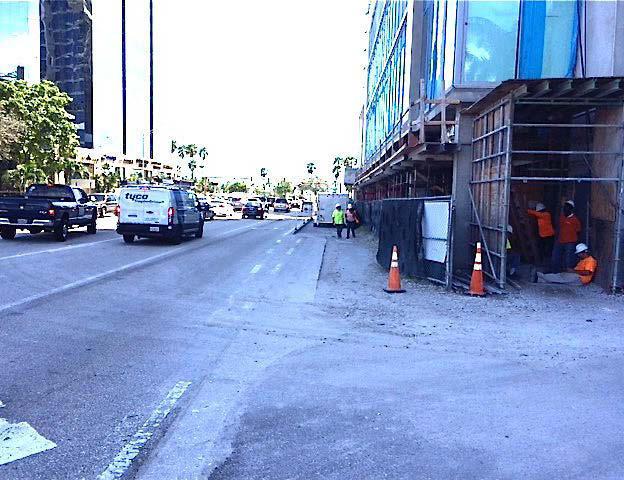
23 Walkability It is not the approach of the City of Sarasota.. Build to the lot line, fit a sidewalk in whatever space remains..if it looks wide, throw in a grass strip or trees. Walkability means allowing enough setback so that there is space for pedestrians and a policy of building these spaces on developments and streets.
24 Walkability Not Utopian ideal of everyone living in a dense urban environment or sustainable village where everyone can walk to work, school, shopping, everything. Fine vision but not prac/cal for much of Sarasota, Bird Key, Lido Key, Longboat Key. Suburbs, less-dense, everywhere, can be walkable
25 Standards to Use Designing Walkable Urban Thoroughfares: A Context-Sensi/ve Approach 2010, The Congress for the New Urbanism, The Ins/tute of Transporta/on Engineers A manual of standards for each project and thoroughfare.
26 4 areas of a streetside: General Urban and Urban Center/Core Frontage Zone: Space between walls and pedestrian throughway, allows window shopping, space for doors Pedestrian Throughway; Furnishings Zone: Space for trees, benches, trash cans, fire hydrants, etc 7-8. Edge Zone: Angled parking overhang, parallel parking doorswing, bus door swing

27

28

29
30 The Vue Latest City Modifica/on ]... Sidewalk Pltr Strip Original City ] Sidewalk, No trees or furnishings 8 through most, as per exis/ng code, (quickly necked down from 12 at north end) DWUT Recommenda/ons ] 17.5 of paved streetside with spaced trees, street furnishings, no edge zone (no parking)

31 Embassy Suites
32 As built Embassy Suites ] 9 6 space, walls to curb probable sdwlk, maybe grass strip DWUT Recommenda/ons ] 17.5 of paved streetside with spaced trees, street furnishings, no edge zone

33 NW Corner, Cocoanut/Boulevard of the Arts

34 NW Corner, Cocoanut/Boulevard of the Arts
35 As built NW Corner, Cocoanut/Boulevard of the Arts ] 9 of paved space Spaced trees and light poles near center of walkway Where tree wells are, pedestrian throughway is 4-5. As per DWUT ] 14.5 of paved streetside with spaced trees, street furnishings

36 635 S. Orange Avenue
37 As built ] of sidewalk of grass strip As per DWUT 635 S. Orange Avenue ] 14.5 of paved streetside with spaced trees, street furnishings
38 Next Step Revise City Zoning Code to allow wider setbacks and require wider sidewalks as per: Designing Walkable Urban Thoroughfares: A Context Sensi/ve Approach, 2010
39 Not So Hard. Other Ci/es in Florida require wide sidewalks.orlando, West Palm Beach. Sarasota used to do it.

40 Pastry Arts, Main Street

41 Lemon Street

42 Two Senoritas, Main Street

43 Palm Avenue

44 Palm Avenue
Presentation Outline. Project/Study Purpose. Existing Conditions. Future Conditions. Understanding the Streetside. Similar Walkable Environments
 Presentation Outline Project/Study Purpose Study Area Map Existing Conditions Future Conditions Understanding the Streetside Similar Walkable Environments Conceptual Alternatives Magnolia/NE 1st Ave Block
Figure 5-1 Complete Street Zones. Roadside. May include frontage, pedestrian throughway, furnishings and curbside areas.
 Design Guidelines 5 The design guidelines presented in this section provide descriptions related to the form and function of the four Complete Streets zones: roadside, parking, roadways and lanes, median,
Typical Cross Section: DOWNTOWN (Observer Highway - 8th Street)
") Typical Cross Section: DOWNTOWN (Observer Highway - 8th Street) DRAFT SEPTEMBER 23, 14 1 Washington Street Typical Block Downtown Typical Block: DOWNTOWN (Observer Highway - 8th Street) New crosswalks
Typical Cross Section: DOWNTOWN (Observer Highway - 8th Street) DRAFT SEPTEMBER 23, 14 1 Washington Street Typical Block Downtown Typical Block: DOWNTOWN (Observer Highway - 8th Street) New crosswalks
Brooklyn Boulevard (County Road 152) Reconstruction Project Phase I. OPEN HOUSE June 20, 2017
 Reconstruction Project Phase I. OPEN HOUSE June 20, 2017") Brooklyn Boulevard (County Road 152) Reconstruction Project Phase I OPEN HOUSE June 20, 2017 Brooklyn Boulevard (County Road 152) Phase I Project Partners Project Lead Other Project Partners include Brooklyn
Brooklyn Boulevard (County Road 152) Reconstruction Project Phase I OPEN HOUSE June 20, 2017 Brooklyn Boulevard (County Road 152) Phase I Project Partners Project Lead Other Project Partners include Brooklyn
Healthy Built Environments Cowlitz-Wahkiakum County, Washington
 Healthy Built Environments Cowlitz-Wahkiakum County, Washington Bringing Back Active Transportation and Health Presented By Dan Burden, Blue Zones, LLC Livability/Health and the role of Place, Walkability
PRINCE GEORGE S PLAZA METRO AREA PEDESTRIAN PLAN
 PRINCE GEORGE S PLAZA METRO AREA PEDESTRIAN PLAN May 28, 2008 Agenda Welcome and introductions Project overview and issue identification Planning context and strengths Design challenges and initial recommendations
STREETSCAPE CONCEPTS
 STREETSCAPE S CARGO WAY CARGO WAY CYCLE TRACK Streetscape Concepts JENNINGS ST Illustrative Plan EVANS AVE PG&E BAY TRAIL HERON S HEAD PARK The recommended improvements build off the planned improvements
Sarasota / Manatee Barrier Islands Traffic Study
 Sarasota / Manatee Barrier Islands Traffic Study PUBLIC INFORMATION WORKSHOP December 5, 2017 North Study Area o City of Anna Maria o Holmes Beach o Bradenton Beach o Coquina Beach o Longboat Key o Bradenton
Microscale Audit of Pedestrian Streetscapes (MAPS), Mini Version
, Mini Version") Microscale Audit of Pedestrian Streetscapes (MAPS), Mini Version Training Manual & Picture Guide Developed by: Carrie Geremia Kelli Cain Revised February 11, 2014 Tool and protocol developed by: James
Microscale Audit of Pedestrian Streetscapes (MAPS), Mini Version Training Manual & Picture Guide Developed by: Carrie Geremia Kelli Cain Revised February 11, 2014 Tool and protocol developed by: James
STEERING COMMITTEE MEETING June 17, Streetscape Overview Burlington Comprehensive Master Plan
 STEERING COMMITTEE MEETING June 17, 2015 Streetscape Overview Burlington Comprehensive Master Plan 1 Introduction Slide This slide show was presented to the Burlington Steering Committee on June 17, 2015
Sarasota High School June 26, 2018
 June 6, 08 June 9, 08 Review of SHS Security & Safety, Community Input & Ideas June 6, 08 Review of Community Concerns and Ideas, Confirm Community Enhancement Priorities July/August, 08 Vacation Application
RESOLUTION NO ?? A RESOLUTION OF THE CITY OF NEPTUNE BEACH ADOPTING A COMPLETE STREETS POLICY
 RESOLUTION NO. 2018-?? A RESOLUTION OF THE CITY OF NEPTUNE BEACH ADOPTING A COMPLETE STREETS POLICY WHEREAS, safe, convenient, and accessible transportation for all users is a priority of the City of Neptune
COMPLETE STREETS PLANNER S PORTFOLIO
 COMPLETE STREETS PLANNER S PORTFOLIO ISSUE 3 APRIL 2016 PLANNER S PORTFOLIO COMPLETE STREETS 1 2 6 10 14 OVERVIEW MATURE NEIGHBORHOODS GROWING SUBURBS CENTRAL PLACES ACTIVITY CORRIDORS Planner s Portfolio
5. Pedestrian System. Accomplishments Over the Past Five Years
 5. Pedestrian System Accomplishments Over the Past Five Years The Alamo Area Metropolitan Planning Organization (MPO) and its partner agencies recognize the importance of improving pedestrian mobility.
A CHANGING CITY. of Edmonton, it is essential that it reflects the long-term vision of the City.
 A CHANGING CITY By the year 2040, Edmonton will be home to more than 1 million people. To accommodate growth and support a healthy and compact city, we need a new approach to development/redevelopment
Clarkson Walkability Audit: Results and Recommendations Summary
 Clarkson Walkability Audit: Results and Recommendations Summary The following document was prepared by the Region of Peel and includes a summary of comments made by participants during our breakout discussion
TRANSPORTATION COMMISSION Agenda Staff Report
 TRANSPORTATION COMMISSION Agenda Staff Report Agenda Item No. 5.a DATE: JULY 31, 2014 TO: FROM: SUBJECT: TRANSPORTATION COMMISSION COMMUNITY DEVELOPMENT DEPARTMENT - PLANNING DRAFT OLYMPIC CORRIDOR PREFERRED
2018 Transportation Alternatives Program (TAP) Application Presentation to Palm Beach TPA BRANT BRIDGE CONNECTION LOOP EXTENSION ON CARL BOLTER DR
 Application Presentation to Palm Beach TPA BRANT BRIDGE CONNECTION LOOP EXTENSION ON CARL BOLTER DR") 2018 Transportation Alternatives Program (TAP) Application Presentation to Palm Beach TPA BRANT BRIDGE CONNECTION LOOP EXTENSION ON CARL BOLTER DR Project Location N N Connecting South Delray Beach Existing
2018 Transportation Alternatives Program (TAP) Application Presentation to Palm Beach TPA BRANT BRIDGE CONNECTION LOOP EXTENSION ON CARL BOLTER DR Project Location N N Connecting South Delray Beach Existing
DRAFT. System Components. Greenway Trails. Introduction. Trail Types. Zebulon Greenway Master Plan
 5 System Components Wakefield Street Photo Simulation showing Sharrows Introduction The Master Plan identifies various system components that, together, create a comprehensive greenway system. These components
NEWMARKET UPHAM S CORNER
 SOUTH STATION Planning Initiative NEWMARKET UPHAM S CORNER COLUMBIA ROAD (P) FOUR CORNERS/GENEVA Working Advisory Group (WAG) Meeting #5 TALBOT AVENUE MORTON STREET BLUE HILL AVE/CUMMINS HWY (P) RIVER
Complete Streets Successes, Opportunities, and Challenges
 Complete Streets Successes, Opportunities, and Challenges Juliet Walker, Transportation Planner, City of Portsmouth Rob Houseman, Director of Planning and Development, Town of Wolfeboro Chris Parker, Director
4/14/2017 VIA . Miriam Lim, Junior Planner City of Sacramento Community Development Department 300 Richards, 3 rd Floor Sacramento, CA 95811
 4/14/2017 VIA EMAIL Miriam Lim, Junior Planner City of Sacramento Community Development Department 300 Richards, 3 rd Floor Sacramento, CA 95811 RE: Mack & Franklin Development (P17-016) Dear Ms. Lim:
9/25/2018. Multi-Modal Level of Service (MMLOS) Bianca Popescu, Transportation Planner
 Bianca Popescu, Transportation Planner") Multi-Modal Level of Service (MMLOS) Bianca Popescu, Transportation Planner 1 What is MMLOS? Is this a nice place to walk? Is this a nice place to bike? Is transit convenient? Bottom line - Are there options
Multi-Modal Level of Service (MMLOS) Bianca Popescu, Transportation Planner 1 What is MMLOS? Is this a nice place to walk? Is this a nice place to bike? Is transit convenient? Bottom line - Are there options
Commerce Street Complete Street Project from Good Latimer Expressway to Exposition Avenue
 Commerce Street Complete Street Project from Good Latimer Expressway to Exposition Avenue T A N Y A B R O O K S A S S I S T A N T D I R E C T O R M O B I L I T Y P L A N N I N G M O B I L I T Y A N D S
Agenda. Overview PRINCE GEORGE S PLAZA METRO AREA PEDESTRIAN PLAN
 PRINCE GEORGE S PLAZA METRO AREA PEDESTRIAN PLAN May 28, 2008 Agenda Welcome and introductions Project overview and issue identification Planning context and strengths Design challenges and initial recommendations
Ann Arbor Downtown Street Plan
 1 Ann Arbor Downtown Street Plan Public Workshop #1 We know that. 2 Public right-of-way (streets, sidewalks, and alleys) make up 30% of the total District area of downtown. Streets need to provide mobility
What Is a Complete Street?
 Session 5 Charleen Zimmer, AICP, Zan Associates May 5-7, 2010 What Is a Complete Street? May 2010 5-1 Not a Complete Street More of a Complete Street May 2010 5-2 Benefits of Complete Streets Safety for
Prince George s County plans, policies, and projects
 Prince George s County plans, policies, and projects Over 250 projects for trails, bikeways, designated bike lanes and sidewalk construction Trail projects that improve access to Metro Sidewalk and trail
Plant City Walk-Bike Plan
 Plant City Walk-Bike Plan Plant City Commute Mode Share 2.2% 1.4% 2.9% Drove alone 10.2% Carpooled Public transportation (0.1%) Walked Used a Bike (0.4%) 82.9% Taxicab, motorcycle, or other means Worked
Chapter 6: Along the Street
 Chapter 6: Along the Street This section describes the types of infrastructure that should be in place along school routes to make walking and bicycling to school safer. Sidewalks In communities with sidewalks,
Does It Work? THE BENCHMARKING PROJECT. State Department of Transportation Project Assessment. Bill Wilkinson and Bob Chauncey
 THE BENCHMARKING PROJECT Does It Work? State Department of Transportation Project Assessment Bill Wilkinson and Bob Chauncey National Center for Bicycling & Walking 1506 21 st Street NW, Washington, DC
TOWN OF PORTLAND, CONNECTICUT COMPLETE STREETS POLICY
 TOWN OF PORTLAND, CONNECTICUT COMPLETE STREETS POLICY I. VISION, GOALS & PRINCIPLES VISION To improve the streets of Portland making them safer and more accessible for all users including pedestrians,
STONY PLAIN ROAD STREETSCAPE
 Jasper Place Revitalization Strategy: Vision The people involved in the Jasper Place Revitalization Strategy envision: Goal 1: Feeling safe in our community Create a community where feeling safe is common--where
Comments The Plan for Port Whitby
 Comments The Plan for Port Whitby April 24th, 2013 Community Meeting #2 Summary Report Prepared by GLPi April 29th, 2013 1 Introduction The purpose of the Port Whitby Secondary Plan Update, Community Improvement
Complete Streets. Designing Streets for Everyone. Sarnia
 Complete Streets Designing Streets for Everyone Sarnia Complete Streets ~ Sarnia ~ 2018 Introduction Our City is made up of a network of streets that we use to go for a walk, cycle to work, drive to the
Bikeway action plan. Bicycle Friendly Community Workshop March 5, 2007 Rochester, MN
 Bikeway action plan Summary The was held on March 5, 2007 at the Rochester Mayo Civic Center. The workshop was hosted by Rochester-Olmsted County Planning Department in collaboration with the League of
Don t be Left Behind: Make Your Community More Walkable Now
 Don t be Left Behind: Make Your Community More Walkable Now Samantha Thomas Blue Zones, LLC Christopher A. Coes Speakers Responsible Real Estate Developers & Investors Nate Johnson Coastal Carolinas Association
Completing the Vision
 Villas of Positano Completing the Vision North A1A Lane Reconfiguration N. Surf Rd. Redirection of Traffic Margaritaville Resort March 4, 2014 1 Completing The Vision Project Limits Hollywood Blvd. to
N. Frederick Street to N. Manchester Street
 November 20, 2014 N. Frederick Street to N. Manchester Street Goals and Summary, November 2007 Map, December 2007 Bicycle Element, July 2008 Pedestrian Element, July 2008 Demand and System Management,
Retrofitting Urban Arterials into Complete Streets
 Retrofitting Urban Arterials into Complete Streets John N. LaPlante, P.E., P.T.O.E., T.Y. Lin International Prepared for: Illinois Traffic Engineering & Safety Conference Urbana, Illinois October 18, 2007
Public Open House #2. THE CITY OF NORTH VANCOUVER CHESTERFIELD AVENUE CYCLING IMPROVEMENTS (4th - 13th STREET) JULY 2013
 JULY 2013") CHESTERFIELD AVENUE CYCLING IMPROVEMENTS (4th - 13th Street) Public Open House #2 1 Chesterfield Avenue provides an important north/south connection between Lonsdale Quay and West 23rd Street Purpose of
CHESTERFIELD AVENUE CYCLING IMPROVEMENTS (4th - 13th Street) Public Open House #2 1 Chesterfield Avenue provides an important north/south connection between Lonsdale Quay and West 23rd Street Purpose of
Guthriesville Village Manual of Written & Graphic Design Guidelines
 Exhibit B Revisions: May 23, June 21, July 20, September 20, & October 9, 2012 Updated: December 13, 2012; June 27, 2013; February 7, 2014 Outline of Contents: 1. Purpose and Applicability 2. Overall Form
Slide. Too close together; Don't like the garages in front; Front-facing garages are not nice; Bland; Looks like suburbs; Only see garages
 1 Slide Visual Preference Survey Results Like driveways and less density; Everything looks squeezed in; Street parking is a turn-off; East Coast look; I like the porches; Garages should be in alleys; Too
CONNECTIVITY PLAN. Adopted December 5, 2017 City of Virginia Beach
 CONNECTIVITY PLAN Adopted December 5, 2017 City of Virginia Beach CONTENTS 1.0 Background & Purpose... 2 2.0 Existing Inventory & Analysis... 3 ViBe District Existing Walking Conditions... 4 3.0 ViBe District
Active Transportation Facility Glossary
 Active Transportation Facility Glossary This document defines different active transportation facilities and suggests appropriate corridor types. Click on a facility type to jump to its definition. Bike
GIS Based Data Collection / Network Planning On a City Scale. Healthy Communities Active Transportation Workshop, Cleveland, Ohio May 10, 2011
 The Purpose of GIS Based Network Planning GIS Based Data Collection / Network Planning Healthy Communities Active Transportation Conference Tuesday, May 10, 2011 10:00 AM Norman Cox, LLA, ASLA. Ann Arbor,
Brian D. Hare, P.E. Bureau of Design PennDOT PA APA Annual Conference Investing in a Sustainable Future October 5, 2009
 Brian D. Hare, P.E. Bureau of Design PennDOT 2009 PA APA Annual Conference Investing in a Sustainable Future October 5, 2009 1 What is Smart Transportation? Photographer: heyjude. Used through license
Aurora Urban Street Standards For Transit Oriented Developments and Urban Centers
 Aurora Urban Street Standards For Transit Oriented Developments and Urban Centers I. Purpose These standards will be applied to create a safe, comfortable, pleasant and pedestrian-friendly multi-modal
TRANSPORTATION STANDARDS
 INTRODUCTION LOCAL STREETS ON-STREET PARKING SIDEWALKS STREET LIGHTING STREET FURNISHINGS TRAFFIC CALMING STREET TREES MEDIAN PLANTING BOULEVARD LOCATIONS VILLAGE CENTER STREET LOCATIONS RESIDENTIAL STREET
RZC Appendix 8A Marymoor Subarea Street Requirements
 RZC Appendix 8A Marymoor Subarea Street Requirements For additional design details for Marymoor Subarea infrastructure, refer to the 2017 Marymoor Subarea Infrastructure Planning Report. STREET REQUIREMENTS
Sponsored by Mrs. Gina Gregory and Mr. Reggie Copeland.
 AN ORDINANCE REGULATION TO AMEND THE SUBDIVISION REGULATIONS FOR THE CITY OF MOBILE, ALBAMA CODES TO CREATE NEW WALKABLE STREET STANDARDS THAT ENABLES TRADITIONAL, WALKABLE VILLAGE AND NEIGHBORHOOD CENTERS
APPENDIX A: Complete Streets Checklist DRAFT NOVEMBER 2016
 APPENDIX A: Complete Streets Checklist DRAFT NOVEMBER 2016 Complete Streets Checklist MetroPlan Orlando s Complete Streets Checklist is an internal planning tool for staff to further implementation of
PROPOSED BYLAW UPDATES AND FEES FOR SIDEWALK CAFÉS & MARKETING DISPLAYS
 Transportation Services Municipal Licensing and Standards PROPOSED BYLAW UPDATES AND FEES FOR SIDEWALK CAFÉS & MARKETING DISPLAYS PUBLIC CONSULTATIONS June 13, 2017 Toronto City Hall June 20, 2017 North
MASTER BICYCLE AND PEDESTRIAN PLAN
 VILLAGE OF NORTHBROOK MASTER BICYCLE AND PEDESTRIAN PLAN DRAFT PLAN OPEN HOUSE May 2, 2018 AGENDA 1. Community Engagement 2. Vision and Goals 3. General Structure of Plan 4. Recommendations Overview 5.
Better Market Street Project Update. Urban Forestry Council September 17, 2014
 Better Market Street Project Update Urban Forestry Council September 17, 2014 Project Area Limits Better Market Street Schedule Market Street City s busiest transit corridor Over 85 buses per hour 14 surface
Creating walkable, bikeable and transit-supportive communities in Halton
 Creating walkable, bikeable and transit-supportive communities in Halton By presenting current research and best practices, the information in this paper is meant to support and broaden discussion on how
Northeast 65 th Street Vision Zero Project Proposals From A Roosevelt High School Student Joe Mangan
 Northeast 65 th Street Vision Zero Project Proposals From A Roosevelt High School Student Joe Mangan PROPOSALS: 1. Extend raised cycle tracks down 65 th Street Northeast. Please do not consider any other
complete streets design and construction standards public primer City of Edmonton
 complete streets design and construction standards public primer City of Edmonton introduction Complete Streets are streets for everyone: people who walk, wheel, bike, take transit, or drive. They are
WELCOME. Purpose of the Open House. Update you on the project. Present a draft recommended plan. Receive your input
 WELCOME Purpose of the Open House The Town of Smiths Falls has initiated the Beckwith Street Redevelopment Plan that includes the preparation of a streetscape functional design for the renewal of Beckwith
Multimodal Through Corridors and Placemaking Corridors
 68 Multimodal Through Corridors and Placemaking Corridors Corridors have different functions in a region. Some corridors are used to get smoothly and rapidly through a region or to get quickly to major
PROPOSED HIGH STREET TRAFFIC CALMING PLAN
 PROPOSED HIGH STREET TRAFFIC CALMING PLAN Pottstown Borough has conducted two studies in recent years to revitalize its downtown area and make its main street, High Street, safer and more attractive for
Complete Streets for Louisiana
 Complete Streets for Louisiana Louisiana Transportation Conference 2011 Ellen W. Soll, AICP Planner Burk-Kleinpeter, Inc esoll@bkiusa.com 504.486.5901 x143 What is a Complete Street? What are Complete
 COMPLETE STREETS CHECKLIST City of Philadelphia The City of Philadelphia's Complete Streets policies are designed ensure that city streets are safe, comfortable and convenient for people of all ages and
NJDOT Complete Streets Checklist
 Background The New Jersey Department of Transportation s Complete Streets Policy promotes a comprehensive, integrated, connected multi-modal network by providing connections to bicycling and walking trip
MAKE YOUR PLACE IN CHANNELSIDE
 MAKE YOUR PLACE IN CHANNELSIDE INTRODUCTION PROJECT LIMITS Channelside Drive from Cumberland Ave to Kennedy Boulevard EXISTING CONDITIONS EXISTING CONDITIONS CHANNELSIDE DRIVE FROM E. CUMBERLAND AVENUE
Table #6 VISION CHARACTERISTICS
 Table #6 VISION White Flint is a place to live, work, play, shop, and walk with sufficient density to encourage quality redevelopment. Vibrant streets and consistent streetscapes are important. CHARACTERISTICS
1000 FRIENDS OF FLORIDA PALM BEACH COUNTY 2070 OCTOBER 2018
 1000 FRIENDS OF FLORIDA PALM BEACH COUNTY 2070 OCTOBER 2018 HEALTHIER COMMUNITIES & BETTER ECONOMIES THROUGH COMPLETE STREETS PRESENTED BY TREASURE COAST REGIONAL PLANNING COUNCIL The Question of Safety
Designing Complete Streets: What you need to know
 Designing Complete Streets: What you need to know Getting from this to this. Continuous sidewalk Buffer w/trees Bicycle lane Raised median Buildings close to the street Flexibility in design Design and
COMPLETE STREET DESIGN: CHALLENGES AND SOLUTIONS. John Pulliam PE and Frederik Venter PE APWA Monterey Bay Chapter November 13, 2013
 COMPLETE STREET DESIGN: CHALLENGES AND SOLUTIONS John Pulliam PE and Frederik Venter PE APWA Monterey Bay Chapter November 13, 2013 ASSHTO Transportation engineers know that the entire system works more
Transportation Planning Division
 Transportation Planning Division Presentation Outline Study Tasks Recap of Previous Meetings Data Collected Focus Areas within Study Limits Design Principles Tool Box Recommended Concepts Schedule Moving
Chestnut Street Bikeway Pilot. A Cycle Track From College Ave. to Mulberry St.
 Chestnut Street Bikeway Pilot A Cycle Track From College Ave. to Mulberry St. Prepared by the Department of Public Works - November 2015 Overview In cities across the nation, and internationally, there
Sidewalk Cafe City of St. Petersburg City Code Chapter 16, Land Development Regulations
 Section 16.50.370 Sidewalk Café Sections: 16.50.370.1 Generally 16.50.370.2 Declarations 16.50.370.3 Definitions 16.50.370.4 Permit Required 16.50.370.5 Application, Permit and Fee 16.50.370.6 Liability
Roosevelt Estates Neighborhood Improvements
 Roosevelt Estates Neighborhood Improvements Transportation Alternatives Application May 5 th, 2016 Qualifying Activities Construction of on-road and off-road trail facilities for pedestrians, bicyclists,
7/23/2017 VIA . Michael Hanebutt City of Sacramento Community Development Department 300 Richards Boulevard, 3 rd Floor Sacramento, CA 95811
 7/23/2017 VIA EMAIL Michael Hanebutt City of Sacramento Community Development Department 300 Richards Boulevard, 3 rd Floor Sacramento, CA 95811 RE: 65 th Street Apartments (DR17-220) Dear Mr. Hanebutt:
Cycling Road Safety Audits
 1 Cycling Road Safety Audits Paul de Leur, PhD, P.Eng. 9th Annual Interna?onal Conference on Urban Traffic Safety, Banff, 2017 2 Presenta?on Outline 1) Cycling as a Viable Transporta?on Alterna?ve 2) Safely
Sidewalk Accessibility Checklist
 Starting Address: Ending Address: Date: Sidewalk Accessibility Checklist Please indicate your experience with any barriers you encountered when using the sidewalks in your neighborhood. 1. Did you have
Route 28 Critical Locations Bicycling Network Connectivity November 2017
 Route 28 Critical Locations Bicycling Network Connectivity November 2017 Nobska Light Chatham Light Prepared by Cape Cod Commission staff on behalf of the Cape Cod Metropolitan Planning Organization and
DEFINING THE STREETSCAPE DRAFT
 3 DEFINING THE STREETSCAPE Context Sensitive Design Context Sensitive Design The structuring elements of streetscapes for the City of Vaughan are road classifi cation, streetscape type and level of service.
Complete Streets. Complete Streets and other City Initiatives. City & County Initiatives. Honolulu Complete Streets Program
 City & County Initiatives Complete Streets and other City Initiatives Health and the Built Environment Hawaii Public Health Conference Mark Garrity Department of Transportation Services City & County of
5 CIRCULATION AND STREET DESIGN
 5 CIRCULATION AND STREET DESIGN This chapter describes circulation and streetscape improvements proposed for the Northwest Chico Specific Plan Area. It includes detailed design specifications for existing
Liveable Neighbourhoods Design Code and Policy
 CNU London Transportation Summit, November 2007 The West Australian Liveable Neighbourhoods Design Code and Policy Incorporating a New Urbanist Street Design Manual for New Communities Wendy Morris Ecologically
Highland Creek Village Transportation Master Plan
 Highland Creek Village Transportation Master Plan Information Booklet On-Street Parking Discussion November 9, 04 Highland Creek Village Transportation Master Plan www.toronto.ca/hcvtransportation Old
2016 Planning Conference July 26, CONNECT COLUMBUS Building Columbus Transportation Future
 2016 Planning Conference July 26, 2016 CONNECT COLUMBUS Building Columbus Transportation Future What Is Connect Columbus? Project Process OUR PROCESS COMPLETE ONGOING Discovery + Desire Project Goals Columbus
AN EARTHWORK HILL, RINGED WITH SEATING AND SHAPED TO SLOPE DOWN TO THE RIVER, FORMS THE CENTERPIECE TO A NEW SOCIAL PIER. A WOOD SEATING TERRACE
 AN EARTHWORK HILL, RINGED WITH SEATING AND SHAPED TO SLOPE DOWN TO THE RIVER, FORMS THE CENTERPIECE TO A NEW SOCIAL PIER. A WOOD SEATING TERRACE FACES SOUTH. A DRAMATIC RAMP RISES ALONG THE NORTH FACE
o n - m o t o r i z e d transportation is an overlooked element that can greatly enhance the overall quality of life for the community s residents.
 N o n - m o t o r i z e d transportation is an overlooked element that can greatly enhance the overall quality of life for the community s residents. 84 Transportation CHAPTER 11 INTRODUCTION Transportation
Elm Street Business District: Streetscape and Signage Plan
 Winnetka Preliminary Streetscape & Signage Village Council Presentation 1 Elm Street Business District: Streetscape and Signage Plan VILLAGE OF WINNETKA DOWNTOWN MASTER PLAN VILLAGE COUNCIL PRESENTATION
Proposed. City of Grand Junction Complete Streets Policy. Exhibit 10
 Proposed City of Grand Junction Complete Streets Policy Exhibit 10 1 City of Grand Junction Complete Streets Policy Vision: The Complete Streets Vision is to develop a safe, efficient, and reliable travel
Small Town & Rural Multimodal Networks
 Small Town & Rural Multimodal Networks Fred Young, PLA Andrea Clinkscales, AICP, PMP Alta Planning + Design Funding Partners Project Team Existing Design Guidance AASHTO Flexibility Guide 2004 AASHTO Bike
City of Wausau Wausau Center Urban Design and Transportation Master Plan. Design Workshop // October 18, 2018
 City of Wausau Wausau Center Urban Design and Transportation Master Plan Design Workshop // October 18, 2018 Design Workshops // October 15-18 Workshop Study Evaluate circulation and parking patterns around
Portage Bay Park Design Commission Review 4: 90% Design Development January 5, 2017
 to be updated to reflect base bid condition Portage Bay Park Design Commission Review 4: 90% Design Development January 5, 2017 Previous Site Plan POTENTIAL PARK CONNECTION & MID-BLOCK CROSSING BOAT STREET
Replace century-old sewer & water pipes Pedestrian-scale sidewalk lighting
 PROJECT OVERVIEW The Masonic Avenue Streetscape Project is an effort to improve safety for everyone travelling on Masonic Avenue between Geary Boulevard and Fell Street. This project will bring a variety
Streets. Safe for Pedestrians 20% 2nd 5,000. Are We People-Friendly?
 Streets Safe for Pedestrians 20% Pedestrian deaths account for more than of all traffic-related fatalities in California each year. 600 More than people are killed and another 13,000 are injured every
2016 Neighborhood Street Fund Application
 2016 Neighborhood Street Fund Application 2016-109 #146 COMPLETE Collector: Web Link 1 (Web Link) Started: Sunday, April 17, 2016 2:29:58 PM Last Modified: Sunday, April 17, 2016 2:36:28 PM Time Spent:
Non-Motorized Transportation 7-1
 Non-Motorized Transportation 7-1 Transportation facilities no longer mean just accommodating a vehicle powered by a combustion engine. Pedestrian and non-motorized facilities are important modes of travel
West Village Mobility & Integration
 West Village Mobility & Integration PRESENTED TO TOPCA Town Hall November 9, 2017 [7189-21] Port Credit 2 West Village + Mobility AWalkable Community A CompleteCommunity A SustainableCommunity 3 Mobility
Road Diets: Reconfiguring Streets for Multi-Modal Travel
 Road Diets: Reconfiguring Streets for Multi-Modal Travel Tom Grant, P.E., PTOE What is a Road Diet? Reconfiguration of travel lanes to benefit all roadway users (i.e., Complete Street) Reclaiming the space
ACTIVE TRANSPORTATION Active Community Checklist
 ACTIVE TRANSPORTATION Active Community Checklist Safe, accessible spaces to walk, hike, bike and play is an important part of building strong, healthy and active communities for residents and visitors.
NORTH LAUDERDALE WALKING AUDIT: VIRTUAL APPENDIX
 NORTH LAUDERDALE WALKING AUDIT: VIRTUAL APPENDIX TABLE OF CONTENTS VIRTUAL APPENDIX A: WALKING AUDIT FINDINGS... 3 Route 1 Notes... 3 Route 2 Notes... 5 Route 3 Notes... 6 Virtual Audit Notes... 8 VIRTUAL
Information on display. Inside this handout. Triangle Area revisions. Project need displays. Preferred alternative on aerial maps
 Public information meeting #4 4 to 7 p.m., September 30, 2009 Hales Corners Welcome Thank you for attending this public information meeting for the WIS 100 Corridor Study. Your interest and comments are
PUBLIC REALM MASTER PLAN
 WESTSHORE BUSINESS DISTRICT PUBLIC REALM MASTER PLAN MASTER PLAN COMMITTEE MEETING MARCH 20, 2013 WESTSHORE BUSINESS DISTRCT PUBLIC REALM MASTER PLAN MACRO-SCALE CONCEPT: A PUBLIC REALM FRAMEWORK DEFINED