CORAL RIDGE COUNTRY CLUB ESTATES NEIGHBORHOOD MOBILITY MASTERPLAN
|
|
|
- Bathsheba Morgan
- 6 years ago
- Views:
Transcription
1 CORAL RIDGE COUNTRY CLUB ESTATES NEIGHBORHOOD MOBILITY MASTERPLAN
2 Coral Ridge Country Club Estates Neighborhood Mobility Masterplan August 2015 Coral Ridge Country Club Neighborhood Mobility Masterplan 2 Prepared for: Prepared By: Coral Ridge Country Club Estates and The City of Fort Lauderdale Transportation and Mobility Department Kittelson & Associates, Inc. 110 E. Broward Boulevard, Suite 2410 Fort Lauderdale, FL 33301
3 CONTENTS INTRODUCTION 5 Project Background 6 Study Process 6 Report Organization 7 Study Area 8 EXISTING CONDITIONS 11 Demographics 12 Land Use and Destinations 14 Street Network 16 Existing Pedestrian and Bicycle Facilities 18 Vehicular Access and Intersection Controls 20 Vehicular Traffic Calming Measures and Posted Speed Limits 22 Vehicular Traffic Volumes 24 Vehicular Traffic Speeds 26 Intersection Operations 28 Pedestrian and Bicycle Experience 30 Crashes 32 COMMUNITY ENGAGEMENT 35 Community Engagement 36 SYNTHESIS 39 Synthesis 40 MASTERPLAN 43 Masterplan 44 Neighborhood Streets Masterplan 44 External Streets Masterplan 52 Cost Estimates and Timing 60 NEXT STEPS 63 Next Steps 64 APPENDIX A: SOUTH NEIGHBORHOOD ROADWAY PLAN 67 APPENDIX B: MAP OF SPEED AND VOLUME COUNT LOCATIONS 71 APPENDIX C: PLANNING LEVEL PRIORITIZATION SCORING 75 FIGURES Figure 1 Study Process 6 Figure 2 Study Area 8 Figure 3 Existing Land Use 14 Figure 4 Street Network 16 Figure 5 Existing Bicycle and Pedestrian Facilities 18 Figure 6 Vehicular Access and Intersection Controls 20 Figure 7 Traffic Calming Measures 22 Figure 8 Traffic Volumes 24 Figure 9 Traffic Speeds 26 Figure 10 Intersection Operations 28 Figure 11 Pedestrian LOS - Bayview Drive 30 Figure 12 Bicycle LOS - Bayview Drive 30 Figure 13 Pedestrian and Bicycle Environment 30 Figure 14 External Crashes 32 Figure 15 Internal Crashes 32 Figure 16 Crash Map 32 Figure 17 Data Synthesis 40 Figure 18 Neighborhood Streets Masterplan 44 Figure 19 External Streets Masterplan 52 Figure 20 Cost Estimates and Timing 60 3 Coral Ridge Country Club Neighborhood Mobility Masterplan
4 4
5 1INTRODUCTION 5
6 PROJECT BACKGROUND Coral Ridge Country Club Estates is an established, vibrant community located on the Intercoastal Waterway in Fort Lauderdale, Florida. Over time, community members have expressed a desire for a safer and more comfortable multimodal environment. In recognition of these desires, the City of Fort Lauderdale initiated the Coral Ridge Country Club Estates Neighborhood Mobility Masterplan. The City is experiencing a resurgence in development and is working to transform itself into a multimodal, active, vibrant community. In order to support this growth and change, the City is working to complete Neighborhood Mobility Master Plans that aim to address transportation, mobility, and access at the neighborhood level in a context sensitive and publicly informed manner. Coral Ridge Country Club Neighborhood Mobility Masterplan 6 The Coral Ridge Country Club Estates Neighborhood Mobility Masterplan examined the existing and future multimodal transportation system; the existing and future land uses; the demographics; and the crash history to better understand the issues in and around the neighborhood. In addition, the community was invited to provide input at various stages throughout the project through a series of public workshops. Based on the analysis and public input, a number of strategies were developed to calm traffic and enhance the pedestrian and bicycling environment in the neighborhood. Together, these strategies will enhance the accessibility, comfort, and overall livability within and around the Coral Ridge County Club neighborhood. STUDY PROCESS The Coral Ridge Country Club Estates Neighborhood Mobility Masterplan was conducted over a period of eight months, beginning in January of 2015 and ending in August The project team took a blank slate approach, with no assumptions on the issues or needs coming in. This allowed the community members, supported by data and analysis, to identify the issues and importance of those issues. This process was completed in four phases, as seen in Figure 1. Beginning with data collection and analysis and stakeholder involvement, phase one identified the issues and opportunities in the neighborhood. In phase two, a general menu of potential improvements were identified and presented to the community. The community was then asked to choose the types of strategies they would like to see implemented in the neighborhood. In phase three, the improvement types decided on in phase two were applied to the specific issue and opportunity areas identified in phase one. Additionally, planning level cost estimates and project timing were developed for the improvements. These were presented to the community and the feedback received was used in phase four to create the final masterplan. Phase four is ongoing, and includes a final prioritization developed between the community members and the City of Fort Lauderdale as well as the implementation of the projects as funds become available. Figure 1 STUDY PROCESS PUBLIC INVOLVEMENT DATA COLLECTION & EXISTING CONDITIONS ANALYSIS POTENTIAL IMPROVEMENT IDENTIFICATION RECOMMENDED IMPLEMENTATION PLAN FINAL MASTERPLAN, PRIORITIZATION, & IMPLEMENTATION

7 REPORT ORGANIZATION This report is organized into five sections as follows: 1. INTRODUCTION Describes the study purpose and background, the process, and the study area. 2. EXISTING & FUTURE CONDITIONS A comprehensive overview of the existing and future conditions in and around the neighborhood, including analysis of the demographics; Study land purpose use and and proposed developments; existing traffic calming devices; multimodal transportation environment; and safety aspects. 3. COMMUNITY ENGAGEMENT Describes the public involvement activities conducted throughout the study, including a high level overview of the results. 4. SYNTHESIS Combines the results of the data analysis and the public involvement efforts to create an overall assessment of the needs, desires, and opportunities in the community. 5. MASTERPLAN Delineates the recommended strategies to address the needs, desires, and opportunities uncovered throughout the project. Also discusses the planning level cost estimates for the recommendations in the study. 6. NEXT STEPS Presents the next steps for the community, including a discussion of the prioritization of the recommendations based on the prioritization methods approved in the City s Connecting the Blocks plan. This is meant to be a starting point for future prioritization efforts by the City and the Community. 7


8 STUDY AREA Coral Ridge Country Club Estates is an established neighborhood in Northeast Fort Lauderdale. Figure 2 displays the project study area. It is bounded by Federal Highway (US 1) to the west, Oakland Park Boulevard to the south, the Intercoastal Waterway to the east, and Commercial Boulevard to the north. Neighborhood Entrance on Bayview Drive. Credit: Kittelson & Associates, Inc. Coral Ridge Country Club Neighborhood Mobility Masterplan 8 Typical Neighborhood Street. Credit: Kittelson & Associates, Inc. Typical Neighborhood Street. Credit: Kittelson & Associates, Inc. Figure 2 STUDY AREA Feet 1,000 Typical Neighborhood Street. Credit: Kittelson & Associates, Inc.

9 9
10 10
11 11 2 EXISTING & FUTURE CONDITIONS
12 12 Coral Ridge Country Club Neighborhood Mobility Masterplan DEMOGRAPHICS According to 2013 estimates from the U.S. Census Bureau, the Coral Ridge County Club neighborhood is home to 4,932 people. Of those, 53 percent are men and 47 percent are women. 42 percent of the population are either under the age of 18 or over the age of 65. These populations are less likely to drive, and therefore require adequate pedestrian and bicycle facilities to get around. Most people have access to at least one vehicle, and 39 percent have access to two or more vehicles. The median household income is around $95,000 per year, which is higher than the city as a whole, where the median income is $58, percent of the population has obtained a bachelor s degree or higher. As income and education levels increase, people become more likely to choose to make trips by walking and biking as opposed to driving, especially for recreational trips. 1 Even though most people have access to a vehicle, adequate pedestrian and bicycle facilities that connect to educational, recreational, and entertainment destinations is important for communities. The central location of the neighborhood in the City of Fort Lauderdale allows for short commute times and a greater transportation mode split. 46 percent of the population commutes less than 1086% miles to WHITE work, and 11 percent of the population uses alternative modes of transportation to commute to work. This is slightly higher 11% than HISPANIC the City s average OR of 9 LATINO percent, which may be due to the above average walkability of the neighborhood. 1% BLACK OR AFRICAN 1 (Kuzmyak, Walters, Bradley, & & Kockelman, 2014) 1% TWO MEDIAN OR AGE MORE IS 54 RACES 12% UNDER 18 30% AGE 65+ POPULATION 4,932 53% MEN 47% WOMEN 1% ASIAN ACCESS TO VEHICLE 0 VEHICLES 4% 1 VEHICLE 57% 2 VEHICLES 32% 3+ VEHICLES 7% MODE SHARE WORKERS AGE % DRIVE ALONE 6.7% TELECOMMUTE 5.2% Walk 4.7% Transit 3.6% CARPOOL 3.6% OTHER 0.5% BIKE
13 COMMUTE DISTANCE 45.8% LESS THAN 10 MILES MEDIAN HOUSEHOLD INCOME $94, % 10 TO 24 MILES EDUCATION AGE 25+ 6% LESS THAN HIGH SCHOOL 21% HIGH SCHOOL 16% SOME COLLEGE 5% ASSOCIATES DEGREE 29% BACHELORS DEGREE 23% MASTERS DEGREE OR HIGHER 9.5% 25 TO 50 MILES 11.9% GREATER THAN 50 MILES 13


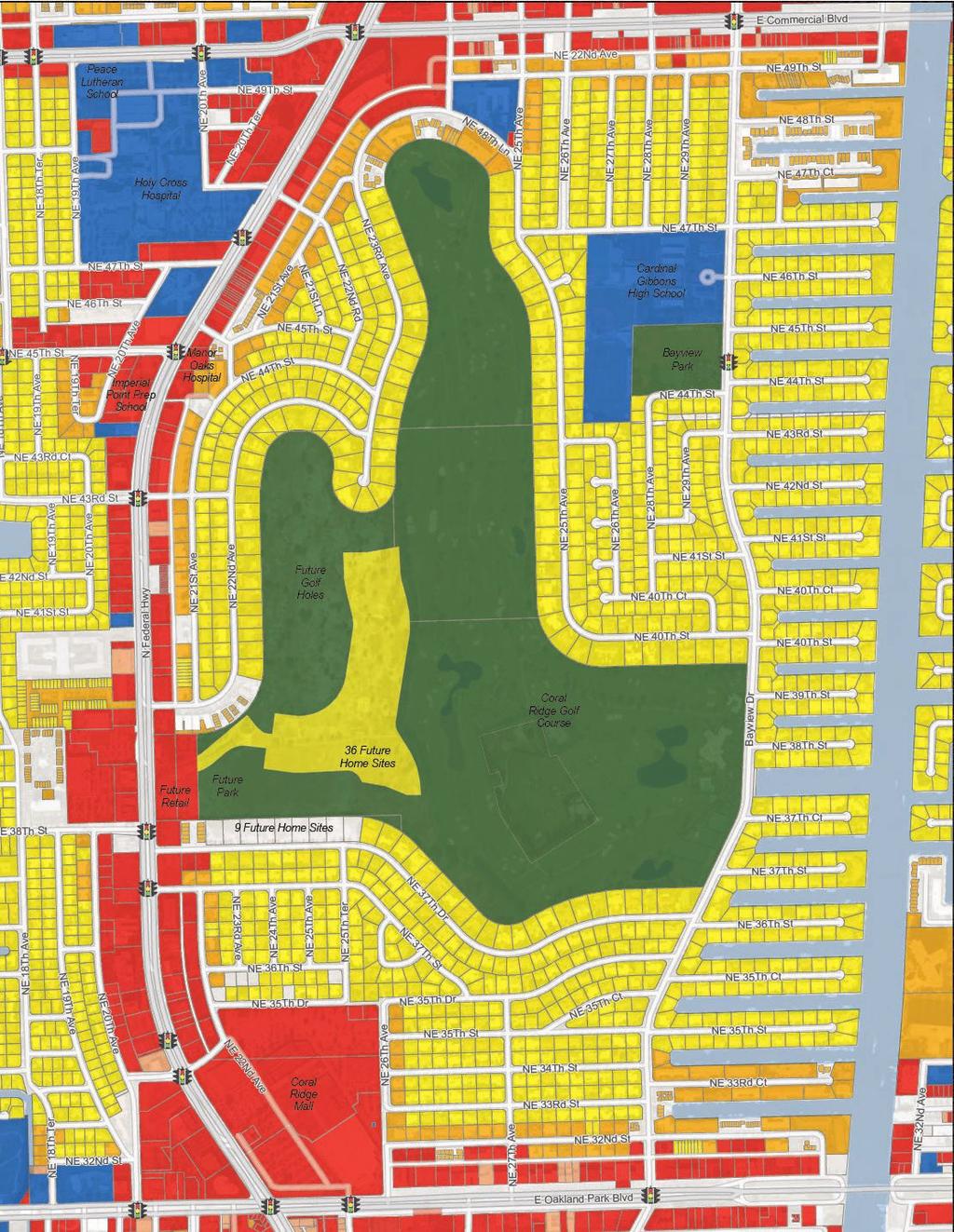
14 LAND USE AND DESTINATIONS Figure 3 displays the Existing Land Use in Coral Ridge Country Club Estates. The neighborhood is unique in that while it is comprised largely of single- and some multi-family homes, it is surrounded by commercial and medical districts. It is also home to the Coral Ridge Mall (a regional shopping center with a movie theatre); the Coral Ridge Country Club and Golf Course (another regional attractor); Cardinal Gibbons High School; Bayview Park; a number of other retail and commercial uses; several hospitals, schools, and churches; and some of the last remaining developable land in Fort Lauderdale. That land is currently being developed as a retail shopping center, a linear park, and 45 future homes. Because of this land use mix, it is possible to complete some daily activities without the need for a car and Coral Ridge Country Club Estates ranks 28 out of 61 neighborhoods in Fort Lauderdale for walkability, with a Walk Score of Additionally, this unique mix of uses means that the neighborhood must accommodate both residents and outside visitors on a regular basis. 2 (Walk Score, 2015) Coral Ridge Country Club Neighborhood Mobility Masterplan 14 Bayview Park. Credit: Kittelson & Associates, Inc. Figure 3 EXISTING LAND USE Feet 1,000 Coral Ridge Mall. Credit: Kittelson & Associates, Inc.
15 15

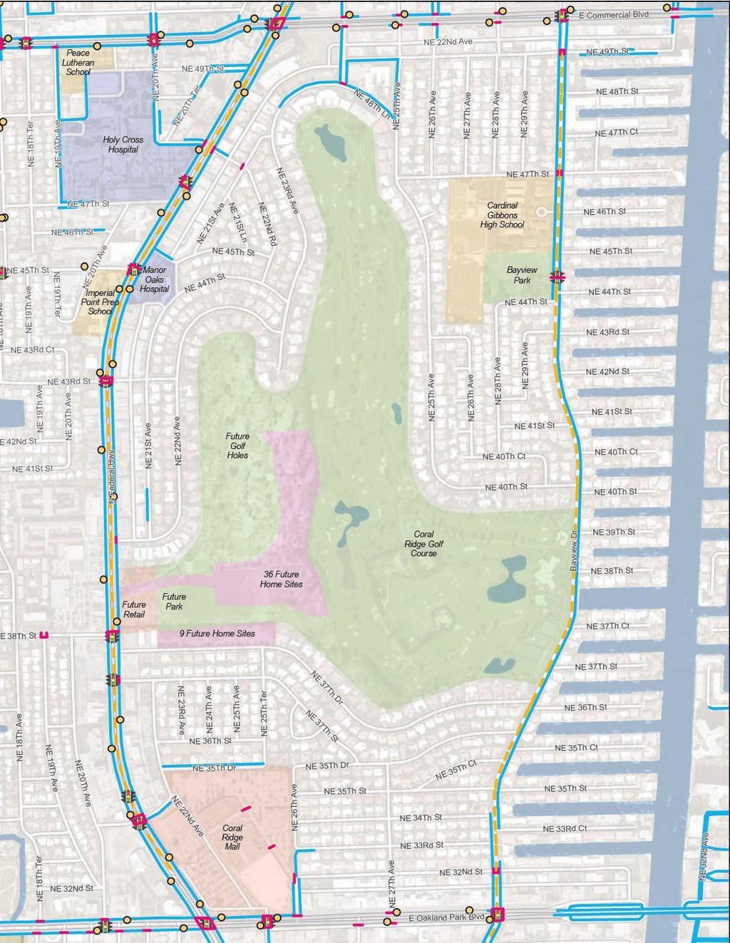
16 STREET NETWORK To support multimodal activity and development, the City of Fort Lauderdale has classified its streets according the types of users as well as the surrounding land uses and environmental factors in its Connecting the Blocks plan. As shown in Figure 4, there are four types of streets found in and around Coral Ridge Country Club Estates: Commercial Boulevards Serve primarily commercial or mixed uses and act as main thoroughfares that connect activity centers and support constant medium- to highvolumes of traffic at moderate speeds. They also serve as primary transit routes and routes for goods movement. In general, they should include dedicated bicycle facilities, pedestrian enhancements, and transit accommodations. Commercial Avenues Coral Ridge Country Club Neighborhood Mobility Masterplan 16 Connect development nodes, and act as secondary facilities to Commercial Boulevards, serving a more local population. They may have lower density uses with larger setback than would be found in activity centers, but they may also be transitioning to higher densities. They support transit routes and are still have somewhat higher speeds than other avenues. They should have wide sidewalks and bike lanes. Residential Avenues Are smaller in scale than Commercial Avenues and serve as lower-speed alternative routes that connect neighborhoods. Surrounding land uses are mainly residential and primarily carry local traffic. They also serve as primary pedestrian and bicycle routes, and may serve as local transit routes; therefore, they should have sidewalks and bicycle lanes. Neighborhood Streets Can be commercial or residential in nature. They have low speeds and serve low traffic volumes. They are also considered essential for pedestrian and bicycle transportation. Depending on the speeds and volumes, vehicles may share the street with pedestrians and bicyclists or there may be designated pedestrian and bicycle facilities. Figure 4 STREET NETWORK Feet 1,000
17 17

18 EXISTING PEDESTRIAN AND BICYCLE FACILITIES As can be seen in Figure 5, while there generally are sidewalks surrounding much of the neighborhood on the major roads, there are very few internal pedestrian and bicycle connections. While there are a number of destinations that people may wish to walk to, the lack of pedestrian facilities may make walking more difficult than driving. The exception to this is on Bayview Drive, where there is a sidewalk on at least one side of the road through the entire community. However, it is important to note that the sidewalk south of Bayview Park is located on the east side of the road, where the major destinations are on the west side. These destinations include Coral Ridge Golf Course, Bayview Park, and Cardinal Gibbons High school. The sidewalk alternates sides, requiring pedestrians to cross Bayview where there are not always crossings. Due to the lack of pedestrian infrastructure in that area, residents living in the southwest portion of the neighborhood may have a difficult time reaching those destinations on foot. Coral Ridge Country Club Neighborhood Mobility Masterplan 18 There is also a pedestrian connection to Coral Ridge Mall on NE 33 rd Street and NE 32 nd Street. However, there are no sidewalk connections within the neighborhood to connect to them. Additionally, there is no connectivity to the mall on NE 35th Drive and there is a fence blocking the mall off from the neighborhood on that road as well as NE 26 th Avenue. Because of this, it is difficult to access the mall on foot, as the fence requires people to walk out of their way to access their destination. On the north side, the most noticeable issues is that sidewalks are lacking along Commercial Boulevard to connect to the transit infrastructure and surrounding retail. There are no marked bicycle facilities in or around the community. While there are paved shoulders on parts of Federal Highway and Bayview Drive, these shoulders measure less than 4 feet in width. The high traffic volumes and speeds on Federal Highway create an unfriendly environment for bicyclists, and a shared use path or protected, marked facilities would be needed to create a more inviting environment for all riders. Bayview Drive is a well-known (although unsigned) bicycle route in the City due to its location as a parallel route to Federal Highway. However, the lack of comfortable bicycle facilities may cause it to be less accessible for recreational or inexperienced cyclists, as well as for children. Figure 5 EXISTING BICYCLE AND PEDESTRIAN FACILITIES Feet 1,000 Cyclist on Bayview Drive. Credit: Kittelson & Associates, Inc.
19 19

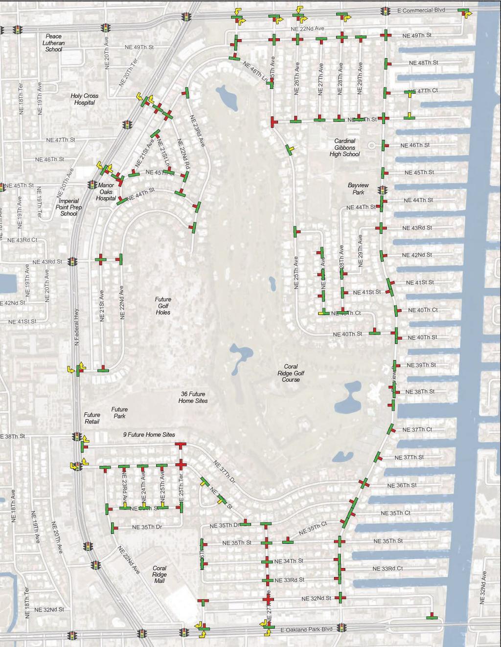
20 VEHICULAR ACCESS AND INTERSECTION CONTROLS Figure 6 shows vehicular access points for Coral Ridge Country Club Estates and intersection controls within the neighborhood. A number of methods have been employed in the neighborhood to assist in traffic calming. To begin, access and egress are restricted in many areas. With the exception of signalized intersections, almost every exit allows only right turns. In most cases, it is permissible to turn left in, however traffic volumes and speeds make these movements less desirable than entering or exiting at signals. Almost every intersection in the neighborhood has a form of traffic control such as a stop sign or yield sign on one or more legs. Figure 6 displays these controls. Bayview Drive, NE 37 th Street, NE 22 nd Ave, NE 25 th Ave, and NE 47 th Street function as through streets, with side streets generally yielding to traffic on those streets. Additionally, streets that provide access to the neighborhood are generally given the through movement. Coral Ridge Country Club Neighborhood Mobility Masterplan 20 Figure 6 VEHICULAR ACCESS AND INTERSECTION CONTROLS Feet 1,000 Typical Stop Controlled Intersection. Credit: Kittelson & Associates, Inc.
21 21

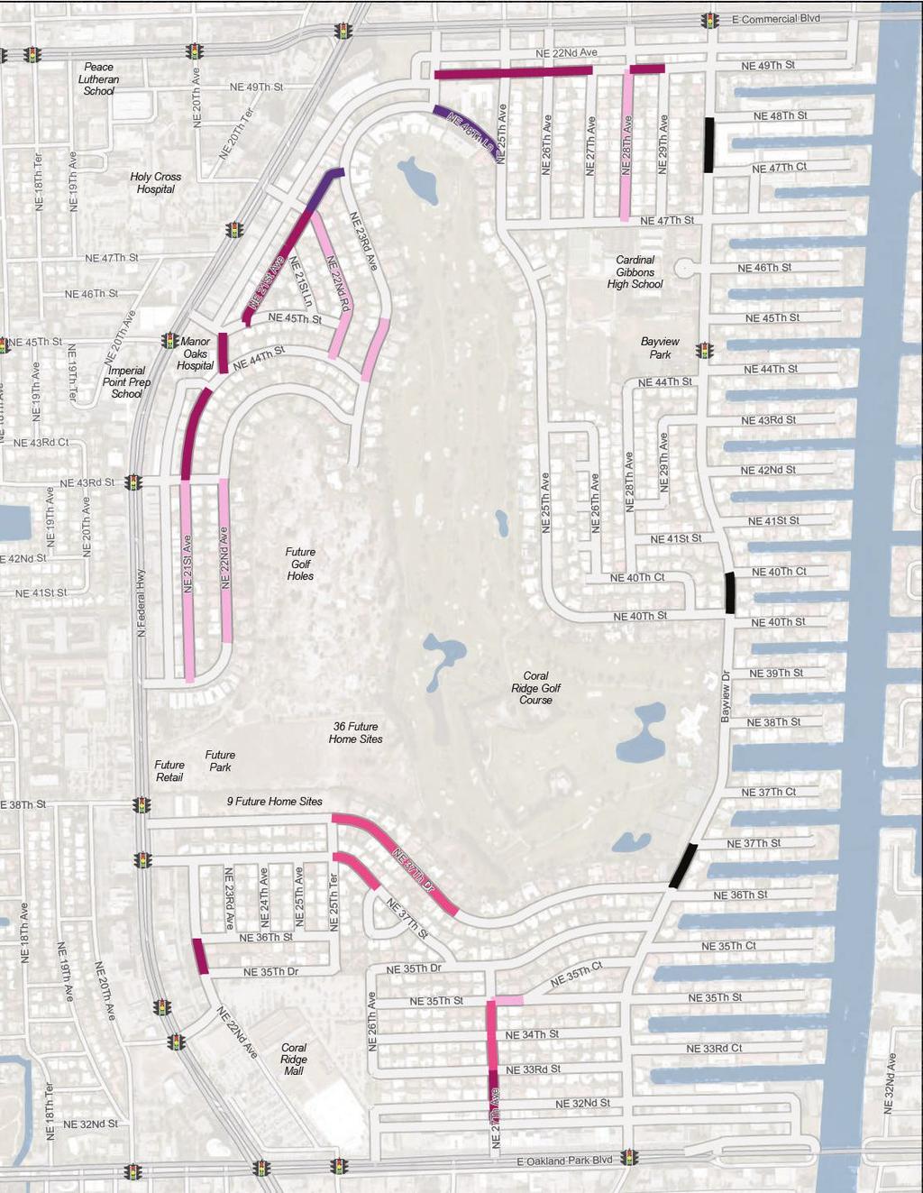
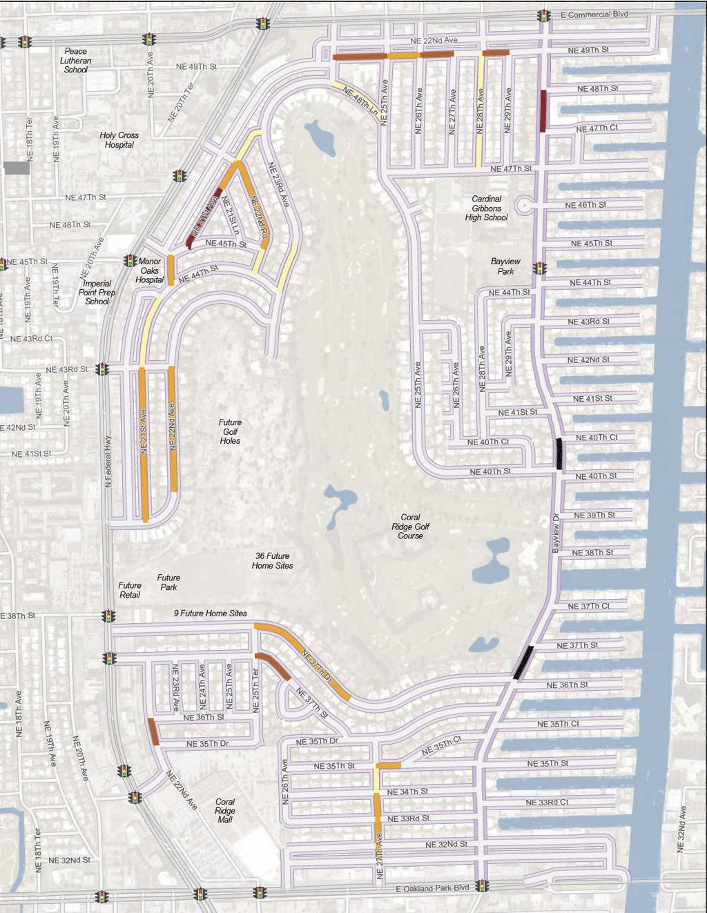
22 VEHICULAR TRAFFIC CALMING MEASURES AND POSTED SPEED LIMITS Traffic calming measures in Coral Ridge Country Club Estates generally take the form of speed humps and road closures, as shown in Figure 7. Speed humps are present on many streets within the neighborhood, particularly where there are long blocks that are uninterrupted by intersections. However, there is not a consistent pattern regarding their placement. There are two street closures within the neighborhood. The first is on NE 25 th Avenue between NE 32 nd Street and NE 33 rd Street, where only a pedestrian connection remains open. The second is along NE 35 th Drive between NE 25 th Terrace and NE 25 th Avenue. Both road closures came about as a result of the South Neighborhood Roadway Plan, a plan funded by Coral Ridge Country Club Estates. The plan was not fully implemented and recommended further road closures. However road closures are no longer a desirable traffic calming feature, since they tend to increase traffic volumes on adjacent streets. Although these are not recommended, a map of the proposed road closures from the South Neighborhood Roadway Plan can be found in Appendix A. Coral Ridge Country Club Neighborhood Mobility Masterplan 22 Posted speed limits in Coral Ridge Country Club Estates range from 15 to 30 miles per hour (mph). The area speed limit is currently 25 mph and is posted at most entrances to the neighborhood. Along Bayview Drive, the posted speed limit is 30 mph, and there is a school zone in the vicinity of Cardinal Gibbons High School with a 15 mph speed limit from 7:35 to 8:05 AM and from 2:30 to 3:00 PM. Alleys within the neighborhood have 15 mph posted speed limits. Generally, 20 MPH is a preferable speed limit for neighborhood streets where pedestrians, bicycles, and cars may share the road. 3 3 (Kulash, 2001) Figure 7 TRAFFIC CALMING MEASURES Feet 1,000 Speed Hump on NE 25th Ave. Credit: Kittelson & Associates, Inc.
23 23


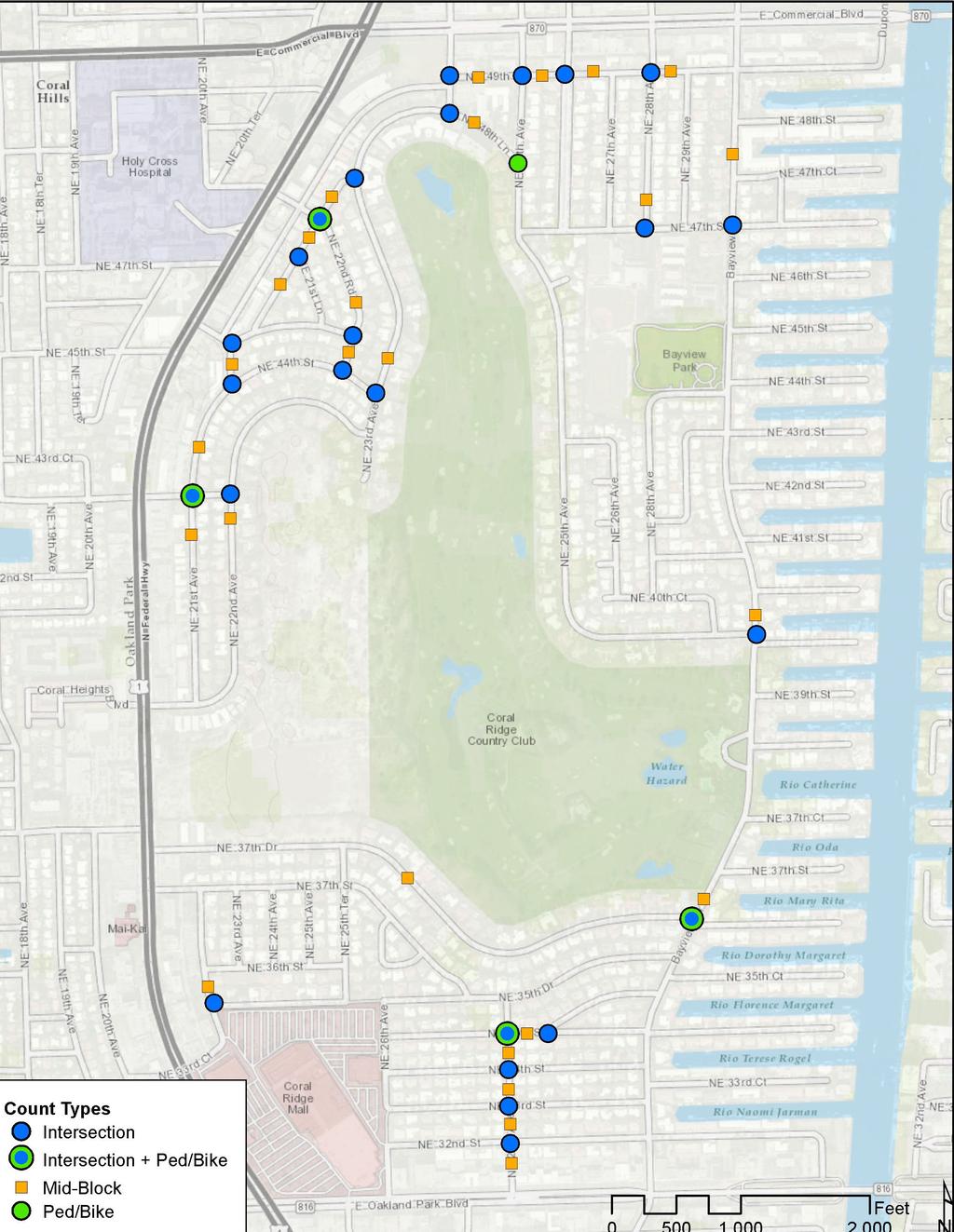
24 VEHICULAR TRAFFIC VOLUMES As part of this study, traffic information was collected in January 2015 for the AM peak and PM peak periods. This includes vehicular and pedestrian counts; vehicular speeds; and turning movement counts at select locations. A map of the data collection locations can be found in Appendix B. The speed and volume data is available upon request from the City of Fort Lauderdale. When considering the average daily traffic shown in Figure 8, it becomes clear that most of the traffic is concentrated along Bayview Drive and in the northern portion of the neighborhood. This was expected on Bayview Drive, as it is a north/south alternative connection for Federal Highway and is classified as a Residential Avenue. In general, local streets (Neighborhood Streets) should serve 1,500 vehicles per day or less and Residential Avenues, such as Bayview Drive, serve more than 1,500 vehicles per day. 4 However, there are other streets in the northern portion of the neighborhood that see over 1,500 vehicles per day. While these are classified as Neighborhood Streets, they may be serving more as low volume Avenues. These include NE 21 st Avenue north of NE 43 rd Street and NE 48 th Lane, which may serve student trips to Cardinal Gibbons High School as well as serving as access points to neighborhood businesses. Coral Ridge Country Club Neighborhood Mobility Masterplan 24 In general, the traffic volumes relate to neighborhood or business access points. With the exception of Bayview Drive, the traffic is higher in areas that serve business of other destinations and lower in areas that serve mainly to provide internal connectivity. 4 (Kulash, 2001) Figure 8 TRAFFIC VOLUMES Note: Traffic volumes were collected at points along the roadway. These volumes were attributed to the entire segment where the count was located for analysis purposes, although actual volumes may vary Feet 1,000 Bayview Drive. Credit: Kittelson & Associates, Inc.
25 25
26 VEHICULAR TRAFFIC SPEEDS Speed data was collected at several locations throughout the community as well. A map of the data collection locations can be found in Appendix B. The speed and volume data is available upon request from the City of Fort Lauderdale. Based on this data, drivers generally exceed the posted speed limit of 25 miles per hour on, NE 22 nd Avenue, NE 37 th Street, NE 21 st Avenue, and NE 49 th Street. Prevailing speeds along Bayview Drive are also higher than the posted speed limit of 30 miles per hour, reaching up to 38 miles per hour. Additionally, it should be noted that construction was occurring along NE 37th Drive while the counts were collected. This may have affected the actual speeds. When the traffic speed results are evaluated relative to the placement of existing stop signs as compared to the speeds, the data suggests that drivers are either speeding in between stop signs or running them. This is true on NE 21 st Avenue, NE 49 th Street, and NE 27 th Avenue, in particular. When considering the placement of speed humps and the locations where drivers are exceeding the speed limit, it appears that in general, drivers are less likely to exceed the speed limit in places where speed humps exist. However, even in some of those areas, drivers are still traveling faster than the desired speed of 20 mph in most cases. This suggests that a combination of measures may be needed to slow drivers down. Coral Ridge Country Club Neighborhood Mobility Masterplan 26 Figure 9 TRAFFIC SPEEDS Note: Traffic speeds were collected at points along the roadway. These speeds were attributed to the entire segment where the count was located for analysis purposes, although actual speeds may vary Feet 1,000
27 27
28 INTERSECTION OPERATIONS Existing vehicular traffic operations were analyzed for several intersections within Coral Ridge Country Club Estates using the traffic counts that were collected. The turning movement count data is available upon request from the City of Fort Lauderdale. The intersection analysis was performed at the intersections with the eight highest traffic volumes using the current Highway Capacity Manual analysis standards and focused on the worst-case intersections that have the highest traffic volumes. Figure 10 summarizes the results of the intersection operations assessment. All of the highest-volume intersections analyzed within the neighborhood operate below capacity, with less than 85 percent of the traffic capacity used during the peak periods. Based on these results, the lower volume intersections are also estimated to operate below capacity. Coral Ridge Country Club Neighborhood Mobility Masterplan 28 Figure 10 INTERSECTION OPERATIONS Feet 1,000
29 29

30 Coral Ridge Country Club Neighborhood Mobility Masterplan 30 PEDESTRIAN AND BICYCLE EXPERIENCE As discussed earlier, the majority of streets within Coral Ridge Country Club Estates lack sidewalks and bicycle lanes. As such, pedestrians and bicyclists currently share the travel way with automobiles. While this situation may not pose concerns for certain streets, it creates safety conflicts when there is fast-moving traffic or high traffic volumes. To assess the quality of the existing pedestrian and bicycle environment, traffic volumes and speeds were analyzed within the neighborhood. The analysis was also intended to assist in prioritizing needed improvements within the neighborhood. Figures show the results of this evaluation. Bayview Drive was analyzed separately, as discussed later in this section. Neighborhood streets with low volumes (fewer than 500 vehicles per day) and low speeds (less than 20 miles per hour) were considered to have a more favorable environment for pedestrians and bicyclists sharing the travel way with automobiles. Streets with higher traffic volumes and faster vehicle speeds were considered to have a less favorable environment, and separate facilities for pedestrians and bicyclists should be considered. Neighborhood streets with the poorest environment for pedestrians and bicyclists using the street include NE 21 st Ave, NE 49 th St, NE 37 th St, NE 37 th Dr, NE 22 nd Ave and NE 27 th Ave. BAYVIEW DRIVE MULTIMODAL LEVEL OF SERVICE Pedestrian and bicycle level of service conditions were analyzed along Bayview Drive using Multimodal Level of Service (MMLOS) analysis standards. The pedestrian LOS addresses the safety and comfort for those walking along the street and for those crossing the street. The bicycle LOS addresses the safety and comfort of those bicycling along the street. As can be seen in Figure 11, The pedestrian LOS analysis showed poor conditions during the PM peak hour, when vehicular traffic is greater. Within the neighborhood, there is only one signalized crossing of Bayview Drive, which is problematic given the traffic volumes and speeds. The bicycle LOS analysis (Figure 12) showed fair conditions along the corridor; however the safety and comfort for bicyclists can be improved through bike lanes or other accommodations. Figure 11 PEDESTRIAN LOS - BAYVIEW DRIVE Time Period AM Peak PM Peak Figure 12 BICYCLE LOS - BAYVIEW DRIVE Time Period AM Peak PM Peak Pedestrian Movement Walking northbound Walking southbound Crossing the street Walking northbound Walking southbound Crossing the street Bicycle Movement Traveling northbound Traveling southbound Traveling northbound Traveling southbound LOS Figure 13 PEDESTRIAN AND BICYCLE ENVIRONMENT C D D C E F LOS D C D C Feet 1,000
31 31
32 Coral Ridge Country Club Neighborhood Mobility Masterplan 32 CRASHES Crash data was collected for the five year period between 2010 and 2015 using data collected from Signal Four Analytics, a compendium of crash data collected from law enforcement agencies across the State of Florida and managed by the University of Florida. There were a total of 1,030 crashes in the study area, with 666 (65%) occurring within 100 of an intersection and 364 (35%) occurring along segments outside of the intersection influence areas. The majority of the crashes in the area occurred along the major roads outside of the community (Federal Highway, Commercial Boulevard and Oakland Park Boulevard). These crashes were considered separately from those occurring within the community. Figure 14 and Figure 15 display the breakdown of the external and internal crash types, respectively, and Figure 16 displays all crash locations. EXTERNAL ROADWAYS There were a total of 892 crashes on the roads surrounding the neighborhood. The majority of these occurred within 100 feet of an intersection. The intersections with the highest numbers of crashes include Federal Highway at Oakland Park Boulevard, at Commercial Boulevard, at NE 33rd Street, and at NE 47th Street. The most common crash types were Other crashes and Rear End crashes, making up 288 and 248 of the 896 crashes, respectively. There were also 21 pedestrian crashes and 19 bicycle crashes. There was one fatality, which was a pedestrian fatality, and there were 331 injuries. This equates to one in three crashes on the roads surrounding Coral Ridge Country Club Estates resulted in an injury. The majority of these crashes occurred close to pedestrian generators including the Coral Ridge Mall and near the transit stops in front of Holy Cross Hospital. It should be noted that although pedestrians are crossing at this location, there are no marked pedestrian crossings. INTERNAL ROADWAYS There were a total of 138 crashes on the streets within the neighborhood. The majority of these were also within 100 of an intersection, and the intersections with the highest numbers of crashes were all on Bayview Drive. They are located at NE 32nd Street, NE 46th Street, NE 47th Court, and NE 49th Street. While the most common type of crashes were Other, Rear End, and Angle crashes, making up 39, 29, and 23 of the 134 crashes, respectively. There were no fatalities, but 39 injuries, meaning that more than one in four crashes within the community resulted in an injury. There were five pedestrian crashes and two bicycle crashes. The bicycle crashes occurred mainly at intersections and exclusively in the northern portion of the neighborhood. The pedestrian crashes occurred mid-block, with two occurring along NE 32nd Street (which leads to Coral Ridge Mall), and the remaining three occurring in the northern portion of the study area. Figure 14 EXTERNAL CRASHES Figure 15 INTERNAL CRASHES Figure 16 CRASH MAP Feet 1,000
33 33
34 34
35 35 3 COMMUNITY ENGAGEMENT
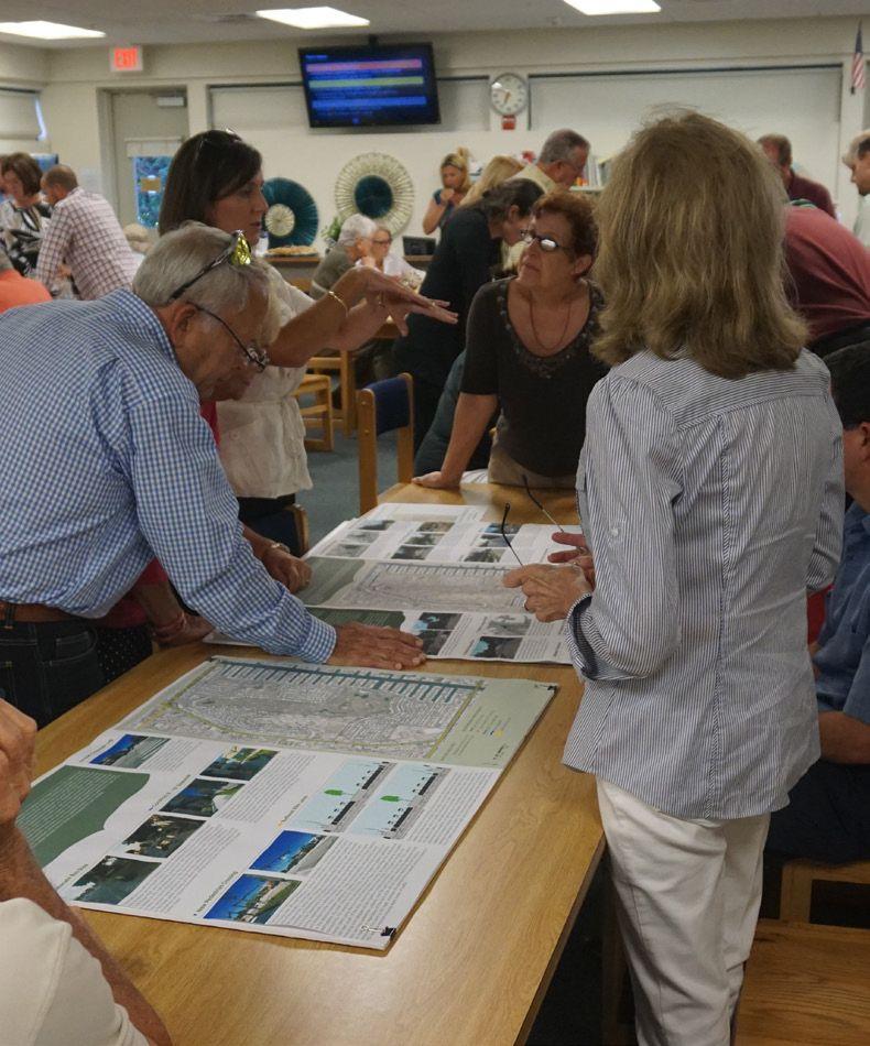
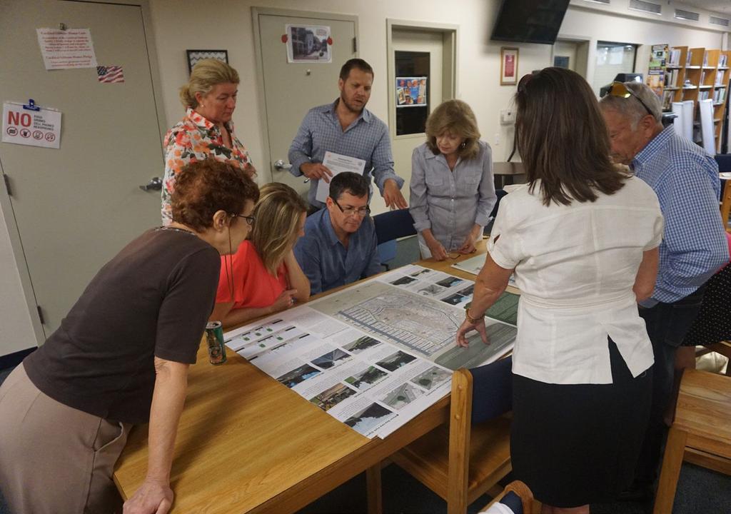
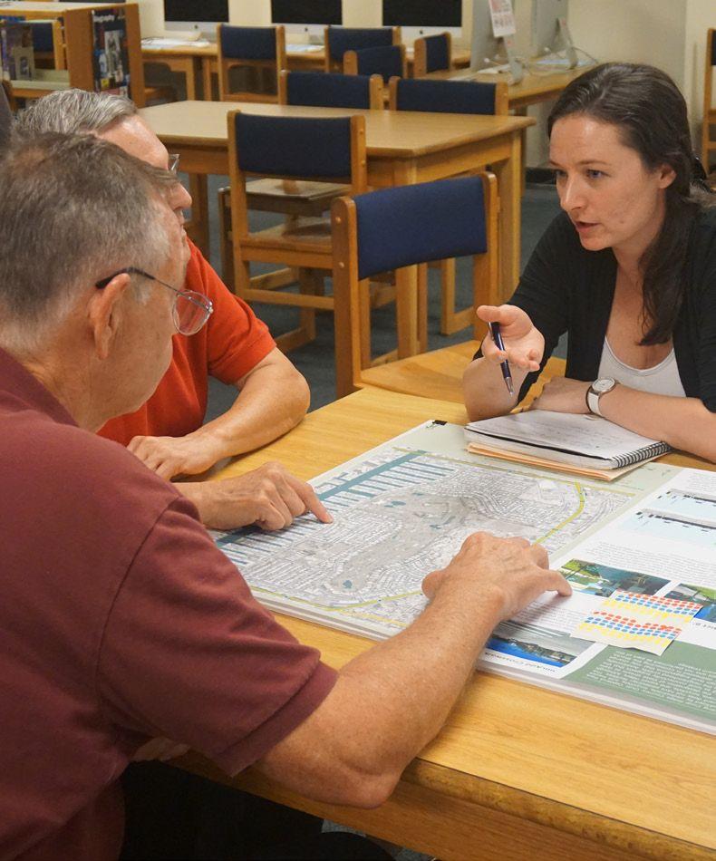
36 Coral Ridge Country Club Neighborhood Mobility Masterplan 36 COMMUNITY ENGAGEMENT While created and supported by strong technical analysis, this plan is intended primarily to represent the needs and desires of the community. In order to do this, a series of public workshops were held at three Coral Ridge Country Club Estates Home Owner s Association meetings at Cardinal Gibbons High School. The first was held on January 22, 2015 at 7:00 PM, the second was held on April 23rd, 2015 at 6:30 PM, and the third was held on June 25th, 2015 at 6:30 PM. Each meeting had a different focus, and each one is summarized in this section. For more information, including a list of attendees from each meeting and a full summary of the issues, comments, and responses, please see the Public Involvement Summary Technical Memorandum, available from the City of Fort Lauderdale. The first workshop provided community members with an introduction to the project and allowed for initial comment on the issues and opportunities in the neighborhood. A total of 62 community members and 6 project team members attended the first workshop. At this workshop, community members were asked to post their issues and concerns on a series of maps. Feedback was also solicited through comment forms and via phone and . This feedback was used as the basis for the recommendations and framework of the plan. The main issues identified were the need for traffic calming; better pedestrian and bicycle connectivity; stormwater management; and neighborhood beautification. At the second workshop, the results of the existing conditions analysis were presented along with a synthesis map of the issues and opportunities and a menu of potential solutions. A total of 40 residents and 8 project team members attended the second workshop. To help the community members evaluate the potential solutions, high level measures of effectiveness for traffic calming and the pedestrian and bicycle environment were presented. Residents were able to comment on the issues and opportunities identified, as well as point out where issues were missed. They also selected their favorite strategies and discussed the ones they did not want to see in their neighborhood. A total of 382 comments were received when considering the strategies and improvement locations combined, which were used to help select the draft recommendations for the masterplan. The most liked strategies included miniroundabouts, chicanes, mini median islands, sidewalks, landscaped medians, and bike lanes. The third meeting tied the project together for the community. The draft Masterplan, which was created utilizing a combination of the information, values, and opinions gathered from the previous meetings and the other data and analysis, was presented for comment. Additionally, high level cost estimates were provided for the strategies and the plan as a whole. A total of 27 residents and 8 project team members attended the third meeting. In general, most residents were happy with the recommendations. There were a total of 44 comments received, and most were focused on the strategies. This resulted in several strategies being added for traffic calming. Additionally, there was some debate about sidewalks. While they were clearly supported along Bayview Drive and around Cardinal Gibbons High School, the desire for them in other parts of the neighborhood was divided. It was determined that sidewalks would remain in the masterplan, however the neighbors would prioritize them as they desire. As this plan is a living document, the sidewalks can be built if, when, and where the neighbors ultimately decide. A future meeting to prioritize the strategies will be held for the community by City staff. At this meeting, each strategy will be given a priority. It is intended to be the Community s plan, as they have the largest stake in it. The City and other agencies will, in the future, be able to continue to work with Coral Ridge Country Club Estates to implement the strategies once they are prioritized and as funding becomes available.


37 Coral Ridge Country Club Neighborhood Mobility Masterplan 37
38 38
39 4 SYNTHESIS 39

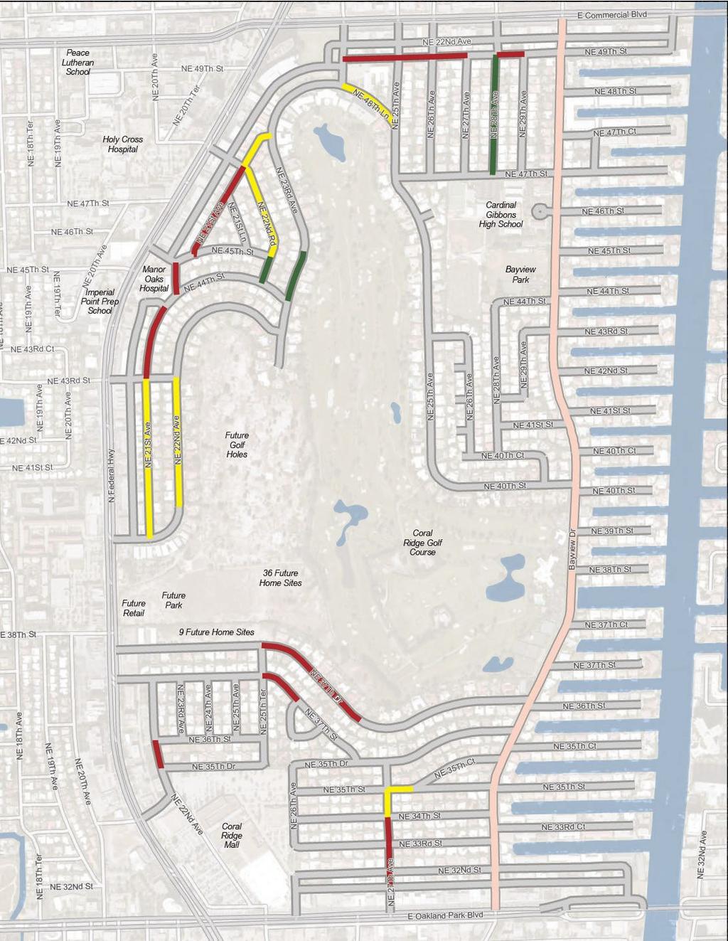
40 Coral Ridge Country Club Neighborhood Mobility Masterplan 40 SYNTHESIS Based on the stakeholder involvement and the analysis of the existing transportation, land use, and socioeconomic conditions, the following primary conclusions for the Coral Ridge Country Club Estates study area can be drawn: There are a number of destinations in the study area. Because of their proximity to the residential uses and the good overall connectivity in the study area, they create key pedestrian and bicycle desire lines. The majority of these fall along major roads, which suggests increased need for pedestrian and bicycle paths. There is a need for additional traffic calming along major roads, as they currently exhibit speeds that exceed the desired maximum for the area. This is especially true when considering the potential for pedestrian and bicycle trips along those roads. Key intersections and streets for pedestrian, bicycle, and vehicular connectivity are apparent in several locations where major roads meet. These intersections and streets should support all modes, including providing safe crossings for bicyclists and pedestrians. There are several areas where pedestrian and bicycle crashes are concentrated. The majority of these lie along Federal Highway. In these stretches, there are bus stops and attractors on either side of the road. However, marked crosswalks are not as frequent as may be desired in the area based on the character. Additionally, long signal cycle lengths require long waits for pedestrians at marked crossings. These factors may encourage people to cross at undesignated locations. THREE GOALS In general, the synthesis points to the following goals: 1. Calm Traffic 2. Reduce Cut Through Traffic 3. Enhance Pedestrian and Bicycle Environment Figure 17 presents the issues and opportunities uncovered from the synthesis. The issues identified generally focus on areas where multimodal connectivity, access, comfort, and safety improvements can be made to achieve the three aforementioned goals. This map does not represent solutions; rather, it was a starting point for discussion with community members about the issues and opportunities in Coral Ridge Country Club Estates. Therefore, the masterplan (i.e. solutions) map reflects different information. Figure 17 DATA SYNTHESIS Feet 1,000
41 41
42 42
43 5 MASTERPLAN 43
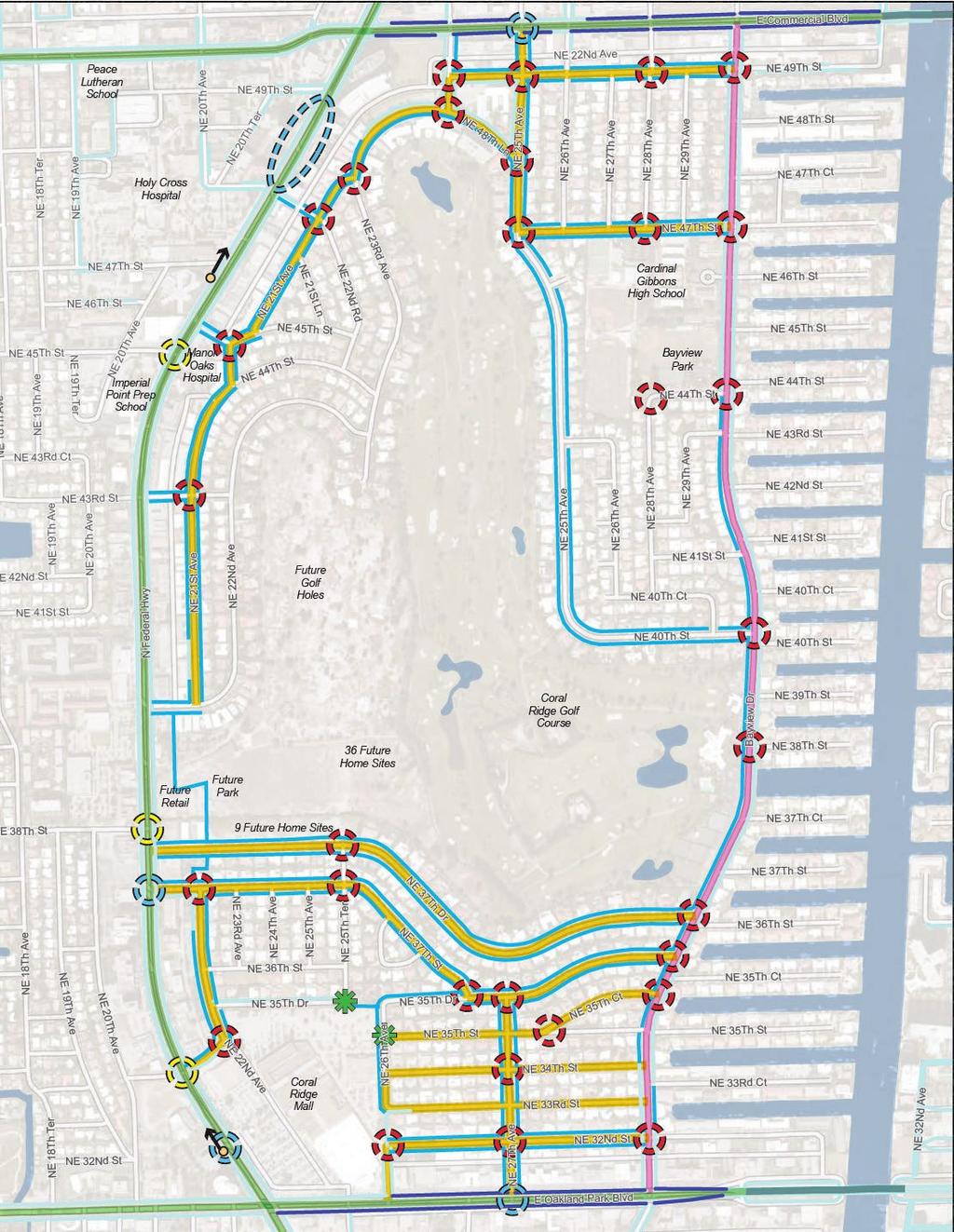
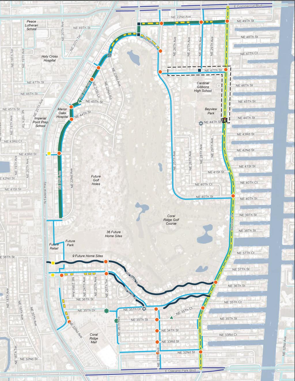
44 MASTERPLAN Based on the analysis and community input conducted throughout the project, a number of context sensitive strategies were developed to calm traffic and enhance the pedestrian and bicycling environment in the neighborhood. Together, these strategies will enhance the accessibility, comfort, and overall livability within and around the Coral Ridge County Club neighborhood. The overall masterplan is split into two parts: the Neighborhood Streets Masterplan and the External Streets Masterplan. The Neighborhood Streets Masterplan generally focuses on internal streets located within Coral Ridge Country Club Estates. The External Streets Masterplan considers the three state roadways that bound the neighborhood: Oakland Park Boulevard, Federal Highway, and Commercial Boulevard. NEIGHBORHOOD STREETS MASTERPLAN The Neighborhood Streets Masterplan focuses on streets internal to Coral Ridge Country Club Estates. These streets generally function as internal connections for residents, with the exception of Bayview Drive which carries trips to neighborhood destinations and beyond. Coral Ridge Country Club Neighborhood Mobility Masterplan 44 In order to achieve the neighborhood s goals, the Neighborhood Streets Masterplan recommends intersection, mid-block, and street focused traffic calming strategies as well as enhancements to the pedestrian and bicycling network. Figure 18 presents a comprehensive summary of the recommendations. The images and descriptions on the following pages provide various details and examples for each strategy. Figure 18 NEIGHBORHOOD STREETS MASTERPLAN Feet 1,000
45 45


46 MINI ROUNDABOUT A small circular or oblong island used in the middle of intersections and intended to force vehicular traffic to slow and negotiate around it. They also increase vehicular safety. It may or may not be landscaped and has mountable curbs for emergency vehicle access. Flagler Village Mini Roundabout. Credit: Kittelson & Associates, Inc. RAISED INTERSECTION 46 Coral Ridge Country Club Neighborhood Mobility Masterplan The entire area of an intersection is raised above normal pavement surface level to reduce vehicle speed through the intersection and provide a better view of pedestrians and motorists in the intersection. These were recommended in areas with high pedestrian activity. TIGHTEN TURNING RADII Large turning radii facilitate faster vehicle turning movements and increase crossing distance for pedestrians. Reducing the curb radii will aid in reducing vehicular speeds as well as the potential for pedestrian-vehicular interaction. Miami Road Raised Intersection. Credit: Kittelson & Associates, Inc.


47 GATEWAY TREATMENT Gateway treatments provide a clear indicator to drivers that they are entering a neighborhood. These treatments can be attractive landmarks that foster a greater sense of community. Treatments may vary and should be designed and agreed upon by the community and the City. Coral Ridge Country Club Estates Gateway. Credit: Kittelson & Associates, Inc. NEW PEDESTRIAN ACCESS AT CORAL RIDGE MALL Street closures at NE 35th Drive and NE 26th Avenue require residents to travel out of their way to reach the Coral Ridge Mall when walking or bicycling. New pedestrian access points would allow for better access from the southwest and central potions of the neighborhood. MOVE BAYVIEW PARK SIGNAL The current signal location does not provide good access to the entrance of Bayview Park. Moving it to the intersection at NE 44th Street will allow for a more direct route for pedestrians and smoother traffic operations. Potential Entry Point. Credit: Kittelson & Associates, Inc. 47 Coral Ridge Country Club Neighborhood Mobility Masterplan Current Signal Location. Credit: Kittelson & Associates, Inc.


48 IMPROVE SCHOOL CROSSING It was requested that crossing opportunities for students be improved in the school zone around Cardinal Gibbons High School. In addition to improvements along NE 47th Street and at NE 44th Street, a new marked pedestrian crossing is recommended at NE 47th Street and Bayview Drive. This could be supplemented with a crossing guard during school hours if desired. Current Signal Location. Credit: Kittelson & Associates, Inc. POCKET PARK/CHANGE GEOMETRY 48 Coral Ridge Country Club Neighborhood Mobility Masterplan In this scenario, pocket parks are intended to help tighten the curb radii at wide intersections. At the same time, they beautify the area by adding a community open space that will also slow down traffic turning movements. The pocket parks will be mostly passive spaces with shade trees. Additionally, each park will have one to two benches to provide a comfortable resting space for users.


49 CHICANE A series of fixed objects, usually extensions of the curb, which alter a straight roadway into a zigzag path to slow vehicles. Chicanes reduce the speed of motorists but are still easy to navigate. They facilitate one- or twoway traffic. Riverside Park Chicane. Credit: Kittelson & Associates, Inc. MEDIANS AND MINI MEDIAN ISLANDS Islands constructed between travel lanes can help to narrow the lanes and thus slow down traffic. Additionally, they may be landscaped, helping to beautify the neighborhood. Mini median islands, which are generally the appropriate treatment at the neighborhood scale, remain short so as not to block access to driveways or back-out parking lots throughout the neighborhood. Medians are longer and wider, and are better suited for collector streets like Bayview Drive where there is less back-out parking. Mini Median Island. Credit: Google Harbor Drive Median. Credit: Kittelson & Associates, Inc. 49 Coral Ridge Country Club Neighborhood Mobility Masterplan

 50 Coral Ridge Country Club Neighborhood Mobility Masterplan Bike lane markings designate a portion of the street for non-motorized bicycle use, separated from")

50 SIDEWALK Sidewalks provide a minimum level of comfort for pedestrians, absent of any other features. However, sidewalks are missing throughout the neighborhood and pedestrians are forced to walk in the street. An interconnected network of sidewalks will improve pedestrian comfort and accessibility. A 3 grass buffer will separate the sidewalk from the street. Sidewalk in Coral Ridge Country Club Estates. Credit: Google BIKE LANE (BAYVIEW DR) 50 Coral Ridge Country Club Neighborhood Mobility Masterplan Bike lane markings designate a portion of the street for non-motorized bicycle use, separated from vehicles by pavement markings. They improve safety and comfort by increasing the visibility and awareness of cyclists, and help bicycling to better appeal to all levels of experience. SHARROW A sharrow is a pavement marking that can be used where space does not allow for a bike lane. Sharrows remind motorists of the presence of bicycles and indicate to cyclists where to safely ride within the street. Sharrows are designated on streets with higher bicycle volumes. Las Olas Boulevard Bike Lane. Credit: Kittelson & Associates, Inc. NE 8th Street Sharrows. Credit: Kittelson & Associates, Inc.


51 BAYVIEW DRIVE IMPROVEMENTS Bayview Drive is the main thoroughfare in Coral Ridge Country Club Estates. It also serves as a parallel route to Federal Highway, connecting from Sunrise Boulevard and the Galleria Mall to northern Fort Lauderdale. Due to this, it carries the highest traffic volumes in the neighborhood. However, because of its prime location and connectivity, it also serves as a main pedestrian connector. Since it has relatively lower speeds and traffic volumes in comparison to Federal Highway, it is a good parallel route for bicycles as well. For these reasons, Bayview Drive has been considered for a Complete Streets treatment. Due to funding availability and time, the redevelopment is phased. The short-term solution can be achieved within the existing street and includes 10-foot travel lanes with 5-foot bike lanes in each direction. The long term solution involves landscaped medians, bike lanes, and sidewalks, and fits within the existing 80 right-of-way. However existing landscaping within the right of way may potentially need to be removed to accommodate the long term vision. This will require further coordination with the property owners who may be impacted prior to implementation. Coral Ridge Country Club Neighborhood Mobility Masterplan 51

52 EXTERNAL STREETS MASTERPLAN The External Streets Masterplan focuses on the three state roadways surrounding Coral Ridge Country Club Estates: Oakland Park Boulevard, Federal Highway, and Commercial Boulevard. Although they are all utilized by pedestrians, bicyclists, and transit riders, none of the streets currently have bicycle facilities and Commercial Boulevard does not have pedestrian facilities. The main goal of the External Streets Masterplan is to improve these streets for pedestrians, bicyclists, and transit riders. Although this plan is part of the overall Coral Ridge Country Club Estates Neighborhood Masterplan, the designation of these streets as state highways as well as the fact that they serve to provide regional connectivity as well as local connectivity suggests that the improvements will likely be funded by different sources and in a different manner than the neighborhood streets. Additionally, due to the complex nature of these streets, these improvements are intended to be high level suggestions that may change based on further analysis. The external streets are owned by the Florida Department of Transportation, and therefore the final definition and implementation of improvements are up to the Department. Even so, there are opportunities to influence improvements, especially during resurfacing projects and for safety improvements. Coral Ridge Country Club Neighborhood Mobility Masterplan 52 Many of these improvements are based on recommendations delineated in Connecting the Blocks, Fort Lauderdale s multimodal connectivity masterplan and therefore more detailed analysis was not performed as part of this plan. The images and descriptions on the following pages provide various details and examples for each strategy. Figure 19 EXTERNAL STREETS MASTERPLAN
53 53


54 ADD CROSSWALK LEG There are three locations along Federal Highway where crosswalk legs are missing on one side of a signalized intersection. It is recommended that the missing legs are completed to allow for better pedestrian accessibility. Further study may be necessary to determine precise placement of crosswalks. NE 4th St at Federal Highway. Credit: Kittelson & Associates, Inc. CONSTRUCT 8-10 SIDEWALK 54 Coral Ridge Country Club Neighborhood Mobility Masterplan The external streets have the potential to facilitate a large number of pedestrian trips based on land uses and destinations. In order to allow for this and to improve pedestrian comfort, 8-10 sidewalks should be constructed on both sides of the external streets. Where possible, sidewalks should be separated from the street by a 3 grass buffer and should be shaded by shade trees. Additionally, existing sidewalks should be expanded or redeveloped to meet these minimums. This may occur as part of a larger project or piecemeal as redevelopment occurs. Flagler Village. Credit: Kittelson & Associates, Inc. Flagler Village. Credit: Kittelson & Associates, Inc.


55 REMOVE CHANNELIZED RIGHT TURN LANE Channelized right-turn lanes provide vehicles with a free-flowing lane with which to make right turns. This can create a dangerous condition for pedestrians as drivers are traveling at higher speeds, unimpeded, and often looking backwards for gaps in traffic. Although many channelized right-turn lanes feature pedestrian crosswalks, yielding compliance among drivers may not always occur. Because of the potential for pedestrian activity, it is recommended that the feasibility of removing channelized right turn lanes be assessed. Channelized Right Turn Lane. Credit: Google RELOCATE BUS STOP There are two locations on Federal Highway where relocating bus stops may help better serve transit riders. The more southern of the two locations serves the Coral Ridge Mall, and is currently positioned well. However, if a new pedestrian crossing is created at the mall entrance, the stop should be relocated north of the intersection to allow the bus to stop prior to the intersection, reducing the impact to traffic flow. The northern stop relocation brings the stop closer to the nearest pedestrian crossing to facilitate easier crossing of Federal Highway for transit riders. These potential stop relocations will require coordination with Broward County Transit, and will require further study. BCT Stop. Credit: Kittelson & Associates, Inc. BCT Shelter. Credit: Kittelson & Associates, Inc. 55 Coral Ridge Country Club Neighborhood Mobility Masterplan


56 NEW PEDESTRIAN CROSSING There are not many existing opportunities for pedestrians to cross the external streets in the study area, although there are a number of destinations and transit stops on either side of the streets. In some cases, distances between crossings exceed a quarter mile. Because of this, several new crossings are recommended. None of them are currently signalized, and therefore would require coordination with both Broward County and the Florida Department of Transportation to install new signals and change the signal timing. Additionally, a warrant analysis has not been performed on any of these locations, and therefore further study is required. These recommendations are generally based on the distance between pedestrian crossings, the location of bus stops, the location of destinations, the crash history from 2010 to 2015, and the desire for greater pedestrian connectivity. For example, the proposed crossing in front of Coral Ridge Mall would serve transit riders using the bus stop at that location. Currently, the nearest crossing is located 360 feet south of the stop, requiring riders to travel a total of 720 feet (4 minutes, not including time delayed at the signal or crossing the street) out of their way. This location also saw two pedestrian crashes over the past five years, meaning that people are crossing there regardless of the lack of an official crossing. Additionally, the crossing distance at this point is 100 feet, whereas the distance at the nearest existing crossing is 130 feet and requires crossing eight lanes of traffic. 56 Coral Ridge Country Club Neighborhood Mobility Masterplan NE 6th St at Federal Highway. Credit: Kittelson & Associates, Inc. NE 4th St at Federal Highway. Credit: Kittelson & Associates, Inc.
57 BUFFERED BIKE LANES Connecting the Blocks recommends that the lanes be narrowed on all three external streets and bike lanes be striped. State policy requires these lanes to be buffered to provide a greater level of comfort and safety to riders. However, if right-of-way does not allow for buffers, 5 bike lanes should be painted. While further study is required to determine the availability of right-of-way on the streets, an example cross section was created for Federal Highway and submitted to FDOT for consideration for an upcoming roadway rehabilitation project. This cross section proposes narrowing roadway lanes to 10 or 11 feet to provide enough space for buffered bike lanes within the existing roadway Sidewalk Shoulder Drive Lane Drive Lane Drive Lane Landscaped Median Drive Lane Drive Lane Drive Lane Shoulder Sidewalk Existing Curb Line Existing Curb Line EXISTING TYPICAL SECTION ON FEDERAL HIGHWAY Existing Curb Line Sidewalk Buffered Bike Lane Drive Lane Drive Lane Drive Lane Landscaped Median 96 Drive Lane Drive Lane Drive Lane Buffered Bike Lane Sidewalk 111 PROPOSED TYPICAL SECTION ON FEDERAL HIGHWAY Coral Ridge Country Club Neighborhood Mobility Masterplan Existing Curb Line

58 SUSTAINABILITY BEST PRACTICES 58 Coral Ridge Country Club Neighborhood Mobility Masterplan As a coastal city, Fort Lauderdale depends on and is sustained by water. This has been one of the City s greatest assets since its inception, however it has also posed some unique challenges. The City is frequently the target of hurricanes during hurricane season and continuously faces the impacts of climate change, such as sea level rise, flooding, salt water intrusion into the water supply, and other related issues. To prepare for and address these issues, Fort Lauderdale has implemented adaptive measures to ensure the sustainability of the City s infrastructure and strives to incorporate sustainable practices into daily living. These efforts are supported by policy in the City s 2035 Vision, Fast Forward Fort Lauderdale, and in the 2018 Strategic Plan, Press Play Fort Lauderdale. MANAGE STORMWATER RUNOFF It was noted throughout the project that drainage and flooding is an issue along Bayview Drive and in some other portions of the neighborhood. In addition to the use of pervious surfaces, treelined streets, and native landscaping, there are other methods of managing stormwater (and associated drainage issues). For example, rain gardens can be planted in small parks that collect, store, and filter rainwater. They, and other retention and filtration techniques, can also be incorporated into curb extensions, chicanes, and street planters. In recognition and support of the City s goals and vision, it is recommended that strategies to support sustainability be woven throughout the improvements recommended in the Coral Ridge Country Club Estates Neighborhood Mobility Masterplan. The strategies discussed can be incorporated into the design of some of the improvements that is implemented as a result of this plan. Not only do they provide resiliency, but they improve the environment and beautify the surroundings. These treatment details were not presented to the community, but they are generally accepted practices for sustainability should the community wish to include them. Rain Garden in Swale. Credit: Edward Belden, Los Angeles and San Gabriel Rivers Watershed Council


59 PERMEABLE SURFACES Impermeable surfaces, such as traditional roads, driveways, sidewalks, and any other surface that prevents water penetration into the soil disrupt the flow of water into natural drainage cycles. Therefore, the use of impervious surfaces can exacerbate stormwater runoff and associated flooding and pollution issues. Permeable pavements should be considered for all new sidewalk, street, and driveway projects to help alleviate these issues. The aesthetics of permeable paving can also give the illusion of a narrower street and help to calm traffic. Permeable pavement at PNC Bank in Fort Lauderdale. Credit: Kittelson & Associates, Inc. TREE-LINED AND SHADED STREETS Street trees help create a sense of enclosure along the road (sometimes referred to as a street wall ), narrowing a driver s field of vision and thus encouraging lower vehicle speeds. If placed between the road and the sidewalk, they can help provide a physical and visual buffer between pedestrians and vehicles. They also help to lower temperatures, provide shade for pedestrians, and absorb stormwater and airborne pollutants. NATIVE LANDSCAPING Native landscaping involves using plants and other vegetation that is indigenous to the Fort Lauderdale area. Plants native to a specific region have adapted to the local soil, conditions, and weather patterns. Therefore, native plants are low maintenance and do not require much (or any) pesticides, fertilizers, watering, or mowing. As a whole, this improves the quality of the air, water, and environment while conserving water, energy, and money. Tree Lined Street in Victoria Park. Credit: Kittelson & Associates, Inc. 59 Coral Ridge Country Club Neighborhood Mobility Masterplan Native landscaping at PNC Bank in Fort Lauderdale. Credit: Kittelson & Associates, Inc.
60 COST ESTIMATES AND TIMING Planning-level cost estimates and typical construction timelines were developed for this plan. The cost estimates and project timelines in Figure 20 are intended to assist the community in prioritizing improvement solutions. The timelines include the length of time for design and construction of each improvement. The masterplan map has been included for reference on the opposite page. Due to multiple agencies being responsible for the maintenance and operations for the roadways in the External Streets Masterplan, available funding and costs are not reflected herein. Those costs and funding will need to be determined outside of this plan among the various responsible agencies. The costs for the reconstruction of Bayview Drive are listed separately from the other improvements because it is assumed that Bayview Drive will be completed as one project. Additionally, costs for long term redesign of Bayview Drive are not included as they depend highly on the future corridor design. Figure 20 COST ESTIMATES AND TIMING The cost estimates present a high level picture of the costs for the improvements for planning purposes only. They include construction costs but do not take into account the costs of design, construction engineering inspection, the movement of utilities, or impacts or changes to existing drainage structures. Additionally, appropriate resources should be used to create a context-sensitive concept in the design of each improvement from which to base a more detailed cost estimate. The timing estimates associated with each improvement represent the general length of time from design through construction. They do not represent prioritization or actual project timelines, and are intended to provide a general picture of the length of time that it may take to complete a project once it has begun. Coral Ridge Country Club Neighborhood Mobility Masterplan 60 Notes: Improvement Quantity (Number or total feet) Cost Per Improvement (in 2015 Dollars) Total Cost (in 2015 Dollars) Low End High End Low End High End Internal Streets (Excluding Bayview Drive) Mini Roundabout 18 $40,600 $45,600 $730,800 $820,800 Mini Median Island 10 $13,300 $14,900 $133,000 $149,000 Chicane 10 $29,200 $32,800 $292,000 $328,000 Move Bayview Drive Signal Raised Intersection 3 $31,800 $35,800 $95,400 $107,400 1 $265,100 $298,200 $265,100 $298,200 5 Sidewalk 38,190 Feet $3,900 $4,400 $1,485,500 $1,676,000 Sharrow 7,140 Feet $5,800 $6,500 $82,800 $92,800 Tighten Turning Radii 2 $2,500 $3,000 $5,000 $6,000 Pocket Park 2 $2,600 $3,500 $5,700 $6,400 Gateway Treatment 3 Based on Agreed Upon Design Short Term Includes Mini Roundabouts, Bike Lanes, and Sidewalks Long Term Includes Complete Street Reconstruction Bayview Drive N/A N/A N/A $447,200 $501,900 N/A *Cost estimates include construction costs but do not include design and construction engineering inspection costs. *Low end estimate is based on a 20 percent contingency and high end estimates are based on a 30 percent contingency. *Costs for improved pedestrian crossings included in costs for associated improvements: Signal at Bayview Drive and NE 44th Street; Raised Intersection at NE 47th Street and NE 28th Avenue; and Mini-Roundabout at Bayview Drive and NE 47th Street. Based on Future Corridor Concept Design Timing IMPROVEMENT TIMING/PHASING KEY Less than 1 Year 1 to 2 Years 2 to 5 Years More than 5 Years
61 61
62 62
63 63 6 NEXT STEPS
64 Coral Ridge Country Club Neighborhood Mobility Masterplan 64 NEXT STEPS The Coral Ridge Country Club Estates Neighborhood Mobility Masterplan is a community driven plan based on input from community members and supported by data and analysis. It is intended to provide a roadmap to a safe, connected, comfortable, and multimodal transportation network within and around the Coral Ridge Country Club Estates neighborhood. It is also one piece of the greater puzzle that, when complete, will help to achieve the City of Fort Lauderdale s vision for a connected and vibrant future. This plan is comprehensive and is intended to be implemented over time as funds become available and the community members see fit. Therefore, further prioritization is needed to ensure that the implementation schedule accurately represents the needs and desires of the community members. This prioritization is left to the discretion of the community members, however the City of Fort Lauderdale staff intends to help guide the community in developing this prioritization. To assist in the prioritization process, each internal street improvement has been assigned a number of points based on the prioritization methodology developed in the City s Connecting the Blocks plan. External streets were also considered as part of this to help quantify the benefits of the improvements even though they will likely be made as FDOT, developers, or the City implements other projects. The methodology takes into account the prioritization needs developed by the City and the Broward Metropolitan Planning Organization. However, because the improvements were ranked on a project basis as opposed to as a whole, the scoring should not be considered comprehensive and instead should be taken as one data point in the overall prioritization process. The scoring and scoring criteria can be found in Appendix C. Regarding the funding of the plan, a variety of sources are available now and more will likely become available in the future. The creation and adoption of this plan enables the Coral Ridge Country Club Estates neighborhood to be eligible for those funds, and neighborhood support increases the likelihood that improvements will be built. Possible funding sources include private developers as new construction occurs around the community; grants applied for by the community, the City, Broward County, the Broward Metropolitan Planning Organization, and the Florida Department of Transportation; and a variety of other innovative sources as they are developed.
65 Coral Ridge Country Club Neighborhood Mobility Masterplan 65
66 66
67 67 APPENDIX SOUTH NEIGHBORHOOD ROADWAY PLAN A
68 Coral Ridge Country Club Neighborhood Mobility Masterplan 68 SOUTH NEIGHBORHOOD ROADWAY PLAN Feet 1,000
69 Coral Ridge Country Club Neighborhood Mobility Masterplan 69
70 70
71 71 APPENDIX MAP OF SPEED AND VOLUME COUNT LOCATIONS B
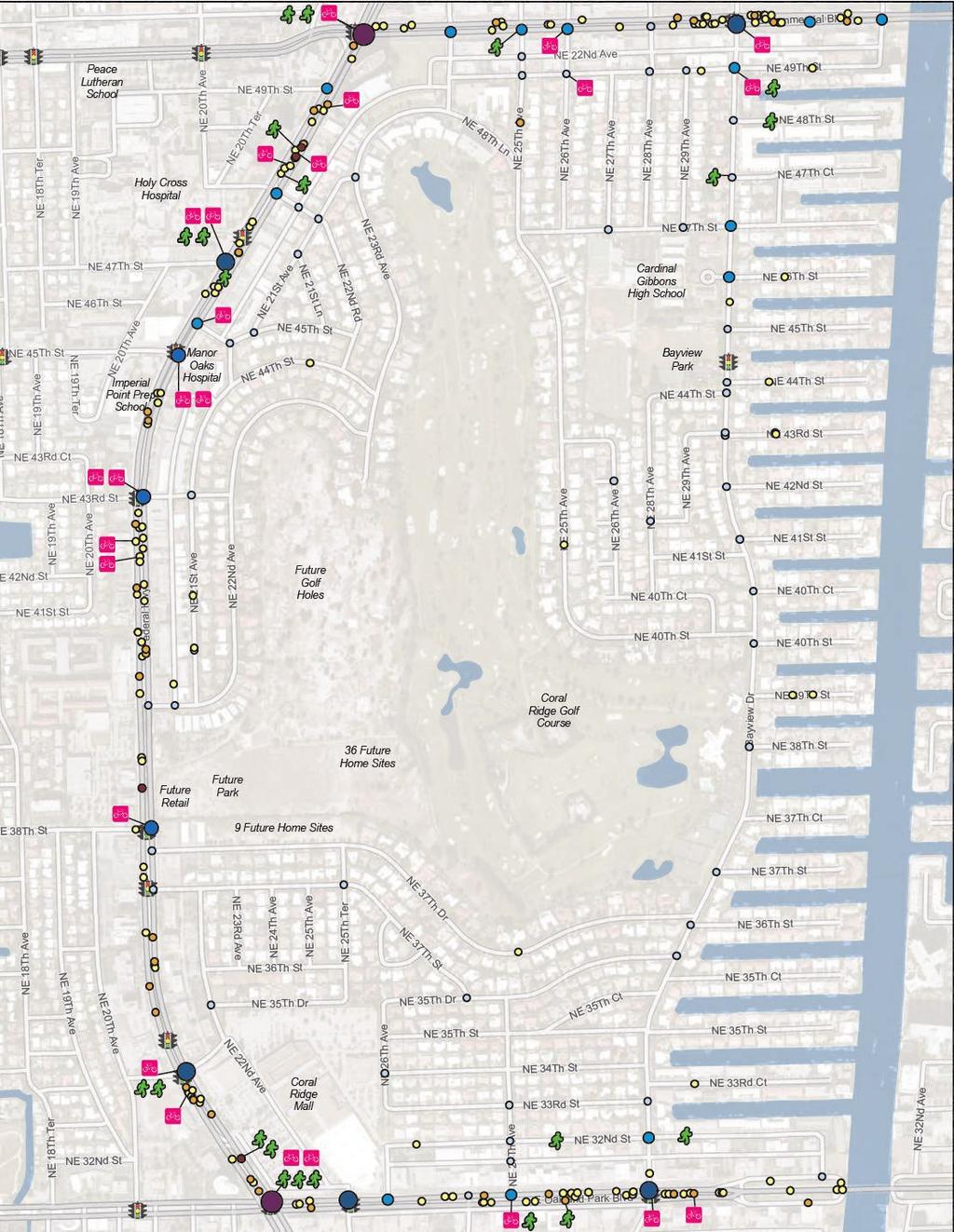
72 Coral Ridge Country Club Neighborhood Mobility Masterplan 72 SPEED AND VOLUME COUNT LOCATIONS Feet 1,000
73 73
74 74
75 APPENDIX PLANNING LEVEL PRIORITIZATION SCORINGC 75
76 PRIORITIZATION CRITERIA, WEIGHT, AND THRESHOLDS TABLE 21. PRIORITIZATION CRITERIA, WEIGHTS, AND THRESHOLDS 76 Coral Ridge Country Club Neighborhood Mobility Masterplan MEASURE PROJECT BENEFITS 1 Anticipated improvement in pedestrian/bicyclist safety 2 Anticipated safety benefit to segment with history of fatal or severe injury pedestrian and bicycle crashes 3 Support of regional transit services and/or premium transit services WEIGHT BENEFIT CATEGORIES DESCRIPTION THRESHOLDS 2 Safety Project type typically improves pedestrian and bicyclist safety. 2 Safety Based on most recent crash maps 3 Travel Choices, Sustainability 4 Enhancement of transit stops 1 Travel Choices, Sustainability 5 Closure of sidewalk network gaps 5 Connectivity, Safety, Travel Choices, Health Benefits 6 Closure of bicycle network gaps 5 Connectivity, Safety, 7 Improvement of street crossings for non-automobile modes Travel Choices, Health Benefits 3 Connectivity, Safety, Travel Choices, Health Benefits 8 Support of active transportation 5 Quality of Life, 9 Improvement of multimodal system quality 10 Incorporation of sustainability elements to adapt to climate change PROJECT FEASIBILITY 11 Opportunity to qualify for federal or other funding 12 Freedom from obstacles to implementation Sustainability, Economic Benefit 4 Quality of Life, Travel Choices, Economic Benefit 4 Sustainability, Safety, Connectivity for City of Fort Lauderdale. Planned premium transit services shown in the LRTP are in the corridor. Project creates space for enhanced transit stops (e.g., sidewalk buffer) New sidewalks constructed to close gaps and make new connections. New bicycle facilities constructed to close gaps and make new connections. Project enhances street crossings. Project improves areas with high Active Transportation Demand Scores Project adds pedestrian-scale lighting, shade, buffers, and other quality elements Project adds stormwater management, shade, LED lighting, and drought resistant features. 1 N/A Corridor study and/or livability study involving multiple jurisdictions and/or agencies 5 N/A Timeline, agency approvals, need for land acquisition, contract capacity, etc. 13 Community support 5 N/A Consistency with the Multimodal Connectivity Map Minimal Moderate Substantial Minimal Moderate Substantial Minimal Moderate Substantial Minimal Moderate Substantial Minimal Moderate Substantial Minimal Moderate Substantial Minimal Moderate Substantial Minimal Moderate Substantial Minimal Moderate Substantial Minimal Moderate Substantial Minimal Moderate Substantial Minimal Moderate Substantial Minimal Moderate Substantial POINTS
77 Details of the Project Benefits criteria in TABLE 21 and the proposed scoring procedure are as follows: Anticipated improvement in pedestrian/ bicyclist safety. Crossing enhancements score a 1. Projects that reduce crossing distance score a 2. Projects that separate bicyclists from automobiles score a 2. (The Highway Safety Manual (HSM) indicates that these project types tend to improve pedestrian/ bicyclist safety.) Anticipated improvement to segment with history of fatal or severe injury pedestrian/ bicycle crashes. This applies only to segments with a history of fatal or severe injury pedestrian/bicycle crashes. Projects that create separation between pedestrians and automobiles or between bicyclists and automobiles score a 2. Other project types that the HSM indicates tend to improve pedestrian/bicyclist safety score a 1. Support of regional and premium transit services. Projects that create new regional and premium transit services score a 2. Projects that enhance existing regional and premium transit services score a 1. This also applies to pedestrian/bicycle projects that are within 1/4 mile of The Wave and Tri-Rail. Projects that create pedestrian/bicycle connections to The Wave and Tri-Rail score a 2. Projects that enhance existing pedestrian/bicycle connections to The Wave and Tri-Rail score a 1. Enhances transit stops. Projects that add a sidewalk buffer score a 1. Projects that add bus stop amenities score a 2. Closure of sidewalk network gaps. Projects that complete existing sidewalks score a 1. Projects that construct more extensive, new sidewalks score a 2. Closure of bicycle network gaps. Projects that complete existing bicycle facilities score a 1. Projects that construct more extensive, new bicycle lanes score a 2. Projects that add sharrows score a 1. Improves street crossings for non-automobile modes. Projects that include 1-2 crossing enhancements score a 1. Projects that include 3 or more crossing enhancements score a 2. Supports active transportation. Projects that serve Census tracts ranked in the top 1-10 for Active Transportation Demand score a 2. Projects in the top score a 1.2. (Active Transportation Demand Score is an index developed by the City of Portland, Oregon, for use in prioritizing multimodal projects. It accounts for population density, business density, percent of population less than 17 years old, percent of population greater than or equal to 65 years old, percent of population that is non-white, percent of households below the poverty line, and percent of households with no access to an automobile. These demographic characteristics are traditionally tied to propensity to travel by non-automobile modes. Improves multimodal system quality. Projects that add 3-4 of sidewalk buffers, bicycle lane buffers, pedestrian-scale lighting, and shade score a 2. Projects that add 1-2 of those elements score a 1. Incorporation of sustainability elements to adapt to climate change. Projects that add 3-4 of stormwater management, shade, LED lighting, and drought resistant features score a 2. Projects that add 1-2 of those elements score a 1. Details of the Project Feasibility criteria in TABLE 21 and the proposed scoring procedure are as follows: Opportunity to qualify for federal or other funding. Projects score a 1 if they are located in a major corridor, are located in corridors that affect multiple jurisdictions, or are livability projects. Projects score a 2 if they are consistent with projects identified in the CIP, Transportation Improvement Program (TIP), or LRTP. Freedom from implementation obstacles. Projects on State and County roads score a 1. Projects on City roads score a 2. Community support. Projects consistent with the previously supported neighborhood plans (which were created with public input) score a 1. Projects consistent with the City Commission approved Neighborhood or Master Plans score a Coral Ridge Country Club Neighborhood Mobility Masterplan
78 INTERSECTION IMPROVEMENTS - INTERNAL STREETS Location Treatment Reason Bayview Dr & NE 32Nd St Roundabout Traffic Calming Bayview Dr & Burning Tree Drive (NW 35th Ct) Roundabout Traffic Calming Bayview Dr & NE 37Th Dr Roundabout Traffic Calming Bayview Dr & NE 40Th St Roundabout Traffic Calming Bayview Dr & NE 44Th St Move midblock signal to this intersection; add crossing Pedestrian Access Bayview Dr & NE 47Th St Roundabout Traffic Calming Bayview Dr & NE 49Th St Roundabout Traffic Calming and Neighborhood Gateway NE 21st Ave & NE 21st Ln Mini Roundabout Traffic Calming NE 21St Ave & NE 22Nd Rd & NE 48Th St Mini Roundabout Traffic Calming and Neighborhood Gateway NE 21St Ave & NE 23Rd Ave Tighten curb radii Traffic Calming 78 Coral Ridge Country Club Neighborhood Mobility Masterplan NE 21St Ave & NE 24Th Terrace & NE 48Th Ln Raised Intersection Pedestrian Access NE 21St Ave & NE 43Rd St Mini Roundabout Traffic Calming and Neighborhood Gateway NE 21st Ave & NE 44th St Mini Roundabout Traffic Calming NE 21St Ave & NE 45Th St (E) Pocket Park and Tighten Curb Radius (both sides) Traffic Calming, recreation area NE 21St Ave & NE 45Th St (W) Mini Roundabout Traffic Calming and Neighborhood Gateway NE 22Nd Ave & NE 33Rd St Mini Roundabout Traffic Calming NE 22Nd Ave & NE 37Th St Mini Roundabout Traffic Calming and Neighborhood Gateway NE 24Th Terrace & NE 49Th St Raised Intersection High ped and bike activity, Traffic Calming NE 25Th Ave & NE 47Th St Mini Roundabout Traffic Calming NE 25Th Ave & NE 48Th Ln Mini Roundabout Traffic Calming NE 25Th Ave & NE 49Th St Mini Roundabout High ped and bike activity, Traffic Calming NE 25Th Terrace & NE 35Th Dr New secured pedestrian access to Coral Ridge Mall Pedestrian Access NE 25Th Terrace & NE 37Th Drive Mini Roundabout Traffic Calming NE 25Th Terrace & NE 37Th St Mini Roundabout Traffic Calming NE 26Th Ave & NE 35Th St New secured pedestrian access to Coral Ridge Mall Pedestrian Access NE 27Th Ave & NE 32Nd St Mini Roundabout Traffic Calming NE 27Th Ave & NE 33Rd St Mini Roundabout Traffic Calming NE 27Th Ave & NE 34Th St Mini Roundabout Traffic Calming NE 27Th Ave & NE 35Th Dr Mini Roundabout Traffic Calming NE 27Th Ave & NE 35Th St Mini Roundabout Traffic Calming NE 28Th Ave & NE 47Th St Raised Intersection Traffic Calming NE 28th Ave & NE 49th St Mini Roundabout Traffic Calming NE 35Th Ct & Burning Tree Drive (NE 35Th St) Pocket Park and Tighten Curb Radius (both sides) Traffic Calming, Recreation Area NE 35Th Dr & NE 37Th St Tighten curb radii (90* intersection) Traffic Calming NE 28th Ave & NE 44th St Tighten turning radii closer to 90* Traffic Calming NE 37th Drive east of Federal Highway Gateway Treatment Traffic Calming, Neighborhood Gateway NE 37th Street east of Federal Highway Gateway Treatment Traffic Calming, Neighborhood Gateway NE 43rd Street east of Federal Highway Gateway Treatment Traffic Calming, Neighborhood Gateway
79 Measure Comments Prioritization Score * The signal should be pedestrian actuated Need to do so with landscaping and reduced pavement Driveway Need to address the circular drive access to roundabout Needs to have a traversable median for back out parking Need to address parking on NW lot Coordinate with mall owners Coordinate with mall owners There is a circular driveway on the northeast corner that needs to be addressed. Options are to have it exit to 35th Drive or create a P shaped driveway *Note: Measure 10 not reviewed because these features can vary and should be determined in design. It is encouraged that sustainable features be incorporated into each improvement to the extent possible. 79 Coral Ridge Country Club Neighborhood Mobility Masterplan
80 INTERSECTION IMPROVEMENTS - EXTERNAL STREETS Location Treatment Reason Federal Hwy & Coral Ridge Mall Entrance New Signalized Pedestrian Crossing Access to bus stops and destinations Federal Hwy & NE 33Rd St Complete Pedestrian Crossing (Southern Leg) Pedestrian Access Federal Hwy & NE 37Th St New Signalized Pedestrian Crossing Access to bus stops and destinations Federal Hwy & NE 38Th St Complete Pedestrian Crossing (Southern Leg) Pedestrian Access Federal Hwy Between NE 48th St & 49th St New Signalized Pedestrian Crossing Access to bus stops and destinations NE 25Th Ave & Commercial Blvd New Signalized Pedestrian Crossing Access to bus stops and destinations NE 27Th Ave & Oakland Park Blvd New Signalized Pedestrian Crossing Access to bus stops and destinations Federal Hwy and Commercial Blvd (SW Corner) Remove Channelized Right Turn Lane Traffic Calming; Ped/Bike Comfort Federal Hwy and Commercial Blvd (NE Corner) Remove Channelized Right Turn Lane Traffic Calming; Ped/Bike Comfort BCT Stop 865 Move stop N of NE 47th Street Bring stop closer to pedestrian crossing BCT Stop 4419 Move stop north of new signal (if signalized) Pedestrian crossing will be on north side Coral Ridge Country Club Neighborhood Mobility Masterplan 80
81 Comments Prioritization Score Measure * Requires signalization; FDOT Roadway Already signalized; just need to add crosswalks Requires signalization; FDOT Roadway Requires signalization; FDOT Roadway Requires signalization; FDOT Roadway FDOT Roadway; requires more analysis FDOT Roadway; requires more analysis Need to coordinate with BCT & Analyze feasibility Need to coordinate with BCT & Analyze feasibility *Note: Measure 10 not reviewed because these features can vary and should be determined in design. It is encouraged that sustainable features be incorporated into each improvement to the extent possible. Coral Ridge Country Club Neighborhood Mobility Masterplan 81
82 SEGMENT IMPROVEMENTS - INTERNAL STREETS Street From To Treatment Reason Bayview Drive Oakland Park Blvd Commercial Blvd Sidewalks on Both Sides Connectivity Bayview Drive Oakland Park Blvd Commercial Blvd Landscaped Medians Traffic Calming Bayview Drive Oakland Park Blvd Commercial Blvd Paint Bicycle Lanes Connectivity NE 21st Ave NE 39th St NE 24th Terrace Sidewalk on east side Connectivity NE 21st Ave NE 37th Street NE 39th Street Pedestrian connection Connectivity NE 21st Ave NE 23rd Ave NE 24th Terrace Mini Median Island (2) Traffic calming NE 21st Ave NE 23rd Ave End of sidewalk on west side Sidewalk on West Side Connectivity NE 22nd Ave Federal Hwy NE 37th Street Sidewalk on West Side Connectivity NE 22nd Ave NE 33rd St NE 35th Drive Mini Median Island Traffic calming NE 22nd Ave NE 35th Drive NE 36th St Mini Median Island Traffic calming NE 25th Ave Bayview Drive Commercial Blvd Sidewalk on west side Connectivity 82 Coral Ridge Country Club Neighborhood Mobility Masterplan NE 25th Terrace NE 35th Drive NE 37th Drive Sidewalk on East Side Connectivity NE 26th Ave Mall Access NE 35th Drive Sidewalk on West Side Connectivity NE 27th Ave Oakland Park Blvd NE 35th Drive Sidewalk on east side Connectivity NE 28th Ave NE 47th Street Commercial Blvd Sidewalk on east side Connectivity NE 32nd Street NE 25th Ave Bayview Drive Sidewalk on North Side Connectivity NE 35th Drive NE 27th Ave Bayview Drive Lateral Shift Traffic Calming NE 35th Drive NE 26th Ave Bayview Drive Sidewalk on North Side Connectivity NE 35th Drive NE 25th Terrace NE 35th Drive New Pedestrian Access Connectivity NE 37th Drive Federal Hwy Bayview Drive Lateral Shift Traffic calming NE 37th Street Federal Hwy NE 35th Drive Sidewalk on North Side Connectivity NE 37th Street NE 22nd Ave NE 23rd Ave Mini Median Island Traffic Calming NE 37th Street NE 24th Ave NE 25thAve Mini Median Island Traffic Calming NE 37th Street NE 25th Terrace NE 35th Drive Lateral Shift Traffic Calming NE 39th St Federal Hwy NE 21st Ave Sidewalk on South Side Connectivity NE 43rd St Federal Hwy NE 21st Ave Sidewalk on South Side Connectivity NE 45th St Alley NE 21st Ave Sidewalk on North Side Connectivity NE 47th Street NE 25th Ave Bayview Drive Sidewalk on South Side Connectivity NE 48th Ln NE 24th Terrace NE 25th Ave Mini Median Island Traffic calming NE 48th Ln NE 24th Terrace NE 25th Ave Sidewalk on South Side Connectivity NE 48th St Alley NE 21st Ave Sidewalk on North Side Connectivity NE 49th Street NE 24th Terrace Bayview Drive Sidewalks on South Side Connectivity NE 49th Street NE 24th Terrace NE 25th Ave Mini Median Island Traffic Calming NE 49th Street NE 26th Ave NE 27th Ave Mini Median Island Traffic Calming NE 49th Street NE 28th Ave NE 29th Ave Mini Median Island Traffic Calming NE 21st Street NE 39th Street NE 29th Terrace Paint Sharrows Connectivity NE 24th Terrace NE 21st Street NE 49th Street Paint Sharrows Connectivity NE 49th Street NE 24th Terrace Commercial Blvd Paint Sharrows Connectivity
83 Potential Issues Priority Score Measure * Consider driveway access Need to resolve access issues Head in parking needs to be removed from surrounding developments Head in parking needs to be removed from surrounding developments Head in parking needs to be removed from surrounding developments Coral Ridge Country Club Neighborhood Mobility Masterplan *Note: Measure 10 not reviewed because these features can vary and should be determined in design. It is encouraged that sustainable features be incorporated into each improvement to the extent possible.
84 SEGMENT IMPROVEMENTS - EXTERNAL STREETS Street From To Treatment Reason Oakland Park Blvd Federal Highway Beach Add bicycle Lanes (buffered if possible) Oakland Park Blvd Federal Highway Beach Add 8-10 Sidewalks Where Missing Oakland Park Blvd Federal Highway Beach Widen sidewalks to 8-10 Where Narrower Federal Highway Oakland Park Blvd Commercial Blvd Add bicycle Lanes (buffered if possible) Federal Highway Oakland Park Blvd Commercial Blvd Add 8-10 Sidewalks Where Missing Federal Highway Oakland Park Blvd Commercial Blvd Widen sidewalks to 8-10 Where Narrower Commercial Blvd Federal Highway Beach Add bicycle Lanes (buffered if possible) Commercial Blvd Federal Highway Beach Add 8-10 Sidewalks Where Missing Commercial Blvd Federal Highway Beach Widen sidewalks to 8-10 Where Narrower Connectivity Connectivity Ped/Bike Comfort Connectivity Connectivity Ped/Bike Comfort Connectivity Connectivity Ped/Bike Comfort Coral Ridge Country Club Neighborhood Mobility Masterplan 84
85 Measure Potential Issues Priority Score * Right of Way, FDOT Roadway Right of Way, FDOT Roadway Right of Way, FDOT Roadway *Note: Measure 10 not reviewed because these features can vary and should be determined in design. It is encouraged that sustainable features be incorporated into each improvement to the extent possible. Coral Ridge Country Club Neighborhood Mobility Masterplan 85

86 86
CONNECTING PEOPLE TO PLACES
 CONNECTING PEOPLE TO PLACES 82 EAST BENCH MASTER PLAN 07 Introduction The East Bench transportation system is a collection of slow moving, treelined residential streets and major arteries that are the
Complete Street Analysis of a Road Diet: Orange Grove Boulevard, Pasadena, CA
 Complete Street Analysis of a Road Diet: Orange Grove Boulevard, Pasadena, CA Aaron Elias, Bill Cisco Abstract As part of evaluating the feasibility of a road diet on Orange Grove Boulevard in Pasadena,
2014/2015 BIKE ROUTE PLAN 83 AVENUE PROTECTED BIKE LANE
 About the Project The City of Edmonton is planning a major bike route on the southside of Edmonton. The Strathcona Bike Route will connect the communities of Strathcona, Garneau and the University area,
City of Elizabeth City Neighborhood Traffic Calming Policy and Guidelines
 City of Elizabeth City Neighborhood Traffic Calming Policy and Guidelines I. Purpose: The City of Elizabeth City is committed to ensure the overall safety and livability of residential neighborhoods. One
Agenda. Overview PRINCE GEORGE S PLAZA METRO AREA PEDESTRIAN PLAN
 PRINCE GEORGE S PLAZA METRO AREA PEDESTRIAN PLAN May 28, 2008 Agenda Welcome and introductions Project overview and issue identification Planning context and strengths Design challenges and initial recommendations
2014/2015 BIKE ROUTE PLAN 83 AVENUE PROTECTED BIKE LANE
 About the Project 2014/2015 BIKE ROUTE PLAN The City of Edmonton is planning a major bike route on the south side of Edmonton. This bike route is one part of a plan to provide citizens with transportation
City of Novi Non-Motorized Master Plan 2011 Executive Summary
 City of Novi Non-Motorized Master Plan 2011 Executive Summary Prepared by: February 28, 2011 Why Plan? Encouraging healthy, active lifestyles through pathway and sidewalk connectivity has been a focus
Chapter 2: Standards for Access, Non-Motorized, and Transit
 Standards for Access, Non-Motorized, and Transit Chapter 2: Standards for Access, Non-Motorized, and Transit The Washtenaw County Access Management Plan was developed based on the analysis of existing
US 41 COMPLETE STREETS CORRIDOR PLANNING STUDY from University Parkway to Whitfield Avenue
 41 US 41 COMPLETE STREETS CORRIDOR PLANNING STUDY from University Parkway to Whitfield Avenue EXECUTIVE SUMMARY DRAFT FEBRUARY 2019 Project Overview The US 41 Complete Streets Corridor Planning Study,
WELCOME Public Information Centre
 WELCOME Public Information Centre Fernforest Drive Brampton Soccer Centre Community Room #2 Tuesday January 19, 2016 6:30 p.m.to 9:00 p.m. Please sign in Neighbourhood Traffic Calming Guide Background
Tonight is for you. Learn everything you can. Share all your ideas.
 Strathcona Neighbourhood Renewal Draft Concept Design Tonight is for you. Learn everything you can. Share all your ideas. What is Neighbourhood Renewal? Creating a design with you for your neighbourhood.
BETHEL ROAD AND SEDGWICK ROAD CORRIDOR STUDY
 DRAFT PLAN City Council Meeting August 14, 2017 STUDY AREA Sedgwick Corridor State Route 160, principal arterial with Class 3 access management designation, commuter and freight route, connection to SR
Broad Street Bicycle Boulevard Design Guidelines
 Broad Street Bicycle Boulevard Design Guidelines Building from the strategies introduced in the 2013 Bicycle Transportation Plan and community input received thus far, City Transportation Staff have identified
TRAFFIC IMPACT ANALYSIS
 TRAFFIC IMPACT ANALYSIS FOR THE CHAMPAIGN UNIT#4 SCHOOL DISTRICT PROPOSED HIGH SCHOOL (SPALDING PARK SITE) IN THE CITY OF CHAMPAIGN Final Report Champaign Urbana Urbanized Area Transportation Study 6/24/2014
CONNECTIVITY PLAN. Adopted December 5, 2017 City of Virginia Beach
 CONNECTIVITY PLAN Adopted December 5, 2017 City of Virginia Beach CONTENTS 1.0 Background & Purpose... 2 2.0 Existing Inventory & Analysis... 3 ViBe District Existing Walking Conditions... 4 3.0 ViBe District
City of Margate, Florida. Neighborhood Traffic Management Manual
 City of Margate, Florida Neighborhood Traffic Management Manual Table of Contents Page No. I. INTRODUCTION... 1 II. TRAFFIC CALMING REQUEST AND PROCESSING PROCEDURES... 2 1. COMPLETE AND SUBMIT PROJECT
Access Management in the Vicinity of Intersections
 Access Management in the Vicinity of Intersections FHWA-SA-10-002 Technical Summary Photo: Ralph Bentley (used with permission) 0 Access Management is: The design, implementation and management of entry
Multimodal Through Corridors and Placemaking Corridors
 68 Multimodal Through Corridors and Placemaking Corridors Corridors have different functions in a region. Some corridors are used to get smoothly and rapidly through a region or to get quickly to major
REGIONAL BICYCLE AND PEDESTRIAN DESIGN GUIDELINES
 REGIONAL BICYCLE AND PEDESTRIAN DESIGN GUIDELINES November 16, 2011 Deb Humphreys North Central Texas Council of Governments Bicycle and Pedestrian Advisory Committee Snapshot of the Guide 1. Introduction
Goodlettsville Bicycle and Pedestrian Plan Executive Summary
 Goodlettsville Bicycle and Pedestrian Plan July 2010 In Cooperation with the Nashville Area Metropolitan Planning Executive Organization Summary Introduction Progressive and forward thinking communities
Dr. M.L. King, Jr. Street North Complete Streets Resurfacing Opportunities HOUSING, LAND USE, AND TRANSPORTATION COMMITTEE MARCH 22, 2018
 Dr. M.L. King, Jr. Street North Complete Streets Resurfacing Opportunities HOUSING, LAND USE, AND TRANSPORTATION COMMITTEE MARCH 22, 2018 What s Happening The City plans to mill and resurface Dr. M.L.
Vision: Traditional hamlet with an attractive business/pedestrian friendly main street connected to adjacent walkable neighborhoods
 N D. Focus Area II Vision: Traditional hamlet with an attractive business/pedestrian friendly main street connected to adjacent walkable neighborhoods Transit Road Focus Area II is located in the Hamlet
Solana Beach Comprehensive Active Transportation Strategy (CATS)
") Solana Beach Comprehensive Active Transportation Strategy (CATS) 3.0 Goals & Policies The Solana Beach CATS goals and objectives outlined below were largely drawn from the Solana Beach Circulation Element
Solana Beach Comprehensive Active Transportation Strategy (CATS) 3.0 Goals & Policies The Solana Beach CATS goals and objectives outlined below were largely drawn from the Solana Beach Circulation Element
PRINCE GEORGE S PLAZA METRO AREA PEDESTRIAN PLAN
 PRINCE GEORGE S PLAZA METRO AREA PEDESTRIAN PLAN May 28, 2008 Agenda Welcome and introductions Project overview and issue identification Planning context and strengths Design challenges and initial recommendations
5 CIRCULATION AND STREET DESIGN
 5 CIRCULATION AND STREET DESIGN This chapter describes circulation and streetscape improvements proposed for the Northwest Chico Specific Plan Area. It includes detailed design specifications for existing
Report. Typical Sections. City of Middleton, WI
 Report Typical Sections City of Middleton, WI December 2006 Report for City of Middleton, Wisconsin Typical Sections repared by: Traffic Associates LLC and STRAND ASSOCIATES, INC. 910 West Wingra Drive
Appendix A: Crosswalk Policy
 Appendix A: Crosswalk Policy Appendix A: Crosswalk Policy Introduction This citywide Crosswalk Policy is aimed at improving pedestrian safety and enhancing pedestrian mobility by providing a framework
Bicycle Facilities Planning
 Bicycle Facilities Planning Overview Types of Cyclists Purpose for Riding Types of Facilities Bike Lanes Bicycle Boulevards Cycle Tracks Intersections Signals Signing and Marking Discussion Types of Bicyclists
Bikeway action plan. Bicycle Friendly Community Workshop March 5, 2007 Rochester, MN
 Bikeway action plan Summary The was held on March 5, 2007 at the Rochester Mayo Civic Center. The workshop was hosted by Rochester-Olmsted County Planning Department in collaboration with the League of
APPENDIX 2 LAKESHORE ROAD TRANSPORTATION REVIEW STUDY EXECUTIVE SUMMARY
 APPENDIX 2 LAKESHORE ROAD TRANSPORTATION REVIEW STUDY EXECUTIVE SUMMARY Appendix 2 City of Mississauga Lakeshore Road FINAL REPORT Transportation Review Study December 2010 EXECUTIVE SUMMARY Study Purpose
CITY OF COCOA BEACH 2025 COMPREHENSIVE PLAN. Section VIII Mobility Element Goals, Objectives, and Policies
 CITY OF COCOA BEACH 2025 COMPREHENSIVE PLAN Section VIII Mobility Element Goals, Objectives, and Policies Adopted August 6, 2015 by Ordinance No. 1591 VIII MOBILITY ELEMENT Table of Contents Page Number
City of Charlottesville Bicycle and Pedestrian Master Plan Update
 City of Charlottesville Bicycle and Pedestrian Master Plan Update September 17, 2014 I. Welcome and meeting overview II. Project status update III. Network overview IV. Break-out groups Pedestrian Network
5.0 Roadway System Plan
 Southwest Boise Transportation Study Page 16 5.0 Roadway System Plan The Roadway System Plan outlines roadway improvements in the Initial Study Area. It forecasts future deficiencies on the arterial system,
Off-road Trails. Guidance
 Off-road Trails Off-road trails are shared use paths located on an independent alignment that provide two-way travel for people walking, bicycling, and other non-motorized users. Trails specifically along
complete streets design and construction standards public primer City of Edmonton
 complete streets design and construction standards public primer City of Edmonton introduction Complete Streets are streets for everyone: people who walk, wheel, bike, take transit, or drive. They are
Public Information Centre
 WELCOME Public Information Centre Father Tobin Road Lougheed Middle School - Library Wednesday November 7, 2012 7:00 p.m.to 9:00 p.m. Please sign in Neighbourhood Traffic Calming Guide Background The City
City of Seattle Edward B. Murray, Mayor
 City of Seattle Edward B. Murray, Mayor Department of Transportation Scott Kubly, Director Eastlake Community Council 117 E Louisa St. #1 Seattle, WA 98102-3278 January 28, 2016 RE: Roosevelt to Downtown
MASTER BICYCLE AND PEDESTRIAN PLAN
 VILLAGE OF NORTHBROOK MASTER BICYCLE AND PEDESTRIAN PLAN DRAFT PLAN OPEN HOUSE May 2, 2018 AGENDA 1. Community Engagement 2. Vision and Goals 3. General Structure of Plan 4. Recommendations Overview 5.
PEDESTRIAN ACTION PLAN
 ATTACHMENT 2 CITY OF SANTA MONICA PEDESTRIAN ACTION PLAN CITY OF SANTA MONICA PEDESTRIAN ACTION PLAN This page intentionally left blank EXECUTIVE SUMMARY CHAPTER 1 EXECUTIVE SUMMARY Setting the Stage
Safe Streets. City of Lake Forest Park. March 21, 2017
 Safe Streets City of Lake Forest Park March 21, 2017 1 01 WELCOME 2 Agenda WELCOME WHAT IS THIS PROJECT? CONTEXT DRAFT CITYWIDE PROJECTS EXERCISE INTRODUCTION 3 02 WHAT IS THIS PROJECT? 4 WHAT IS THIS
TRANSPORTATION NEEDS ASSESSMENT
 TRANSPORTATION NEEDS ASSESSMENT A travel demand analysis was carried out to determine the operational issues and the potential benefit that adding traffic capacity would have on the road network. All the
CITY OF WEST LAKE HILLS. Forest View Neighborhood Traffic Calming Study
 CITY OF WEST LAKE HILLS 901 South Mopac Expressway Building V, Suite 220 Austin, Texas 78746 Texas P.E. Firm Registration No. F-929 Klotz Associates Final Report Submittal: March 20, 2015 Revised Final
City of Wayzata Comprehensive Plan 2030 Transportation Chapter: Appendix A
 A1. Functional Classification Table A-1 illustrates the Metropolitan Council s detailed criteria established for the functional classification of roadways within the Twin Cities Metropolitan Area. Table
NEIGHBORHOOD TRAFFIC CALMING POLICY
 NEIGHBORHOOD TRAFFIC CALMING POLICY I. PURPOSE The City of Kent continually strives to strengthen and protect its neighborhoods by improving the quality of life in residential areas. Traffic conditions
HARRISON STREET/OAKLAND AVENUE COMMUNITY TRANSPORTATION PLAN
 HARRISON STREET/OAKLAND AVENUE Community Workshop #4: Draft Plan Review December 3, 2009 D E S I G N, C O M M U N I T Y & E N V I R O N M E N T INTRODUCTIONS Key Project Staff: Alisa Shen, Project Manager,
APPENDIX A: Complete Streets Checklist DRAFT NOVEMBER 2016
 APPENDIX A: Complete Streets Checklist DRAFT NOVEMBER 2016 Complete Streets Checklist MetroPlan Orlando s Complete Streets Checklist is an internal planning tool for staff to further implementation of
Edenbrook Hill Drive Traffic Calming Study
 WELCOME Public Information Centre Edenbrook Hill Drive Traffic Calming Study Fletchers Meadow Secondary School Wednesday January 20, 2016 6:30 p.m.to 9:00 p.m. Please sign in Neighbourhood Traffic Calming
Residential Traffic Calming Program Guide. Town of Ashland, Virginia
 Residential Traffic Calming Program Guide Town of Ashland, Virginia August 1, 2006 TABLE OF CONTENTS A. INTRODUCTION... 1 B. GOALS... 1 C. CRITERIA... 1 D. IDENTIFYING NEIGHBORHOOD TRAFFIC CONCERNS...
TRAFFIC CALMING GUIDE FOR TORONTO CITY OF TORONTO TRANSPORTATION SERVICES DIVISION
 TRAFFIC CALMING GUIDE FOR TORONTO CITY OF TORONTO TRANSPORTATION SERVICES DIVISION CITY OF TORONTO TRANSPORTATION SERVICES DIVISION 2016 TRAFFIC CALMING GUIDE FOR TORONTO TABLE OF CONTENTS Introduction
Community Transportation Plan
 Community Transportation Plan Appendix A: Traffic Calming CITY OF DECATUR COMMUNITY TRANSPORTATION PLAN Appendix A: City of Decatur City-wide Residential Traffic Calming Program Process & Procedures The
COWETA HIGH SCHOOL AND EAST HIGHWAY 51
 COWETA HIGH SCHOOL AND EAST HIGHWAY 51 Lack of sidewalks along Ben Lumpkin Rd. Lack of crosswalks and ramps at intersection. Hwy 51 is wide to cross as a pedestrian. No ADA compliance or connection to
Bridgewater Complete Streets Prioritization Plan and Pedestrian Safety Assessment
 Bridgewater Complete Streets Prioritization Plan and Pedestrian Safety Assessment Presented by Luciano Rabito Manager of Complete Streets Presented to Bridgewater, MA Wednesday, April 26, 2017 6:30 P.M.
NM-POLICY 1: Improve service levels, participation, and options for non-motorized transportation modes throughout the County.
 Transportation PRINCE WILLIAM COUNTY 2008 COMPREHENSIVE PLAN NON-MOTORIZED PLAN CONTENTS Goals, Policies, and Action Strategies Table 4 (Bike Facility Classifications and Descriptions) Table 5 (Bike Facility
Bay to Bay Boulevard Complete Streets Project
 Bay to Bay Boulevard Complete Streets Project Dale Mabry Highway to Bayshore Boulevard February 08, 2018 Photo Source: Tampa Bay Times Alessandra Da Pra Meeting Format Introduction Resurfacing Information
Duwamish Way-finding and CTR Report
 V. North Tukwila When the North Tukwila Manufacturing and Industrial Center was designated in 1992 as part of the region s land use and transportation plan, the plan called for the area to set a light-rail
Lee s Summit Road Improvement Study Public Open House June 7, 2007 Summary of Comment Card Responses
 Lee s Summit Road Improvement Study Public Open House June 7, 2007 Summary of Comment Card Responses Introduction At the Lee s Summit Road Improvement Study Public Open House held Thursday, June 7, 2007
RESOLUTION NO ?? A RESOLUTION OF THE CITY OF NEPTUNE BEACH ADOPTING A COMPLETE STREETS POLICY
 RESOLUTION NO. 2018-?? A RESOLUTION OF THE CITY OF NEPTUNE BEACH ADOPTING A COMPLETE STREETS POLICY WHEREAS, safe, convenient, and accessible transportation for all users is a priority of the City of Neptune
Coquitlam Cross-town Bike Route Improving Bicycle Facilities in a Mature Suburban Environment
 Coquitlam Cross-town Bike Route Improving Bicycle Facilities in a Mature Suburban Environment Sarah Rocchi, Vice-President, Projects, Opus International Consultants (Main Presenter) Catherine Mohoruk,
City of Wilsonville 5 th Street to Kinsman Road Extension Project
 City of Wilsonville 5 th Street to Kinsman Road Walking Tour & Neighborhood Workshop Summary Report Public Outreach Overview On July 18 th, 2017, the City of Wilsonville hosted a neighborhood walking tour
Executive Summary Route 30 Corridor Master Plan
 Route Corridor Master Plan Project Overview The Route Corridor Master Plan is a coordinated multimodal transportation and land use plan for the entire stretch of Route through East Whiteland Township,
Welcome! San Jose Avenue Open House August 25, 2015
 Welcome! San Jose Avenue Open House August 25, 2015 Vision Zero The City and County of San Francisco adopted Vision Zero San Francisco Vision Zero High Injury Network as a policy in 2014, committing an
MEMORANDUM. Charlotte Fleetwood, Transportation Planner
 MEMORANDUM Date: Updated August 22, 2017 To: Organization: Charlotte Fleetwood, Transportation Planner Boston Transportation Department From: Jason DeGray, P.E., PTOE, Regional Director of Engineering
DEPARTMENT OF ENVIRONMENTAL SERVICES. North Harrison Street (Lee Highway to Little Falls Road) Comparative Analysis. Prepared for:
 Comparative Analysis. Prepared for:") DEPARTMENT OF ENVIRONMENTAL SERVICES North Harrison Street (Lee Highway to Little Falls Road) Comparative Analysis Prepared for: Arlington County Department of Environmental Services 2100 Clarendon Boulevard,
DEPARTMENT OF ENVIRONMENTAL SERVICES North Harrison Street (Lee Highway to Little Falls Road) Comparative Analysis Prepared for: Arlington County Department of Environmental Services 2100 Clarendon Boulevard,
Plant City Walk-Bike Plan
 Plant City Walk-Bike Plan Plant City Commute Mode Share 2.2% 1.4% 2.9% Drove alone 10.2% Carpooled Public transportation (0.1%) Walked Used a Bike (0.4%) 82.9% Taxicab, motorcycle, or other means Worked
Albany Shaker Road Corridor Study Public Meeting # 2
 Albany Shaker Road Corridor Study Public Meeting # 2 Scope / Meeting Purpose This project is a CDTC Linkage Study. The Linkage Program is designed to implement the adopted planning and investment principles
EXECUTIVE SUMMARY. Vision
 Vision Walking and bicycling in Salt Lake City will be safe, convenient, comfortable, and viable transportation options that connect people to places, foster recreational and economic development opportunities,
Illustrated Principles of Good Planning
 Illustrated Principles of Good Planning The Miami 21 Zoning Code incorporates time-tested planning principles into the zoning regulations of our City. These are principles that make for better neighborhoods,
CONTENTS EXECUTIVE SUMMARY 1
 CONTENTS CHAPTER PAGE EXECUTIVE SUMMARY 1 1 ISSUES AND PURPOSE OF THE ANALYSIS 2 1.1 Background 2 1.2 Analysis Area 2 1.3 Issues and Observations 3 1.4 Project and Public Meetings 3 2 LIST OF PREFERRED
WELCOME. Stakeholder Involvement Group Meeting #2 Round Lake Public Works October 24, 2018
 WELCOME Stakeholder Involvement Group Meeting #2 Round Lake Public Works October 24, 2018 MEETING AGENDA 1. Welcome and Introductions 2. Study Progress Update 3. Problem Statement 4. Technical Analysis
Transportation Planning Division
 Transportation Planning Division Presentation Outline Study Tasks Recap of Previous Meetings Data Collected Focus Areas within Study Limits Design Principles Tool Box Recommended Concepts Schedule Moving
Planning Guidance in the 2012 AASHTO Bike Guide
 Planning Guidance in the 2012 AASHTO Bike Guide Presentation by: RJ Eldridge Peter Lagerwey August 22, 2012 WEBINAR 2: PLANNING GUIDANCE IN THE 2012 AASHTO BIKE GUIDE Today s Webinar Significant Updates
NEWMARKET UPHAM S CORNER
 SOUTH STATION Planning Initiative NEWMARKET UPHAM S CORNER COLUMBIA ROAD (P) FOUR CORNERS/GENEVA Working Advisory Group (WAG) Meeting #5 TALBOT AVENUE MORTON STREET BLUE HILL AVE/CUMMINS HWY (P) RIVER
Implementing Complete Streets in Ottawa. Project Delivery Process and Tools Complete Streets Forum 2015 October 1, 2015
 Implementing Complete Streets in Ottawa October 1, 2015 The Essentials Complete Streets Implementation Framework will become part of the routine delivery of City transportation projects Approach uses every
Downey Road. Transportation Improvement Study
 Downey Road Transportation Improvement Study Workshop 2 Participant Handbook Workshop 1 May 18 and 19, 2016 Workshop 2 June 23 and 28, 2016 Prepared By: City of Guelph Paradigm Transportation Solutions
Proposed. City of Grand Junction Complete Streets Policy. Exhibit 10
 Proposed City of Grand Junction Complete Streets Policy Exhibit 10 1 City of Grand Junction Complete Streets Policy Vision: The Complete Streets Vision is to develop a safe, efficient, and reliable travel
2025 Comprehensive Plan for the City of Temple Terrace Florida. Mobility Element. Adopted by City Council June 30, 2009
 2025 Comprehensive Plan for the City of Temple Terrace Florida Mobility Element Adopted by City Council June 30, 2009 Effective Date September 22, 2009 GOAL 2: To protect and promote the quality of life
Pedestrian & Bicycle Safety Innovations & Applications
 Pedestrian & Bicycle Safety Innovations & Applications County Engineers Association of Maryland Spring, 2017 Conference May 25, 2017 George Branyan Pedestrian Program Coordinator District Department of
Southview Blvd & 3 rd Avenue Improvement Project. Public Open House December 4, to 7pm
 Southview Blvd & 3 rd Avenue Improvement Project Public Open House December 4, 2014 5 to 7pm Southview Blvd & 3 rd Avenue Public Information Meeting Agenda Presentation 5:30 to 6:15 pm Purpose of Project
ACTIVE TRANSPORTATION
 ACTIVE TRANSPORTATION Mobility 2040 Supported Goals Improve the availability of transportation options for people and goods. Support travel efficiency measures and system enhancements targeted at congestion
Living Streets Policy
 Living Streets Policy Introduction Living streets balance the needs of motorists, bicyclists, pedestrians and transit riders in ways that promote safety and convenience, enhance community identity, create
Omaha s Complete Streets Policy
 Omaha s Complete Streets Policy (Adopted August 2015) VISION To create great places and enhance our quality of life, the City of Omaha will provide safe, accessible streets for all users. Complete Streets
APPENDIX D LEVEL OF TRAFFIC STRESS METHODOLOGY
 APPENDIX D LEVEL OF TRAFFIC STRESS METHODOLOGY 01 WHAT IS LEVEL OF TRAFFIC STRESS? When people bicycle on roadways, they encounter varying levels of stress from traffic. A quiet residential street with
Edgemont Village Traffic and Parking Technical Report January 2014
 Edgemont Village Traffic and Parking Technical Report January 2014 In the fall of 2013, the District of North Vancouver engaged consultants to assess existing intersection and parking conditions in Edgemont
County of Spartanburg South Carolina
 County of Spartanburg South Carolina Traffic Calming Program June 2012 (Revised/Program on Hold) PURPOSE The potential negative impacts from vehicular traffic on residential roads have been a longstanding
VILLAGE OF NILES TRAFFIC CALMING POLICY
 INTRODUCTION There is increasing interest across the country in developing new strategies to reduce the speed and amount of traffic in residential neighborhoods. Measurement of speeds, traffic volumes,
Chapter 5 Future Transportation
 Chapter 5 Future Transportation The Future Land Use Plan identifies the desired land use designations. The land uses desired for Crozet depend, in large part, on the success of the transportation system,
EUCLID AVENUE PARKING STUDY CITY OF SYRACUSE, ONONDAGA COUNTY, NEW YORK
 EUCLID AVENUE PARKING STUDY CITY OF SYRACUSE, ONONDAGA COUNTY, NEW YORK CITY OF SYRACUSE DEPARTMENT OF PUBLIC WORKS 1200 CANAL STREET EXTENSION SYRACUSE, NEW YORK 13210 DRAFT REPORT DATE: November 13,
CITY OF OTTAWA ROADWAY MODIFICATION APPROVAL UNDER DELEGATED AUTHORITY
 RMA-2015-ATM-038 CITY OF OTTAWA ROADWAY MODIFICATION APPROVAL UNDER DELEGATED AUTHORITY DATE: April 22, 2015 SUBJECT Approval of Roadway Modifications Recommended through an Area Traffic Management Study
STONY PLAIN ROAD STREETSCAPE
 Jasper Place Revitalization Strategy: Vision The people involved in the Jasper Place Revitalization Strategy envision: Goal 1: Feeling safe in our community Create a community where feeling safe is common--where
2.0 LANE WIDTHS GUIDELINE
 2.0 LANE WIDTHS GUIDELINE Road Engineering Design Guidelines Version 2.0.1 May 2018 City of Toronto, Transportation Services City of Toronto Page 0 Background In early 2014, Transportation Services initiated
Active Transportation Facility Glossary
 Active Transportation Facility Glossary This document defines different active transportation facilities and suggests appropriate corridor types. Click on a facility type to jump to its definition. Bike
Byron Avenue. Public Meeting. Thursday June 16, Traffic Calming Design Sherbourne Road to Island Park Drive
 Byron Avenue Traffic Calming Design Sherbourne Road to Island Park Drive Public Meeting Thursday June 16, 2016 Our Lady of Fatima Parish 153 Woodroffe Avenue 6 9pm 1 Project Summary Area Projects Background
6.0 PEDESTRIAN AND BICYCLE FACILITIES 6.1 INTRODUCTION 6.2 BICYCLE DEMAND AND SUITABILITY Bicycle Demand
 6.0 PEDESTRIAN AND BICYCLE FACILITIES 6.1 INTRODUCTION Bicycle and pedestrian travel along and in the vicinity of the corridor is part of the vision of Somerset and Hunterdon counties and the integrated
A CHANGING CITY. of Edmonton, it is essential that it reflects the long-term vision of the City.
 A CHANGING CITY By the year 2040, Edmonton will be home to more than 1 million people. To accommodate growth and support a healthy and compact city, we need a new approach to development/redevelopment
Classification Criteria
 SCHEDULE D TO RECOMMENDED OFFICIAL PLAN AMENDMENT NO. 40 SCHEDULE C-4 Road Criteria Criteria Traffic Service Objective Land Service/Access Typical Daily Traffic Volume Flow characteristics Travel Speed
Bicycle Boulevards and Neighborhood Greenways
 Bicycle Boulevards and Neighborhood Greenways Traffic Safety is Improving for Everyone 90 80 70 60 50 40 30 20 10 0 PORTLAND: TOTAL TRAFFIC FATALITIES 1986-2008 1986 1987 1988 1989 1990 1991 1992 1993
City of Jacksonville Mobility Fee Update
 City of Jacksonville Mobility Fee Update 2017 Preliminary Analysis May 3, 2017 Carnival Cruise lines photo credit Presentation Overview Public Outreach Process Pedestrian and Bicycle Master Plan Study
City of Gainesville Transportation/Roadway Needs PROJECT SUMMARY
 A1 Roadway Resurfacing $23,846,000 TYPE: Preservation of existing system Roadway resurfacing A2 Signal Replacement $6,000,000 TYPE: Preservation of existing system Replace traffic signals. B1 W 6th St
CONTEXT SENSITIVE STREETS STANDARDS COMMITTEE
 CONTEXT SENSITIVE STREETS STANDARDS COMMITTEE February 23, 2015 Prepared by: Denise Chaplick, AICP City Jacksonville Bicycle and Pedestrian Coordinator Source: NCDOT Complete Streets Planning and Design
9/25/2018. Multi-Modal Level of Service (MMLOS) Bianca Popescu, Transportation Planner
 Bianca Popescu, Transportation Planner") Multi-Modal Level of Service (MMLOS) Bianca Popescu, Transportation Planner 1 What is MMLOS? Is this a nice place to walk? Is this a nice place to bike? Is transit convenient? Bottom line - Are there options
Multi-Modal Level of Service (MMLOS) Bianca Popescu, Transportation Planner 1 What is MMLOS? Is this a nice place to walk? Is this a nice place to bike? Is transit convenient? Bottom line - Are there options