Community Workshop #1 Summary October 2017
|
|
|
- Calvin Randall
- 5 years ago
- Views:
Transcription
1 Community Workshop #1 Summary October


2 Background Pleasure Point has a unique character and strong community identity. In 2008, the community and the County developed the Pleasure Point Community Plan for the residential area of Pleasure Point that reflects the community vision and distinctive character of the Pleasure Point neighborhoods. Starting in mid 2017, the County began a process to work with the community to develop a Vision, Guiding Principles and Design Guidelines for the commercial area along Portola Drive. In addition, this project will also result in a Conceptual Streetscape Plan for Portola Drive. This will include potential improvements to the public right of way that will benefit all users, including pedestrians and bicyclists, motorists, local business owners, and residents.


3 Background The project Study Area includes commercial properties fronting Portola Drive roughly between 26 th Avenue and 41 st Avenue. This area is a key asset to the community and has also seen increased interest by developers for new projects. Portola Drive 3


4 Workshop Overview To kick off the project with the Pleasure Point community, the County hosted the first of a series of workshops on September 16, 2017, at the Live Oak Elementary School. Nearly 150 people attended the first workshop. The workshop began with a welcome from County Supervisor John Leopold, who stressed the importance of this project and the critical need to have diverse community input and ideas. 4

5 Workshop Overview Following Supervisor Leopold s introduction, Daniel Iacofano and Dan Amsden of MIG, and Paul Peninger of AECOM (project consultants to the County), gave an overview presentation that included a summary of key physical and economic conditions present in the Study Area. They also described the following project goals: Create a Vision for the Pleasure Point Commercial and Mixed Use Corridor Develop Guiding Principles for Future Commercial and Mixed Use Projects that Reflect the Vision Identify Ways to Enhance the Portola Drive Streetscape Note: the full workshop presentation is available on the County s website: 5


6 Workshop Overview After the presentations, participants divided into eight groups and discussed key questions about the future of the Pleasure Point Commercial Area. Each group had maps and diagrams that helped them organize their input. The following is a summary of the community input gathered during Community Workshop #1, organized in two parts: A. Overall Community Input: Summary of the key themes and ideas from the group presentations at the end of the workshop. B. Individual Group Responses: Detailed responses from each individual group. 6
7 A. Overall Community Input


8 Question 1: Emerging Vision Groups were first asked to consider the example Vision Elements provided on the poster and to refine, expand or create new elements based on their vision for the future of the area. Question 1: What is the Group s Vision for the Pleasure Point Commercial and Mixed Use Corridor? 8
9 Question 1: Emerging Vision Community Input Participants were passionate about protecting and enhancing the Portola Drive Commercial Corridor. Overall, there was general consensus on the draft Vision Elements (shown in blue). Each group also provided additional ideas on new Elements that should be added to the Vision. The graphic to the right summarizes these common themes provided by the groups (shown in purple). MAKE PORTOLA DRIVE MORE PED AND BIKE FRIENDLY INCLUDE AFFORDABLE AND VISITOR HOUSING ENSURE QUALITY ARCHITECTURE ENSURE THE AREA IS COMFORTABLE AND SAFE PROTECT LOCAL CHARACTER Emerging Pleasure Point Commercial Area Vision CREATE A LOCAL DESTINATION CORRIDOR IMPROVE PEDESTRIAN SAFETY AND BICYCLE MOBILITY ENSURE ECONOMIC VITALITY ENSURE SUSTAINABILITY CREATE A PARKING STRATEGY 9


10 Question 2: Building and Site Character Considerations Groups were then asked to discuss what specific building forms and site characteristics are appropriate for the area, such as building setbacks from the street, stepbacks for upper floors, parking, access, truck deliveries, transitions to residential neighborhoods and landscaping. Question 2: What are the different building and site design characteristics along the corridor that need to be considered in the design of new projects? 10
11 Question 2: Building and Site Character Considerations Community Input Building Characteristics Prohibit Big Box stores in this area Ensure no buildings are taller than three stories, but try and position and design buildings to retain mountain views, which may mean two stories in some areas Encourage more restaurants Promote wood architecture (no stucco) Setbacks and Stepbacks Consider no setbacks from Portola Drive for commercial properties, but also adequate buffer along Portola Drive for safety Ensure there are adequate setbacks between commercial and mixed use projects, and adjacent residential neighborhoods Truck Access Ensure that truck circulation and parking is safe and does not cause conflicts with other users Consider utilizing a center turn lane as a place trucks can temporarily park to make deliveries Work with businesses to schedule truck deliveries during non peak traffic times Prohibit trucks from accessing the Avenues (e.g., adjacent residential neighborhoods) Art and Wayfinding Keep the local style! Install clear signage Promote fun and functional art 11


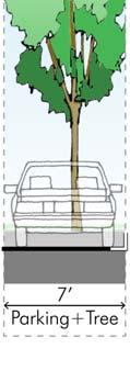
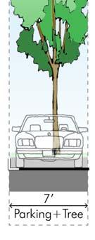
12 Question 3: Portola Drive Streetscape Improvements Lastly, each group was asked to discuss various mobility and safety improvement options along Portola Drive. They were asked to build their own ideal future street cross section, making sure they include enough features to fill the entire Portola Drive right of way. Question 3: How should the Portola Drive right ofway be best used to meet the needs of cars, trucks, buses, bicyclist and pedestrians? 12
13 Question 2: Portola Drive Streetscape Improvements Community Input Street Design Transition Portola Drive from its current four travel lane configuration to a two travel lane with a center turn lane configuration (e.g., four lanes to three) Consider Rumble Bumps to slow traffic Create better bicycle lanes Add pedestrian bulbouts and medians near intersections Reduced speed limits to improve safety Maintain vehicle traffic flow (e.g., do not make traffic worse) Incorporate nice, pedestrian scale lighting Bicycles Create painted/protected bicycle lanes that are removed from car traffic flow Consider establishing a bicycle share program Ensure bicycle facilities are the same level as the roadway Pedestrians Create more and safer street crossings with better lighting Consider raised crosswalks Remove pedestrian barriers and obstacles (ADA compliance) Ensure smooth and continuous sidewalks throughout the Project Area Consider signals at the 41 st Avenue and Portola Drive intersection to improve pedestrian safety 13
14 Question 2: Portola Drive Streetscape Improvements (continued) Community Input (continued) Parking Consider diagonal parking to increase the amount of on street parking Centrally locate pockets of parking along the corridor Consider opportunities for shared parking Consider the County purchasing and building new parking Driveways Identify a strategy to reduce driveway conflicts with pedestrians, bicyclists and motorists (e.g., ingress and egress from properties) Consider a proactive access management program Portola Drive and 41 st Street Intersection Evaluate the feasibility of a roundabout to improve traffic flow and reduce conflicts Green Streets Install catchment basins to capture/treat onsite water runoff Integrate Green Street features into the sidewalk Do not use pesticides of any kind Parks and Open Space Identify an opportunity for a central green space along Portola Drive Require new developments to include plaza spaces 14
15 B. Individual Group Responses 15
16 Group 1: Vision for the Pleasure Point Commercial Area The group confirmed the following Vision Elements and added new ones(s) in purple: Protect Local Character Improve Pedestrian (more sidewalks) Improve Bicycle Mobility (better bike lanes) Ensure Sustainability (bioswales) Create Parking Strategies (County should purchase sites) Ensure Economic Vitality Minimize Impacts to Local Businesses Improve/Maintain Sidewalks Create Better Signage 16
17 Group 1: Building and Site Character Considerations Group Input (not unanimous) Building Characteristics Minimize impacts to local businesses Have a meeting specifically with business owners Maintain the existing public landscaping Do not plant messy trees Ensure economic vitality! Expand the Study Area boundary Preference is not to have three stories, but it may allow better transit and more room for housing Setbacks and Stepbacks Consider variability in building setbacks Ensure third story stepbacks Art and Wayfinding Create image signs for residents and pamphlets Install better signage 17
18 Group 1: Portola Drive Streetscape Improvements Group Input (not unanimous) Street Design Reduce the number of drive lanes (four lanes creates freeway ) Make it easier to get into and out of buses Install a stoplight at 41 st Avenue Prohibit left turns Bicycles Install more bike parking Create continuous bike lanes Pedestrians Create more crosswalks Improve and maintain sidewalks Parking Consider underground/rooftop parking Increase required parking ratios to ensure there is adequate parking Have the County purchase land for new parking structures Green Streets Install bioswales and permeable paving on sidewalks 18

19 Group 1: Portola Drive Streetscape Improvements Group s Preferred Street Cross Section 19

 in purple: Protect Local Character")

 Improve")
20 Group 2: Vision for the Pleasure Point Commercial Area The group confirmed the following Vision Elements and added new ones(s) in purple: Protect Local Character Improve Pedestrian Safety Improve Bicycle Mobility Ensure Sustainability Create Parking Strategies Ensure Economic Vitality Bring the Community Together (north and south) Improve Safety Maintain Village Feel 20
21 Group 2: Building and Site Character Considerations Group Input Building Characteristics Maintain the Village Feel with a beachy variety of design Prohibit new chains or franchises, big box stores, gas stations, industry or warehouses Prohibit structures over two stories so there are no buildings looking down into the neighborhoods Bring the community together (north and south) Bring the Lower 41 st Avenue Vision and Concepts onto Portola Drive Create a Design Review Committee for Pleasure Point (local) Prohibit brightly lit signs at night Setbacks and Stepbacks Maintain a 10 foot setback with no variances Truck Access Prohibit delivery trucks on the avenues and within neighborhoods 21
22 Group 2: Building and Site Character Considerations Group Input Street Design Reduce the street to two travel lanes with a center left turn lane Bicycles Improve bicycle safety Ensure bicycle lanes are the same height as the roadway Locate bicycle lanes in between parking and the sidewalk Pedestrians Improve pedestrian safety Create wider sidewalks Add a new crosswalk at 37 th Avenue Add clearly lit crosswalks at 26 th, 30 th, 32 nd, 36 th, 37 th and 41 st Avenues Parking Restricted parking 20 feet back from any intersection on both the right and left hand sides Consider parking structures at either end of 41 st and 30 th Avenues Prohibit parking on the avenue side. No parking on south side. Consider off street parking either underground or behind the building Ensure safety when siting parking along Portola Drive (e.g., red curbs, sight distance) Green Streets Eliminate pesticides and have organic vegetables/fruit instead of flowers 22

23 Group 2: Portola Drive Streetscape Improvements Group s Preferred Street Cross Section 23
24 Group 3: Vision for the Pleasure Point Commercial Area The group confirmed the following Vision Elements and added new ones(s) in purple: Protect Local Character Improve Pedestrian Safety Improve Bicycle Mobility Ensure Sustainability Create Parking Strategies Ensure Economic Vitality Public Art 24
25 Group 3: Building and Site Character Considerations Group Input Building Characteristics Ensure good, high aesthetic architecture Require mixed material buildings Prohibit cookie cutter or boxes Consider a local Design Review Board Continue the character of 41 st Avenue Add more restaurants and residential if you allow two story developments Setbacks and Stepbacks Ensure there is adequate setbacks on all buildings Create outdoor seating in front of green spaces Have better availability to use garbage cans Art and Wayfinding Add more public art! Have the County build infrastructure to attract new businesses Get rid of junk yards Prohibit new auto or industrial businesses 25
26 Group 3: Portola Drive Streetscape Improvements Group Input Street Design Reduce the number of vehicle travel lanes from four to three (two travel lanes with a center left turn lane) Pedestrians Create wider sidewalks Parking Consider angled parking Have the County purchase property for new parking areas Have more parking behind buildings and within side setbacks Improve and expand landscaping Driveways Reduce driveways and have shared driveways 26
27 Group 3: Portola Drive Streetscape Improvements Group s Preferred Street Cross Section 27

 in purple: Protect Local Character")


28 Group 4: Vision for the Pleasure Point Commercial Area The group confirmed the following Vision Elements and added new ones(s) in purple: Protect Local Character Improve Pedestrian Safety Ensure Sustainability Create Parking Strategies Ensure Economic Vitality for Locals Promote Small/Locally Owned Businesses Slow Traffic Speed Emphasize Recreation and Residential Vibe 28
29 Group 4: Building and Site Character Considerations Group Input Building Characteristics Focus on small, locally owned businesses Encourage more local serving commercial areas Ensure two story maximum for all buildings Emphasize recreation and residential uses Implement strategies to control trash Evaluate the necessity of rezoning uses along Portola Drive Improve aesthetics along Portola Drive Consider vacation vs. residents occupying units Setbacks and Stepbacks Maintain setbacks between commercial and residential Require stepbacks for third stories Truck Access Mandate that trucks cannot use residential streets Establish designated loading zones for businesses Utilize the center turn lane for deliveries to keep trucks off residential streets Restrict delivery times Holding businesses accountable for deliveries Art and Wayfinding Create more street art 29
30 Group 4: Portola Drive Streetscape Improvements Group Input Street Design Slow vehicle traffic, possibly with more street slope Change the street to two travel lanes with a center turn lane Bicycles Create well defined bike lanes Pedestrians Parking Create public parking lot(s) Increase the amount of parking required for new developments Add street parking on Portola Drive Driveways Reduce the number of active driveways Increase buffers between vehicle traffic and pedestrians Enforce business driveways Parks and Open Space Create pedestrian islands, raised Improve the quality of landscaping crosswalks and flashing light pedestrian crossings Do not use a landscape palette (prefer Add a crosswalk at 37 th an eclectic look) Avenue Encourage outdoor eating spaces Create corner bulbouts 30
31 Group 5: Vision for the Pleasure Point Commercial Area The group confirmed the following Vision Elements and added new ones(s) in purple: Protect Local Character Improve Pedestrian Safety Improve Bicycle Mobility Ensure Sustainability Create Parking Strategies Ensure Economic Vitality Ensure a Non Homogenous Look and Feel 31
32 Group 5: Building and Site Character Considerations Group Input Building Characteristics Preserve local character Encourage a non homogenous look for future development Encourage two story building heights three stories are okay with proper stepbacks and considerations for neighboring residential areas Prohibit chain stores Prohibit low income or affordable housing Ensure the first floor has retail/businesses and the second floor residential Protect older small businesses Sunset wrecking yards Have more frequent trash can pick ups Setbacks and Stepbacks Stepback second/third floors Truck Access Identify specific delivery access areas for all businesses Establish and enforce explicit delivery times, and prohibit them during peak traffic times Prohibit deliveries in residential areas Consider deliveries from the center turn lane Divert deliveries to through streets and not through neighborhood Create loading zones and times for deliveries, wide sidewalks Art and Wayfinding Install Welcome to Pleasure Point artwork and signage 32
33 Group 5: Portola Drive Streetscape Improvements Group Input Street Design Create a roundabout at the intersection of 41 st Avenue and Portola Drive Bicycles Install green bicycle lanes Pedestrians Install flashing lights at crosswalks Install lighting that does not trespass in neighborhoods Add shade Parking Consider shuttling visitors from parking at the mall to the Portola Drive area Underground parking Ensure trees are incorporated into parking lots Green Streets Incorporate bioswales into landscaping Create a uniform landscaping design Parks and Open Space Extend landscaping and design to side streets and alleys Encourage outdoor seating 33


34 Group 5: Portola Drive Streetscape Improvements Group s Preferred Street Cross Section 34
35 Group 6: Vision for the Pleasure Point Commercial Area The group confirmed the following Vision Elements and added new ones(s) in purple: Protect Local Character Improve Pedestrian Safety Improve Bicycle Mobility Ensure Sustainability Create Parking Strategies Ensure Economic Vitality Support Local Businesses Study Traffic Impacts Create a Roundabout at Portola Drive and 41 st Street 35
36 Group 6: Building and Site Character Considerations Group Input Building Characteristics Create more places for visitors to stay Close stores selling alcohol by 10 or 11 pm (so they do not disturb housing) Encourage two stories or three stories if appropriate (three stories okay with housing) Encourage buildings facing Portola Drive with parking in the back Setbacks and Stepbacks Tier height Prohibit zero foot setbacks of rear yards adjacent to residential areas Stepback upper floors when adjacent to residential areas Truck Access Prohibit delivery trucks on the avenues Create designated delivery hours Establish rules for delivery locations and times of day/week 36
37 Group 6: Portola Drive Streetscape Improvements Group Input Street Design Change the street to have two travel lanes to slow down traffic and protect pedestrians Add rumble bumps Focus attention to fixing circulation around 30 th Avenue and Portola Drive (near the 7/11) very unsafe Bicycles Create a bike share program Expand bike lanes (rather than adding bioswales) Prohibit plastic bike barriers (need something more substantial) Pedestrians Add blinking pedestrian crosswalks Add motion activated lighting Add wider sidewalks with seating areas Parking Locate parking at central areas along the corridor Shuttle people into the area as part of an overall parking strategy Require two minute loading zone Consider shared parking (especially at the corner of 41 st Avenue and Portola Drive) Green Streets Do not install bioswales Add drought tolerant landscaping Continue the landscaping from 41 st Avenue to Portola Drive Parks and Open Space Create new assigned community spaces 37


38 Group 6: Portola Drive Streetscape Improvements Group s Preferred Street Cross Section 38
39 Group 7: Vision for the Pleasure Point Commercial Area The group confirmed the following Vision Elements and added new ones(s) in purple: Protect Local Character Improve Pedestrian Safety Improve Bicycle Mobility Ensure Sustainability Create Parking Strategies Ensure Economic Vitality Protect Residential Parking Preserve Mixed Use Area Preserve Existing Building Sizes and Two Story Height Highlight Public Art/Culture 39
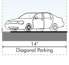
40 Group 7: Building and Site Character Considerations/Streetscape Group Input Building Characteristics Require all buildings to be no taller than two stories Consider projects like the Bella Notte Hotel Question: what is the radius of notification for new developments? Street Design Reduce the number of vehicle lanes on Portola Drive Reduce traffic speeds Consider a three lane trial project Bicycles Improve bike lane visibility Pedestrians Create straight, flat sidewalks for wheelchair access Install village lighting on Portola Drive Increase crosswalk visibility Parking Install diagonal parking Ensure adequate onsite parking (prefer parking behind buildings) Require two parking spaces per residence Consider remote shuttles from Capitola Green Streets Install permeable sidewalks Parks and Open Space Improve landscaping and tree maintenance 40
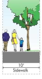
41 Group 7: Portola Drive Streetscape Improvements Group s Preferred Street Cross Section Sidewalk Bike Lane Bike Lane Sidewalk 41
42 Group 8: Vision for the Pleasure Point Commercial Area The group confirmed the following Vision Elements and added new ones(s) in purple: Create a Local Destination Corridor Improve Pedestrian and Bicycle Mobility Protect Local Character Ensure Sustainability Create a Parking Strategy Improve Traffic Flow Create Community Spaces Add Greenspace and Landscaping Ensure The Area is Resident Oriented 42
43 Group 8: Building and Site Character Considerations Group Input Building Characteristics Maintain a Village Feel Avoid high density housing (there is a lot of that already) Promote an eclectic style that is beachy with wood (as opposed to stucco) Protect local character (low rise) Encourage more businesses that a resident would need Encourage a European style community with centralized parking Prohibit new hotels Maintain two story maximum Minimize business redundancy Ensure the residents quality of life is the highest priority Setbacks and Stepbacks Have stepbacks on upper levels Consider balconies Truck Access Use alleys for delivery trucks to get them off Portola Drive 43
44 Group 8: Portola Drive Streetscape Improvements Group Input Street Design Reduce the number of vehicle lanes to three with a green median Improve traffic flow Improve connectivity to East Cliff Village and Upper 41 st Avenue Maintain Portola Drive as a key traffic artery Add public transportation options Bicycles Add shared green bike lanes Pedestrians Create wider sidewalks to make the area more walkable Improve pedestrian safety Minimize sound and light pollution Parking Create a parking strategy that all business must provide/contribute to a centralized parking area Minimize the number of parking lots, entries and exists onto Portola Drive Create parking structures (seismic issues with underground parking) Green Streets Ensure sustainability (bioswales, pervious surfaces, trash management) Parks and Open Space Create public spaces for community events Enhance greenspace and landscaping 44


45 Group 8: Portola Drive Streetscape Improvements Group s Preferred Street Cross Section 45
46 Next Steps 46


 Holding Community")
 Please visit the County s website")
47 Next Steps This project includes many opportunities for the community to review draft concepts, provide detailed feedback and ideas, and help refine potential changes to design guidelines and standards for the Pleasure Point Commercial Corridor. Major next steps include: Releasing a draft Pleasure Point Design Framework that will include initial design concepts and streetscape improvements (November 2017) Holding Community Workshop #2 to discuss and solicit community feedback on the draft concepts (November 2017) Please visit the County s website to stay current with all project related information and meetings: 47
Tonight is for you. Learn everything you can. Share all your ideas.
 Strathcona Neighbourhood Renewal Draft Concept Design Tonight is for you. Learn everything you can. Share all your ideas. What is Neighbourhood Renewal? Creating a design with you for your neighbourhood.
Vision: Traditional hamlet with an attractive business/pedestrian friendly main street connected to adjacent walkable neighborhoods
 N D. Focus Area II Vision: Traditional hamlet with an attractive business/pedestrian friendly main street connected to adjacent walkable neighborhoods Transit Road Focus Area II is located in the Hamlet
Table #6 VISION CHARACTERISTICS
 Table #6 VISION White Flint is a place to live, work, play, shop, and walk with sufficient density to encourage quality redevelopment. Vibrant streets and consistent streetscapes are important. CHARACTERISTICS
THE ALAMEDA CONCEPT DESIGN COMMUNITY MEETING 3. A Plan for The Beautiful Way JANUARY 28, 2010
 CONCEPT DESIGN COMMUNITY MEETING 3 JANUARY 28, 2010 AGENDA INTRODUCTION COMMUNITY INPUT ROADWAY STUDIES STREETSCAPE DESIGN STATIONS DISCUSSION SUMMARY AND DISCUSSION NEXT STEPS CLOSE INTRODUCTION SCHEDULE
Ocean Park Boulevard Green Street Project Alternatives & Trade Offs
 Planning Commission March 4, 2009 Ocean Park Boulevard Green Street Project Alternatives & Trade Offs Purpose of Tonight s Meeting Review concept plans and options Provide input on alternatives and trade-offs
PRINCE GEORGE S PLAZA METRO AREA PEDESTRIAN PLAN
 PRINCE GEORGE S PLAZA METRO AREA PEDESTRIAN PLAN May 28, 2008 Agenda Welcome and introductions Project overview and issue identification Planning context and strengths Design challenges and initial recommendations
Mission-Geneva Transportation Study Community Workshop 2 July 8, 2006
 Community Workshop 2 July 8, 2006 Small Group Workbook 1 Basic Improvements on Mission Street Streetscape. Pedestrian-scale lighting; landscaping; community art on utility boxes; more (possibly unique)
Ann Arbor Downtown Street Plan
 1 Ann Arbor Downtown Street Plan Public Workshop #1 We know that. 2 Public right-of-way (streets, sidewalks, and alleys) make up 30% of the total District area of downtown. Streets need to provide mobility
Comments The Plan for Port Whitby
 Comments The Plan for Port Whitby April 24th, 2013 Community Meeting #2 Summary Report Prepared by GLPi April 29th, 2013 1 Introduction The purpose of the Port Whitby Secondary Plan Update, Community Improvement
Agenda. Overview PRINCE GEORGE S PLAZA METRO AREA PEDESTRIAN PLAN
 PRINCE GEORGE S PLAZA METRO AREA PEDESTRIAN PLAN May 28, 2008 Agenda Welcome and introductions Project overview and issue identification Planning context and strengths Design challenges and initial recommendations
Chapter 3: Multi-Modal Circulation and Streetscapes
 CHAPTER 3: MULTI-MODAL CIRCULATION AND STREETSCAPES Chapter 3: Multi-Modal Circulation and Streetscapes Overview Streetscape improvements have already been completed for Depot Street between Main Avenue
Broad Street Bicycle Boulevard Design Guidelines
 Broad Street Bicycle Boulevard Design Guidelines Building from the strategies introduced in the 2013 Bicycle Transportation Plan and community input received thus far, City Transportation Staff have identified
7/23/2017 VIA . Michael Hanebutt City of Sacramento Community Development Department 300 Richards Boulevard, 3 rd Floor Sacramento, CA 95811
 7/23/2017 VIA EMAIL Michael Hanebutt City of Sacramento Community Development Department 300 Richards Boulevard, 3 rd Floor Sacramento, CA 95811 RE: 65 th Street Apartments (DR17-220) Dear Mr. Hanebutt:
Bicycle and Pedestrian Advisory Committee (BPAC) November 21, 2013
 November 21, 2013") Bicycle and Pedestrian Advisory Committee (BPAC) November 21, 2013 OVERALL LAND USE CONCEPT Overall Broadway Valdez District: 95.5 acres (35.1 acres right-of ways + 60.4 acres developable land) Plan Subareas:
Bicycle and Pedestrian Advisory Committee (BPAC) November 21, 2013 OVERALL LAND USE CONCEPT Overall Broadway Valdez District: 95.5 acres (35.1 acres right-of ways + 60.4 acres developable land) Plan Subareas:
WELCOME. Purpose of the Open House. Update you on the project. Present a draft recommended plan. Receive your input
 WELCOME Purpose of the Open House The Town of Smiths Falls has initiated the Beckwith Street Redevelopment Plan that includes the preparation of a streetscape functional design for the renewal of Beckwith
A CHANGING CITY. of Edmonton, it is essential that it reflects the long-term vision of the City.
 A CHANGING CITY By the year 2040, Edmonton will be home to more than 1 million people. To accommodate growth and support a healthy and compact city, we need a new approach to development/redevelopment
UPTOWN REGIONAL BIKE CORRIDORS PROJECT SAN DIEGO ASSOCIATION OF GOVERNMENTS
 UPTOWN REGIONAL BIKE CORRIDORS PROJECT SAN DIEGO ASSOCIATION OF GOVERNMENTS SUMMARY REPORT: COMMUNITY UPDATE MEETING February 6, 2014 6 8:30 p.m. Roosevelt Middle School Library 3366 Park Blvd, San Diego
Community Meeting February 27, 2007 Dorchester Avenue Transportation & Streetscape Improvements Action Plan February 27, 2007
 Community Meeting Tonight s Agenda 6:00 Introductions South Boston/Dot Ave Improvement Study Background 6:15 Consultant Introductions Review of Scope and Schedule Review of Proposed Corridor Wide Guidelines
FOCUS AREA 1 - Alberta Avenue Pocket Park 3 (121 Ave and 92 St)
") FOCUS AREA 1 - Alberta Avenue Pocket Park 3 (121 Ave and 92 St) New benches Plant evergreen trees Widen existing sidewalk from 1.5m to 1.8m Marked crosswalk 1.8m wide sidewalk Add pedestrian oriented lights
FOCUS AREA 1 - Alberta Avenue Pocket Park 3 (121 Ave and 92 St) New benches Plant evergreen trees Widen existing sidewalk from 1.5m to 1.8m Marked crosswalk 1.8m wide sidewalk Add pedestrian oriented lights
EXECUTIVE SUMMARY. Vision
 Vision Walking and bicycling in Salt Lake City will be safe, convenient, comfortable, and viable transportation options that connect people to places, foster recreational and economic development opportunities,
ALBERTA AVENUE WHAT WE HEARD REPORT BUILDING GREAT NEIGHBOURHOODS
 ALBERTA AVENUE WHAT WE HEARD REPORT BUILDING GREAT NEIGHBOURHOODS FEBRUARY 2019 EXECUTIVE SUMMARY Starting in 2019, Alberta Avenue will see the replacement and enhancement of its aging collector and local
COWETA HIGH SCHOOL AND EAST HIGHWAY 51
 COWETA HIGH SCHOOL AND EAST HIGHWAY 51 Lack of sidewalks along Ben Lumpkin Rd. Lack of crosswalks and ramps at intersection. Hwy 51 is wide to cross as a pedestrian. No ADA compliance or connection to
12/4/2016 VIA . RE: Grocery Outlet Del Paso (DR16-328)
") 12/4/2016 VIA EMAIL Ethan Meltzer, Assistant Planner City of Sacramento Community Development Department 300 Richards Blvd, 3 rd Floor Sacramento, CA 95811 RE: Grocery Outlet Del Paso (DR16-328) Dear Mr.
12/4/2016 VIA EMAIL Ethan Meltzer, Assistant Planner City of Sacramento Community Development Department 300 Richards Blvd, 3 rd Floor Sacramento, CA 95811 RE: Grocery Outlet Del Paso (DR16-328) Dear Mr.
STONY PLAIN ROAD STREETSCAPE
 Jasper Place Revitalization Strategy: Vision The people involved in the Jasper Place Revitalization Strategy envision: Goal 1: Feeling safe in our community Create a community where feeling safe is common--where
Living Streets Policy
 Living Streets Policy Introduction Living streets balance the needs of motorists, bicyclists, pedestrians and transit riders in ways that promote safety and convenience, enhance community identity, create
Ocean Park Boulevard Streetscape Improvement Project Alternatives & Trade Offs
 City Council Study Session January 27, 2009 Ocean Park Boulevard Streetscape Improvement Project Alternatives & Trade Offs Scope of Work Purpose of Tonight s Meeting Review work to date and direct staff
City of Novi Non-Motorized Master Plan 2011 Executive Summary
 City of Novi Non-Motorized Master Plan 2011 Executive Summary Prepared by: February 28, 2011 Why Plan? Encouraging healthy, active lifestyles through pathway and sidewalk connectivity has been a focus
Public Workshop #2. September 14, 2016
 Public Workshop #2 September 14, 2016 Agenda Welcome Project Overview Where We Have Been Alternatives for State Street Land Use Street Design Next Steps 2 Project Overview Create a Vibrant State Street
Victoria Park Master Plan
 Victoria Park Master Plan Phase I Presented By: ARCHITECTURAL ALLIANCE & HUGHES HUGHES INC. History of Victoria Park Phase I Purpose Inventory of Existing Conditions Identification of Options by Type (for
APPENDIX A: Complete Streets Checklist DRAFT NOVEMBER 2016
 APPENDIX A: Complete Streets Checklist DRAFT NOVEMBER 2016 Complete Streets Checklist MetroPlan Orlando s Complete Streets Checklist is an internal planning tool for staff to further implementation of
CONNECTIVITY PLAN. Adopted December 5, 2017 City of Virginia Beach
 CONNECTIVITY PLAN Adopted December 5, 2017 City of Virginia Beach CONTENTS 1.0 Background & Purpose... 2 2.0 Existing Inventory & Analysis... 3 ViBe District Existing Walking Conditions... 4 3.0 ViBe District
CURBSIDE ACTIVITY DESIGN
 5 CURBSIDE ACTIVITY DESIGN This chapter provides design guidance for separated bike lanes adjacent to curbside activities including parking, loading and bus stops. Typical configurations are presented
Item to be Addressed Checklist Consideration YES NO N/A Required Description Complete Streets Guidelines
 Passaic County Complete Streets Checklist - Concept Development Project Name Item to be Addressed Checklist Consideration YES NO N/A Required Description Complete Streets Guidelines Existing Plans Have
Executive Summary Route 30 Corridor Master Plan
 Route Corridor Master Plan Project Overview The Route Corridor Master Plan is a coordinated multimodal transportation and land use plan for the entire stretch of Route through East Whiteland Township,
Chapter 2: Standards for Access, Non-Motorized, and Transit
 Standards for Access, Non-Motorized, and Transit Chapter 2: Standards for Access, Non-Motorized, and Transit The Washtenaw County Access Management Plan was developed based on the analysis of existing
STEERING COMMITTEE MEETING June 17, Streetscape Overview Burlington Comprehensive Master Plan
 STEERING COMMITTEE MEETING June 17, 2015 Streetscape Overview Burlington Comprehensive Master Plan 1 Introduction Slide This slide show was presented to the Burlington Steering Committee on June 17, 2015
FONTAINE AVENUE STUDY Final Report
 FONTAINE AVENUE STUDY Final Report March 28, 2005 FONTAINE AVENUE STUDY City of Charlottesville March 28, 2005 Renaissance Planning Group Kenneth Schwartz, FAIA, AICP Director of Design Leigh Wilkerson,
5/7/2013 VIA . RE: University Village Safeway Expansion (P13-019)
") 5/7/2013 VIA EMAIL David Hung, Associate Planner Community Development Department, Current Planning Division City of Sacramento 300 Richards Boulevard, 3 rd Floor Sacramento, CA 95811 RE: University Village
5/7/2013 VIA EMAIL David Hung, Associate Planner Community Development Department, Current Planning Division City of Sacramento 300 Richards Boulevard, 3 rd Floor Sacramento, CA 95811 RE: University Village
Montford Drive Parking & Circulation Study
 Montford Drive Parking & Circulation Study Parking & Circulation Study Follow up to the Area Plan based on what we heard Purpose 1 2 3 4 To look closer and evaluate parking and network related issues (including
95 th Street Corridor Transportation Plan. Steering Committee Meeting #2
 95 th Street Corridor Transportation Plan Steering Committee Meeting #2 February 18, 2015 PURPOSE OF THE MEETING Update Steering Committee Present Community/Stakeholder Survey Results Present Transportation
PEDESTRIAN ACTION PLAN
 ATTACHMENT 2 CITY OF SANTA MONICA PEDESTRIAN ACTION PLAN CITY OF SANTA MONICA PEDESTRIAN ACTION PLAN This page intentionally left blank EXECUTIVE SUMMARY CHAPTER 1 EXECUTIVE SUMMARY Setting the Stage
o n - m o t o r i z e d transportation is an overlooked element that can greatly enhance the overall quality of life for the community s residents.
 N o n - m o t o r i z e d transportation is an overlooked element that can greatly enhance the overall quality of life for the community s residents. 84 Transportation CHAPTER 11 INTRODUCTION Transportation
5/31/2016 VIA . Arwen Wacht City of Sacramento Community Development Department 300 Richards Blvd., 3 rd Floor Sacramento, CA 95811
 5/31/2016 VIA EMAIL Arwen Wacht City of Sacramento Community Development Department 300 Richards Blvd., 3 rd Floor Sacramento, CA 95811 RE: El Pollo Loco (P16-028) Dear Ms. Wacht: WALKSacramento has reviewed
REGIONAL BICYCLE AND PEDESTRIAN DESIGN GUIDELINES
 REGIONAL BICYCLE AND PEDESTRIAN DESIGN GUIDELINES November 16, 2011 Deb Humphreys North Central Texas Council of Governments Bicycle and Pedestrian Advisory Committee Snapshot of the Guide 1. Introduction
City of Elizabeth City Neighborhood Traffic Calming Policy and Guidelines
 City of Elizabeth City Neighborhood Traffic Calming Policy and Guidelines I. Purpose: The City of Elizabeth City is committed to ensure the overall safety and livability of residential neighborhoods. One
TOWN OF WILLIAMSTON, SC BICYCLE AND PEDESTRIAN MASTER PLAN TOWN OF WILLIAMSTON, SC BICYCLE AND PEDESTRIAN MASTER PLAN
 TOWN OF WILLIAMSTON, SC BICYCLE AND PEDESTRIAN MASTER PLAN Americans Want Choices 55% of Americans would rather drive less & walk more. Transit use is growing faster than population or highway travel.
Complete Streets. Designing Streets for Everyone. Sarnia
 Complete Streets Designing Streets for Everyone Sarnia Complete Streets ~ Sarnia ~ 2018 Introduction Our City is made up of a network of streets that we use to go for a walk, cycle to work, drive to the
Complete Streets: Planning, Policy & Performance
 Complete Streets: Planning, Policy & Performance Tell Us About Your CS Experiences Successes Hardships Funding Politics Safety Not every street needs to be complete, but every mode needs a complete network.
Mainstreet Master Plan Land Use
 Mainstreet Master Plan 04 Land Use Top Recommendations Active Uses: Promote active ground-floor uses such as retail, restaurants, galleries and personal services with interactive storefronts for Mainstreet
The Leadville Bikeway Design Recommendations DRAFT January 2018
 The Leadville Bikeway Design Recommendations DRAFT January 2018 Overview The Leadville Bikeway project aims to create a bikeway that is compatible with and adds value to the neighborhood and surrounding
MARTIN LUTHER KING JR. WAY
 OCTOBER 2011 40 Vision and Goals The Martin Luther King, Jr. Way Illustrative Master Plan that follows has been developed through a process of community involvement. It expresses a long term vision for
Make Lincoln Highway an economically vibrant corridor that is safe, efficient, and beautiful for local residents and visitors.
 Lincoln Highway Streetscape Plan Stakeholder Workshop #2 Handout Contents Introduction and Project Vision Planning Principles Specific Recommendations including a Proposed Typical Roadway Section Renderings
Bicycle and Pedestrian Chapter TPP Update Overview. TAB September 20, 2017
 Bicycle and Pedestrian Chapter TPP Update Overview TAB September 20, 2017 Bicycling & Walking in the Twin Cities Where are we now? The Bike-Pedestrian system Current trends New developments Where are we
Proposed. City of Grand Junction Complete Streets Policy. Exhibit 10
 Proposed City of Grand Junction Complete Streets Policy Exhibit 10 1 City of Grand Junction Complete Streets Policy Vision: The Complete Streets Vision is to develop a safe, efficient, and reliable travel
S T A T I O N A R E A P L A N
 The Circulation and Access Plan describes vehicle, pedestrian, and transit improvements recommended within the Concept Plan. In order to create and sustain a vibrant business district that provides pedestrian-friendly
Caltrans Sloat Boulevard Pedestrian Safety Project Response to Community Questions, Comments & Concerns
 Caltrans Sloat Boulevard Pedestrian Safety Project Response to Community Questions, Comments & Concerns Revised: May 10, 2016 The California Department of Transportation (Caltrans) is planning various
11/28/2016 VIA
 11/28/2016 VIA EMAIL Ethan Meltzer, Assistant Planner City of Sacramento Community Development Department 300 Richards Blvd., 3 rd Floor Sacramento, Ca 95811 RE: Natomas Corporate Center Commercial Building
CRESTON ROAD COMPLETE AND SUSTAINABLE STREETS CORRIDOR PLAN
 CRESTON ROAD COMPLETE AND SUSTAINABLE STREETS CORRIDOR PLAN Preferred Plan Community Presentation September 27, 2017 City of El Paso de Robles in partnership with: Local Government Commission, W-Trans,
Active Transportation Rail to River Corridor. Community Meeting - Segment A
 Active Transportation Rail to River Corridor Community Meeting - Segment A June 29, 2017 Tonight s Agenda > Open House (30 min) > Welcome / Project Overview > Presentation of 30% Design Refinements > Next
5 CIRCULATION AND STREET DESIGN
 5 CIRCULATION AND STREET DESIGN This chapter describes circulation and streetscape improvements proposed for the Northwest Chico Specific Plan Area. It includes detailed design specifications for existing
Monterey Road Complete Streets
 Monterey Road Complete Streets Complete Street Objectives Improve livability and economic vitality Enhance pedestrian environment Accommodate bicyclists safely Reduce noise and air pollution Create attractive,
TRAVEL PLAN: CENTRAL EUROPEAN UNIVERSITY CAMPUS REDEVELOPMENT PROJECT TRAVEL PLAN. Central European University Campus Redevelopment Project.
 TRAVEL PLAN Central European University Campus Redevelopment Project Page 1 Table of Contents Introduction... 3 Background... 7 Building Users... 7 Transportation in Community Consultation... 7 Summary
BROOKLAND Multi-Modal Transportation & Streetscape Study* NE Washington, DC
 BROOKLAND Multi-Modal Transportation & Streetscape Study* NE Washington, DC The study s goal is to create a multi-modal transportation and streetscape design plan to increase transportation efficiency,
David Hung, Associate Planner City of Sacramento Community Development Department 300 Richards Boulevard, 3 rd Floor Sacramento, CA
 June 13, 2016 VIA EMAIL David Hung, Associate Planner City of Sacramento Community Development Department 300 Richards Boulevard, 3 rd Floor Sacramento, CA 959811 RE: Fire Station 14 (DR16-128) Dear Mr.
complete streets design and construction standards public primer City of Edmonton
 complete streets design and construction standards public primer City of Edmonton introduction Complete Streets are streets for everyone: people who walk, wheel, bike, take transit, or drive. They are
122 Avenue: 107 Street to Fort Road
 : 107 Street to Fort Road November 24, 2015 4:30 8:00 p.m. Meeting Purpose Summarize project work completed to date Share results of public input from Phase 1 Share the draft concept plan and proposed
Chapter 4 TOOLBOX AND SAMPLE BIKE BOULEVARD LAYOUT
 Chapter 4 TOOLBOX AND SAMPLE BIKE BOULEVARD LAYOUT OVERVIEW This chapter describes a cohesive set of strategies to create a bicycle boulevard, namely to make streets safer and more efficient for bicycle
Report. Typical Sections. City of Middleton, WI
 Report Typical Sections City of Middleton, WI December 2006 Report for City of Middleton, Wisconsin Typical Sections repared by: Traffic Associates LLC and STRAND ASSOCIATES, INC. 910 West Wingra Drive
COMMUNITY WORKSHOP #2 DOWNTOWN CONCORD SPECIFIC PLAN
 COMMUNITY WORKSHOP #2 Timeline 21-month process Tasks 1-3; Basis for the preparation of the plan (Jan. through March) Tasks 4-5; Development and Evaluation of Alternatives. Selection of Preferred Alternative.
Exhibit 1 PLANNING COMMISSION AGENDA ITEM
 Exhibit 1 PLANNING COMMISSION AGENDA ITEM Project Name: Grand Junction Circulation Plan Grand Junction Complete Streets Policy Applicant: City of Grand Junction Representative: David Thornton Address:
8/1/2018 VIA . Darcy Goulart City of Rancho Cordova Planning Department 2729 Prospect Park Drive Rancho Cordova, CA 95670
 8/1/2018 VIA EMAIL Darcy Goulart City of Rancho Cordova Planning Department 2729 Prospect Park Drive Rancho Cordova, CA 95670 RE: Towne Place Suites by Marriott Hotel (DD9806) Dear Ms. Goulart: WALKSacramento
CONNECTING PEOPLE TO PLACES
 CONNECTING PEOPLE TO PLACES 82 EAST BENCH MASTER PLAN 07 Introduction The East Bench transportation system is a collection of slow moving, treelined residential streets and major arteries that are the
WHEREAS delivery trucks also pass through the Narrows, into the northern parking lot, to loading docks in the back of the building.
 CEDAR-ISLES-DEAN NEIGHBORHOOD ASSOCIATION ( CIDNA ) RESOLUTION OPPOSING A DRUG STORE DRIVE THRU, AND COMMENDING DORAN COMPANIES FOR PROPOSING MITIGATING AMENITIES INCLUDING NEW LANDSCAPING AND A DEDICATED
What Is a Complete Street?
 Session 5 Charleen Zimmer, AICP, Zan Associates May 5-7, 2010 What Is a Complete Street? May 2010 5-1 Not a Complete Street More of a Complete Street May 2010 5-2 Benefits of Complete Streets Safety for
Omaha s Complete Streets Policy
 Omaha s Complete Streets Policy (Adopted August 2015) VISION To create great places and enhance our quality of life, the City of Omaha will provide safe, accessible streets for all users. Complete Streets
Memo. Ocean Avenue Corridor Design Project Public Workshop #2 Summary
 Ocean Avenue Corridor Design Project Public Workshop #2 Summary The second public workshop for the Ocean Avenue Corridor Design Project was held on Wednesday, May 14, 2014 from, 6 to 8 pm at Lick Wilmerding
PEDESTRIAN CIRCULATION & STREETSCAPE DESIGN
 CHAPTER 4 Chapter 4 Pedestrian Circulation & Trails PEDESTRIAN CIRCULATION & STREETSCAPE DESIGN In recent years, the City has constructed new sidewalks and enhanced existing ones in the downtown with brick
Paoli Road Improvement Feasibility Study
 Paoli Road Improvement Feasibility Study & Public Participation Project March 24, 2015 Prepared for: Tredyffrin Township Prepared by: McMahon Associates, Inc. with Town Planning Partnership, LLC Glackin
Steps to Conducting a Complete Streets Assessment
 Steps to Conducting a Complete Streets Assessment Familiarize yourself with Complete Streets Read through the Complete Streets Assessment Guidelines. This will give you an idea of what Complete Streets
Display Boards Including Five Refined Design Concepts
 APPENDIX D Workshop Session 3 Sign-in sheets Agenda Booklet Display Boards Including Five Refined Design Concepts PowerPoint Presentation Questions Recorded Discussion of Preference Exercise AGENDA
Anholm Bikeway Plan Planning Commission Meeting Summary (8/14/18)
") Anholm Bikeway Plan Planning Commission Meeting Summary (8/14/18) Overview: On August 14, 2018, the Planning Commission considered plans for the middle section of the Anholm Bikeway Plan, focusing on the
Anholm Bikeway Plan Planning Commission Meeting Summary (8/14/18) Overview: On August 14, 2018, the Planning Commission considered plans for the middle section of the Anholm Bikeway Plan, focusing on the
Lincoln Highway Streetscape Plan Concept Plan
 Lincoln Highway Streetscape Plan Concept Plan November 14, 2014 Introduction This report provides a summary of conceptual transportation, land use, and design recommendations in the Lincoln Highway Streetscape
MAG Town of Cave Creek Bike Study Task 6 Executive Summary and Regional Significance Report
 Page 1 MAG Town of Cave Creek Bike Study Task 6 Executive Summary and Regional Significance Report August 1, 2012 MAG Project #481 Page 2 Task 6 Executive Summary and Regional Significance Report Introduction
City of Davis East Covell Corridor Plan
 Community Open House #2 January 22, 2014 6:00 8:00 p.m. Veterans Memorial Center, Club Room City of Davis Introduction The (ECCP) is a taking a comprehensive look at the existing transportation systems
WELCOME Mission-Geneva Transportation Study
 WELCOME Mission-Geneva Transportation Study Study Process and Schedule 2005 2006 Oct Nov Dec Jan Feb Mar Apr May Jun Jul Aug Sept Oct Task 2 Develop Outreach Plan Task 3 Document Existing Conditions/ Prioritize
The Wiggle Route in Context
 The Wiggle Route in Context In a city of hills, the Wiggle is an important route because it winds its way along the flattest streets from Market to the Panhandle, bringing residents to local parks and
Design Guidelines. Overview. Design Vision for Yellow Brick Road
 Design Guidelines Overview This section presents the design vision for the Yellow Brick Road network. The Yellow Brick Road is envisioned to be an interconnected network of safe and secure roadways where
PROJECT OVERVIEW. 20th Avenue Project Limits (Lincoln Way to Wawona St)
") PROJECT OVERVIEW In 2014, San Francisco adopted Vision Zero as City policy, with a commitment to eliminate all traffic deaths in the City by 2024. nue Project Limits (Lincoln Way to St) Collision data
PROJECT OVERVIEW In 2014, San Francisco adopted Vision Zero as City policy, with a commitment to eliminate all traffic deaths in the City by 2024. nue Project Limits (Lincoln Way to St) Collision data
6/14/2013 VIA . Evan Compton, Associate Planner Community Development Department City of Sacramento 300 Richards Blvd Sacramento, CA 95814
 6/14/2013 VIA EMAIL Evan Compton, Associate Planner Community Development Department City of Sacramento 300 Richards Blvd RE: Sacramento Natural Foods Co-Op (P13-025) Dear Mr. Compton: WALKSacramento appreciates
Appendix 3 Roadway and Bike/Ped Design Standards
 Appendix 3 Roadway and Bike/Ped Design Standards OTO Transportation Plan 2040 4/20/2017 Page A3-1 Adopted Standards The adopted OTO Design Standards and Major Thoroughfare Plan are contained herein.
Miami Health District
 Miami Health District Streetscapes, Gateways, and Signage Basis of Design Report Study Miami Partnership Meeting July 21, 2008 Gannett Fleming EDAW The Corradino Group Sponsored by the Miami Partnership:
MEDIAN DESIGN example median A
 MEDIAN DESIGN example median A MLK Blvd Design Workshop #3 September 21, 2010 Participants voted on each idea, gave comments about specific ideas or general comments about all ideas. Comments and suggestions
6/22/2018 VIA . Darcy Goulart, Planning Manager City of Rancho Cordova Planning Department 2729 Prospect Park Drive Rancho Cordova, CA 95670
 6/22/2018 VIA EMAIL Darcy Goulart, Planning Manager City of Rancho Cordova Planning Department 2729 Prospect Park Drive Rancho Cordova, CA 95670 RE: Quick Quack Car Wash (DD9801) Dear Ms. Goulart: WALKSacramento
Plant City Walk-Bike Plan
 Plant City Walk-Bike Plan Plant City Commute Mode Share 2.2% 1.4% 2.9% Drove alone 10.2% Carpooled Public transportation (0.1%) Walked Used a Bike (0.4%) 82.9% Taxicab, motorcycle, or other means Worked
STREETSCAPE CONCEPTS
 STREETSCAPE S CARGO WAY CARGO WAY CYCLE TRACK Streetscape Concepts JENNINGS ST Illustrative Plan EVANS AVE PG&E BAY TRAIL HERON S HEAD PARK The recommended improvements build off the planned improvements
50 Avenue S.W. Corridor Study Glenmore Aquatic Centre Drop-In Event
 Project overview The City of Calgary is conducting a transportation corridor study of 5 Avenue S.W., between Crowchild Trail and 4A Street S.W. In 29, it was reclassified as a Parkway under the Calgary
11/3/2014 VIA . WALKSacramento has reviewed the Stockton and T Mixed-Use project at 3675 T Street in the
 11/3/2014 VIA EMAIL Antonio Ablog Planning Department City of Sacramento 300 Richards Boulevard Sacramento, CA 95811 RE: Design Review for Stockton and T Mixed-Use (P14-042) Dear Mr. Ablog: WALKSacramento
Polk Streetscape Project
 What is this project? The Polk Streetscape Project is an effort to improve safety for everyone traveling on Polk Street between Union and McAllister streets. Also included in this project are paving, sewer
Downtown Naples Mobility and Connectivity Study. Naples City Council Presentation January 2017
 Downtown Naples Mobility and Connectivity Study Naples City Council Presentation January 2017 Agenda 1. Introduction 2. Scope Review 3. Project Schedule 4. Existing Conditions 5. Public Charrette 6. Mobility
About the study. North Milwaukee Ave. Key goals of this study are to: Achieve Vision Zero* by. Harmonize the space and improve walkability
 About the study Key goals of this study are to: North Milwaukee Avenue is a local and regional street for multiple modes of transportation. It is officially zoned and functions as a pedestrian street southeast