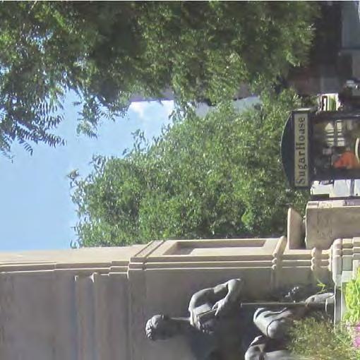
DRAFT CIRCULATION AND STREETSCAPE AMENITIES. Plan for the Sugar House Business District AUGUST 2012
|
|
|
- Horatio Fletcher
- 5 years ago
- Views:
Transcription


1 CIRCULATION AND STREETSCAPE AMENITIES Plan for the Sugar House Business District Prepared for: Prepared by: AUGUST South 1300 East, Suite 220 Salt Lake City, UT P (801)
 document was completed by Fehr & Peers under the direction of")
.")


 draw crowds from many areas of the Salt Lake region.")


2 - Sugar House Business District Circulation Plan The Circulation Plan for the Sugar House Business District (the Plan) document was completed by Fehr & Peers under the direction of Salt Lake City s Redevelopment Agency (RDA) and the Community and Economic Development Department (Transportation Division). A stakeholder committee comprised of staff from a range of departments, as well as property owners, business owners, and representatives from local institutions, provided guidance throughout the process. Sugar House is a unique community that attracts a broad range of local and national retailers. Its festivals and markets (i.e. farmer s market, arts festival, Fourth of July fireworks, etc.) draw crowds from many areas of the Salt Lake region. The residential neighborhoods in and around the Sugar House Central Business District (CBD) provide for those seeking a rich urban lifestyle as well as those seeking a house and a yard on a quiet, leafy street. As a result of this success, several of Sugar House s CBD streets are approaching their effective motor vehicle capacity during the peak hours of the day, and there are few opportunities or desire to expand capacity to accommodate more cars. For the Sugar House CBD to continue to thrive, it must make more efficient use of its existing transportation infrastructure. This means making better use of transit, managing parking supply more carefully, and increasing the walkability and bikability of CBD streets so that intra-cbd trips will primarily be served by walking, biking, and transit rather than driving. This report is structured around these principles,, and its chapters are arranged accordingly: CHAPTER 1: INTRODUCTION Chapter 2: Study Area Description, provides multi-modal existing conditions information and data within the study boundaries off the plan. Chapter 3: Vision and Goals, identifies the community and stakeholders desires and goals. Chapter 4: Project Evaluation, examines the feasibility of specific transportation related projects in the study area. Chapter 5: Implementation Plan, includes a summary of the key projects, actions, and strategies. Chapter 6: Next Steps, identifies the next steps to achieve the circulationn goals. Chapter 7: Streetscape Amenities Plan, identifies street amenities too enhance the visual characteristics of the corridors. July INTRODUCTION 1
 to the south, and Ramona Avenue to north (see Figure 2-1).")
.")


3 - Sugar House Business District Circulation Plan 2.1 The Plan Study Area is within the area bounded by 1300 East to the east, 900 East to the west, Interstate- the 80 (I-80) to the south, and Ramona Avenue to north (see Figure 2-1). Land Use CHAPTER 2: STUDY AREA DESCRIPTION The Sugar House neighborhood is located in eastcentrall Salt Lake City, Utah, along the Wasatch Front (the western slope of the Wasatch Mountain Range) (see Figure 2.1-1). Sugar House, one of the original streetcar communities of Salt Lake City and one of the oldest neighborhoods, includes a broad mix of land uses, including commercial, office, and residential. The portion of the corridor between 900 East and 1300 East is one of the few areas along the Wasatch Front with the mix and density of land uses that couldd facilitate active transportation (pedestrian and bicycle) investment. The area has a higher-than-average residential density and is within a convenient walk distance of many businesses.. In addition, there are a number of potential redevelopment sitess in the Study Area that could result in mixed-use development in areas surrounded by existing residential uses. The north part of the Study Area is predominately single-family residential with clusters of neighborhood commercial and a few mixed residential/business corridors, such as 1100 East and 2100 South. Several parks and institutional uses are dispersed throughout the outer boundaries of the Study Area. The close proximity of many mixed uses promotes walking as a mode of transportation. In addition to the general land uses described above, the following major activity centers are located within the Study Area: Sprague Library (Highland Drive) Sugar House Shopping Center (Highland Drive) Sugar House Shopping Commons (Highland Drive and 2100 South) July STUDY AREA DESCRIPTION 2

4 CIRCULATION STUDY AREA - NEIGHBORHOOD Figure 2-1 Sugar House Business District Circulation Plan N NOT TO SCALE Ramona Hollywood 2100 South Elm SUGAR HOUSE Wilmington PARK Sugarmont Simpson FAIRMONT PARK I-80 LEGEND 900 East Circulation Study Area 1100 East Highland 1200 East 1300 East


5 CIRCULATION STUDY AREA - REGIONAL Figure Sugar House Business Plan Circulation Plan N NOT TO SCALE South Temple DOWNTOWN UNIVERSITY OF UTAH PIONEER PARK 400 South 900 South 9th & 9th LIBERTY PARK 1300 South 1700 South 2100 South SUGAR SOUTH HOUSE SALT LAKE PARK I-80 FAIRMONT PARK LEGEND ROSE PARK Circulation Study Area I-15 State Street 700 East 1100 East Highland 1300 East Foothill


 Sugar House Park (1300 East and")
 Highland High School (2100 South) Westminster")
.")

 of commercial/office over the next several years.")
.")


6 - Sugar House Business District Circulation Plan Within one mile of the Study Area the following attractors also exist: The Study Area and existing major activity centers are shown in Figure In addition, four additional importantt activity centers are expected to soon be added to the Study Area: Fairmont Park and Aquatic Center (Sugarmont Park) Sugar House Park (1300 East and 2100 South) Forest Dale Golf Course (900 East) Intermountain Health Center (900 East) Highland High School (2100 South) Westminster College (1300 East) The Granite Block (on the south side of 2100 South at 1100 East). The Granite Block in downtown Sugar House is planned for redevelopment with a mixx of residential, commercial, and office use. Development plans include 200 new residencess and 200,000 square feet (SF) of commercial/office over the next several years. Westminster Student Housing (on the west side of 1300 East between Wilmington Avenue and 2100 South). The Westminster Student Housing project has begun construction on a mixed-use development with 16,0000 SF of academic space; 14,000 SF of retail space; and 54,000 SF of housing. Wilmington Gardens (Wilmington Avenue between Highland Drive and 1300 East). Wilmington Gardens in Sugar House is planned to be redeveloped with a mix of residential, community space, commercial, and office use. Development plans include 100,000 SF of residential with 20% affordable units; approximately 84,000 SF of commercial/office; and 45,000 SF of community space. Plans for Wilmington Gardens incorporate academic space for Westminster College. July STUDY AREA DESCRIPTION 5

7 MAJOR ACTIVITY CENTERS Figure Sugar House Business District Circulation Plan WESTMINSTER N NOT TO SCALE COLLEGE Ramona Hollywood URBANA ON 11TH SUGAR HOUSE APARTMENTS MONUMENT PLAZA 2100 South WESTMINSTER STUDENT HOUSING GRANITE BLOCK SPRAGUE PARLEY S TRAIL REDEVELOPMENT LIBRARY DRAW SUGAR HOUSE WILMINGTON COMMONS GARDENS Elm SUGAR HOUSE Wilmington PARK SUGAR HOUSE Sugarmont CENTER FAIRMONT AQUATIC CENTER Simpson FAIRMONT PARK I-80 LEGEND 900 East Circulation Study Area Major Activity Centers 1100 East Highland 1200 East 1300 East
.")

.")


8 - Sugar House Business District Circulation Plan 2.2 Sugar House Center (south of Wilmington Avenue between Highland Drive and 1300 East). The Sugar House Center is planned to be a mixed-use redevelopment project separated into multiple phases. Full build-out plans include 800 residential units, 380,000 SF of commercial/office use. A structured parking garage is also planned for this development site. The Parley s Trail Draw (1300 East on the south side of Westminster Student House). The Parley s Trail Draw project is a tunnel under 1300 East connecting Sugar House Park to Hidden Hollow, an integral part of the Parley ss Trail. Development Plans Planning for the Sugar House Streetcar Phase 1 Project has generated interest in the development community. The following developments within the Study Area have recently been constructed, are underway, or are approved, and are shown in Figure Urbana on Eleventh 29 condominium ms and 750 SF of ground floor retail. This project is 100 percent constructed. John Gardiner Apartment Complex 70 apartmentt units. This project is currently under construction and will be complete by Westminster Mixed-Use Project 44 three- and four-bedroounits with a total of 164 apartment beds, approximately 15,000 SF of office space, and 8,500 SF of retail space. Residential development associated with this project is part of the Westminster College expansion, and will serve as student housing. This is project is currently under construction project and will be complete by fall Wilmington Gardens Project between 212 residential units, including 5 townhomes; approximately 30,000 SF of office; and 60,000 SF of retail development. This project will be complete by Olsen Development residential and retail space is planned to front Wilmington Avenue on the Olsen property, which is located directly across the streett from Wilmington Gardens. This project is in partnership with Wilmingtonn Gardens, and the July STUDY AREA DESCRIPTION 7

9 900 East Ramona Hollywood 2100 South Elm FAIRMONT PARK PROPOSED DEVELOPMENT LOCATIONS Figure Sugar House Business District Circulation Plan 1100 East GRANITE BLOCK REDEVELOPMENT McClelland Sugarmont DESERT INDUSTRIES REDEVELOPMENT Simpson I East SUGAR HOUSE APARTMENTS WILMINGTON GARDENS Wilmington SUGAR HOUSE CENTER REDEVELOPMENT Highland 1300 East WESTMINSTER STUDENT HOUSING 12TH & VIEW N NOT TO SCALE SUGAR HOUSE PARK LEGEND Circulation Study Area Proposed Development Centers


, and only a few bicycle lanes.")

. Two regional trails are planned in the Study Area.")

10 - Sugar House Business District Circulation Plan developers are working together to implement a new vision for Sugar House over several acres. At the corner of Highland and Wilmington Avenues, the group is planning retail, office, and residential development. The group estimates that by 2015, an additional 100 residential units and 60,000 square feet of retail will be completed. Granite Block Development 210 residential units and 56,000 SF retail space by 2015, with the addition of 50,000 SF of office space by Boulder Venture Project 20,000 SF of retail and 30,000 SF of office. This project is currently under construction and will bee complete is the spring of Cowboy Partners Project 170 residential units and 1,200 SF of retail. This project will be completed in Transportation The urban pattern in the Study Area is built on a networkk of arterial and collector roads, generally running in a north-south/east-west grid pattern, bus routes and stops, pedestrian connections (sidewalks), and only a few bicycle lanes. Pedestrian Network All streets in the Study Area, except Sugarmont, include sidewalks, which are the foundation of the pedestrian network. This foundation is improved with a good trail network in areas such as the large parks near the Study Area (see Figure for existing pedestrian facilities). Two regional trails are planned in the Study Area. The eight-mile Parley s Trail will transect the Study Area. Further detail on the route of the trail is explained in subsequent chapters. The trail will regionally connect Parley s Canyon on the east side of the County to the Jordan River on the west side of the County. The proposed Jordan and Salt Lake Canal Trail willl enter the Study Area along McClelland Street before curving around the east side of Fairmont Park. This trail is proposed to run from 800 South to 3300 South in Salt Lake City along an historic canal. The walk travel times along key pedestrian routes in the Study Area are shown in Figure July STUDY AREA DESCRIPTION 9

11 LEGEND 900 East B B B B B Ramona Hollywood Elm EXISTING PEDESTRIAN AND BIKE AMENITIES Figure Sugar House Business District Circulation Plan B FAIRMONT PARK B B BB BBBB I East B B B B B B B B B B Sugarmont 2100 South B BB B B Simpson B B B B Highland 1200 East B B Wilmington 1300 East N NOT TO SCALE SUGAR HOUSE PARK B Bicycle Lane Bicycle Parking/Rack Crosswalk Bench

12 900 East Ramona Hollywood 2100 South Elm FAIRMONT PARK McClelland WALK TIME COMPARISON Figure Sugar House Business District Circulation Plan I-80 2: East Sugarmont 2:00 Simpson 5:30 3:00 Highland 1200 East 3:00 4: East Wilmington N NOT TO SCALE SUGAR HOUSE PARK LEGEND 3:00 Walking Route Travel Time (min:sec) * Times include crossing and waiting times at crosswalks


.")


.")
13 - Sugar House Business District Circulation Plan Bicycle Network Transit Network Existing transit facilities (see Figure 2.3-2) in the Study Area include several bus routes, with TRAX lines located two miles west and north off the Study Area. Bus routes that operate in the Study Area are routes 17, 21, 209, 213, and Table shows nominal headways for each of the routes in the travel shed: Route Mode 17 Local Bus 21 Local Bus 209 Local Bus 213 Local Bus 220 Local Bus Source: UTA 2011 Peak Table Nominal Headways in Minutes Sugarmont Drive and Wilmingtonn Avenuee are the only streets in the study area with designated bicycle lanes (see the previous Figure for existing bicycle lanes). Salt Lake City performed bicycle counts on 2100 South at 1100 East in September The bicycle counts indicate the averagee number of bicycles on 2100 South on a weekday is approximately 102. Each direction (north, south, east, and west) is about equal in number of bicyclists. The average number of bicyclists who ride on thee sidewalk ranged from 53% to 80% and the remaining percentage rides on the road. Off-Peak Evenings Route 21 travels along 2100 South within the Study Area. This route parallels the Sugar House Streetcar Phase 1 Project. The current bus runs one to three minutes late in the peak hour, but is still considered on-time for UTA performance (which is up to five minutes late for a local bus). With the completion of the Sugar House Streetcar Phase 1 Project (currently under design and construction); the north-south portion of TRAX will be connected to the Sugar House areaa as far east as 1050 East/McClelland. This link will connect a thriving, regional commercial center (the Sugar House CBD) to the highly successful regional TRAX and commuter rail Saturday Sunday July STUDY AREA DESCRIPTION 12

14 LEGEND East Ramona Hollywood 2100 South Elm FAIRMONT PARK EXISTING TRANSIT NETWORK Figure Sugar House Business District Circulation Plan I East Highland Sugarmont Simpson East Wilmington East N NOT TO SCALE SUGAR HOUSE PARK 209 Bus Routes Route Number Bus Stops Sugar House Streetcar - Phase 1 (Under construction) Streetcar Stop
 is currently in")


15 - Sugar House Business District Circulation Plan An Alternatives Analysis (AA) is currently in progress for an extension of the Phase 1 Sugar House Streetcar. The AA is evaluating possible mode and alignment alternatives. The Locally Preferred Alternative would take the streetcar eastbound from McClelland onto Simpson Avenue, north on Highland Drive to the monument plaza att 2100 South, returning south on Highland Drive to Sugarmont Avenue, and westbound on Sugarmont Avenue to McClelland Street and onward. Roadway Network The important minor arterials are 1300 East, Highland Drive/1100 East, 900 East, and 2100 South. A network of local collector streets serves the communities between these major and minor roads. The primary roadways in the Study Area are described below: 900 East is a north-southh arterial roadd with one travel lane in each direction and a center two-way left-turn lane. 900 Eastt has a posted speed limit of 30 miles per hour (mph). Highland Drive/1100 East Eastt becomes Highland Drive just south of 2100 South East is a two-lane and major intersectionss have separated left-turn lanes. Highland Drive collectorr street with on-street parking. Intersections are full-movement, between 2100 South and Stringham Avenue is a four-lane arterial. South of Stringham Avenue, Highland Drive becomes a two-lane road with on-streett parking. Highland Drive/1100 East has a posted speed limit of 30 mph East is a north-south arterial in the Salt Lake Valley. In the Study Area, north of 2100 South, 1300 East consists of a single travel lane in each direction with a continuous center two-way left-turn lane. South off 2100 South, it consists of three travel lanes in each direction, a raised center median, and single-lane protected left- July STUDY AREA DESCRIPTION 14
16 - Sugar House Business District Circulation Plan Traffic Conditions turns at the major intersections. It intersects with I-80 at about 2300 South East has a posted speed limit of 35 mph South is an east-west arterial in the Salt Lake Valley. In the Study Area, it consists of two travel lanes in each direction. Some intersections have left- and right-turn lanes South has signalized intersections at 1300 East, Highland Drive/1100 East, and 900 East South has a posted speed limit of 30 mph. Wilmington Avenue is an east-west local road with a posted speed limit of 30 mph. Wilmington Avenue has one travel lane in each direction with on-street parking and bicycle lanes on both sides. Sugarmont Drive is an east-west local road with a posted speed limit of 25 mph. Sugarmont Drive has one travel lane in each direction and bicycle lanes on both sides. The Sugar House Streetcar Phase 1 and Parley s Trail will run parallel with Sugarmont Drive to the north of the road. The eastern 500 feet of Sugarmont Drive is a westbound one-way street. Figure shows the Average Daily Traffic (ADT) on the key roadways within the study area. The ADTs are based on 2010 counts from UDOT s Traffic on Utah Highways database, with the exception of Sugarmont Drive and Wilmington Avenue, of which the ADTs were calculated based on the rule of thumb that the PM peak hour volume equals approximately 10% of the ADT. The weekday PM peak hour experiences the highest traffic congestion than any other time the day in the Sugar House area. PM peak hour traffic volumes were gathered from previous traffic studies done in the Sugar House area and new traffic counts were collected at 2100 South / 1100 East and Simpson Avenue / Highland Drive in October 2011 and April 2012, respectively. Figure also shows the PM peak hour turning movement volumes at the key intersections in the study area. Many of the major roadways in the Sugar House CBD area have less traffic than they did three to four years ago, contributing to slightly less congested conditions than five years ago. The decrease in traffic volumes could be due to a combination of several factors including: fuel prices, economy, other modes being used, etc. Level of Service (LOS) is a term that describes the operating performance of an intersection or roadway. LOS is measured quantitatively and reported on a scale from A to F, with A representing the best performance and F the worst. Table provides a brief description of each LOS letter designation and an accompanying average delay per vehicle for both signalized and unsignalized intersections. The Highway Capacity Manual 2000 (HCM 2000) methodology was used in this study to remain consistent with state-of-the-practice professional standards. This methodology has different quantitative evaluations for signalized and unsignalized intersections. For signalized intersections, the LOS is provided for the overall intersection (weighted average of all approach delays). For unsignalized intersections, LOS is July STUDY AREA DESCRIPTION 15


17 South / 900 East Simpson / Highland LEGEND XXX # XX 11,000 14, East South Average Daily Traffic Intersection PM Peak Hour Volumes Stop Control Signal Control 2 Sugarmont / 900 East South / 1300 East Elm ,000 6,000 FAIRMONT PARK EXISTING TRAFFIC CONDITIONS Figure Sugar House Business District Circulation Plan South / 1100 East Wilmington / 1300 East 72 1, I ,480 11,700 Sugarmont Simpson 6 4 Wilmington / Highland 21, Highland East ,600 5,500 5 Sugarmont / Highland Wilmington East 28, ,600 N NOT TO SCALE SUGAR HOUSE PARK
18 - Sugar House Business District Circulation Plan reported based on the worst movement. The software package Synchro / SimTraffic was used for this study. LOS Description Table Level of Service Descriptions Signalized Intersections (Avg Delay: sec/veh) Unsignalized Intersections (Avg Delay: sec/veh) A Free Flow / Insignificant Delay 0 to 10 0 to 10 B Stable Operations / Minimum Delays >10 to 20 >10 to 15 C Stable Operations / Acceptable Delays >20 to 35 >15 to 25 D Approaching Unstable Flows / Tolerable Delays >35 to 55 >25 to 35 E Unstable Operations / Significant Delays Can Occur >55 to 80 >35 to 50 F Forced, Unpredictable Flows / Excessive Delays >80 >50 Source: Fehr & Peers Descriptions, based on Highway Capacity Manual 2000 Methodology (Transportation Research Board) The existing PM peak hour LOS for the key intersections within the study area are shown in Table As shown in Table 2.3-3, traffic conditions in the Sugar House CBD are generally stable with the exception of the intersection of 1300 East / 2100 South which experiences heavy delays during the peak hours of the day. Table Existing PM Peak Hour Level of Service ID Intersection Control Delay (sec/veh) LOS East / 2100 South Signal 34.1 C East / Sugarmont Dr WB Stop 16.0 C East / 2100 South Signal 32.1 C 4 Highland Dr / Wilmington Ave Signal 10.1 B 5 Highland Dr / Sugarmont Dr A 6 Highland Dr / Simpson Ave Signal 10.0 B East / 2100 South Signal F East / Wilmington Ave Signal 19.0 B Notes: 1 Represents the worst movement (northbound left-turn) Source: Fehr & Peers, July 2012 July STUDY AREA DESCRIPTION 17
19 - Sugar House Business District Circulation Plan CHAPTER 3: VISION AND GOALS The RDA initiated the Plan to create a coordinated plan for infrastructure improvements around the Sugar House CBD. The goals of the Plan are to provide recommendations that will improve local and regional mobility and access while retaining the special character of the Sugar House community. 3.1 Community Goals Review of the Sugar House Master Plan and consultation with approximately 25 stakeholders during a set of interviews, group workshops, and study area walking tour resulted in the identification of community goals and values for the Plan. A total of 24 stakeholders were involved from the following organizations: Bicycle Community East Central Community Council Gardiner Properties Mecham Management Olsen Properties Parley s Rails, Trails, and Tunnels Coalition Salt Lake City Fire Department Sprague Library Sugar House Community Council Sugar House Merchants Association Sugar House Park Authority Utah Department of Transportation Utah Transit Authority Wasatch Front Regional Council Westminster College Woodbury Corporation Zions Bank The community s multi-modal transportation visions, principles, and goals are as follows: Extend transit service to serve a greater number of households, employment, student trips, and transit connections. Provide an alternative to auto travel to accommodate the increase in trips resulting from future development in the Sugar House CBD and the surrounding area. Support regional goals for livability, connectivity, and the improvement of air quality, transit ridership, and transit-oriented development. July VISION AND GOALS 18


20 - Sugar House Business District Circulation Plan Divide larger blocks into smaller blocks.. Redesign the present circulation system to provide better internal access within the CBD. Enhance pedestrian crossings along with traffic calming measures, and provide access through the district that connects Sugar House Park, Hidden Hollow, and Fairmont Park. Provide or enhance a central public plaza with strong pedestrian connections to other blocks. Evaluate the feasibility and impacts off realigning Sugarmont Drive with Wilmington Avenue at the Highland intersection; in addition to the extension of Elm Street to Highland Drive as a limited access or pedestrian way. Plan for streetscape amenities, including transit shelters, a street lighting theme, benches, and street trees. Utilize the Salt Lake Jordan Canal / McClelland corridor right-of-way as a pedestrian link, especially as it transects the Granite Block. Additional places for pedestrians to cross 2100 South and enhancement of existing crossings are needed. Connection of the Parley s Trail alignment should be pursued. Provide a safe, attractive, and functional pedestrian environment to promote a walkable community. Improve quality of life for residents and visitors to Sugar House; access to transit, jobs, and recreation centers; reduced expenditures on personal transportation; and improve health and air quality. Provide multi-modal transportation options that include transit, bicycle and pedestrian facilities, as well as improved public streets to facilitate better mobility, access, and reduce traffic hazards. Evaluate the feasibility of making Highland Drive, south of 2100 South in the CBD a two-lane street, with a continuous center turn lane and angled or parallel on-street parking. Link Hidden Hollow with the Parley s Creek trail corridor and the Salt Lake Jordan Canal / McClelland corrido with safe, elegant, and cost effective trailways. July VISION AND GOALS 19
21 - Sugar House Business District Circulation Plan Evaluate the feasibility of installing pedestrian crosswalks at intervals of approximately 400 feet across collector and arterial streets (as stated in the Sugar House Master Plan). Evaluate the feasibility of installing a button activated pedestrian traffic signal on 2100 South at 1200 East. Provide bicycle lanes where appropriate and feasible. Unite the parks and recreation areas with the open space trail system to develop a continuous bikeway system for inter- and intra-city travel for recreation as well as alternative transportation. Provide an alternative to auto travel to accommodate the increase in trips resulting from future development in the Sugar House Business District and the surrounding area. The Plan was a collaborative effort to prepare a timeline for implementing projects in the shortterm ( ), mid-term ( ), and long-term (beyond 2020). Conceptual projects were established based on input from the project stakeholders, the Sugar House Master Plan, and feasibility studies (including technical analysis) presented in Chapter 4. July VISION AND GOALS 20


22 - Sugar House Business District Circulation Plan 4.1 The following chapter evaluates the feasibilityy of six potential circulation related projects within the Study Area. The seven projects were selected by the RDA and the City Transportation Division based on the goals and visions stated in the Sugar House Master Plan. The following is the list of the projects: Reconfiguring and/or expanding the Monument Plaza on 2100 South and 1100 East into a town square. Realigning Sugarmont Drive and Wilmington Avenue. Reducing Highland Drive from four-lanes to three-lanes (Road Diet) ). Dividing large blocks into smaller blocks within the CBD. Adding bicycle lanes on 2100 South through the Study Area and beyond. Connecting the two ends of the Parley ss Trail throughh the CBD. Raising the street level of Highland Drive between Sugarmont Drive and Simpson Avenue Monument Plaza on 2100 South This section summarizes the feasibility of expanding the Monument Plaza. The Plaza sits in the heart of the Sugar House CBD. Feedback from various stakeholders and community members from field trips and workshops have reiterated that the Plaza is the heart of Sugar House it s where people want to be it s the focal point of Sugar House. Expanding the Plaza is also a goal from the Sugar House Master Plan. Existing Conditions CHAPTER 4: PROJECT EVALUATION The Plaza is currently divided from the sidewalk k to the south on 2100 South by an exclusive eastbound right-turn lane and 18 on-street parking stalls. The exclusivee right-turn lane is occasionally blocked off for community events and activitiess such as the farmer s market and festivals. Vehicular eastbound right-turns are then accommodated by sharing the outside eastbound through lane at the 1100 East / 2100 South intersection. July PROJECT EVALUATION 21
23 - Sugar House Business District Circulation Plan Adjacent to the Plaza, 2100 South carries approximately 25,000 ADT and 1100 East (south of 2100 South) carries approximately 21,200 ADT. The PM peak hour turning movement volumes are shown in Figure Assuming the exclusive eastbound right-turn is not blocked off in existing conditions, the existing overall intersection LOS for 1100 East / 2100 South is a LOS C with an average of 32.1 seconds of delay per vehicle (see Table below). The existing eastbound approach LOS for 1100 East / 2100 South is a LOS D with an average of 33.8 seconds of delay per vehicle. The existing 95 th percentile queue for the eastbound approach is approximately 400 feet (about to McClelland Street). Expanding the Plaza Expanding the Plaza would consist of eliminating the exclusive eastbound right-turn. The vehicular eastbound right-turns are then accommodated by sharing the outside eastbound through lane at the 1100 East / 2100 South intersection. The impacts to traffic with this change are shown in Table The 95 th percentile queue for the eastbound approach would increase to approximately 900 feet (about the Subway restaurant). Table Monument Plaza on 2100 South Level of Service Analysis Eastbound Approach Overall Intersection Avg. Delay Avg. Delay Scenario (sec/veh) LOS (sec/veh) LOS Existing 33.8 C 32.1 C No Exclusive EB Right-turn 86.4 F 51.7 D Source: Fehr & Peers, July 2012 With this increase in queue length with the exclusive right-turn removed, it is likely motorists will use alternative routes more often during the peak hours. The alternative routes could include 900 East, Lincoln Street, 1000 East, and McClelland Street. An alternative to reduce delay and queue lengths for the eastbound direction of travel is to move the monument to the south or west to accommodate a 10 foot exclusive right-turn lane adjacent to the through lane; however, this is not a popular alternative to the public. This would still allow the expansion of the plaza to the south, but alleviate some of the impacts of losing the existing exclusive rightturn lane that bisects the plaza today. The public (including the adjacent property owners and the project stakeholders) have expressed positive interest in the expansion of plaza. One property owner voiced concern with the expansion due to the loss of on-street parking that is adjacent to his property. An extension (Phase Two) of the Phase One streetcar is now under consideration, and the locally preferred alternative (LPA) would take the streetcar eastbound from McClelland onto Simpson Avenue, north on Highland Drive to the Monument Plaza at 2100 South, returning south on Highland Drive to Sugarmont Avenue, and westbound on Sugarmont Avenue to July PROJECT EVALUATION 22
24 - Sugar House Business District Circulation Plan McClelland Street and onward. It should be noted that the traffic volumes used in this analysis do not account for the internal capture and streetcar ridership that will occur with the proposed redevelopment and/or the streetcar line. Figure shows a conceptual illustration of the expanded plaza with the proposed streetcar line. The following Table summarizes the feasibility criteria for evaluation. Table Monument Plaza on 2100 South Feasibility Criteria Project Relationship to Goals Mobility Benefits (ped/bike/veh /transit) Technical Constraints Encourages pedestrianfirst Loss of on-street zone parking (18 spaces) Provides pedestrianscale Increase of 19.6 activities in the seconds of average Sugar House CBD by delay for overall providing open space intersection corridors Increase of 52.6 Establishes the Sugar seconds of average House Plaza Monument delay for the Monument as the community focal eastbound Plaza on point +/+/-/ approach Provides a central public 95 South percentile plaza with strong queue increase of pedestrian connections 500 feet for eastbound Provides enhanced approach pedestrian crossings Encourages safer and increased levels of bicycling and walking Provides potential endof-line station location for streetcar Notes: 1 Represents a positive (+), neutral (0), or negative (-) impact for the respective travel mode. Source: Fehr & Peers, July 2012 Project Cost (low/med /high) Medium July PROJECT EVALUATION 23


25 MONUMENT PLAZA RECONFIGURATION Figure Sugar House Business District Circulation Plan 1000 East 1000 East Elm McClelland 1100 East Highland 2100 South Wilmington N NOT TO SCALE Sugarmont


 of the south side.")
26 - Sugar House Business District Circulation Plan 4.2 Sugarmont Drive / Wilmingtonn Avenue Realignment This section summarizes the feasibility of realigning Sugarmont Drive and Wilmington Avenue at Highland Drive. This realignment is included in the Sugar House Master Plan. Existing Conditions Wilmington Avenuee is a two-lane street about a ¼ mile in length in the Study Area from 1300 East to Highland Drive. The terminus of Wilmington Avenuee at these two streets is a signalized tee- intersection. Wilmington Avenue has sidewalks and bicycle lanes on both the north and south side of the street. The ADT on Wilmington Avenuee is approximately 5,500. Wilmington Avenue provides vehicular access to various commercial and office spaces, as well as to the future Wilmington Gardens and Sugar House Center developments. There is also a pedestrian and bicycle connection from Wilmington to the Hidden Hollow. The signalized intersection of Wilmington Avenue / Highlandd Drive operates at a LOS A with an overall average delay per vehicle of 8.9 seconds. Sugarmont Drive is a two-lane street about a 1/3 mile in length in the Study Area from Highland Drive to 900 East. All intersections along Sugarmont Drive and at the terminus are unsignalized, stop-controlled intersections. Thee eastern 450-foot portion of Sugarmont Drive that intersects with Highland Drive is one-way travel in the westbound direction until it merges with Simpson Avenue, then it converts to two-way travel. Sugarmont Drive provides access to the Fire Station, Fairmont Aquatic Center, and Fairmont Park. There are no sidewalks on the north side of Sugarmont Drive or about 300 feett on the westerly end (near the tennis courts) of the south side. The intersection of Sugarmont Drive / Highland Drive operates at an LOS A with an average worst movement (northbound left-turn) delay per vehicle of 5.7 seconds. The intersection of Sugarmont Drive / 900 East operates at an LOS C with a worst approach (westbound) delay of 16.0 secondss per vehicle. Realigning Sugarmont Drive and Wilmington Avenue The realignment of Wilmington would likely occur with the east leg remaining in its current location and a new west leg extending from thee Highland / Wilmington intersection to connect with Sugarmont near the McClelland intersection. Figure shows a conceptual illustration July PROJECT EVALUATION 25


27 Sugarmont FAIRMONT PARK McClelland REALIGNMENT - WILMINGTON & SUGARMONT Figure Sugar House Business District Circulation Plan Simpson Highland Highland Wilmington N NOT TO SCALE HIDDEN HOLLOW
28 - Sugar House Business District Circulation Plan of the realignment. Simpson Avenue would also connect to the new Wilmington alignment as well as a potential new north/south street bisecting the Granite Block. Global Positioning System (GPS) travel time runs were performed on three routes in the study area, as shown in Figure The purpose of the travel time runs was to compare the time it takes to go from 1300 East / Wilmington Avenue to 900 East / 2100 South utilizing three different routes. Table shows the travel time comparison. The route (Route #1) using Wilmington, Highland, Sugarmont, and 900 East is most similar to the route that would exist if Wilmington and Sugarmont were realigned. Table Travel Time Comparison Route Description Eastbound 1 Westbound 1 Total 1 1 Wilmington, Highland, Sugarmont, 900 East 2:55 3:00 5:55 2 Wilmington, Highland, 2100 South 2:43 3:00 5: East, 2100 South 3:25 2:40 6:05 Notes: 1 Represents the travel time in minutes:seconds Source: Fehr & Peers, July 2012 As shown in Table 4.2-1, all routes are within 22 total seconds of each other, but Route #1 has the shortest total travel time. With that said, either of the routes could vary by up to a minute (higher or lower) depending on at what moment a vehicle arrives at an intersection during the cycle of the signal. One could assume that Route #1 would be similar in travel time to the route along the proposed realigned Wilmington and Sugarmont. Route #2 could be reduced by implementing some minor modifications to roadway striping on the northbound approach of the 1100 East / 2100 South intersection (see Implementation Plan in Chapter 5). The eastbound travel time for Route #2 could increase with the elimination of the exclusive eastbound right-turn lane (see Section 4.1) at 1100 East / 2100 South. Using the travel time data and traffic counts currently on the roadways, the change in PM peak hour traffic volumes was estimated. The traffic volumes at Wilmington / Highland increased (due to the addition of another intersection approach) by approximately 3% with the realignment which resulted in the LOS staying at a B and an increase of 2.7 seconds of delay per vehicle. Pedestrian and bicycle amenities could be added to the new realignment to connect to existing pedestrian and bicycle facilities on Wilmington, Sugarmont and the Parley s Trail. The realignment could also be utilized as a route by the future streetcar extension. July PROJECT EVALUATION 27

29 900 East LEGEND Route 1 Route 2 Route 3 Ramona Hollywood 2100 South Elm Total Travel Time (min:sec) 5:55 5:43 6:05 3:00 2:55 FAIRMONT PARK McClelland TRAVEL TIME COMPARISON Figure Sugar House Business District Circulation Plan I-80 2: East Sugarmont 3:00 Simpson Highland 1200 East 2:40 3:25 Wilmington 1300 East N NOT TO SCALE SUGAR HOUSE PARK
30 - Sugar House Business District Circulation Plan In summary, the realignment of Wilmington and Sugarmont would create more accessibility and connections for the Sugar House CBD area. The benefit of the realignment is more centralized to the core of Sugar House and is less of a regional mobility benefit due to the t - intersections on both ends of the route at 1300 East and 900 East. As redevelopment continues along the Granite Block and potentially at the tennis courts/community gardens at 900 East / Sugarmont, the need for the realignment could be more beneficial and important than it currently appears in the short-term. The following Table summarizes the feasibility criteria for evaluation. July PROJECT EVALUATION 29
31 - Sugar House Business District Circulation Plan Project Table Sugarmont Drive / Wilmington Realignment Feasibility Criteria Relationship to Goals Mobility Benefits (ped/bike/veh /transit) Technical Constraints Improves all modes of mobility including street and trail networks, transit, pedestrian and Loss of commercial property (i.e. Zions Bank, and other Granite Block buildings) bicycle movement opportunities Cost to acquire land from property Creates useable owners connections to existing and future pedestrian and Access to property on one-way section of Sugarmont could bicycle path systems potentially be lost Potentially Provides multi-modal challenging transportation intersection where options that include transit, bicycle and McClelland, Wilmington, pedestrian facilities, Simpson, Sugarmont as well as improved Sugarmont, Drive and Wilmington public streets to +/+/0/0 1 Streetcar, and Parley s Trail all Realignment facilitate better intersect. mobility, access, and reduce traffic hazards Redesigns the present circulation system to provide better internal access within the business district Evaluated the feasibility and impacts of realigning Sugarmont with Wilmington at the Highland Drive intersection Provides bicycle lanes where appropriate and feasible Notes: 1 Represents a positive (+), neutral (0), or negative (-) impact for the respective travel mode. Project Cost (low/med /high) Source: Fehr & Peers, July 2012 High July PROJECT EVALUATION 30


32 - Sugar House Business District Circulation Plan 4.3 Highland Drive Road Diet This section summarizes the feasibility of converting Highland Drive from a four-lane cross section of traffic to three-lanes from 2100 South to the I-80 overpass. The evaluation of this conversion is included in the Sugar House Master Plan. Existing Conditions Highland Drive between 2100 South and Stringham Avenuee is a four-lane arterial. South of Stringham Avenue, Highland Drive becomes a two-lane road with on-street parking on both sides. Highland Drive has a posted speed limit of 30 mph in the Study Area. Highland Drive has the following street widths: 60 feet (includes gutters) consists of two travel lanes in each direction and parallel on-street parking on both sides. Located throughout sections between Wilmington Avenue and 2100 South. 48 feet consists of two travel lanes in each direction. Located primarily between Simpson Avenue and Wilmington Avenue. There is no parking in this section. 40 feet consists of two travel lanes in each direction. Located in various sections between Wilmington Avenue and 2100 South (where there is no on-street parking) and south of Simpson Avenue. The existing LOS for the key intersections alongg Highland in the Study Area is shown below in Table July PROJECT EVALUATION 31
33 - Sugar House Business District Circulation Plan Highland Drive Road Diet The road diet of Highland Drive would consist of a three-lane cross section with one travel lane in each direction, a center turn lane, parallel on-street parking (at existing locations only), and bicycle lanes between the I-80 overpass and 2100 South (approximately 1,900 feet in length). The center turn lane will need to terminate at the I-80 overpass in order for the three-lane section to join with the two-lane section that exists south of the overpass. The width of travel and bicycle lanes would vary based on the actual width of the roadway. The amount and location of on-street parking does not change with the implementation of the road diet. There is not enough right-of-way width to consider alternative parking configurations, such as angled parking. Figure shows the extent and location of the road diet area and proposed cross sections. The following Table shows the traffic operations results of reducing the number of travel lanes for the road diet. The existing lane configurations at 1100 East / 2100 South intersection would not change with the road diet. Intersection Table Highland Drive Road Diet Level of Service Analysis Four Lanes (Existing) Avg. Delay (sec/veh) LOS Three Lanes (Road Diet) Avg. Delay (sec/veh) 1100 East / 2100 South 28.3 C 30.6 C Highland Dr / Wilmington Ave 10.1 B 13.0 B Highland Dr / Simpson Ave 10.0 B 13.5 B Source: Fehr & Peers, July 2012 As shown in Table 4.3-1, the impact to vehicle delay of implementing the road diet on Highland Drive is minimal. The following Table summarizes the feasibility criteria for evaluation. LOS July PROJECT EVALUATION 32


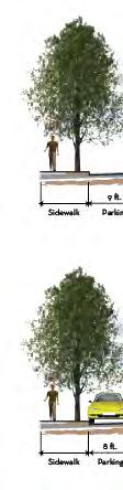
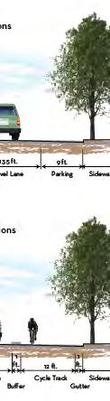
34 Sidewalk Sidewalk 8 ft. Parallel Parking 8 ft. Parallel Parking Sidewalk Sidewalk & Gutter Sidewalk Travel Lane 6 ft. Bike Lane 10.5 ft. 11 ft ft. 6 ft. Travel Lane 6 ft. 12 ft. Bike Lane 11 ft. 11 ft. 12 ft. Travel Lane 10 ft. Travel Lane Travel Lane Existing Conditions On-Street Parking 60 ROW Travel Lane Proposed Conditions On-Street Parking 60 ROW 12 ft. Travel Lane 2-Way Turn Lane Proposed Conditions No On-Street Parking 48 ROW Travel Lane 12 ft. 12 ft. Two-Way Left Turn Lane 11 ft. Travel Lane Existing Conditions No On-Street Parking 48 ROW 10 ft. Travel Lane Travel Lane Existing Conditions No On-Street Parking 40 ROW Proposed Conditions No On-Street Parking 40 ROW Travel Lane 11 ft. Travel Lane 12 ft. Bike Lane Travel Lane 10 ft. 10 ft. Travel Lane 6 ft. Bike Lane Travel Lane 8 ft. Parallel Parking 8 ft. Parallel Parking Sidewalk Sidewalk & Gutter Sidewalk HIGHLAND DRIVE ROAD DIET Figure Sugar House Business District Circulation Plan Sidewalk Sidewalk 1100 East Sugarmont Simpson Highland 2100 South 1200 East Wilmington N NOT TO SCALE I-80 LEGEND Sidewalk & Gutter 5 ft. 10 ft. Bike Travel Lane Lane 10 ft. 10 ft. Two-Way Left Travel Lane Turn Lane 5 ft. Bike Lane Sidewalk & Gutter Road Diet Extent
35 - Sugar House Business District Circulation Plan Table Highland Drive Road Diet Feasibility Criteria Project Relationship to Goals Mobility Benefits (ped/bike/veh /transit) Technical Constraints Improves bicycle In areas where the mobility street width is 40 Provides a safe, feet, bicycle lane attractive, and widths (five feet) functional pedestrian and travel lane environment to widths (10.5 feet) promote a walkable will likely need to be community less than standard Creates useable for Salt Lake City. connections to existing and future pedestrian and bicycle path systems Provides multi-modal transportation options Highland Drive Road that include transit, Diet bicycle and pedestrian +/+/0/0 1 facilities, as well as improved public streets to facilitate better mobility, access, and reduce traffic hazards Provides bicycle lanes where appropriate and feasible Evaluated the feasibility of making Highland Dr, south of 2100 South in the CBD a two-lane street, with a continuous center turn lane and angled or parallel onstreet parking Notes: 1 Represents a positive (+), neutral (0), or negative (-) impact for the respective travel mode. Source: Fehr & Peers, July 2012 Project Cost (low/med /high) In summary, the Highland Drive road diet would have minimal vehicular impact along the street and key intersections. Although the lane reduction would slightly increase average delay at the key signalized intersections, roadway segment delay would likely decrease due to the center turn lane that would exist which removes stopped turning vehicles from the travel lane. The road diet would also provide bicycle lanes which improve the multi-modal accessibility in Low July PROJECT EVALUATION 34
36 - Sugar House Business District Circulation Plan the Study Area. Also, by reducing travel lanes and providing a buffer (bicycle lanes) between the sidewalk and the vehicle travel lanes will create a better and more comfortable environment for pedestrians. The net supply of on-street parking remains the same in either condition. 4.4 Division of Large Blocks This section summarizes the feasibility of dividing larger blocks into smaller blocks within the Study Area. The evaluation of this division is a goal from the Sugar House Master Plan. Existing Conditions The Sugar House CBD consists of large blocks with minimal and/or undefined multi-modal connections to the existing street grid. The large blocks in the Study Area that need to the most improvement include: the Granite Block and the Sugar House Center block. Division of Large Blocks Large blocks can be divided into smaller blocks with defined pedestrian, bicycle, vehicular, and/or transit connections. Smaller blocks create better accessibility, walkability, and distribution of traffic, which results in an increase in mobility and a decrease in congestion. Figure shows the proposed division of blocks with pedestrian pathways (including trail systems and general walkways) and streets. The following Table summarizes the feasibility criteria for evaluation. July PROJECT EVALUATION 35

37 900 East Ramona Hollywood 2100 South Elm Sugarmont FAIRMONT PARK McClelland DIVIDING LARGER BLOCKS Figure Sugar House Business District Circulation Plan I East Simpson Highland 1200 East Wilmington 1300 East N NOT TO SCALE SUGAR HOUSE PARK LEGEND Pedestrian Path Street
38 - Sugar House Business District Circulation Plan Table Division of Large Blocks Feasibility Criteria Project Relationship to Goals Mobility Benefits (ped/bike/veh /transit) Technical Constraints Improves bicycle Collaboration with mobility property owners for Provides a safe, implementation attractive, and functional pedestrian environment to promote a walkable community Creates useable connections to existing and future pedestrian and bicycle path Division of systems Large Provides multi-modal +/+/+/+ 1 Blocks transportation options that include transit, bicycle and pedestrian facilities, as well as improved public streets to facilitate better mobility, access, and reduce traffic hazards Provides better multimodal connectivity Provides better internal access Divides large blocks into smaller blocks Notes: 1 Represents a positive (+), neutral (0), or negative (-) impact for the respective travel mode. Source: Fehr & Peers, July Addition of Bicycle Lanes on 2100 South Project Cost (low/med /high) Med to High This section summarizes the feasibility of adding bicycle facilities to 2100 South. Although the Study Area of this Plan is from 900 East to 1300 East, for this particular feasibility study the Study Area was expanded to include all of 2100 South within Salt Lake City boundaries South is a major road in the heart of Sugar House, connecting it to residential neighborhoods to the east, and residential, commercial, and industrial districts to the west. The roadway is July PROJECT EVALUATION 37


39 - Sugar House Business District Circulation Plan Evaluate the existing policy that prohibits cyclists from using the sidewalk in the Sugar House Business District and leaves the cyclist without a bicycle lane or path as an alternative; Ensure new land uses located adjacentt to bicycle routes require installation of street improvements, and provide bicycle lanes where appropriate and feasible; Provide safe bicycle routes to parks from residential areas, and establish a separate bicycle arterial system that connects Westminster College, the University of Utah, the Sugar House Business District, and other major destination points with one another; Use American Association of State Highway and Transportation Officials (AASHTO) and National Association of City Transportation Officials (NACTO) standards for bicycle lane width and signage for new construction; and use road construction projects as opportunities to upgrade existing bicycle lanes to meet these standards; Unite the parks and recreation areas with the open space trail system to develop a continuous bikeway system for intern; and intra-cityy travel for ecreation as well as alternative transportation Connect bicycle routes with regional trail systems in other jurisdictionss and neighboringg communities; Support the elimination of on-street parking on one side of roadways to allow the addition of bicycle lanes; and Provide bicycle racks and lockers at destination points and at transit terminals; Enhance pedestrian crossings along 2100 South; Pedestrians should have the right-of-way over all other modes of transportation; Use a landscaped area to provide a buffer zone owned by Saltt Lake City. Several goals and statements within the Sugar House Master Plan relate to this topic in various ways, including: Provide for multiple modes of transportation that are safe, convenient, and comfortable; Provide a pedestrian and bicycle circulation plan and identify the right-of-way necessary to support multi-modal alternatives; A pedestrian first zone, reducing travel distances encourages safer and increased levels of bicycling and walking; July PROJECT EVALUATION 38
40 - Sugar House Business District Circulation Plan Existing Conditions In the heart of Sugar House, 2100 South is a four-lane roadway with an occasional center turn median. The roadway has variable characteristics along its length between 300 West and Parley s Way, which represents the majority of the urban roadway. Table identifies major segments of the roadway and their characteristics. Segment No. of Lanes Sidewalks Parkstrip Table South Characteristics On-Street Parking ADT West to 200 East 4 Yes No No 18, East to 700 East 4 Yes Yes No 17, East to 900 East 4 Yes Yes No 26, East to 1300 East 4 Yes Yes Some 25, East to 1700 East 5 Yes Yes North side only 22, East to 2100 East 4 Yes Yes No 19, East to Parley s Way 4 Yes Yes No 15,000 2 Notes: Average Daily Traffic data from UDOT s Traffic on Utah Highways Average Daily Traffic from Salt Lake City Transportation Division Source: Fehr & Peers, July 2012 Accommodating Bicycle Lanes Salt Lake City could pursue several options for accommodating bicycle lanes on 2100 South. These include removing a traffic lane (also known as a road diet ), removing on-street parking, widening the roadway, or establishing a shared bicycle/vehicle/transit on outside lanes. These options are outlined in Table Alternatives Add bicycle lanes through a Road Diet on 2100 South Table South Possible Bicycle Lane Alternatives Technical/Safety Constraints Road diets for a four-lane to three-lane cross section can generally be successful with volumes up to 20,000 ADT depending on the application; see Table for 2100 South ADT. Intersection at 2100 South and 700 East is frequently congested with high right-turn volumes. Potential delay for bus routes if congestion increases. East of 1300 East, a road diet is feasible in the eastbound direction by replacing the outside travel lane between 1300 East and 1700 East with an uphill bicycle lane. A cycle track is also a possibility in this segment. This alternative is not likely west of 1300 East. Project Cost (low/med /high) Low July PROJECT EVALUATION 39
41 - Sugar House Business District Circulation Plan Alternatives Remove onstreet parking to add bicycle lane Shared bicycle/vehicle outside lane Widen roadway to accommodate bicycle lanes Widen the sidewalk to better accommodate cyclists 1 Table South Possible Bicycle Lane Alternatives Technical/Safety Constraints On-street parking is only present in limited sections of 2100 South (see Table 4.1-8). Removes buffer between pedestrians and travel lanes. Potential for bus conflicts across bicycle lanes. Street lights would need to be relocated as well as parkstrip trees. Current on-street parking levels would need to be analyzed further to determine utilization. Frequent right turns and intersections create possible safety hazards. Additional cost and building acquisition associated with widening between 600 East and 1300 East. Right-of-way may be available between 200 East 600 East and east of 1300 East via removal of on-street parking or road diets. Additional cost and building acquisition associated with widening sidewalks between 600 East and 1300 East. Some street lights would need to be relocated. Some parkstrips would need to be removed. Conflicts between pedestrians and cyclists on the sidewalk. Safety issues with vehicles entering/exiting driveways, not expecting to see cyclists on the sidewalk. Notes: 1 While this is not a typical preferred solution, it should be noted that bicycle counts conducted at the intersection of 1100 East and 2100 South revealed that 53 80% of the cyclists traveling through that intersection were on the sidewalk. Source: Fehr & Peers, July 2012 Project Cost (low/med /high) Medium 200 East to 600 East Conclusion It is feasible to add a bicycle lane through elimination of on-street parking between 200 East 600 East on both sides of the street. Considerations Further evaluate the necessity of on-street parking for businesses and residences throughout these areas. Safety concerns from a shared bicycle lane and bus stops would need to be addressed. Low High High July PROJECT EVALUATION 40

42 - Sugar House Business District Circulation Plan 600 East to 1300 East Conclusion An on-street bicycle facility is not recommended in this section, due to high traffic volumes and inadequate width for cyclists. Salt Lake City should support finding other east-west alternates for cyclists, such as Westminster Avenue or the proposed Parley s Trail. A road diet is not recommended based on the daily traffic volumes. Considerations Percentage of total bicycles on 1100 East and 2100 South using the sidewalk ranged from 53% - 80%. The option of allowing cyclists to ride on the sidewalk is unconventional, but reflects the trends that are already occurring on the corridor. Given that these behaviors are already taking place, Salt Lake City may wish to consider safety treatments that alert motorists to the potential presence of cyclists on the sidewalk East to 1700 East Conclusion A road diet is feasible on eastbound 2100 South between 1300 East and 1700 East, which will allow space for a buffered bicycle lane. Narrowing westbound vehicle and parking lanes can provide adequate space for a westbound bicycle lane as well. These can be accomplished without major resurfacing of the roadway. Space reallocations are demonstrated in the following cross-sections. July PROJECT EVALUATION 41
43 - Sugar House Business District Circulation Plan Considerations A two-way cycle track is also feasible on the south side of 2100 South if the existing outside eastbound lane is removed. Cycle track alignments would not continue west of 1300 East or east of 1700 East. Cycle track treatments would need to transition at these intersections to match bicycle treatments in adjacent roadway segments. Intersections between 1300 East and 1700 East will require special treatments as well in order to accommodate a cycle track East to 2300 East Conclusion It is feasible to add a bicycle lane in both directions by instituting a road diet, through eliminating the outside travel lane and adding bicycle lanes plus a center turn lane. Another option would be to establish outside shared lanes eastbound and westbound, using shared lane markings and Bikes May Use Full Lane signage. Considerations Any transition between bicycle treatments on the corridor (bicycle lanes vs shared lane markings) will need to be carefully designed to minimize confusion and enhance bicyclist safety. Salt Lake City should conduct a traffic analysis to verify that a road diet will not result in undue traffic congestion in this corridor; it is possible that the surrounding neighborhoods will voice concerns regarding cut-through traffic. It is recommended that the City perform public outreach prior to implementation of a road diet. Safety concerns from a shared bicycle lane and bus stops would need to be addressed. Logical termini for bicycle lanes on 2100 South is 2300 East due to the presence of bicycle lanes on this roadway; adequate space may exist east of 2300 East to accommodate a bicycle lane on the shoulder, but the roadway eventually transitions into a freeway on-ramp without space for cyclists. Other logical connections east of 2300 East may be considered if bicycle lanes were to continue further. 4.6 Parley s Trail Connection This section summarizes options for a Parley s Trail alignment between the Fairmont Aquatic Center (located on Sugarmont Avenue and McClelland Avenue) and Hidden Hollow Park (located west of 1300 East and north of Wilmington Avenue). Establishing a Parley s Trail connection meets several goals from the Sugar House Master Plan, such as: Provide for multiple modes of transportation that are safe, convenient, and comfortable; July PROJECT EVALUATION 42
44 - Sugar House Business District Circulation Plan Provide a pedestrian and bicycle circulation plan and identify the right-of-way necessary to support multi-modal alternatives; Provide safe bike routes to parks from residential areas, and establish a separate bicycle arterial system that connects Westminster College, the University of Utah, the Sugar House Business District, and other major destination points with one another; Unite the parks and recreation areas with the open space trail system to develop a continuous bikeway system for inter- and intra-city travel for recreation as well as alternative transportation; and Connect bike routes with regional trail systems in other jurisdictions and neighboring communities. Planning Context Several factors must be considered when evaluating options for the Parley s Trail in this section. These include adjacent Parley s Trail sections and their design treatments, potential transportation investments in the area, and development plans for private property parcels in the section under study. Adjacent Trail Sections West of McClelland Avenue, the Parley s Trail is planned for co-location with the Sugar House Streetcar, generally within the UTA right-of-way. East of Hidden Hollow, a tunnel (The Draw) will soon be under construction at 1300 East which will connect trail users from Hidden Hollow to Sugar House Park, and to trail links eastward from there. The trail from Hidden Hollow to 1700 East will be paved for use by both bicyclists and pedestrians, but separated from vehicles. Potential Transportation Investments Two potential transportation investments between McClelland Avenue and Hidden Hollow are noteworthy for the Parley s Trail. First, Salt Lake City has, for some time, considered realigning Wilmington Avenue with Sugarmont Drive. Both roads terminate at Highland Drive, and currently do not align. A realignment of these two roads could potentially join the two roadways together and create better accessibility of traffic in the Sugar July PROJECT EVALUATION 43


 TRAX Station to McClelland Avenue, and began construction in spring 2012.")
45 - Sugar House Business District Circulation Plan House area (see Section and the figure above). It could establish an on-street Parley s Trail alignment, placing trail users on bike lanes and pedestrians on sidewalks to connect between McClelland Avenue and Hidden Hollow. However, realignment is not feasible in the short-term, but could be more viable in the mid- to long-term as redevelopment continues along Sugarmont Drive and land is acquired on the Granite Block. Since the realignment is not considered feasible in the short-term future, it is also not currently available as an option for the Parley s Trail. Another potential transportation investment in the area is Phase Two of the Sugar House Streetcar. Phase One of the Sugar House Streetcar extends from the 2100 South (Central Pointe) TRAX Station to McClelland Avenue, and began construction in spring An extension (Phase Two) is currently under consideration, and would take the streetcar eastbound from McClelland onto Simpson Avenue, north on Highland Drive to the monument at 2100 South, returning south on Highland Drive to Sugarmont Avenue, and westbound on Sugarmont Avenue to McClelland Street and onward. The following figure illustrates the locally preferred alternative (LPA) alignment for the streetcar in this area. An eventual streetcar extension along 1100 East to 1700 South may be considered in the future. Sugarmont Drive, currently a oneway road westbound with on-street space for bicyclists and pedestrians, would be closed to vehicles other than the streetcar. Development Plans As previously discussed in Section 2.1.2, several major redevelopment projects are progressing in the Sugar House area. This includes Wilmington Gardens between Highland Drive and 1300 East north of Wilmington Avenue, and Sugar House Center between Highland Drive and 1300 East, south of Wilmington Avenue. Both projects involve developers who are supportive of the Parley s Trail concept and bicycle and pedestrian facilities in general. The Wilmington Gardens project will establish a bicycle-specific trail on the east edge of their project to accommodate cyclists exiting Hidden Hollow using the Parley s Trail, while pedestrians may connect from the trail in Hidden Hollow to Wilmington Gardens from a pedestrian plaza and corridor in the center of the project. Development plans at the Sugar House Center are in a preliminary stage, and will become more detailed after this Plan is complete. Recommendations and Considerations The recommendations for the Parley s Trail are shown in Figure Specific improvements associated with the recommendations include: July PROJECT EVALUATION 44
46 - Sugar House Business District Circulation Plan Parley s Trail users can use planned separate connections in the Wilmington Gardens project to travel between Wilmington Avenue and Hidden Hollow: bicyclists using the trail on the eastern edge of the property, pedestrians through the corridor and plaza in the center of the project. Existing bicycle lanes on Wilmington Avenue should be restriped, including accommodations for cyclists to make left turns at both ends of the corridor. Bicycle detector loops should be considered. For the near future, trail users should use Wilmington Avenue and Highland Drive to connect to the Sugar House Streetcar greenway on Sugarmont Drive. Salt Lake City should continue discussions with the developers of the Sugar House Center to establish pedestrian corridors linking from Wilmington Gardens to Sugarmont Drive. July PROJECT EVALUATION 45


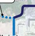
47 PARLEY S TRAIL CONNECTION Figure Sugar House Business District Circulation Plan N NOT TO SCALE Ramona Hollywood Wilmington Gardens link to Parley s Trail / 2100 South Hidden Hollow Elm Install HAWK beacon at Sugarmont / Highland SUGAR Intersection HOUSE Wilmington PARK Sugarmont Simpson Coordinate with developers to establish trail connections FAIRMONT PARK Intersection striping to accommodate LEGEND cyclists on Wilmington, connecting to I-80 Parley s Trail in Sugar House park. Parley s Trail Consider placing a bike detector. Potential Parley s Trail Connections Short-Term Bicycle and Pedestrian Short-Term Pedestrian Only Long-Term Bicycle and Pedestrian Long-Term Pedestrian Only Potential Redevelopment 900 East 1100 East Highland 1200 East 1300 East
48 - Sugar House Business District Circulation Plan A HAWK beacon at the intersection of Sugarmont Dive and Highland Drive is recommended; this would ideally connect interior pathways at the Sugar House Center to the Sugar House Streetcar and greenway. This will become more critical as pedestrian connections are established through the Sugar House Center and if the proposed streetcar line extends to Highland Drive. Adequate space exists on Sugarmont Drive, with roughly 35 feet of right-of-way, to accommodate both the streetcar and the Parley s Trail along the streetcar s south side. The turning radius for the streetcar may necessitate more space from the trail area; if this is the case, the trail could be shifted slightly southward into property owned by Salt Lake City that is planned for redevelopment. 4.7 Raised Street Level on Highland Drive This section summarizes the feasibility of raising the street level of Highland Drive between Sugarmont Drive and Simpson Avenue. The evaluation of this project was recommended by RDA staff. Existing Conditions Highland Drive has a four-lane cross section between Sugarmont Drive and Simpson Avenue and has a posted speed limit of 30 mph. The ADT on Highland Drive is approximately 21,200. Raised Street Level A raised street would consist of raising the street level to the same elevation as the sidewalks and future proposed plazas in the area. With the redevelopment of the Sugar House Center and the Deseret Industries block, as well as the proposed plaza at Sugarmont the raised street level could tie all the developments and plazas together creating a synergy between them, the plazas, and Farimont Park. As previously discussed, this is also the proposed location for the Parley s Trail connection. The streetscape and amenities plan should provide further evaluation of this project. The following Table summarizes the feasibility criteria for evaluation. July PROJECT EVALUATION 47
49 - Sugar House Business District Circulation Plan Project Table Raised Street Level on Highland Feasibility Criteria Relationship to Goals Mobility Benefits (ped/bike/veh /transit) Technical Constraints Improves bicycle mobility Streetcar design (going up and down Provides a safe, attractive, and the elevation change) functional pedestrian environment to promote a walkable community Bollards (or something similar) may need to be placed on either end Creates useable connections to existing to visually segregate pedestrian plazas Raised and future pedestrian from the raised Street and bicycle path street area +/+/0/0 Level on systems Highland Provides multi-modal transportation options that include transit, bicycle and pedestrian facilities, as well as improved public streets to facilitate better mobility, access, and reduce traffic hazards Provides better multimodal connectivity Notes: 1 Represents a positive (+), neutral (0), or negative (-) impact for the respective travel mode. Source: Fehr & Peers, July 2012 Project Cost (low/med /high) Med to High July PROJECT EVALUATION 48


50 - Sugar House Business District Circulation Plan 5.1 CHAPTER 5: IMPLEMENTAT TION PLAN Proposed Improvements Specific Locations The figure below illustrates locations where opportunities for specific improvements were identified. A series of Project Sheets follow that correspond with map locations. It should be noted that the improvements shown on some of the Project Sheets can serve as prototypical improvements that could be applied at other locations. Also note that currently no safety studies have been conducted in these locations. These studies, along with greater examination of drainage and parking impacts, are necessary before making any determination on how to proceed. This Plan was a collaborative effort to prepare a timeline for implementing projects in the short-term ( ), mid-term ( ), and long-term (beyond 2020). Conceptuall projects weree established based on input from the project stakeholders, the Sugar House Master Plan, and feasibility studies (including technical analysis) presented in Chapter 4. July IMPLEMENTATION PLAN 49


51 - Sugar House Business District Circulation Plan 5.2 A. Mid-Block Crossings Wilmington Avenue Existing Site Characteristics Design Recommendations Possible Concerns Currently, there is one mid-block crossing on Wilmington near Highland and a crosswalk at the intersection of Wilmington and East. The nearest crossing point to the proposed crossing area is 250 feet away. Wilmington Avenue is a low-volume road. Improve visibility throughh signage and striping Possibly raise crosswalk and texture Cost may be associated with development projects As development occurs along Wilmington, roadway volumes may increase. July IMPLEMENTATION PLAN 50


52 - Sugar House Business District Circulation Plan B. McClelland at Elm BEFORE Existing Site Characteristics Design Recommendations Currently, there is one mid-block crossing on McClelland Street, 230 feet north. McClelland Street is a low-volume road,, with a number of development plans along both sides. A Sugar House Streetcar station will be located 375 feet south of this intersection Improve visibility throughh signage and striping Possibly raise crosswalk and texture Possible Concerns Conflict with proposed cycle track and trail users. n. AFTER July IMPLEMENTATION PLAN 51


53 - Sugar House Business District Circulation Plan 5.3 C. HAWK Beacons 2100 South at 1200 East (already funded by the City) Existing Site Characteristics Design Recommendations Possible Concerns The crossing features flags for pedestrians to use to increase visibility on both approaches. UTA bus stop is close to crosswalk. Westminster sees 1200 East as a pedestrian connection to the college. Improve visibility of crossing through electronic signals. Ability to retain street trees. July IMPLEMENTATION PLAN 52


54 - Sugar House Business District Circulation Plan D. Highland at Sugarmont Existing Site Characteristics Signalized crossings are located 170 andd 220 feet away. Design Recommendations Possible Concerns Will becomee a crossing for the Parley s Trail, currentlyy being constructed alongsid Sugar House Streetcar. Connects Sugar House Park and Fairmont Park. Construct a HAWK beacon to facilitate trail users and streetcar riders. Spacing to the Wilmington and Simpson traffic signals. de the July IMPLEMENTATION PLAN 53


55 - Sugar House Business District Circulation Plan 5.4 E. Road Diet Highland Existing Site Characteristics Design Recommendations Possible Concerns Highland Drive is currently two lanes in each direction with pockets of on-street parking. Delay occurs as drivers wait in- lane to turn left. From 2100 South to Stringham Avenue, convert roadway into one lane in each direction, with a center turn lane, and bike lanes in both directions. Maintain on-street parking where it exists. An increase in ADT with less capacity as future developments come on line in the Study Area. July IMPLEMENTATION PLAN 54


56 - Sugar House Business District Circulation Plan 5.5 F. Plazas Monument Plaza Existing Site Characteristics Design Recommendations Possible Concerns Stop-controlled, eastbound right-turn bay. Plaza area with monument, bus stop, and trees. Angled parking along south side of right-turn bay. Close Plaza to automobile traffic and remove parking. Provide space for streetcar to enter plaza in short-term and for streetcar station in long-term. Make plaza space at one, consistent level. Allow fronting development to use Plaza as sitting and dining space. Removal of trees. Removal of 18 on-street parking stalls. Loss of exclusive eastbound right-turn lane. Could increase vehicular delay and eastbound queue length. July IMPLEMENTATION PLAN 55


57 - Sugar House Business District Circulation Plan G. Sugarmont between McClelland and Highland Existing Site Characteristics One-way, westbound traffic with bike lane. Provides access for returning fire department vehicles. Design Recommendations Possible Concerns Close Sugarmont to automobile traffic, with exception for fire department vehicle Provide space for streetcar and Parley s Trail users. Make plaza space at one, consistent level. Allow fronting development to use Plaza as sitting and dining space. None es. July IMPLEMENTATION PLAN 56


58 - Sugar House Business District Circulation Plan 5.6 H. Bicycle Lanes Highland Existing Site Characteristics Design Recommendations Possible Concerns Highland Drive is currently two lanes in each direction with pockets of on-street parking. There are no bicycle lanes. From 2100 South to Stringham Avenue, convert roadway into one lane in each direction, with a center turn lane, and bicycle lanes in both directions. Maintain on-street parking where it exists. None. July IMPLEMENTATION PLAN 57


59 - Sugar House Business District Circulation Plan I. McClelland from 2100 South to Sugarmont Existing Site Characteristics Design Recommendations Possible Concerns One travel lane in each direction with unsigned on-street parking. No striping on roadway. Low traffic volumes set to increase with redevelopment on both sides of roadway. Future alignment for Jordan and Salt Lake Canal Trail. Two-way cycle track on east side of roadway. Cycle track minimum width of 12 feet. Parking in one direction should be maintained. Physical buffer separation from vehicular traffic. Driveway/minor street crossings. Entering/exiting cycle track. July IMPLEMENTATION PLAN 58


60 - Sugar House Business District Circulation Plan 5.7 J. Pedestrian Connectio ons Various Locations Existing Site Characteristics Design Recommendations Possible Concerns A number of large developments with limited inviting pedestrian spaces and large parking lots. Create clearly delineated and signed pedestrian pathways through large blocks. As part of the development review process for new developments/reuse of existing developments, encouragee the constructionn or conversion of larger blocks into smaller blocks separated by a network of narrow, short streetss and/or pedestrian and bicycle corridors. None. July IMPLEMENTATION PLAN 59

61 - Sugar House Business District Circulation Plan 5.8 New Roadways K. Wilmington Extension Existing Site Characteristics Wilmington Avenue exists from 1300 East to Highland Drive. Current configuration is one lane in each direction with bike lanes. Design Recommendations Extend Wilmington through Granite Block to Sugarmont at intersection of McClelland. One travel lane in each direction with bike lanes and on-street parking. Possible Concerns Intersection at McClelland/Sugarmont/Simpson. Development potential of parcels. BEFORE AFTER July IMPLEMENTATION PLAN 60

62 - Sugar House Business District Circulation Plan L. Simpson Extension Existing Site Characteristics Simpson currently exists from McClelland to Highland. Current configuration is one lane in each direction. Design Recommendations Extend Simpson from Highland through Sugar House Center to 1300 East. One travel lane in each direction with on-street parking. Possible Concerns Intersection at 1300 East will likely be restricted to right-in right-out movements only. BEFORE AFTER July IMPLEMENTATION PLAN 61


63 - Sugar House Business District Circulation Plan 5.9 M. Parley s Trail Sugar House Connection n Existing Site Characteristics Design Recommendations Possible Concerns There is no planned connection between McClelland Street (end of Greenway corridor) and the Draw (at 1300 East between 2100 South and Wilmington). In short term, connect the Trail on-street via Wilmington, which has on-street bicycle lanes and sidewalks on both sides. The Wilmington Gardens development has planned connections, both pedestrian and bicycle, for the Parley s Trail. In long term, work with Sugar House Center developers to accommodate trail with possible redevelopment opportunities. Wayfinding. Ability to integrate trail into development plans. July IMPLEMENTATION PLAN 62


64 - Sugar House Business District Circulation Plan 5.10 N. Intersection Improvem ments 2100 South/Highland Eastbound Right-Turn Closure Existing Site Characteristics Design Recommendations Possible Concerns The current eastbound configuration att the intersection of 2100 South and Highland is one left turn lane, two through lanes, and one right-turn lane. Right-turn lane is stop controlled and separated from the main intersection. The existing right-turn lane is on the south side of Monument Plaza. Close right turn lane to vehicular traffic and parking. Eastbound movement would become one left turn lane, one through lane, and one shared through-right turn lane. Small increase in overall delay at intersection. More substantial increase in eastbound delay. Loss of 18 on-street parking stalls. Extended queue lengths eastbound on 2100 South. July IMPLEMENTATION PLAN 63


65 - Sugar House Business District Circulation Plan O. Northbound Approach Improvements at 2100 South/Highland Existing Site Characteristics The current northbound configuration at the intersection of 2100 South and Highland is one left turn lane, one through lane, and one right-turn lane. Right lane is a trap lane, meaning all traffic in the right lane must turn right. Left turn lanes consistently exceeds storage lane, blocking northbound traffic. Design Recommendations Reconfigure northbound approach so that the left lane turns into a left-turn trap lane. Northbound right would become a turn pocket. Possible Concerns This configuration is only applicable prior to the implementation of the proposed Highland Drive road diet. July IMPLEMENTATION PLAN 64
66 - Sugar House Business District Circulation Plan CHAPTER 6: Next Steps The City should undertake a prioritization and costing exercise beyond the scope of this Plan. In setting its priorities, the City should consider how these recommended projects help to achieve its circulation goals. The City should continue its engagement of property owners to help implementation the projects which are located on private property. Additional analysis may be needed for projects that could have a significant and unequal impact to certain modes. Salt Lake City should identify a variety of funding sources to construct the recommended projects described in the implementation section of this Plan. July Next Steps 65

67 CHAPTER 7: COMPLETE STREETS/STREETSCAPE AMENITIES An opportunity for incorporating the Complete Streets concept is arriving in Sugar House. The streets within the Sugar House redevelopment area are transforming from an automobile intensive use and design to a multi-modal intensive use. This document introduces the Complete Streets concept, evaluates the current streetscape amenities within the Sugar House Business District, and then establishes a set of streetscape design standards to better accommodate this multi-modal use and guide the renovation to a Complete Streets environment. The objective is to document existing resources, discuss how to build off and incorporate existing amenities into an overarching Complete Streets design, evaluate opportunities to enhance and unify the design theme and to replace amenities that have served their lifecycle or are outdated and underperforming. Background The Sugar House Master Plan states, The Business District can be improved in terms of making it a more pedestrian-oriented experience. The City needs to think pedestrian first when approving new developments or when implementing its own public works projects. This includes pedestrian circulation between blocks and within individual developments. It is essential that pedestrian crossings on 2100 South are added and the existing crossings are enhanced. Furthermore, implementing a pedestrian first policy for the Business District to ensure the pedestrian is given priority consideration when developing new projects or programs is recommended. The nationally recognized Complete Streets approach will assist with fulfilling the desired Master Plan goals. Complete Streets Concept Sugar House Monument photo by: Clint Gardner, creative commons license Complete Streets are roadways designed to promote and implement safe, attractive, and comfortable access and travel for all user types, ages and abilities. Implemented through planning and urban design policy, Complete Streets are ideal tools for redevelopment areas. A Complete Street is a roadway with accommodations provided for pedestrians, cyclists, automobiles, and, where applicable, Sugar House Streetscape Amenities - 1

68

69 mass transit. Connectivity, inclusive user accommodations, neighborhood character and quality of life are the defining attributes of a Complete Street. In contrast to roadways that function solely as an automobile thoroughfare, a Complete Street functions as more of a place and experience. The Complete Street User The user of a Complete Street can take the form of differet types of mobility: pedestrians, cyclists, streetcars, buses and automobiles. Complete Streets utilize design and amenities to make streets and the surrounding streetscape safe and accessible to the needs of these different mobility types. Connectivity and the aesthetics of the streetscape environment are key factors for creating a Complete Street experience, especially for pedestrians and bicyclists. Welldesigned streets allow motorists and public transportation modes to efficiently use the street without impeding or endangering other user groups. Complete Streets Features It is not just the design of the space from curb to curb that define the context of Complete Streets. The surrounding environment, from the architecture to the streetscape amenities, plays a large role in establishing a Complete Streets context. The design of Complete Streets incorporates multiple components of the streetscape, including: Street Dimensions & Configuration Sidewalk Dimensions & Configuration Amenities & Aesthetics Spatial Definition photograph by: CRSA We shouldn t just use some antiquated language that says we have to post the speeds according to what 85 percent of motorists are doing. Instead we should take control of our streets. If 85 percent of our motorists are driving faster than we want them to, then we need to redesign the street, rather than letting the tail wag the dog. There s something wrong with our street design if you re getting 85 percent of our motorists to drive 10 miles an hour faster than is safe for the conditions. -Dan Burden, Executive Director of Walkable Communities, Inc. Sugar House Streetscape Amenities - 3


70 Street Dimensions & Configuration The curb to curb travel areas of Complete Streets include designated or shared-use lanes for bicyclists and transit modes. In contrast to regular streets, Complete Streets incorporate components in the street space that may include narrower travel lanes, landscaped medians, and on-street parking. A key indicator of a Complete Street is the designation of bicycle lanes or shared-use lanes. Shared lanes allow for both auto and bicycles to use the travel lane while dedicated bicycle lanes separate the users. Dedicated bike lanes also provide protection for cyclists and encourage bike use. The travel way is enhanced and defined through the use of raised crosswalks, intersection designs, colored multi-use travel lanes and decorative paving. Street width is defined as the physical curb-to-curb space. Effective width can be defined by amenities that promote a Complete Streets environment, such as on-street parking, bike lanes, painted edge lines, or bulb-outs. The edges of travel ways are spatially defined through the use of amenities such as street trees, planted park strips, and bollards. These elements all work to create a safe and inviting environment designed for multiple users. Improvements can be made in the existing street infrastructure to create a Complete Streets context. Bike and pedestrian corridors are an effective strategy for creating more walkable, dense development environments. The addition of these corridors can create smaller blocks without adding additional automobile streets. This facilitates a higher degree of connectivity by creating more permeability among the development environment. Provision of pedestrian and bike only corridors allows them to flow through the network without needing to use busier streets. photograph by: CRSA photographs by: CRSA 4 Sugar House Streetscape Amenities -


71 Sidewalk Dimensions & Configuration Complete Streets sidewalks function as more than just pedestrian walkways. When strategically designed, sidewalks become outdoor living rooms, where people eat, work, play and experience the public realm. Components of the sidewalk space can include outdoor dining, decorative planter boxes, street trees, outdoor retail space to extend store fronts, vendor kiosks, food carts, and lighting. At the corners of sidewalk space, bulb-outs extend the pedestrian space and act as buffers from faster moving traffic. Amenities & Aesthetics While in many city features form does follow function, good design can also be both aesthetic and functional. Textured streets, landscaping, building form and material, sidewalks and crosswalks enhance the aesthetic to a Complete Street system. Complete Street design helps to create a place and is inviting to all users. Besides the environmental and sustainable features, trees also bring design aesthetics to the streetscape. Visually speaking trees add vertical and spatial dimension to street spaces. Street trees help make up the urban forest ecology photograph by: CRSA photograph by: CRSA Sugar House Streetscape Amenities - 5

72 within cities. Tree diversity is a critical practice to maintain healthy urban forests. While consistent themes and design are important to the street aesthetic, this doesn t mean that all the trees and shrubs need to be mono-culture in species selection. Spatial Definition The spatial definition of the street helps to frame the perspectives of the users. In addition to buildings that are designed to shape the street with their massing, form, and orientation, other elements can define these spatial ratios. These include amenities that are part of the Complete Streets context, such as street trees, landscaping, and public art or monuments. (See Figure 1) The best current example of this in the SHBD is the Sugar House Monument, which contributes to defining the spatial form of the street and enhances the area around the intersection of 2100 South and Highland Drive. Figure 1: While spatial form is often best defined by primary building facades, landscaping and stepbacks/recessed facades also are elements that define the street. photograph by: CRSA 6 Sugar House Streetscape Amenities -


73 Existing Amenities The collection of existing streetscape amenities in the SHBD are representative of past and current efforts to improve the experience of people who come to Sugar House to shop, eat, work, and play. In this section, documentation of the existing amenities that define the Sugar House Business District streetscape are catalogued. Following are recommendations for which of these amenities can play a role in defining the Complete Streets context of the SHBD, and how they can be supplemented/improved upon. The following categories define the different types of streetscape amenities found in the SHBD: Hardscape Softscape Lighting & Signage Furniture & Fixtures Art & Culture Hardscape Decorative Paving Two types of decorative paving are currently used in the streetscape of the SHBD. The predominant type is a red, textured pavement. This textured paving material has been used in the most recent updates to areas of the SHBD, including the monument plaza, corner treatments, and bulb outs. The other type is a smooth surface, red brick. This treatment was installed along the north side of the Granite Block as sidewalk material. However, the smooth surface becomes slick when wet and snowy, leading to unsafe pedestrian conditions. Red Textured Paving Smooth, red brick pavers and Street trees Sugar House Streetscape Amenities - 7


74 Textured pavement locations include the Monument Plaza, areas along 2100 South, 1100 East, and Highland Drive. Bulb-outs Bulb outs are used to narrow the crossing distance and/or to act as traffic calming devices. They also define areas of on-street parking. Locations include 1100 East, Highland Drive, and 2100 South. Crosswalks The majority of cross walks in the SHBD are the standard striped crosswalk, defined by two parallel white painted lines. In a few locations, the more visible zebra striping pattern is used. Overhead, pedestrian-activated crossing lights are located at the McClelland crosswalk on 2100 South. Additionally, orange pedestrian flags are located there and at the mid-block crosswalk just north of 2100 South on 1100 East. Recommendations: Although the textured paving is fairly recent, the city should consider updating the paving scheme as the monument plaza and Granite Block are reconfigured. The smooth pavers should be replaced with a more durable, safe surface. Bulb-outs should be retained, although the paving material may be updated to be consistent with the monument plaza. Crosswalks should be updated with textured pavement or zebra striped lines to enhance visibility. Additional crosswalk enhancement may include HAWK lights at key locations. Bulb-out for on-street parking Striped Crosswalk and Street Trees Crosswalk with pedestrian-activated lights 8 Sugar House Streetscape Amenities -


75 Softscape A variety of landscaping and other softscape treatments work to enhance the SHBD. Street Trees Street trees have been in place in the SHBD since improvements done in the 1980s. In more residential areas surrounding the SHBD, mature trees also line the street. The primary tree used in the central SHBD is the honey locust. Tree Grates Tree grates are used around street trees where the surrounding surface is hardscape. Park Strips A planted park strip separates the sidewalk from the street and contains street trees. Most areas that are not hardscaped incorporate a planted park strip. Plantings Plants are located in the base of the monument as well as in low concrete planters in a few locations on the plaza and in front of the Granite Furniture building. Recommendations: Select replacement of some street trees may be in order. The lifespan of the honey locust species is near its typical end. The varieties should be selected so that their canopies are of a height that maintains unobstructed passage of different user types, including vehicles and pedestrians and bicyclists. Spacing between trees and from buildings and Concrete planter Planted park strip and street trees Sugar House Streetscape Amenities - 9


76 other structures should be designed to allow for full canopy growth. Careful consideration should be given regarding the location of street trees in front of businesses so as not to obstruct signage or building identification. Tree grates may need to be replaced as street trees are reconfigured or replaced. Those that remain should be evaluated and repaired when necessary. Retention and enhancement of the planted park strip is recommended to maintain the softscape elements that convey a pleasant environment and balance the predominant hardscape of the street and plaza areas. Plantings should remain in the base of the monument. Previous evaluation of the re-installation of the water feature was not recommended due to damage the water caused the monument structure. Additional planters should be located throughout the SHBD. Lighting & Signage Street lights in the SHBD are primarily a black metal pole with teardrop light fixtures. The lights include a pair of lower pedestrian-scaled fixtures and a pole for hanging banners. The base includes lettering for Sugar House and a sugar beet emblem. These have been installed throughout the SHBD over the past decade. This lighting fixture was chosen in response to SHBD Design Guidelines, which called for the following specifications: Choose light poles, arms, and fixture designs to preserve the historic character of the streetscape. Select lighting to be in scale with the pedestrian experience. Signage in the SHBD is primarily of two different types. Concrete gateway signs with metal lettering that say Sugar House are located at entrance points to the SHBD. These are of two different eras and the newer versions have slightly different lettering than the originals. Wayfinding signage is lcoated throughout the SHBD. This signage has a blue and orange flat surface with arrows indicating the direction of local attractions. The signs are mounted on a brown metal frame. Black street lights with banner poles Wayfinding Signage and concrete planters 10 Sugar House Streetscape Amenities -


77 Recommendations: The street lights currently in place are recommended to remain. Some are in need of repair, and regular maintenance is necessary to maintain a safe environment and clean appearance. The addition of accent lighting is recommended to enhance seating areas and softscape elements. The signage theme for the SHBD should be unified. The concrete gateway signs have some historical significance and should likely remain. However, updates to match the style and font of the lettering on the signages is recommended. The wayfinding signs are not necessarily representative of a Sugar House color scheme. If one is identified, these signs should be updated/replaced to be consistent. Furniture & Fixtures A variety of furniture and fixtures serve as amenities in the SHBD. These include transit canopies/shelters, benches, bike racks, bollards, and trash cans. The transit canopies date back to the 1980s. These are located on the monument plaza and in front of Sprague Library. Benches are primarily located on the monument plaza and consist of a treated wood product with metal arms/legs. Additionally, there are several concrete couches that were installed as a public art commission that serve as bench seating. Bike racks are located throughout the SHBD. The type and design vary. Bollards are used in the main area of the SHBD to serve as barriers between pedestrians and the traffic lanes. The majority are a black metal bollard that is similar in style to the street lights. A few older concerete bollards remain on the north side of the Granite Block. Black metal bollard and tree grate Transit Canopy on monument plaza Sugar House Streetscape Amenities - 11


78 Trash cans are located throughout the SHBD. These are pebbled concrete and brown metal, and square in configuration. Recommendations: The transit canopies are in need of replacement. While functional, they don t indicate the importance of transit users to the area. When amenities are provided at transit stop areas, the area is more immediately defined as a Complete Street environment to users of all types. Well-designed canopies with benches signal that the transit user is an integral and expected component of the Complete Street environment. Amenities that make the transit stops a comfortable place to sit and wait are a necessity. The location of the canopies and benches at transit stops need to be located far enough from the travel lanes to create a safe and comfortable space. The fixed-in-place benches are not frequently used, except during special events located around the monument plaza. Movable seating is recommended to replace or complement fixed benches. Seating opportunities should incorporate a range of options beyond benches and chairs. Low walls, planters, steps, and fountain edges. These additional elements function not only as seating, but also amenities that improve the aesthetics of an area and establish its niche as a public space. The current black metal bollards may continue to work, but replacement should be considered if they would be more consistent with other amenities that are part of the Complete Streets context in the SHBD. Trash cans should be replaced. Metal cans with more decorative features should be considered. Trash can Concrete bollard Benches and plantings on the monument plaza 12 Sugar House Streetscape Amenities -


79 Art & Culture There is a great deal of public art and cultural amenities located in the SHBD. The most recogonizable piece of art is the Sugar House Monument. Other pieces of art have been installed through the RDA s funding for the Sugar House project area. These include bronze sugar beet sculptures, located in front of Sprague Library and at the entrance to Hidden Hollow, and metal fish sculptures, located along 2100 South. Anagram lettering is installed in the textured paving at several locations throughout the SHBD and reference aspects of the area s history. A cultural marker located on the monument plaza indicates the location of the Jordan and Salt Lake Canal, which runs north through the Granite Block and across the west end of the plaza. Recommendations: Existing art should be retained and highlighted as amenities. Additional art pieces are recommended and should be interactive, fun, and unique to the SHBD. The art pieces that people tend to gravitate to are those that invite closer inspection and interaction, such as the bronze sugar beets. The monument plaza should continue to be defined and highlighted as the center of the SHBD. Other amenity types should work toward this objective. Additional cultural markers that spotlight historical or current facts about the area are encouraged to uniquely define the SHBD. Sugar House Monument Canal marker Bronze Sugar Beet sculpture Sugar House Streetscape Amenities - 13
80 14 Sugar House Streetscape Amenities -
81 NEW AMENITY GUIDELINES While the business district currently contains many amenities, a consistent, coordinated theme has not been completed. The implementation of the Complete Streets concept presents the opportunity to establish a design that strengthens the identity of the area. These guidelines represent the next step. They build off the efforts of the existing amenities while embracing the Complete Streets concept to truly make the streets of the SHBD accessible and defined by users of different mobility types. This section extends the recommendations discussed in the existing amenities section. To begin, amenities that are recommended to remain are established as a base upon which to link new amenities. Then guidelines are provided for updating existing amenities or incorporating new amenities to enhance the Complete Streets context in Sugar House. To conclude, information on classification of streets in the central SHBD by street type is provided. For three of the street types, streetscape plan sections indicate how these amenities can be incorporated to advance the Complete Streets concept in the SHBD. UNIFYING AND DEFINING AMENITIES The overall theme for amenities in the SHBD is to establish a classic base and provide opportunities for splashes of color and verve. Rather than lock into one particular period look, the amenities should represent a cross-section of styles in much the way the buildings in the business district represent the evolving history of the SHBD over the past century. These guidelines include amenities that are recommended to be unifying in thier design and those that are intended to be defining. Unifying amenity types are intended to be applied district-wide, while amenities classified as defining are intended to create identities for sub-areas within the SHBD. In addition, certain aspects of each amenity will work to link it with the others. Unifying elements: Street lights, Bollards, HAWK poles, Base sidewalk and plaza paving, Tree grates, Trash/Recycling cans, Signage, Crosswalk treatments Defining elements: Benches/seating, Landscaping/planters, Bike racks, Accent paving, intersection paving Sugar House Streetscape Amenities - 15


82 AMENITY ANCHOR: Existing Street Lights The current black, metal street lights are recommended to serve as the primary anchor for new amenities in the SHBD. The streetlight represent the implementation of previous guidelines for the SHBD and have been installed on most of the major streets. Their overall look is classic, yet specific to Sugar House with vernacular details on the base of the pole. Unifying details: black, metal, classic design Location: Tall street light with lower pedestrian lights on all street types except Residential Village ; Lower single globe lights on Residential Village street type 16 Sugar House Streetscape Amenities -


")
83 Hardscape: Base Paving for Sidewalks Materials: Concrete; colored and/or textured Color: light to medium gray/slate Location: Primary paving material for sidewalks; recommended to cover 85 to 95% of sidewalk paving, with the remainder for accent paving materials. Implementation Projects: I & J Hardscape: Accent Paving for Sidewalks/ Parkstrips Materials: Concrete; colored and/or textured Color: medium to dark gray/slate; bluish-gray; greenishslate Location: Accent paving material for sidewalks; recommended to cover 5 to 15% of paving on sidewalks and be located on streets with hardscaped park strips (2100 South between McClelland and Elizabeth Street; Highland Drive between Hollywood and Sugar mont/ Wilmington; East side of McClelland between 2100 South and Sugarmont) Implementation Projects: I & J Sugar House Streetscape Amenities - 17


84 Hardscape: Base Paving for Plazas Materials: Concrete; colored and/or textured Color: medium gray/slate Location: Primary paving material for plazas; recommended to cover 60 to 75% of plaza paving, with the remainder for accent paving materials. Base paving materials should be the same for all plazas. Implementation Projects: F & G Hardscape: Accent Paving for Plazas Materials: Concrete; colored and/or textured Color: dark gray/slate; bluish-gray; greenish-slate Location: Accent paving material for plazas; recommended to cover 25 to 40% of plaza paving, with color specific to each individual plaza (e.g. bluish-gray for the SH Monument Plaza and greenish-slate for the new Sugarmont/Highland Drive Plaza) Implementation Projects: F & G 18 Sugar House Streetscape Amenities -


85 Intersection Designs Materials: Concrete; colored and/or textured Base Color: medium gray/slate Accent Colors: dark gray/slate; bluish-gray; greenish-slate Location: Primary intersections S & Highland Drive Implementation Project: O Crosswalk Treatments Materials: Zebra striped or raised with accent paving Base Paving Color: medium gray/slate Accent Paving Colors: dark gray/slate; bluish-gray; greenish-slate Location: All major crosswalks Implementation Projects: A, B, C, & D Sugar House Streetscape Amenities - 19

 Implementation Projects: F & G Furniture:")

86 Furniture: Benches Materials: Metal Colors: Stainless, blue, green, yellow Location: Hardscaped parkstrips, plazas, transit stops (color and style can be unique to location) Implementation Projects: F & G Furniture: Trash/Recycle Cans Materials: Metal Color: black, stainless Location: District-wide 20 Sugar House Streetscape Amenities -


87 Furniture: Bike Racks Materials: Metal Colors: Stainless, black, blue, green Location: Hardscaped parkstrips, plazas, transit stops (color and style can be unique to location) Implementation Projects: F & G Fixtures: Tree Grates Materials: Metal Color: black, stainless Location: District-wide Implementation Projects: I & J Sugar House Streetscape Amenities - 21


 22 Sugar")
88 Fixtures: Bollards Materials: Metal Color: black Details: Solar powered lights; ram-tested for plazas Location: District-wide Implementation Projects: F & G Transit Canopies Materials: Metal Colors: Stainless, bronze, varied Location: Major transit stops (color and style can be unique to location) 22 Sugar House Streetscape Amenities -
 North/South Streets: Ash (to replace honey locust)")

 Softscape: Landscape Planters Plantings:")

89 Softscape: Street Trees Species: Ash, Linden, Maple Location: All sidewalks and plazas (retain older, residential street trees) North/South Streets: Ash (to replace honey locust) East/West Streets: Linden (retain existing on plaza, 2100 South) Corners: Maple Implementation Projects: I & J Softscape: Landscape Parkstrips Plantings: lawn or low groundcover Location: All sidewalks not included in hardscape parkstip description (lawn to be prioritized for areas with minimum 6 width) Softscape: Landscape Planters Plantings: native and/or drought-tolerant species Planter materials: concrete and/or recycled wood Planter colors: neutral Location: Hardscaped parkstrips and plazas Implementation Projects: F & G Sugar House Streetscape Amenities - 23

90 700 East Sugar House Streetscape Guide Complete Streets Classification Classification Boundaries: North: 2100 South - South: I-80; East: 1300 East - West: 900 East Lincoln St. Elm Ave East Sugarmont The Sugar House Classification document had been created to act as a guideline that reflect current streetscapes and plans for future streetscape treatments in the Sugar House area. These guidelines reference the suggestions as illustrated in the Complete Streets Program. Specific category names were created for this sector of Salt Lake City. The boundary area is: North: 2100 South to South: I-80, and East: 1300 East to West: 900 East. There are five types of street designs: Urban Village Urban Collector Residential Village Transit Village Transitional Mix McClelland St East 2100 South Wilmington Each classification type reflects the current and future development that abut the streets. Each design type contains a matrix to guide the street classification standards. Highland Dr. Ashton Ave. I East


91 700 East Sugar House Streetscape Guide Complete Streets Classification Urban Collector: 2100 South (EW 1300 East to 700 East) Lincoln St. Elm Ave East Sugarmont McClelland St. * Core Sugar House Business District Plazas Classification 2100 South Range/ Size/ Scale Type Urban Village Pedestrian Wilmington Specification Street width Collector ROW lanes Parking strip width Urban 0-5 Grates & Planters Sidewalk width Urban 8-12 Textured Plaza On street parking Partial Parallel 9 x20 Asphalt Landscaping Urban 0-36 Drought resistant Street trees Medium* H: 40 x W: 20 Little Leaf Lindon Highland Dr. Street wall Office & Retail Pedestrian Complete 1100 East Ashton Ave. I East 2100 South - South Side LEGEND 4 1- Accent Pavers 2- Plaza/ Sidewalk 3- Not Used 4- Traffic Lane 5- Tree Grate 6- Linden Tree(s) 2100 South - Street Section & Treatment

92 700 East Sugar House Streetscape Guide Complete Streets Classification Urban Collector: Highland Drive (NS 2100 South to Ashton Ave.) Lincoln St. Elm Ave East Sugarmont McClelland St. Classification Range/ Size/ Scale Specification Type Urban Village Pedestrian Parking strip width Urban 0-5 Grates & Planters Sidewalk width Urban 8-12 Textured Plaza Landscaping Urban 0-36 Drought resistant Street trees Medium* H: 40 x W: 20 Lacebark Elm Street wall Office & Retail Pedestrian Complete Lighting Existing Pedestrian SLC Standard * Salt Lake City Urban Forestry Guidelines 1100 East 2100 South Highland Dr. Ashton Ave. Wilmington I East Highland Dr. - Street Section & Treatment Highland Drive - West Side LEGEND 1- Accent Pavers 2- Sidewalk 3- Bicycle Lane 4- Traffic Lane 5- Tree Grate 1 6- Ash Tree(s) 7- Parallel Parking


93 700 East Sugar House Streetscape Guide Complete Streets Classification Transitional: McClelland & 1100 East (2100 South to I-80) Lincoln St. Elm Ave East Sugarmont McClelland St. Classification Range/ Size/ Scale Specification Type Mixed Village Pedestrian Parking strip width Urban/ Res 0-8 Grate & Staked Sidewalk width Urban 5-8 Reinforced concrete Landscaping Urban/ Res/ Park Varies Drought resistant Street trees North/South Medium Lacebark Elm Street wall Mix Pedestrian Segmented Lighting Existing Historic Pedestrian SLC standard * Salt Lake City Urban Forestry Guidelines 1100 East 2100 South Highland Dr. Ashton Ave. Wilmington I East McClelland & 1100 East - Street Section & Treatment McClelland Street - East Side LEGEND 1- Accent Pavers 2- Sidewalk 3- Cycle Track 4- Traffic Lane 5- Tree Grate 4 6- Ash Tree(s)
94 700 East Sugar House Streetscape Guide Complete Streets Classification Urban Village Boundaries: Wilmington (Highland to 1300 East) Lincoln St. Elm Ave East Sugarmont McClelland St. Classification Range/ Size/ Scale Specification Type Urban Village Pedestrian Street width Connector ROW lanes Parking strip width Urban 0-5 Grates & Planters Sidewalk width Urban 8-12 Textured plaza Landscaping Urban 0-36 Drought Resistant Street trees Medium* H: 40 x W: 20 Little Leaf Lindon Street wall Office & Retail Pedestrian Complete Lighting Exiting Historic Pedestrian SLC Standard * Salt Lake City Urban Forestry Guidelines 1100 East 2100 South Highland Dr. Ashton Ave. Wilmington I East Wilmington - Street Section & Treatment
 700 East Lincoln St. Elm Ave. 1000 East Sugarmont McClelland St.")


95 Sugar House Streetscape Guide Complete Streets Classification Residential Village: Elm, Lincoln, and 1000 East (2100 South to Sugarmont, and 900 East to McClelland) 700 East Lincoln St. Elm Ave East Sugarmont McClelland St. Classification Range/ Size/ Scale Specification Type Residential Village Pedestrian single family Street width Local ROW lanes Parking strip width Residential 5-10 Staked & wired Sidewalk width Residential 5-8 Reinforced concrete On street parking Both sides Parallel 9 x20 Asphalt Landscaping Residential Varies Drought resistant Street trees Large* H: 60 x W: 40 London Plain Street wall Mix Pedestrian Segmented * Salt Lake City Urban Forestry Guidelines 1100 East 2100 South Highland Dr. Ashton Ave. Wilmington I East Elm (Typical Residential) - Street Section & Treatment

96 700 East Lincoln St. Sugar House Streetscape Guide Complete Streets Classification Transit Village: Sugarmont (900 East to McClelland) Elm Ave East Sugarmont McClelland St. * Core Sugar House Business District Plazas Classification Range/ Size/ Scale Specification Type Transit Village Pedestrian Street width Local ROW lanes Parking strip width Urban/ Res 5-10 Stake & wired Sidewalk width Urban 6-10 Reinforced concrete Landscaping Residential/ Park Varies Drought resistant Street trees Medium-Large* Varies October Glory Maple Street wall Mix Pedestrian Segmented Lighting Existing Historic Pedestrian SLC Standard * Salt Lake City Urban Forestry Guidelines 1100 East 2100 South Highland Dr. Ashton Ave. Wilmington I East Sugarmont - Street Section & Treatment
CIRCULATION AND STREETSCAPE AMENITIES. Plan for the Sugar House Business District DECEMBER with
 CIRCULATION AND STREETSCAPE AMENITIES Plan for the Sugar House Business District DECEMBER 2012 Prepared for: Prepared by: 2180 South 1300 East, Suite 220 Salt Lake City, UT 84106 P (801) 463-7600 with
CONNECTING PEOPLE TO PLACES
 CONNECTING PEOPLE TO PLACES 82 EAST BENCH MASTER PLAN 07 Introduction The East Bench transportation system is a collection of slow moving, treelined residential streets and major arteries that are the
TRAFFIC IMPACT ANALYSIS
 TRAFFIC IMPACT ANALYSIS FOR THE CHAMPAIGN UNIT#4 SCHOOL DISTRICT PROPOSED HIGH SCHOOL (SPALDING PARK SITE) IN THE CITY OF CHAMPAIGN Final Report Champaign Urbana Urbanized Area Transportation Study 6/24/2014
4. ENVIRONMENTAL IMPACT ANALYSIS 9. TRANSPORTATION AND TRAFFIC
 4. ENVIRONMENTAL IMPACT ANALYSIS 9. TRANSPORTATION AND TRAFFIC 4.9.1 INTRODUCTION The following section addresses the Proposed Project s impact on transportation and traffic based on the Traffic Study
CITY OF COCOA BEACH 2025 COMPREHENSIVE PLAN. Section VIII Mobility Element Goals, Objectives, and Policies
 CITY OF COCOA BEACH 2025 COMPREHENSIVE PLAN Section VIII Mobility Element Goals, Objectives, and Policies Adopted August 6, 2015 by Ordinance No. 1591 VIII MOBILITY ELEMENT Table of Contents Page Number
Complete Street Analysis of a Road Diet: Orange Grove Boulevard, Pasadena, CA
 Complete Street Analysis of a Road Diet: Orange Grove Boulevard, Pasadena, CA Aaron Elias, Bill Cisco Abstract As part of evaluating the feasibility of a road diet on Orange Grove Boulevard in Pasadena,
Sixth Line Development - Transit Facilities Plan
 Memorandum Date: November 13, 2012 To: From: c.c. Subject: Rob Freeman (Freeman Planning) Kevin Phillips Sixth Line Development - Transit Facilities Plan 33016631 This memo was prepared to review the transit
HARRISON STREET/OAKLAND AVENUE COMMUNITY TRANSPORTATION PLAN
 HARRISON STREET/OAKLAND AVENUE Community Workshop #4: Draft Plan Review December 3, 2009 D E S I G N, C O M M U N I T Y & E N V I R O N M E N T INTRODUCTIONS Key Project Staff: Alisa Shen, Project Manager,
Executive Summary Route 30 Corridor Master Plan
 Route Corridor Master Plan Project Overview The Route Corridor Master Plan is a coordinated multimodal transportation and land use plan for the entire stretch of Route through East Whiteland Township,
5 CIRCULATION AND STREET DESIGN
 5 CIRCULATION AND STREET DESIGN This chapter describes circulation and streetscape improvements proposed for the Northwest Chico Specific Plan Area. It includes detailed design specifications for existing
EXECUTIVE SUMMARY. Vision
 Vision Walking and bicycling in Salt Lake City will be safe, convenient, comfortable, and viable transportation options that connect people to places, foster recreational and economic development opportunities,
TRANSPORTATION ANALYSIS REPORT US Route 6 Huron, Erie County, Ohio
 TRANSPORTATION ANALYSIS REPORT US Route 6 Huron, Erie County, Ohio December 12, 2012 Prepared for: The City of Huron 417 Main Huron, OH 44839 Providing Practical Experience Technical Excellence and Client
Transportation Corridor Studies: Summary of Recommendations
 Transportation Corridor Studies: Summary of Recommendations Route 4 Corridor Study: Route 10 Corridor Study: Route 44 Corridor Study: Route 175 Corridor Study: Route 5/15 Corridor Study: Rentschler Field
CITY OF BLOOMINGTON COMPLETE STREETS POLICY
 CITY OF BLOOMINGTON COMPLETE STREETS POLICY POLICY OBJECTIVE: The City of Bloomington will enhance safety, mobility, accessibility and convenience for transportation network users of all ages and abilities,
Downtown BRT Corridor Alternatives Review: 1 st, 2 nd, 3 rd and 4 th Avenue. Bus Rapid and Conventional Transit Planning and Design Services
 Downtown BRT Corridor Alternatives Review: 1 st, 2 nd, 3 rd and 4 th Avenue Bus Rapid and Conventional Transit Planning and Design Services City of Saskatoon February 2018 Project Team HDR Corporation
Vision: Traditional hamlet with an attractive business/pedestrian friendly main street connected to adjacent walkable neighborhoods
 N D. Focus Area II Vision: Traditional hamlet with an attractive business/pedestrian friendly main street connected to adjacent walkable neighborhoods Transit Road Focus Area II is located in the Hamlet
Evaluation of M-99 (Broad Street) Road Diet and Intersection Operational Investigation
 Road Diet and Intersection Operational Investigation") Evaluation of M-99 (Broad Street) Road Diet and Intersection Operational Investigation City of Hillsdale, Hillsdale County, Michigan June 16, 2016 Final Report Prepared for City of Hillsdale 97 North Broad
Evaluation of M-99 (Broad Street) Road Diet and Intersection Operational Investigation City of Hillsdale, Hillsdale County, Michigan June 16, 2016 Final Report Prepared for City of Hillsdale 97 North Broad
Highway 111 Corridor Study
 Highway 111 Corridor Study June, 2009 LINCOLN CO. HWY 111 CORRIDOR STUDY Draft Study Tea, South Dakota Prepared for City of Tea Sioux Falls Metropolitan Planning Organization Prepared by HDR Engineering,
5 Circulation & Parking
 5 Circulation & Parking Downtown Parking & Circulation Strategy. Downtown Wayne has a somewhat disconnected system of local public streets to connect downtown with the residential neighborhoods, and primary
Chapter 14 PARLIER RELATIONSHIP TO CITY PLANS AND POLICIES. Recommendations to Improve Pedestrian Safety in the City of Parlier (2014)
") Chapter 14 PARLIER This chapter describes the current status and future plans for biking and walking in the City of Parlier. RELATIONSHIP TO CITY PLANS AND POLICIES The Parlier General Plan is the primary
Chapter 14 PARLIER This chapter describes the current status and future plans for biking and walking in the City of Parlier. RELATIONSHIP TO CITY PLANS AND POLICIES The Parlier General Plan is the primary
Exhibit 1 PLANNING COMMISSION AGENDA ITEM
 Exhibit 1 PLANNING COMMISSION AGENDA ITEM Project Name: Grand Junction Circulation Plan Grand Junction Complete Streets Policy Applicant: City of Grand Junction Representative: David Thornton Address:
Prepared For: Shieldbay Developments Inc. c/o Matson, McConnell Ltd. 2430A Bloor Street West Toronto, Ontario M6S 1P9.
 Prepared For: Shieldbay Developments Inc. c/o Matson, McConnell Ltd. 2430A Bloor Street West Toronto, Ontario M6S 1P9 Prepared By: URS Canada Inc. 4 th Floor, 30 Leek Crescent Richmond Hill, Ontario L4B
Chapter 5 Future Transportation
 Chapter 5 Future Transportation The Future Land Use Plan identifies the desired land use designations. The land uses desired for Crozet depend, in large part, on the success of the transportation system,
STONY PLAIN ROAD STREETSCAPE
 Jasper Place Revitalization Strategy: Vision The people involved in the Jasper Place Revitalization Strategy envision: Goal 1: Feeling safe in our community Create a community where feeling safe is common--where
Shockoe Bottom Preliminary Traffic and Parking Analysis
 Shockoe Bottom Preliminary Traffic and Parking Analysis Richmond, Virginia August 14, 2013 Prepared For City of Richmond Department of Public Works Prepared By 1001 Boulders Pkwy Suite 300, Richmond, VA
5858 N COLLEGE, LLC N College Avenue Traffic Impact Study
 5858 N COLLEGE, LLC nue Traffic Impact Study August 22, 2016 Contents Traffic Impact Study Page Preparer Qualifications... 1 Introduction... 2 Existing Roadway Conditions... 5 Existing Traffic Conditions...
ALLEY 24 TRAFFIC STUDY
 ALLEY 24 TRAFFIC STUDY in City of Frostburg, Maryland January 2013 3566 Teays Valley Road Hurricane, WV Office: (304) 397-5508 www.denniscorporation.com Alley 24 Traffic Study January 2013 Frostburg, Maryland
4 MOBILITY PLAN. Mobility Plan Objectives. Mobility Context. 1. Integrate with Local and Regional Transit Improvements
 Harbor Mixed Use CHAPTER Transit Corridor 4: Mobility Plan 4 MOBILITY PLAN Mobility Plan Objectives The Harbor Corridor Plan seeks to expand and improve the ways that people move along and through the
List of Attachments. Location Map... Site Plan... City of Lake Elsinore Circulation Element... City of Lake Elsinore Roadway Cross-Sections...
 List of Attachments Exhibits Location Map... Site Plan... City of Lake Elsinore Circulation Element... City of Lake Elsinore Roadway Cross-Sections... Existing Lane Geometry and Traffic Controls... Existing
Perryville TOD and Greenway Plan
 Perryville TOD and Greenway Plan Greenway Glossary Pathway: A bicycle and pedestrian path separated from motorized vehicular traffic by an open space, barrier or curb. Multi-use paths may be within the
DRAFT. Memo. Range of the Alternatives Considered in the EIS
 Memo Date: Friday, December 09, 2016 Project: To: From: Subject: State Route 30 EIS UDOT Vince Izzo This memorandum summarizes the draft State Route (S.R.) 30 Level 1 screening results. A more detailed
HENDERSON DEVELOPMENT 213, 217, 221, 221 ½, 223 HENDERSON AVENUE and 65 TEMPLETON STREET OTTAWA, ONTARIO TRANSPORTATION OVERVIEW.
 HENDERSON DEVELOPMENT 213, 217, 221, 221 ½, 223 HENDERSON AVENUE and 65 TEMPLETON STREET OTTAWA, ONTARIO TRANSPORTATION OVERVIEW Prepared for: 2294170 Ontario Inc. February 2, 2017 117-652 Report_1.doc
Agenda. Overview PRINCE GEORGE S PLAZA METRO AREA PEDESTRIAN PLAN
 PRINCE GEORGE S PLAZA METRO AREA PEDESTRIAN PLAN May 28, 2008 Agenda Welcome and introductions Project overview and issue identification Planning context and strengths Design challenges and initial recommendations
Henderson Avenue Mixed-Use Development
 Zoning Case: Z145-3 Traffic Impact Analysis Henderson Avenue Mixed-Use Development Dallas, TX October 26 th, 216 Kimley-Horn and Associates, Inc. Dallas, Texas Project #644827 Registered Firm F-928 Traffic
REGIONAL BICYCLE AND PEDESTRIAN DESIGN GUIDELINES
 REGIONAL BICYCLE AND PEDESTRIAN DESIGN GUIDELINES November 16, 2011 Deb Humphreys North Central Texas Council of Governments Bicycle and Pedestrian Advisory Committee Snapshot of the Guide 1. Introduction
Chapter 13 ORANGE COVE
 Chapter 13 ORANGE COVE This chapter describes the current status and future plans for biking and walking in the City of Orange Cove. RELATIONSHIP TO CITY PLANS AND POLICIES The Orange Cove General Plan
Proposed. City of Grand Junction Complete Streets Policy. Exhibit 10
 Proposed City of Grand Junction Complete Streets Policy Exhibit 10 1 City of Grand Junction Complete Streets Policy Vision: The Complete Streets Vision is to develop a safe, efficient, and reliable travel
Main-McVay Transit Study: Phase 2 Options Definition and High Level Constraints Evaluation
 Main-McVay Transit Study: Phase 2 Options Definition and High Level Constraints Evaluation APRIL 2016 A collaborative study between: For Additional Information or to Comment If you would like additional
Roads and Vehicular Traffic Design Principles. Roads and Vehicular Traffic Recommendations
 CIRCULATION AND PARKING roads and vehicular traffic The Campus Master Plan updates the campus transportation network through a multi-modal approach that encourages walking and biking while improving vehicular
City of Wilsonville 5 th Street to Kinsman Road Extension Project
 City of Wilsonville 5 th Street to Kinsman Road Walking Tour & Neighborhood Workshop Summary Report Public Outreach Overview On July 18 th, 2017, the City of Wilsonville hosted a neighborhood walking tour
Chapter 2: Standards for Access, Non-Motorized, and Transit
 Standards for Access, Non-Motorized, and Transit Chapter 2: Standards for Access, Non-Motorized, and Transit The Washtenaw County Access Management Plan was developed based on the analysis of existing
Appendix C. NORTH METRO STATION AREA TRAFFIC IMPACT STATEMENT 88th Avenue Station
 Appendix C NORTH METRO STATION AREA TRAFFIC IMPACT STATEMENT 88th Avenue Station Prepared for: Regional Transportation Department and URS Corporation as part of the North Metro EIS David Evans and Associates,
Multimodal Through Corridors and Placemaking Corridors
 68 Multimodal Through Corridors and Placemaking Corridors Corridors have different functions in a region. Some corridors are used to get smoothly and rapidly through a region or to get quickly to major
Chapter 7. Transportation. Transportation Road Network Plan Transit Cyclists Pedestrians Multi-Use and Equestrian Trails
 Chapter 7 Transportation Transportation Road Network Plan Transit Cyclists Pedestrians Multi-Use and Equestrian Trails 7.1 TRANSPORTATION BACKGROUND The District of Maple Ridge faces a number of unique
Chapter 4 Traffic Analysis
 Chapter 4 Traffic Analysis PURPOSE The traffic analysis component of the K-68 Corridor Management Plan incorporates information on the existing transportation network, such as traffic volumes and intersection
Balancing Operation & Safety for Motorized and Non-Motorized Traffic
 Balancing Operation & Safety for Motorized and Non-Motorized Traffic Brian Willham, PE, PTOE Iowa Director - MOVITE June 30, 2014 Learning Objectives: When & Why should we measure the performance of complete
Chapter 4: Transportation Systems
 4.1 INTRODUCTION This chapter evaluates the transportation benefits and impacts of the Preferred Alternative on the existing transportation system (No Action Alternative). Table 4 1 summarizes the transportation
Clackamas County Comprehensive Plan
 ROADWAYS The County s road system permits the movement of goods and people between communities and regions, using any of a variety of modes of travel. Roads provide access to virtually all property. They
Bluffdale/ UDOT South High-T Intersection Project Type Operations
 Bluffdale/ UDOT 14600 South High-T Intersection Project Type Operations 14600 South and Redwood Road $ 600,000 $ 550,000 This project is to install a new High-T intersection at Redwood Road and 14600 South
East 12 th Street Bikeway Feasibility Study
 Final Report East 12 th Street Bikeway Feasibility Study Prepared for: City of Oakland Public Works Agency Submitted by: 180 Grand Avenue, Suite 250 Oakland, CA 94612 Phone: (510) 839-1742; Fax: (510)
DUNBOW ROAD FUNCTIONAL PLANNING
 DUNBOW ROAD FUNCTIONAL PLANNING Final Report August 3, 216 #31, 316 5th Avenue NE Calgary, AB T2A 6K4 Phone: 43.273.91 Fax: 43.273.344 wattconsultinggroup.com Dunbow Road Functional Planning Final Report
Traffic Impact Study for Rolling Ridge Redevelopment
 Traffic Impact Study for Rolling Ridge Redevelopment Webster Groves, Missouri October 19, 2018 Prepared For: Gershman Commercial Real Estate 150 North Meramec Avenue Suite 500 St. Louis, Missouri 63105
TRANSPORTATION & MOBILITY VISIONING MEETING. August 23 24, 2017
 TRANSPORTATION & MOBILITY VISIONING MEETING August 23 24, 2017 Project Team 1999 South Lakefront Framework Plan In 1999, the Chicago Park District authorized framework plans for three historic parks: Jackson,
Solana Beach Comprehensive Active Transportation Strategy (CATS)
") Solana Beach Comprehensive Active Transportation Strategy (CATS) 3.0 Goals & Policies The Solana Beach CATS goals and objectives outlined below were largely drawn from the Solana Beach Circulation Element
Solana Beach Comprehensive Active Transportation Strategy (CATS) 3.0 Goals & Policies The Solana Beach CATS goals and objectives outlined below were largely drawn from the Solana Beach Circulation Element
Traffic Study North Shore School District 112
 Traffic Study North Shore School District 112 Proposed Expansion of Northwood Junior High School Prepared By: May 1, 2015 1. Introduction Kenig, Lindgren, O Hara, Aboona, Inc. (KLOA, Inc.) has been retained
MEMORANDUM INTRODUCTION/PURPOSE/OVERALL FINDINGS
 MEMORANDUM Date: To: From: Subject: Steve, City of Tacoma Dan Grayuski and Will Lisska, Fehr & Peers Schuster Corridor Trail Project SE12-0265.00 INTRODUCTION/PURPOSE/OVERALL FINDINGS The City of Tacoma
CITY OF WEST LAKE HILLS. Forest View Neighborhood Traffic Calming Study
 CITY OF WEST LAKE HILLS 901 South Mopac Expressway Building V, Suite 220 Austin, Texas 78746 Texas P.E. Firm Registration No. F-929 Klotz Associates Final Report Submittal: March 20, 2015 Revised Final
WELCOME TO OPEN HOUSE # 1 June 14, 2017
 Langstaff Road Weston Road to Highway 7 Class Environmental Assessment Study WELCOME TO OPEN HOUSE # 1 June 14, 2017 Please sign in and join our mailing list Purpose of Open House #1 & Study Area York
APPENDIX 2 LAKESHORE ROAD TRANSPORTATION REVIEW STUDY EXECUTIVE SUMMARY
 APPENDIX 2 LAKESHORE ROAD TRANSPORTATION REVIEW STUDY EXECUTIVE SUMMARY Appendix 2 City of Mississauga Lakeshore Road FINAL REPORT Transportation Review Study December 2010 EXECUTIVE SUMMARY Study Purpose
Complete Streets Process and Case Study: Taft / McMillian Two-Way Street Conversion Cincinnati, Ohio. Traffic Engineering Workshop June 4, 2014
 Complete Streets Process and Case Study: Taft / McMillian Two-Way Street Conversion Cincinnati, Ohio Traffic Engineering Workshop June 4, 2014 Complete Streets Streets that enable safe access for users
Traffic Impact Analysis Walton Acres at Riverwood Athletic Club Clayton, NC
 Traffic Impact Analysis Walton Acres at Riverwood Athletic Club Clayton, NC 1. TABLE OF CONTENTS INTRODUCTION...1 1.1. Site Location and Study Area...1 1.2. Proposed Land Use and Site Access...2 1.3.
Ann Arbor Downtown Street Plan
 1 Ann Arbor Downtown Street Plan Public Workshop #1 We know that. 2 Public right-of-way (streets, sidewalks, and alleys) make up 30% of the total District area of downtown. Streets need to provide mobility
Bridge Street Corridor Study Report
 Bridge Street Corridor Study Report Prepared for: Prepared by: BRIDGE STREET CORRIDOR STUDY REPORT PREPARED FOR: CITY OF ARROYO GRANDE COMMUNITY DEVELOPMENT DEPARTMENT 300 EAST BRANCH STREET ARROYO GRANDE,
Draft North Industrial Area-Wide Traffic Plan
 Summary of North Industrial and Hudson Bay Industrial Recommended Improvements Table 1. Summary of s Item Location 1 2 3 4 5 6 7 8 9 10 11 12 Millar Ave north of 51st St Super 8 Motel back lane 400 Block
5.0 Roadway System Plan
 Southwest Boise Transportation Study Page 16 5.0 Roadway System Plan The Roadway System Plan outlines roadway improvements in the Initial Study Area. It forecasts future deficiencies on the arterial system,
Multimodal Analysis in the 2010 Highway Capacity Manual
 Multimodal Analysis in the 2010 Highway Capacity Manual It s not just cars anymore! Jamie Parks, AICP HCAT Conference May 9-10, 2011 Multimodal LOS in the 2010 HCM History and background Overview of methods
TRAFFIC IMPACT STUDY CRITERIA
 Chapter 6 - TRAFFIC IMPACT STUDY CRITERIA 6.1 GENERAL PROVISIONS 6.1.1. Purpose: The purpose of this document is to outline a standard format for preparing a traffic impact study in the City of Steamboat
DISCUSSION AND RECOMMENDATION ON OPTIONS FOR THE CREATION OF A COMMUNITY DEVELOPMENT AREA IN THE SUGAR HOUSE NEIGHBORHOOD
 DATE: November 12, 2013 ITEM: 8.B. PROJECT AREA: N/A RE: PREPARED BY: DISCUSSION AND RECOMMENDATION ON OPTIONS FOR THE CREATION OF A COMMUNITY DEVELOPMENT AREA IN THE SUGAR HOUSE NEIGHBORHOOD Edward Butterfield
CONNECTIVITY PLAN. Adopted December 5, 2017 City of Virginia Beach
 CONNECTIVITY PLAN Adopted December 5, 2017 City of Virginia Beach CONTENTS 1.0 Background & Purpose... 2 2.0 Existing Inventory & Analysis... 3 ViBe District Existing Walking Conditions... 4 3.0 ViBe District
List of Exhibits...ii
 One Brickell Traffic Study TABLE OF CONTENTS List of Exhibits...ii EXECUTIVE SUMMARY...1 1. INTRODUCTION...2 1.1 Study Area...2 1.2 Study Objective...5 2. EXISTING TRAFFIC CONDITIONS...6 2.1 Data Collection...6
City of Novi Non-Motorized Master Plan 2011 Executive Summary
 City of Novi Non-Motorized Master Plan 2011 Executive Summary Prepared by: February 28, 2011 Why Plan? Encouraging healthy, active lifestyles through pathway and sidewalk connectivity has been a focus
Welcome! San Jose Avenue Open House August 25, 2015
 Welcome! San Jose Avenue Open House August 25, 2015 Vision Zero The City and County of San Francisco adopted Vision Zero San Francisco Vision Zero High Injury Network as a policy in 2014, committing an
Town of Bethlehem. Planning Assessment. Bethlehem Town Board
 Town of Bethlehem US 9W Corridor Transportation Planning Assessment Presented e to: Bethlehem Town Board June 2009 Overview Study Background Route 9W Corridor Conditions and Improvements Selkirk Bypass
Harrah s Station Square Casino
 Transportation Analysis Harrah s Station Square Casino Pittsburgh, Pennsylvania Submitted To: City of Pittsburgh and Pennsylvania Gaming Control Board Prepared By: DKS Associates GAI Consultants December
Traffic Impact Analysis Chatham County Grocery Chatham County, NC
 Chatham County Grocery Chatham County, NC TABLE OF CONTENTS 1. INTRODUCTION... 1 1.1. Location and Study Area... 1 1.2. Proposed Land Use and Access... 2 1.3. Adjacent Land Uses... 2 1.4. Existing ways...
Ocean Park Boulevard Green Street Project Alternatives & Trade Offs
 Planning Commission March 4, 2009 Ocean Park Boulevard Green Street Project Alternatives & Trade Offs Purpose of Tonight s Meeting Review concept plans and options Provide input on alternatives and trade-offs
INTRODUCTION THOROUGHFARE SYSTEM CLASSIFICATIONS
 INTRODUCTION The thoroughfare plan will assist public officials in the development of a specialized system for efficient and safe movement of vehicular traffic while minimizing potential conflicts with
HIGHBURY AVENUE/HAMILTON ROAD INTERSECTION IMPROVEMENTS PUBLIC INFORMATION CENTRE 1 MAY 14, 2015
 HIGHBURY AVENUE/HAMILTON ROAD INTERSECTION IMPROVEMENTS Municipal Class Environmental Assessment PUBLIC INFORMATION CENTRE 1 MAY 14, 2015 ACCESSIBILITY Under the Accessibility Standards 2015 for Customer
CITY OF OAKLAND. 27th Street Bikeway Feasibility and Design. Final Report (v3) March 23, Kimley-Horn and Associates, Inc.
 March 23, Kimley-Horn and Associates, Inc.") CITY OF OAKLAND 27th Street Bikeway Feasibility and Design Final Report (v3) March 23, 2007 PREPARED BY: Kimley-Horn and Associates, Inc. Table of Contents 1. Introduction 3 2. 27 th Street/Bay Place Corridor
CITY OF OAKLAND 27th Street Bikeway Feasibility and Design Final Report (v3) March 23, 2007 PREPARED BY: Kimley-Horn and Associates, Inc. Table of Contents 1. Introduction 3 2. 27 th Street/Bay Place Corridor
Outreach Approach RENEW SF served as the primary liaison with the North Beach community; the Chinatown. Executive Summary
 Executive Summary Executive Summary The Columbus Avenue Neighborhood Transportation Study s objective is to identify changes to transportation infrastructure and policies that could enhance the livability
Make Lincoln Highway an economically vibrant corridor that is safe, efficient, and beautiful for local residents and visitors.
 Lincoln Highway Streetscape Plan Stakeholder Workshop #2 Handout Contents Introduction and Project Vision Planning Principles Specific Recommendations including a Proposed Typical Roadway Section Renderings
CITY OF LOS ANGELES INTER-DEPARTMENTAL MEMORANDUM
 CITY OF LOS ANGELES INTER-DEPARTMENTAL MEMORANDUM Date: April 1, 219 To: Honorable City Council c/o City Clerk, Room 395, City Hall Attention: Honorable Mike Bonin, Chair, Transportation Committee From:
Public Information Centre
 WELCOME Public Information Centre Father Tobin Road Lougheed Middle School - Library Wednesday November 7, 2012 7:00 p.m.to 9:00 p.m. Please sign in Neighbourhood Traffic Calming Guide Background The City
METHODOLOGY. Signalized Intersection Average Control Delay (sec/veh)
") Chapter 5 Traffic Analysis 5.1 SUMMARY US /West 6 th Street assumes a unique role in the Lawrence Douglas County transportation system. This principal arterial street currently conveys commuter traffic
Chapter 5 Traffic Analysis 5.1 SUMMARY US /West 6 th Street assumes a unique role in the Lawrence Douglas County transportation system. This principal arterial street currently conveys commuter traffic
Chapter 3: Multi-Modal Circulation and Streetscapes
 CHAPTER 3: MULTI-MODAL CIRCULATION AND STREETSCAPES Chapter 3: Multi-Modal Circulation and Streetscapes Overview Streetscape improvements have already been completed for Depot Street between Main Avenue
C C C
 C-012-001 Thank you for your support for the creation of new public space and nonmotorized access between downtown and the waterfront through the Overlook Walk, the East-West Connections, and the Promenade.
Tonight is for you. Learn everything you can. Share all your ideas.
 Strathcona Neighbourhood Renewal Draft Concept Design Tonight is for you. Learn everything you can. Share all your ideas. What is Neighbourhood Renewal? Creating a design with you for your neighbourhood.
Lyons Avenue/Dockweiler Road Extension Project Draft Environmental Impact Report. Appendix I Traffic Impact Study
 Lyons Avenue/Dockweiler Road Extension Project Draft Environmental Impact Report Appendix I Traffic Impact Study Street 0 80-1947 500.4501 RITA ld Court 0 91355-1096 400.7401 LA n Avenue 0 590-3745 300-9301
o n - m o t o r i z e d transportation is an overlooked element that can greatly enhance the overall quality of life for the community s residents.
 N o n - m o t o r i z e d transportation is an overlooked element that can greatly enhance the overall quality of life for the community s residents. 84 Transportation CHAPTER 11 INTRODUCTION Transportation
Corpus Christi Metropolitan Transportation Plan Fiscal Year Introduction:
 Introduction: The Safe, Accountable, Flexible, Efficient Transportation Equity Act: A Legacy for Users (SAFETEA-LU) has continued the efforts started through the Intermodal Surface Transportation Efficiency
Princeton Avenue and Spruce Street Transportation and Site Access Enhancements Project
 Princeton Avenue and Spruce Street Transportation and Site Access Enhancements Project Mercer County Planning Division AECOM Transportation (formerly DMJM Harris) January 29, 2009 Agenda Project Status
US 41 COMPLETE STREETS CORRIDOR PLANNING STUDY from University Parkway to Whitfield Avenue
 41 US 41 COMPLETE STREETS CORRIDOR PLANNING STUDY from University Parkway to Whitfield Avenue EXECUTIVE SUMMARY DRAFT FEBRUARY 2019 Project Overview The US 41 Complete Streets Corridor Planning Study,
DOWNTOWN TUPELO MAIN STREET: ROAD DIET STUDY
 DOWNTOWN TUPELO MAIN STREET: ROAD DIET STUDY Since mid-2009, RPM Transportation Consultants (RPM) has worked with the Downtown Tupelo Main Street Association to evaluate traffic conditions and potential
Lincoln Avenue Road Diet Trial
 Lincoln Avenue Road Diet Trial Data Collection Report June 1, 2015 Department of Transportation Table of Contents I. Introduction...... 3 II. Data Collection Methodology & Results...... 5 A. Traffic Volume
PEDESTRIAN ACTION PLAN
 ATTACHMENT 2 CITY OF SANTA MONICA PEDESTRIAN ACTION PLAN CITY OF SANTA MONICA PEDESTRIAN ACTION PLAN This page intentionally left blank EXECUTIVE SUMMARY CHAPTER 1 EXECUTIVE SUMMARY Setting the Stage
Circulation and Parking
 CHAPTER 6 Circulation and Parking A. Introduction This chapter describes the circulation recommendations for the Downtown Hemet Specific Plan, which includes recommendations for improving the roadway network,
APPENDIX A: Complete Streets Checklist DRAFT NOVEMBER 2016
 APPENDIX A: Complete Streets Checklist DRAFT NOVEMBER 2016 Complete Streets Checklist MetroPlan Orlando s Complete Streets Checklist is an internal planning tool for staff to further implementation of
MEMORANDUM. Our project study area included the following locations:
 MEMORANDUM Date: To: From: Subject: Najib O. Habesch Nick M. Fomenko, PE, PTOE Bushnell Park North Traffic Assessment BETA Project #: 4461 As part of our contract to undertake the design of the Bushnell
Figure 1: Vicinity Map of the Study Area
 ARIZONA TEXAS NEW MEXICO OKLAHOMA May 5, 2016 Mr. Anthony Beach, P.E. BSP Engineers 4800 Lakewood Drive, Suite 4 Waco, Texas 76710 Re: Intersection and Access Analysis along Business 190 in Copperas Cove
TRAFFIC IMPACT STUDY COMPREHENSIVE UPDATE TOWN OF THOMPSON S STATION, TENNESSEE PREPARED FOR: THE TOWN OF THOMPSON S STATION
 TRAFFIC IMPACT STUDY COMPREHENSIVE UPDATE TOWN OF THOMPSON S STATION, TENNESSEE PREPARED FOR: THE TOWN OF THOMPSON S STATION Transportation Consultants, LLC 1101 17 TH AVENUE SOUTH NASHVILLE, TN 37212