1. Executive Summary The purpose of this document is to provide support and justification for a pedestrian hybrid beacon or High-Intensity Activated C
|
|
|
- Dwain Taylor
- 5 years ago
- Views:
Transcription

1 N. Grand Avenue at Ritchie Pedestrian Crossing - Phase 1 Technical Memorandum Prepared by DN Traffic Consultants For the City of Pullman September 2015
2 1. Executive Summary The purpose of this document is to provide support and justification for a pedestrian hybrid beacon or High-Intensity Activated Crosswalk (HAWK) signal across N. Grand Avenue/SR 27 at Ritchie Street. The City of Pullman recognized the need for a pedestrian crossing at N. Grand Avenue and Ritchie Street due to the distance between adjacent signalized crossings and the proximity to the N. Grand Avenue Greenway Regional Trail system connection and pedestrian generators. References can be seen in City Council Meeting minutes and in Washington State University's (WSU) Bicycle and Pedestrian Plan. The crossing was such a high priority that the City of Pullman applied for a federal grant through the Transportation Alternatives Program (TAP). This program funds transportation projects that encourage non-motorized improvements, in this case a signalized pedestrian crossing. The City's application in late 2013 was successful and they were awarded $152,000. The City prepared an engineering study to accompany the grant application that provides technical support for the project. The purpose of this technical memorandum is to document the first phase of the project. During the first phase documentation to support and warrant this crossing was provided which included data such as collision history, operational analyses and stakeholder support. In addition, several conceptual designs were prepared to provide the City of Pullman and Washington State Department of Transportation (WSDOT) the information needed to identify the optimal location of the crossing. The development of several conceptual designs was guided by research and data collection efforts with stakeholders. Once the optimal location has been finalized and approved by WSDOT, final design will be completed and contract documents prepared for construction. City of Pullman N. Grand Ave at Ritchie Pedestrian Crossing Phase 1 - Technical Memorandum DN Traffic Consultants Final Draft - 9/21/2015 Page 1
3 2. Introduction and background Purpose and need The purpose of this memorandum is to document and justify the need for the pedestrian hybrid beacon or high-intensity activated signal (HAWK) at N. Grand Avenue and Ritchie Street and how it complies with nationally recognized warrants for pedestrian signals. This project will require approval by WSDOT as Grand Avenue (SR 27) is a state highway. The memorandum also provides several conceptual designs and associated cost estimates for the City and WSDOT s consideration. Before the crossing can be formally approved by WSDOT a 'Signal Permit' must be completed. The information contained in this memorandum will aid in completing the permit application. The memorandum provides sufficient documentation to allow WSDOT to grant the City a traffic signal permit which will allow the City to construct and install the HAWK signal. Reference sources used in the development of this memorandum are listed at the end of the document. Previous work As part of the City's TAP grant application, the City's Public Works Department completed an engineering study which documented the need for a new signalized pedestrian crossing near the NORTH Grand Ave and Ritchie Street intersection. The study included documentation of existing geometrics and pedestrian activity at this location. In 2013, WSU released their Bicycle and Pedestrian Plan. This document identified infrastructure improvements necessary to support and safely accommodate bicycle and pedestrian activity on campus and throughout the city of Pullman. Development of this plan involved group discussions with key stakeholders with input from the general public. Among other improvements, the plan identified the need for a pedestrian traffic signal on N. Grand Avenue at Ritchie Street, where the Grand Avenue Greenway spur trail intersects with N. Grand Avenue. The Grand Avenue Greenway trail is a segment of the 8-mile Pullman Loop Trail, which circles Pullman s College Hill neighborhood and the campus of Washington State University. The Greenway trail is 1.7 miles in length, City of Pullman N. Grand Ave at Ritchie Pedestrian Crossing Phase 1 - Technical Memorandum DN Traffic Consultants Final Draft - 9/21/2015 Page 2
4 paralleling the east side of Grand Avenue, north and south from Whitman Street to Terre View Drive. The plan identifies Ritchie Street as both a bicycle and pedestrian gap in the Grand Avenue Greenway trail. Gaps in the network discourage walking and biking because they trap users on facilities not designed to accommodate them and limit access to key destinations and land uses. Facilities that fill a gap in the existing network are of the highest priority according to the plan. A pedestrian traffic signal at this location would safely connect the Grand Avenue Greenway trail to Ritchie Street and the southern half of Pullman s Military Hill, one of the four major hills making up Pullman. This connection would benefit not only students living off campus on Military Hill, but all citizens on Military Hill by providing a safe and controlled access to the trail system for all pedestrian and bicycle users. Overall, a pedestrian traffic signal will encourage an increase in the use of the trail by filling in the gap. Transportation Alternatives Program Grant The City of Pullman's Public Works Department selected the N. Grand Avenue at Ritchie Street HAWK Signal project for a TAP grant application in This is a high priority project to the City Council, the Public Works Department and WSU. The grant application was successful and the City was awarded $152,000 toward the design and construction of the pedestrian hybrid beacon signal. Under the grant requirements, any additional costs will be paid by the City of Pullman. MUTCD Warrant and State of the Practice Pedestrian hybrid beacons or HAWK signals were originally developed by a number of engineers in the state of Arizona. The HAWK signal is primarily used for mid-block pedestrian crossings. Instead of a traditional crosswalk, the HAWK signal is a vehicular traffic signal requiring vehicles to stop when a pedestrian activates the signal. Traditional crosswalks may also include activated overhead circular flashing beacons or side mounted flashers attached to a roadside sign. However, these applications do not require a vehicle to stop. It has been shown that vehicular compliance is greater and pedestrian safety is enhanced with the pedestrian hybrid beacon signal. The City spent considerable time reviewing various options to construct a safe pedestrian crossing of N. Grand Avenue at Ritchie Street. The following MUTCD guidelines were considered: Conventional crosswalk with signs and a refuge island City of Pullman N. Grand Ave at Ritchie Pedestrian Crossing Phase 1 - Technical Memorandum DN Traffic Consultants Final Draft - 9/21/2015 Page 3
5 Crosswalk with pedestrian activated warning beacons Crosswalk with Rapid Rectangular Flashing Beacons (RRFB) Crosswalk with pedestrian activated in-roadway lights Pedestrian hybrid beacon crossing (HAWK) The primary objective used to evaluate all options was the safety of the traveling public for all modes. The MUTCD s report Efficacy of Rectangular-shaped Rapid Flash LED Beacons ultimately directed the City s decision. This report documented high driver compliance rates for RRFBs over other alternatives on two-lane roadways. Although the report stated driver compliance is good for RRFBs, the use of red beacons were the most effective. Grand Avenue is a four-lane roadway with center turn lane. Whereas side mounted signs and beacons can be seen by all approaching vehicles on a two lane roadway, four lane roadways create an additional complication for vehicles on the inside lane to see side mounted signs notifying the motorist of pedestrian and bicycle crossing activity. Therefore, it is imperative for signs and beacons to be located overhead where they can be seen and appropriately direct the motorist to stop. For these reasons the City determined that a pedestrian hybrid beacon (red signal device) is the correct application for Grand Avenue at Ritchie Street. After review and study by several agencies, the HAWK signal has received national acceptance as a viable pedestrian signal for mid-block locations. The HAWK signal was first included in the MUTCD in Chapter 4f of the manual was added to provide guidance and a warrant system for the HAWK signal. Figure 4F-1 represents the warrant that must be met on a facility with a speed limit of 35 mph or less. The warrant is based on the crossing distance, major street two-way peak hourly traffic volume and the peak hour pedestrian crossing volume. The peak hour volume at N. Grand Avenue and Ritchie Street was estimated using volume data collected by the City in September The average daily traffic in 2014 was 18,233. It is common practice to estimate the peak hour volume as 11% of the average daily traffic in urban settings. Based on this approach, the peak hour volume to be used for the warrant was 2,006 veh/hr. The minimum peak hour pedestrian crossing volume to meet the warrant is 20 pedestrians per hour with a crosswalk length of 55 feet. City of Pullman N. Grand Ave at Ritchie Pedestrian Crossing Phase 1 - Technical Memorandum DN Traffic Consultants Final Draft - 9/21/2015 Page 4
6 Counts at this location, conducted in October 2014, revealed 17 pedestrians per hour during the peak hour. Without a marked crosswalk in place, it can be difficult to measure the exact pedestrian demand at the proposed crossing location. Therefore, the City assumed that when a signal and marked pedestrian crossing are installed at this location, the accepted warrant, given variability from day to day, month to month and latent pedestrian demand, will be realized. There have been many studies prepared by FHWA and other federal agencies that have documented the safety benefits and provided additional guidance for the installation of HAWK signals. Because there is no one single design standard for HAWK signals, the experience of other agencies, combined with current ADA and pedestrian crossing design standards, were considered in developing the conceptual designs for this project. 3. Study Approach WSDOT Approval and MUTCD Warrant The work documented in this technical memorandum was a continuation of the work the City completed in securing the TAP grant. The key reasons for the additional work were to demonstrate how the crossing meets the MUTCD warrant; to finalize the exact location of the crossing; update the cost estimate and provide sufficient information to achieve approval from WSDOT to install a pedestrian hybrid beacon on State Route 27 at this location. If approved by WSDOT, the City can complete the final design and ultimately construct the signal. A key element to WSDOT approval is meeting the warrant in the MUTCD. However, because HAWK signals are new, especially in Washington State, and SR 27 is a State facility, other supporting information was collected to help substantiate the need for the HAWK installation at this location. Summary of Tasks The following tasks completed for this analysis were all typical for a conceptual design for this type of facility. Tasks included: Data collection: Included both qualitative and quantitative data. Qualitative data included discussions with stakeholders (Pullman School District, WSU etc.). Quantitative data collection included the review of existing count and collision data as well as conducting supplemental counts to document current pedestrian and vehicular volumes at this location. City of Pullman N. Grand Ave at Ritchie Pedestrian Crossing Phase 1 - Technical Memorandum DN Traffic Consultants Final Draft - 9/21/2015 Page 5
7 Analysis: This effort included reviewing the data to determine whether there would be an effect on traffic operations with the installation of a signal. Sight distance and other standard design issues were also reviewed in this task. A gap analysis was conducted at the preferred crossing location to determine if adequate gaps in traffic were available on Grand Avenue to accommodate the time it takes for a pedestrian to cross safely. Survey and basemapping: Updated mapping was prepared for the intersection of N. Grand Avenue and Ritchie St and several hundred feet upstream of the intersection in each direction. Conceptual design: The HAWK crossing was laid out on the base map on plan sheets for each of the four conceptual design options. Cost estimates were developed for each option. Technical Memorandum: This effort involves collecting all relevant supporting information into a single document that can be reviewed and approved by the City of Pullman and WSDOT. Deliverables The major deliverables for this project included the conceptual designs, the conceptual level cost estimates and this technical memorandum. Conceptual Design Conceptual designs were completed for a total of four crossing locations. The Consultant was originally tasked with developing concepts for three locations but upon further review the City and Consultant together, determined that an additional option should be pursued in an effort to exhaust all options and determine the most suitable design concept. The options include three crossings on N. Grand Avenue north of Ritchie Street and one south of Ritchie Street. MUTCD guidance suggests that crossings should be a minimum of 100 feet from the nearest intersection. However, a 2011 National Committee on Uniform Traffic Control Devices (NCUTCD) decision eliminated this requirement thereby allowing pedestrian hybrid beacons at intersections. WSDOT has expressed agreement with this decision. Final Design and Construction The final design will take place once the preferred crossing location has been approved by all parties. The design will be prepared according to WSDOT standards as the crossing is to be constructed on a WSDOT facility, SR 27. WSDOT will be provided 90% design City of Pullman N. Grand Ave at Ritchie Pedestrian Crossing Phase 1 - Technical Memorandum DN Traffic Consultants Final Draft - 9/21/2015 Page 6
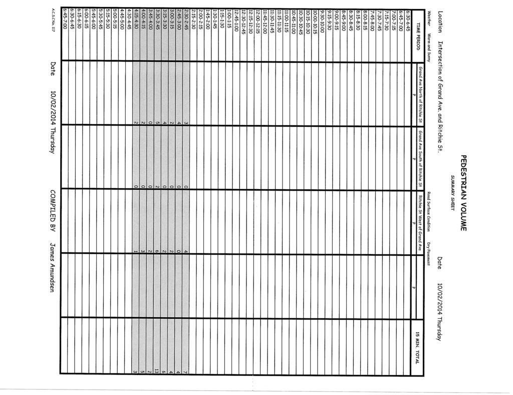
8 contract documents for review and approval prior to advertisement. The contract will be administered by the City of Pullman with oversight by WSDOT staff due to the project's federal funding and location on a state highway. 4. Data Collection, Stakeholder research, Documentation and Field Study Approach The data collection effort included accessing as much available related data as possible. However, it was necessary to supplement available data with additional vehicle and pedestrian counts and a site visit to verify and ensure the accuracy of the information for this specific crossing location. Because the pedestrian volumes counted were slightly less than the required minimum per the MUTCD warrant it is important to document other conditions that support a signalized pedestrian crossing at this location. Building the case for the installation of a hybrid beacon at this location required the collection of qualitative and quantitative data including traffic counts, census data, interviews and documentation from stakeholders. Traffic and Pedestrian Counts The City conducted counts at the intersection of N. Grand Avenue and Ritchie Street after WSU was in session in the fall of The traffic volume data is used in the warrant analysis table from Chapter 4F of the MUTCD. Initial pedestrian counts performed by the City for the TAP Grant application did not result in the minimum number of pedestrians during the peak hour required to meet the MUTCD warrant. The City conducted additional turning movement counts and pedestrian counts at the intersection in September These counts also did not generate the minimum number of pedestrians. The project team determined that the pedestrian peak hour was likely earlier in the day - closer to the time that area schools and WSU students are dismissed for the day. During this final supplemental count, a total of 17 pedestrians were counted on a Thursday during the peak hour; 2:45PM and 3:45 PM. Because of the variability in pedestrian volumes and the fact that without a marked crosswalk, there is likely to be significant latent demand at this location which would be realized with the HAWK signal, the City considered the count to meet the warrant requirements. City of Pullman N. Grand Ave at Ritchie Pedestrian Crossing Phase 1 - Technical Memorandum DN Traffic Consultants Final Draft - 9/21/2015 Page 7
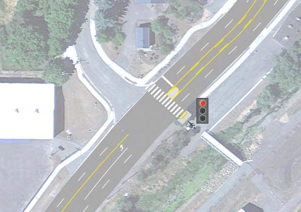
9 Multiple counts were conducted to ensure that typical conditions were being assessed. Turning movement counts were used in the queuing analysis. Census Data Census data supports the assertion there is a demand for a hybrid beacon crossing at this location. Specifically, census data on the number of workers commuting by walking and bicycling in small, medium and large cities between 2008 and 2012 were reviewed. Pullman is listed as a small city in both tables. The percentage of workers commuting by bicycle in the two Pullman census tracts was 2.4% and the number who reported commuting by foot (walking) was 23.5%. The percentage of people commuting by walking is very high compared to other cities of the same size. The data is supported by other census data about the percentage of workers who live and work in the same area, and therefore have short commutes and are likely to walk or bike to work. The percentage for Pullman was 87.4%. The census data demonstrates a latent demand for pedestrian activity at N. Grand Avenue and Ritchie Street. Many businesses can be accessed via the Grand Avenue Greenway trail. Schweitzer Engineering Laboratories is located at the north end of the trail and is a major employer in Pullman. Also, the southern end of the trail connects to Pullman Downtown Business District. WSU is located to the east. Providing a safe connection at Ritchie Street to the trail for those living west of Grand Avenue will increase opportunities for workers to commute to their place of work by bicycle or foot. This suggests that if a signalized crossing was constructed at N. Grand Avenue and Ritchie Street it would be used by City residents. Intersection geometry and other features The intersection of N. Grand Avenue and Ritchie Street is a three-way intersection. There is no westbound approach to the intersection; Ritchie Street terminates at N. Grand Avenue. Ritchie Street is a two-way collector street with one lane in each direction. N. Grand Avenue is a five lane roadway at this location and is 55 feet in width. The posted speed is 35 mph and the AADT is approximately 18,233. The distance to the nearest crossing to the north (Stadium Way) is 1795 feet. The distance to the closest crossing to the south (Whitman Street) is 1325 feet. City of Pullman N. Grand Ave at Ritchie Pedestrian Crossing Phase 1 - Technical Memorandum DN Traffic Consultants Final Draft - 9/21/2015 Page 8
10 Documentation and research from stakeholders including: The City of Pullman, Washington State University, Pullman Transit, Pullman School District, Pullman Police and WSDOT City Council Improvements to non-motorized facilities are mentioned as a goal of the City Council multiple times. The City Council references improvements to pedestrian and bicycle facilities in their 2012, 2013 and 2014, Council goals. Specifically in 2013, the Council referenced pedestrian improvements at the intersection of N. Grand Avenue and Ritchie Street. The Council's 2014 goals state: "Improve bicycle and pedestrian trails. Explore the implementation of appropriate recommendations in the WSU Bicycle and Pedestrian Plan. " City Public Works Department The Public Works Department has a 1996 Pedestrian and Bicycle Plan. Although the crossing at N. Grand Avenue and Ritchie Street is not specifically referenced, the crossing is part of a priority network that is identified in this document. The Public Works Department's opinion is that only a HAWK signal will provide a safe pedestrian crossing at this location due to the vehicle volumes and roadway width. The Department prepared an initial engineering study as part of the TAP grant application. The study looked at options for the location of the crossing and reviewed available traffic and pedestrian count data. A copy of the TAP grant is provided in the appendix. City of Pullman Police The City of Pullman Police Department expressed concern that driver compliance at non-signalized and flashing beacon controlled pedestrian crossings was a safety issue to the City and the Police Department. On several occasions, near misses between pedestrians and vehicles had been observed. Communication with Detective Chris Bishop revealed the Police Department is concerned about the safety of pedestrian crossings that are not signalized and do not provide vehicular control. Specifically, he referred to a lack of driver compliance at a crossing with a flashing beacon. He was supportive of the pedestrian hybrid beacon installation and noted the Police Department would support the installation by providing necessary enforcement to insure vehicular and pedestrian compliance. City of Pullman N. Grand Ave at Ritchie Pedestrian Crossing Phase 1 - Technical Memorandum DN Traffic Consultants Final Draft - 9/21/2015 Page 9
11 Pullman School District The School District verified students living within a one mile radius of the school walk to both Jefferson Elementary School and Pullman High School on the west side of North Grand Avenue. Few students cross at this location as students on the east side of Grand Avenue attend a different elementary school and students beyond one mile are given bus passes for their transportation to school. All high school students within the district are provided a bus pass and are not required to walk to school crossing N. Grand Avenue. Pullman Transit Pullman Transit provided feedback on the proposed crossing. The Operations Manager indicated they previously had a route that traveled on Ritchie Street but was discontinued due to low ridership. They said a stop controlled crossing may encourage a new bus route and/or stop be created if there are requests from the public. Their process to add new stops is directed by requests from the public. Pullman Transit annually prepares a report on ridership but it is used only to receive funding from WSDOT. Washington State University As stated previously, this project is supported by the University's 2013 Pedestrian and Bicycle Plan. This document identified infrastructure improvements necessary to support and safely accommodate bicycling and pedestrian activity on the Pullman campus and throughout the city of Pullman. Development of this plan involved various group discussions with key stakeholders, including input from the general public. Among other improvements, the plan identified the need for a pedestrian traffic signal on Grand Avenue at Ritchie Street, which is the location of a spur trail connecting Grand Avenue to the Grand Avenue Greenway multi-use trail. The plan identifies Ritchie Street as both a bicycle and pedestrian gap in the Grand Avenue Greenway trail. Gaps in the network discourage walking and biking because they limit access to key destinations and land uses. A pedestrian traffic signal at this location would safely connect the Grand Avenue Greenway trail to the southern half of Pullman s Military Hill, one of the four major hills making up Pullman. This connection would benefit not only students living off campus on Military Hill, whom reply heavily on bicycling, walking and public transit, but all citizens on Military Hill by providing safe access to the trail system for other beneficial uses. City of Pullman N. Grand Ave at Ritchie Pedestrian Crossing Phase 1 - Technical Memorandum DN Traffic Consultants Final Draft - 9/21/2015 Page 10
12 The plan also recommends the installation of wayfinding signs at the main trail to indicate to trail users what destinations can be reached by using the spur trail. These signs will likely improve the utilization of the signalized pedestrian crossing by better directing and informing the trail users of various destinations/opportunities. The WSU plan also identifies an area gap on the west side of Grand Avenue for bikeway and pedestrian facilities, due to a lack of defined bicycle/pedestrian routes. By filling in the gap, a logical connection point for this area will be realized. This will allow the area to be further defined and improved in the future for pedestrians and bicyclists, by creating a network using wayfinding signs that lead to the Grand Avenue crossing at Ritchie Street. The effects of this will also likely increase use of the pedestrian crossing. WSDOT WSDOT supports a crossing of N. Grand Avenue between the existing signalized crossings at Whitman Street and Stadium Way as a means to improve safety for all users. Because N. Grand Avenue is a state facility, (SR 27), WSDOT must be confident that the installation of a hybrid beacon will not adversely affect operations and safety of any modes. The City will address any operational issues that the signal may create after installation, in a timely manner. WSDOT also requires documentation to justify why the N. Grand Avenue/Ritchie Street intersection is the best possible location for a pedestrian hybrid beacon between Whitman Street and Stadium Way. Conclusions Both the qualitative and quantitative data that were collected as part of the Consultant's research demonstrated support for the pedestrian hybrid beacon crossing at N. Grand Avenue at Ritchie Street. The City's opinion is the MUTCD warrant will be realized when the HAWK signal is installed when one considers the day to day variations in traffic flow and the unserved latent pedestrian demand at this location. The City Council, Pullman Public Works Department, Pullman Police, WSU, Pullman Transit and the Pullman School District support the project either formally in their plans or informally when contacted about the project now that it has funding. In addition, the most recent census data for the City of Pullman proves there is higher than average use of non-motorized modes in travel to and from work. City of Pullman N. Grand Ave at Ritchie Pedestrian Crossing Phase 1 - Technical Memorandum DN Traffic Consultants Final Draft - 9/21/2015 Page 11
13 Experience with other non-signalized crossings in the City, combined with existing vehicular volumes, roadway width and posted speed on N. Grand Avenue; suggest that a pedestrian hybrid beacon is the appropriate approach to ensure pedestrian safety. 5. Analysis Results Collision History Crash history for the stretch of SR 27/N. Grand Avenue between Whitman Street and Stadium Way was requested from WSDOT for this project in WSDOT provided the last three years of crash data as requested. The purpose of reviewing crash data was to determine whether there was a history of crashes involving pedestrians in the vicinity of the proposed hybrid beacon crossing. Documented crash history of pedestrians and bicyclists involved crashes will further justify the need for a signalized crossing. There were two (2) pedestrian crashes between Whitman Street and Stadium Way in the three years starting in No deaths were caused as a result of the crashes, however the pedestrians were injured. In both instances, these pedestrians were crossing Grand Avenue in an area where no marked crosswalk exists. The long distance between crosswalks (0.6 miles) likely contributes to pedestrians crossing unsafely at random, un-marked locations along Grand Avenue. This further justifies the need for a safe crossing on Grand Avenue between Whitman Street and Stadium Way. Operational impacts, Queuing, and Collisions The nearest signalized intersections are 1795 feet and 1325 feet away from the intersection of N. Grand Avenue and Ritchie Street, therefore it is unlikely that any queue would cause a back-up that would impact operations at either of the adjacent intersections. However, an estimate of the maximum queue was determined to ensure the queue would not interfere with traffic operations on N. Grand Avenue. The methodology used to estimate queuing was the D/D/1 queuing theory. This methodology is one of the fundamental methods traditionally used in estimating queues at signalized intersections. The essential assumption with this theory is that the queue clears at the end of every cycle. This would be expected under HAWK signal operation. The estimation of the maximum queue is based on the arrival rate of vehicles multiplied by the total red time for the arriving vehicles. In the case of the hybrid beacon, the red time is the pedestrian crossing time. City of Pullman N. Grand Ave at Ritchie Pedestrian Crossing Phase 1 - Technical Memorandum DN Traffic Consultants Final Draft - 9/21/2015 Page 12
14 The pedestrian crossing time for this evaluation was based on Figure 4E-2 of the MUTCD. The pedestrian crossing time is comprised of the walk interval (a minimum of 7 seconds), the pedestrian clearance time (the time it takes for a pedestrian to clear the width of the crossing) and the buffer interval/all red. In order to accurately assess the worst case scenario for queuing, an assumption about the pedestrian crossing time and clearance time had to be made. For this assumption, the pedestrian speed was assumed to be 3 ft. /s. This is a conservative estimate taking into account an aging population. The vehicular arrival rate is based on the peak hour approach volumes. The PM peak hour approach volumes are 961 and 953 veh/hr. in the southbound and northbound directions respectively. The result is an arrival rate of 0.27 veh/s in both directions. The pedestrian clearance time is the amount of time it takes a pedestrian to clear the 55 foot width at 3 feet/s which equals 18.3 seconds. The total red time/pedestrian crossing time is 28.3 seconds (7 seconds seconds + 3 seconds). This results in a maximum queue length of 7.6 vehicles. At an average of 25 feet per vehicle, the maximum queue in feet is 191. As a result, it is not expected the queue from the HAWK operation will impact the signal to the north or south. If the signal was activated a total of 10 times during the peak hour, assuming groups of 2 or more pedestrians per crossing, the queue would never be longer than the maximum calculated above as it would always have time to dissipate between pedestrian calls. Gap Analysis At WSDOT s request, a gap analysis at the proposed crossing location was carried out to determine the number of available vehicle gaps across Grand Avenue. The location for the counting equipment was the north side of Ritchie Street across all four lanes of Grand Avenue, a width of 55 feet. This location represented the preferred location for the HAWK signal at the time the gap analysis was performed. The pedestrian crossing time was calculated to be 23 seconds using standard practice of 7 seconds plus the crossing distance divided by the average pedestrian speed of 3.5 ft/s. Gaps were counting from 2:30 pm to 6:00 pm on August 31 st, 2015 and September 2 nd, These dates were chosen to capture traffic during a time when schools including Washington State University were in session. City of Pullman N. Grand Ave at Ritchie Pedestrian Crossing Phase 1 - Technical Memorandum DN Traffic Consultants Final Draft - 9/21/2015 Page 13
15 The results of the gap analysis showed that there were 45 and 46 gaps of 23 seconds or greater during the vehicle peak period (5:00 pm to 6:00 pm) on Monday the 31 st and Wednesday the 2 nd respectively. Detailed output from the detection equipment is provided in the appendix. Conclusions There is evidence of a history of pedestrian related crashes on N. Grand Avenue between the two existing signalized crossings at Whitman Street and Stadium Way. This implies a need for a safe crossing along this stretch of Grand Avenue. The queuing analysis suggests that the crossing would not generate a queue long enough to interfere with operations at either of the two adjacent signalized intersections during the peak hour of pedestrian crossing traffic. The location of the stop bar and related signing (Do Not Block Intersection) in the four conceptual designs are intended to prevent the queue from blocking any part of the intersection of North Grand Avenue and Ritchie Street. The gap analysis shows there are more available gaps than the hourly pedestrian crossing volume (17) that was most recently counted at Grand Avenue and Ritchie Street. 6. Conceptual Design and Cost Estimate Summary of each conceptual design alternative The purpose of the conceptual design effort was to identify a preferred location for the pedestrian hybrid beacon. This design effort is not intended to be part of the PS&E effort as existing conditions such as utility conflicts and geotechnical conditions have not yet been assessed. The conceptual design effort revealed the proposed locations for the crossing, related sidewalks and ramps, signing, pavement markings and cabinet locations based on the information collected in the topographic survey. It is anticipated the City and WSDOT will agree on a preferred alternative from the set of four conceptual design options. Initially a total of three conceptual designs were to be developed. Upon further consideration, the City requested that an additional crossing on the north side of Ritchie be added for consideration. As a result, there are three crossing concepts north of Ritchie Street and one south of Ritchie Street. It was ideal to have the crossing close to City of Pullman N. Grand Ave at Ritchie Pedestrian Crossing Phase 1 - Technical Memorandum DN Traffic Consultants Final Draft - 9/21/2015 Page 14
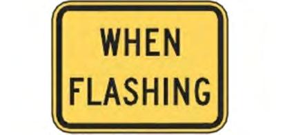
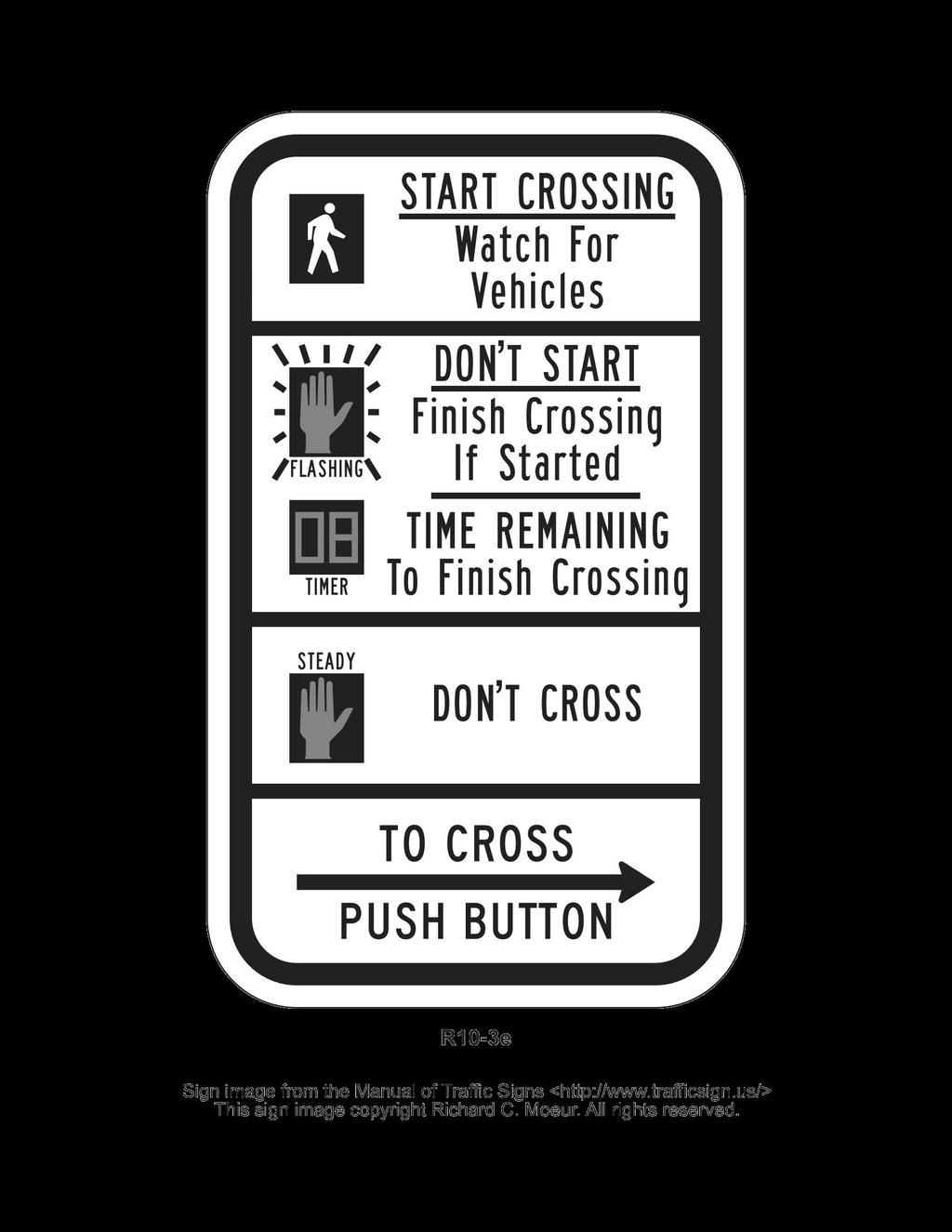
16 Ritchie Street because of the proximity to the regional trail on the east side of N. Grand Avenue. Initially MUTCD guidance stated the crossing should be at least 100 feet from the nearest intersecting street. The NCUTCD has since issued a decision that this need not be a mandatory requirement. WSDOT has stated that they agree with this decision and will allow crossings closer than 100 feet from intersecting streets. Design issues As noted there are no WSDOT design standards or standard plans for pedestrian hybrid beacons. The approach to the design is based on accepted approaches for both signalized intersections and crosswalks. The approach to the conceptual design for this project was to maximize pedestrian and vehicular safety. Compliance and use of familiar design elements was employed because pedestrian hybrid beacons are new to many users. The placement of the stop bar in each of the conceptual designs was based on MUTCD guidance for crosswalk stop bar placement. The distance of 40 feet is intended to provide additional sight distance of pedestrians on multi-lane facilities. This distance also provides the required visibility of signal heads for drivers. The stopping sight distance was calculated according to standard practice. The resulting stopping sight distance for the posted speed (35 mph) on N. Grand Avenue was acceptable in both the northbound and southbound directions. From AASHTO, the stopping sight distance requirements for a pedestrian crossing at a posted speed of 35 mph is 250 feet. At a conceptual level, it appears this stopping sight distance can be met with each of the four concepts. Confirmation will be made during the final design of the preferred concept. Signing in advance of the pedestrian hybrid beacon was applied based on MUTCD warning signs for crosswalks and signalized intersections. A conservative approach to signing was applied to all conceptual designs as pedestrian hybrid beacons are new to most drivers in the area and in the state. Additional signing directing vehicles where to stop was provided to minimize driver confusion. The goal of the signing is to provide advance warning of the pedestrian hybrid beacon in part because it is a new traffic control tool to most drivers. In addition, mid-block crossings are not as common. The displays for pedestrians mounted on the signal poles are provided to convey the meaning of all of the phases of the displays on the pedestrian signal head. All static signing is referenced in both the MUTCD and the WSDOT Sign Fabrication Manual. City of Pullman N. Grand Ave at Ritchie Pedestrian Crossing Phase 1 - Technical Memorandum DN Traffic Consultants Final Draft - 9/21/2015 Page 15
17 N. Grand Avenue Hybrid Beacon Crossing: Option 1 The first option is a crossing approximately 60 feet north of Ritchie street. The purpose of the first option was to provide some distance between the crossing and the intersection at Ritchie Street and the driveway on the east side of N. Grand Avenue. The separation, per original MUTCD guidance, provides visibility of pedestrians in the pedestrian hybrid crossing to vehicles turning out of Ritchie Street or the driveways on the east side of N. Grand Avenue just north of Ritchie Street. With this concept, sidewalk and pavement markings must be added to provide a connection back to the N. Grand Avenue Greenway Trail. Pedestrians must cross the driveway, on the laundromat site (on the east side of N. Grand Avenue across from Ritchie Street), in order to get access to the bridge and trail connection. All concepts have the same signing plans. No right of way is required on any of the conceptual designs, but it will be necessary to coordinate with the business and property owners on the east side of N. Grand Avenue to inform them there will be a marked walkway on the parking lot that must safely accommodate pedestrians. Note: The business owner may not be aware the property does not belong to the property owner but rather to the City. N. Grand Avenue Hybrid Beacon Crossing: Option 2 The second option is a crossing approximately 40 feet north of Ritchie street. This conceptual design is the same as the first option but the crossing is closer to Ritchie Street. By bringing it closer the hope is that it will be more convenient for pedestrians. N. Grand Avenue Hybrid Beacon Crossing: Option 3 The third option is a crossing immediately north of Ritchie street. This location would occur where a crosswalk would be traditionally located at a signalized intersection. This is the most convenient location for pedestrians as they do not have to walk north or south on N. Grand Avenue to reach the crossing, as it lines up directly with the Grand Avenue Greenway trail spur. Vehicles turning left out of Ritchie Street will be warned by a flashing beacon placed immediately in front of them on the east side of N. Grand Avenue when a pedestrian is in the crosswalk. The flashing beacon will be activated by the pedestrian call. The purpose of the flashing beacon is to warn vehicles turning left out of Ritchie that a pedestrian is in the crosswalk as they may not be expecting a pedestrian crossing since City of Pullman N. Grand Ave at Ritchie Pedestrian Crossing Phase 1 - Technical Memorandum DN Traffic Consultants Final Draft - 9/21/2015 Page 16
18 the intersection is not signalized. The location of this concept is superior because it provides a direct connection to the trail on the east side of N. Grand Avenue. Pedestrians do not have to cross the driveway in the private development of the east side of the road making it a safer option for all users. N. Grand Avenue Hybrid Beacon Crossing: Option 4 The fourth concept has a crossing approximately 100 feet south of Ritchie Street. This option is the only one located on the south side of the intersection. Originally it was thought that it would be safer on the south side as right turning vehicles out of Ritchie Street are more likely to look to the right and see a pedestrian in the crosswalk. This location presents the most inconvenience to users as it is located the furthest from the Grand Avenue Greenway trail spur. Conceptual Design Cost estimates The conceptual design estimates are to be considered very preliminary based on the level of design. The following items are included: Mobilization (the same for each concept) Traffic control (the same for each concept) Design contingency of 10% Construction contingency of 20% PS&E/Final Design fees Construction engineering The cost of options 1 and 2 are $200,000 and $198,000 respectively. The cost of the third option is $208,000. The costs are higher due to the flashing beacon. Finally, the cost of the fourth option is $258,000. The fourth option is much higher due to the extensive sidewalk construction required. Comparison of conceptual designs The evaluation of the conceptual design options is based on the following criteria which are stated in order of importance: pedestrian safety, convenience for pedestrians, costs and vehicular compliance. The option that best meets these criteria is option 3: the crossing immediately north of Ritchie Street. This option provides the most convenient location for pedestrians and provides a direct connection to the N. Grand Avenue Greenway Trail on the east side. Pedestrians do not have to cross a driveway in this option. This option complies with the NCUTCD decision, allowing a pedestrian hybrid beacon to be installed at or City of Pullman N. Grand Ave at Ritchie Pedestrian Crossing Phase 1 - Technical Memorandum DN Traffic Consultants Final Draft - 9/21/2015 Page 17
19 immediately adjacent to an intersection with a side road. The side road is controlled by a stop sign. Similar configurations have been successfully implemented in other areas such as: Tucson, AZ: E. Broadway Blvd and Norris Ave. Tucson, AZ: E. Broadway Blvd and S. Niven Ave. Tucson, AZ: E. Broadway Blvd and N. Cherry Ave. The flashing beacon was added to further provide a positive warning to drivers and therefore enhance safety for pedestrians in the crossing. The costs for this option are slightly higher than the lowest cost option but are significantly lower than the highest cost option, number 4. Driver compliance is expected to be similar in each concept as this is a new traffic control device to most drivers. The detailed cost estimates for each option, as well as the conceptual designs, can be found in the appendix. 7. Next steps Selection and approval of preferred alternative conceptual design Following the selection and approval of the preferred alternative by the City of Pullman and WSDOT, the next stage of the project will proceed. This will include the preparation of contract documents, environmental documentation, applying for a Traffic Signal permit, a public information effort, and additional survey and geotechnical investigations, if necessary. The contract documents will be prepared according to WSDOT plans preparation guidelines. WSDOT will be provided 90% design contract documents for review and approval prior to advertisement. City of Pullman N. Grand Ave at Ritchie Pedestrian Crossing Phase 1 - Technical Memorandum DN Traffic Consultants Final Draft - 9/21/2015 Page 18
20 Wayfinding Assessment Because the crossing of N. Grand Avenue at Ritchie Street provides a connection to the regional trail system, it is recommended that a way finding assessment be carried out during the PS&E effort. Considerations should be made to guide non-motorized users from facilities on the west side of N. Grand Avenue to the trail connection on the east side. This could include distance markers to destinations such as WSU, area schools and recreational facilities. To quote directly from the WSU Bicycle and Pedestrian Plan, if you build a facility, people will use it; however, if you build the facility and tell people about it, they will embrace it. City of Pullman N. Grand Ave at Ritchie Pedestrian Crossing Phase 1 - Technical Memorandum DN Traffic Consultants Final Draft - 9/21/2015 Page 19
21 References 1. FHWA Safety Program, "Pedestrian Hybrid Beacon Guide - Recommendations and Case Study", USDOT, FHWA [Access 9/29/14]. 2. FHWA, Safety Effectiveness of the HAWK Pedestrian Crossing Treatment, Publication No: FHWA-HRT , July FHWA, Manual on Uniform Traffic Control Devices, USDOT, City of Pullman City Council, Council Goals 2012, 2013 and U.S. Department of Commerce, Economics and Statistics Administration, US Census Bureau, Commuter Adjusted Daytime Population, U.S. Department of Commerce, Economics and Statistics Administration, US Census Bureau, Percentage of Workers Who Commuted by Bicycle in Small Cities to 2012, U.S. Department of Commerce, Economics and Statistics Administration, US Census Bureau, Percentage of Workers Who Commuted by Walking in Small Cities to 2012, Swartz, Diahn L., "Implementing Hybrid (HAWK) Pedestrian Signals", 2010 [Access 9/30/14]. City of Pullman N. Grand Ave at Ritchie Pedestrian Crossing Phase 1 - Technical Memorandum DN Traffic Consultants Final Draft - 9/21/2015 Page 20
22 Appendix
23 LEGEND CONTROLLER CABINET POWER SERVICE CABINET SIGNAL POLE GROUND MOUNTED SIGN (SEE SHEET 5 FOR SIGN LEGEND) LIGHTING (MOUNTED ON SIGNAL POLE) SIGNAL HEAD PEDESTRIAN SIGNAL HEAD (MOUNTED ON SIGNAL POLE) MAST ARM SIGN PEDESTRIAN PUSH BUTTON NEW SIDEWALK ADA PED RAMP STOP BAR STRIPED WALKWAY CONCEPT - NOT FOR CONSTRUCTION N. GRAND AT RITCHIE PEDESTRIAN CROSSING PROJECT CONCEPTUAL DESIGN OPTION 1 Plot XX PLAN REF. NO. XX SHEET 1 OF 5 SHEETS
24 LEGEND CONTROLLER CABINET POWER SERVICE CABINET SIGNAL POLE GROUND MOUNTED SIGN (SEE SHEET 5 FOR SIGN LEGEND) LIGHTING (MOUNTED ON SIGNAL POLE) SIGNAL HEAD PEDESTRIAN SIGNAL HEAD (MOUNTED ON SIGNAL POLE) MAST ARM SIGN PEDESTRIAN PUSH BUTTON NEW SIDEWALK ADA PED RAMP STOP BAR STRIPED WALKWAY CONCEPT - NOT FOR CONSTRUCTION N. GRAND AT RITCHIE PEDESTRIAN CROSSING PROJECT CONCEPTUAL DESIGN OPTION 2 Plot XX PLAN REF. NO. XX SHEET 2 OF 5 SHEETS
25 LEGEND CONTROLLER CABINET POWER SERVICE CABINET SIGNAL POLE GROUND MOUNTED SIGN (SEE SHEET 5 FOR SIGN LEGEND) LIGHTING (MOUNTED ON SIGNAL POLE) SIGNAL HEAD PEDESTRIAN SIGNAL HEAD (MOUNTED ON SIGNAL POLE) MAST ARM SIGN PEDESTRIAN PUSH BUTTON NEW SIDEWALK ADA PED RAMP STOP BAR STRIPED WALKWAY CONCEPT - NOT FOR CONSTRUCTION N. GRAND AT RITCHIE PEDESTRIAN CROSSING PROJECT CONCEPTUAL DESIGN OPTION 3 Plot XX PLAN REF. NO. XX SHEET 3 OF 5 SHEETS
 MAST ARM SIGN PEDESTRIAN PUSH BUTTON NEW SIDEWALK ADA PED RAMP STOP BAR STRIPED WALKWAY CONCEPT - NOT FOR CONSTRUCTION Plot XX N.")
26 LEGEND CONTROLLER CABINET POWER SERVICE CABINET SIGNAL POLE GROUND MOUNTED SIGN (SEE SHEET 5 FOR SIGN LEGEND) LIGHTING (MOUNTED ON SIGNAL POLE) SIGNAL HEAD PEDESTRIAN SIGNAL HEAD (MOUNTED ON SIGNAL POLE) MAST ARM SIGN PEDESTRIAN PUSH BUTTON NEW SIDEWALK ADA PED RAMP STOP BAR STRIPED WALKWAY CONCEPT - NOT FOR CONSTRUCTION Plot XX N. GRAND AT RITCHIE PEDESTRIAN CROSSING PROJECT CONCEPTUAL DESIGN OPTION 4 PLAN REF. NO. XX SHEET 4 OF 5 SHEETS


27 CONCEPT - NOT FOR CONSTRUCTION Plot XX N. GRAND AT RITCHIE PEDESTRIAN CROSSING PROJECT SIGN LEGEND PLAN REF. NO. XX SHEET 5 OF 5 SHEETS
28 Conceptual Design Level Cost Estimate: Option 1 Item Bid Item Unit Quantity Unit Price Total 1 Moblization LS 1 $ 5, $ 5, Traffic Control LS 1 $ 5, $ 5, Remove Curb LF 20 $ $ Concrete Curb Ramp Type A EA 2 $ 2, $ 4, Tactile warning surface EA 2 $ $ 1, Concrete sidewalk SY 24 $ $ 1, Plastic stop bar LF 46 $ 3.75 $ Plastic crosswalk LF 56 $ 3.50 $ Pedestrian hybrid Beacon* LS 1 $ 85, $ 85, Lighting LS 1 $ 7, $ 7, Striping/pavement markings LF 500 $ 1.15 $ Permanent signing LS 1 $ 4, $ 4, Subtotal $ 115, Design Contingency (10%) $ 11, Construction Contingency (20%) $ 23, TOTAL $ 149, Design Engineering/PS&E $ 35, Construction Engineering (10% of TOTAL) $ 14, GRAND TOTAL $ 199, *Complete system, installed
29 Conceptual Design Level Cost Estimate: Option 2 Item Bid Item Unit Quantity Unit Price Total 1 Moblization LS 1 $ 5, $ 5, Traffic Control LS 1 $ 5, $ 5, Remove Curb LF 20 $ $ Concrete Curb Ramp Type A EA 2 $ 2, $ 4, Tactile warning surface EA 2 $ $ 1, Concrete sidewalk SY 12 $ $ Plastic stop bar LF 46 $ 3.75 $ Plastic crosswalk LF 56 $ 3.50 $ Pedestrian hybrid Beacon* LS 1 $ 85, $ 85, Lighting LS 1 $ 7, $ 7, Striping/pavement markings LF 500 $ 1.15 $ Permanent signing LS 1 $ 4, $ 4, Subtotal $ 114, Design Contingency (10%) $ 11, Construction Contingency (20%) $ 22, TOTAL $ 148, Design Engineering/PS&E (20%) $ 35, Construction Engineering (10% of TOTAL) $ 14, GRAND TOTAL $ 198, *Complete system, installed
30 Conceptual Design Level Cost Estimate: Option 3 Item Bid Item Unit Quantity Unit Price Total 1 Moblization LS 1 $ 5, $ 5, Traffic Control LS 1 $ 5, $ 5, Remove Curb LF 20 $ $ Concrete Curb Ramp Type A EA 2 $ 2, $ 4, Tactile warning surface EA 2 $ $ 1, Concrete sidewalk SY 10 $ $ Plastic stop bar LF 46 $ 3.75 $ Plastic crosswalk LF 56 $ 3.50 $ Pedestrian Hybrid Beacon* LS 1 $ 85, $ 85, Flashing beacon* LS 1 $ 7, $ 7, Lighting LS 1 $ 7, $ 7, Striping/pavement markings LF 250 $ 1.15 $ Permanent signing LS 1 $ 4, $ 4, Subtotal $ 120, Design Contingency (10%) $ 12, Construction Contingency (20%) $ 24, TOTAL $ 156, Design Engineering/PS&E $ 35, Construction Engineering (10% of TOTAL) $ 15, GRAND TOTAL $ 207, *Complete system, installed
31 Conceptual Design Level Cost Estimate: Option 4 Item Bid Item Unit Quantity Unit Price Total 1 Moblization LS 1 $ 5, $ 5, Traffic Control LS 1 $ 5, $ 5, Remove Curb LF 20 $ $ Concrete Curb Ramp Type A EA 2 $ 2, $ 4, Tactile warning surface EA 2 $ $ 1, Concrete sidewalk SY 540 $ $ 43, Plastic stop bar LF 46 $ 3.75 $ Plastic crosswalk LF 56 $ 3.50 $ Pedestrian hybrid Beacon* LS 1 $ 85, $ 85, Lighting LS 1 $ 7, $ 7, Striping/pavement markings LF 250 $ 1.15 $ Permanent signing LS 1 $ 4, $ 4, Subtotal $ 156, Design Contingency (10%) $ 15, Construction Contingency (20%) $ 31, TOTAL $ 203, Design Engineering/PS&E $ 35, Construction Engineering (10% of TOTAL) $ 20, GRAND TOTAL $ 258, *Complete system, installed
32
33
34
35
36
37


38 Date: Dwn: Chk: City of Pullman Engineering Division N.Grand at Ritchie Pedestrian Crossing

39 City of Pullman Public Works Division M E M O R A N D U M TO: FROM: RE: Kevin Gardes, P.E., Director of Public Works Clayton Forsmann, P.E., Deputy Director of Public Works Grand Ave. at Ritchie St. Crossing Engineering Study DATE: October 30, 2013 Below is an Engineering Study regarding the implementation of a pedestrian crossing on Grand Avenue at Ritchie Street. This location has been chosen because it is a central junction which will provide connection for pedestrian and bike traffic between Military and College Hills along Grand Avenue. The Grand Avenue sidewalk system and the Grand Avenue Greenway trail/path system intersect at this location, providing a logical place for a new pedestrian crossing. Engineering Study Summary Conditions: Grand Ritchie Street No crossing currently at this location 5 lanes ~55 feet overall width Speed limit 35mph 18,683 vehicles per day (3 Day ADT 2009) Distance to nearest crossings o 1,325 feet south to Grand Ave/Whitman St o 1,795 feet north to Grand Ave/Stadium Way Preliminary pedestrian counts (this is not a marked crossing counts will not represent post marking counts) o 10/16/13 4 pedestrians in one hour o 10/23/13 4 pedestrians in one hour
40 MUTCD chapter 4C Warrant 4, Pedestrian Volume Warrant 4 requires a minimum of 107 pedestrians per hour (pph) for any four hour period, or 133 pph for the peak hour. Even though the pedestrian counts we have do not accurately represent pedestrian counts once a marked crossing is installed, it is unrealistic to believe the counts will increase from 4 to 133 pph. Therefore, warrant 4 is not met. MUTCD chapter 4F Pedestrian Hybrid Beacons A pedestrian hybrid beacon may be considered for installation to facilitate pedestrian crossings at a location that does not meet traffic signal warrants. CORRECT (Warrant 4 not met) Figure 4F 1 requires 20 pph for a pedestrian hybrid beacon. Our preliminary counts (4 pph) do not accurately represent pedestrian counts once a marked crossing is installed. It seems realistic to believe that counts will increase to 20 pph once a marked crossing is installed, considering the distance to the nearest crossings. Engineering study for pedestrian hybrid beacons should consider major street volumes, speeds, widths, and gaps in conjunction with pedestrian volumes, walking speeds, and delay. Other options available which must be considered include flashing beacons (chapter 4L) and in roadway lights (chapter 4N). Engineering Study Results Based on our engineering study, the City of Pullman has selected the pedestrian hybrid beacon crossing for the proposed crossing of Grand Avenue at Ritchie Street. Below please find the considerations that led to this decision. High Traffic Volumes Based on 2009 traffic counts, the 3 day ADT for Grand Avenue at Ritchie Street is 18,683 vehicles. The peak hour average is 1,692 vehicles per hour. The posted speed limit is 35 mph. These high traffic volumes create long wait times for pedestrians to find sufficient gaps to cross all 5 lanes of traffic. Preliminary pedestrian counts showed an average of 25 seconds wait time for pedestrians to find a sufficient gap to cross. In addition, many of those pedestrians actually had to run across in order to make it in time. Because of the high traffic volumes, the speed of the vehicles, and the width of Grand Avenue, there is a higher need for pedestrian protection. The pedestrian hybrid beacon controls traffic by stopping vehicles, thus providing the necessary pedestrian protection. Warning beacons were considered, but based on our experience with these crossings in other parts of the city, they are not always effective, as some vehicles fail to respond to them. In roadway lights were also considered, but they also do not stop traffic, but warn them instead. The pedestrian hybrid beacon offers the highest pedestrian / vehicular interaction and provides the protection needed for pedestrians to cross safely with a high confidence level. A 2006 study indicated that the pedestrian hybrid beacon crossing
41 showed an average of 97% motorists compliance. A refuge island may also be considered to maximize pedestrian protection. Proximity to Nearest Crossings & Lack of Accurate Pedestrian Volume Counts The proposed crossing of Grand Avenue at Ritchie Street, lies 1,325 feet south at the intersection of Whitman Street, and 1,795 feet north at the intersection of Stadium Way. Both of these crossings are at intersections controlled by traffic signals with pedestrian signals as well. Without this crossing, a pedestrian would travel 3,120 feet before reaching another crossing. The need for an additional crossing is evident. A pedestrian hybrid beacon would provide a comparable level of service to the pedestrian as the pedestrian controls at Whitman Street and Stadium Way. Our preliminary pedestrian counts were only 4 pph at Ritchie Street. This does not meet the criteria (20 pph) in MUTCD for the pedestrian hybrid beacon. However, this is not an accurate representation of the number of pedestrians this crossing will see once installed. That is because there is not a crossing at this location currently, so pedestrians generally don t cross here. In addition, it is likely that some of the pedestrians currently crossing at Whitman Street and Stadium Way, would be distributed to the new crossing at Ritchie Street. This will also increase the pedestrian counts at Ritchie Street. Therefore, it is reasonable to consider that once implemented, this crossing will see the minimum 20 pph. The pedestrian hybrid beacon would also work for future traffic and pedestrian volume increases in years to come.

42

43


44
45
46

47
48
49 Study Area... 1 Campus Master Planning... 2 Vision, Goals and Objectives...3 Plan and Policy Review... 6 Public Involvement...7 Stakeholder Interviews... 8 Benefits of Healthy Design... 9 Engineering: Existing Bikeway Network Engineering: Existing Pedestrian Network Encouragement: Existing End of Trip Facilities...14 Evaluation: Collision and Safety History Encouragement: Existing Multimodal Connections Online Survey Results Engineering: Bikeway Network Assessment Engineering: Pedestrian Network Assessment... 19
50 Evaluation: Collision and Safety Assessment Introduction Engineering Education Encouragement Enforcement Evaluation Introduction Project Prioritization Phasing Plan Implementation Costs Implementation Strategies... 99
51
52 As Grand Avenue Greenway continues north parallel to Grand Avenue, a spur trail connects trail users directly to Grand Avenue opposite NW Ritchie Street. The crossing of Grand Avenue for bicyclists and pedestrians at this location is difficult for the following reasons: 5 lane cross-section of Grand Avenue. The length of this crossing makes it difficult for non-motorized users to cross safely. No marked crossing. There are no indicators to bicyclists and pedestrians where they could cross, and no indicator to motorists that people might wish to cross at this location. Stripe a crosswalk on the north side of the Ritchie/Grand intersection. Install a small median on the north side of the intersection to provide visual cues to motorists that there is a crossing at this location and to provide a more protected refuge for pedestrians while making the crossing. Install a pedestrian traffic signal for the bicycle and pedestrian crossing. Pedestrians will use a pushbutton to activate the signal; bicyclists should stand on the bike detection marking or use the pushbutton to actuate the signal. Install wayfinding signs at the main trail to indicate to trail users what destinations can be reached by using the spur trail (Ritchie Street Neighborhood Greenway, Cougar Country Drive- In, etc).


53
54 The current alignment of the Grand Avenue Greenway intersects Stadium Way about 150 feet east of the intersection at Grand Avenue. Because of the proximity to the Grand Avenue intersection, all trail users are expected to use the existing sidewalks to travel to the signalized intersection and cross Stadium Way. Traveling out of direction and along a sidewalk is less attractive to many trail users, leading to the risky behavior of crossing the 5 lanes of traffic where the Greenway trail intersects Stadium Way. North of Stadium Way, install a new section of Greenway heading west just north of the Jack in the Box parking lot. Implementation will require the cooperation of the property owner. The new section of greenway will require a prefabricated bridge to be installed over the creek. Widen the existing sidewalk on the east side of Grand to the fullest extent possible to create a new section of greenway. Install a new section of greenway by removing one eastbound travel lane. Install wayfinding signs. With the removal of a short section of the eastbound travel lane, the eastbound lane on NW Stadium Way on the approach to Grand Avenue will need to be converted to a right-turn only. Remove the old path and replant with grass or landscaping.
55
56
57
58

59
60
61
62
City of Albert Lea Policy and Procedure Manual 4.10 ALBERT LEA CROSSWALK POLICY
 4.10 ALBERT LEA CROSSWALK POLICY PURPOSE: Pedestrian crosswalks are an integral part of our transportation infrastructure. To be effective and promote safety, marked crosswalks must be installed after
Appendix A: Crosswalk Policy
 Appendix A: Crosswalk Policy Appendix A: Crosswalk Policy Introduction This citywide Crosswalk Policy is aimed at improving pedestrian safety and enhancing pedestrian mobility by providing a framework
Agenda. Overview PRINCE GEORGE S PLAZA METRO AREA PEDESTRIAN PLAN
 PRINCE GEORGE S PLAZA METRO AREA PEDESTRIAN PLAN May 28, 2008 Agenda Welcome and introductions Project overview and issue identification Planning context and strengths Design challenges and initial recommendations
IMPROVING PEDESTRIAN SAFETY AT UNCONTROLLED CROSSINGS. Guidelines for Marked Crosswalks
 IMPROVING PEDESTRIAN SAFETY AT UNCONTROLLED CROSSINGS Presented by Nazir Lalani P.E. Traffex Engineers Inc. N_lalani@hotmail.com Guidelines for Marked Crosswalks Source: FHWA, Safety Effects of Marked
Citywide Sidewalk and Crosswalk Programs
 Citywide Sidewalk and Crosswalk Programs Council Meeting October 20, 2015 Presented by Rita Hu and Jamal Mahmoud Program Goals Implement the City s comprehensive plan. Provide pedestrian with safe walking
APPENDIX A: Complete Streets Checklist DRAFT NOVEMBER 2016
 APPENDIX A: Complete Streets Checklist DRAFT NOVEMBER 2016 Complete Streets Checklist MetroPlan Orlando s Complete Streets Checklist is an internal planning tool for staff to further implementation of
CITY OF KASSON TRANSPORTATION ALTERNATIVES KASSON SAFE ROUTES TO SCHOOL
 ve ha 8t G B A Mantorville Ave N 240th Ave 16th St NE 11th Ave NE K-M HIGH SCHOOL SUNRISE TRAIL TO MANTORVILLE MNTH 57 SUNSET TRAIL TO MANTORVILLE NE PARK 16TH ST NE TRAIL K-M ELEMENTARY SCHOOL K-M MIDDLE
DEPARTMENT OF ENVIRONMENTAL SERVICES. North Harrison Street (Lee Highway to Little Falls Road) Comparative Analysis. Prepared for:
 Comparative Analysis. Prepared for:") DEPARTMENT OF ENVIRONMENTAL SERVICES North Harrison Street (Lee Highway to Little Falls Road) Comparative Analysis Prepared for: Arlington County Department of Environmental Services 2100 Clarendon Boulevard,
DEPARTMENT OF ENVIRONMENTAL SERVICES North Harrison Street (Lee Highway to Little Falls Road) Comparative Analysis Prepared for: Arlington County Department of Environmental Services 2100 Clarendon Boulevard,
MEMORANDUM. Date: 9/13/2016. Citywide Crosswalk Policy
 MEMORANDUM Date: 9/13/2016 Re: Citywide Crosswalk Policy Foreword Through the s Circulation Element and Complete Streets Policy, it is the City s goal to promote walking trips and provide safe facilities
PEDESTRIAN SAFETY IMPROVEMENT EVALUATION GUIDELINE FOR UNCONTROLLED CROSSINGS
 PEDESTRIAN SAFETY IMPROVEMENT EVALUATION GUIDELINE FOR UNCONTROLLED CROSSINGS Traffic Safety Engineering Division Updated: April 2018 EXECUTIVE SUMMARY NDOT Traffic Safety Engineering Division developed
5. RUNNINGWAY GUIDELINES
 5. RUNNINGWAY GUIDELINES These guidelines should be considered collectively when making runningway decisions. A runningway is the linear component of the transit system that forms the right-of-way reserved
Active Transportation Facility Glossary
 Active Transportation Facility Glossary This document defines different active transportation facilities and suggests appropriate corridor types. Click on a facility type to jump to its definition. Bike
NJDOT Complete Streets Checklist
 Background The New Jersey Department of Transportation s Complete Streets Policy promotes a comprehensive, integrated, connected multi-modal network by providing connections to bicycling and walking trip
Pedestrian Project List and Prioritization
 To: Kyle Wagenschutz, City of Memphis CC: From: Anne Conlon and John Cock, Alta Planning + Design Date: December, 2014 Re: Project List Development (Task 3.1-3.2) and Project List Prioritization (Task
Bicycle Facilities Planning
 Bicycle Facilities Planning Overview Types of Cyclists Purpose for Riding Types of Facilities Bike Lanes Bicycle Boulevards Cycle Tracks Intersections Signals Signing and Marking Discussion Types of Bicyclists
REGIONAL BICYCLE AND PEDESTRIAN DESIGN GUIDELINES
 REGIONAL BICYCLE AND PEDESTRIAN DESIGN GUIDELINES November 16, 2011 Deb Humphreys North Central Texas Council of Governments Bicycle and Pedestrian Advisory Committee Snapshot of the Guide 1. Introduction
Broadway Street Pedestrian Safety Study Cass Street to 700 Feet North of Randall Avenue
 Broadway Street Pedestrian Safety Study Cass Street to 700 Feet North of Randall Avenue Prepared for: City of De Pere, Wisconsin Prepared by: June, 2017 Broadway Street Pedestrian Safety Study Cass Street
Hidden Oaks Elementary School
 Hidden Oaks Elementary School SCHOOL ROUTE PLAN For HIDDEN OAKS ELEMENTARY SCHOOL LOCATION 13 ORANGE COUNTY Prepared for: ORANGE COUNTY SCHOOL ASSESSMENT PROGRAM ORANGE COUNTY PUBLIC WORKS Traffic Engineering
CITY OF SARATOGA SPRINGS PEDESTRIAN CROSSING TOOLBOX
 CITY OF SARATOGA SPRINGS PEDESTRIAN CROSSING TOOLBOX This toolbox is to be used to guide pedestrian crossing improvements within the City of Saratoga Springs. Details for each crossing type are provided.
Chapter 2: Standards for Access, Non-Motorized, and Transit
 Standards for Access, Non-Motorized, and Transit Chapter 2: Standards for Access, Non-Motorized, and Transit The Washtenaw County Access Management Plan was developed based on the analysis of existing
This page intentionally left blank.
 This page intentionally left blank. COMMUNITY Coweta Community Overview Coweta Coweta, a residential community located in Wagoner County, is a suburb of Tulsa situated southeast of the metropolitan area
PEDESTRIAN ACCOMMODATIONS DPS 201 AT INTERCHANGES
 PEDESTRIAN ACCOMMODATIONS DPS 201 AT INTERCHANGES UNDERSTANDING THE ISSUES Intersections of freeway ramp terminals at crossroads are the most critical components of an interchange Challenge: balance mobility
Appendix T CCMP TRAIL TRAFFIC & TRANSPORTATION DESIGN STANDARD
 Appendix T CCMP 3.3.4 TRAIL TRAFFIC & TRANSPORTATION DESIGN STANDARD 3.3.4 Trail Traffic and Transportation Design Multi-use trails have certain design standards, which vary depending on the agency that
Broad Street Bicycle Boulevard Design Guidelines
 Broad Street Bicycle Boulevard Design Guidelines Building from the strategies introduced in the 2013 Bicycle Transportation Plan and community input received thus far, City Transportation Staff have identified
UNCONTROLLED PEDESTRIAN CROSSING GUIDELINES
 City and County of Denver UNCONTROLLED PEDESTRIAN CROSSING GUIDELINES Prepared for: Prepared by: Adopted September 2016 This page is intentionally left blank. Contents for Denver Uncontrolled Pedestrian
Watertown Complete Streets Prioritization Plan. Public Meeting #1 December 14, 2017
 Watertown Complete Streets Prioritization Plan Public Meeting #1 December 14, 2017 Goals for Public Meeting Overview of MassDOT Complete Streets Funding Program Educate the community on Complete Streets
Designing for Pedestrian Safety in Washington, DC
 Designing for Pedestrian Safety in Washington, DC February 25, 2014 George Branyan Pedestrian Program Coordinator District Department of Transportation DC Journey to work mode split: 2012 Means of Transportation
FEDERAL HIGHWAY ADMINISTRATION APPLICATION
 FEDERAL HIGHWAY ADMINISTRATION APPLICATION REQUEST FOR PERMISSION TO EXPERIMENT WITH A BICYCLE BOX INTERSECTION TREATMENT Submitted by: City of Columbus Department of Public Service Date: June 26, 2009
MEMORANDUM. Discussion of the planned crosswalk improvement on Mount Vernon Road near Stratham Drive
 MEMORANDUM To: From: Mayor and City Council Michael Smith, Public Works Director Date: August 24, 2015 Subject: Discussion of the Mount Vernon Road Crosswalk Improvement ITEM DESCRIPTION Discussion of
Pedestrian Crossing Guidelines 2016
 Pedestrian Crossing Guidelines 2016 Engineering Services 1.0 Introduction and Background The City of Kingston s first Pedestrian Crossing Guidelines were approved by Council in 2008 in order to provide
MEMORANDUM. Charlotte Fleetwood, Transportation Planner
 MEMORANDUM Date: Updated August 22, 2017 To: Organization: Charlotte Fleetwood, Transportation Planner Boston Transportation Department From: Jason DeGray, P.E., PTOE, Regional Director of Engineering
PRINCE GEORGE S PLAZA METRO AREA PEDESTRIAN PLAN
 PRINCE GEORGE S PLAZA METRO AREA PEDESTRIAN PLAN May 28, 2008 Agenda Welcome and introductions Project overview and issue identification Planning context and strengths Design challenges and initial recommendations
METHODOLOGY. Signalized Intersection Average Control Delay (sec/veh)
") Chapter 5 Traffic Analysis 5.1 SUMMARY US /West 6 th Street assumes a unique role in the Lawrence Douglas County transportation system. This principal arterial street currently conveys commuter traffic
Chapter 5 Traffic Analysis 5.1 SUMMARY US /West 6 th Street assumes a unique role in the Lawrence Douglas County transportation system. This principal arterial street currently conveys commuter traffic
Dr. M.L. King, Jr. Street North Complete Streets Resurfacing Opportunities HOUSING, LAND USE, AND TRANSPORTATION COMMITTEE MARCH 22, 2018
 Dr. M.L. King, Jr. Street North Complete Streets Resurfacing Opportunities HOUSING, LAND USE, AND TRANSPORTATION COMMITTEE MARCH 22, 2018 What s Happening The City plans to mill and resurface Dr. M.L.
Document 2 - City of Ottawa Pedestrian Crossover (PXO) Program
 Program") 40 Document 2 - City of Ottawa Pedestrian Crossover (PXO) Program OVERVIEW The City of Ottawa Pedestrian Crossover (PXO) Program provides the basis for PXO implementation in Ottawa. The program s processes
40 Document 2 - City of Ottawa Pedestrian Crossover (PXO) Program OVERVIEW The City of Ottawa Pedestrian Crossover (PXO) Program provides the basis for PXO implementation in Ottawa. The program s processes
Caltrans Sloat Boulevard Pedestrian Safety Project Response to Community Questions, Comments & Concerns
 Caltrans Sloat Boulevard Pedestrian Safety Project Response to Community Questions, Comments & Concerns Revised: May 10, 2016 The California Department of Transportation (Caltrans) is planning various
Ottawa Beach Road Study
 Ottawa Beach Road Study Prepared For: Park Township September 30, 2014 Project No. G140303 OTTAWA BEACH ROAD STUDY PREPARED FOR: PARK TOWNSHIP SEPTEMBER 30, 2014 PROJECT NO. G140303 TABLE OF CONTENTS 1.0
The DC Pedestrian Master Plan
 The DC Pedestrian Master Plan September 28, 2010 George Branyan Pedestrian Program Coordinator District Department of Transportation Presentation Agenda Scope of the Plan Methodology Recommendations Implementation
Guidance. ATTACHMENT F: Draft Additional Pages for Bicycle Facility Design Toolkit Separated Bike Lanes: Two-Way to One-Way Transitions
 ATTACHMENT F: Draft Additional Pages for Bicycle Facility Design Toolkit Separated Bike Lanes: Two-Way to One-Way Transitions This treatment provides a transition from two-way separated bike lanes to one-way
Date: April 4, Project #: Re: A Street/Binford Street Traffic/Intersection Assessment
 To: Peter Cavanaugh General Electric From: David Bohn, PE Ryan White, PE Date: April 4, 217 Project #: 13421. Re: / Traffic/Intersection Assessment Consistent with the Cooperation Agreement between the
EUCLID AVENUE PARKING STUDY CITY OF SYRACUSE, ONONDAGA COUNTY, NEW YORK
 EUCLID AVENUE PARKING STUDY CITY OF SYRACUSE, ONONDAGA COUNTY, NEW YORK CITY OF SYRACUSE DEPARTMENT OF PUBLIC WORKS 1200 CANAL STREET EXTENSION SYRACUSE, NEW YORK 13210 DRAFT REPORT DATE: November 13,
Chapter VISION, MISSION, AND GOALS AND OBJECTIVES. Vision. Mission. Goals and Objectives CONNECTING COMMUNITIES ACROSS THE ST.
 VISION, MISSION, AND GOALS AND OBJECTIVES Chapter 3 The Plan s vision, mission, and goals and objectives were developed through a series of interactive exercises with the Citizens Advisory Committee (CAC)
Lake Whitney Elementary School
 Lake Whitney Elementary School SCHOOL ROUTE PLAN For LAKE WHITNEY ELEMENTARY SCHOOL LOCATION 18 ORANGE COUNTY Prepared for: ORANGE COUNTY SCHOOL ASSESSMENT PROGRAM ORANGE COUNTY PUBLIC WORKS Traffic Engineering
Fisher Ave and Snoqualmie Parkway Signal
 Fisher Ave and Snoqualmie Parkway Signal Topics How does the City assess roadway conditions? What is the City s standard? What has occurred at Snoqualmie Parkway and Fisher Ave.? What are we currently
Welcome! San Jose Avenue Open House August 25, 2015
 Welcome! San Jose Avenue Open House August 25, 2015 Vision Zero The City and County of San Francisco adopted Vision Zero San Francisco Vision Zero High Injury Network as a policy in 2014, committing an
Military Road Safety Improvements
 Military Road Safety Improvements 26 th Road North to 31 st Street North SUMMARY OF DATA REVIEW AND PRELIMINARY RECOMMENDATIONS Prepared for: Department of Environmental Services Traffic Engineering and
Arlington Public Schools Thomas Jefferson Site Evaluation Transportation Networks. Thomas Jefferson Working Group Meeting #6 November 10, 2014
 Arlington Public Schools Thomas Jefferson Site Evaluation Transportation Networks Thomas Jefferson Working Group Meeting #6 November 10, 2014 2 3 INTRODUCTION 4 Goal of our work: Identify and assess multi-modal
DOWNTOWN TUPELO MAIN STREET: ROAD DIET STUDY
 DOWNTOWN TUPELO MAIN STREET: ROAD DIET STUDY Since mid-2009, RPM Transportation Consultants (RPM) has worked with the Downtown Tupelo Main Street Association to evaluate traffic conditions and potential
Bicycle Boulevards and Neighborhood Greenways
 Bicycle Boulevards and Neighborhood Greenways Traffic Safety is Improving for Everyone 90 80 70 60 50 40 30 20 10 0 PORTLAND: TOTAL TRAFFIC FATALITIES 1986-2008 1986 1987 1988 1989 1990 1991 1992 1993
Appendix B Warrants, Standards, and Guidelines for Traffic Control Devices used at Senior Citizen and Disabled Person Crossings
 Appendix B Warrants, Standards, and Guidelines for Traffic Control Devices used at Senior Citizen and Disabled Person Crossings B.1 General Minnesota Statute 169.215 and Highway Traffic Regulation 169.222
FHWA Experimentation #4-298(E) Modified HAWK Signal and Bike Signal - Draft Report
 Modified HAWK Signal and Bike Signal - Draft Report") FHWA Experimentation #4-298(E) Modified HAWK Signal and Bike Signal - Draft Report August 2, 2010 Table of Contents Preface... 1 Problem Statement... 1 Study Objectives... 2 Data Collection Methods...
FHWA Experimentation #4-298(E) Modified HAWK Signal and Bike Signal - Draft Report August 2, 2010 Table of Contents Preface... 1 Problem Statement... 1 Study Objectives... 2 Data Collection Methods...
Fundamentals of Traffic Control Devices
 Fundamentals of Traffic Control Devices Traffic Engineering & Operations October 8, 2014 Raj Ponnaluri, Angela Wilhelm, and Christopher Lewis Agenda Agenda Signs Pavement Markings Signals Traffic Operations
Cycle Track Design Best Practices Cycle Track Sections
 Design Best Practices Sections It is along street segments where the separation and protection methods of cycle tracks offer more comfort than conventional bicycle lanes, and are more attractive to a wide
City of Novi Non-Motorized Master Plan 2011 Executive Summary
 City of Novi Non-Motorized Master Plan 2011 Executive Summary Prepared by: February 28, 2011 Why Plan? Encouraging healthy, active lifestyles through pathway and sidewalk connectivity has been a focus
Chapter 2. Bellingham Bicycle Master Plan Chapter 2: Policies and Actions
 Chapter 2 Bellingham Bicycle Master Plan Chapter 2: Policies and Actions Chapter 2: Policies and Actions The Bicycle Master Plan provides a road map for making bicycling in Bellingham a viable transportation
Draft North Industrial Area-Wide Traffic Plan
 Summary of North Industrial and Hudson Bay Industrial Recommended Improvements Table 1. Summary of s Item Location 1 2 3 4 5 6 7 8 9 10 11 12 Millar Ave north of 51st St Super 8 Motel back lane 400 Block
Approximately 360 trail users cross during a typical summer weekday and 420 cross during a typical summer
 5. PARKR ROAD AT MISSISSIPPI AVN CROSSIN xisting Conditions The High ine Canal trail crosses Parker Road near the Mississippi Avenue intersection (crossing location #3 on Figure 1). South of Parker, the
Addendum to SDDCTEA Pamphlet 55 17: Better Military Traffic Engineering Revision 1 Effective: 24 Aug Crosswalk Guidelines
 Addendum to SDDCTEA Pamphlet 55 17: Better Military Traffic Engineering Revision 1 Effective: 24 Aug 2017 Crosswalk Guidelines Warrants for Uncontrolled Crosswalk Locations Crosswalks at Midblock Locations
AGENDA ITEM G-2 Public Works
 AGENDA ITEM G-2 Public Works STAFF REPORT City Council Meeting Date: 12/6/2016 Staff Report Number: 16-214-CC Regular Business: Approve the Oak Grove University Crane Bike Improvement Concept Plan, authorize
Coquitlam Cross-town Bike Route Improving Bicycle Facilities in a Mature Suburban Environment
 Coquitlam Cross-town Bike Route Improving Bicycle Facilities in a Mature Suburban Environment Sarah Rocchi, Vice-President, Projects, Opus International Consultants (Main Presenter) Catherine Mohoruk,
FLORIDA DEPARTMENT OF TRANSPORTATION DISTRICT 7 DISTRICT WIDE BICYCLE/PEDESTRIAN ACCESS TO TRANSIT SAFETY ASSESSMENT AND IMPROVEMENT PLAN
 FLORIDA DEPARTMENT OF TRANSPORTATION DISTRICT 7 DISTRICT WIDE BICYCLE/PEDESTRIAN ACCESS TO TRANSIT SAFETY ASSESSMENT AND IMPROVEMENT PLAN TRANSIT SAFETY ASSESSMENT SR 55/US 19 AT 80 TH AVE N DRAFT JUNE
Chapter 5: Crossing the Street
 Chapter 5: Crossing the Street Whether walking or bicycling, a student s journey to school will more than likely require crossing one or more streets. Per the Safe Routes to School Guide, maintained by
Pedestrian Hybrid Beacon Guide Recommendations and Case Study. FHWA Safety Program.
 Pedestrian Hybrid Beacon Guide ecommendations and Case Study FHWA Safety Program http://safety.fhwa.dot.gov A pedestrian hybrid beacon (PHB) is a traffic control device similar to a European pedestrian
TOWN OF MORAGA MORAGA WAY AND CAMINO PABLO/CANYON ROAD IMPROVEMENTS Town Council Meeting March 13, 2019
 TOWN OF MORAGA MORAGA WAY AND CAMINO PABLO/CANYON ROAD IMPROVEMENTS Town Council Meeting March 13, 2019 1 Edric Kwan, Public Works Director Josh Peterman, Principal, Fehr and Peers Shawn Knapp, Senior
CROSSING GUARD PLACEMENT CONSIDERATIONS AND GAP ASSESSMENT
 CROSSING GUARD PLACEMENT CONSIDERATIONS AND GAP ASSESSMENT Many factors contribute to the need for a Crossing Guard. General federal guidance, provided by the FHWA MUTCD, states that adult crossing guards
July 5, Arthur R. Ware, Jr. Elementary School 2017 Safe Routes to School Walkabout Report
 July 5, 2017 Arthur R. Ware, Jr. Elementary School 2017 Safe Routes to School Walkabout Report 1 Walkabout Report Introduction On April 28, 2017, City, School, and SAWMPO staff met to conduct a Safe Routes
BETHEL ROAD AND SEDGWICK ROAD CORRIDOR STUDY
 DRAFT PLAN City Council Meeting August 14, 2017 STUDY AREA Sedgwick Corridor State Route 160, principal arterial with Class 3 access management designation, commuter and freight route, connection to SR
Omaha s Complete Streets Policy
 Omaha s Complete Streets Policy (Adopted August 2015) VISION To create great places and enhance our quality of life, the City of Omaha will provide safe, accessible streets for all users. Complete Streets
Corporate. Report COUNCIL DATE: May 25, 1998 NO: R1500 REGULAR COUNCIL. TO: Mayor & Council DATE: April 27, 1998
 R1500 : Traffic Safety at 25 Avenue and 128 Street Intersection Corporate NO: R1500 Report COUNCIL DATE: May 25, 1998 REGULAR COUNCIL TO: Mayor & Council DATE: April 27, 1998 FROM: General Manager, Engineering
TRANSPORTATION & MOBILITY VISIONING MEETING. August 23 24, 2017
 TRANSPORTATION & MOBILITY VISIONING MEETING August 23 24, 2017 Project Team 1999 South Lakefront Framework Plan In 1999, the Chicago Park District authorized framework plans for three historic parks: Jackson,
Pedestrians and Bicyclists. Bruce Friedman and Scott Wainwright FHWA MUTCD Team
 Impact of the New MUTCD on Pedestrians and Bicyclists Bruce Friedman and Scott Wainwright FHWA MUTCD Team Development of the 2009 MUTCD NPA published in the Federal Register on January 2, 2008 Received
Transportation Planning Division
 Transportation Planning Division Presentation Outline Study Tasks Recap of Previous Meetings Data Collected Focus Areas within Study Limits Design Principles Tool Box Recommended Concepts Schedule Moving
MEMORANDUM INTRODUCTION AREA DESCRIPTION. DATE: December 8, 2017
 7719 SOUTH MAIN STREET MIDVALE, UT 84047 P 801.307.3400 MEMORANDUM DATE: December 8, 2017 TO: FROM: SUBJECT: PROJECT NUMBER: 344-7517-003 PROJECT NAME: Keith Ludwig, P.E. Midvale City Lesley Burns, Midvale
C. Best Practice Pedestrian Treatment Toolbox
 C. Best Practice Pedestrian Toolbox The Best Practice Pedestrian Toolbox presents the recommended tools in striping, signalization, signage, geometry and other categories for improving both uncontrolled
RE: City of Portland Request to Experiment with HAWK/Bike signal
 October 4, 2005 Regina S. McElroy, Director Office of Transportation Operations HOTO Room 3401 400 7 th Street, S.W. Washington, D.C. 20590 RE: City of Portland Request to Experiment with HAWK/Bike signal
Pedestrian & Bicycle Safety Innovations & Applications
 Pedestrian & Bicycle Safety Innovations & Applications County Engineers Association of Maryland Spring, 2017 Conference May 25, 2017 George Branyan Pedestrian Program Coordinator District Department of
Bikeway action plan. Bicycle Friendly Community Workshop March 5, 2007 Rochester, MN
 Bikeway action plan Summary The was held on March 5, 2007 at the Rochester Mayo Civic Center. The workshop was hosted by Rochester-Olmsted County Planning Department in collaboration with the League of
TABLE OF CONTENTS. Executive Summary
 Executive Summary Background... ES-1 Pedestrian Network... ES-2 Bikeway Network... ES-2 Collision History... ES-2 Public Input... ES-4 Conclusions and Recommendations... ES-4 1. Introduction and Setting
TOWN OF PORTLAND, CONNECTICUT COMPLETE STREETS POLICY
 TOWN OF PORTLAND, CONNECTICUT COMPLETE STREETS POLICY I. VISION, GOALS & PRINCIPLES VISION To improve the streets of Portland making them safer and more accessible for all users including pedestrians,
Road Diets FDOT Process
 Florida Department of TRANSPORTATION Road Diets FDOT Process Humberto Castillero, PE, PTOE Roadway Design Office Purpose of Guide Develop a statewide lane elimination review process Balance state & local
Guidance for Installation of Pedestrian Crosswalks on Michigan State Trunkline Highways
 Guidance for Installation of Pedestrian Crosswalks on Michigan State Trunkline Highways Michigan Department of Transportation July 7, 2014 Engineering Manual Preamble This manual provides guidance to administrative,
Washington State University Bicycle and Pedestrian Plan Working Paper #7: Implementation Strategies
 nnn Washington State University Bicycle and Pedestrian Plan nnn TO: Bridgette Brady, CAPP, Director Parking and Transportation Services FROM: Alta Planning Design DATE: November 2013 Introduction As described
ROUNDABOUTS/TRAFFIC CIRCLES
 GENERAL 1. Description This standard identifies minimum requirements that shall be met for Roundabouts and Neighborhood Traffic Circles in the design and construction of elements for Arlington County Horizontal
School Zone Traffic Control Policy
 School Zone Traffic Control Policy I. GE ERAL CITY OF BILLINGS SCHOOL ZONE TRAFFIC CONTROL POLICY (Approved by Traffic Control Board 10/27/99) (Approved by Billings City Council on 6/25/01) This policy
Crosswalk Policy Revisions & Pedestrian & Bicycle Connection Plans. Presentation to Sanibel City Council July 16, 2013
 Crosswalk Policy Revisions & Pedestrian & Bicycle Connection Plans Presentation to Sanibel City Council July 16, 2013 Outline Crosswalk Policy Revisions Minimum Standards Goals and Objectives Pedestrian
Hennepin County Pedestrian Plan Public Comment Report
 Hennepin County Pedestrian Plan Public Comment Report On May 31, 2013, the draft Hennepin County Pedestrian Plan was released for a 45-day public comment period ending July 15, 2013. The county received
Meadow Woods Elementary School
 Drag and drop pic and stretch/crop to the limits of the blue rectangle (delete this text box) Meadow Woods Elementary School Drag and drop pic and stretch/crop to the limits of the blue rectangle (delete
Attachment No. 4 Approved by National Committee Council
 Attachment No. 4 Approved by National Committee Council The Signals Technical Committee distributed a technical committee recommendation to sponsors concerning pedestrian hybrid beacons following the January
Section 9A.07 Meaning of Standard, Guidance, Option, and Support
 2012 Edition Page 895 PART 9. TRAFFIC CONTROLS FOR BICYCLE FACILITIES CHAPTER 9A. GENERAL Section 9A.01 Requirements for Bicyclist Traffic Control Devices 01 General information and definitions concerning
Appendix C. Bicycle Route Signage
 Appendix C Bicycle Route Signage This page intentionally left blank. APPENDIX C - BICYCLE ROUTE AND WAYFINDING SIGNAGE Bicycle route signs are wayfinding signs that guide bicyclists along preferred, designated
C C C
 C-012-001 Thank you for your support for the creation of new public space and nonmotorized access between downtown and the waterfront through the Overlook Walk, the East-West Connections, and the Promenade.
Lee s Summit Road Improvement Study Public Open House June 7, 2007 Summary of Comment Card Responses
 Lee s Summit Road Improvement Study Public Open House June 7, 2007 Summary of Comment Card Responses Introduction At the Lee s Summit Road Improvement Study Public Open House held Thursday, June 7, 2007
TOWN OF CHAPEL HILL POLICY AND PROCEDURES FOR TRAFFIC CALMING MEASURES
 TOWN OF CHAPEL HILL POLICY AND PROCEDURES FOR TRAFFIC CALMING MEASURES (Adopted by the Town Council on June 30, 2004) (Revised December 6, 2010) (Revised February 8, 2016) POLICY AND PROCEDURES FOR TRAFFIC
About the Studio. Edward J. Bloustein School of Planning and Public Policy - Rutgers University
 About the Studio Edward J. Bloustein School of Planning and Public Policy - Rutgers University Purpose of studio: Help City of Bayonne apply for Safe Routes to School (SRTS) funding by producing a School
ORANGE COUNTY PUBLIC WORKS TRAFFIC INVESTIGATIONS
 ORANGE COUNTY PUBLIC WORKS TRAFFIC INVESTIGATIONS STAFF REPORT OF: January 6, 2019 SUPERVISORIAL DISTRICT: 5 SUBJECT: LOCATION: INVESTIGATOR: O Neill Drive at Roanoke Drive; Ladera Ranch; TB 922-E6 Clever
Defining Purpose and Need
 Advanced Design Flexibility Pilot Workshop Session 4 Jack Broz, PE, HR Green May 5-6, 2010 Defining Purpose and Need In your agency s project development process, when do design engineers typically get
Richmond-Adelaide Cycle Tracks
 Public Drop-In Event Richmond-Adelaide Cycle Tracks June 25, 2018 12:00 p.m. 3:00 p.m. 4:30 p.m. 7:30 p.m. Metro Hall, Rotunda 55 John Street 1 Purpose of Event In Scope Communicate an update about the
Town of Windsor Pedestrian Crossing Guidelines
 Town of Windsor Pedestrian Crossing Guidelines Prepared for: Town of Windsor Engineering Department 301 Walnut Street Windsor, Colorado 80550 For More Information, please contact: Engineering Department
General Design Factors
 Chapter 3: 3-1.0 Introduction General Design Factors Mn/DOT s goals include encouraging and accommodating safe bicycling. From a design perspective, these goals are achieved by first having an understanding
Who is Toole Design Group?
 2018 AASHTO Bike Guide Status Update NCHRP 15 60 Amalia Leighton Cody, PE, AICP & Kenneth Loen, PE Washington APWA October 4, 2018 Who is Toole Design Group? TDG is a full service engineering, planning