RCCG Jesus House. Preliminary Plan # TRAFFIC STUDY. Prepared for: RCCG Jesus House Montgomery County, Maryland
|
|
|
- Jonathan Fitzgerald
- 5 years ago
- Views:
Transcription
1 TRAFFIC STUDY Prepared for: Montgomery County, Maryland Prepared by: SSSTS Consulting (410) (410)
2 Table of Contents SECTION 1 - INTRODUCTION... 1 SECTION 2 - EXISTING CONDITIONS... 4 Public Road Network... 4 Study Area Definition... 6 Transit Facilities and Services... 6 Existing Traffic Counts..8 Pedestrian/Bicycle Statement Congestion Standard Existing Intersection Critical Lane Volumes SECTION 3 - FUTURE CONDITIONS WITHOUT THE PROJECT Overview Pipeline Developments Pipeline Development Peak Hour Traffic Future Traffic Forecasts without the Project Future Intersection CLV without Project SECTION 4 - FUTURE CONDITIONS WITH THE PROJECT Overview Site Access Concept Site Trip Generation Trip Distribution and Assignment Pass-By Trip Assignment Future Traffic Forecasts with the Project Future Intersection Critical Lane Volumes with the Project SECTION 5 - TRANSPORTATION POLICY AREA REVIEW (TPAR) Overview Mitigation SECTION 6 - INTERNAL CIRCULATION ANACCESS.26 SECTION 7 - CONCLUSION List of Figures Figure 1-1 Figure 2-1 Figure 2-2 Figure 2-3 Figure 3-1 Figure 3-2 Figure 3-3 Figure 4-1 Figure 4-2 Figure 4-3 Figure 4-4 Figure 4-5 Figure 6-1 Site Location Existing Lane Use and Traffic Control Trasnit Routes Existing Peak Hour Traffic Counts Location of Pipeline Developments Pipeline Developments Peak Hour Forecasts Future Peak Hour Forecasts without Development Site Plan Site Trip Distribution Site Trip Assignment Future Peak Hour Traffic Forecasts with Development Pass-by and Diverted Traffic Assignment Internal Circulation and Access
3 List of Tables Table 1-1 Proposed Development...1 Table 2-1 Intersection Capacity Analyses (CLV Method)-Existing Condtion...12 Table 3-1 Pipeline Project Trip Generation 14 Table 3-2 Intersection Capacity Analysis-Background Traffic without Project...16 Table 4-1 Site-Generated Trip Analysis 20 Table 4-2 Site Trip Distribution.20 Table 4-3 Intersection Capacity Analysis-Total Future Traffic.24 Table 6-1 SYNCHRO Result- Total Future Traffic Condition-Level of Service and Queuing...28 List of Appendices Appendix A Appendix B Appendix C Appendix D Scoping Documents Vehicle and Pedestrian Counts Existing Critical Lane Volume Worksheets SYNCHRO Output Files
4 INTRODUCTION This report presents the results of a Traffic Study for Jesus House s (the Applicant ) planned 1,600 seat house of worship, a 350 student K-12 th grade school and a multipurpose youth center located at New Hampshire Avenue in the Cloverly Policy Area of Montgomery County, Maryland. The Center is expected to be used during weekday evening hours after 7:00 PM and on weekends. Table 1-1 Proposed Development Land Use Size House of worship 1600 Seat K-12th grade school 350 Students Total area of the buildings 110,000 square feet 1. This Traffic Study was originally dated August 9, 2015 with three alternative analysis of three traffic operation scenarios for the weekday peak for the school traffic that include: A. A full median break on New Hampshire Avenue at the site entrance. This included a queuing analysis using SYNCHRO model. B. U-turns allowed at New Hampshire Avenue and Harding Lane. (No median break) C. U-turns at New Hampshire Avenue and Norbeck Road. (No median break and no U turns permitted at Harding Lane) The Maryland State Highway Administration (SHA) has informed the applicant that they will consider a median break at the site entrance as a T-Intersection only allowing left-turn in and out of the subject site. This revised traffic study includes SHA, Montgomery County Department of Transportation (MCDOT) and M-NCPPC Montgomery County Planning Department s (MCPD) comments and suggested changes. A formal response letter has been submitted to reviewing agencies comments. This study is conducted in accordance with the Maryland-National Capital Park and Planning Commission s (M-NCPPC) current Local Area Transportation Review and Transportation Policy Area Review (LATR/TPAR) Guidelines. The study parameters were established in consultation with M- NCPPC staff. An approved copy of the M-NCPPC scope of work forms is included in Appendix A. The following are the tasks that were performed to prepare this study: 2. Review proposed development plans, previous traffic studies conducted in the area, and other background materials. 3. A field reconnaissance of existing roadway and intersection geometrics, traffic controls, traffic signal phasing, and speed limits. 4. Conduct existing vehicular and pedestrian traffic counts at seven (7) off-site intersections and at the location where the future site access will be located. 5. Analysis of existing critical lane volumes (CLVs) at each of the seven (7) off-site intersections. 6. Forecast of background traffic volumes based on existing traffic counts and added generated trips from eleven (11) background developments (approved but un-built development in the area) that were given to us by M-NCPPC staff.
5 7. Conduct background development trip distribution and assignments based on M-NCPPC procedure in the LATR and TPAR Guidelines. 8. Calculate future background development CLVs at each of the seven (7) off-site intersections for the weekday AM and PM peak hours. 9. Calculate the site generated trips during weekday AM and PM peak hours based on current LATR and TPAR Guidelines trip rates and /or trip calculation equations. 10. Calculate the site-generated trip distributions and assignments based on M-NCPPC procedures. 11. Calculate future traffic forecasts with the Project based on future background traffic plus site traffic assignments. 12. Calculate future CLVs with the Project at each of the seven (7) off-site intersections and the site access intersection with New Hampshire Avenue based on future traffic forecasts with the Project, existing traffic controls, and existing intersection geometrics. 13. Analysis of a full median break ( T intersection only allowing left-turns in and out of the subject site) on New Hampshire Avenue at the site entrance. This includes a queuing analysis and Level of Service (LOS) and delay results using SYNCHRO model. 14. Prepare a pedestrian and bicycle statement in accordance with the current LATR and TPAR Guidelines. 15. Evaluate and discuss transit routes, services and bus stops at all study intersections. A map of transit routes in the study area is provided. 16. Conduct and prepare a Transportation Policy Area Review analysis. 17. Prepare a traffic circulation statement and map. Sources of data and background information for this analysis include the M-NCPPC s current LATR and TPAR Guidelines; M-NCPPC s Growing Smarter Subdivision Staging Policy Report; Institute of Transportation Engineers (ITE) Trip Generation Manual-9th Edition, traffic counts conducted by STS Consulting, the Montgomery County Department of Transportation (MCDOT), and the Maryland State Highway Administration (MSHA). The summary of the traffic study findings and conclusions are as follows: 1. Currently, all seven (7) studied intersections operate within the congestion standard of 1,475 CLV for the Cloverly Policy Area during the weekday AM and PM peak hours. 2. Sidewalks and other pedestrian amenities including crosswalks, pedestrian signal heads and ADA ramps are located at some of the intersections and missing at other locations partly due to the rural character of the area. Bus service is limited and bus stops are sparsely located on the major roads. 2
 study intersections will continue to operate within the congestion standard. 5.")
6 3. Eleven (11) pipeline developments will generate 167 weekday AM peak hour trips and 270 weekday PM peak hour trips, upon completion. 4. With the additional traffic that would be added to the road network by pipeline developments, all seven (7) study intersections will continue to operate within the congestion standard. 5. The proposed new uses (350 student school) will generate a net 177 weekday AM peak hour trips and 177 weekday PM peak hour trips. The house of worship and the multipurpose youth center do not generate weekday peak hour trips. Six percent pass-by trips and 29 percent diverted trips were deducted to reach the net trips. 6. With the additional weekday peak hour traffic that would be added to the road network by the Project, all seven (7) study intersections will continue to operate within the congestion standard. 7. The Project passes the new TPAR test for highway capacity but fails due to inadequate transit services. The applicant should pay 25% of the impact tax to mitigate the inadequacy of transit services to pass the TPAR test. 8. Sidewalk/crosswalk and bicycle facilities (or missing) on segments of the road network and at a number of locations approaching the intersections. The list of facilities where these facilities are provided or links missing is discussed under the Pedestrian/Bicycle Statement. 9. Internal circulation and access would operate safely and efficiently with or without the median break on New Hampshire Avenue. Figure 1-1 Site Location SITE 3
7 SECTION 2 - EXISTING CONDITIONS Public Road Network Definitions of classes of roadways are as follows: Freeways Provide for movement of vehicles at high speed over significant distances. Access is limited to gradeseparated interchanges. Major Highways Provide less speed and mobility, but more access at intersections. Arterial Roads Connect major highways and provide more access points while moving traffic at lower speeds. Typically, more than half of the traffic on an arterial is through traffic. Commercial Business District Streets Are restricted to commercial areas, provide on-street parking, more pedestrian space, and more access points to stores and offices. Primary Residential Streets May carry some through traffic but their main purpose is to provide access for 200 or more households and to connect to arterial roads. Secondary or Tertiary Residential Streets Provide direct access to homes and allow for the possibility of traffic management measures to discourage through traffic movements and speeding. (These are not listed in master plans.) Existing Road Network Regional access to the Property is provided by the Intercounty Connector (ICCMD 200), New Hampshire Avenue (MD 650), Norbeck Road (MD 28) and Spencerville Road (MD 198). Direct access to the Property is provided from New Hampshire Avenue (MD 650). Existing intersection lane use and traffic control at key intersections in the site vicinity are shown in Figure 2-1. The ICC (MD 200) is a limited access highway linking I-370 to US 1 in Prince George s County. It is a six-lane toll road with bikeways provided along most sections of the road. There is an interchange at MD 650 providing regional access to the site. New Hampshire Avenue (MD 650) within the study area is a six-lane, median-divided, major highway providing both regional and local access to the site. MD 650 connects Washington, D.C. and the upper east side of Montgomery County. Sidewalks and crosswalks are located on the road near the site. Additional discussion of pedestrian and bicycle facilities at all intersections are provided in Section 2 of this traffic study. 4
8 Figure 2-1 Existing Lane Use and Traffic Control 5
9 Norbeck Road (MD 28) is a two-lane major highway from west of MD 650 to just east of Norwood Road and it then becomes a two-lane median-divided road to just west of Layhill Road (MD 182), providing regional access to the site. Spencerville Road (MD198) is two-lane major highway providing regional access to the site from points east including Howard and Prince George s Counties. Briggs Chaney Road is an arterial road connecting New Hampshire Avenue just south of the site to points east, providing regional and mostly local access to the site. Norwood Road is an arterial road connecting New Hampshire Avenue south of the site to points west, providing regional and mostly local access to the site. Ednor Road is an arterial road connecting points east and west of New Hampshire Avenue to the north of the site, providing regional and mostly local access to the site. Study Area Definition According to the current LATR and TPAR Guidelines, the study area is determined based on the number of trips that will be generated by the total development. Based on the current LATR and TPAR Guidelines rates/equations, the proposed K-12 private school will generate a total of 273 weekday AM peak hour trips. All students arriving at the school in the morning are expected to remain in school until 5 or 6 PM. Therefore, we assumed the same number of 273 generated trips for the weekday PM peak hour. M-NCPPC s LATR and TPAR Guidelines specify that the study area shall include a minimum of two (2) signalized intersections in each direction from the site driveways for sites that generate between 250 and 749 weekday peak hour trips. Access is proposed via New Hampshire Avenue. The following study intersections were specified by M-NCPPC staff: 1. New Hampshire Avenue (MD 650) and Norbeck Road (MD 28) 2. New Hampshire Avenue (MD 650) and Ednor Road 3. New Hampshire Avenue (MD 650) and Briggs Chaney Road 4. New Hampshire Avenue (MD 650) and Norwood Road 5. Briggs Chaney Road and Good Hope Road 6. Spencerville Road ( MD 198) and Peach Orchard Road 7. Norbeck Road (MD 28) and Norwood Road Transit Facilities and Services Metrobus Bus Service. Metrobus service provided by the Washington Metropolitan Area Transit Authority (WMATA) operates along New Hampshire Avenue. (Metrobus linez2 operates only during the peak periods.) Ride-On Bus Service. Ride-On Route 39 operates on Bonifant Road, Good Hope Road and Briggs Chaney Road near the site during the peak hours with 30 minute headways. Figure 2-2 Shows Transit Routes. 6

10 Figure 2-2 Transit Routs 7
11 Existing Traffic Counts Overview. Existing vehicular and pedestrian traffic counts were conducted by STS Consulting at the seven (7) off-site study intersections on Thursday, April 30, The traffic counts at the planned site access on New Hampshire Avenue were taken on June 4, 2015, during the AM and PM peak hours to calculate the CLV for the site s intersection with New Hampshire Avenue. These counts were conducted during a non-holiday week when Montgomery County public schools were in session from 6:30 to 9:30 AM, and from 4:00 to 7:00 PM, in accordance with the LATR and TPAR Guidelines. The existing vehicular traffic counts are presented in Appendix B and summarized in Figure 2-3. New Hampshire Avenue carries 1,520 AM peak hour trips and 1,399 PM peak hour trips, south of the site and 1,109 AM and 1,448 PM peak hour trips north of the site. During the AM peak hour, 66 percent travel southbound and 33 percent travel northbound. During the PM peak hour, 35 percent travel southbound and 65 percent travel northbound. A total of 40 pedestrians and one bicyclist were observed at all seven off-site intersections during the weekday AM and PM peak periods. Additional information is provided in the next section under Pedestrian and Bicycle Statement. 8
12 Figure 2-3 Existing Traffic Volume 9
13 Pedestrian/Bicycle Statement The pedestrian/bicycle statement discusses the safe and efficient pedestrian and bicycle access and circulation to and within the site as well as other off-site intersections evaluated for this traffic study. The site is located in the suburban area of Cloverly where population density is low and, due to land use characteristics of the area, minimal pedestrian and bicycle activities are taking place. Most locations have good sidewalks and limited bicycle facilities. Hiker/Bikers Lanes. Some areas have Hiker/Biker lanes which is defined as a minimum of 8-foot wide separate shared use path for bicyclists and pedestrians use. The following is a summary of existing pedestrian and bicycle facilities: 1. New Hampshire Avenue (MD 650) and Spencerville Road (MD 198) On the west side and south of the intersection, there is a 5-foot wide sidewalk terminating 200 feet south of the intersection. There are no sidewalk or bicycle facilities along the road to a point near the planned site access. There is a 5 sidewalk along the site frontage that is in a good shape and extends south for more than a mile. There are wide shoulders along this segment of New Hampshire Avenue. The applicant plans to provide lead-in sidewalks connecting to the facilities along the road. On the east side, south of the intersection, there is a 6-foot wide sidewalk in good condition for about 300 and then a 3-foot wide sidewalk connects to it extending south about half a mile. There are bus stops near the intersection on the east and west side of New Hampshire Avenue. To the north of the intersection, a 5-foot wide sidewalk extends about 330 on the east side and a 10 wide hiker biker lane is provided on the west side extending north to Ednor Road. A hiker biker lane extends to Norwood Road on the west side of MD 198 and a short segment of sidewalk exists on the south side of MD 198. On the east side of the intersection, north of MD 198, there are no sidewalk or bicycle facilities. On the south side, a sidewalk extends for a short distance. Currently there exists handicap ramps and crosswalks on the north, east and west of the intersection but not on New Hampshire Avenue (MD-650) on the south side of the intersection. There is no pedestrian activated signal at the intersection of New Hampshire Road (MD-650) and Norbeck/Spencerville Road (MD-198) at the following locations: a. Pedestrian crossing Norbeck Road on the west side of the intersection. b. Pedestrian crossing New Hampshire Road on the south side of the intersection. 2. New Hampshire Avenue (MD 650) and Ednor Road There is a 10 hiker/ biker lane on the west side of New Hampshire Avenue extending south. No other sidewalk or bicycle facilities are in place. The intersection has no activated pedestrian signals. There are crosswalks on the north and west sides of the intersection. There are existing handicapped ramps on the northwest, northeast and southwest sides of the intersection. 10
14 3. New Hampshire Avenue (MD 650) and Briggs Chaney Road Sidewalks (5-foot wide) exist along New Hampshire Avenue north of the intersection. There are missing links on the south side of the intersection. There are 5-foot wide sidewalks on the north side of Briggs Chaney Road extending east. There are crosswalks on the east and north sides of the intersection with handicapped ramps and pedestrian-activated signals for the directions that the crosswalks exist. There are bus stops on the northwest corner of the intersection for the Metrobus Z2 route. 4. New Hampshire Avenue (MD 650) and Norwood Road Sidewalks (5-foot wide) are located along MD 650 north of the intersection. Sidewalks also exist along the west side of MD 650 to the north and south of the intersection. There are crosswalks located on the south and west side of the intersection with pedestrian- activated signals and handicapped ramps. However, the ramp on the southwest corner of the intersection does not connect with the corresponding crosswalk. There are Metrobus stops on southwest and southeast corners of the intersection. 5. Briggs Chaney Road and Good Hope Road There are no sidewalks along any approaches but there are pedestrian-activated signals and crosswalks located on all sides. There is a handicapped ramp on the southwest corner of the intersection. There are Ride-On bus stops on the north and south sides of Briggs Chaney Road east of the intersection. 6. Spencerville Road (MD 198) and Peach Orchard Road There are no pedestrian, bicycle, pedestrian activated signals or handicapped ramps at or near the intersection. As we understand it, this intersection is being considered for improvements by SHA and the appropriate safety features would be part of the new design for the intersection. 7. Norbeck Road (MD 28) Norwood Road There is a 10-foot wide hiker/ biker lane on the north side of MD 28 extending east to MD 650 and to the west extending to Layhill Road (MD 182). A pedestrian walkway extends west on the south side of MD 28 for a short segment. Also, short sidewalks exist on Norwood Road extending south of the intersection. There are crosswalks on the west and north sides with pedestrian-activated signals. The handicapped ramp on the southeast corner of the intersection is offset from the crosswalks. 8. Site Access A short section of sidewalk along New Hampshire Avenue (MD 650) site entrance is located adjacent to the edge of the pavement. There will be acceleration/deceleration lanes at the site entrance with the sidewalk and bike lanes included in the cross section according to the SHA design guidelines. Congestion Standard The Project is located within the Cloverly Policy Area of Montgomery County. The congestion standard in this area is 1,450 CLV according to the LATR and TPAR Guidelines. The seven (7) studied intersections are located within the Cloverly Policy Area. 11
15 Existing Intersection Critical Lane Volumes Existing weekday peak hour critical lane volumes (CLV) were calculated at the seven (7) signalized intersections within the study area based on the existing lane use and traffic control shown in Figure 2-1. The existing vehicular traffic volumes are shown in Figure 2-4. M-NCPPC s CLV intersection capacity analysis procedures were used to determine the level of congestion at each studied intersection and the results are presented in Appendix C and summarized in Table 2-1. Table 2-1 indicates that each of the studied intersections currently operate within the congestion standard during the weekday AM and PM peak hours. Table 2-1 Intersection Capacity Analyses-Existing Condition (CLV Method) Intersection Existing Traffic AM PM 1. MD 650/MD 198/MD MD 650/Ednor Road MD 650/Briggs Chaney Road MD 650/Norwood Road Briggs Chaney Road/ Good Hope Road MD 198/Peach Orchard Road MD 28/ Norwood Road SECTION 3 - FUTURE TRAFFIC CONDITIONS WITHOUT THE PROJECT Overview This section presents analyses of future traffic conditions in the study area without the proposed site development for the 350 student K-12 private school. Pipeline Developments M-NCPPC staff identified 11 developments within the study area to be included as pipeline or background development in the scoping document (Appendix A). The developments include the following: 1. St. Constantine & Helen Greek ( ) West of Norwood Road and straddles Norbeck Road. Northeast and southeast corner of Norwood Road and Norbeck Road intersection. 35,930 square feet church (600 seats). 2. Bryants Nursery Road ( ) South of Norbeck Road and 1,500 feet east of Norwood Road/Norbeck Road intersection. 2 single family detached homes. 3. Bryants Nursery Road ( ) South of Norbeck Road and 1,800 feet east of Norwood Road/Norbeck Road intersection. 2 single family detached homes. 4. Hill Farm ( ) North of Norwood and 300 feet east of Crimson Spine Court 1 single family detached home. 5. Quershi ( ) North of Norwood and just to the east of Hill Farm ( ) noted above in #4) 3 single family detached homes. 12
16 6. Cloverly Farm Market ( ) West of New Hampshire (MD 650) and 200 feet north of Briggs Chaney Road behind the existing shopping center 56,000 square feet religious use. 7. Anselmo ( )) North of Briggs Chaney Road and approximately 0.4 miles to the east of the Briggs Chaney Road/New Hampshire Avenue intersection (MD 650) 32 single family detached homes and 5 single family attached homes. 8. Bernhard Acres ( ) Southeast corner of New Hampshire Avenue (MD 650) and Spencerville Road (MD 198) 5 single family detached homes. 9. Jacot Property ( ) South of Spencerville Road (MD 198) and 100 feet to the west of Oak Hill Road 1 single family detached home. 10. Spencerville Knolls ( ) North of Spencerville Road (MD 198) and 300 feet west of Thompson Road 4,800 square foot expansion of landscaping business. 11. PMG Silver Spring () Northeast corner of MD 198 and MD 650 Approved by the Planning Board on September 3, ,770 square foot convenience store with one drive through carwash and 10 gasoline pumps. 13
17 The pipeline development locations are listed in Table 3-1 and shown in Figure 3-1. Table 3-1 Pipeline Project Trip Generation Development Name Land Use AM PM In Out Total In Out Total 1. St. Constantine Church (New Trip)* 35,930 Square Ft.* Bryant Nursery Road 2 SF Res. Units Bryant Nursery Road 2 SF Res. Units Hill Farm 1 SF Res. Unit Quershi 3 SF res. Units Angelmo 32 Townhouses Cloverly Farm Church 56,000 Square Ft Angelmo 5 SF Res. Units Bernhard Acres 5 SF Res. Units Jacot Property 1 SF Res. Unit Spencervill Knolls Nursery 4,800 Square Feet PMG Silver Spring Conv. Store 1,770 Square Feet/10 Pump/Car Wash TOTAL
18 Figure 3-1 Location of Pipeline Development 15
19 Pipeline Development Weekday Peak Hour Traffic The number of weekday peak hour trips that will be generated by the 11 pipeline developments located within the study area were estimated based on standard M-NCPPC trip generation rates or the ITE trip rates/equations (8th Edition) as well as from an approved traffic study for one of the developments. As shown in Table 3-1, it is estimated that these projects will generate a total of 167 (83 in and 84 out) new weekday AM peak hour trips, and 270 (136 in and 134 out) new weekday PM peak hour trips, upon completion. Future Traffic Forecasts without the Project The weekday peak hour trips generated by the pipeline developments shown in Table 3-1 were assigned to the road network using the Trip Distribution and Traffic Assignment methodology for Super District 6 (White Oak, Fairland and Cloverly Policy Areas) published in the LATR and TPAR Guidelines. The combined peak hour traffic forecasts for all 11 developments are shown in Figure 3-2. The combined background traffic was added to existing weekday peak hour traffic at each intersection (Figure 3-2) to determine the future weekday peak hour traffic forecasts without the proposed development of the site as shown in Figure 3-3. Future Intersection Critical Lane Volumes without the Project Future weekday peak hour critical lane volumes without the Project were calculated at the seven (7) studied intersections based on the existing lane use and traffic control shown in Figure 2-1. The future weekday peak hour forecasts without the Project and the CLV intersection capacity analysis procedures, in accordance with M-NCPPC LATR guidelines, are shown in Figure 3-3. The results are presented in Appendix C and summarized in Table 3-2. Table 3-2 indicates that each of the seven (7) intersections would continue to operate within the congestion standard during both the weekday AM and PM peak hours. Table 3-2 Intersection Capacity Analysis-Background Traffic Without Project Intersection Background Traffic AM PM 1. MD 650/MD 198/MD MD 650/Ednor Road MD 650/Briggs Chaney Road MD 650/Norwood Road Briggs Chaney Road/ Good Hope Road MD 198/Peach Orchard Road MD 28/ Norwood Road
20 Figure 3-2 Pipeline Development Peak Hour Forecast 17
21 Figure 3-3 Future Peak Hour Forecast without Project 18
 a single access to the Project is proposed on MD 650.")
22 SECTION 4 - FUTURE CONDITIONS WITH THE PROJECT Overview This section presents analyses of total future weekday peak hour traffic conditions in the study area with the Project. Site Access /Median Break Concept As shown in Figure 4-1, (Site Plan) a single access to the Project is proposed on MD 650. The median on MD 650 currently prohibits the site access to operate as a full movement entrance. The original traffic study presented three scenarios as to how the site access may operate in the future: 1. There will be a median break to allow a full movement access. 2. The median will remain in place and the traffic generated to the site from the south will make a U turn at Harding Lane to reach its destination. 3. The median will remain in place and a NO U TURN sign will be installed at Harding Lane to prevent site traffic from making a U turn at Harding Lane. Therefore, the site generated traffic will be required to travel north to the intersection of MD 650 and MD 198 and make a U turn to reach its destination at the site. Figure 4-1 Site Plan Access Location STS Consulting presented a traffic analysis of possible median break along New Hampshire Avenue (in the initial traffic study) for a full movement access to the site. Maryland State Highway Administration has reviewed the results of the traffic operation and safety of a median break and has concluded that a T- 19
23 Intersection median break to provide a left in and left out only to and from the site access is justified and has the merit to pursue. Therefore, this revised traffic study presents the result of the traffic operation with the T-Intersection median break access to the site. The detailed analysis and result of the traffic operation with a median break is presented in Section 6-Interanl Circulation and Access. Site Trip Generation The site trip generation was calculated based on the LATR/TPAR Guidelines trip generation rate for a K- 12 private school. However, based on LATR/TPAR Guidelines, we suggested and MNCPPC staff approved a 6% pass-by trip and a 29% diverted trip reduction. The following table shows the site generated trips. (Table 4-1) Table 4-1 Site Trip Generation Land Use AM PM In Out Total In Out Total 350 K-12 Private School % Pass By Trips % Diverted Trips Total Trip Reduction Net New Trips As shown in Table 4-1 above, the proposed school would generate 273 (161 in and 112 out) total weekday AM peak hour trips and 273 (112 in and 161 out) total weekday PM peak hour trips. The Project will add 177 net new trips to the road network during the weekday AM and PM peak hours. Site Trip Distribution and Assignment The distribution of weekday peak hour trips generated by the Project was determined based on the Trip Distribution and Traffic Assignment Guidelines published in the LATR and TPAR Guidelines. The directions of approach for the Project are as follows: Table 4-2 Site Trip Distribution To/ From Via % Assigned North New Hampshire Avenue 2% South New Hampshire Avenue 75% East Briggs Chaney and MD % West MD 28 11% Total 100% The future site-generated weekday peak hour trips were distributed and assigned to the public road network according to the directional distribution described above and shown in Figure 4-2. The result of site traffic forecasts assignments are shown in Figure
24 Figure 4-2 Site Trip Distribution 21
25 Figure 4-3 Site Trip Assignment 22
26 Pass-By and Diverted Trip Assignment Based on discussion with MNCPPC staff and according to the approved scope of work, we have estimated 6% pass-by trips and 29% diverted trips. The assigned pass-by and diverted trips are shown in Figure 4-5. These trips exist on the network independent of the proposed project but stop at the site while traveling on the road network to some other destination. The distribution of these trips is determined based on the same distribution as site-generated trips. Future Traffic Forecasts with the Project The proposed future site traffic and background traffic were combined with existing traffic to yield the total future traffic shown in Figure 4-4. Future Intersection Critical Lane Volumes with the Project Future weekday peak hour CLVs with the Project were calculated at the studied intersections and at the site access point with the different scenarios based on the future median break, or U turns at Harding Lane or MD 198 and New Hampshire Avenue and are shown in Figure 4-4. As shown in Table 4-3, all studied intersections would continue to operate within the congestion standard during the weekday AM and PM peak hours with the Project. Table 4-3 Intersection Capacity Analyses-Total Future Traffic Condition Intersection Existing Traffic Background Traffic Total Future Traffic AM PM AM PM AM PM 1. MD 650/MD 198/MD MD 650/Ednor Road MD 650/Briggs Chaney Road MD 650/Norwood Road Briggs Chaney Road/ Good Hope Road MD 198/Peach Orchard Road MD 28/ Norwood Road
27 Figure 4-4 Future Peak Hour Traffic Forecast with Development 24
28 Figure 4-5 Pass-by and Diverted Trips 25
29 SECTION 5 - TRANSPORTATION POLICY AREA REVIEW (TPAR) Overview The site is located within the Cloverly Policy Area. This area has adequate roadway capacity but inadequate transit services. Mitigation The applicant should make a 25% Impact Tax payment as a mitigation measure to pass the test for inadequate transit services. Upon the additional impact tax, this application passes the TPAR test section of the transportation APFO. SECTION 6 INTERNAL CIRCULATION AND ACCESS The Jesus House is planned for a 1,600 seat house of worship mostly active on Sundays, a 350 student K- 12th grade School and a multipurpose youth center. The multipurpose youth center is expected to be used on weekends and after weekday evening peak hours. Two (2) Sunday services are planned with about 30 minutes intervals in between each service to avoid traffic exiting and entering the site to coincide. The access is designed to have one lane in and two lanes out to allow for the traffic exiting the site to separate between those traveling north and south with a T-Intersection design median break on New Hampshire Avenue. STS Consulting used SYNCHRO model to simulate the traffic operation at the site access intersection with New Hampshire Avenue to determine, Level of Service (LOS) operation, queuing and delay for all turning movements at the site. Table 6-1 presents the result of SYNCHRO model and the output result is included in Appendix D. With the T-Intersection median break considered by SHA for implementation, the site would be provided with a more efficient and safe traffic operation at the site access point. Without a median break, traffic generated to the site from the south (75% via New Hampshire combined with 4% from the east on Briggs Chaney Road for a total of 79% of the site-generated trips traveling north to make left turns into the site) must travel north to Harding Lane (located on the east side of New Hampshire Avenue) and make a U turn to come back to the site. This location is not the safest place for traffic to make U turns. Traffic entering and exiting Harding Lane, combined with traffic traveling north and south on New Hampshire Avenue and allowing U turns without a left turn storage lane within the median creates too many points of conflict without channelization control. Alternatively, the site-generated traffic must travel north to the intersection of New Hampshire Avenue and MD 198/MD 28 and make a U turn to reach their destination at the site. This will result in an unnecessary increased in traffic on New Hampshire Avenue and at the intersection of MD 650 and MD 198/MD 28. SHA has determined that it would be safer if a T-Intersection median break was provide to allow northbound traffic to turn left onto the site via a deceleration lane and traffic exiting the site and destined north, to turn left onto an exclusive acceleration lane and merge safely with the northbound traffic. The design of this T-Intersection median break will comply with the SHA design guidelines. The conceptual design is shown in Figure 6-1. A more detailed design is shown as prat of the revised Preliminary Pan. The proposed internal circulation planned (Figure 6-1) will maximize the safety and efficiency of the 26
 and an acceleration lane for the traffic turning right in and right out of the site.")
30 Figure 6-1 Internal Circulation and Access traffic within the site. The applicant proposes to provide an exclusive right turn lane (deceleration lane) and an acceleration lane for the traffic turning right in and right out of the site. These turn lanes will provide for a safer turn for a high number of trips during the Sunday Services. To attend the Sunday Services, the traffic will enter the site (one lane in) and continue west along the main internal roadway without the ability to make a left turn as shown in Figure 6-1 and continue to the parking lot under the buildings or make a turn onto the circular drive in front of the main sanctuary. After dropping off or picking up at this location, traffic will continue on the circular drive to park or exit the site. Traffic will be controlled by temporarily placing traffic cones at locations where traffic movements will be appropriately controlled. This will force the traffic to enter the parking lot under the buildings and then move east towards the site access at New Hampshire Avenue. The exit point has two lanes separating the traffic making a left turn to go north on New Hampshire Avenue and the traffic traveling south. This circulation pattern provides a safe, efficient and orderly traffic movement within the site because the points of conflict are minimized. By providing a more efficient traffic operation within the site based on the proposed 27
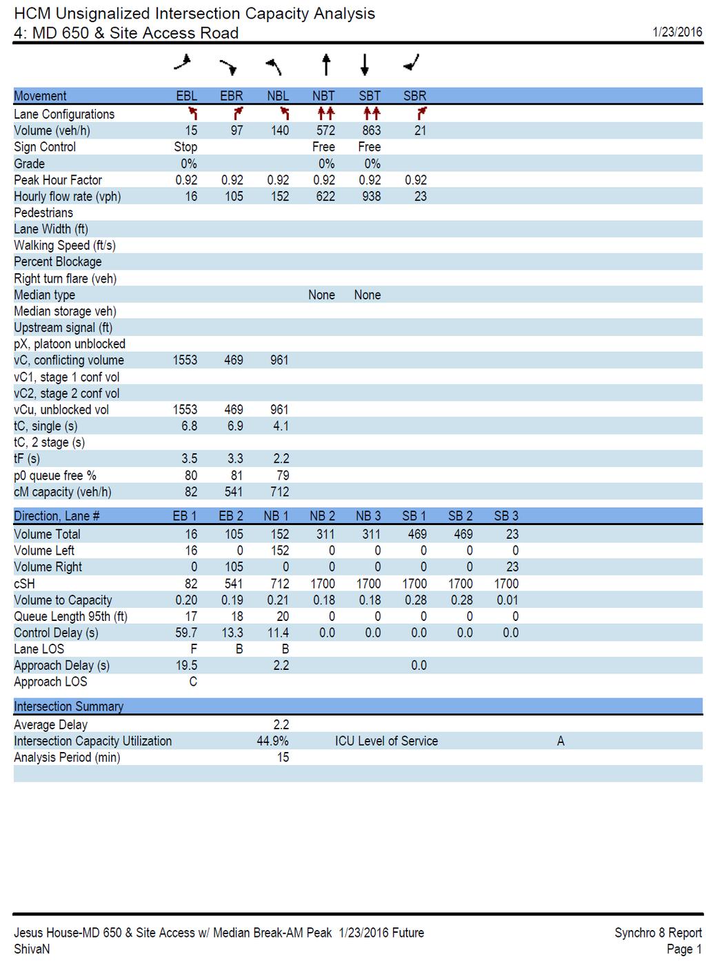
31 traffic pattern, delays will be reduced within the site and, therefore, there will be no risk of spill over traffic into New Hampshire Avenue. There will be at least one off duty police officer to direct traffic at the intersection of New Hampshire Avenue and the site access during the Sunday services As part of this traffic circulation study, we have used SYNCHRO traffic simulation model to evaluate the efficiency of the traffic operation at the site access. The results are summarized in Table 6-1 and output results are included in Appendix D. Table 6-1 SYNCHRO Results- Total Future Intersection Level of Service Analysis at Site Access with Median Break Total Future Intersection Level of Service Analysis Results Scenario Intersection Movement Site Access -W/ Median Break on MD 650 MD 650/Site Access AM Peak Approach LOS 28 95th percentile Queue (feet) PM Peak LOS Delay (seconds/veh) 95th percentile Queue (feet) Delay (seconds/veh) EBL C C EBR Free Flow 0 18 Free Flow 0 22 NBL Free Flow 0 20 Free Flow 0 10 Free flow and no delay for Through Movements on MD 650 and Right Turn Lanes. Overall Intersection LOS A for both AM and PM Peaks As shown in the table above, the median break option will result in an efficient and safe traffic operation as compared to making a U turn at Harding Lane. The safety aspects of the proposed internal and access circulation have been discussed in this section. It is our conclusion that the proposed plan to provide a median break at the site access along New Hampshire Avenue and the internal traffic circulation pattern will provide the best option for safe, efficient and orderly traffic operation in the area. SECTION 7 - CONCLUSIONS The conclusions of this traffic impact study are as follows: 1. Currently, all seven (7) studied intersections operate within the Cloverly congestion standard of 1,450 CLV during the weekday AM and PM peak hours. 2. Sidewalks and other pedestrian amenities including crosswalks, pedestrian signal heads and ADA ramps are not completely adequate at every location partly due to the rural nature of the area. The traffic counts show minimal pedestrian or bicycle traffic at the studied locations. However, adequate sidewalks, wide shoulders and a wide median exist along the site frontage and at newlyconstructed roads and intersections. There are limited bus services to the area but there are bus stops about quarter of a mile to half a mile from the site pipeline developments will generate 167 weekday AM peak hour trips and 270 weekday PM peak hour trips, upon completion.
32 4. With the additional traffic that would be added to the road network by pipeline developments, all seven (7) study intersections would continue to operate within the congestion standard. 5. The proposed new school (350 student K-12th grade) will generate a total of 273 weekday AM and PM peak hour trips and 177 weekday AM and PM net peak hour trips (excluding pass-by and diverted trips.) 6. With the additional traffic that would be added to the road network by the Project, all seven (7) studied intersections and the site access intersection would continue to operate within the congestion standard. 7. The project passes the LATR test. 8. The Project passes the new TPAR test for highway capacity but fails the test for adequacy of transit services. The applicant will pay 25% of the impact tax to mitigate the inadequacy of the transit services and pass the TPAR test. 9. A T-Intersection median break is proposed and is considered by SHA for implementation provided that it complies with the SHA design guidelines. This median break provides for efficient, safe and orderly site generated traffic to enter and exit the site. The overall intersection traffic operates at LOS A. Bothe northbound left turn lane and eastbound left turn lane have a 95 th percentile queue of not exceeding 24 feet either in the AM or PM peak hours. 29
33 APPENDIX A SCOPING DOCUMENTS
34 31
35 32
36 33
37 34
38 APPENDIX B Traffic VOLUME VEHICLE AND PEDESTRIAN CONTS 35
39 36
40 37
41 38
42 39
43 40
44 41
45 42
46 43
47 44
48 45
49 46
50 47
51 48
52 49
53 50
54 51
55 APPENDIX C CRITICAL LAN VOLUME WORKSHEET Existing/Background/Total Future Traffic Conditions 52
56 53
57 54
58 55
59 56
60 57
61 58
62 59
63 60
64 61
65 62
66 63
67 64
68 65
69 66
70 67
71 68
72 69
73 70
74 71
75 72
76 73
77 APPENDIX D SYNCHRO OUTPUT RESULTS 74
78 75

79 76
Ownership Lots 17 & 18 (Part of Lot 14), Montgomery Auto Sales Park
, Montgomery Auto Sales Park") Traffic Impact Analysis Ownership Lots 17 & 18 (Part of Lot 14), Montgomery Auto Sales Park Silver Spring, MD Lot 17: Site Plan No. 821413 Lot 18: Site Plan No. 821414 Filing Number: 13-TS-1198527A Prepared
Traffic Impact Analysis Ownership Lots 17 & 18 (Part of Lot 14), Montgomery Auto Sales Park Silver Spring, MD Lot 17: Site Plan No. 821413 Lot 18: Site Plan No. 821414 Filing Number: 13-TS-1198527A Prepared
Traffic Impact Memorandum. May 22, 2018
 BISHOP PROFESSIONAL DEVELOPMENT BUILDING Proposed Land-use Change & Parking Modification 3601 SW 31st Street Topeka, Kansas 66614 CFS Project No. 185077 Traffic Impact Memorandum May 22, 2018 Prepared
1609 E. FRANKLIN STREET HOTEL TRAFFIC IMPACT STUDY EXECUTIVE SUMMARY
 1609 E. FRANKLIN STREET HOTEL TRAFFIC IMPACT STUDY EXECUTIVE SUMMARY Prepared for: The Town of Chapel Hill Public Works Department Traffic Engineering Division Prepared by: HNTB North Carolina, PC 343
TRAFFIC IMPACT STUDY And A TRAFFIC SIGNAL WARRANT ANALYSIS FOR A SENIOR LIVING AND APARTMENT DEVELOPMENT
 TRAFFIC IMPACT STUDY And A TRAFFIC SIGNAL WARRANT ANALYSIS FOR A SENIOR LIVING AND APARTMENT DEVELOPMENT DEERFIELD TOWNSHIP, WARREN COUNTY, OHIO Nantucket Circle and Montgomery Road () Prepared for: ODLE
5858 N COLLEGE, LLC N College Avenue Traffic Impact Study
 5858 N COLLEGE, LLC nue Traffic Impact Study August 22, 2016 Contents Traffic Impact Study Page Preparer Qualifications... 1 Introduction... 2 Existing Roadway Conditions... 5 Existing Traffic Conditions...
MONTGOMERY COUNTY PLANNING DEPARTMENT THE MARYLAND-NATIONAL CAPITAL PARK AND PLANNING COMMISSION
 MONTGOMERY COUNTY PLANNING DEPARTMENT THE MARYLAND-NATIONAL CAPITAL PARK AND PLANNING COMMISSION SHA CTP Project No. MO891A21, US 29, Fairland Road to Musgrove Road Interchange Improvement, Design Review
TRAFFIC STUDY GUIDELINES Clarksville Street Department
 TRAFFIC STUDY GUIDELINES Clarksville Street Department 9/1/2009 Introduction Traffic studies are used to help the city determine potential impacts to the operation of the surrounding roadway network. Two
Bradford s Landing. Preliminary Plan Abandonment AB753 & AB754 MONTGOMERY COUNTY PLANNING DEPARTMENT
 Bradford s Landing Preliminary Plan 120170060 Abandonment AB753 & AB754 1 Overview Staff recommends Approval of Preliminary Plan 120170060 with revised conditions and Adoption of the Resolution. 244 lots
Transportation Impact Study for Abington Terrace
 Transportation Impact Study for Abington Terrace Abington Township, Montgomery County, PA Sandy A. Koza, P.E., PTOE PA PE License Number PE059911 Prepared by McMahon Associates, Inc. 425 Commerce Drive,
Preliminary Transportation Analysis
 Preliminary Transportation Analysis Goals of a Robust, Multimodal Transportation Network Safe Accessible/Connected Efficient Comfortable Context-Sensitive Motor Vehicle: Continue to analyze the data to
Date: September 7, Project #: Re: Spaulding Youth Center Northfield, NH Property. Traffic Impact Study
 To: Ms. Susan C. Ryan Spaulding Youth Center 72 Spaulding Road Northfield, NH 03276 Date: September 7, 2017 Project #: 52455.00 From: Robin Bousa Director of Transportation Systems Re: Spaulding Youth
INDUSTRIAL BUILDING 3009 HAWTHORNE ROAD CITY OF OTTAWA TRANSPORTATION OVERVIEW REVISED. Prepared for: Canada Inc.
 INDUSTRIAL BUILDING 3009 HAWTHORNE ROAD CITY OF OTTAWA TRANSPORTATION OVERVIEW REVISED Prepared for: 7849648 Canada Inc. Octiober 1, 2015 114-598 Overview_2.doc D. J. Halpenny & Associates Ltd. Consulting
TRANSPORTATION ANALYSIS REPORT US Route 6 Huron, Erie County, Ohio
 TRANSPORTATION ANALYSIS REPORT US Route 6 Huron, Erie County, Ohio December 12, 2012 Prepared for: The City of Huron 417 Main Huron, OH 44839 Providing Practical Experience Technical Excellence and Client
Comments EXECUTIVE SUMMARY
 Comments 1. Under any Alternatives, MCDOT should provide better at-grade pedestrian crossing of Georgia Avenue and Forest Glen Road, including improved crosswalks with wider medians and adequate signal
Walmart (Store # ) 60 th Street North and Marion Road Sioux Falls, South Dakota
 60 th Street North and Marion Road Sioux Falls, South Dakota") Walmart (Store #4865-00) 60 th Street North and Marion Road Sioux Falls, South Dakota Prepared for: Wal-Mart Stores, Inc. Bentonville, Arkansas Prepared by: Kimley-Horn and Associates, Inc. ã2013 Kimley-Horn
Walmart (Store #4865-00) 60 th Street North and Marion Road Sioux Falls, South Dakota Prepared for: Wal-Mart Stores, Inc. Bentonville, Arkansas Prepared by: Kimley-Horn and Associates, Inc. ã2013 Kimley-Horn
Recommended Roadway Plan Section 2 - Land Development and Roadway Access
 Recommended Roadway Plan Section 2 - Land Development and Roadway Access SECTION 2 Land Development and Roadway Access 2.1 Land Use and Access Management The Federal Highway Administration (FHWA) defines
Traffic Impact Analysis Chatham County Grocery Chatham County, NC
 Chatham County Grocery Chatham County, NC TABLE OF CONTENTS 1. INTRODUCTION... 1 1.1. Location and Study Area... 1 1.2. Proposed Land Use and Access... 2 1.3. Adjacent Land Uses... 2 1.4. Existing ways...
MEETING FACILITY 2901 GIBFORD DRIVE CITY OF OTTAWA TRANSPORTATION BRIEF. Prepared for: Holiday Inn Express 2881 Gibford Drive Ottawa, ON K1V 2L9
 MEETING FACILITY 2901 GIBFORD DRIVE CITY OF OTTAWA TRANSPORTATION BRIEF Prepared for: Holiday Inn Express 2881 Gibford Drive Ottawa, ON K1V 2L9 December 18, 2012 112-566 Brief_1.doc D. J. Halpenny & Associates
TAKOMA METRO STATION
 TKOM METRO STTION Traffic nalysis Technical Memorandum Station Planning in Support of Joint evelopment Job No. 13-FQ165-LN-2 November 213 WSHINGTON METROPOLITN RE TRNSIT UTHORITY (WMT) Takoma Metro Station
Traffic Impact Study WestBranch Residential Development Davidson, NC March 2016
 Traffic Impact Study WestBranch Residential Development Davidson, NC March 216 TRAFFIC IMPACT STUDY FOR THE WestBranch Residential Development LOCATED IN DAVIDSON, NC Prepared For: Lennar Carolinas, LLC
NEW YORK CENTRAL PARK SUBDIVISION BLAIS STREET/ST-PIERRE STREET EMBRUN, ONTARIO TRAFFIC IMPACT STUDY. Prepared for:
 NEW YORK CENTRAL PARK SUBDIVISION BLAIS STREET/ST-PIERRE STREET EMBRUN, ONTARIO TRAFFIC IMPACT STUDY Prepared for: Solidex Holdings Limited & Investissement Maurice Lemieux Investments Attn: Mr. Anthony
South Albion-Bolton Community Plan North Hill Supermarket Transportation Study Part B: Evaluation of Alternatives
 Community Plan North Hill Supermarket Transportation Study Part B: Evaluation of Alternatives Prepared for: The Town of Caledon August 9 Transportation Solutions Ltd. 43 Forest Road Cambridge, ON N1S 3B4
SECTION 1 - TRAFFIC PLANNING
 SECTION 1 - TRAFFIC PLANNING 1.1 TRAFFIC OPERATIONS 1.1.1 Roadway Functional Classification The Multnomah County Comprehensive Framework Plan s Policy 34: Trafficways and the Functional Classification
Traffic Impact Study. Westlake Elementary School Westlake, Ohio. TMS Engineers, Inc. June 5, 2017
 TMS Engineers, Inc. Traffic Impact Study Westlake Elementary School Westlake, Ohio June 5, 2017 Prepared for: Westlake City Schools - Board of Education 27200 Hilliard Boulevard Westlake, OH 44145 TRAFFIC
Traffic Impact Study for Rolling Ridge Redevelopment
 Traffic Impact Study for Rolling Ridge Redevelopment Webster Groves, Missouri October 19, 2018 Prepared For: Gershman Commercial Real Estate 150 North Meramec Avenue Suite 500 St. Louis, Missouri 63105
Magnolia Place. Traffic Impact Analysis. Prepared for: City of San Mateo. Prepared by: Hexagon Transportation Consultants, Inc.
 Magnolia Place Traffic Impact Analysis Prepared for: City of San Mateo Prepared by: Hexagon Transportation Consultants, Inc. Updated January 4, 2010 Table of Contents 1. Introduction...1 2. Existing Conditions...6
MEMORANDUM. Matt Folden, AICP, MNCPPC Rebecca Torma, MCDOT. Nancy Randall, AICP, PTP Barbara Mosier, P.E., PTOE Kevin Berger
 To: From: Matt Folden, AICP, MNCPPC Rebecca Torma, MCDOT Nancy Randall, AICP, PTP Barbara Mosier, P.E., PTOE Kevin Berger 1110 Bonifant Street Suite 210, Silver Spring, MD 20910 301-448-1333 WellsandAssociates.com
Highway 111 Corridor Study
 Highway 111 Corridor Study June, 2009 LINCOLN CO. HWY 111 CORRIDOR STUDY Draft Study Tea, South Dakota Prepared for City of Tea Sioux Falls Metropolitan Planning Organization Prepared by HDR Engineering,
Appendix B: Forecasting and Traffic Operations Analysis Framework Document
 Existing Conditions Report - Appendix Appendix B: Forecasting and Traffic Operations Analysis Framework Document This document defines the methodology and assumptions that will be used in the traffic forecasting
TRAFFIC ASSESSMENT River Edge Colorado
 TRAFFIC ASSESSMENT River Edge Colorado Submitted by: Fehr & Peers 621 17th Street, Ste. 231 Denver, CO 8293 (33) 296-43 December, 21 App. M-2 Traffic Assessment River Edge Colorado December 21 TABLE OF
Access Management Regulations and Standards
 Access Management Regulations and Standards January 2014 Efficient highway operation Reasonable property access Concept of Access Management The way to manage access to land development while preserving
9 Leeming Drive Redevelopment Ottawa, ON Transportation Brief. Prepared By: Stantec Consulting Ltd.
 9 Leeming Drive Redevelopment Ottawa, ON Transportation Brief Prepared By: Stantec Consulting Ltd. TIA GUIDELINES CHECKLIST Report Context Municipal Address Comment: Section 1.1 Location relative to major
OFFICE/RETAIL DEVELOPMENT 1625 BANK STREET OTTAWA, ONTARIO TRANSPORTATION BRIEF. Prepared for: Canada Inc.
 OFFICE/RETAIL DEVELOPMENT 1625 BANK STREET OTTAWA, ONTARIO TRANSPORTATION BRIEF Prepared for: 9402209 Canada Inc. December 15, 2015 115-625 Report_2.doc D. J. Halpenny & Associates Ltd. Consulting Transportation
4. ENVIRONMENTAL IMPACT ANALYSIS 9. TRANSPORTATION AND TRAFFIC
 4. ENVIRONMENTAL IMPACT ANALYSIS 9. TRANSPORTATION AND TRAFFIC 4.9.1 INTRODUCTION The following section addresses the Proposed Project s impact on transportation and traffic based on the Traffic Study
Highway 49, Highway 351 and Highway 91 Improvements Feasibility Study Craighead County
 Highway 49, Highway 351 and Highway 91 Improvements Feasibility Study Craighead County Executive Summary March 2015 Highway 49, Highway 351 and Highway 91 Improvements Feasibility Study Craighead County
MONTGOMERY COUNTY PLANNING DEPARTMENT THE MARYLAND-NATIONAL CAPITAL PARK AND PLANNING COMMISSION
 MONTGOMERY COUNTY PLANNING DEPARTMENT THE MARYLAND-NATIONAL CAPITAL PARK AND PLANNING COMMISSION MCPB Item No. 4 Date: 04-17-14 2014 Mobility Assessment Report José Dory, Senior Planner, Functional Planning
TRAFFIC IMPACT STUDY CRITERIA
 Chapter 6 - TRAFFIC IMPACT STUDY CRITERIA 6.1 GENERAL PROVISIONS 6.1.1. Purpose: The purpose of this document is to outline a standard format for preparing a traffic impact study in the City of Steamboat
EXECUTIVE SUMMARY. Page 1 of 6
 EXECUTIVE SUMMARY The purpose of this report is to identify conformance with the original traffic impact study for the proposed retail development on Lot 5 of Riverdale Retail Filing No. 1 located on the
City of Homewood Transportation Plan
 City of Homewood Transportation Plan Prepared for: City of Homewood, Alabama Prepared by: Skipper Consulting, Inc. May 2007 TABLE OF CONTENTS INTRODUCTION... 1 BACKGROUND INFORMATION... 1 EXISTING TRANSPORTATION
4.0 TRAFFIC IMPACT STUDIES
 SECTION 4 4.0 TRAFFIC IMPACT STUDIES 4.1 TRAFFIC IMPACT STUDY REQUIREMENTS The City has established Traffic Impact Study (TIS) requirements for the purpose of ensuring that both the quantitative and qualitative
MEDICAL/OFFICE BUILDING 1637 BANK STREET OTTAWA, ONTARIO TRANSPORTATION OVERVIEW. Prepared for:
 MEDICAL/OFFICE BUILDING 1637 BANK STREET OTTAWA, ONTARIO TRANSPORTATION OVERVIEW Prepared for: 2434984 Ontario Inc. 13-5510 Canotek Road Ottawa, Ontario K1J 9J5 June 4, 2015 115-613 Report_2.doc D. J.
List of Attachments. Location Map... Site Plan... City of Lake Elsinore Circulation Element... City of Lake Elsinore Roadway Cross-Sections...
 List of Attachments Exhibits Location Map... Site Plan... City of Lake Elsinore Circulation Element... City of Lake Elsinore Roadway Cross-Sections... Existing Lane Geometry and Traffic Controls... Existing
MEMORANDUM. David Mohlenbrok, Environmental Services Manager
 MEMORANDUM DATE: August 10, 2017 TO: FROM: RE: Planning Commission Members David Mohlenbrok, Environmental Services Manager Blue Memo # 1 for Rocklin Station Project Comments Received on Initial Study/Mitigated
THIS PAGE LEFT BLANK INTENTIONALLY
 GA SR 25 Spur at Canal Road Transportation Impact Analysis PREPARED FOR GLYNN COUNTY, GEORGIA 1725 Reynolds Street, Suite 300 Brunswick, Georgia 31520 PREPARED BY 217 Arrowhead Boulevard Suite 26 Jonesboro,
Los Altos Hills Town Council - June 18, 2015 Palo Alto City Council June 22, AGENDA ITEM #2.B Presentation
 Los Altos Hills Town Council - June 18, 2015 Palo Alto City Council June 22, 2015 AGENDA ITEM #2.B Presentation Previous Presentations Los Altos Hills Town Council in May 2014 and February 2015 Palo Alto
Abrams Associates. Transportation Impact Analysis. City of Rocklin. Prepared for: David Mohlenbrok City of Rocklin 4081 Alvis Court Rocklin, CA 95677
 Transportation Impact Analysis Sierra College Boulevard Commercial Project City of Rocklin Prepared for: David Mohlenbrok City of Rocklin 081 Alvis Court Rocklin, CA 95677 Prepared by: 1875 Olympic Boulevard,
ALLEY 24 TRAFFIC STUDY
 ALLEY 24 TRAFFIC STUDY in City of Frostburg, Maryland January 2013 3566 Teays Valley Road Hurricane, WV Office: (304) 397-5508 www.denniscorporation.com Alley 24 Traffic Study January 2013 Frostburg, Maryland
REDEVELOPMENT TRAFFIC IMPACT STUDY
 REDEVELOPMENT TRAFFIC IMPACT STUDY For Wendy s Parker, Colorado January 215 Prepared for: Sterling Design Associates, LLC 29 W. Littleton Boulevard #3 Littleton, Colorado 812 Prepared by: 1233 Airport
HENDERSON DEVELOPMENT 213, 217, 221, 221 ½, 223 HENDERSON AVENUE and 65 TEMPLETON STREET OTTAWA, ONTARIO TRANSPORTATION OVERVIEW.
 HENDERSON DEVELOPMENT 213, 217, 221, 221 ½, 223 HENDERSON AVENUE and 65 TEMPLETON STREET OTTAWA, ONTARIO TRANSPORTATION OVERVIEW Prepared for: 2294170 Ontario Inc. February 2, 2017 117-652 Report_1.doc
Windy Ridge Elementary School
 Windy Ridge Elementary School SCHOOL ROUTE PLAN For WINDY RIDGE ELEMENTARY SCHOOL LOCATION 54 ORANGE COUNTY Prepared for: ORANGE COUNTY SCHOOL ASSESSMENT PROGRAM ORANGE COUNTY PUBLIC WORKS Traffic Engineering
Orange Center Elementary School
 Drag and drop pic and stretch/crop to the limits of the blue rectangle (delete this text box) Orange Center Elementary School Drag and drop pic and stretch/crop to the limits of the blue rectangle (delete
Paul VI Redevelopment. Traffic Impact Study
 ATTACHMENT 5 Paul VI Redevelopment Traffic Impact Study April 18, 2017 PAUL VI REDEVELOPMENT TRAFFIC IMPACT STUDY CITY OF FAIRFAX, VIRGINIA Prepared for: IDI GROUP COMPANIES Prepared by: Wells + Associates,
December For more information, call the Area 2 Division at (301)
") December 2013 Appendix B: Transportation Analysis For more information, call the Area 2 Division at (301) 495-4500 GLENMONT SECTOR PLAN TRANSPORTATION APPENDIX November 8, 2013 1 Contents Purpose Transportation
December 2013 Appendix B: Transportation Analysis For more information, call the Area 2 Division at (301) 495-4500 GLENMONT SECTOR PLAN TRANSPORTATION APPENDIX November 8, 2013 1 Contents Purpose Transportation
2014 Mobility Assessment Report Functional Planning & Policy Montgomery County Planning Department
 2014 Mobility Assessment Report Functional Planning & Policy Montgomery County Planning Department Travel Trends National & Local Travel Trends Multi-Modal Monitoring Pedestrian Bikes Bus Rail Future Efforts
Hidden Oaks Elementary School
 Hidden Oaks Elementary School SCHOOL ROUTE PLAN For HIDDEN OAKS ELEMENTARY SCHOOL LOCATION 13 ORANGE COUNTY Prepared for: ORANGE COUNTY SCHOOL ASSESSMENT PROGRAM ORANGE COUNTY PUBLIC WORKS Traffic Engineering
Traffic Impact Analysis Walton Acres at Riverwood Athletic Club Clayton, NC
 Traffic Impact Analysis Walton Acres at Riverwood Athletic Club Clayton, NC 1. TABLE OF CONTENTS INTRODUCTION...1 1.1. Site Location and Study Area...1 1.2. Proposed Land Use and Site Access...2 1.3.
DUNBOW ROAD FUNCTIONAL PLANNING
 DUNBOW ROAD FUNCTIONAL PLANNING Final Report August 3, 216 #31, 316 5th Avenue NE Calgary, AB T2A 6K4 Phone: 43.273.91 Fax: 43.273.344 wattconsultinggroup.com Dunbow Road Functional Planning Final Report
OTTAWA TRAIN YARDS PHASE 3 DEVELOPMENT CITY OF OTTAWA TRANSPORTATION IMPACT STUDY. Prepared for:
 OTTAWA TRAIN YARDS PHASE 3 DEVELOPMENT CITY OF OTTAWA TRANSPORTATION IMPACT STUDY Prepared for: The Ottawa Train Yards Inc. 223 Colonnade Road South, Suite 212 Nepean, Ontario K2E 7K3 January 17, 2012
CITY OF OAKLAND. 27th Street Bikeway Feasibility and Design. Final Report (v3) March 23, Kimley-Horn and Associates, Inc.
 March 23, Kimley-Horn and Associates, Inc.") CITY OF OAKLAND 27th Street Bikeway Feasibility and Design Final Report (v3) March 23, 2007 PREPARED BY: Kimley-Horn and Associates, Inc. Table of Contents 1. Introduction 3 2. 27 th Street/Bay Place Corridor
CITY OF OAKLAND 27th Street Bikeway Feasibility and Design Final Report (v3) March 23, 2007 PREPARED BY: Kimley-Horn and Associates, Inc. Table of Contents 1. Introduction 3 2. 27 th Street/Bay Place Corridor
Gateway Transportation Study
 Gateway Transportation Study Amherst, Massachusetts SUBMITTED TO University of Massachusetts Amherst Town of Amherst SUBMITTED BY Vanasse Hangen Brustlin, Inc. Watertown, Massachusetts March 213 Back of
URBAN QUARRY HEADQUARTERS 2717 STEVENAGE DRIVE CITY OF OTTAWA TRANSPORTATION OVERVIEW. Prepared for: Urban Quarry 4123 Belgreen Drive, Ottawa K1G 3N2
 URBAN QUARRY HEADQUARTERS 2717 STEVENAGE DRIVE CITY OF OTTAWA TRANSPORTATION OVERVIEW Prepared for: Urban Quarry 4123 Belgreen Drive, Ottawa K1G 3N2 February 27, 2014 113-584 Overview_1.doc D. J. Halpenny
TABLE OF CONTENTS TABLE OF CONTENTS... I APPENDICES... III LIST OF EXHIBITS... V LIST OF TABLES... VII LIST OF ABBREVIATED TERMS...
 TABLE OF CONTENTS TABLE OF CONTENTS... I APPENDICES... III LIST OF EXHIBITS... V LIST OF TABLES... VII LIST OF ABBREVIATED TERMS... IX 1 INTRODUCTION... 1 1.1 Project Overview... 1 1.2 Analysis Scenarios...
Peer Review of Highlands Neighborhood Traffic and Pedestrian Safety Plan
 FINAL REPORT March 14, 2017 Prepared for: Ada County Highway District Prepared by: SIX MILE ENGINEERING, PA Executive Summary The (Highlands Safety Plan) developed by the Ada County Highway District (ACHD)
Clackamas County Comprehensive Plan
 ROADWAYS The County s road system permits the movement of goods and people between communities and regions, using any of a variety of modes of travel. Roads provide access to virtually all property. They
INDUSTRIAL BUILDING 1660 COMSTOCK ROAD CITY OF OTTAWA TRANSPORTATION OVERVIEW. Prepared for:
 INDUSTRIAL BUILDING 1660 COMSTOCK ROAD CITY OF OTTAWA TRANSPORTATION OVERVIEW Prepared for: Simluc Contractors Limited 2550 Blackwell Street, Ottawa K1B 5R1 October 18, 2013 113-584 Overview_1.doc D. J.
Truck Climbing Lane Traffic Justification Report
 ROUTE 7 (HARRY BYRD HIGHWAY) WESTBOUND FROM WEST MARKET STREET TO ROUTE 9 (CHARLES TOWN PIKE) Truck Climbing Lane Traffic Justification Report Project No. 6007-053-133, P 101 Ι UPC No. 58599 Prepared by:
FRONT RANGE CROSSINGS TRAFFIC IMPACT STUDY
 FRONT RANGE CROSSINGS TRAFFIC IMPACT STUDY Prepared for: City of Thornton And Colorado Department of Transportation Prepared by: 11 Blake Street, Suite 2 Denver, Colorado 822 Contact: Brian Bern, PE, PTOE
3.9 - Transportation and Traffic
 Transportation and Traffic 3.9 - Transportation and Traffic This section describes the potential transportation and traffic effects of project implementation on the project site and its surrounding area.
Patuxent Green Golf Course
 Patuxent Green Golf Course Laurel, Maryland February 23, 2018 Traffic Impact Analysis Prepared for: ADC Builders Alan Cohen 2701 Tower Oaks Boulevard, Suite 200 Rockville, Maryland 20852 TABLE OF CONTENTS
Los Coyotes Country Club Development Plan Traffic Impact Analysis
 Los Coyotes Country Club Development Plan Traffic Impact Analysis Prepared For: Phil Martin Associates 2073007450 Los Coyotes Country Club Development Plan Traffic Impact Analysis June 19, 2014 Prepared
King Soopers #116 Thornton, Colorado
 Traffic Impact Study King Soopers #116 Thornton, Colorado Prepared for: Galloway & Company, Inc. 1.0 EXECUTIVE SUMMARY King Soopers #116, a grocery marketplace anchored commercial development, is proposed
Henderson Avenue Mixed-Use Development
 Zoning Case: Z145-3 Traffic Impact Analysis Henderson Avenue Mixed-Use Development Dallas, TX October 26 th, 216 Kimley-Horn and Associates, Inc. Dallas, Texas Project #644827 Registered Firm F-928 Traffic
TRAFFIC IMPACT ANALYSIS
 TRAFFIC IMPACT ANALYSIS FOR THE CHAMPAIGN UNIT#4 SCHOOL DISTRICT PROPOSED HIGH SCHOOL (SPALDING PARK SITE) IN THE CITY OF CHAMPAIGN Final Report Champaign Urbana Urbanized Area Transportation Study 6/24/2014
ENHANCED PARKWAY STUDY: PHASE 2 CONTINUOUS FLOW INTERSECTIONS. Final Report
 Preparedby: ENHANCED PARKWAY STUDY: PHASE 2 CONTINUOUS FLOW INTERSECTIONS Final Report Prepared for Maricopa County Department of Transportation Prepared by TABLE OF CONTENTS Page EXECUTIVE SUMMARY ES-1
CarMax Auto Superstore/ Reconditioning Center #6002 Murrieta, California
 CarMax Auto Superstore/ Reconditioning Center #6002 Murrieta, California TUSTIN 17782 17th Street Suite 200 Tustin, CA 92780-1947 714.665.4500 Fax: 714.665.4501 LOS ANGELES 145 S. Spring Street Suite 120
Access Management in the Vicinity of Intersections
 Access Management in the Vicinity of Intersections FHWA-SA-10-002 Technical Summary Photo: Ralph Bentley (used with permission) 0 Access Management is: The design, implementation and management of entry
TRANSPORTATION IMPACT STUDY PROPOSED RIVERFRONT 47 MIXED USE DEVELOPMENT
 November 2016 TRANSPORTATION IMPACT STUDY PROPOSED RIVERFRONT 47 MIXED USE DEVELOPMENT & Aspinwall Borough, Sharpsburg Borough & O Hara Township, Allegheny County, Pennsylvania Prepared for: Riverfront
Meadow Woods Elementary School
 Drag and drop pic and stretch/crop to the limits of the blue rectangle (delete this text box) Meadow Woods Elementary School Drag and drop pic and stretch/crop to the limits of the blue rectangle (delete
D.13 Transportation and Traffic
 This section addresses transportation and traffic issues and impacts related to the Proposed Project. Section D.13.1 provides a description of the affected environment for the Proposed Project. Applicable
Agenda. Overview PRINCE GEORGE S PLAZA METRO AREA PEDESTRIAN PLAN
 PRINCE GEORGE S PLAZA METRO AREA PEDESTRIAN PLAN May 28, 2008 Agenda Welcome and introductions Project overview and issue identification Planning context and strengths Design challenges and initial recommendations
Traffic Analysis and Design Report. NW Bethany Boulevard. NW Bronson Road to NW West Union Road. Washington County, Oregon
 Traffic Analysis and Design Report NW Bethany Boulevard NW Bronson Road to NW West Union Road Washington County, Oregon May 2011 Table of Contents Table of Contents Section 1 Executive Summary... 2 Section
Chapter 6 Transportation Plan
 Chapter 6 Transportation Plan Transportation Plan Introduction Chapter 6 Transportation Plan Transportation Plan Introduction This chapter describes the components of Arvada s transportation system, comprised
Focused Traffic Analysis for the 200 Nellen Avenue Project
 March 13, 2017 Mr. Phil Boyle Town of Corte Madera 300 Tamalpais Drive Corte Madera, CA 94976-0159 Focused Traffic Analysis for the 200 Nellen Avenue Project Dear Mr. Boyle; W-Trans has completed a focused
6060 North Central Expressway Mixed-Use Site Dallas, Texas
 Volume 1 Traffic Impact Analysis 6060 North Central Expressway Mixed-Use Site Dallas, Texas April 30, 2018 Kimley-Horn and Associates, Inc. Dallas, Texas Project #063238300 Registered Firm F-928 Traffic
TRAFFIC IMPACT STUDY. Creekside Thornton, Colorado. For. August 2015 November 2015 Revised: August Prepared for:
 TRAFFIC IMPACT STUDY For Creekside Thornton, Colorado August 215 November 215 Revised: August 216 Prepared for: Jansen Strawn Consulting Engineers 45 West 2 nd Avenue Denver, Colorado 8223 Prepared by:
TRANSPORTATION PLAN INTRODUCTION TRAVEL FORECASTING
 TRANSPORTATION PLAN INTRODUCTION Most of the Upper Rock Creek Planning Area is within one of the County s rural policy areas; only the Derwood section of the Planning Area is outside this rural classification.
CHAPTER 4 TRANSPORTATION IMPACT STUDY TABLE OF CONTENTS
 CHAPTER 4 TRANSPORTATION IMPACT STUDY TABLE OF CONTENTS Section Title Page 4.1 Introduction... 4-1 4.1.1 General... 4-1 4.1.2 Applicant Responsibility... 4-1 4.1.3 Capacity and Safety Issues... 4-1 A.
List of Exhibits...ii
 One Brickell Traffic Study TABLE OF CONTENTS List of Exhibits...ii EXECUTIVE SUMMARY...1 1. INTRODUCTION...2 1.1 Study Area...2 1.2 Study Objective...5 2. EXISTING TRAFFIC CONDITIONS...6 2.1 Data Collection...6
Traffic Circulation Study for Neighborhood Southwest of Mockingbird Lane and Airline Road, Highland Park, Texas
 ARIZONA TEXAS NEW MEXICO OKLAHOMA February 13, 2015 Mr. Meran Dadgostar P.E., R.S. Town of Highland Park 4700 Drexel Dr. Highland Park, Texas 75205 Re: Traffic Circulation Study for Neighborhood Southwest
PRELIMINARY DRAFT WADDLE ROAD / I-99 INTERCHANGE PROJECT ALTERNATIVE ANALYSIS FINAL TRAFFIC SUMMARY REPORT
 PRELIMINARY DRAFT WADDLE ROAD / I-99 INTERCHANGE PROJECT ALTERNATIVE ANALYSIS FINAL TRAFFIC SUMMARY REPORT Prepared by: In Association with: November 2013 EXECUTIVE SUMMARY Patton Township, in partnership
Bistro 6. City of Barrie. Traffic Impact Study for Pratt Hansen Group Inc. Type of Document: Final Report. Project Number: JDE 1748
 City of Barrie Traffic Impact Study for Pratt Hansen Group Inc. Type of Document: Final Report Project Number: JDE 1748 Date Submitted: June 12 th, 2017 06/12/17 John Northcote, P.Eng. Professional License
Glenn Avenue Corridor Traffic Operational Evaluation
 Glenn Avenue Corridor Traffic Operational Evaluation PREPARED FOR: THE CITY OF AUBURN PREPARED BY: DECEMBER 2007 Glenn Avenue Corridor Study--Auburn, Alabama TABLE OF CONTENTS Introduction... 1 Background
joint access drive. will be
 Date: To: From: Subject: June 22, 2015 Bradley Reiner, PE Bowman Consulting David R. Kline, PE, PTOE, Incline Associates Thornton Self-Storage Traffic Analysis (DRAFT) - Thornton, Colorado INTRODUCTION
Michael A. Werthmann, PE, PTOE Principal
 9575 West Higgins Road, Suite 400 Rosemont, Illinois 60018 p: 847-518-9990 f: 847-518-9987 MEMORANDUM TO: FROM: Brian Lorenc GHB-630, LLC Michael A. Werthmann, E, TOE rincipal Luay R. Aboona, E rincipal
APARTMENT BUILDING DEVELOPMENT 1161 HERON ROAD OTTAWA, ONTARIO TRANSPORTATION IMPACT STUDY. Prepared for:
 APARTMENT BUILDING DEVELOPMENT 1161 HERON ROAD OTTAWA, ONTARIO TRANSPORTATION IMPACT STUDY Prepared for: 1649362 Ontario Inc. c/o Manor Park Management 231 Brittany Drive, Suite D Ottawa ON K1K 0R8 July
Intersection Traffic Control Feasibility Study
 Intersection Traffic Control Feasibility Study CSAH 9 at CSAH 60 (185th Avenue) Prepared For: Dakota County Transportation Department Western Service Center 14955 Galaxie Avenue, 3rd Floor Apple Valley,
QUICKIE C STORE AND GAS BAR 1780 HERON ROAD OTTAWA, ONTARIO TRANSPORTATION BRIEF. Prepared for:
 QUICKIE C STORE AND GAS BAR 1780 HERON ROAD OTTAWA, ONTARIO TRANSPORTATION BRIEF Prepared for: Quickie Convenience Stores Larny Holdings Ltd. c/o PBC Group April 15, 2015 115-615 Report_1.doc D. J. Halpenny
Figure 1: Vicinity Map of the Study Area
 ARIZONA TEXAS NEW MEXICO OKLAHOMA May 5, 2016 Mr. Anthony Beach, P.E. BSP Engineers 4800 Lakewood Drive, Suite 4 Waco, Texas 76710 Re: Intersection and Access Analysis along Business 190 in Copperas Cove
CLARKSBURG PREMIUM OUTLETS AT CABIN BRANCH LOCAL AREA TRANSPORTATION REVIEW EXEMPTION STATEMENT
 CLARKSBURG PREMIUM OUTLETS AT CABIN BRANCH LOCAL AREA TRANSPORTATION REVIEW EXEMPTION STATEMENT May 12, 2014 CLARKSBURG PREMIUM OUTLETS AT CABIN BRANCH TRANSPORTATION REVIEW EXEMPTION STATEMENT MONTGOMERY
COMMERCIAL DEVELOPMENT 2015 ROBERTSON ROAD OTTAWA, ONTARIO TRANSPORTATION BRIEF. Prepared for:
 COMMERCIAL DEVELOPMENT 2015 ROBERTSON ROAD OTTAWA, ONTARIO TRANSPORTATION BRIEF Prepared for: First Bay Properties Inc. 311 Richmond Road, Suite 203 Ottawa, ON K1Z 6X3 August 8, 2017 117-663 Brief_1.doc