PUBLIC INPUT MEETING. WHEN? December 15, 2011 Open House: 7:00 p.m. to 8:30 p.m. (CDT) Formal Presentation at 7:30 p.m.
|
|
|
- Franklin Anderson
- 5 years ago
- Views:
Transcription
1 PUBLIC INPUT MEETING WHY? To identify public issues and discuss potential improvements to be considered in the Washington Street Corridor Study in Grand Forks, ND. The study area includes Washington Street from 17 th Ave. S. to 8 th Ave. N. including improvement alternatives for the railroad underpass and the intersection of Washington St. & Demers Ave. WHEN? December 15, 2011 Open House: 7:00 p.m. to 8:30 p.m. (CDT) Formal Presentation at 7:30 p.m. WHERE? Grand Forks City Hall Council Chambers 255 North Fourth Street Grand Forks, ND OPEN HOUSE CONDUCTED BY Kadrmas, Lee & Jackson, Inc. Grand Forks-East Grand Forks Metropolitan Planning Organization (GF-EGFMPO), and the City of Grand Forks Representatives from Kadrmas, Lee & Jackson, Inc., the GF-EGFMPO, and the City of Grand Forks will be on hand to answer your questions and discuss your concerns. WRITTEN STATEMENTS or comments about this project must be mailed or ed by December 30, 2011 to: Jon Markusen, PE Kadrmas, Lee & Jackson, Inc Gateway Drive Suite F Grand Forks, ND jon.markusen@kljeng.com Note Public Input Meeting in subject heading. Kadrmas, Lee & Jackson, Inc. and the GF-EGFMPO will make every reasonable accommodation to provide an accessible meeting facility for all persons. Appropriate provisions for the hearing and visually challenged or persons with limited English Proficiency (LEP) will be made if the meeting conductors are notified 5 days prior to the meeting date, if possible. To request language interpretation, an auxiliary aid or service (i.e., sign language interpreter, accessible parking, or materials in alternative format) contact Earl Haugen of GF-EGFMPO at TTY users may use Relay North Dakota 711 or Materials can be provided in alternative formats: large print, Braille, cassette tape, or on computer disk for people with disabilities or with LEP by Earl Haugen of GF-EGFMPO at TTY users may use Relay North Dakota 711 or
 on December 15, 2011 at the Grand Forks City Hall Council Chambers Room, 255 North 4th Street.")
2 For more information contact: Jon Markusen, P.E. Kadrmas, Lee & Jackson, Inc Public Input Meeting to be held on December 15, 2011 to discuss Washington Street Corridor Study in Grand Forks, ND. A Public Input Meeting will be held from 7:00 p.m. to 8:30 p.m. (CDT) on December 15, 2011 at the Grand Forks City Hall Council Chambers Room, 255 North 4th Street. The Public Input Meeting will utilize an open house format with a formal presentation at 7:30 p.m. (CDT). The purpose of the Public Input Meeting is to present the recommendations for improvements to the corridor, implementation plans and the draft report. The study area includes Washington Street from 17th Ave South to 8th Ave North. The Public Input Meeting will provide the opportunity for public input. Representatives from Kadrmas, Lee & Jackson, Inc., Grand Forks-East Grand Forks Metropolitan Planning Organization (GF-EGFMPO), NDDOT and the City of Grand Forks will be on hand to answer your questions and discuss your concerns. If unable to attend the Public Input Meeting, written statements or comments must be mailed by December 30, 2011 to Jon Markusen, P.E., Kadrmas, Lee & Jackson, Inc., 2750 Gateway Drive Suite F, Grand Forks, ND or jon.markusen@kljeng.com with Public Input Meeting in the subject heading. Kadrmas, Lee & Jackson, Inc. and GF-EGFMPO will make every reasonable accommodation to provide an accessible meeting facility for all persons. Appropriate provisions for the hearing and visually challenged or persons with limited English proficiency (LEP) will be made if the Department is notified 5 days prior to the meeting date, if possible. To request language interpretation, an auxiliary aid or service (i.e., sign language interpreter, accessible parking, or materials in alternative format) contact Earl Haugen of GF-EGFMPO, at TTY users may use Relay North Dakota 711 or Materials can be provided in alternative formats: large print, Braille, cassette tape, or on computer disk for people with disabilities or with LEP by contacting Earl Haugen of GF- EGFMPO, at TTY users may use Relay North Dakota 711 or
3 ###
4 Public Input M eeting Washington Street Corridor Study and Underpass Evaluation Report Why? To identify public issues and discuss potential improvements to be considered in the Washington Street Corridor Study in Grand Forks, ND. The study area includes Washington Street from 17th Ave. S. to 8th Ave. N. including improvement alternatives for the railroad underpass and the intersection of Washington St. and Demers Ave. Public Input M eeting Washington Street Corridor Study and Underpass Evaluation Report Why? To identify public issues and discuss potential improvements to be considered in the Washington Street Corridor Study in Grand Forks, ND. The study area includes Washington Street from 17th Ave. S. to 8th Ave. N. including improvement alternatives for the railroad underpass and the intersection of Washington St. and Demers Ave. When and Where? Thursday, December 15, 2011 Open House: 7:00 pm to 8:30 pm (CDT) Formal Presentation at 7:30 pm Grand Forks City Hall - Council Chambers 255 North Fourth Street Grand Forks, ND When and Where? Thursday, December 15, 2011 Open House: 7:00 pm to 8:30 pm (CDT) Formal Presentation at 7:30 pm Grand Forks City Hall - Council Chambers 255 North Fourth Street Grand Forks, ND Public Input M eeting Washington Street Corridor Study and Underpass Evaluation Report Why? To identify public issues and discuss potential improvements to be considered in the Washington Street Corridor Study in Grand Forks, ND. The study area includes Washington Street from 17th Ave. S. to 8th Ave. N. including improvement alternatives for the railroad underpass and the intersection of Washington St. and Demers Ave. Public Input M eeting Washington Street Corridor Study and Underpass Evaluation Report Why? To identify public issues and discuss potential improvements to be considered in the Washington Street Corridor Study in Grand Forks, ND. The study area includes Washington Street from 17th Ave. S. to 8th Ave. N. including improvement alternatives for the railroad underpass and the intersection of Washington St. and Demers Ave. When and Where? Thursday, December 15, 2011 Open House: 7:00 pm to 8:30 pm (CDT) Formal Presentation at 7:30 pm Grand Forks City Hall - Council Chambers 255 North Fourth Street Grand Forks, ND When and Where? Thursday, December 15, 2011 Open House: 7:00 pm to 8:30 pm (CDT) Formal Presentation at 7:30 pm Grand Forks City Hall - Council Chambers 255 North Fourth Street Grand Forks, ND
5 Kadrmas, Lee & Jackson 2750 Gateway Drive Suite F, Grand Forks, ND Kadrmas, Lee & Jackson and the GF-EGFMPO will make every reasonable accommodation to provide an accessible meeting facility for all persons. Appropriate provisions for the hearing and visually challenged or persons with limited English proficiency will be made if notification is provided five days prior to the meeting date, if possible. To request language interpretation, an auxiliary aid or service (i.e., sign language interpreter, accessible parking, or materials in alternative format) contact Earl Haugen of GF-EGFMPO, at TTY users may use Relay North Dakota 711 or If unable to attend the meeting, written statements or comments about this project must be mailed or ed by December 30, 2011 to Jon Markusen, PE, Kadrmas, Lee & Jackson, Inc., 2750 Gateway Drive Suite F, Grand Forks, ND or Jon at com, note Public Input Meeting in subject heading. Kadrmas, Lee & Jackson 2750 Gateway Drive Suite F, Grand Forks, ND Kadrmas, Lee & Jackson and the GF-EGFMPO will make every reasonable accommodation to provide an accessible meeting facility for all persons. Appropriate provisions for the hearing and visually challenged or persons with limited English proficiency will be made if notification is provided five days prior to the meeting date, if possible. To request language interpretation, an auxiliary aid or service (i.e., sign language interpreter, accessible parking, or materials in alternative format) contact Earl Haugen of GF-EGFMPO, at TTY users may use Relay North Dakota 711 or If unable to attend the meeting, written statements or comments about this project must be mailed or ed by December 30, 2011 to Jon Markusen, PE, Kadrmas, Lee & Jackson, Inc., 2750 Gateway Drive Suite F, Grand Forks, ND or Jon at com, note Public Input Meeting in subject heading. Kadrmas, Lee & Jackson 2750 Gateway Drive Suite F, Grand Forks, ND Kadrmas, Lee & Jackson and the GF-EGFMPO will make every reasonable accommodation to provide an accessible meeting facility for all persons. Appropriate provisions for the hearing and visually challenged or persons with limited English proficiency will be made if notification is provided five days prior to the meeting date, if possible. To request language interpretation, an auxiliary aid or service (i.e., sign language interpreter, accessible parking, or materials in alternative format) contact Earl Haugen of GF-EGFMPO, at TTY users may use Relay North Dakota 711 or If unable to attend the meeting, written statements or comments about this project must be mailed or ed by December 30, 2011 to Jon Markusen, PE, Kadrmas, Lee & Jackson, Inc., 2750 Gateway Drive Suite F, Grand Forks, ND or Jon at com, note Public Input Meeting in subject heading. Kadrmas, Lee & Jackson 2750 Gateway Drive Suite F, Grand Forks, ND Kadrmas, Lee & Jackson and the GF-EGFMPO will make every reasonable accommodation to provide an accessible meeting facility for all persons. Appropriate provisions for the hearing and visually challenged or persons with limited English proficiency will be made if notification is provided five days prior to the meeting date, if possible. To request language interpretation, an auxiliary aid or service (i.e., sign language interpreter, accessible parking, or materials in alternative format) contact Earl Haugen of GF-EGFMPO, at TTY users may use Relay North Dakota 711 or If unable to attend the meeting, written statements or comments about this project must be mailed or ed by December 30, 2011 to Jon Markusen, PE, Kadrmas, Lee & Jackson, Inc., 2750 Gateway Drive Suite F, Grand Forks, ND or Jon at com, note Public Input Meeting in subject heading.
6 Attendee Ardin Strifel Brad Towers Craig Amiot Dan Sampson Greg Nelson Jerry Baker Jon Markusen Ken Towers Leonard Bina Matt Walkowiak Michael Johnson Mike Bittner Sharon Shauer Sia-Anvarinia Title/Representing North Dakota Department of Transportation - Local Government Italian Moon 5-Star Collision Omega Properties B&N Oil Co. Did Not Specify Kadrmas, Lee & Jackson Italian Moon Property Owner Paradiso Mexican Restaurant North Dakota Department of Transportation - Local Government Kadrmas, Lee & Jackson Property Owner Paradiso Mexican Restaurant


7 Washington Street Corridor Study Grand Forks-East Grand Forks Metropolitan Planning Organization Public Input Meeting Number 4 December 15 th,2011
8 Presentation Outline Public Input Meeting Review Underpass Review and Recommendations Study Recommendations Vehicular Improvements Pedestrian Improvements Bicycle Improvements Transit Improvements Right-Of-Way Impacts Implementation Schedule Next Steps
9 PUBLIC INPUT MEETING REVIEW
10 Public Input Meeting Review Public Input Meeting 1 Project Overview Review of corridor study objectives Discussion of traffic issues and public concerns Access Management Previous Studies Structure update Public Input Meeting 2 Briefing on Study Results Structure Analysis Summary of Traffic Analysis Results: Traffic Flow and Levels of Service Bicycle/Pedestrian Safety and Accessibility Public Transportation
11 Public Input Meeting Review Public Input Meeting 3 Review of Access Management and Multimodal Improvement Alternatives Discussion of alternatives for access control, pedestrian, bicycle and transit provisions DeMers Avenue intersection update Morning meeting designated for businesses north of DeMers Avenue Afternoon meeting designated for businesses north of DeMers Avenue Evening presentation designated for all public
12 UNDERPASS REVIEW AND RECOMMENDATIONS
 and alkali-silica reaction (ASR) ACR and ASR not found in the east bridge span")
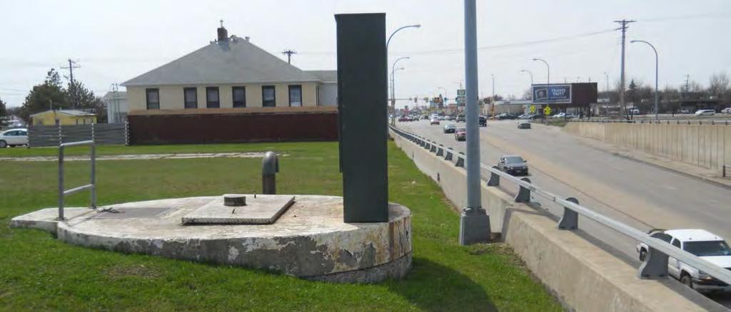
13 Underpass Evaluation Review Widespread cracking present in the portion of the bridge constructed in 1937 Caused by irreversible alkali-carbonate reaction (ACR) and alkali-silica reaction (ASR) ACR and ASR not found in the east bridge span built in 1964
14 Underpass Evaluation Review Superstructure and retaining walls also exhibit deterioration Pavement underneath the bridge at or near the end of useful life Lift station #183 adjacent to underpass currently undersized Bicycle accommodations underneath the bridge do not meet AASHTO design guidelines


15 Underpass Evaluation Review
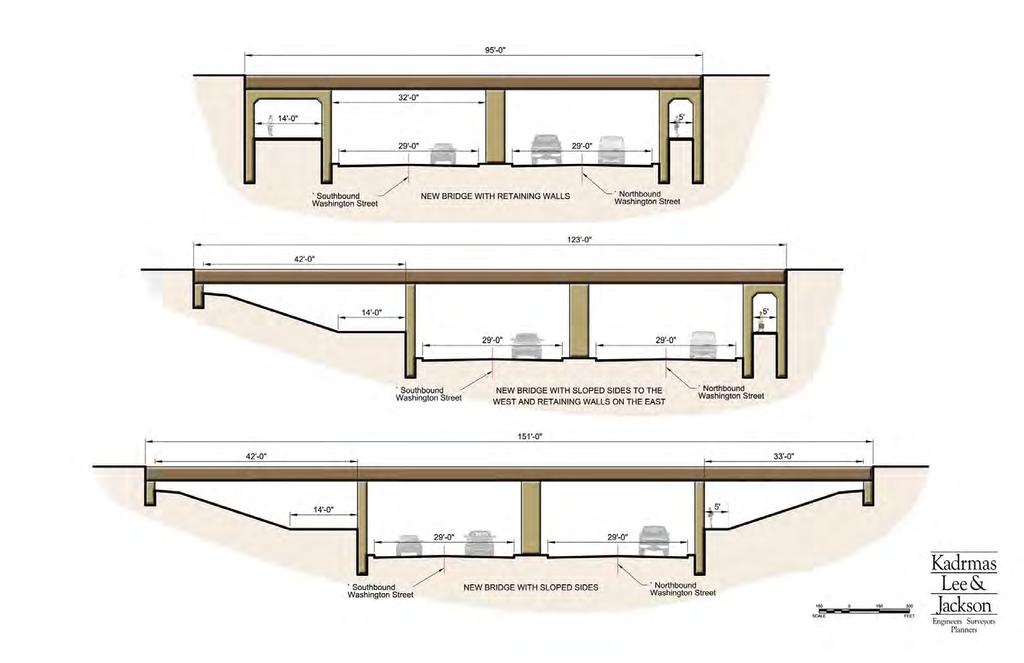
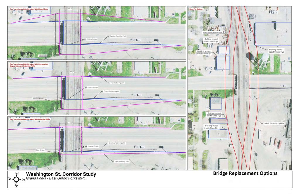
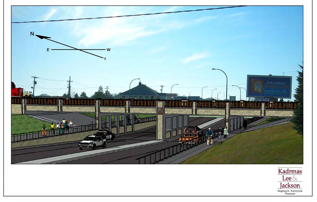
16 Underpass Recommendation Deficiency: Bridge deterioration in west bridge span Recommendation: Full bridge replacement Existing lane configuration Expanded bicycle facility on west side of underpass Replace Lift Station #183 Expand bridge width (BNSF request) Discarded Alternatives: Short-term repair Partial bridge replacement Expanded bridge with additional NB/SB lanes
17
18
19

20
21 Underpass Alternatives Underpass alternatives (2011 cost): Sloped Sections: $4,843,000 Retaining Walls: $4,069,000 Combination Sloped Sections/Retaining Walls: $4,812,000 Shoo-fly cost: $1,704,000 (2011 cost) Most expensive alternative: north side shoo-fly
22 RECOMMENDATIONS VEHICULAR IMPROVEMENTS
23 Corridor Pavement Deficiency: Pavement North of Hammerling at or near the end of useful life Recommendation: Reconstruct Corridor North of Hammerling Avenue Existing basic lane configuration Narrow lanes to 12 (allows widening sidewalk 2 on each side) South of Hammerling only requires rehabilitation Discarded Alternatives: Expanded roadway geometry Positively Offset Turn Lanes
24 Access Management Deficiency: Crash and traffic flow concerns related to dense driveway spacing Up to 3.8 times Average State and County crash rates Recommendation: Implement Access Management Plan Discarded Alternatives: Raised Medians
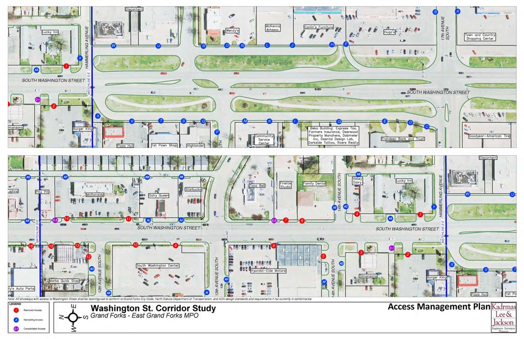
25
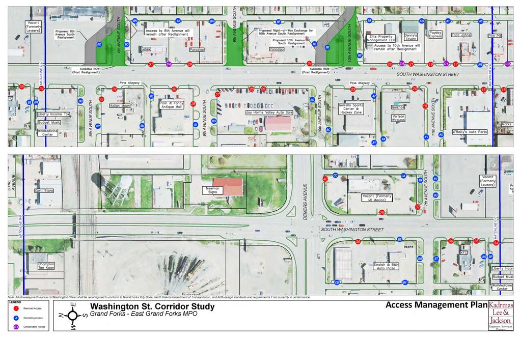
26

27
28 Access Management Access Management Plan may vary during project development Project development is not anticipated for several years Final access management plan should strike balance between motor vehicle crash susceptibility and business access and functionality Studies have found that as the number of access points per mile increase, the accident rate also increases

29 Signal Network Deficiency: Current signal system incapable of desired communication/data transfer Recommendation: Install new traffic signal interconnection hardwire throughout the corridor

30 17 th Avenue South Deficiency: SB through lane queue lengths are anticipated to exceed existing full-width turnlane lengths. Recommendation: Extend turn-lanes
31 15 th Avenue South Deficiency: Intersection delays reach unacceptable levels by 2035 Recommendation: Install right-turn lanes on 15 th Avenue South Approaches Discarded Alternative: Side-street realignment

32 15 th Avenue South
33 14 th,10 th & 8 th Avenues South Deficiency: Negatively offset intersections cause crash and traffic operations concerns Recommendation: Realign 14 th, 10 th and 8 th Avenues South (WB approaches) Discarded Alternatives: Realign eastbound approaches Install additional turn-lanes on minor approaches

34 14 th Avenue South

35 10 th Avenue South

36 8 th Avenue South
37 7 th Avenue South Deficiency: Crash and operational concerns related to combination left/through lane on SB 7 th Avenue South Crashes related to NB DeMers Avenue spillback across 7 th Avenue South intersection Recommendation: Stripe SB left-turn lane at 7 th Avenue South Discarded Alternative: Restricted 7 th Avenue South access

38 7 th Avenue South
39 DeMers Avenue Deficiency: Capacity and operational deficiencies Crash concerns at the intersection Spillback causing crash and operation concerns at adjacent intersections Recommendation: Continuous flow intersection with additional EB and WB through lane With or without new south river crossing
40 DeMers Avenue Discarded Alternatives: Interchange Roundabout Jughandle Fly-Over NB and SB Lane Expansion Improvements to complimentary corridors

41 DeMers Intersection

42 DeMers Avenue Intersection
43 DeMers Avenue Intersection Benefits versus existing configuration: *90% reduction in motorist delay *75% reduction in fuel consumption *35-50% reduction in vehicle emissions *70% and *85% queue length reduction on Washington Street and DeMers Avenue respectively Reduced pedestrian exposure Controlled channelized right-turn movements Potential rear-end crash reduction at 4 th Avenue South On-Ramp to DeMers Avenue *Data specific to 2035 Peak-Hour Traffic Conditions with 32 nd Avenue River Crossing
44 2 nd Avenue North Deficiency: Traffic signal unwarranted through study horizon Signal removal offers operations and crash reduction benefits Recommendation: Replace traffic control signal with two-way stop control

45 2nd Avenue North
46 University Avenue Deficiency: NB and SB left-turn crash rate higher than expected when compared to the remaining corridor Recommendation: Install NB and SB protected/permissive left-turn phasing with flashing yellow arrow Discarded Alternative: Install NB and SB exclusive protected left-turn phase
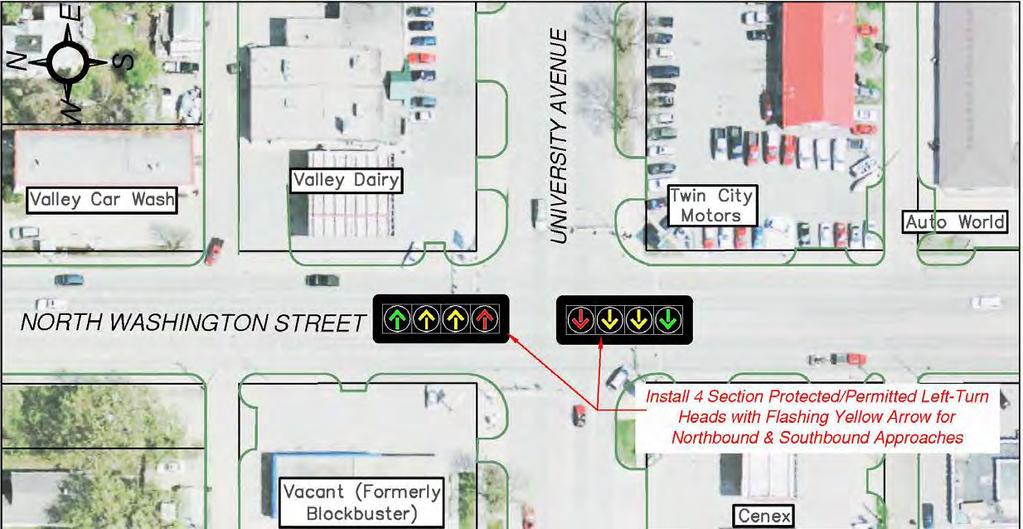
47 University Avenue
48 8 th Avenue North Deficiency: Intersection meets MUTCD Warrant 9 (Intersection Near a Grade Crossing) Potential for vehicles queuing across tracks during peak hours of the day Past public requests for improved pedestrian crossing across Washington at this location Recommendation: Install traffic control signal with railroad preemption

49 8th Avenue North
50 RECOMMENDATIONS PEDESTRIAN IMPROVEMENTS


51 Pedestrian Improvements Deficiencies: Sidewalks do not meet ADA side-slope standards across private driveways and alleyways Sidewalks are adjacent to vehicle activity along Washington Street Utilities currently within sidewalk do not meet ADA width requirements and act as obstacles for snow removal
52 Pedestrian Improvements Recommendations: Install 5 foot sidewalk with 2 feet of stamped concrete Route sidewalks around driveway and alleyway aprons Requires 5 feet of ROW acquisition at driveway locations Relocate utilities outside of sidewalk footprint where feasible Discarded Alternative: Boulevards
53
 High Transit Usage Potential vehicle-pedestrian crashes and conflicts at existing crosswalk")
54 9 th Avenue South Deficiency: Pedestrian mobility gap across Washington Street between DeMers & 13 th Avenue South (1/2 Mile) High Transit Usage Potential vehicle-pedestrian crashes and conflicts at existing crosswalk markings
 Traffic")
55 9 th Avenue South Recommendation: Install Pedestrian Hybrid Beacon South of 9 th Avenue South Pending 9 th Avenue South WB Approach closure Discarded Alternative: Flashing beacon (unless 9 th Avenue approach not closed) Traffic signal

56 9 th Avenue South
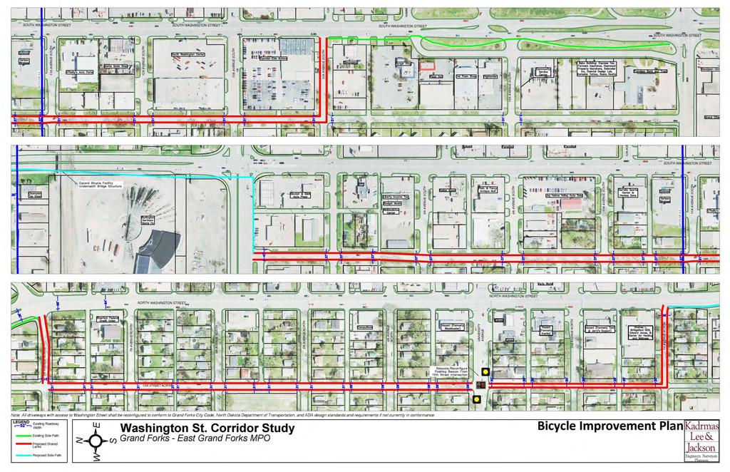
57 RECOMMENDATIONS BICYCLE IMPROVEMENTS
58 Bicycle Improvements Deficiencies: No off-street bicycle facilities exist between Hammerling Avenue and 8 th Avenue North Sharing the roadway with vehicles on Washington Street may be undesirable Recommendation: Implement Alternate Bicycle Route on 14 th Street Shared lanes on 14 th Street Relocate Pedestrian Beacon at University/North 15 th Street to University/North 14 th Street Expand multi-purpose facility underneath Washington Street Underpass to accommodate twoway bicycle activity
59


60 Bicycle Improvements

61 Bicycle Improvements Discarded Alternatives: Off-street bicycle facility along Washington Street Side Path or Bike Lane along alternate bicycle route Dyke Avenue Side Path Side Paths along University Avenue between 14th and Washington Street
62 RECOMMENDATIONS TRANSIT IMPROVEMENTS
63 Transit Improvements Deficiency: Bus stops along corridor causes traffic congestion Recommendations: Install bus turn-outs at specific locations throughout the corridor Restrict bus pick-ups/drop-offs to turn-out locations Discarded Alternatives: Bus Shelters

64
65 RECOMMENDATIONS Right-Of-Way Impacts
66 Right-Of-Way Impacts Bridge Improvement Shoo-Fly Impacts to buildings either to the north or south Minor ROW acquisition for bridge with sloped sections Roadway Improvements NW Quadrant of DeMers Avenue Intersection Central Fire Station Remodel Xcel Energy Storage Area 8 th & 10 th Avenue South Realignments
67 Right-Of-Way Impacts Pedestrian Improvements 5 at all driveways with access to Washington St. Utility easements at locations where utilities are relocated outside of the sidewalk Bicycle Improvements Minor ROW acquisition to expand bicycle facility under the railroad bridge structure Transit Improvements ROW acquisition required at 3 of the 4 bus turnout locations
68 IMPLEMENTATION SCHEDULE
69 Implementation Schedule Two implementation strategies used: 1. Prioritization based strategy a) Based solely upon the needs of the corridor b) Does not account for regional improvement and financial constraints c) Assumes proper maintenance of the existing and proposed infrastructure d) Segregates reconstruction projects and standalone projects e) All improvement costs represent 2011 values for comparative purposes
70 ¹Cost conservatively represents the highest cost bridge alternative. This alternative includes full bridge replacement with sloped sections. Full Reconstruction Project Priority 2011 Cost 1 st Avenue North to 5 th Avenue South Full Reconstruct¹ Burlington Northern Sante Fe Railway bridge reconstruction o Right-Of-Way acquisition o Storm sewer lift station #183 upgrade and replacement Full pavement reconstruction o Signage and pavement markings o Utilities adjustments Reconstruct pedestrian and bicycle facilities Lighting rehabilitation $11,891,000 Federal $9,512,800 State $1,189,100 Local $1,189,100 5 th Avenue South to 7 th Avenue South Full Reconstruct Continuous flow intersection at Washington Street and DeMers Avenue Intersection o Installation of new traffic signal and lighting systems o Overhead signage, at grade signage and pavement markings o Right-Of-Way acquisition o Fire Station reconfiguration o 4th Avenue South/5th Avenue South DeMers Access Reconfiguration Full pavement reconstruction o Access management and driveway modifications o Signage and pavement markings o Utilities adjustments and improvements Reconstruct pedestrian facilities o Relocate utilities outside sidewalk footprint $11,716,269 Federal $9,373,015 State $1,171,627 Local $1,171,627 7 th Avenue South to Hammerling Avenue Full Reconstruct Full pavement reconstruction o Access management and driveway modifications o Signage and pavement markings o Utilities adjustments o 8th, 10th and 14th Avenue South realignments Pedestrian beacon south of 9th Avenue South Reconstruct pedestrian facilities o Relocate utilities outside sidewalk footprint Bus turn-outs Traffic signal and lighting rehabilitation $6,456,000 Federal $5,164,800 State $645,600 Local $645,600
71 Full Reconstruction Project Priority 2011 Cost 8 th Avenue North to 1 st Avenue North Full Reconstruct Full pavement reconstruction o Access management and driveway modifications o Signage and pavement markings o Utilities adjustments Reconstruct pedestrian facilities o Relocate utilities outside sidewalk footprint Traffic signal and lighting rehabilitation $5,008,000 Federal $4,006,400 State $500,800 Local $500,800 Hammerling Avenue to 17 th Avenue Full Reconstruct All projects within this segment of the corridor shall be addressed as standalone projects Outside Study Horizon
72 ¹Cost is based upon the assumption that the existing mast arms are able to withstand new wind loading resulting from replacing the existing 3-section signal heads with 4-section traffic signal heads. ²Cost assumes that roadway widening is not required to implement an alternate bicycle route adjacent to the corridor. Standalone Project Priority 2011 Cost 2 nd Avenue North Intersection Signal Replacement with Two-Way Stop Control 8 th Avenue North Traffic Signal Installation University Avenue Northbound and Southbound Left- Turn Improvements ¹ Alternate Bicycle Route Adjacent to Corridor ² Traffic Signal Fiber Optic Interconnect 15 th Avenue South Right Turn-Lane Installation 17 th Avenue South Turn-Lane Modifications $72,000 Federal $57,600 State $7,200 Local $7,200 $312,000 Federal $249,600 State $31,200 Local $31,200 $19,000 Federal $15,200 State $1,900 Local $1,900 $173,000 Federal $138,400 State $17,300 Local $17,300 $685,000 Federal $548,000 State $68,500 Local $68,500 $85,000 Federal $68,000 State $8,500 Local $8,500 $97,000 Federal $77,600 State $9,700 Local $9,700
73 Implementation Schedule 2. Strategy with Regional Considerations a) Based upon coordination with NDDOT and the City of Grand Forks b) Considers full reconstruction, standalone and rehabilitation projects c) Costs forecasted to projected planning term a) Terms based upon existing LRTP terms and TIP applicability d) Future costs are inflated using the Grand Forks East Grand Forks MPO standard rate of 4% compounded annually
74 Implementation Plan with Regional Considerations Planning Term Programming Cost (1st Year of Term) Programming Cost (Mid-Term Year) Programming Cost (Last Year of Term) 32nd Avenue South to Hammerling Avenue Preventive Maintenance ¹ Mid- Term $2,281,224 $2,566,067 $2,886,476 Federal $1,824,979 Federal $2,052,854 Federal $2,309,181 State $228,122 State $256,607 State $288,648 Local $228,122 Local $256,607 Local $288,648 1st Avenue North to 5th Avenue South Full Reconstruct (Include Underpass Improvements) ² Mid- Term $14,466,859 $16,273,248 $18,305,191 Federal $11,573,487 Federal $13,018,599 Federal $14,644,153 State $1,446,686 State $1,627,325 State $1,830,519 Local $1,446,686 Local $1,627,325 Local $1,830,519 8th Avenue North to 1st Avenue North Full Reconstruct Long- Term $8,017,637 $10,144,869 $12,836,495 Federal $6,414,110 Federal $8,115,895 Federal $10,269,196 State $801,764 State $1,014,487 State $1,283,650 Local $801,764 Local $1,014,487 Local $1,283,650 7th Avenue South to Hammerling Avenue Full Reconstruct Long- Term $10,336,000 $13,078,337 $16,548,269 Federal $8,268,800 Federal $10,462,670 Federal $13,238,615 State $1,033,600 State $1,307,834 State $1,654,827 Local $1,033,600 Local $1,307,834 Local $1,654,827 ¹The majority of this project is beyond the project limits and scope of this study. This cost represents an NDDOT estimate and is not included in the Appendix. ²Cost conservatively represents the highest cost bridge alternative. This alternative includes full bridge replacement with sloped sections.
75 Implementation Plan with Regional Considerations Planning Term Programming Cost (1st Year of Term) Programming Cost (Mid-Term Year) Programming Cost (Last Year of Term) Alternate Bicycle Route Adjacent to Corridor ² Long- Term $276,722 $350,142 $443,041 Federal $221,378 Federal $280,114 Federal $354,433 State $27,672 State $35,014 State $44,304 Local $27,672 Local $35,014 Local $44,304 Traffic Signal Fiber Optic Interconnect Long- Term $1,097,052 $1,388,121 $1,756,416 Federal $877,642 Federal $1,110,497 Federal $1,405,133 State $109,705 State $138,812 State $175,642 Local $109,705 Local $138,812 Local $175,642 5th Avenue South to 7th Avenue South Full Reconstruct (Include DeMers Avenue Intersection Improvements) Long- Term $18,758,124 $23,735,011 $30,032,361 Federal $15,006,499 Federal $18,988,009 Federal $24,025,889 State $1,875,812 State $2,373,501 State $3,003,236 Local $1,875,812 Local $2,373,501 Local $3,003,236 2 nd Avenue North Intersection Signal Replacement with Two- Way Stop Control, 8th Avenue North Traffic Signal Installation, University Avenue Northbound and Southbound Left-Turn Improvements, 15th Avenue South Right Turn-Lane Installation & 17th Avenue South Turn-Lane Modifications Part of Another Priority Part of Another Priority Part of Another Priority ³Cost assumes that roadway widening is not required to implement an alternate bicycle route adjacent to the corridor. Part of Another Priority
76 NEXT STEPS
77 Next Steps Make revisions to draft report Final Report presentation at Safety Service Meeting
78 X elenergy Real Estate Services 1800 Larimer Street Suite900 Denver, O December 14, 2011 CERTIFIED MAIL # RETURN RECEIPT REQUESTED Grand Forks - East Grand Forks Metropolitan Planning Organization P.O. Box 5200 Grand Forks, ND Re: Washington Street Corridor Study, Bridge Replacement Options Dear Sir/Madam: On behalf of Northern States Power Company-Minnesota, an Xcel Energy Company (NSPM), I am contacting you to convey NSPM s comments regarding the proposed options for the abovereferenced bridge replacement project. As you know, NSPM owns property and facilities located at th Avenue South that may be affected by this project. After an analysis of the proposed options, NSPM has determined that the northern Shoo-Fly will have the least impact on the NSPM operations for the following reasons: The southern Shoo-Fly, as currently configured, would negatively impact material storage areas presently in use. The southern Shoo-Fly would require the demolition and reconfiguration of the northern exterior wall of our facility. This demolition and reconstruction would diminish our warehouse space and be disruptive to our workforce. The financial impacts of this demolition and reconstruction has not yet been determined. The southern Shoo-Fly and resultant proximity of rail traffic would result in additional vibration, noise, and potential impacts on indoor air quality, which present safety, health and security concerns. Thank you forthe opportunity to provide our comments on this major improvement issue. Sincerely, Terr~; L. Laudick Real Estate Asset & Portfolio Manager
79
80

81
82
83

84 January 12, 2011 Paradiso Mexican Restaurant 905 South Washington Street Grand Forks, ND Re: Washington Street Corridor Study Comments Dear Paradiso Mexican Restaurant: We appreciate your input and understand your concerns. Public input is a crucial part of the planning process. All of the public input we have received regarding this study has been documented in the report which will be available to the public soon. There is a considerable balancing act between limiting business impacts and promoting safe and efficient traffic flow. Although, it is highly unlikely that nothing will change along the corridor, we are fully confident that a solution that is satisfactory at meeting both goals can be achieved during the project development phase. The purpose of this study is to provide insight into the possible impacts related to roadway safety and traffic operation improvements when/if a project proceeds. Regarding your concern over losing parking spaces, we would like to expand upon your initial analysis: nd AveSSuite201 PO Box 9767 Fargo, ND Fax kljeng.com The lost parking spaces resulting from the new driveway proposed to be shared with Cenex would result in half as many parking spaces lost as anticipated due to the proposed location of this driveway. This driveway is planned to be located approximately half on the Paradiso property and half on the Cenex property. Based upon the data you provided for your parking loss for a new driveway (4 lost parking spots), conversely the two removed driveways onto Washington Street would result in approximately 8 gained parking spots. Currently parking is prohibited throughout the majority of 10 th Avenue South adjacent to your establishment. When the 10 th Avenue South roadway is reconstructed, it could be designed to provide similar parallel parking opportunities that are present on 9 th Avenue South. As you have noted in your message, the main entrance is the only entrance that is handicap accessible. Our preliminary measurements indicate that the parallel parking spaces currently located on 9 th Avenue South are approximately the same distance away from the front door as the proposed parallel parking spaces located on the realigned 10 th Avenue South roadway. This results in an almost negligible change to parallel parking.
85 The proposed access point on 10 th Avenue South is an approximate location and will be appropriately located as to not interfere with the existing parking layout of your property during project development. Based upon your original analysis you anticipated a reduction in 36 spaces. Refining your original data to reflect the analysis documented above, one would anticipate the following changes (It is important to note that actual parking losses and gains cannot be fully projected until project development): 10 th Avenue South Realignment: -21 Spaces Bus Turn-Out: -6 Spaces Shared Cenex Driveway: -2 Spaces Removed Driveways: +8 Spaces Lost Parallel Parking on 9 th Avenue South: -22 Spaces* Gained Parallel Parking on 10 th Avenue South: +22 Spaces* Parking Lot Development on Abandoned 9 th Avenue: +25 Spaces Net Parking Loss: +4 Spaces *Preliminary analysis by KLJ indicates that these estimates may be high but result in negligible impact to overall parking. The following bullets related to your proposed business mitigation options: Relocate the Bus Turn-Out: Our analysis indicated similar bus turn-out impacts to all of the businesses north and south of your property. This location was selected based upon existing transit pick-up and drop-off data combined with pedestrian-vehicle crash data and proximity to adjacent signalized intersections. It is important to note that this location may vary during project development. Award the Vacated Section of 10 th Avenue South to Paradiso Mexican Restaurant for parking: The use of this vacated area shall be determined by the City of Grand Forks. We will pass along your interest for this section of land to the appropriate decision maker. Award the House Located at 908 South 12 th Street and Buy the House at 908 South 12 th Street for the Purpose of Providing Additional Paradiso Mexican Restaurant Parking: The house located at 908 South 12 th Street was sold by the City to a family as part of the City's Neighborhood Stabilization Program with certain resale restrictions. In regards to your concern over losing your southern-most Washington Street access: if it is determined during project development that your business could not properly function without this access, several provisions could be made ranging from additional signage to right-in only access point. In regards to your concern regarding raised medians, the access management plan we have developed has limited the number of non-intersection access locations to the point that a raised median has been deemed unnecessary. If a relaxed access Page 2 of 3

86 management plan is ultimately implemented, a raised median concept may be reanalyzed during project development. Finally, we would like to thank you for your input. We encourage you to stay involved with this study and into project development. Your comments have been incorporated into the draft report. Sincerely, Kadrmas, Lee & Jackson, Inc. Jon Markusen, PE Project Manager CC: Earl Haugen Executive Director Grand Forks East Grand Forks MPO Page 3 of 3
Washington St. Corridor Study
 FIGURE 7.17 Bridge Alternatives - Cross Sections 86 Discarded Alternative: Short-Term Bridge Repair Short-term repairs and west bridge span replacement were considered during analysis. Short-term repairs
Washington St. Corridor Study
 Washington St. Corridor Study Prepared for Grand Forks-East Grand Forks Metropolitan Planning Organization Prepared by Kadrmas, Lee & Jackson, Inc. Final Report Washington St. Corridor Study Grand Forks
MEMORANDUM. Earl Haugen and UND Transportation and Traffic Coordination Committee
 SRF No. 7766 MEMORANDUM TO: FROM: Earl Haugen and UND Transportation and Traffic Coordination Committee Rick Lane, P.E. DATE: November 26, 2013 SUBJECT: UNIVERSITY AVE REVIEW Our review of the University
City of Moorhead Committee of the Whole Meeting
 City of Moorhead Committee of the Whole Meeting Corridor Study Limits Center Avenue (Red River to 8th Street) TH 10 (Red River to TH 336) TH 75 (20th Ave S to Main Avenue) 2 Study Need: Project Overview
Poor pavement condition Substandard Intersections. / Substandard bike/pedestrian/transit accommodations. Driveway access Environmental concerns
 Public Informational Meeting University Avenue (Allen Boulevard Segoe Road) March 23, 2011 City of Madison City of Middleton Village of Shorewood Hills Dane County Existing Roadway Conditions Poor pavement
Atwood Avenue Fair Oaks Avenue Cottage Grove Road
 Atwood Avenue Fair Oaks Avenue Cottage Grove Road Agenda Purpose Review project scope & goals Present design alternatives Gather feedback Answer Questions Format Open House Presentation Q&A Open House
Houma-Thibodaux Metropolitan Planning Organization STP<200K Funding Application APPLICATION
 APPLICATION HOUMA-THIBODAUX METROPOLITAN PLANNING ORGANIZATION (HTMPO) FOR SURFACE TRANSPORTATION PROGRAM (STP
VT15 / Allen Martin Drive Intersection Scoping Study
 VT15 / Allen Martin Drive Intersection Scoping Study ALTERNATIVES PRESENTATION MEETING DECEMBER 19, 2016 Agenda Study Area Project Background Existing Conditions Identified Issues Proposed Alternatives
Los Altos Hills Town Council - June 18, 2015 Palo Alto City Council June 22, AGENDA ITEM #2.B Presentation
 Los Altos Hills Town Council - June 18, 2015 Palo Alto City Council June 22, 2015 AGENDA ITEM #2.B Presentation Previous Presentations Los Altos Hills Town Council in May 2014 and February 2015 Palo Alto
Route 7 Corridor Study
 Route 7 Corridor Study Executive Summary Study Area The following report analyzes a segment of the Virginia State Route 7 corridor. The corridor study area, spanning over 5 miles in length, is a multi
HIGHBURY AVENUE/HAMILTON ROAD INTERSECTION IMPROVEMENTS PUBLIC INFORMATION CENTRE 1 MAY 14, 2015
 HIGHBURY AVENUE/HAMILTON ROAD INTERSECTION IMPROVEMENTS Municipal Class Environmental Assessment PUBLIC INFORMATION CENTRE 1 MAY 14, 2015 ACCESSIBILITY Under the Accessibility Standards 2015 for Customer
M-58 HIGHWAY ACCESS MANAGEMENT STUDY Mullen Road to Bel-Ray Boulevard. Prepared for CITY OF BELTON. May 2016
 M-58 HIGHWAY ACCESS MANAGEMENT STUDY Prepared for CITY OF BELTON By May 2016 Introduction Missouri State Highway 58 (M-58 Highway) is a major commercial corridor in the City of Belton. As development has
Highway 49, Highway 351 and Highway 91 Improvements Feasibility Study Craighead County
 Highway 49, Highway 351 and Highway 91 Improvements Feasibility Study Craighead County Executive Summary March 2015 Highway 49, Highway 351 and Highway 91 Improvements Feasibility Study Craighead County
5. RUNNINGWAY GUIDELINES
 5. RUNNINGWAY GUIDELINES These guidelines should be considered collectively when making runningway decisions. A runningway is the linear component of the transit system that forms the right-of-way reserved
Americans with Disabilities Act Transition Plan for Public Right-of-Way Improvements
 Americans with Disabilities Act Transition Plan for Public Right-of-Way Improvements Prepared by: Public Works Department Engineering Division October 2015 Table of Contents Section I Introduction.. 3
Municipal Class EA To Address Traffic Congestion On The Ontario Street Corridor (Grand Bend) Public Information Meeting June 4, 2018
 Public Information Meeting June 4, 2018") Municipal Class EA To Address Traffic Congestion On The Ontario Street Corridor (Grand Bend) Public Information Meeting June 4, 2018 Background Agenda Traffic Study Update Class EA Alternatives Bridge
Municipal Class EA To Address Traffic Congestion On The Ontario Street Corridor (Grand Bend) Public Information Meeting June 4, 2018 Background Agenda Traffic Study Update Class EA Alternatives Bridge
APPENDIX 2 LAKESHORE ROAD TRANSPORTATION REVIEW STUDY EXECUTIVE SUMMARY
 APPENDIX 2 LAKESHORE ROAD TRANSPORTATION REVIEW STUDY EXECUTIVE SUMMARY Appendix 2 City of Mississauga Lakeshore Road FINAL REPORT Transportation Review Study December 2010 EXECUTIVE SUMMARY Study Purpose
BETHEL ROAD AND SEDGWICK ROAD CORRIDOR STUDY
 DRAFT PLAN City Council Meeting August 14, 2017 STUDY AREA Sedgwick Corridor State Route 160, principal arterial with Class 3 access management designation, commuter and freight route, connection to SR
APPENDIX A: Complete Streets Checklist DRAFT NOVEMBER 2016
 APPENDIX A: Complete Streets Checklist DRAFT NOVEMBER 2016 Complete Streets Checklist MetroPlan Orlando s Complete Streets Checklist is an internal planning tool for staff to further implementation of
Draft North Industrial Area-Wide Traffic Plan
 Summary of North Industrial and Hudson Bay Industrial Recommended Improvements Table 1. Summary of s Item Location 1 2 3 4 5 6 7 8 9 10 11 12 Millar Ave north of 51st St Super 8 Motel back lane 400 Block
Bay to Bay Boulevard Complete Streets Project
 Bay to Bay Boulevard Complete Streets Project Dale Mabry Highway to Bayshore Boulevard February 08, 2018 Photo Source: Tampa Bay Times Alessandra Da Pra Meeting Format Introduction Resurfacing Information
Fairfax County Parkway Widening Fairfax County
 Get Involved VDOT representatives will review and evaluate information received as a result of this meeting. Please fill out the comment sheet provided in this brochure if you have any comments or questions.
City of Madison, East Johnson Street North Baldwin Street to First Street Local Street Dane County
 City of Madison, East Johnson Street North Baldwin Street to First Street Local Street Dane County Public Involvement Meeting Thursday, November 10, 2016 5:30 to 7 P.M. Festival Foods 810 E. Washington
Dr. M.L. King, Jr. Street North Complete Streets Resurfacing Opportunities HOUSING, LAND USE, AND TRANSPORTATION COMMITTEE MARCH 22, 2018
 Dr. M.L. King, Jr. Street North Complete Streets Resurfacing Opportunities HOUSING, LAND USE, AND TRANSPORTATION COMMITTEE MARCH 22, 2018 What s Happening The City plans to mill and resurface Dr. M.L.
Harrah s Station Square Casino
 Transportation Analysis Harrah s Station Square Casino Pittsburgh, Pennsylvania Submitted To: City of Pittsburgh and Pennsylvania Gaming Control Board Prepared By: DKS Associates GAI Consultants December
Glenn Avenue Corridor Traffic Operational Evaluation
 Glenn Avenue Corridor Traffic Operational Evaluation PREPARED FOR: THE CITY OF AUBURN PREPARED BY: DECEMBER 2007 Glenn Avenue Corridor Study--Auburn, Alabama TABLE OF CONTENTS Introduction... 1 Background
Blair/Williamson Intersection Expressed Needs
 Blair/Williamson Intersection Expressed Needs NORTH Blair Street is a barrier for pedestrians and bicycles Relocate Capitol City Trail crossing from Blair Street and John Nolen Drive intersection to Williamson
Broad Street Bicycle Boulevard Design Guidelines
 Broad Street Bicycle Boulevard Design Guidelines Building from the strategies introduced in the 2013 Bicycle Transportation Plan and community input received thus far, City Transportation Staff have identified
Project Overview. Rolling Road Widening Fairfax County. Get Involved. Design Public Hearing. Contact Information
 Get Involved VDOT representatives will review and evaluate information received as a result of this meeting. Please fill out the comment sheet provided in this brochure if you have any comments or questions.
Brooklyn Boulevard (County Road 152) Reconstruction Project Phase I. OPEN HOUSE June 20, 2017
 Reconstruction Project Phase I. OPEN HOUSE June 20, 2017") Brooklyn Boulevard (County Road 152) Reconstruction Project Phase I OPEN HOUSE June 20, 2017 Brooklyn Boulevard (County Road 152) Phase I Project Partners Project Lead Other Project Partners include Brooklyn
Brooklyn Boulevard (County Road 152) Reconstruction Project Phase I OPEN HOUSE June 20, 2017 Brooklyn Boulevard (County Road 152) Phase I Project Partners Project Lead Other Project Partners include Brooklyn
City of Madison, East Johnson Street North Baldwin Street to First Street Local Street Dane County
 City of Madison, East Johnson Street North Baldwin Street to First Street Local Street Dane County Public Involvement Meeting Thursday, April 28, 2016 6 to 8 P.M. Lapham Elementary School 1045 E. Dayton
Transportation Planning Division
 Transportation Planning Division Presentation Outline Study Tasks Recap of Previous Meetings Data Collected Focus Areas within Study Limits Design Principles Tool Box Recommended Concepts Schedule Moving
Saskatchewan Drive Roadway Rehabilitation and Shared-Use Path Widening
 Saskatchewan Drive Roadway Rehabilitation and Shared-Use Path Widening We are here today to present the draft plan for the Saskatchewan Drive Roadway Rehabilitation and Shared-Use Path Widening project
4. ENVIRONMENTAL IMPACT ANALYSIS 9. TRANSPORTATION AND TRAFFIC
 4. ENVIRONMENTAL IMPACT ANALYSIS 9. TRANSPORTATION AND TRAFFIC 4.9.1 INTRODUCTION The following section addresses the Proposed Project s impact on transportation and traffic based on the Traffic Study
MINERAL AVENUE CORRIDOR ASSESSMENT STUDY IMPLEMENTATION STRATEGY
 MINERAL AVENUE CORRIDOR ASSESSMENT STUDY IMPLEMENTATION STRATEGY INTRODUCTION City Personnel Sign-in Sheet Comment Forms Please Write Down Any Feedback INTRODUCTION List of Topics for Presentation Study
Ottawa Beach Road Study
 Ottawa Beach Road Study Prepared For: Park Township September 30, 2014 Project No. G140303 OTTAWA BEACH ROAD STUDY PREPARED FOR: PARK TOWNSHIP SEPTEMBER 30, 2014 PROJECT NO. G140303 TABLE OF CONTENTS 1.0
Caltrans Sloat Boulevard Pedestrian Safety Project Response to Community Questions, Comments & Concerns
 Caltrans Sloat Boulevard Pedestrian Safety Project Response to Community Questions, Comments & Concerns Revised: May 10, 2016 The California Department of Transportation (Caltrans) is planning various
City of Fairfax, Virginia City Council Work Session
 City of Fairfax, Virginia City Council Work Session Agenda Item # 4c City Council Meeting 6/2/2015 TO: FROM: SUBJECT: Honorable Mayor and Members of City Council Robert Sisson, City Manager Discussion
Intersection Traffic Control Feasibility Study
 Intersection Traffic Control Feasibility Study CSAH 9 at CSAH 60 (185th Avenue) Prepared For: Dakota County Transportation Department Western Service Center 14955 Galaxie Avenue, 3rd Floor Apple Valley,
TRAFFIC IMPACT STUDY CRITERIA
 Chapter 6 - TRAFFIC IMPACT STUDY CRITERIA 6.1 GENERAL PROVISIONS 6.1.1. Purpose: The purpose of this document is to outline a standard format for preparing a traffic impact study in the City of Steamboat
CHAPTER 16 PEDESTRIAN FACILITIES DESIGN AND TECHNICAL CRITERIA TABLE OF CONTENTS
 CHAPTER 16 PEDESTRIAN FACILITIES DESIGN AND TECHNICAL CRITERIA TABLE OF CONTENTS Section Title Page 16.1 General... 16-1 16.1.1 AASHTO Reference... 16-1 16.1.2 ADA Requirements... 16-1 16.2 Sidewalks...
Interstate Route 77 / US Route 62 / State Route 687 (Fulton Road) Transportation Improvement Project. Prepared September 6, 2017
 Transportation Improvement Project. Prepared September 6, 2017") EODOT Project: ODOT Project: STA-IR 77-.50; PID 00290 Interstate Route 77 / US Route 62 / State Route 687 (Fulton Road) Transportation Improvement Project Summary of Public Comments Received and Responses
EODOT Project: ODOT Project: STA-IR 77-.50; PID 00290 Interstate Route 77 / US Route 62 / State Route 687 (Fulton Road) Transportation Improvement Project Summary of Public Comments Received and Responses
FY 2006 TRANSPORTATION CAPITAL PROGRAM
 Eden Lane Bridge over Whippany River NS9908 The existing structure was built in 1972 as a temporary single-span structure. The bridge consists of simply supported steel acrow panel trusses and is supported
Evaluation of M-99 (Broad Street) Road Diet and Intersection Operational Investigation
 Road Diet and Intersection Operational Investigation") Evaluation of M-99 (Broad Street) Road Diet and Intersection Operational Investigation City of Hillsdale, Hillsdale County, Michigan June 16, 2016 Final Report Prepared for City of Hillsdale 97 North Broad
Evaluation of M-99 (Broad Street) Road Diet and Intersection Operational Investigation City of Hillsdale, Hillsdale County, Michigan June 16, 2016 Final Report Prepared for City of Hillsdale 97 North Broad
FY STATEWIDE TRANSPORTATION IMPROVEMENT PROGRAM New Jersey Department of Transportation Projects
 ROUTE/ Project ID No. TIP No. Electrical Load Center Replacement - North 04324 04324 This project will provide for the betterment of the existing highway lighting facilities located along Routes 3, 17
Downtown Naples Mobility and Connectivity Study. Naples City Council Presentation January 2017
 Downtown Naples Mobility and Connectivity Study Naples City Council Presentation January 2017 Agenda 1. Introduction 2. Scope Review 3. Project Schedule 4. Existing Conditions 5. Public Charrette 6. Mobility
Traffic Control Inspection Checklist Segment:
 Traffic Control Inspection Checklist Segment: Simon Contractors Simon Contractors Originator: Description Reviewed by: Initials Date Distribution: Traffic Quality Manager, Site Assistant Traffic Manager
TRANSPORTATION & MOBILITY VISIONING MEETING. August 23 24, 2017
 TRANSPORTATION & MOBILITY VISIONING MEETING August 23 24, 2017 Project Team 1999 South Lakefront Framework Plan In 1999, the Chicago Park District authorized framework plans for three historic parks: Jackson,
St. Francis Drive through the City of Santa Fe Corridor Study
 VII. ENGINEERING AND ENVIRONMENTAL EVALUATION TRAIL CONNECTIVITY In the southern portion of the Corridor there is a lack of a sidewalk, trail or bicycle facility within the right-ofway. However, the City
WELCOME. Stakeholder Involvement Group Meeting #2 Round Lake Public Works October 24, 2018
 WELCOME Stakeholder Involvement Group Meeting #2 Round Lake Public Works October 24, 2018 MEETING AGENDA 1. Welcome and Introductions 2. Study Progress Update 3. Problem Statement 4. Technical Analysis
Public Information Meeting. Orange Camp Road. Dr. Martin Luther King Jr. Beltway to I-4. Presented by: Volusia County August 2, 2018
 Public Information Meeting Orange Camp Road Dr. Martin Luther King Jr. Beltway to I-4 Presented by: Volusia County August 2, 2018 1 Project Goals To improve the operations and safety for Orange Camp Road
Approximately 360 trail users cross during a typical summer weekday and 420 cross during a typical summer
 5. PARKR ROAD AT MISSISSIPPI AVN CROSSIN xisting Conditions The High ine Canal trail crosses Parker Road near the Mississippi Avenue intersection (crossing location #3 on Figure 1). South of Parker, the
ADA PRESENTATION (CURB RAMPS)
") ADA PRESENTATION (CURB RAMPS) ACECNJ/NJDOT/FHWA DESIGN SUMMIT Warren Howard New Jersey Department of Transportation May 21, 2013 ADA Curb Ramps NJDOT wants curb ramps to be designed & constructed properly
ADA PRESENTATION (CURB RAMPS) ACECNJ/NJDOT/FHWA DESIGN SUMMIT Warren Howard New Jersey Department of Transportation May 21, 2013 ADA Curb Ramps NJDOT wants curb ramps to be designed & constructed properly
PennDOT ICE Policy An Introduction
 PennDOT ICE Policy An Introduction January 2018 What is Intersection Control Evaluation (ICE)? Purpose: To consistently consider and screen among many proven combinations of geometry and traffic control
Houma-Thibodaux Metropolitan Planning Organization STP<200K Funding Application APPLICATION
 APPLICATION HOUMA-THIBODAUX METROPOLITAN PLANNING ORGANIZATION (HTMPO) FOR SURFACE TRANSPORTATION PROGRAM (STP
TRANSPORTATION IMPACT STUDY PROPOSED RIVERFRONT 47 MIXED USE DEVELOPMENT
 November 2016 TRANSPORTATION IMPACT STUDY PROPOSED RIVERFRONT 47 MIXED USE DEVELOPMENT & Aspinwall Borough, Sharpsburg Borough & O Hara Township, Allegheny County, Pennsylvania Prepared for: Riverfront
Report Purpose To seek Council s approval of the Wye Road Functional Planning Study (January 2015).
.") COUNCIL MEETING Meeting Date: March 10, 2015 Agenda Item #: 13.1 Wye Road Functional Planning Study (January 2015) Report Purpose To seek Council s approval of the Wye Road Functional Planning Study (January
COUNCIL MEETING Meeting Date: March 10, 2015 Agenda Item #: 13.1 Wye Road Functional Planning Study (January 2015) Report Purpose To seek Council s approval of the Wye Road Functional Planning Study (January
CITY OF OTTAWA ROADWAY MODIFICATION APPROVAL UNDER DELEGATED AUTHORITY
 RMA-2015-ATM-038 CITY OF OTTAWA ROADWAY MODIFICATION APPROVAL UNDER DELEGATED AUTHORITY DATE: April 22, 2015 SUBJECT Approval of Roadway Modifications Recommended through an Area Traffic Management Study
Executive Summary June 2015
 Executive Summary June 2015 Highway 112 Corridor Study Benton and Washington Counties Executive Summary June 2015 Prepared by Transportation Planning and Policy Division Arkansas State Highway and Transportation
CITY OF SPOKANE VALLEY Request for Council Action
 CITY OF SPOKANE VALLEY Request for Council Action Meeting Date: December 16, 2014 Department Director Approval: Check all that apply: consent old business new business public hearing information admin.
A plan for improved motor vehicle access on Railroad Avenue in Provincetown
 A plan for improved motor vehicle access on Railroad Avenue in Provincetown February 2011 A plan for improved motor vehicle access on Railroad Avenue in Provincetown INTRODUCTION AND PROBLEM IDENTIFICATION
ALLEY 24 TRAFFIC STUDY
 ALLEY 24 TRAFFIC STUDY in City of Frostburg, Maryland January 2013 3566 Teays Valley Road Hurricane, WV Office: (304) 397-5508 www.denniscorporation.com Alley 24 Traffic Study January 2013 Frostburg, Maryland
Hospital Link Project Project Update September 2017
 Hospital Link Project Project Update September 2017 General The project provides a link from Riverside Drive and the Transitway to the Hospital Link Road. Construction is well underway. Read on for important
Mark Malone, P.E. SD DOT
 Mark Malone, P.E. SD DOT SD10 Grading & Surfacing From 8 th Ave W to 8 th Ave E 1 mile plus transition lengths Complete Urban Reconstruction Grading, C&G, Storm Sewer, Sidewalk, Concrete Surfacing Railroad
NOTICE OF PREPARATION. Environmental Programs 3331 North First Street, Building B-2 San Jose, CA
 NOTICE OF PREPARATION May 29, 2018 To: Reviewing Agencies and Organizations From: Santa Clara Valley Transportation Authority Environmental Programs 3331 North First Street, Building B-2 San Jose, CA 95134-1927
PROJECT FACT SHEET May 25, 2018
 SITE CHALLENGES & PROJECT BACKGROUND In 2014, the City of Aspen identified the Castle Creek Bridge and Hallam Street corridor as a deficient link in Aspen s bicycle and pedestrian network. Safe and efficient
180 Grand Avenue, Suite x117 Dowling Associates, Inc.
 180 Grand Avenue, Suite 250 510.839.1742 x117 Oakland, CA 94612 510.839.0871 fax www.dowlinginc.com mbowman@dowlinginc.com Dowling Associates, Inc. Date: Memorandum To: CC: From: Ms. Leah Greenblat City
Comments EXECUTIVE SUMMARY
 Comments 1. Under any Alternatives, MCDOT should provide better at-grade pedestrian crossing of Georgia Avenue and Forest Glen Road, including improved crosswalks with wider medians and adequate signal
Agenda. Overview PRINCE GEORGE S PLAZA METRO AREA PEDESTRIAN PLAN
 PRINCE GEORGE S PLAZA METRO AREA PEDESTRIAN PLAN May 28, 2008 Agenda Welcome and introductions Project overview and issue identification Planning context and strengths Design challenges and initial recommendations
Toronto and East York Community Council. Director, Transportation Services, Toronto and East York District
 No Turn on Red Regulations STAFF REPORT ACTION REQUIRED Date: June 1, 2010 To: From: Toronto and East York Community Council Director, Transportation Services, Toronto and East York District Wards: Trinity
ATTACHMENT NO. 11. RRLRT No. 2. Railroad / Light Rail Transit Technical Committee TECHNICAL COMMITTEE: Busway Grade Crossings STATUS/DATE OF ACTION
 ATTACHMENT NO. 11 RRLRT No. 2 TECHNICAL COMMITTEE: TOPIC: Railroad / Light Rail Transit Technical Committee Busway Grade Crossings STATUS/DATE OF ACTION RRLRT TC Draft: 06/23/2011 RRLRT TC Approval: 06/27/2014
Preliminary Engineering Study
 Preliminary Engineering Study Open House # 2 June 6, 2018 PREPARED FOR: PREPARED BY: Agenda Background and status of preliminary engineering study County Road 26 design summary County Road 63 design summary
Route 29 Solutions Projects
 Route 29 Solutions Route 29 Solutions Projects www.route29solutions.org October 10, 2014 Route 29 Widening to Six Lanes Albemarle County This project will widen a 1.8-mile segment of Route 29 from four
Final Sidewalk Feasibility Study
 Garfield Drive From Anastasia Drive to Elizabeth Place City of South Daytona July 23, 2009 Final Sidewalk Feasibility Study Prepared for: Prepared by: Final Sidewalk Feasibility Study Garfield Drive 2
Route 28 (South Orleans Road)/Route 39 (Harwich Road)/Quanset Road Intersection
/Route 39 (Harwich Road)/Quanset Road Intersection") TRAFFIC FEASIBILITY STUDY Route 28 (South Orleans Road)/Route 39 (Harwich Road)/Quanset Road Intersection Orleans, Massachusetts Prepared for: Town of Orleans Prepared by: Fay, Spofford & Thorndike, LLC
TRAFFIC FEASIBILITY STUDY Route 28 (South Orleans Road)/Route 39 (Harwich Road)/Quanset Road Intersection Orleans, Massachusetts Prepared for: Town of Orleans Prepared by: Fay, Spofford & Thorndike, LLC
Forest Hills Improvement Initiative
 Forest Hills Improvement Initiative Transportation Action Plan Short Term Recommendations ONLY Final Draft as of April 30, 2008 For Community Review and Feedback Prepared for: The City of Boston Boston
City of Albert Lea Policy and Procedure Manual 4.10 ALBERT LEA CROSSWALK POLICY
 4.10 ALBERT LEA CROSSWALK POLICY PURPOSE: Pedestrian crosswalks are an integral part of our transportation infrastructure. To be effective and promote safety, marked crosswalks must be installed after
Complete Streets Policy DAVID CRONIN, P.E., CITY ENGINEER
 Complete Streets Policy DAVID CRONIN, P.E., CITY ENGINEER Complete Streets City Commission adopted a Complete Streets policy in 2012 Complete Streets are road networks that are designed for all users:
3.0 PROJECT DESCRIPTION
 The following section of the Draft EIR contains a description of the proposed Elk Grove Boulevard/SR 99 Interchange Modification project, consistent with the requirements of CEQA Guidelines Section 15124.
DUNBOW ROAD FUNCTIONAL PLANNING
 DUNBOW ROAD FUNCTIONAL PLANNING Final Report August 3, 216 #31, 316 5th Avenue NE Calgary, AB T2A 6K4 Phone: 43.273.91 Fax: 43.273.344 wattconsultinggroup.com Dunbow Road Functional Planning Final Report
Welcome to the Quebec Alternatives Analysis Public Meeting
 Welcome to the Public Meeting Please sign in. Public Comment Please fill out a comment card and tell us what you think. Check back or comment any time at: www.quebecalternatives.com Project Area Technical
CONTENTS EXECUTIVE SUMMARY 1
 CONTENTS CHAPTER PAGE EXECUTIVE SUMMARY 1 1 ISSUES AND PURPOSE OF THE ANALYSIS 2 1.1 Background 2 1.2 Analysis Area 2 1.3 Issues and Observations 3 1.4 Project and Public Meetings 3 2 LIST OF PREFERRED
PROJECT FACT SHEET March 21, 2018
 SITE CHALLENGES & PROJECT BACKGROUND In 2014, the City of Aspen identified the Castle Creek Bridge and Hallam Street corridor as a deficient link in Aspen s bicycle and pedestrian network. Safe and efficient
Station Plan: Penn & 43rd Avenue
 Station Plan: Penn & 43rd Avenue This station will serve the northern portion of the Penn Avenue corridor, including the commercial node at 44th Avenue. Ridership and roadway geometry support station siting
Lee s Summit Road Improvement Study Public Open House June 7, 2007 Summary of Comment Card Responses
 Lee s Summit Road Improvement Study Public Open House June 7, 2007 Summary of Comment Card Responses Introduction At the Lee s Summit Road Improvement Study Public Open House held Thursday, June 7, 2007
5858 N COLLEGE, LLC N College Avenue Traffic Impact Study
 5858 N COLLEGE, LLC nue Traffic Impact Study August 22, 2016 Contents Traffic Impact Study Page Preparer Qualifications... 1 Introduction... 2 Existing Roadway Conditions... 5 Existing Traffic Conditions...
City of Gainesville Transportation/Roadway Needs PROJECT SUMMARY
 A1 Roadway Resurfacing $23,846,000 TYPE: Preservation of existing system Roadway resurfacing A2 Signal Replacement $6,000,000 TYPE: Preservation of existing system Replace traffic signals. B1 W 6th St
Shockoe Bottom Preliminary Traffic and Parking Analysis
 Shockoe Bottom Preliminary Traffic and Parking Analysis Richmond, Virginia August 14, 2013 Prepared For City of Richmond Department of Public Works Prepared By 1001 Boulders Pkwy Suite 300, Richmond, VA
Community Advisory Committee
 Community Advisory Committee Meeting #1 November 19, 2014 Presentation Team Matt Fulda, Greater Bridgeport Regional Council Chris Granatini, P.E., Tighe & Bond Craig Yannes, P.E., PE PTOE, Tighe & Bond
Access Management Regulations and Standards
 Access Management Regulations and Standards January 2014 Efficient highway operation Reasonable property access Concept of Access Management The way to manage access to land development while preserving
Mandan Commission Meeting August 2, 2016 Mandan City Hall
 Mandan-Bismarck Corridor Improvement Study Mandan Commission Meeting August 2, 2016 Mandan City Hall 2014 HDR, Inc., all rights reserved. Mandan Corridors Study Schedule 2015 2016 Study Kick Off August
TRASBURG RANSPORTATION
 TRASBURG RANSPORTATION LAN DEVELOPED BY THE TRANSPORTATION PLANNING DIVISION OF THE VIRGINIA DEPARTMENT OF TRANSPORTATION IN COOPERATION WITH THE U.S. DEPARTMENT OF TRANSPORTATION, FEDERAL HIGHWAY ADMINISTRATION
42nd Ave N Reconstruction
 CITY OF MINNEAPOLIS 42nd Ave N Reconstruction Community Meeting #2 May 2016 6:00 7:30 p.m. 5/16/2016 1 Purpose of Meeting Inform: Provide an overview of project, identify anticipated scope of work, and
Scarlett Road Bridge & Road Improvements Lambton Park Community School - Gymnasium Tuesday November 28 th, 2017
 Scarlett Road Bridge & Road Improvements Lambton Park Community School - Gymnasium Tuesday November 28 th, 2017 PROJECT LOCATION 2 SCARLETT ROAD BRIDGE Constructed in 1912, the bridge carries 4 active
Brian McHugh, Buckhead Community Improvement District. SUBJECT: Wieuca Road at Phipps Boulevard Intersection Improvements Project
 MEMO TO: FROM: Brian McHugh, Buckhead Community Improvement District Jagan Kaja, AICP, WSP Parsons Brinckerhoff SUBJECT: Wieuca Road at Phipps Boulevard Intersection Improvements Project DATE: October
City of Seattle Edward B. Murray, Mayor
 City of Seattle Edward B. Murray, Mayor Department of Transportation Scott Kubly, Director Eastlake Community Council 117 E Louisa St. #1 Seattle, WA 98102-3278 January 28, 2016 RE: Roosevelt to Downtown
CITY OF BLOOMINGTON COMPLETE STREETS POLICY
 CITY OF BLOOMINGTON COMPLETE STREETS POLICY POLICY OBJECTIVE: The City of Bloomington will enhance safety, mobility, accessibility and convenience for transportation network users of all ages and abilities,
Freeway System Considerations
 Session 11 Jack Broz, PE, HR Green May 5-7, 2010 Freeway System Considerations Mainline Transit: Shoulder Operations, BRT, Stations HOV, HOT, UPA Interchanges Exit Ramps Entrance Ramps Bridges Local Crossings
North Avenue Corridor Study
 North Avenue Corridor Study Advisory Committee Meeting #6 July 1, 2014 Agenda Concept Revisions based on Advisory Committee feedback Review of New Concept Scoring & Costs Concept Discussion/Questions Voting:
STILLWATER AVENUE CORRIDOR STUDY Old Town, Maine
 Draft Study STILLWATER AVENUE CORRIDOR STUDY Old Town, Maine SUBMITTED TO: BANGOR AREA COMPREHENSIVE TRANSPORTATION SYSTEM SUBMITTED BY: I MAY 23, 2017 DRAFT STILLWATER AVENUE STUDY FINAL REPORT Table