BICYCLE/PEDESTRIAN ADVISORY COMMITTEE AGENDA Tuesday, October 11, :30 PM Conference Room A
|
|
|
- Barnaby Butler
- 5 years ago
- Views:
Transcription

1 BICYCLE/PEDESTRIAN ADVISORY COMMITTEE AGENDA Tuesday, October 11, :30 PM Conference Room A The meeting location is accessible to persons with disabilities. A request for an interpreter for the hearing impaired, or for other accommodations for persons with disabilities, should be made at least 48 hours in advance of the meeting to Peggy Hawker, City Recorder at The agenda may be amended during the meeting to add or delete items, change the order of agenda items, or discuss any other business deemed necessary at the time of the meeting. CALL TO ORDER ROLL CALL/INTRODUCTIONS ADDITIONS TO AGENDA PUBLIC COMMENT APPROVAL OF MINUTES Approval of Minutes of the September 13, 2016 Meeting 1
2 OTHER BUSINESS Discussion with Tarah Campi, Community and Economic Development Planner, Oregon Cascades West Council of Governments - Bicycle/Pedestrian Initiatives and Opportunities Update from Daniella Crowder - Bike to School Day Continued Review of Committee Motions and Questions Committee Motions-Question List - August 2016.docx Agate Beach Historic Trail Agate Beach Historic Trail Information.pdf Review and Comment on State Parks Master Plan Update as it Relates to Newport Oregon Parks and Recreation Department Master Plan Update.pdf REVIEW EXISTING PROJECTS Review Existing Projects: (1) Trail - NW Nye Street to Oceanview Drive; (2) Trail Connecting Agate Beach Wayside Trail to Sidewalk on Highway 101 West Side; and (3) Sidewalks from the Bayfront to the Hospital Agate Beach SP to 101 Trail - Project Summary Memo.docx Concept Plans-Agate Beach SP to 101.pdf Copy of Agate Beach SP to 101 Trail - Concept Cost Estimate.xlsx NW Oceanview to Nye MU Path - Project Summary Memo.docx Concept Plans-NW Oceanview to Nye.pdf Copy of NW Oceanview to Nye MU Path - Concept Cost Estimate.xlsx SW Harbor Way Sidewalk - Project Summary Memo.docx Concept Plans-SW Harbor Way.pdf Copy of SW Harbor Way Sidewalk - Concept Cost Estimate.xlsx Bicycle/Pedestrian Plan Update - Prioritization of Projects - Submit Individual Priortizations for Staff Compilation BICYCLE/PEDESTRIAN ACCIDENTS 2
3 Bicycle/Pedestrian Accidents for August and September COMMITTEE COMMENTS DEVELOP NEXT AGENDA CONFIRM NEXT MEETING DATE November 8, 2016 ADJOURNMENT 3
4 Bicycle/Pedestrian Advisory Committee Agenda Item Report Agenda Item No Submitted by: Peggy Hawker Submitting Department: City Manager s Office Meeting Date: October 11, 2016 SUBJECT Approval of Minutes of the September 13, 2016 Meeting Recommendation: Approve the minutes. ATTACHMENTS 4
5 Bicycle/Pedestrian Advisory Committee Agenda Item Report Agenda Item No Submitted by: Peggy Hawker Submitting Department: City Manager s Office Meeting Date: October 11, 2016 SUBJECT Discussion with Tarah Campi, Community and Economic Development Planner, Oregon Cascades West Council of Governments - Bicycle/Pedestrian Initiatives and Opportunities Recommendation: None. ATTACHMENTS 5
6 Bicycle/Pedestrian Advisory Committee Agenda Item Report Agenda Item No Submitted by: Peggy Hawker Submitting Department: City Manager s Office Meeting Date: October 11, 2016 SUBJECT Update from Daniella Crowder - Bike to School Day Recommendation: None ATTACHMENTS 6
7 Bicycle/Pedestrian Advisory Committee Agenda Item Report Agenda Item No Submitted by: Peggy Hawker Submitting Department: City Manager s Office Meeting Date: October 11, 2016 SUBJECT Continued Review of Committee Motions and Questions Recommendation: Review motions and questions. ATTACHMENTS Committee Motions-Question List - August 2016.docx 7
8 BICYCLE/PEDESTRIAN ADVISORY COMMITTEE COMMITTEE MOTIONS/REQUESTS/QUESTIONS OF STAFF Motions are highlighted in yellow; requests/questions are highlighted in red. MOTION was made by Forinash, seconded by Bozza, that staff be requested to reestablish the bike lane and associated icons on Bay Boulevard from the Embarcadero to Vista Drive, and to establish a bike lane with associated icons on the south side of Bay Boulevard from the Embarcadero to Englund Marine Supply. Public Works Director Tim Gross wrote the following: The area will be under construction within the year to replace the storm sewer and rebuild the intersection of Bay Boulevard and Moore Drive. Staff will reevaluate the striping and pavement markings in this area as part of the design of the project. MOTION was made by Hogg, seconded by Forinash, that staff be requested to repaint the crosswalk on Elizabeth Street in front of Georgy s. Public Works Director Tim Gross wrote the following: SW Case Street one block to the south of Georgy s is under construction at this time. Part of the improvements on Case Street is a sidewalk on the south side from Dutch Brothers to Highway 101 to Elizabeth Street. A pedestrian ramp will also be installed on the west side of Elizabeth Street to complete the connectivity of these two sidewalks. A mid-block pedestrian crossing will be installed on Elizabeth Street at Case Street. MOTION was made by Forinash, seconded by Bozza, that staff be requested to place sharrows on the uphill side of 40 th Street, beginning at Chestnut Street, and continuing up the hill to the mixed use path, and on the uphill side of the street adjacent to the Coast Guard station. Public Works Director Tim Gross wrote the following: SE 40 th Street has a sidewalk on the north side connecting the multiuse path on SE Ash Street to the multiuse path on the south side of SE 40 th Street, located 700 feet east of SE Ash Street. SE 40 th Street is not on any designated bicycle route in any city plan, nor does it see significant volumes of bicycles. The site distance is extremely good, and there have not been any reported bicycle/vehicle accidents or injuries. The city is annually installing shared lane markings, prioritizing those installations in the areas identified in the approved Bike and Pedestrian System Master Plan, beginning with the Oregon Coast Bike Route on Oceanview Drive and Elizabeth Street. Since Public Works has limited resources, we are intending to continue with this plan, and do not intend to install shared lane markings on SE 40 th Street. The existing multi-use path on SE 40 th Street ends at the west edge of the property owned by the Wilder Development. When the property to the west of Wilder develops, the multiuse path will be extended further west. The owner of this property has been grading the property and the city extended utilities in 2012 making this property suitable for Bicycle/Pedestrian Advisory Committee Motions and Questions Page 1 8
9 commercial development. As the economy grows, I expect this property to develop within the next few years. MOTION was made by Hein, seconded by Bozza, that the city lower the speed limit on Oceanview Drive from 35 miles per hour to 25 miles per hour. MOTION was made by Forinash, seconded by Bozza, to recommend to the City Council that it consider having staff place sharrows from Don Davis Park to Yaquina Bay State Park in a timely fashion. The Committee requested: 1. Maps to be used by the Committee (printed by city staff). Specifically requested was a Google map with a street overlay. 2. Status of recommendations made to the Public Works Department regarding safety issues on Moore Drive and Bay Boulevard. Specifically requested was whether mandatory bike lanes are included in the design. 3. Determine whether the city s grant consultant is actively looking for all grants or whether it searches for specific grant opportunities. 4. Status of the repainting of the bike lane symbols on SE Bay Boulevard and Harney Street toward the middle school. Specifically, there were bike lane symbols on Bay Boulevard, on the uphill, by the Embarcadero. 5. Installation of dog waste bag containers on Big Creek Trail. Kern agreed to make this request of the Parks and Recreation Committee. 7. Is the city looking into the installation of paths and walkways in Forest Park? It was reported that the Parks and Recreation Committee is working on this issue, and that the item should be removed from the list until after the joint meeting with the Parks and Recreation Committee. A discussion ensued regarding a possible linkage between the Forest Park trail system and Big Creek Road. 8. Does the city have an inventory of all paths, trails, bike routes, etc? Kern reported that she would be willing to work on this if she could borrow a GPS system. 9. Whether there is a plan to properly sign the directions from Agate Beach to Big Creek Park. It was suggested that signs be erected at both ends of the Big Creek Trail, and that a suggestion had been made to the Wayfinding Committee to place a trail icon at the west end of Big Creek Trail. It was agreed to keep this item on the list for tracking purposes. 10.Will there be bike lanes or sharrows on the Ash Street connection soon to be constructed. It was noted that there is a disconnect in the trail system on 40 th Street to the OCCC as there is no bike lane in a portion of that street. It was noted that the Bicycle/Pedestrian Advisory Committee Motions and Questions Page 2 9
10 disconnect remains. It was asked whether it is appropriate to consider sharrows on 40 th Street to facilitate bicycle traffic from Ash Street uphill to the mixed use path. MOTION was made by Forinash, seconded by Bozza, to recommend to the City Council that it consider having staff place sharrows from Don Davis Park to Yaquina Bay State Park in a timely fashion. MOTION was made by Bozza, seconded by Hogg, that staff be requested to install a bicycle rack, which holds multiple bicycles, at the Nye Beach Turnaround. MOTION was made by Forinash, seconded by Bozza, that staff be requested to reestablish the bike lane and associated icons on Bay Boulevard from the Embarcadero to Vista Drive, and to establish a bike lane with associated icons on the south side of Bay Boulevard from the Embarcadero to Englund Marine Supply. MOTION was made by Hogg, seconded by Forinash, that staff be requested to repaint the crosswalk on Elizabeth Street in front of Georgy s. MOTION was made by Forinash, seconded by Bozza, that staff be requested to place sharrows on the uphill side of 40 th Street, beginning at Chestnut Street, and continuing up the hill to the mixed use path, and on the uphill side of the street adjacent to the Coast Guard station. MOTION was made by Bozza, seconded by Eckelman, to request, from the City Manager, a written analysis of each of the three priority projects as was offered by the City Manager to be available by February of Motion to request funding for sharrows for the Bayfront in the fiscal year, from Naterlin east out the Bay road to John Moore, consistent with the existing sharrows plan recommended by the City Manager and approved by the Council in Motion to request a budget item for Chase, the City s grant consultant, to seek out grants relevant to the Oceanview Drive to Nye St multi-use path (bypass trail) project in the fiscal year. Motion for the City or ODOT to paint the yellow caution paint on all the new pedestrian refuges on the new crosswalks. MOTION was made by Bozza, seconded by Forinash, that the Committee receive copies of the preliminary engineering reports that were used in the budgeting process, for the following projects: 1. Trail NW Nye Street to Oceanview Drive; 2. Trail connecting Agate Beach Wayside Trail to Sidewalk on Highway 101, West Side; 3. Sidewalks from the Bayfront to the Hospital. MOTION was made by Forinash, seconded by Bozza, that the Committee receive an overview of the scope of the proposed STIP project (sidewalk on east side of Highway Bicycle/Pedestrian Advisory Committee Motions and Questions Page 3 10
11 101 from the Sizzler Restaurant to 36 th Street), including the beginning point, ending point, width, and width of driving lanes. MOTION was made by Forinash, seconded by Eckelman, that the Committee receive the following information from staff: minimum travel lane widths; minimum bike lane widths that the city is using for various speed limits on city streets. MOTION was made by Forinash, seconded by Eckelman, to ask the City Manager for an update regarding a possible vacation, right-of-way, or easement for a trail across the east edge of the current PUD yard, from Chestnut to 40 th Streets. MOTION was made by Forinash, seconded by Bozza, to ask the Public Works Department to evaluate the mixed use paths in South Beach and advise what signage is appropriate for safety at intersections. MOTION was made by Bozza, seconded by Eckelman, to recommend that the city use the current wayfinding map sign design elements for all other city maps geared for the public. Bicycle/Pedestrian Advisory Committee Motions and Questions Page 4 11
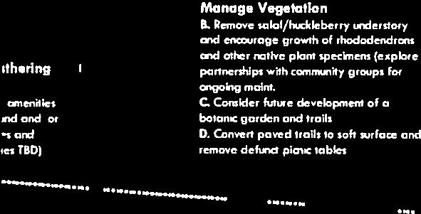
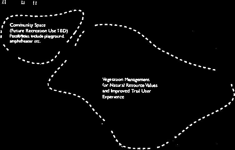
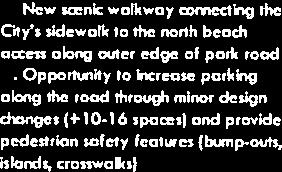
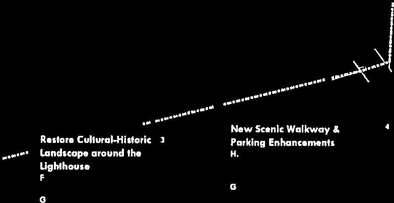
12 Bicycle/Pedestrian Advisory Committee Agenda Item Report Agenda Item No Submitted by: Peggy Hawker Submitting Department: City Manager s Office Meeting Date: October 11, 2016 SUBJECT Agate Beach Historic Trail Recommendation: Discussion. ATTACHMENTS Agate Beach Historic Trail Information.pdf 12


13 13


14 14


15 15


16 16


17 17


18 18

19 19


20 20

21 21

22 22

23 23

24 24


25 25
26 26


27 27


28 28


29 29


30 30


31 31
32 32
33 Bicycle/Pedestrian Advisory Committee Agenda Item Report Agenda Item No Submitted by: Peggy Hawker Submitting Department: City Manager s Office Meeting Date: October 11, 2016 SUBJECT Review and Comment on State Parks Master Plan Update as it Relates to Newport Recommendation: Discussion. ATTACHMENTS Oregon Parks and Recreation Department Master Plan Update.pdf 33


34 34
35 35


36 36
37 37


38 38
39 39


40 40
41 41


42 42
43 43


44 44
45 45

46 46


47 47

48 48


49 49

50 50

51 51


52 52

53 53

54 54

55 55
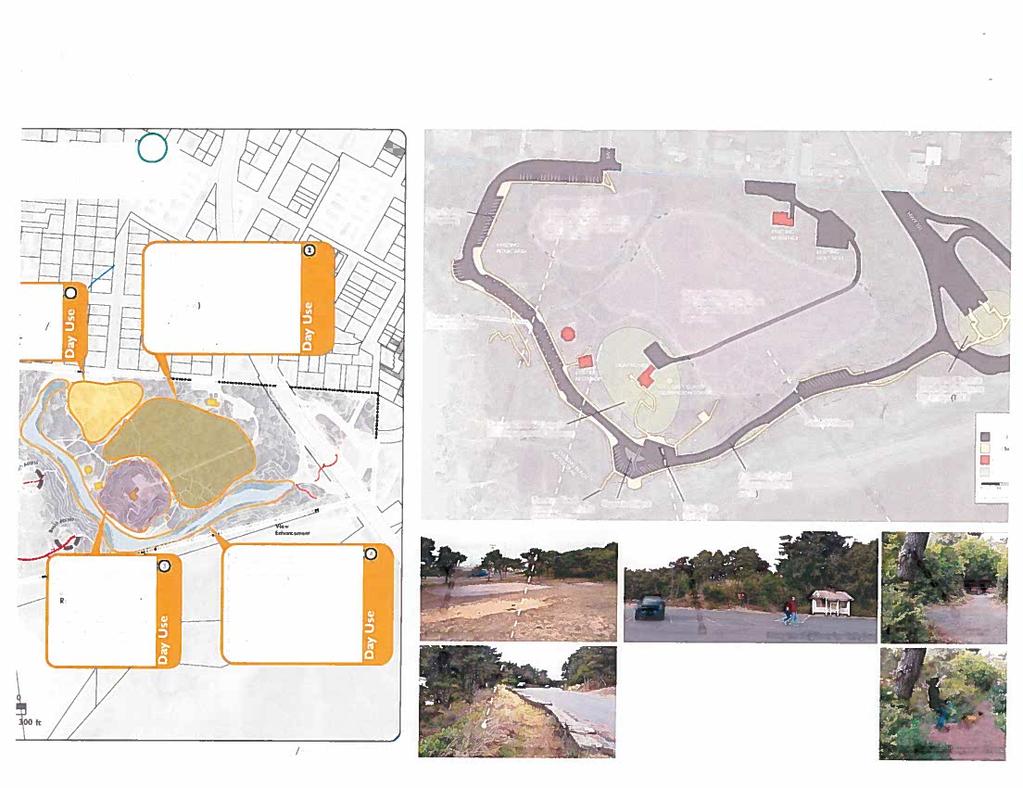
56 Bicycle/Pedestrian Advisory Committee Agenda Item Report Agenda Item No Submitted by: Peggy Hawker Submitting Department: City Manager s Office Meeting Date: October 11, 2016 SUBJECT Review Existing Projects: (1) Trail - NW Nye Street to Oceanview Drive; (2) Trail Connecting Agate Beach Wayside Trail to Sidewalk on Highway 101 West Side; and (3) Sidewalks from the Bayfront to the Hospital Recommendation: Review projects. ATTACHMENTS Agate Beach SP to 101 Trail - Project Summary Memo.docx Concept Plans-Agate Beach SP to 101.pdf Copy of Agate Beach SP to 101 Trail - Concept Cost Estimate.xlsx NW Oceanview to Nye MU Path - Project Summary Memo.docx Concept Plans-NW Oceanview to Nye.pdf Copy of NW Oceanview to Nye MU Path - Concept Cost Estimate.xlsx SW Harbor Way Sidewalk - Project Summary Memo.docx Concept Plans-SW Harbor Way.pdf Copy of SW Harbor Way Sidewalk - Concept Cost Estimate.xlsx 56
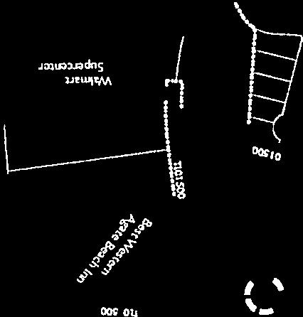
57 MEMO Date: February 3, 2015 To: From: Re: Tim Gross, Public Works Director/City Engineer Olaf Sweetman, Assistant City Engineer Concept cost estimate for Agate Beach State Park to US-101 Trail Connector A Pedestrian/Bicycle Committee priority project is to connect the paved trail in Agate Beach State Park with the sidewalk located between US-101 and Walmart, which currently terminates at the Best Western Plus Agate Beach Inn. This memo presents a proposed project concept and associated cost estimate. First, please refer to the included concept plan. The concept places a 6-foot-wide stairway for the trail connector. Stairs are needed due to steep terrain in this area. The average grade of the trail connector would be 20-25%. The stairway could either be surfaced in concrete or gravel. Concrete is expected to be cost-competitive due to the labor needed to place gravel. The project concept also includes a concrete landing, marked crosswalk, new curb for directing runoff away from the slope, and modification of the existing guardrail. This project would require the permission of ODOT and possibly Oregon State Parks, as it would be located within ODOT right-of-way. Next, please refer to the included cost estimate. For purposes of this cost estimate, I ve made the following assumptions: - No retaining wall would be needed. - Engineering services (survey, design, bidding, construction management) would be provided by the City at no cost to the project. - Existing boundary fencing for the State Park would be modified at negligible cost to the project. - No other cost items would be required by ODOT or Oregon State Parks. 57

58 58
59 Concept Cost Estimate Agate Beach State Park to US-101 Trail Connector Item Unit Est. Quantity Est. Unit Price Total Price Notes Modify Guardrail LF 25 $60.00 $1,500 Striping - new crosswalk EA 1 $ $800 Alternative 1 (Concrete Stairway) Mobilization, Traffic Control, and Erosion Control LS 1 $3, $3,000 Base Aggregate TN 10 $ $4,000 Price is high due to labor 6-foot wide Concrete Stairway SF 900 $10.00 $9,000 Concrete Landing EA 1 $ $800 Concrete Curb LF 35 $30.00 $1,050 Total Est. Cost: + 20% Contingency: Round to nearest $1,000: Official Est. Cost (Concrete): $20,150 $4,030 $24,180 $24,000 Alternative 2 (Gravel Stairway) Mobilization, Traffic Control, and Erosion Control LS 1 $4, $4,000 6-foot wide Gravel Stairway SF 900 $15.00 $13,500 Concrete Landing EA 1 $1, $1,200 Concrete Curb LF 35 $40.00 $1,400 Total Est. Cost: + 20% Contingency: Round to nearest $1,000: Official Est. Cost (Gravel): $22,400 $4,480 $26,880 $27, /5/2016 Page 1 of 1 Estimate by: Olaf Sweetman, Assistant City Engineer
60 MEMO Date: February 3, 2015 To: From: Re: Tim Gross, Public Works Director/City Engineer Olaf Sweetman, Assistant City Engineer Concept cost estimate for NW Oceanview Dr to NW Nye St Multi-use Path A Pedestrian/Bicycle Committee priority project is to connect NW Oceanview Dr to the northern terminus of NW Nye St (a.k.a. NW Pine St), with a multi-use path suitable for bicyclists. This memo presents a proposed project concept and associated cost estimate. First, please refer to the included concept plan. The concept places a 10-foot-wide raised boardwalk as the multi-use path. Raised boardwalk is proposed due to concerns about steep terrain and wetlands. The proposed boardwalk would have a consistent grade of about 10%. This is fairly steep. For comparison, here are approximate grades of selected streets in the SW Bay Blvd area: SW Bay St: 9% SW Naterlin Dr (upper portion): 10% SW Harbor Way (upper portion): 11% SW Hatfield Dr (lower portion): 15% SE Fogarty St (2 nd St to 3 rd St): 20% It appears that the boardwalk could be constructed without removing any large trees, while some smaller trees would be removed. The project would require coordination and permitting with Oregon Dept. of State Lands due to wetlands. Next, please refer to the included cost estimate. For purposes of this cost estimate, I ve made the following assumptions: - Due to International Building Code requirements, the railing is engineered to withstand a 300 lb side load. - Foundation piers are placed every 10', three across. - No cost items would be required by Oregon Dept. of State Lands. 60

61 61
62 Concept Cost Estimate NW Oceanview Dr to NW Nye St Multi-use Path Item Unit Est. Quantity Est. Unit Price Total Price Notes Engineering Surveying LS 1 $3, $3,000 Design & Bidding LS 1 $25, $25,000 Includes Oregon DSL coordination and permitting Construction Services LS 1 $5, $5,000 Construction Mobilization, Traffic Control, and Erosion Control LS 1 $10, $10, foot wide Boardwalk - Decking & Substructure SF 1500 $60.00 $90, foot wide Boardwalk - Railing LF 300 $ $30,000 Foundation (per pier) EA 48 $ $24,000 Concrete Landing EA 2 $2, $4,000 Total Est. Cost: + 30% Contingency: Round to nearest $1,000: Official Est. Cost: $191,000 $57,300 $248,300 $248, /5/2016 Page 1 of 1 Estimate by: Olaf Sweetman, Assistant City Engineer

63 MEMO Date: February 3, 2015 To: From: Re: Tim Gross, Public Works Director/City Engineer Olaf Sweetman, Assistant City Engineer Concept cost estimate for SW Harbor Way Sidewalk and Improvements A Pedestrian/Bicycle Committee priority project is to construct sidewalk along SW Harbor Way, which would connect existing sidewalks at SW 11 th St and SW 13 th St. This memo presents a potential project concept and associated cost estimate. First, please refer to the included concept plan. The concept places new sidewalk on the west side of SW Harbor Way, due to property line encroachment on the east side. It also includes sidewalk at SW 11 th St and SW 13 th St, with ADA ramps and marked crosswalks at both crossings. The concept would also realign the intersection at SW 13 th St. Existing pavement, curb, and sidewalk would be removed for the new alignment. New curb and two catch basins would be constructed, and concrete driveways extended to match the new alignment. Next, please refer to the included cost estimate. For purposes of this cost estimate, I ve made the following assumptions: - The project cost would exceed $50,000, which would trigger BOLI Prevailing Wage Rates. - Two fire hydrants would be relocated by the City at no cost to the project. - There would be no other utility conflicts or they would be resolved at no cost to the project. - No retaining wall would be needed. - Engineering services (survey, design, bidding, construction management) would be provided by the City at no cost to the project. - Soil fill and landscaping behind the new curb at SW 13 th St would be provided by the City at no cost to the project. 63

64 64
65 Concept Cost Estimate SW Harbor Way Sidewalk and Improvements Item Unit Est. Quantity Est. Unit Price Total Price Notes Mobilization, Traffic Control, and Erosion Control LS 1 $6, $6,000 Remove Existing Pavement/Curb/Sidewalk SY 400 $10.00 $4,000 Grading - remove and dispose material CY 200 $30.00 $6,000 Slope behind sidewalk to be cut back Base Aggregate TN 100 $40.00 $4,000 6' wide Concrete Sidewalk SY 500 $40.00 $20,000 ADA Ramp EA 4 $1, $4,800 Concrete Curb LF 350 $25.00 $8,750 Post-type Curb for back of sidewalk LF 200 $20.00 $4,000 Helps retain slope behind sidewalk Concrete Driveway SY 40 $50.00 $2,000 Asphalt Patch SY 50 $40.00 $2,000 Striping - new crosswalk EA 2 $ $1,200 Catch Basin EA 2 $1, $3,000 Storm Main LF 60 $60.00 $3,600 Connect to existing manhole EA 2 $ $1,000 Total Est. Cost: + 10% Contingency: Round to nearest $1,000: Official Est. Cost: $62,750 $6,275 $69,025 $69, /5/2016 Page 1 of 1 Estimate by: Olaf Sweetman, Assistant City Engineer
66 Bicycle/Pedestrian Advisory Committee Agenda Item Report Agenda Item No Submitted by: Peggy Hawker Submitting Department: City Manager s Office Meeting Date: October 11, 2016 SUBJECT Bicycle/Pedestrian Plan Update - Prioritization of Projects - Submit Individual Priortizations for Staff Compilation Recommendation: Submit prioritizations to staff. ATTACHMENTS 66
67 Bicycle/Pedestrian Advisory Committee Agenda Item Report Agenda Item No Submitted by: Peggy Hawker Submitting Department: City Manager s Office Meeting Date: October 11, 2016 SUBJECT Bicycle/Pedestrian Accidents for August and September Recommendation: None. ATTACHMENTS 67
68 Bicycle/Pedestrian Advisory Committee Agenda Item Report Agenda Item No Submitted by: Peggy Hawker Submitting Department: City Manager s Office Meeting Date: October 11, 2016 SUBJECT November 8, 2016 Recommendation: None. ATTACHMENTS 68
BICYCLE AND PEDESTRIAN ADVISORY COMMITTEE AGENDA Tuesday, June 13, :30 PM Conference Room A
 BICYCLE AND PEDESTRIAN ADVISORY COMMITTEE AGENDA Tuesday, June 13, 2017-5:30 PM Conference Room A The meeting location is accessible to persons with disabilities. A request for an interpreter for the hearing
Item No. 14 Town of Atherton
 Item No. 14 Town of Atherton CITY COUNCIL STAFF REPORT CONSENT AGENDA TO: THROUGH: FROM: HONORABLE MAYOR AND CITY COUNCIL GEORGE RODERICKS, CITY MANAGER MICHAEL KASHIWAGI, COMMUNITY SERVICES DIRECTOR MARTY
Trail Feasibility. 1. Introduction FINAL. October What s inside?
 VOLUSIA COUNTY MPO CITY OF PORT ORANGE FINAL Trail Feasibility October 2006 What s inside? 1 Introduction 2 Project Purpose & Scope 3 Physical Inventory & Assessment of Right-of- Way 4 Trail Concept Plan
Mid Rivers Mall Drive Multi-Use Path (Rte. N to MO 364)
") Mid Rivers Mall Drive Multi-Use Path (Rte. N to MO 364) Sponsor St Peters Project No. RB19-000022 Project Type Other TOTAL FUNDING Total County Sponsor Federal $1,177,251.00 $238,179.00 $59,546.00 $879,526.00
Mid Rivers Mall Drive Multi-Use Path (Rte. N to MO 364) Sponsor St Peters Project No. RB19-000022 Project Type Other TOTAL FUNDING Total County Sponsor Federal $1,177,251.00 $238,179.00 $59,546.00 $879,526.00
SAFE SCHOOL WALK ROUTES (SSWR) TASKFORCE ADVISORY COMMITTEE 7 TH MEETING MEETING AGENDA
 TASKFORCE ADVISORY COMMITTEE 7 TH MEETING MEETING AGENDA") SAFE SCHOOL WALK ROUTES (SSWR) TASKFORCE ADVISORY COMMITTEE 7 TH MEETING MEETING AGENDA DATE: MONDAY, 5/22/2017 TIME: 6:00 8:00 P.M. LOCATION: CITY HALL, CONFERENCE ROOM #107 Call to Order/Approval of
SAFE SCHOOL WALK ROUTES (SSWR) TASKFORCE ADVISORY COMMITTEE 7 TH MEETING MEETING AGENDA DATE: MONDAY, 5/22/2017 TIME: 6:00 8:00 P.M. LOCATION: CITY HALL, CONFERENCE ROOM #107 Call to Order/Approval of
City of Hyattsville Transportation Study Project Recommendations Planning Level Cost Estimate
 City of Hyattsville Transportation Study Project Recommendations Planning Level Cost Estimate Project ID Project Category Project Name Qty/Len(Mi) Cost Estimate BB 1 Bike boulevard Jefferson Street or
MAG Town of Cave Creek Bike Study Task 6 Executive Summary and Regional Significance Report
 Page 1 MAG Town of Cave Creek Bike Study Task 6 Executive Summary and Regional Significance Report August 1, 2012 MAG Project #481 Page 2 Task 6 Executive Summary and Regional Significance Report Introduction
Safe Routes to School Action Plan Aberdeen, Idaho
 Background Aberdeen, Idaho is a largely agricultural community of nearly 2,000 people and is located in the southeast portion of the state on the western edge of American Falls Reservoir. The community
APPENDIX A: Complete Streets Checklist DRAFT NOVEMBER 2016
 APPENDIX A: Complete Streets Checklist DRAFT NOVEMBER 2016 Complete Streets Checklist MetroPlan Orlando s Complete Streets Checklist is an internal planning tool for staff to further implementation of
WHEREAS delivery trucks also pass through the Narrows, into the northern parking lot, to loading docks in the back of the building.
 CEDAR-ISLES-DEAN NEIGHBORHOOD ASSOCIATION ( CIDNA ) RESOLUTION OPPOSING A DRUG STORE DRIVE THRU, AND COMMENDING DORAN COMPANIES FOR PROPOSING MITIGATING AMENITIES INCLUDING NEW LANDSCAPING AND A DEDICATED
CTH M HIGHWAY PROJECT CTH Q to STH 113
 CTH M HIGHWAY PROJECT CTH Q to STH 113 PUBLIC INFORMATIONAL MEETING #3 Wednesday, May 25, 2005 Town of Westport Administration Building 5387 Mary Lake Road 6:00 p.m. to 8:00 p.m. PUBLIC INFORMATIONAL MEETING
City of Roseville Section 13 Design Standards. _Bikeways January 2016 SECTION 13 BIKEWAYS
 SECTION 13 BIKEWAYS 13-1 GENERAL The City of Roseville bikeway standards are designed to insure that transportation and recreational bikeways are constructed in a manner that would provide a safe and comfortable
Duwamish Way-finding and CTR Report
 V. North Tukwila When the North Tukwila Manufacturing and Industrial Center was designated in 1992 as part of the region s land use and transportation plan, the plan called for the area to set a light-rail
SR-203 Sidewalks and Town-Wide Mobility Improvements. Town Council Presentation September 7, 2016
 SR-203 Sidewalks and Town-Wide Mobility Improvements Town Council Presentation September 7, 2016 SR-203 Sidewalks and Town- Wide Mobility Improvements SR-203 Sidewalks and Appurtenances Town-Wide Mobility
Poor pavement condition Substandard Intersections. / Substandard bike/pedestrian/transit accommodations. Driveway access Environmental concerns
 Public Informational Meeting University Avenue (Allen Boulevard Segoe Road) March 23, 2011 City of Madison City of Middleton Village of Shorewood Hills Dane County Existing Roadway Conditions Poor pavement
ACTION TRANSMITTAL No
 Transportation Advisory Board of the Metropolitan Council of the Twin Cities DATE: August 25, 2016 TO: FROM: ACTION TRANSMITTAL No. 2016-47 Technical Advisory Committee TAC Funding and Programming Committee
CITY OF KASSON TRANSPORTATION ALTERNATIVES KASSON SAFE ROUTES TO SCHOOL
 ve ha 8t G B A Mantorville Ave N 240th Ave 16th St NE 11th Ave NE K-M HIGH SCHOOL SUNRISE TRAIL TO MANTORVILLE MNTH 57 SUNSET TRAIL TO MANTORVILLE NE PARK 16TH ST NE TRAIL K-M ELEMENTARY SCHOOL K-M MIDDLE
Complete Streets Funding Program Project Prioritization Plan
 Funding Program Project Prioritization Plan Location and Type Needs South Street Crosswalk Installation Stripe a new formalized crosswalk across South Street at the Anne T. Dunphy School pedestrian path
Knox Street Complete Streets Project
 Knox Street Complete Streets Project Meeting Purpose Get community feedback on two conceptual street design options Meeting Agenda Presentation (20 minutes) Project background and schedule Summary of preferences
Click to edit Master title style
 Click to edit Master title style Public Information Meeting August 2, 2018 Town of Rotterdam Transportation Alternatives Program Main St (NYS 5S) Pedestrian/Bicycle Access Improvement Project Agenda TAP
Ocean Park Boulevard Green Street Project Community Workshop
 Ocean Park Boulevard Green Street Project Community Workshop 2.2.10 Project Objectives Community Priority: reclaim OPB for public open space. Build upon LUCE principles; neighborhood enhancement, connectivity,
DISTRICT BICYCLE PROGRAM
 DISTRICT BICYCLE PROGRAM TxDOT Fort Worth District Public Hearing Bicycle Use on the State Highway System Public Hearing Agenda 1 2 3 4 5 6 Introduction Susan Howard TxDOT Public Involvement Specialist
Bicycle and Pedestrian Facilities Toolbox (Excerpt from Figure 3.1)
") Appendix B Neighborhood Connections Summaries This Appendix is a supplement to the information presented in Chapter 3 Connect People. The Appendix includes a summary or profile for each of the proposed
Appendix B Neighborhood Connections Summaries This Appendix is a supplement to the information presented in Chapter 3 Connect People. The Appendix includes a summary or profile for each of the proposed
TRANSPORTATION ALTERNATIVES PROGRAM: SELECTED PROJECTS AND FUNDING ALLOCATIONS
 ITEM #9: TRANSPORTATION ALTERNATIVES PROGRAM: SELECTED PROJECTS AND FUNDING ALLOCATIONS The Transportation Alternatives Program (TAP) created by MAP-21 requires that 50% of the program funds received by
Lee s Summit Road Improvement Study Public Open House June 7, 2007 Summary of Comment Card Responses
 Lee s Summit Road Improvement Study Public Open House June 7, 2007 Summary of Comment Card Responses Introduction At the Lee s Summit Road Improvement Study Public Open House held Thursday, June 7, 2007
CHAPTER 16 PEDESTRIAN FACILITIES DESIGN AND TECHNICAL CRITERIA TABLE OF CONTENTS
 CHAPTER 16 PEDESTRIAN FACILITIES DESIGN AND TECHNICAL CRITERIA TABLE OF CONTENTS Section Title Page 16.1 General... 16-1 16.1.1 AASHTO Reference... 16-1 16.1.2 ADA Requirements... 16-1 16.2 Sidewalks...
Rolling Out New Bike Facilities Within the North Bethesda & White Flint Area
 Rolling Out New Bike Facilities Within the North Bethesda & White Flint Area Rolling Out New Bike Facilities Within the North Bethesda & White Flint Area Agenda Designing for all Cyclists Background on
FY 2016 TRANSPORTATION ALTERNATIVES PROGRAM PROJECT SELECTION
 AGENDA ITEM #8: FY 2016 TRANSPORTATION ALTERNATIVES PROGRAM PROJECT SELECTION The Transportation Alternatives Program (TAP) created by MAP-21 requires that 50% of the program funds received by the state
Brooklyn Boulevard (County Road 152) Reconstruction Project Phase I. OPEN HOUSE June 20, 2017
 Reconstruction Project Phase I. OPEN HOUSE June 20, 2017") Brooklyn Boulevard (County Road 152) Reconstruction Project Phase I OPEN HOUSE June 20, 2017 Brooklyn Boulevard (County Road 152) Phase I Project Partners Project Lead Other Project Partners include Brooklyn
Brooklyn Boulevard (County Road 152) Reconstruction Project Phase I OPEN HOUSE June 20, 2017 Brooklyn Boulevard (County Road 152) Phase I Project Partners Project Lead Other Project Partners include Brooklyn
West Circle Drive (CSAH 22) Traffic Operations Study
 Traffic Operations Study") West Circle Drive (CSAH 22) Traffic Operations Study May 24, 2016 Open House Harriet Bishop Elementary School 6:45 8:00 p.m. Presentation at 7:00 p.m. Purpose of Tonight s Meeting Introductions Explain
West Circle Drive (CSAH 22) Traffic Operations Study May 24, 2016 Open House Harriet Bishop Elementary School 6:45 8:00 p.m. Presentation at 7:00 p.m. Purpose of Tonight s Meeting Introductions Explain
Final Sidewalk Feasibility Study
 Garfield Drive From Anastasia Drive to Elizabeth Place City of South Daytona July 23, 2009 Final Sidewalk Feasibility Study Prepared for: Prepared by: Final Sidewalk Feasibility Study Garfield Drive 2
NJDOT Complete Streets Checklist
 Background The New Jersey Department of Transportation s Complete Streets Policy promotes a comprehensive, integrated, connected multi-modal network by providing connections to bicycling and walking trip
West End Connectivity Master Plan
 West End Connectivity Master Plan Office of Commissioner Juan C. Zapata District 11 Page 1 of 13 Juan C. Zapata MIAMI- DADE COUNTY COMMISSIONER Introduction I am pleased to announce the West End Connectivity
Meeting Summary. St. Helens US 30 & Columbia Blvd./St. Helens St. Corridor Master Plan Technical Advisory Committee Meeting #2
 Meeting Summary St. Helens US 30 & Columbia Blvd./St. Helens St. Corridor Master Plan Technical Advisory Committee Meeting #2 March 17, 2014 1:15 3:15 pm St. Helens City Hall 1. Introductions and Meeting
City of Madison, East Johnson Street North Baldwin Street to First Street Local Street Dane County
 City of Madison, East Johnson Street North Baldwin Street to First Street Local Street Dane County Public Involvement Meeting Thursday, April 28, 2016 6 to 8 P.M. Lapham Elementary School 1045 E. Dayton
East Downtown Tax Increment Reinvestment Zone (TIRZ) No. 15 Infrastructure Assessment Study
 No. 15 Infrastructure Assessment Study") East Downtown Tax Increment Reinvestment Zone (TIRZ) No. 15 Infrastructure Assessment Study Houston, TX Technical Memorandum April 15 th, 2009 Prepare by: 2950 North Loop West, Ste. 900 Houston, TX 77092
East Downtown Tax Increment Reinvestment Zone (TIRZ) No. 15 Infrastructure Assessment Study Houston, TX Technical Memorandum April 15 th, 2009 Prepare by: 2950 North Loop West, Ste. 900 Houston, TX 77092
City of Madison, East Johnson Street North Baldwin Street to First Street Local Street Dane County
 City of Madison, East Johnson Street North Baldwin Street to First Street Local Street Dane County Public Involvement Meeting Thursday, November 10, 2016 5:30 to 7 P.M. Festival Foods 810 E. Washington
Sandwich Pedestrian/Bicycle Planning
 Sandwich Pedestrian/Bicycle Planning Improved Pedestrian and Bicycle Connections with the Cape Cod Canal Multi-use Path February 2014 Table of Contents Introduction... 1 Background... 1 Study Goals...
RZC Appendix 8A Marymoor Subarea Street Requirements
 RZC Appendix 8A Marymoor Subarea Street Requirements For additional design details for Marymoor Subarea infrastructure, refer to the 2017 Marymoor Subarea Infrastructure Planning Report. STREET REQUIREMENTS
Bicycle and Pedestrian Connectivity Study. Old Colony Planning Council
 Bicycle and Pedestrian Connectivity Study Old Colony Planning Council Outline Why consider bike/peds in road designs? Why are measures needed? Connecting Land Use with Transportation Evaluation Tools:
St. Francis Drive through the City of Santa Fe Corridor Study
 VII. ENGINEERING AND ENVIRONMENTAL EVALUATION TRAIL CONNECTIVITY In the southern portion of the Corridor there is a lack of a sidewalk, trail or bicycle facility within the right-ofway. However, the City
Appendix D: Planning Level Cost Calculator
 Appendix D: Planning Level Cost Calculator Network Costs by Facility Type Facility Type Total Miles of Facility Total Number of Intersections Cost per feature or per mile Total Cost Bicycle Boulevard 52.14
BICYCLE AND TRAILS ADVISORY COMMISSION Meeting Minutes
 Minutes Approved as Submitted Date: 8/10/17 Initials: EC BICYCLE AND TRAILS ADVISORY COMMISSION Meeting Minutes June 8, 2017 The Bicycle and Trails Advisory Commission was called to order at 4:00 p.m.
4APNOIPF Vh, YII PTC CITY COUNCIL AGENDA REPORT. Honorable Mayor and City Council Members. 8K TH 63 River Crossing Bridge Replacement Project
 City of RE 4APNOIPF Vh, X` W\ YII PTC ING, CITY COUNCIL AGENDA REPORT Council Meeting Date: September 26, 2016 To: From: Agenda Item: Honorable Mayor and City Council Members Ron Rosenthal, Engineering
Americans with Disabilities Act Transition Plan for Public Right-of-Way Improvements
 Americans with Disabilities Act Transition Plan for Public Right-of-Way Improvements Prepared by: Public Works Department Engineering Division October 2015 Table of Contents Section I Introduction.. 3
DRAFT. System Components. Greenway Trails. Introduction. Trail Types. Zebulon Greenway Master Plan
 5 System Components Wakefield Street Photo Simulation showing Sharrows Introduction The Master Plan identifies various system components that, together, create a comprehensive greenway system. These components
Blue Ribbon Commission Report Recommendations on Pedestrian and Bicycle Infrastructure Improvements
 Recommendations on Pedestrian and Bicycle Infrastructure Improvements July 2017 Plan Development: Our committee consisted of seven individuals appointed by the Mayor and Village Board. Those members included:
Montgomery County Life Sciences Center Loop Trail
 Montgomery County Life Sciences Center Loop Trail Advisory Committee Meeting #1 February 10, 2015 Agenda 1. Project Background 2. Existing Conditions Analysis 3. Examples from Elsewhere 4. Discussion Project
Chapter 4: Funding and Implementation
 Chapter 4: Funding and Implementation 83 84 Cost Estimating Cost estimating is an iterative process. When a project is in the conceptual stage, preliminary cost estimates are also provided conceptually,
NM-POLICY 1: Improve service levels, participation, and options for non-motorized transportation modes throughout the County.
 Transportation PRINCE WILLIAM COUNTY 2008 COMPREHENSIVE PLAN NON-MOTORIZED PLAN CONTENTS Goals, Policies, and Action Strategies Table 4 (Bike Facility Classifications and Descriptions) Table 5 (Bike Facility
DRAFT. Scholls Ferry Road Conceptual Design Plan Technical Memorandum Multi-Modal Examples. Multnomah County 1600 SE 190th Avenue Portland, OR 97233
 Technical Memorandum Multi-Modal Examples Prepared for 1600 SE 190th Avenue Portland, OR 97233 December 2008 CITATION This project is partially funded by a grant from the Transportation and Growth Management
CORE MPO Non-motorized Transportation Plan. Appendix F. Technical Report on Cost Estimation Methodology
 Appendix F Technical Report on Cost Estimation Methodology This page is intentionally left blank. Technical Report on Cost Estimation Methodology The total costs of the projects in the Non-motorized Transportation
CITY OF SLO SEEKS INPUT ON PREFERRED ALTERNATIVE FOR BROAD STREET BICYCLE BOULEVARD PROJECT
 City of San Luis Obispo, News Release DATE: August 1, 2017 RELEASE: Immediate CONTACT: Luke Schwartz (805) 781-7190 Transportation Planner-Engineer, Public Works CITY OF SLO SEEKS INPUT ON PREFERRED ALTERNATIVE
Pavement Management Report. City Council Meeting of May 21, 2013
 Pavement Management Report City Council Meeting of May 21, 2013 Previous Meetings Summary In February, we presented the 2012 pavement survey and our consultant presented general pavement management strategies
North Avenue Rail Station Accessibility Assessment
 North Avenue Rail Station Accessibility Assessment Joel Anders, Arnaud Huguet, and Alex Poznanski 30 July 2012 Table of Contents EXECUTIVE SUMMARY... 1 MISSION STATEMENT... 2 INTRODUCTION... 2 CROSSWALKS
Active Transportation Rail to River Corridor. Community Meeting - Segment A
 Active Transportation Rail to River Corridor Community Meeting - Segment A June 29, 2017 Tonight s Agenda > Open House (30 min) > Welcome / Project Overview > Presentation of 30% Design Refinements > Next
AGENDA ITEM SUMMARY SPECIAL AGENDA ITEM NO. _1A_
 AGENDA ITEM SUMMARY AGENCY: City Council MEETING DATE: June 25, 2012 DEPARTMENT: Community Dev PREPARED BY: T Spade DEPT. DIR. APPROVAL: MJ CITY MGR. APPROVAL: LR PRESENTED BY: T Spade TITLE: RECEIVE REPORT
Legislative Update Williamsburg Residency
 Hampton Roads District Legislative Update Williamsburg Residency Jim Brewer, Resident Administrator 757-253-5140 Projects Under Way Warwick Boulevard Project http://www.warwickboulevard.org/ Contractors:
SRTS IMPLEMENTATION COSTS
 SRTS IMPLEMENTATION COSTS What Is a Estimate? A cost estimate establishes the anticipated budget required to implement the actions (the improvement projects and programs) identified in your School Travel
Building Great Neighbourhoods BELLEVUE AND VIRGINIA PARK
 Building Great Neighbourhoods BELLEVUE AND VIRGINIA PARK This is Meeting 2 Unfortunately, some residents in Bellevue and Virginia Park received the wrong information for this public open house (Meeting
Agenda. Overview PRINCE GEORGE S PLAZA METRO AREA PEDESTRIAN PLAN
 PRINCE GEORGE S PLAZA METRO AREA PEDESTRIAN PLAN May 28, 2008 Agenda Welcome and introductions Project overview and issue identification Planning context and strengths Design challenges and initial recommendations
Minutes of the regular meeting of the City of Birmingham Multi-Modal Transportation Board held June 19, 2014.
 CITY OF BIRMINGHAM START-UP MEETING OF THE MULTI-MODAL TRANSPORTATION BOARD THURSDAY, JUNE 19, 2014 City Commission Room 151 Martin Street, Birmingham, Michigan Minutes of the regular meeting of the City
Ocean Park Boulevard Green Street Project Alternatives & Trade Offs
 Planning Commission March 4, 2009 Ocean Park Boulevard Green Street Project Alternatives & Trade Offs Purpose of Tonight s Meeting Review concept plans and options Provide input on alternatives and trade-offs
Pine Hills Road Pedestrian/Bicycle Safety Study Board of County Commissioners Work Session
 Pine Hills Road Pedestrian/Bicycle Safety Study Board of County Commissioners Work Session February 20, 2018 Meeting Agenda Study Overview Existing Conditions Access Management Potential Gateway Features
IMPLEMENTATION WORKBOOK
 Lawrence Township Bicycle and Pedestrian Planning Assistance Study IMPLEMENTATION WORKBOOK Final Action Plan - Part 2 April 2009 Prepared For: The Township of Lawrence and the New Jersey Department of
West Dimond Blvd Upgrade Jodhpur Street to Sand Lake Road
 West Dimond Blvd Jodhpur St to Sand Lake CSS Transportation Project Summary Municipality of Anchorage Project # 05 005 Project Manager: John Smith, P.E. (MOA PM&E) Project Administrator: Julie Makela,
Board of Supervisors February 27, 2017
 : Traffic Analysis Results & Draft Conceptual Plan Board of Supervisors February 27, 2017 Transportation Solutions Building Better Communities Presentation Overview Background Summary of Traffic Analysis
APPENDIX G: INTERSECTION NEEDS AT OKEECHOBEE BOULEVARD
 APPENDIX G: INTERSECTION NEEDS AT OKEECHOBEE BOULEVARD INTERSECTION NEEDS AT SR 7 and OKEECHOBEE BOULEVARD SR 7 Extension Project Development and Environment (PD&E) Study From Okeechobee Boulevard (SR
City of Sammamish. Welcome. Issaquah-Fall City Road Improvements Project Phase I Design: 242nd Avenue SE to Klahanie Drive SE
 Welcome Welcome to the third community meeting for the Issaquah-Fall City Road Improvements Project. AGENDA 6:00 p.m. Welcome and sign-in 6:10 p.m. Presentation 6:50 p.m. Open house Learn about the roadway
Hospital Link Project Project Update September 2017
 Hospital Link Project Project Update September 2017 General The project provides a link from Riverside Drive and the Transitway to the Hospital Link Road. Construction is well underway. Read on for important
Land Use Bicycle Spaces Required Type Residential
 SAMPLE ORDINANCES AND RESOLUTIONS APPENDIX B SAMPLE BICYCLE PARKING ORDINANCE Land Use Bicycle Spaces Required Type Residential Single Family/Two Family N/A N/A Apartment/Townhome 1 per unit plus 6 space
Parking. Parking 11/27/2012. On street parking. Off-street parking is space provided for vehicular parking outside the dedicated street right-of-way.
 Parking On street parking Off-street parking is space provided for vehicular parking outside the dedicated street right-of-way. At-grade parking lot Parking garages SITE Parking 90 degree (20 x 9 stalls)
TOWN OF MORAGA MORAGA WAY AND CAMINO PABLO/CANYON ROAD IMPROVEMENTS Town Council Meeting March 13, 2019
 TOWN OF MORAGA MORAGA WAY AND CAMINO PABLO/CANYON ROAD IMPROVEMENTS Town Council Meeting March 13, 2019 1 Edric Kwan, Public Works Director Josh Peterman, Principal, Fehr and Peers Shawn Knapp, Senior
ADA TRANSITION PLAN 2013
 ADA TRANSITION PLAN 2013 TABLE OF CONTENTS Contents Introduction 1 Purpose 2 Identified Obstacles to the Public Right of Way 3 Criteria for Determining Impediments at Village Facilities 4 Removing Barriers
Public Open House #2. THE CITY OF NORTH VANCOUVER CHESTERFIELD AVENUE CYCLING IMPROVEMENTS (4th - 13th STREET) JULY 2013
 JULY 2013") CHESTERFIELD AVENUE CYCLING IMPROVEMENTS (4th - 13th Street) Public Open House #2 1 Chesterfield Avenue provides an important north/south connection between Lonsdale Quay and West 23rd Street Purpose of
CHESTERFIELD AVENUE CYCLING IMPROVEMENTS (4th - 13th Street) Public Open House #2 1 Chesterfield Avenue provides an important north/south connection between Lonsdale Quay and West 23rd Street Purpose of
Pedestrian, Bicycle and Traffic Calming Strategic Implementation Plan. January 18, 2011
 Pedestrian, Bicycle and Traffic Calming Strategic Implementation Plan January 18, 2011 Tonight s Agenda Receive update on project Provide feedback on two policy issues Complete Streets Policy Project Prioritization
Accommodating Pedestrians in the Work Zone
 Accommodating Pedestrians in the Work Zone Guidance for Section C Plan Preparers Some impacts cannot be avoided and those impacts apply to residents, businesses, motorists, and pedestrians alike. However,
Ocean Park Boulevard Streetscape Improvement Project Alternatives & Trade Offs
 City Council Study Session January 27, 2009 Ocean Park Boulevard Streetscape Improvement Project Alternatives & Trade Offs Scope of Work Purpose of Tonight s Meeting Review work to date and direct staff
and older adults and people with disabilities still face barriers when using the pedestrian network and public transportation.
 Background Afterthe1980Olympics,theLakePlacid/NorthElbacommunityadoptedaneconomicstrategy ofdevelopingandmarketingeventstoincreaseareatourism.thisstrategyhasbeenvery successful.overrecentyearsthevolumeofvisitorshasincreased,andthelengthofthe
Lawrence Loop SWOT Analysis
 Alignment: A1 (Map Color: Red) Description: This alignment connects to the Sandra Shaw Trail on the north side of the pond and heads north through undeveloped property and then west to Michigan Street
What Is a Complete Street?
 Session 5 Charleen Zimmer, AICP, Zan Associates May 5-7, 2010 What Is a Complete Street? May 2010 5-1 Not a Complete Street More of a Complete Street May 2010 5-2 Benefits of Complete Streets Safety for
City of Gainesville Transportation/Roadway Needs PROJECT SUMMARY
 A1 Roadway Resurfacing $23,846,000 TYPE: Preservation of existing system Roadway resurfacing A2 Signal Replacement $6,000,000 TYPE: Preservation of existing system Replace traffic signals. B1 W 6th St
HARRISON STREET/OAKLAND AVENUE COMMUNITY TRANSPORTATION PLAN
 HARRISON STREET/OAKLAND AVENUE Community Workshop #4: Draft Plan Review December 3, 2009 D E S I G N, C O M M U N I T Y & E N V I R O N M E N T INTRODUCTIONS Key Project Staff: Alisa Shen, Project Manager,
Northside School Class I Bike Path, Cool, CA Application Attachments
 PLHD Grant Application, 12/9/2011 County of El Dorado Department of Transportation Northside School Class I Bike Path, Cool, CA Application Attachments 1. Project Site Map 2. Auburn State Recreation Area
SECTION 3 STREET DESIGN
 3.01 GENERAL SECTION 3 STREET DESIGN For purposes of geometric and structural design, streets shall be classified according to the following table. The City Engineer will determine the class of all proposed
SD Highway 50 in Yankton (4 TH Street) Reconstruction Project NH 0050(99)381 PCN By Josh Larson McLaury Engineering Inc.
 Reconstruction Project NH 0050(99)381 PCN By Josh Larson McLaury Engineering Inc.") SD Highway 50 in Yankton (4 TH Street) Reconstruction Project NH 0050(99)381 PCN 6926 By Josh Larson McLaury Engineering Inc. Project Limits SD 50 from Broadway to Burleigh and from Marne Creek to Archery
SD Highway 50 in Yankton (4 TH Street) Reconstruction Project NH 0050(99)381 PCN 6926 By Josh Larson McLaury Engineering Inc. Project Limits SD 50 from Broadway to Burleigh and from Marne Creek to Archery
Pedestrian and Bicycle Plan
 Pedestrian and Bicycle Plan DRAFT JULY October 2007 2008 FUNDING ACKNOWLEDGEMENTS The Newport Pedestrian and Bicycle Plan was partially funded by a grant from the Transportation and Growth Management (TGM)
CONNECTIVITY PLAN. Adopted December 5, 2017 City of Virginia Beach
 CONNECTIVITY PLAN Adopted December 5, 2017 City of Virginia Beach CONTENTS 1.0 Background & Purpose... 2 2.0 Existing Inventory & Analysis... 3 ViBe District Existing Walking Conditions... 4 3.0 ViBe District
Span-Wire Intersections Study SPAN-WIRE INTERSECTIONS STUDY. City of Naples Streets & Stormwater Department 1
 SPAN-WIRE INTERSECTIONS STUDY City of Naples Streets & Stormwater Department 1 Intersection Traffic Control and Design Feasibility Analysis a.k.a Span-Wire Intersections Study Streets & Stormwater Department
CITY OF ALBANY TRAFFIC AND SAFETY COMMISSION
 CITY OF ALBANY TRAFFIC AND SAFETY COMMISSION City Hall - Council Chambers 1000 San Pablo Avenue, Albany, CA 94706 Wednesday, November 30, 2016, 7:00 PM 1. CALL TO ORDER The meeting was called to order
Atwood Avenue Fair Oaks Avenue Cottage Grove Road
 Atwood Avenue Fair Oaks Avenue Cottage Grove Road Agenda Purpose Review project scope & goals Present design alternatives Gather feedback Answer Questions Format Open House Presentation Q&A Open House
Basalt Creek Transportation Refinement Plan Recommendations
 Basalt Creek Transportation Refinement Plan Recommendations Introduction The Basalt Creek transportation planning effort analyzed future transportation conditions and evaluated alternative strategies for
July 5, Arthur R. Ware, Jr. Elementary School 2017 Safe Routes to School Walkabout Report
 July 5, 2017 Arthur R. Ware, Jr. Elementary School 2017 Safe Routes to School Walkabout Report 1 Walkabout Report Introduction On April 28, 2017, City, School, and SAWMPO staff met to conduct a Safe Routes
14 TH STREET TRANSPORTATION & STREETSCAPE DESIGN STUDY PLAN B PLAN B TRANSPORTATION & STREETSCAPE RECOMMENDATIONS
 14 TH STREET TRANSPORTATION & STREETSCAPE DESIGN STUDY PLAN B PLAN B TRANSPORTATION & STREETSCAPE RECOMMENDATIONS 141 Symbols Recommendations - Southern End of 14th Street Study Area Streetscape Each icon
Living Streets Policy
 Living Streets Policy Introduction Living streets balance the needs of motorists, bicyclists, pedestrians and transit riders in ways that promote safety and convenience, enhance community identity, create
City of Madison: 2017 Capital Budget Capital Improvement Plan
 Capital Improvement Plan Project Summary Bikeways Program 779,000 751,000 630,000 670,000 703,000 703,000 Cannonball Path 210,000 - - 730,000 - - Cap City Trail 1,140,000-360,000 - - 910,000 Ice Age Junction
ADA on Construction. Guidance for Section C Plan Preparers
 ADA on Construction Guidance for Section C Plan Preparers Some impacts cannot be avoided and those impacts apply to residents, businesses, motorists, and pedestrians alike. However, good planning can minimize
Project Overview. Rolling Road Widening Fairfax County. Get Involved. Design Public Hearing. Contact Information
 Get Involved VDOT representatives will review and evaluate information received as a result of this meeting. Please fill out the comment sheet provided in this brochure if you have any comments or questions.
Shared Use Facili es. Mul -Use Trails. Chapter 3 Design Elements BICYCLE/PEDESTRIAN MULTI USE TRAILS
 Shared Use Facili es "Shared Use" or "Mul -Use" facili es are those where bicyclists share a facility with pedestrians and other non-motorized modes of travel such as equestrians, cross country skiers,
2018 Pedestrian and Bicycle and Safe Routes to School Application for Funding Page 1 of 31
 2018 Pedestrian and Bicycle and Safe Routes to School Application for Funding Page 1 of 31 2018 Pedestrian and Bicycle and Safe Routes to School Application for Funding Part 1: General Information Funding