Roadway Network Development Plan FINAL
|
|
|
- Benjamin Sparks
- 5 years ago
- Views:
Transcription


1 Monroe Township Bicycle and Pedestrian Planning Study Roadway Network Development Plan FINAL March 2010 Prepared For: The Township of Monroe and The New Jersey Department of Transportation Prepared by: Michael Baker, Jr., Inc.
2 i TABLE OF CONTENTS I. INTRODUCTION.. 1 II. STUDY AREA. 2 III. ROADWAY NETWORK RESOURCES.. 4 A. Traffic Volumes. 4 B. Bicycle and Pedestrian Crashes.. 6 C. Sidewalk Survey. 9 D. Bicycle Compatibility. 14 E. Intersections IV. IMPLEMENTATION GUIDE.. 27 A. North Business District Pedestrian Improvements.. 30 B. Community Center Connections C. Texas Road and Matchaponix Road Community Links 37 D. Barclay Brook and Brookside Schools Walking Route. 44 E. Thompson Park Shared Use Path.. 48 F. County Route 615, Union Valley Road, Share the Road 52 G. County Route 614 Sidewalk Improvements.. 57 V. FUNDING THE IMPROVEMENTS. 60 A. Funding Sources 60 B. Safe Routes to School.. 60 VI. MAINTENANCE, EDUCATION AND ENFORCEMENT.. 61 A. Roadway Maintenance 61 B. Education C. Enforcement.. 62 VII. CONCLUSIONS.. 63
3 ii FIGURES Figure 1: Figure 2: Figures 3 8: Figure 9: Figures 10 14: Figure 15: Corridors and Areas Investigated Bicycle and Pedestrian Crash Map Sidewalk Survey Results Bicycle Compatibility Map Intersection Inventory and Assessment Results Proposed Roadway Network Improvements TABLES Table 1: Table 2: Table 3: Table 4: Traffic Volumes for Township Roadways Sidewalk Inventory Results Monroe Township Bicycle Compatibility Matrix Bicycle Compatibility Matrix for Additional Identified Roadways APPENDICES Appendix A: Appendix B: Appendix C: NJDOT Cost Estimating Spreadsheets NJDOT Funding Pedestrian and Bicycle Planning, Programs and Projects Transportation Enhancements


4 1 I. INTRODUCTION Monroe is a township rich in history, recreation and agriculture. Founded in 1838, the township was named in honor of President James Monroe and for a century remained largely a farming community. As portions of the township grew into more defined neighborhoods, they seceded (e.g., Jamesburg). In the past several decades, residential and retail development has patterned the landscape, and many age-restricted communities and services call Monroe home. According to the 2000 Census, nearly half (44%) of the township s population was 65 years of age or older. 1 Monroe s transportation network includes major north/south and east/west county roadway corridors, NJ Transit bus and shuttle bus services, a park-and-ride facility and recreational trails. State Route 33 bisects the southern portion of the township, while the NJ Turnpike traverses the township to the west. Monroe does not have designated on-road bicycle facilities and while sidewalk is being constructed adjacent to new development, there are sidewalk network gaps in areas that are active pedestrian zones. 1 History and demographic data was obtained from the following resources: and

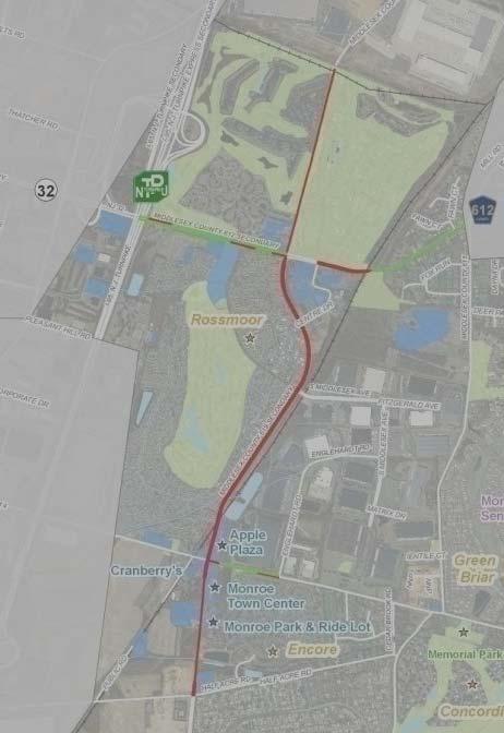
5 2 This document, The Roadway Network Improvement Guide, accompanies the Trail Network Development Plan and together they serve as a planning, and implementation resource for bicycle and pedestrian opportunities in the township. This document focuses on existing data and conditions as related to the roadway network, and recommends improvements to enhance bicycle and pedestrian mobility and access. II. STUDY AREA Specific areas of investigation for the roadway network analysis included: 1) Key corridors and roadways with the potential to provide bicycle and pedestrian connections to major generators, attractors and destinations, including schools, commercial developments, recreational areas and parks, and residential developments. 2) Specific intersections, or areas, where pedestrian and bicycle safety and/or mobility were identified as a concern by local officials, through field investigation, and/or through a review of bicycle and pedestrian crash data. Figure 1 illustrates the corridors, intersections and areas investigated. Resident reviewing the existing trails map at Public Information Center #1

6 3 Figure 1. Corridors and Areas Investigated
7 4 III. ROADWAY NETWORK RESOURCES Data collection was performed to obtain existing resources related to bicycle and pedestrian facilities. Data and documents were obtained from Monroe Township, the Central Jersey Transportation Forum, Middlesex County, the North Jersey Transportation Planning Authority (NJTPA) and the State of New Jersey. Traffic volumes, bicycle and pedestrian crash data, GIS data, NJDOT Straight Line Diagrams and available plans and mapping were requested and received. To supplement data from public agencies, an inventory of sidewalk, roadway attributes (for bicycle compatibility) and pedestrian facilities at identified intersections was performed through several field visits. A summary of existing conditions, as identified through the data collection process, is detailed in this section. A. TRAFFIC VOLUMES Available traffic volumes were collected for roadways in the township. Table 1 lists the collected volumes by roadway. Table 1. Traffic Volumes for Township Roadways Roadway Route 619 (Applegarth Rd.) Route 619 Route 619 Route 619 Limits Centre Dr. and Route 612 (Forsgate Dr.) Route 614 (Prospect Plains Rd.) and S. Middlesex Ave. Blackberry Wy. and Route 614 (Prospect Plains Rd.) Wycoff Mill Rd. and Halsey Reed Rd. AADT (veh./day) 10,000 14,000 12,000 Source So. Midd. Co. Traffic Study So. Midd. Co. Traffic Study So. Midd. Co. Traffic Study Year ,400 NJDOT 2006 Route 619 Route 33 and Bentley Rd. 5,700 NJDOT 2006 Route 522 (Buckelew Ave.) Ralston Wy. and Route 614 (Mounts Mill Rd.) 6,400 NJDOT 2006
8 5 Roadway Butcher Rd. Cranbury Rd. Route 612 Route 612 Jamesburg-Englishtown Rd. Route 619 (Possum Hollow Rd.) Mount Rd. Perrineville Rd. Prospect Plains Rd. Route 33 Route 33 Route 33 Route 613 (Spotswood- Englishtown Rd.) Limits Route 33 and Disbrow Rd. Route 522 (Buckelew Rd.) and Docks Corner Rd. Half Acre Rd. and Centre Dr. Rossmoor Dr. and Monroe Twp. boundary School House Rd. and Spotswood Rd. Route 612 and the railroad tracks England Rd. and Route 619 Route 33 and Mills Rd. Route 619 and Engelghard Rd. Bentley Rd. and Perrineville Rd. Route 619 and Bentley Rd. Mercer County boundary and Route 619 Old Texas Rd. and Cornell Ave. AADT (veh./day) Source Year 4,400 NJDOT ,600 NJDOT ,000 20,000 So. Midd. Co. Traffic Study So. Midd. Co. Traffic Study ,200 NJDOT ,200 So. Midd. Co. Traffic Study NJDOT ,400 NJDOT ,100 NJDOT ,600 NJDOT ,400 NJDOT ,900 NJDOT ,900 NJDOT 2006
9 6 B. BICYCLE AND PEDESTRIAN CRASHES Bicycle and pedestrian crash reports were requested from the NJDOT Bureau of Safety Programs (BSP) and the Monroe Township Police Department for the most recent three (3) years available (2006, 2007 and 2008). The reports were requested to determine the crash history of bicyclists and pedestrians on the township s roadway network. There were eleven (11) reported crashes involving bicyclists or pedestrians between 2006 and Six (6) crashes involved bicyclists and five (5) crashes involved pedestrians. Reported crashes are illustrated in Figure October 01, 2007 (4:19pm) A crash involving a pedestrian and vehicle occurred on Lower Matchaponix Road approximately a 1/2 mile south of Spotswood-Gravel Hill Road. The pedestrian wandered into the roadway and was struck by a vehicle traveling east on Lower Matchaponix Road. The pedestrian was a 1-year old and the crash resulted in a pedestrian fatality. 2. February 13, 2008 (7:09am) A crash involving a pedestrian and a vehicle occurred on Tyndale Avenue approximately 0.2 miles east of Monmouth Road. A pedestrian was walking east along the westbound shoulder of Tyndale Road and was struck by a vehicle traveling westbound, which immediately left the scene. The pedestrian was 40-years old and suffered minor injuries. 3. June 6, 2008 (9:33pm) A crash involving a bicycle and vehicle occurred on Route 527 (Englishtown Road) 100 feet south of Union Valley Road. The bicyclist was traveling south on the roadway and was struck by a vehicle traveling in the same direction, and which immediately left the scene. The bicyclist, who was 24-years old, was severely injured from the crash. 4. July 9, 2008 (10:23pm) A crash involving a pedestrian and a vehicle occurred on Tyndale Avenue approximately a 25 east of Route 613 (Spotswood-Englishtown Road). A pedestrian exited a vehicle and was struck by the door of the vehicle as it pulled away. The pedestrian was 19-years old and suffered minor injuries. 5. July 24, 2008 (11:55am) A crash involving a bicycle and vehicle occurred at the intersection of First Avenue and Route 613. The crash occurred when the vehicle attempted to make a left turn from Route 613 onto First Avenue and then struck the bicyclist who was traveling northbound on Route 613. The bicyclist was 25-years old and suffered minor injuries. 6. August 23, 2008 (11:02pm) A crash involving a pedestrian and two (2) vehicles occurred on Hoffman Station Road approximately a 0.15 miles west of Route 522 (Buckelew Avenue). A vehicle stopped in the eastbound lane of travel on Hoffman Station Road to pick up a passenger and was struck by another vehicle traveling eastbound. The pedestrian was then struck by the vehicle stopped in the travel lane. The pedestrian was 24-years old and suffered minor injuries. 7. September 29, 2008 (6:28pm) A crash involving a bicycle and vehicle occurred at the intersection of Taylor Avenue and Route 613. The vehicle was attempting to make a right
10 7 turn from Route 613 onto Taylor Avenue, and failed to yield, striking the bicyclist who was traveling northbound on Route 613. The bicyclist was 37-years old and suffered minor injuries. 8. September 10, 2008 (10:46am) A crash involving a bicycle and vehicle occurred on Route 619 (Applegarth Road) approximately 1/4 mile south of Lilac Road. The bicyclist was traveling north on Route 619 and was struck by a vehicle traveling in the same direction, which immediately left the scene. The bicyclist was 43-years old and suffered moderate injuries. 9. October 03, 2008 (11:25am) A crash involving a pedestrian and vehicle occurred at the intersection of Route 619 and Cranbury-Half Acre Road. The pedestrian was crossing the intersection with a green light, when a vehicle attempted to turn right onto Route 619 and struck the pedestrian. The age of the pedestrian was not noted and the pedestrian suffered minor injuries as a result of the crash. 10. October 12, 2008 (5:21pm) A crash involving a bicycle and vehicle occurred on Route 619 approximately a 1/4 mile south of Old Church Road. The bicyclist was traveling north on Route 619 and was struck by the side view mirror of a vehicle traveling in the same direction. The bicyclist was 46-years old and suffered moderate injuries. 11. December 14, 2008 (8:07am) A crash involving a bicycle and a vehicle occurred at the intersection of Perrineville Road and Federal Road. The bicyclist and vehicle entered the intersection at the same time, and the bicycle struck the vehicle causing the crash. The bicyclist was 56-years old and suffered moderate injuries.

11 8 Figure 2. Bicycle and Pedestrian Crash Map
12 9 C. SIDEWALK SURVEY The presence and condition of sidewalks were inventoried within a ¼ mile of identified trip generators and attractors to determine where sidewalk network improvements may be needed to enhance pedestrian access and mobility. Additionally, NJDOT County Sidewalk Inventory data was utilized to identify the presence and condition of sidewalk on county routes in the township. Sidewalk conditions were rated based on the following criteria: Excellent Condition: Good Condition: Fair Condition: Poor Condition: Very Poor Condition: Well maintained or new sidewalk with no cracks, overgrowth (encroaching landscape) or obstacles. Nearly new sidewalk with very little distress. Sidewalk with minor cracking, some overgrowth and/or a few obstacles. Cracks in several sections with overgrowth and/or trees uprooting the sidewalk several obstacles in the walkway. Extremely deteriorated sidewalks with severe cracks and/or sections completely covered by dirt, overgrowth or mud. The sidewalk inventory resulted in six (6) general survey areas. Those areas were: 1. Route 613/ Spotswood-Englishtown Road and Monmouth Road 2. Route 522/Buckelew Avenue 3. Route 612/Forsgate Road and Route 619/Possum Hollow/Applegarth Road 4. Route 619/Applegarth Road and Route 614/Prospect Plains Road 5. Route 614/Prospect Plains Road and Perrineville Road 6. Route 619/Applegarth Road, Route 615/ Union Valley Road and Halsey Reed Road The results of the sidewalk inventory are illustrated below in Figures 3 8 and detailed in Table 2.


13 10 Figure 3. Route 613 and Monmouth Road Figure 4. Route 522 Figure 5. Route 612 and Route 619 Figure 6. Route 619 and Route 614


14 11 Figure 7. Route 614 and Perrineville Road Figure 8. Route 619, Route 615 and Halsey Reed Road
15 Table 2. Sidewalk Inventory Results Roadway Side of Street Route 613 West Description (distances are approximate) Concrete sidewalk extends from 320 south of Route 612 to Brandy Place Avg. Width Buffer Avg. Condition Sidewalk Survey Area 4 Yes, Grass Fair 1 Route 613 East Concrete sidewalk extends from 330 south of Brandy Place to 350 north of Brandy Place 4 Yes, Grass Fair 1 Route 613 West A mixture asphalt paved and concrete sidewalk extends from Camelot Drive to Morton Avenue 4 Yes, Grass Fair (Poor section between Cornell Ave. and 10 th Ave.) 1 Route 613 East Concrete sidewalk extends from Lori Street to First Avenue 4 Yes, Grass Fair 1 Route 613 West Concrete sidewalk extends from Park Avenue to Monmouth Road 4 Yes, Grass Fair 1 Route 613 East Monmouth Road West Concrete sidewalk extends from 120 south of Harrigan Avenue to the municipal border. Concrete sidewalk extends from Brandy Place to 230 south of Cornell Avenue 4 Yes, Grass Fair (Poor section between Erickson Ave. and municipal border) 4 Yes, Grass Fair 1 1 Monmouth Road East Concrete sidewalk extends from Brandy Place to Route Yes, Grass Fair 1 Concrete sidewalk extends from 350 south of Sheffield Avenue to Forest Park Terrace Monmouth Road West 4 Yes, Fair Grass 1 Cornell Avenue East and West Concrete sidewalk extends from Route 613 to Monmouth Road 4 Yes, Grass Fair 1 10th Avenue East and West Concrete sidewalk extends from Route 613 to Monmouth Road 4 Yes, Grass Fair 1 1st Avenue East and West Concrete sidewalk extends from Route 613 to Monmouth Road 4 Yes, Grass Fair 1 Route 522 West Concrete sidewalk extends from Barclay Brook ES to 1,120 feet north of Schoolhouse Road 5 Yes, Grass Fair 2 Route 522 East and West Concrete sidewalk extends from Ralston Way and Mounts Mill Road 5 Yes, Grass Fair 2 Sidewalk extends from 255 north of Saddle Court to 2100 south of Fox Hunt Drive Route 522 West 5 Yes, Fair Grass 2 Sidewalk extends from 255 north of Saddle Court to Fox Hunt Drive Route 522 East 5 Yes, Fair Grass 2 Mount Mills Road East Sidewalk extends for 780 from Route Yes, Grass Fair 2 Route 612 North Concrete sidewalk extends from 760 west of Fawn Court to the municipal border 4 Yes, Grass Fair 3 12
16 Roadway Side of Street Route 619 West Description (distances are approximate) Asphalt paved sidewalk extends from the rail line to Afton Drive Avg. Width Buffer Avg. Condition Sidewalk Survey Area 5 Yes, Grass Fair 3 Route 619 East Asphalt paved sidewalk extends from Afton Drive to 200 north of Route Yes, Grass Fair 3 Route 619 East Concrete sidewalk extends from Centre Drive to South Middlesex Avenue 4 Yes, Grass Fair 3 Route 619 West Concrete sidewalk extends from 300 north of the Half Acre Road to 800 south of Half Acre Road 5 Yes, Grass Fair 4 Half Acre Road East and West Concrete sidewalk extends for 580 from Route Yes, Grass Good 4 Route 614 North Concrete sidewalk extends from the municipal border to 80 feet west of the border 4 Yes, Grass Fair 4 Route 614 South Route 614 South Route 614 North Route 614 South Concrete sidewalk extends 290 from the Monroe Town Center driveway into the Encore residential development Concrete sidewalk extends from Kelly Court and Route 615/Union Valley-Half Acre Road. There are two (2) gaps in the sidewalk between Kelly Court and Cedar Brook Road An asphalt paved sidewalk extends approximately 300 west of Gravel Hill Road to 300 east of Perrineville Road. Concrete sidewalk extends from 300 east of Perrineville Road to Whittingham Drive 6 Yes, Grass Fair 4 4 Yes, Grass Fair 4 8 Yes, Grass Good 5 4 Yes, Grass Fair 5 Perrineville Road West Concrete sidewalk extends from Route 614 to Schoolhouse Road 5 Yes, Grass Fair 5 Perrineville Road East Concrete sidewalk extends 720 north of Route Yes, Grass Fair 5 Perrineville Road East Concrete sidewalk extends 450 south of Schoolhouse Road 5 Yes, Grass Fair 5 Perrineville Road and Schoolhouse Road (Intersection) Route 619 West Concrete sidewalk at each corner of the intersection, with a 5 wide concrete sidewalk extending from the intersection to the Monroe Municipal Building Concrete sidewalk extends from Route 615 to Oak Tree ES Fair 5 5 Yes, Grass Fair 6 Route 619 East Concrete sidewalk extends from 1,050 south of Route 615 to Halsey Reed Road 5 Yes, Grass Fair 6 Route 615 North Concrete sidewalk extends 2700 feet from municipal border to 5 Yes, Grass Fair 6 Route 615 South Concrete sidewalk extends 1,060 feet east of the municipal border to Route Yes, Grass Fair 6 Route 615 South Concrete sidewalk extends 650 feet east of to Route 619 to 350 west of Old Church Road 4 Yes, Grass 6 13
17 14 D. BICYCLE COMPATIBILITY Roadways with available traffic volumes were inventoried to determine bicycle compatibility based on NJDOT guidelines. NJDOT maintains that bicycle compatible roadway improvements are intended for the shared use of all highway users and that a well designed bicycle compatible roadway should reduce accidents and exposure to liability by allowing a safer environment. 2 Roadway pavement widths were inventoried and compared to traffic volumes, the percentage of truck traffic, posted speed, and parking conditions to determine if sufficient width exists for the roadway to be shared by bicycle traffic. The following sections of roadways were inventoried for bicycle compatibility: Route 619 (Applegarth Rd.) Route 522 (Buckalew Ave.) Butcher Rd. Cranbury Rd. Route 612 (Forgate Drive) Mount Rd. Perrineville Rd. Route 614 (Prospect Plains Rd.) Route 33 Route 613 (Spotswood-Englishtown Rd.) Data collected for the above listed roadways included posted speed limits, pavement width (lane width and shoulder width), pavement condition, on-street parking, bicycle compatibility of drainage grates, existing bicycle facilities (designated bicycle lanes and/or routes), location of traffic signals, lighting condition, roadway geometry, and potential horizontal and vertical sight distance issues. A matrix was developed to illustrate the compatibility results. The Bicycle Compatibility Matrix for roadways with traffic volumes in Monroe Township is presented in Table 3 and illustrated in Figure 9. 2 Bicycle Compatible Roadways and Bikeways, Planning and Design Guidelines, New Jersey Department of Transportation, page 6, 1996.
18 15 Table 3. Monroe Township Bicycle Compatibility Matrix 3 Street From To AADT Speed Limit On Street Parking Permitted Total Pavement Width Direction Lane NB//SB Shoulder Width 4 NB//SB Direction Lane EB//WB Shoulder Width 4 EB//WB Bicycle Compatible 5, 6 Route 625 Route 33 Mills Road 10, MPH No // //1.5 No 6 shoulder required Route 619 Disbrow Hill Road Route 33 4, MPH No //11 2 //2 No 4 shoulder required Route 619 Wyckoffs Mills Road Halsey Reed Road/ Federal Road 9, MPH No // //3 Yes Route 619 Halsey Reed Road/ Federal Road Route 619 Route 619 Union Valley Road/ Cranbury Station Road Cranbury- Half Acre Road Route 619 Route 614/ Prospect Plains Road Route 619 Centre Drive Union Valley Road/ Cranbury Station Road Cranbury- Half Acre Road TBD 45 MPH No // //0-11 (NB shoulder end approx. 100 south of Union Valley Road; SB shoulder ends at Oak Tree ES, then ends at approx. 200 north of Federal Road) TBD Not Posted Partial // //2-11 Route , MPH No //12 Rossmoor Drive 14, MPH No Route , MPH No Grass Median (Total = 64 ) Grass Median (Total = 64 ) 3.5 //2.5 (12 NB shoulder from P&R to Monroe Town Center driveway) 13 /12 //12 /13 0 //0 13 /12 //12 /13 0 //0 Yes where 6 + shoulders are maintained 8 shoulder recommended Yes where 6 + shoulders are maintained 8 shoulder recommended No 8 shoulder recommended No 4 shoulder required No 4 6 shoulder required Route 619 Route 612 Dead End/ Railroad Bridge 3, MPH No //11 1 //1 No 3 shoulder required Route 614 Route 619 Engelhard Road 13, MPH No // //6 Yes where 6 + shoulders are maintained 8 shoulder recommended 3 Compatibility was determined based on NJDOT Guidelines for Bicycle Compatible Roadway Pavement Widths. 4 On roadways with an Average Annual Daily Traffic (AADT) greater than 10,000, a shoulder width of 8 should be provided wherever possible 5 If parking occurs intermittently then bicyclists could share the roadway as few conflicts with vehicles would potentially exist. However, if parking occurs frequently, then the likelihood for potential conflicts increase and sharing the roadways is not recommended. 6 If traffic volume was unknown, roadway was assessed under Condition III (AADT over 10,000) of the NJDOT guidelines
19 16 Street From To AADT Route 612 Route 612 Rossmoor Drive Route 619 Speed Limit On Street Parking Permitted 20, MPH No Centre Drive Railroad Crossing 15, MPH No Total Pavement Width Grass Median (Total = ) Grass Median (Total = 64 ) Direction Lane NB//SB Shoulder Width 4 NB//SB Direction Lane EB//WB 12 /13 //13 /12 12 /12 //12 /12 Shoulder Width 4 EB//WB 0 11 //9 (2 inside EB//WB shoulder) 1 //1 (2 inside EB//WB shoulder) Bicycle Compatible 5, 6 Yes where 6 + shoulders are maintained 8 shoulder recommended No 4 shoulder required 8 shoulder recommended Route 612 Railroad Crossing Route , MPH No //15 5 //5 Yes 8 shoulder recommended Route 613 Cornell Avenue Camelot Avenue 8, MPH Yes // //10 Yes intermittent parking observed Route 613 Camelot Avenue Brandy Place 8, MPH No //14 1 //1 No 4 shoulder required Route 613 Brandy Place Texas Road 8, MPH Yes // //10 Yes intermittent parking observed Route 522 Schoolhouse Road Gravel Hill-Spotswood Road 8, MPH No // //1 No 6 shoulder required Route 522 Ralston Way Mounts Mills Road 6, MPH No //12 14 //14 Yes Route 535 Docks Corner Road Route , MPH No //12 3 //3 No 4 shoulder required 8 shoulder recommended Mount Road England Road Old Church Road 400 Not Posted No //10 0 //0 Yes Route 33 Township Boundary Perrineville Road 25,000 30, MPH No Grass Median (Total = 102 ) 12 /12 //12 /12 10 //12 Yes


20 17 Figure 9. Bicycle Compatibility Map Bicycle Compatibility Assessment Locations
 under NJDOT guidelines for bicycle compatible roadways.")
21 18 Additional roadways without available traffic volumes were inventoried based on the on-road trail recommendations from the Monroe Township Proposed Trails plan and input from township officials and stakeholders. Since volumes were not available for these roadways, they were assessed under Condition III (AADT over 10,000) under NJDOT guidelines for bicycle compatible roadways. The Bicycle Compatibility Matrix for these roadways in Monroe Township is presented in Table 4. Bicyclists on Halsey Reed Road
22 19 Table 4. Bicycle Compatibility Matrix 7 for Additional Identified Roadways Street From To AADT Speed Limit On Street Parking Permitted Total Pavement Width Direction Lane NB//SB Shoulder Width 4 NB//SB Direction Lane EB//WB Shoulder Width 8 EB//WB Bicycle Compatible 9, 10 Matchaponix Road Route 613 Texas Road Not Available 35 MPH No //17 0 //6 No 4 shoulder required Texas Road Township Boundary River Road Not Available 35 MPH No //12 8 //8 Yes Texas Road River Road Approx. 300 west of River Road Not Available 35 MPH No //14 0 //2 No 4 shoulder required Texas Road Approx. 300 west of River Road Matchaponix Road Not Available 35 MPH No //16 0 //0 No 4 shoulder required Halsey Reed Road Route 619 Wyckoffs Mill Road Halsey Reed Road/ Ely Drive Wyckoffs Mill Road Route 615 Route 615 Ely Drive Route 619 Route 615 Route 619 Union Valley Road Route 615 Union Valley Road Route 614 Route 615 Route 614 Municipal Border Not Available Not Available Not Available Not Available Not Available Not Available 40 MPH No //12 Not Posted No // //1.5 (Roadway ends in a residential development with 16 travel lanes and no shoulders) 1-8 //1-8 (Shoulder reduced approx. 300 west of Route 619) 50 MPH No // // MPH No //12 50 MPH Yes //14 50 MPH Yes // //8-11 (Shoulders end approx. 200 south of Route 614) 6-20 //6 (Shoulders starts approx. 100 north of Route 614) 1-13 //1-8 (shoulder widths vary) Yes where 4 + shoulders are maintained Yes where 4 + shoulders are maintained northbound Yes where 6 + shoulders are maintained Yes where 6 + shoulders are maintained Yes Yes 7 Compatibility was determined based on NJDOT Guidelines for Bicycle Compatible Roadway Pavement Widths. 8 On roadways with an Average Annual Daily Traffic (AADT) greater than 10,000, a shoulder width of 8 should be provided wherever possible 9 If parking occurs intermittently then bicyclists could share the roadway as few conflicts with vehicles would potentially exist. However, if parking occurs frequently, then the likelihood for potential conflicts increase and sharing the roadways is not recommended. 10 If traffic volume was unknown, roadway was assessed under Condition III (AADT over 10,000) of the NJDOT guidelines
23 Street From To AADT Spotswood- Gravel Hill Road Route 612 Samantha Drive Not Available Federal Road Route 619 Kelly Lane Not Available Union Valley Road Route 615 Route 625 Not Available Union Valley Road Route 625 Gravel Hill Road Not Available Gravel Hill Road Union Valley Road Gravel Hill-Spotswood Road Not Available Gravel Hill-Spotswood Road Gravel Hill Road Monroe Boulevard Not Available Monroe Boulevard Gravel Hill-Spotswood Road Federal Road Not Available 20 Speed Limit On Street Parking Permitted Total Pavement Width Direction Lane NB//SB Shoulder Width 4 NB//SB Direction Lane EB//WB Shoulder Width 8 EB//WB Bicycle Compatible 9, MPH Yes //16 0 //0 Yes 35 MPH No //12 8 //8 Yes 30 MPH No // //3 6 No 14 shared lane required 35 MPH No //10 1 //1 No 4 shoulder required 35 MPH No // //1-2 No 4 shoulder required Not Posted No //10 1 //1 No 14 shared lane required 40 MPH No //10 0 //0 No 14 shared lane required
24 21 E. INTERSECTIONS Five (5) intersections were identified by Monroe Township local officials for inventory and assessment. These intersections included: Route 613 (Spotswood-Englishtown Road), Monmouth Road and Erickson Avenue Route 613 and Texas Road Route 613 and Matchaponix Avenue Route 522 (Buckelew Avenue) and Schoolhouse Road Route 619 (Applegarth Road) and Route 614 (Prospect Plains Road) NJDOT Pedestrian Compatible Planning and Design Guidelines state that there are 32 possible vehicle to pedestrian conflicts at the 4-way intersection of two roads. 11 At signalized intersections, vehicle turning movements account for many of these potential conflicts. Monroe intersections were inventoried for the presence and condition of pedestrian facilities, including curb ramps, crosswalks, warning signage, and, if signalized, pedestrian signals and push buttons. Potential conflicts with turning vehicles, and through movements at unsignalized intersections, were observed during field inventory and noted for future development of conceptual improvements. The results of the inventory are detailed in Figures 10 through Pedestrian Compatible Planning and Design Guidelines, New Jersey Department of Transportation, page 28, 1997.
 standard striped crosswalk")
25 22 Figure 10. Route 613, Monmouth Road and Erickson Avenue Intersection Control: Free flow movements on Route 613 Stop Control on Erickson Avenue and Monmouth Road Crosswalks: One (1) standard striped crosswalk across Monmouth Road Curb Ramps: Warning Signs: Pedestrian Signals or Push Buttons: Observations: Two (2) curb ramps for crosswalk across Monmouth Road No existing warning signs No existing pedestrian signals or push buttons Vehicles waiting to turn from Monmouth Road onto Route 613 block the crosswalk. Multiple rolling stops were observed at stop sign on Monmouth Road Pedestrians observed crossing Monmouth Road at Cooper Avenue.
 standard striped crosswalk")
26 23 Figure 11. Route 613 and Texas Road Intersection Control: Crosswalks: Curb Ramps: Warning Signs: Pedestrian Signals or Push Buttons: Observations: Signalized Intersection One (1) standard striped crosswalk across Texas Road Two (2) curb ramps for crosswalk across Texas Road No existing warning signs No existing pedestrian signals or push buttons Crosswalk striping faded on Texas Road No crosswalks to facilitate movements between existing partial sidewalk on northbound and southbound Route 613

27 24 Figure 12. Route 613 and Matchaponix Avenue Intersection Control: Crosswalks: Curb Ramps: Warning Signs: Pedestrian Signals or Push Buttons: Observations: Signalized intersection Standard striped crosswalks across all four (4) intersection approaches Two (2) recessed curbs on southern approach. No curb ramps on the northern approach. No existing warning signs Pedestrian signal heads and push buttons with walk/don t walk symbols are provided for all approaches. No pedestrian activity was observed during site visits

28 25 Figure 13. Route 522 and Schoolhouse Road Intersection Control: Crosswalks: Curb Ramps: Warning Signs: Pedestrian Signals or Push Buttons: Notes: Signalized intersection Standard striped crosswalks across all four (4) intersection approaches. Curb ramps are provided on all corners to facilitate movements to the crosswalks. No existing warning signs Pedestrian signal heads with walk/don t walk text are provided for all approaches. Pedestrian push buttons are provided for all approaches. Crosswalk striping is faded. Existing sidewalk only at the corners of the intersection.
")
29 26 Figure 14. Route 619 and Route 614 Intersection Control: Crosswalks: Curb Ramps: Warning Signs: Pedestrian Signals or Push Buttons: Notes: Signalized intersection Standard striped crosswalks across all four (4) intersection approaches No existing curb ramps No existing warning signs No existing pedestrian signals Pedestrian push buttons provided on western approach of Route 614. A concentration of pedestrian travel was observed at the intersection, and mid-block to the east of the intersection. No existing sidewalk at the intersection or connecting to adjacent commercial centers and residential development.

30 27 IV. IMPLEMENTATION GUIDE Recommendations to upgrade and enhance bicycle and pedestrian facilities in Monroe were determined based on findings from data collection, site evaluations, crash analysis and public outreach. Although this guide identifies only seven (7) recommended improvement areas, there are other locations in Monroe Township that could benefit from the installation of bicycle and pedestrian facilities. 1) North Business District Pedestrian Improvements (sidewalk installation and intersection improvements on County Route 613/Spotswood-Englishtown Road) 2) Community Center Connections (Veteran s Park to Community Center Bicycle Route and sidewalk installation on Monmouth Road) 3) Texas and Matchaponix Community Links (Matchaponix Share the Road and sidewalk installation on County Route 613/Spotswood-Englishtown Road) 4) Barclay Brook and Brookside Schools Walking Route (County Route 522, Buckelew Avenue and Schoolhouse Road intersection improvements, and sidewalk installation on County Route 522) 5) Thompson Park Shared Use Path 6) County Route 615, Union Valley Road Share the Road 7) County Route 614 Sidewalk Installation Intersection of County Route 614, Prospect Plains Road and County Route 619, Worksheets were created to detail existing conditions, recommended improvements, potential constraints, time to implement and order-of-magnitude cost (preliminary cost estimating spreadsheets are included in Appendix A). One (1) of the recommended improvements will require additional planning, preliminary design, and final design prior to construction (e.g., Thompson Park Shared Use Path). However, the balance of recommended roadway improvements will not require additional planning or design and could potentially be constructed as funding becomes available. Proposed improvements to the roadway network
31 28 are illustrated on Figure 15. Other locations that could benefit from the installation of bicycle and pedestrian facilities, most notably trail network connections, are detailed in the Trail Network Development Plan. Recommended improvements identified in this guide were developed in accordance with NJDOT guidelines for bicycle and pedestrian facilities (Bicycle Compatible Roadways and Bikeways, Planning and Design Guidelines and Pedestrian Compatible Planning and Design Guidelines), American Association of State Highway and Transportation Officials (AASHTO) guidelines (Guide for the Planning, Design, and Operations of Pedestrian Facilities and Guide for the Development of Bicycle Facilities), and the Federal Highway Administration (FHWA) Manual on Uniform Traffic Control Devices (MUTCD), including 2009 revisions and 2010 proposed amendments.

32 29 Figure 15. Proposed Roadway Network Improvements


33 30 A. NORTH BUSINESS DISTRICT PEDESTRIAN IMPROVEMENTS Existing School Crossing location at Route 613 and Clayton Avenue Existing School Crossing location at Route 613 and Monmouth Road 1. Existing Condition Summary Speed Limit: 45 mph AADT: 8,900 Sidewalk: Intermittent Land Use: Concentrated retail on Route 613 Residential side streets School Deficiencies: Opportunities Sidewalk network gaps with observed pedestrian activity Faded or missing crosswalks at school crossing locations Provide children with a continuous walking route to school Improved access and mobility for pedestrians in business district Enhanced pedestrian crossing accommodations
 Install 120 of sidewalk on southbound Route 613 between Brunswick Avenue and Harrison Avenue. iii) Install 135 of sidewalk on southbound Route 613 between Harrison Avenue and Clayton Avenue.")
34 31 2. Recommended Improvements i) Install 225 of sidewalk on northbound Route 613 between Morton Avenue and Park Avenue. ii) Install 120 of sidewalk on southbound Route 613 between Brunswick Avenue and Harrison Avenue. iii) Install 135 of sidewalk on southbound Route 613 between Harrison Avenue and Clayton Avenue. iv) Install 70 of sidewalk on southbound Route 613 between Clayton Avenue and Sherman Avenue v) Install 500 of sidewalk on southern side of Clayton Avenue between Route 613 and Woodland Elementary School. vi) Install longitudinal striped crosswalks, ADA-compliant curb ramps and school crossing warning signage at designated school crossing location at Clayton Avenue and Route 613. As part of improvement, consider supplemental flashing beacons that would be automated during school hours. vii) Install longitudinal striped crosswalks, ADA-compliant curb ramps and school crossing warning signage at designated school crossing location at Monmouth Road and Route 613. North Business District Pedestrian Improvements
35 32 3. Potential Constraints Impacts to right-of-way, traffic, utilities, drainage and the environment are not anticipated for the sections of Route 613 where new sidewalk is proposed. Clayton Avenue has a right-of-way of 40 and sidewalk installation could potentially impact on-street parking if two (2) travel lanes are maintained and a 5 sidewalk with 3 buffer is constructed. Coordination with Middlesex County is needed during the design phase of the sidewalk and crosswalk improvements as the roadway is within the county s jurisdiction. Since the sidewalk improvements may increase impervious cover, the improvement will need to be evaluated for compliance with New Jersey Department of Environmental Protection (NJDEP) Stormwater Management rules (NJAC 7:8), NJDEP Flood Hazard Area Control Act rules (NJAC 7:13) and NJDEP Freshwater Wetlands rules (NJAC 7:7A). Development of a Stormwater Management Plan and permit review should be considered in the project schedule. 4. Time to Implement The potential time to implement the improvements is estimated to be mid-term (signing and striping with regards to intersection improvements are short-term, while sidewalk installation will require preliminary and final design prior to construction). 5. Order of Magnitude Cost = $300,000


36 33 B. COMMUNITY CENTER CONNECTIONS Existing sidewalk on the western side of Monmouth Road south of the Community Center Existing conditions on Lori Street, west of Route Existing Condition Summary Speed Limit: 25 MPH on Monmouth Road, Cornell Avenue, Lori Street, Carnegie Street, Samantha Drive, Dynasty Drive and Avenue K, 45 MPH on Route 613 south of Cornell Avenue 35 MPH on Route 613 north of Cornell Avenue AADT: Sidewalk: Land Use: Deficiencies: Opportunities Varies Continuous Residential Civic Community Center Institutional Elementary School Sidewalk gap with observed pedestrian activity Missing pedestrian and bicycle crossing accommodations at Cornell Avenue Provide children with a continuous walking route to school Enhanced pedestrian and bicycle crossing accommodations Sidewalk network connection to civic use A bicycle route and directional signage to connect between civic use and open space (Veteran s Park), approximately 2.65 miles
 Install 1,230 of sidewalk on northbound Route 613 between Morton Avenue and Park Avenue. iii) Install 770 of sidewalk on southbound Route 613 between Brunswick Avenue and Harrison Avenue.")
37 34 2. Recommended Improvements i) Install 900 of sidewalk on northbound Monmouth Road between Cornell Avenue and the Community Center. ii) Install 1,230 of sidewalk on northbound Route 613 between Morton Avenue and Park Avenue. iii) Install 770 of sidewalk on southbound Route 613 between Brunswick Avenue and Harrison Avenue. iv) Install bicycle route signage with destination (e.g., Veteran s Park) and distance information (mileage to destination) between the Community Center and Veteran s Park. Proposed route includes Monmouth Road, Cornell Avenue, Lori Street, Carnegie Street, Samantha Drive, Dynasty Drive and Avenue K. Route signage is recommended every 1,000 eastbound and westbound. v) Install longitudinal striped crosswalks, curb ramps and pedestrian crossing warning signs for crossing location at Route 613 north of Lori Street. vi) Widen existing 6 wide, 600 long sidewalk between Lori Street and Carnegie Street to 8 for shared use by bicyclists and pedestrians. vii) Install 8 wide, 450 long shared use path between Samantha Drive and Dynasty Drive. Community Center Connections Improvement Overview Map


38 35 Community Center Connections Bicycle Route Improvements Detail Community Center Connections Existing Conditions at Lori Street and Route 613
39 36 3. Potential Constraints Impacts to right-of-way, traffic, and the environment are not anticipated for the section of Monmouth Road where new sidewalk is proposed, on the sections of Route 613 where sidewalk is proposed and at the crossing locations where the crosswalk improvements are proposed. Additionally, impacts are not anticipated for installation of bicycle route signage and related improvements between Lori Street and Carnegie Street and between Samantha Drive and Dynasty Drive. Coordination with Middlesex County is needed during the design phase of the crosswalk improvements and sidewalk improvements on Route 613 as the roadway is within the county s jurisdiction. 4. Time to Implement The potential time to implement the improvements is estimated to be mid-term (signing and striping with regards to intersection improvements are short-term, while sidewalk installation will require preliminary and final design prior to construction). 5. Order of Magnitude Cost = $800,000


40 37 C. TEXAS ROAD AND MATCHAPONIX ROAD COMMUNITY LINKS Intersection of Route 613 and Matchaponix Road Texas Road, between River Road and Matchaponix Road 1. Existing Condition Summary Speed Limit: 45 MPH on Route MPH on Matchaponix Avenue and on Texas Road AADT: --- Sidewalk: Intermittent Land Use: Residential Commercial Deficiencies: Opportunities Lack of on-road bicycle facility connections Missing pedestrian accommodations signalized intersection On-road bicycle facility to connect to proposed trail network and Community Center Enhanced pedestrian crossing accommodations Enhanced pedestrian access to connect to proposed trail network

 Install pedestrian countdown signal heads, longitudinal striped crosswalks and ADAcompliant curb ramps for pedestrian movements at the intersection of Route 613 and Matchaponix Avenue.")
41 38 2. Recommended Improvements i) Restripe Texas Road between the township boundary and Matchaponix Avenue to have two (2) 12 travel lanes and two 6 8 paved shoulders. Install Share the Road bicycle signage along the restriped section of roadway. ii) Restripe Matchaponix Avenue between the Texas Road and Route 613 to have two (2) 12 travel lanes and two 8 paved shoulders. Install Share the Road bicycle signage along the restriped section of roadway. iii) Install pedestrian countdown signal heads, longitudinal striped crosswalks and ADAcompliant curb ramps for pedestrian movements at the intersection of Route 613 and Matchaponix Avenue. iv) Install pedestrian countdown signal heads, longitudinal striped crosswalks and ADAcompliant curb ramps for pedestrian movements at the intersection of Route 613 and Texas Avenue. v) Install longitudinal striped crosswalks and ADA-compliant curb ramps for pedestrian movements across Matchaponix Road and the southern approach of Centennial Court at the intersection of Texas Road and River Road/ Centennial Court. Texas Road and Matchaponix Road Community Links Improvement Overview Map

42 39 Texas Road and Matchaponix Road Community Links Matchaponix Road Share the Road Improvements Texas Road and Matchaponix Road Existing Conditions on Matchaponix Road


43 40 Texas Road and Matchaponix Road Community Links Texas Road and River Road/Centennial Court Improvement Detail Texas Road and Matchaponix Road Community Links Existing Conditions on Texas Road


44 41 Texas Road and Matchaponix Road Community Links Matchaponix Road and Route 613 Intersection Improvement Detail Texas Road and Matchaponix Road Community Links Existing Conditions at Matchaponix Road and Route 613 Intersection

45 Concept sketch of potential improvements at the intersection Texas Road and Matchaponix Road 42
46 43 3. Potential Constraints Impacts to right-of-way, traffic and the environment are not anticipated for the sections of Texas Road and Matchaponix Avenue where re-striping and signage is proposed. Coordination with Middlesex County is needed during the design phase of the crosswalk, curb ramp and pedestrian signal head improvements at the intersection of Route 613 and Matchaponix Avenue, since Route 613 is within the county s jurisdiction. Potential future connections from intersection into proposed trail network on open space (at southwest corner of intersection) may be constrained by potential environmental remediation work on land. 4. Time to Implement The potential time to implement the improvements is estimated to be short-term. 5. Order of Magnitude Cost = $300,000


47 44 D. BARCLAY BROOK AND BROOKSIDE SCHOOLS WALKING ROUTE Southern approach at the intersection of Route 522 and Schoolhouse Road Existing sidewalk on Route 522, north of Ralston Way 1. Existing Condition Summary Speed Limit: 50 MPH on Route 522 AADT: Sidewalk: Land Use: Deficiencies: Opportunities 8,200 on Route 522, north of Schoolhouse Road 6,400 on Route 522, south of Schoolhouse Road Minimal present only in vicinity of recent residential developments Residential Commercial Institutional Elementary Schools Sidewalk network with major gap between residential uses and nearby schools Missing and faded pedestrian crossing accommodations at intersection of Route 522 and Schoolhouse Road Provide children with a continuous walking route to school Enhanced pedestrian crossing accommodations
 Install 1,030 of sidewalk on northbound Route 613 between Schoolhouse Road and Devonshire Boulevard.")
48 45 2. Recommended Improvements i) Install 2140 of sidewalk on northbound Route 522 between Ralston Way and the Schoolhouse Road. ii) Install 1,030 of sidewalk on northbound Route 613 between Schoolhouse Road and Devonshire Boulevard. iii) Install longitudinal striped crosswalks and ADA-compliant curb ramps across three (3) approaches at the intersection of Route 522 and Schoolhouse Road, excluding the western approach of Schoolhouse Road. iv) Install pedestrian countdown signal heads for each permitted pedestrian movement at the intersection of Route 522 and Schoolhouse Road. Barclay Brook and Brookside Schools Walking Route Improvements Overview Map


49 46 Barclay Brook and Brookside Schools Walking Route Route 522 and Schoolhouse Road Intersection Improvement Detail Barclay Brook and Brookside Schools Walking Route Existing Conditions at the intersection of Route 522 and Schoolhouse Road
50 47 3. Potential Constraints Potential impacts to right-of-way, utilities, drainage and the environment may occur for the section of Route 522 where new sidewalk is proposed. Recent sidewalk additions appear to have avoided utility impacts. North of Schoolhouse Road, there is existing guiderail and a wooded area, which could be county-owned open space, along northbound Route 522 that would likely be impacted. Coordination with Middlesex County is needed during the design phase of the sidewalk and crosswalk improvements as the roadway is within the county s jurisdiction. Since the sidewalk improvements may increase impervious cover, the improvement will need to be evaluated for compliance with New Jersey Department of Environmental Protection (NJDEP) Stormwater Management rules (NJAC 7:8), NJDEP Flood Hazard Area Control Act rules (NJAC 7:13) and NJDEP Freshwater Wetlands rules (NJAC 7:7A). Development of a Stormwater Management Plan and permit review should be considered in the project schedule. Also, if there is the removal of 0.5 acre or more of contiguous forest, the New Jersey No Net Loss Reforestation Act (N.J.S.A. 13:1L-14.1 et seq.) may require the development and execution of a reforestation plan. 4. Time to Implement The potential time to implement the improvements is estimated to be mid-term (signing and striping with regards to intersection improvements are short-term, while sidewalk installation will require preliminary and final design prior to construction). 5. Order of Magnitude Cost = $700,000 (not including right-of-way impacts and environmental mitigation)


51 48 E. THOMPSON PARK SHARED USE PATH New driveway for Monroe High School adjacent Thompson Park Thompson Park along Perrinevill Road, south of park entrance 1. Existing Condition Summary Speed Limit: 45 MPH on Perrineville Road AADT: --- Sidewalk: Limited Land Use: Recreational/Open Space Civic Municipal Complex Institutional High School Deficiencies: Opportunities Missing pedestrian and bicycle accommodations between high school, municipal complex and park entrance Enhanced connection between high school, municipal complex and park Connection to pedestrian facilities at, and south of, Schoolhouse Road


52 49 2. Recommended Improvements i) Install an 8 wide, 2,370 long asphalt-paved shared use path along northbound Perrineville Road between the driveway for Monroe High School and the park entrance to Thompson Park. Thompson Park Shared Use Path Improvements Overview Map
53 50 Thompson Park Shared Use Path Shared Use Path Improvements Detail
54 51 3. Potential Constraints Impacts to right-of-way, traffic, and utilities are not anticipated for the section of Perrineville Road where the shared use path is proposed. Since the shared use path improvement may increase impervious cover there may be potential drainage and environmental impacts. The improvement will need to be evaluated for compliance with New Jersey Department of Environmental Protection (NJDEP) Stormwater Management rules (NJAC 7:8), NJDEP Flood Hazard Area Control Act rules (NJAC 7:13) and NJDEP Freshwater Wetlands rules (NJAC 7:7A). Development of a Stormwater Management Plan and permit review should be considered in the project schedule. The grassed area along northbound Perrineville Road was noted as a temporary parking location during recreational activities at the park (e.g., soccer games). An impact to the availability of parallel parking on the grassed area is not anticipated since the shared use path will have a 10 setback from the roadway. Township officials would however like to discourage parking in the grass by installing a split rail fence parallel to the path in the buffer. 4. Time to Implement The potential time to implement the improvements is estimated to be mid-term. 5. Order of Magnitude Cost = $300,000


55 52 F. COUNTY ROUTE 615, UNION VALLEY ROAD SHARE THE ROAD Route 615 between Union Valley Road and Cranbury-Half Acre Road Route 615 north of Route 614 intersection 1. Existing Condition Summary Speed Limit: 50 MPH on Route 615 AADT: --- Land Use: Residential Opportunities North-south bicycle connection through the central section of the township Bicycle facility spine for additional network development
56 53 2. Recommended Improvements The improvement concept for a paved shoulder, Share the Road bicycle facility on Route 615 is proposed in two (2) phases. Phase I would include Route 615 between the township boundary with Jamesburg and Union Valley Road; Phase II would extend between Union Valley Road and the township boundary with Cranbury. i) Phase I: Install Share the Road signage on Route 615, between the township boundary with Jamesburg and Union Valley Road ii) Phase II: Widen the following shoulders by the dimensions cited to provide bicycle compatible shoulders on Route 615: a. Westbound shoulder by a minimum of 2 between milepost 5.90 and milepost b. Westbound shoulder by a minimum of 5 between milepost 6.45 and milepost c. Westbound shoulder by a minimum of 5 between milepost 6.7 and milepost d. Westbound and eastbound shoulders by a minimum of 5 between milepost 6.9 and milepost e. Eastbound shoulder by a minimum of 5 between milepost 7.15 and milepost 7.3. iii) Phase II: Install Share the Road signage on Route 615, between Union Valley Road and the township boundary with Cranbury.


57 54 Route 615 Share the Road Improvement Concept Improvements Overview Map Phase 1 Phase 2

58 55 Route 615 Share the Road Improvement Concept Share the Road Improvement Detail Route 615 Share the Road Improvement Concept - Existing Condition on westbound Route 615, east of Chianti Drive, with shoulder drop-off location
59 56 3. Potential Constraints Potential impacts to right-of-way, utilities, drainage and the environment are not anticipated for the section of Route 615 where Phase I Share the Road improvements are proposed. Potential impacts to right-of-way, utilities, drainage and the environment may occur for the section for Route 615 where Phase II Share the Road improvements are proposed. These impacts could be anticipated due to the widening proposed. Coordination with Middlesex County is needed during the design phase of Share the Road improvements as the roadway is within the county s jurisdiction. Since the Phase II roadway improvements would likely increase impervious cover, these improvements will need to be evaluated for compliance with New Jersey Department of Environmental Protection (NJDEP) Stormwater Management rules (NJAC 7:8), NJDEP Flood Hazard Area Control Act rules (NJAC 7:13) and NJDEP Freshwater Wetlands rules (NJAC 7:7A). Development of a Stormwater Management Plan and permit review should be considered in the project schedule. 4. Time to Implement The potential time to implement the improvements is estimated to be long-term. 5. Order of Magnitude Cost = $2,400,000


60 57 G. COUNTY ROUTE 614 SIDEWALK IMPROVEMENTS Existing sidewalk from Encore residential development to Monroe Town Center Driveway Existing worn footpath on Route 614, between Englehard Drive and Apple Plaza 1. Existing Condition Summary Speed Limit: 45 MPH on Route 614 AADT: Sidewalk: Land Use: Deficiencies: 13,800, between Route 619 and Englehard Drive Intermittent Residential Commercial Industrial Sidewalk gaps with observed pedestrian activity Missing sidewalk connections to commercial destinations Opportunities Enhanced pedestrian route to commercial destinations Connection to planned county-sponsored improvements at the intersection of Route 614 and Route 619
 Install 1,540 of sidewalk on westbound Route 614 between Route 619 and Englehard Drive.")

61 58 2. Recommended Improvements i) Install 170 of sidewalk on eastbound Route 614 between Route 619 and Monroe Town Center driveway. ii) Install 1,540 of sidewalk on westbound Route 614 between Route 619 and Englehard Drive. iii) Install 2,550 of sidewalk on eastbound Route 614 between existing sidewalk (from Encore development) and Kelley Court. iv) Install a 200 sections of sidewalk and a 140 section of sidewalk on eastbound Route 614 between Kelley Court and Cedar Brook Road.
62 59 3. Potential Constraints Impacts to right-of-way, traffic, utilities and drainage are not anticipated for the new sidewalk proposed along eastbound Route 614. The existing sidewalk on westbound Route 614 appears to have avoided utility impacts and is set behind overhead utility poles. There may be potential right-of-way impacts for the sidewalk proposed along Route 614 westbound since the right-ofway narrows east of Englehard Drive. Coordination with Middlesex County is needed during the design phase of the sidewalk and as the roadway is within the county s jurisdiction. Since the sidewalk improvements may increase impervious cover, the improvement will need to be evaluated for compliance with New Jersey Department of Environmental Protection (NJDEP) Stormwater Management rules (NJAC 7:8), NJDEP Flood Hazard Area Control Act rules (NJAC 7:13) and NJDEP Freshwater Wetlands rules (NJAC 7:7A). Development of a Stormwater Management Plan and permit review should be considered in the project schedule. 4. Time to Implement The potential time to implement the improvements is estimated to be mid-term 5. Order of Magnitude Cost = $500,000
63 60 V. FUNDING THE IMPROVEMENTS Costs associated with implementing the improvements will vary. Interim improvements (e.g., crosswalk striping at Texas Road) will have fewer design requirements and will therefore be lower in cost than an improvement that would need funding for feasibility assessment and design prior to construction (e.g., Thompson Park Shared Use Path). Preliminary cost estimates for each improvement concept are presented with a description of the recommended improvement in this Report. Cost estimates for roadway construction included costs for modifying drainage, the extent of which cannot be determined until preliminary and/or final design. Cost estimating spreadsheets are contained in Appendix A. A. FUNDING SOURCES Funding sources for bicycle and pedestrian improvements are contained in Appendix B: Funding Pedestrian and Bicycle Planning, Programs and Projects. The funding sources identified in the document were compiled by NJDOT to identify major funding sources that can be used to fund bicycle and pedestrian planning and project development activities. Improvements documented in this report may also qualify for Transportation Enhancements (TE) funding (Appendix C). B. SAFE ROUTES TO SCHOOL The Safe Routes to School (SRTS) Program provides funding for programs and projects to encourage and facilitate children walking and biking to school safely. SRTS was created through Section 1404 of the Safe, Accountable, Flexible, Efficient Transportation Equity Act: A Legacy for Users Act (SAFETEA-LU). It is a Federal-Aid program administered by State Departments of Transportation (DOTs). The purposes of the program according to the FHWA are: 1. To enable and encourage children, including those with disabilities, to walk and bicycle to school; 2. To make bicycling and walking to school a safer and more appealing transportation alternative, thereby encouraging a healthy and active lifestyle from an early age; and, 3. To facilitate the planning, development, and implementation of projects and activities that will improve safety and reduce traffic, fuel consumption, and air pollution in the vicinity (approximately 2 miles) of primary and middle schools (Grades K-8). Note: New Jersey
64 61 State Law mandates that school districts bus students living more than two (2) miles from their respective public elementary and middle schools. 12 The SRTS Program provides two (2) types of funding: infrastructure projects and noninfrastructure activities. SAFETEA-LU specifies that eligible infrastructure-related projects include planning, design, and construction of projects that will improve the capability of students walking and biking to school including: Sidewalk improvements; Traffic calming and speed reduction improvements; Pedestrian and bicycle crossing improvements; On-street bicycle facilities; Off-street bicycle and pedestrian facilities; Secure bicycle parking facilities; and, Traffic diversion improvements in the vicinity of schools. In New Jersey, NJDOT determines the specific types of infrastructure projects that are eligible for the SRTS Program. For infrastructure improvements specifically, funding must be spent on projects within the public right-of-way. VI. MAINTENANCE, EDUCATION AND ENFORCEMENT Maintenance of roadways; education of bicyclists, pedestrians and motorists; and, enforcement of state laws and statues by law enforcement are important considerations in implementing recommended improvements. A. ROADWAY MAINTENANCE The condition, specifically smoothness, of a roadway s surface is an important factor in bicycle comfort and safety. When a surface is irregular it not only causes an unpleasant ride, but also poses a risk to the bicyclist as these hazards may cause a bicyclist to swerve into motor vehicle traffic to avoid the obstacle. AASHTO recommends the routine maintenance of roadways to provide good riding conditions." 13 B. EDUCATION To properly plan for future growth of bicycle and pedestrian use in a community, it is important to implement educational programs that encourage lawful and safe practices among bicyclists, 12 Pietrafesa, Gianfranco A., Policy Update, Fundamentals of School Busing, School Leader, September/October American Association of State Highway and Transportation Officials, Guide for the Development of Bicycle Facilities, page 73.

 distributes a packet called Getting to School Safely Community Action Kit.")
65 62 pedestrians and motorists. When educating a community it is important to dispel myths, encourage courteous and lawful behavior, and enhance awareness. By utilizing the resources of the local police, schools and libraries, education programs have the potential of reaching a broader audience and cross section of the community. The following four (4) primary groups should be educated about bicycle safety and awareness: 1. Young bicyclists 2. Parents of young bicyclists 3. Adult bicyclists 4. Motorists The National Highway Traffic Safety Administration (NHTSA) distributes a packet called Getting to School Safely Community Action Kit. Within the packet there are fact sheets about bicycle and pedestrian safety. Another organization that distributes a guide about how to properly walk to school is the Department of Health and Human Services, Center for Disease Control and Prevention (CDC). The CDC gives parents fun tips for teaching their children the proper way to walk to school. NJDOT uses several messages to educate citizens about bicycle and pedestrian safety. The two (2) messages used primarily for pedestrian safety education include: Cross the street where you can see and be seen (intended to encourage pedestrians to be aware of motorists) and Yield to Pedestrians (intended to encourage motorists to stop for pedestrians in a crosswalk). C. ENFORCEMENT The key to encouraging a safe and well traveled transportation system is an enforcement program for traffic regulations as they apply to all roadway users: motorists, bicyclists and pedestrians. Monroe Township can act to both reduce poor travel behavior and encourage beneficial travel habits through enforcement. This process should include reviewing current ordinances and regulations related to travel to identify elements that may unnecessarily affect users, especially in terms of bicyclists and pedestrians. In addition, this review may assist in
IMPLEMENTATION WORKBOOK
 Lawrence Township Bicycle and Pedestrian Planning Assistance Study IMPLEMENTATION WORKBOOK Final Action Plan - Part 2 April 2009 Prepared For: The Township of Lawrence and the New Jersey Department of
6.0 PEDESTRIAN AND BICYCLE FACILITIES 6.1 INTRODUCTION 6.2 BICYCLE DEMAND AND SUITABILITY Bicycle Demand
 6.0 PEDESTRIAN AND BICYCLE FACILITIES 6.1 INTRODUCTION Bicycle and pedestrian travel along and in the vicinity of the corridor is part of the vision of Somerset and Hunterdon counties and the integrated
NJDOT Complete Streets Checklist
 Background The New Jersey Department of Transportation s Complete Streets Policy promotes a comprehensive, integrated, connected multi-modal network by providing connections to bicycling and walking trip
WEST AVENUE AND NEW ROAD TRAFFIC STUDY PART III WEST AVENUE CLOSURE ALTERNATIVES ANALYSIS
 WEST AVENUE AND NEW ROAD TRAFFIC STUDY PART III WEST AVENUE CLOSURE ALTERNATIVES ANALYSIS CITY OF LINWOOD ATLANTIC COUNTY, NEW JERSEY March 30, 2006 PREPARED FOR: City of Linwood 400 Poplar Avenue Linwood,
Orange Center Elementary School
 Drag and drop pic and stretch/crop to the limits of the blue rectangle (delete this text box) Orange Center Elementary School Drag and drop pic and stretch/crop to the limits of the blue rectangle (delete
APPENDIX A: Complete Streets Checklist DRAFT NOVEMBER 2016
 APPENDIX A: Complete Streets Checklist DRAFT NOVEMBER 2016 Complete Streets Checklist MetroPlan Orlando s Complete Streets Checklist is an internal planning tool for staff to further implementation of
Off-road Trails. Guidance
 Off-road Trails Off-road trails are shared use paths located on an independent alignment that provide two-way travel for people walking, bicycling, and other non-motorized users. Trails specifically along
5. RUNNINGWAY GUIDELINES
 5. RUNNINGWAY GUIDELINES These guidelines should be considered collectively when making runningway decisions. A runningway is the linear component of the transit system that forms the right-of-way reserved
City of Albert Lea Policy and Procedure Manual 4.10 ALBERT LEA CROSSWALK POLICY
 4.10 ALBERT LEA CROSSWALK POLICY PURPOSE: Pedestrian crosswalks are an integral part of our transportation infrastructure. To be effective and promote safety, marked crosswalks must be installed after
Hidden Oaks Elementary School
 Hidden Oaks Elementary School SCHOOL ROUTE PLAN For HIDDEN OAKS ELEMENTARY SCHOOL LOCATION 13 ORANGE COUNTY Prepared for: ORANGE COUNTY SCHOOL ASSESSMENT PROGRAM ORANGE COUNTY PUBLIC WORKS Traffic Engineering
Duwamish Way-finding and CTR Report
 V. North Tukwila When the North Tukwila Manufacturing and Industrial Center was designated in 1992 as part of the region s land use and transportation plan, the plan called for the area to set a light-rail
Meadow Woods Elementary School
 Drag and drop pic and stretch/crop to the limits of the blue rectangle (delete this text box) Meadow Woods Elementary School Drag and drop pic and stretch/crop to the limits of the blue rectangle (delete
DEPARTMENT OF ENVIRONMENTAL SERVICES. North Harrison Street (Lee Highway to Little Falls Road) Comparative Analysis. Prepared for:
 Comparative Analysis. Prepared for:") DEPARTMENT OF ENVIRONMENTAL SERVICES North Harrison Street (Lee Highway to Little Falls Road) Comparative Analysis Prepared for: Arlington County Department of Environmental Services 2100 Clarendon Boulevard,
DEPARTMENT OF ENVIRONMENTAL SERVICES North Harrison Street (Lee Highway to Little Falls Road) Comparative Analysis Prepared for: Arlington County Department of Environmental Services 2100 Clarendon Boulevard,
Pedestrian Road Safety Audit
 Pedestrian Road Safety Audit Middlebrook Road From Father Hurley Boulevard to Waring Station Road December 2017 Montgomery County Department of Transportation Table of Contents 1. Introduction... 1 1.1
FLORIDA DEPARTMENT OF TRANSPORTATION DISTRICT 7 DISTRICT WIDE BICYCLE/PEDESTRIAN ACCESS TO TRANSIT SAFETY ASSESSMENT AND IMPROVEMENT PLAN
 FLORIDA DEPARTMENT OF TRANSPORTATION DISTRICT 7 DISTRICT WIDE BICYCLE/PEDESTRIAN ACCESS TO TRANSIT SAFETY ASSESSMENT AND IMPROVEMENT PLAN TRANSIT SAFETY ASSESSMENT SR 55/US 19 AT 80 TH AVE N DRAFT JUNE
MAG Town of Cave Creek Bike Study Task 6 Executive Summary and Regional Significance Report
 Page 1 MAG Town of Cave Creek Bike Study Task 6 Executive Summary and Regional Significance Report August 1, 2012 MAG Project #481 Page 2 Task 6 Executive Summary and Regional Significance Report Introduction
Multi-Modal Traffic Analysis. Parisi and Associates
 Mill Valley to Corte Madera Bicycle and Pedestrian Corridor Study Appendix D: Multi-Modal Traffic Analysis Prepared by Parisi and Associates August 2009 Appendix D - Multi-Modal Traffic Analysis Table
2.0 Existing Conditions
 20 2.0 Existing Conditions 2.1 Land Use, Future Growth Patterns, Physical Barriers Geographic Overview Sutter County s land use pattern is characterized by extensive agricultural areas, significant natural
Drag and drop pic and stretch/crop to the limits of the blue rectangle (delete this text box) Maxey Elementary School
 Maxey Elementary School") Drag and drop pic and stretch/crop to the limits of the blue rectangle (delete this text box) Maxey Elementary School SCHOOL ROUTE PLAN For MAXEY ELEMENTARY SCHOOL LOCATION 33 ORANGE COUNTY Prepared for:
Drag and drop pic and stretch/crop to the limits of the blue rectangle (delete this text box) Maxey Elementary School SCHOOL ROUTE PLAN For MAXEY ELEMENTARY SCHOOL LOCATION 33 ORANGE COUNTY Prepared for:
Item No. 14 Town of Atherton
 Item No. 14 Town of Atherton CITY COUNCIL STAFF REPORT CONSENT AGENDA TO: THROUGH: FROM: HONORABLE MAYOR AND CITY COUNCIL GEORGE RODERICKS, CITY MANAGER MICHAEL KASHIWAGI, COMMUNITY SERVICES DIRECTOR MARTY
St. Francis Drive through the City of Santa Fe Corridor Study
 VII. ENGINEERING AND ENVIRONMENTAL EVALUATION TRAIL CONNECTIVITY In the southern portion of the Corridor there is a lack of a sidewalk, trail or bicycle facility within the right-ofway. However, the City
Appendix T CCMP TRAIL TRAFFIC & TRANSPORTATION DESIGN STANDARD
 Appendix T CCMP 3.3.4 TRAIL TRAFFIC & TRANSPORTATION DESIGN STANDARD 3.3.4 Trail Traffic and Transportation Design Multi-use trails have certain design standards, which vary depending on the agency that
Board of Supervisors February 27, 2017
 : Traffic Analysis Results & Draft Conceptual Plan Board of Supervisors February 27, 2017 Transportation Solutions Building Better Communities Presentation Overview Background Summary of Traffic Analysis
Active Transportation Facility Glossary
 Active Transportation Facility Glossary This document defines different active transportation facilities and suggests appropriate corridor types. Click on a facility type to jump to its definition. Bike
Access Management in the Vicinity of Intersections
 Access Management in the Vicinity of Intersections FHWA-SA-10-002 Technical Summary Photo: Ralph Bentley (used with permission) 0 Access Management is: The design, implementation and management of entry
PEDESTRIAN SAFETY STUDY
 PEDESTRIAN SAFETY STUDY SR 699 (BLIND PASS RD/GULF BLVD) FROM 93 RD AVENUE TO PINELLAS BAYWAY PINELLAS COUNTY SECTION NO.: 15100 MILEPOST: 0.111 3.569 STUDY LIMITS Prepared For: Florida Department of Transportation
PEDESTRIAN SAFETY IMPROVEMENT EVALUATION GUIDELINE FOR UNCONTROLLED CROSSINGS
 PEDESTRIAN SAFETY IMPROVEMENT EVALUATION GUIDELINE FOR UNCONTROLLED CROSSINGS Traffic Safety Engineering Division Updated: April 2018 EXECUTIVE SUMMARY NDOT Traffic Safety Engineering Division developed
Everyone is a Pedestrian
 Everyone is a Pedestrian Improving Pedestrian Safety in Texas Transportation and Trinity River Project Committee 26 May 2015 Everyone is a Pedestrian Federal Highway Administration [ FHWA ] Programs to
Overview. Illinois Bike Summit IDOT Complete Streets Policy Presentation. What is a Complete Street? And why build them? And why build them?
 Overview Illinois Bike Summit IDOT Complete Streets Policy Presentation Aren Kriks, P.E. District One Bicycle Coordinator and Bureau of Programming Project Engineer History of Complete Streets IDOT Policy
SECTION V - CIRCULATION PLAN
 - CIRCULATION PLAN 1 2 - CIRCULATION PLAN ELEMENT INTRODUCTION As a community that is essentially fully-developed, Livingston s transportation improvement opportunities are limited. The primary mode of
Alleviate Traffic Congestion and Improve Operational Reliability of the Route 17 Corridor
 Project Purpose PURPOSE AND NEED STATEMENT Route 17 Bottleneck Project, MP 10.19 to 12.04 Alternatives Analysis and Preliminary Engineering Borough of Maywood, Township of Rochelle Park, and Borough of
Readington Road (C.R. 637) Construction
 Construction") Public Information Meeting Thursday, August 2, 2012 Readington Road (C.R. 637) Construction from Dreahook Road to Harlan School Road Branchburg Township, Somerset County Readington Township, Hunterdon
Public Information Meeting Thursday, August 2, 2012 Readington Road (C.R. 637) Construction from Dreahook Road to Harlan School Road Branchburg Township, Somerset County Readington Township, Hunterdon
Windy Ridge Elementary School
 Windy Ridge Elementary School SCHOOL ROUTE PLAN For WINDY RIDGE ELEMENTARY SCHOOL LOCATION 54 ORANGE COUNTY Prepared for: ORANGE COUNTY SCHOOL ASSESSMENT PROGRAM ORANGE COUNTY PUBLIC WORKS Traffic Engineering
Chapter 3.6 Elementary School Z. Volusia County MPO. March Page 13.0
 Chapter 3.6 Elementary School Z DeLand, FL Volusia County MPO March 2008 Page 13.0 Volusia County MPO Bicycle and Pedestrian School Safety Review Study Introduction Elementary School Z is a planned elementary
Long Island Rail Road Expansion Project Floral Park to Hicksville
 Long Island Rail Road Expansion Project Floral Park to Hicksville Final Environmental Impact Statement Appendix 1-D Complete Streets Policy Checklist April 2017 0902ML PIN: Project Location: 18A-4 Floral
Military Road Safety Improvements
 Military Road Safety Improvements 26 th Road North to 31 st Street North SUMMARY OF DATA REVIEW AND PRELIMINARY RECOMMENDATIONS Prepared for: Department of Environmental Services Traffic Engineering and
Chapter 3.3 Horizon Elementary School. Volusia County MPO. June 2009
 Chapter 3.3 Horizon Elementary School Port Orange, FL Volusia County MPO June 2009 Volusia County MPO School Bicycle and Pedestrian Review Study, Phase 3C School Summary Horizon Elementary School is located
CRESTON ROAD COMPLETE AND SUSTAINABLE STREETS CORRIDOR PLAN
 CRESTON ROAD COMPLETE AND SUSTAINABLE STREETS CORRIDOR PLAN Preferred Plan Community Presentation September 27, 2017 City of El Paso de Robles in partnership with: Local Government Commission, W-Trans,
GIS Based Data Collection / Network Planning On a City Scale. Healthy Communities Active Transportation Workshop, Cleveland, Ohio May 10, 2011
 The Purpose of GIS Based Network Planning GIS Based Data Collection / Network Planning Healthy Communities Active Transportation Conference Tuesday, May 10, 2011 10:00 AM Norman Cox, LLA, ASLA. Ann Arbor,
SCHOOL ROUTE PLAN. For HUNTER S CREEK ELEMENTARY SCHOOL LOCATION 14 ORANGE COUNTY. Prepared for:
 SCHOOL ROUTE PLAN For HUNTER S CREEK ELEMENTARY SCHOOL LOCATION 14 ORANGE COUNTY Prepared for: ORANGE COUNTY SCHOOL ASSESSMENT PROGRAM ORANGE COUNTY PUBLIC WORKS Traffic Engineering Division 42 South John
Poor pavement condition Substandard Intersections. / Substandard bike/pedestrian/transit accommodations. Driveway access Environmental concerns
 Public Informational Meeting University Avenue (Allen Boulevard Segoe Road) March 23, 2011 City of Madison City of Middleton Village of Shorewood Hills Dane County Existing Roadway Conditions Poor pavement
Morristown, NJ Complete Streets Policy
 Morristown, NJ Complete Streets Policy Introduction A Complete Street is defined as a means to provide safe access for all users by designing and operating a comprehensive, integrated, connected multi-modal
CITY OF WEST LAKE HILLS. Forest View Neighborhood Traffic Calming Study
 CITY OF WEST LAKE HILLS 901 South Mopac Expressway Building V, Suite 220 Austin, Texas 78746 Texas P.E. Firm Registration No. F-929 Klotz Associates Final Report Submittal: March 20, 2015 Revised Final
Bicycle and Pedestrian Facilities Toolbox (Excerpt from Figure 3.1)
") Appendix B Neighborhood Connections Summaries This Appendix is a supplement to the information presented in Chapter 3 Connect People. The Appendix includes a summary or profile for each of the proposed
Appendix B Neighborhood Connections Summaries This Appendix is a supplement to the information presented in Chapter 3 Connect People. The Appendix includes a summary or profile for each of the proposed
Ottawa Beach Road Study
 Ottawa Beach Road Study Prepared For: Park Township September 30, 2014 Project No. G140303 OTTAWA BEACH ROAD STUDY PREPARED FOR: PARK TOWNSHIP SEPTEMBER 30, 2014 PROJECT NO. G140303 TABLE OF CONTENTS 1.0
Traffic Impact Analysis Chatham County Grocery Chatham County, NC
 Chatham County Grocery Chatham County, NC TABLE OF CONTENTS 1. INTRODUCTION... 1 1.1. Location and Study Area... 1 1.2. Proposed Land Use and Access... 2 1.3. Adjacent Land Uses... 2 1.4. Existing ways...
FY STATEWIDE TRANSPORTATION IMPROVEMENT PROGRAM New Jersey Department of Transportation Projects
 ROUTE/ Project ID No. TIP No. Electrical Load Center Replacement - North 04324 04324 This project will provide for the betterment of the existing highway lighting facilities located along Routes 3, 17
MONTCLAIR SAFE COMPLETE STREETS IMPLEMENTATION PLAN. Monday November 13, 2017 Michael Dannemiller, Principal Engineer NV5, Inc.
 MONTCLAIR SAFE COMPLETE STREETS IMPLEMENTATION PLAN Monday November 13, 2017 Michael Dannemiller, Principal Engineer NV5, Inc. PROJECT TEAM THE OFFICE OF BICYCLE AND PEDESTRIAN PROGRAMS, NEW JERSEY DEPARTMENT
Bridgewater Complete Streets Prioritization Plan and Pedestrian Safety Assessment
 Bridgewater Complete Streets Prioritization Plan and Pedestrian Safety Assessment Presented by Luciano Rabito Manager of Complete Streets Presented to Bridgewater, MA Wednesday, April 26, 2017 6:30 P.M.
Lee s Summit Road Improvement Study Public Open House June 7, 2007 Summary of Comment Card Responses
 Lee s Summit Road Improvement Study Public Open House June 7, 2007 Summary of Comment Card Responses Introduction At the Lee s Summit Road Improvement Study Public Open House held Thursday, June 7, 2007
Item to be Addressed Checklist Consideration YES NO N/A Required Description Complete Streets Guidelines
 Passaic County Complete Streets Checklist - Concept Development Project Name Item to be Addressed Checklist Consideration YES NO N/A Required Description Complete Streets Guidelines Existing Plans Have
Memo. Introduction. Memphis STP Pedestrian Sidewalk Project
 Memo Memphis STP Pedestrian Sidewalk Project To: Kyle Wagenshutz, City of Memphis From: Matthew Berkow, Collin Chesston, and Anne Eshleman, Alta Planning + Design Date: June 2014 Re: Photo Inventory Introduction
Public Works Committee Meeting Richard E. Mastrangelo Council Chamber November 20, 2017
 Public Works Committee Meeting Richard E. Mastrangelo Council Chamber November 20, 2017 Purpose of Meeting Why are we here? Project Recap/Updates Project Limits/Segments Road Diet Concept Lessons Learned
RESOLUTION NO ?? A RESOLUTION OF THE CITY OF NEPTUNE BEACH ADOPTING A COMPLETE STREETS POLICY
 RESOLUTION NO. 2018-?? A RESOLUTION OF THE CITY OF NEPTUNE BEACH ADOPTING A COMPLETE STREETS POLICY WHEREAS, safe, convenient, and accessible transportation for all users is a priority of the City of Neptune
Lake Whitney Elementary School
 Lake Whitney Elementary School SCHOOL ROUTE PLAN For LAKE WHITNEY ELEMENTARY SCHOOL LOCATION 18 ORANGE COUNTY Prepared for: ORANGE COUNTY SCHOOL ASSESSMENT PROGRAM ORANGE COUNTY PUBLIC WORKS Traffic Engineering
Watertown Complete Streets Prioritization Plan. Public Meeting #1 December 14, 2017
 Watertown Complete Streets Prioritization Plan Public Meeting #1 December 14, 2017 Goals for Public Meeting Overview of MassDOT Complete Streets Funding Program Educate the community on Complete Streets
Non-Motorized Transportation 7-1
 Non-Motorized Transportation 7-1 Transportation facilities no longer mean just accommodating a vehicle powered by a combustion engine. Pedestrian and non-motorized facilities are important modes of travel
TRAFFIC ACTION PLAN. Laurie Meadows Neighborhood CITY OF SAN MATEO
 TRAFFIC ACTION PLAN Laurie Meadows Neighborhood CITY OF SAN MATEO Draft January 2017 Table of Contents Introduction... 2 The Traffic Forum Process... 5 Neighborhood Traffic Issues... 7 Neighborhood Recommendations
ALLEY 24 TRAFFIC STUDY
 ALLEY 24 TRAFFIC STUDY in City of Frostburg, Maryland January 2013 3566 Teays Valley Road Hurricane, WV Office: (304) 397-5508 www.denniscorporation.com Alley 24 Traffic Study January 2013 Frostburg, Maryland
Pine Hills Road Pedestrian/Bicycle Safety Study Board of County Commissioners Work Session
 Pine Hills Road Pedestrian/Bicycle Safety Study Board of County Commissioners Work Session February 20, 2018 Meeting Agenda Study Overview Existing Conditions Access Management Potential Gateway Features
Final Sidewalk Feasibility Study
 Garfield Drive From Anastasia Drive to Elizabeth Place City of South Daytona July 23, 2009 Final Sidewalk Feasibility Study Prepared for: Prepared by: Final Sidewalk Feasibility Study Garfield Drive 2
AGENDA ITEM 6 D THOMASVILLE ROAD (HERMITAGE BOULEVARD TO LIVE OAK PLANTATION ROAD) ROADWAY SAFETY AUDIT
 ROADWAY SAFETY AUDIT") May 15, 2018 AGENDA ITEM 6 D THOMASVILLE ROAD (HERMITAGE BOULEVARD TO LIVE OAK PLANTATION ROAD) ROADWAY SAFETY AUDIT TYPE OF ITEM: Discussion STATEMENT OF ISSUE The Florida Department of Transportation
May 15, 2018 AGENDA ITEM 6 D THOMASVILLE ROAD (HERMITAGE BOULEVARD TO LIVE OAK PLANTATION ROAD) ROADWAY SAFETY AUDIT TYPE OF ITEM: Discussion STATEMENT OF ISSUE The Florida Department of Transportation
CONNECTIVITY PLAN. Adopted December 5, 2017 City of Virginia Beach
 CONNECTIVITY PLAN Adopted December 5, 2017 City of Virginia Beach CONTENTS 1.0 Background & Purpose... 2 2.0 Existing Inventory & Analysis... 3 ViBe District Existing Walking Conditions... 4 3.0 ViBe District
July 5, Arthur R. Ware, Jr. Elementary School 2017 Safe Routes to School Walkabout Report
 July 5, 2017 Arthur R. Ware, Jr. Elementary School 2017 Safe Routes to School Walkabout Report 1 Walkabout Report Introduction On April 28, 2017, City, School, and SAWMPO staff met to conduct a Safe Routes
Project Goal and Description. Why Broadway? Broadway SFMTA.COM/BROADWAY. The goal of the Broadway Safety Improvement
 PROJECT OVERVIEW Project Goal and Description The goal of the Broadway Safety Improvement d St Van Ness Ave Project is to improve safety and comfort for all who Franklin St Hyde St Octavia St Gough St
CHAPTER 16 PEDESTRIAN FACILITIES DESIGN AND TECHNICAL CRITERIA TABLE OF CONTENTS
 CHAPTER 16 PEDESTRIAN FACILITIES DESIGN AND TECHNICAL CRITERIA TABLE OF CONTENTS Section Title Page 16.1 General... 16-1 16.1.1 AASHTO Reference... 16-1 16.1.2 ADA Requirements... 16-1 16.2 Sidewalks...
DRAFT. A fifth objective, other considerations, has been added to capture considerations not captured by the four primary objectives.
 TECHNICAL MEMORANDUM Albany - Washington Avenue Traffic Calming Evaluation Matrix of Conceptual Alternatives Date: May 17, 2017 Project #: 17356 To: Aleida Andrino-Chavez From: Laurence Lewis, Sara Muse,
FEDERAL HIGHWAY ADMINISTRATION APPLICATION
 FEDERAL HIGHWAY ADMINISTRATION APPLICATION REQUEST FOR PERMISSION TO EXPERIMENT WITH A BICYCLE BOX INTERSECTION TREATMENT Submitted by: City of Columbus Department of Public Service Date: June 26, 2009
Broad Street Bicycle Boulevard Design Guidelines
 Broad Street Bicycle Boulevard Design Guidelines Building from the strategies introduced in the 2013 Bicycle Transportation Plan and community input received thus far, City Transportation Staff have identified
Caltrans Sloat Boulevard Pedestrian Safety Project Response to Community Questions, Comments & Concerns
 Caltrans Sloat Boulevard Pedestrian Safety Project Response to Community Questions, Comments & Concerns Revised: May 10, 2016 The California Department of Transportation (Caltrans) is planning various
Complete Streets Funding Program Project Prioritization Plan
 Funding Program Project Prioritization Plan Location and Type Needs South Street Crosswalk Installation Stripe a new formalized crosswalk across South Street at the Anne T. Dunphy School pedestrian path
Traffic Analysis and Design Report. NW Bethany Boulevard. NW Bronson Road to NW West Union Road. Washington County, Oregon
 Traffic Analysis and Design Report NW Bethany Boulevard NW Bronson Road to NW West Union Road Washington County, Oregon May 2011 Table of Contents Table of Contents Section 1 Executive Summary... 2 Section
Montclair s Complete Streets Experience
 Presented by: Hon. Jerry Fried, Mayor Montclair Township About Montclair Six square miles Six commuter rail stations Four local bus routes (NJ Transit) Two private commuter bus routes Five business districts
TOWN OF PORTLAND, CONNECTICUT COMPLETE STREETS POLICY
 TOWN OF PORTLAND, CONNECTICUT COMPLETE STREETS POLICY I. VISION, GOALS & PRINCIPLES VISION To improve the streets of Portland making them safer and more accessible for all users including pedestrians,
MINERAL AVENUE CORRIDOR ASSESSMENT STUDY IMPLEMENTATION STRATEGY
 MINERAL AVENUE CORRIDOR ASSESSMENT STUDY IMPLEMENTATION STRATEGY INTRODUCTION City Personnel Sign-in Sheet Comment Forms Please Write Down Any Feedback INTRODUCTION List of Topics for Presentation Study
FY 2006 TRANSPORTATION CAPITAL PROGRAM
 Eden Lane Bridge over Whippany River NS9908 The existing structure was built in 1972 as a temporary single-span structure. The bridge consists of simply supported steel acrow panel trusses and is supported
Americans with Disabilities Act Transition Plan for Public Right-of-Way Improvements
 Americans with Disabilities Act Transition Plan for Public Right-of-Way Improvements Prepared by: Public Works Department Engineering Division October 2015 Table of Contents Section I Introduction.. 3
FY STATEWIDE TRANSPORTATION IMPROVEMENT PROGRAM New Jersey Department of Transportation Projects
 Barclay Street Viaduct NS9807 NS9807 This project will provide for the rehabilitation of the Barclay Street Viaduct, from Route 19 to Marshall Street, in order to increase the weight load of the structure.
TOWN OF CHAPEL HILL POLICY AND PROCEDURES FOR TRAFFIC CALMING MEASURES
 TOWN OF CHAPEL HILL POLICY AND PROCEDURES FOR TRAFFIC CALMING MEASURES (Adopted by the Town Council on June 30, 2004) (Revised December 6, 2010) (Revised February 8, 2016) POLICY AND PROCEDURES FOR TRAFFIC
Improving Cyclist Safety at the Dundas Street West and Sterling Road Intersection
 STAFF REPORT ACTION REQUIRED Improving Cyclist Safety at the Dundas Street West and Sterling Road Intersection Date: August 17, 2012 To: From: Wards: Reference Number: Public Works and Infrastructure Committee
Fort Defiance Industrial Area Traffic Circulation Study Task Assignment MPD
 Fort Defiance Industrial Area Traffic Circulation Study Task Assignment MPD 029-13 Executive Summary March 14, 2014 Arizona Department of Transportation TABLE OF CONTENTS Page STUDY PURPOSE AND NEED...
This page intentionally left blank.
 This page intentionally left blank. COMMUNITY Coweta Community Overview Coweta Coweta, a residential community located in Wagoner County, is a suburb of Tulsa situated southeast of the metropolitan area
This page intentionally left blank.
 This page intentionally left blank. COMMUNITY Glenpool Community Overview Glenpool Glenpool is a city of nearly 12,000 residents located in Tulsa County southwest of Tulsa and Jenks. The city is growing
Hennepin County Pedestrian Plan Public Comment Report
 Hennepin County Pedestrian Plan Public Comment Report On May 31, 2013, the draft Hennepin County Pedestrian Plan was released for a 45-day public comment period ending July 15, 2013. The county received
ACTIVE TRANSPORTATION
 ACTIVE TRANSPORTATION Mobility 2040 Supported Goals Improve the availability of transportation options for people and goods. Support travel efficiency measures and system enhancements targeted at congestion
West Dimond Blvd Upgrade Jodhpur Street to Sand Lake Road
 West Dimond Blvd Jodhpur St to Sand Lake CSS Transportation Project Summary Municipality of Anchorage Project # 05 005 Project Manager: John Smith, P.E. (MOA PM&E) Project Administrator: Julie Makela,
City of Wilsonville 5 th Street to Kinsman Road Extension Project
 City of Wilsonville 5 th Street to Kinsman Road Walking Tour & Neighborhood Workshop Summary Report Public Outreach Overview On July 18 th, 2017, the City of Wilsonville hosted a neighborhood walking tour
S.R. 3009, Section A20 South Park & Logan Road Intersection Improvement Project
 Open House Public Meeting S.R. 3009, Section A20 South Park & Logan Road Intersection Improvement Project Municipality of Bethel Park, Allegheny County Bethel Park Municipal Building 5001 West Library
Anne Arundel County BICYCLE, PEDESTRIAN, TRANSIT ASSESSMENT GUIDELINES
 Anne Arundel County BICYCLE, PEDESTRIAN, TRANSIT ASSESSMENT GUIDELINES December 2018 TABLE OF CONTENTS I. Executive Summary 3 II. When Is A Bicycle Pedestrian Transit Assessment (BPTA) Required? 4 III.
CONTENTS EXECUTIVE SUMMARY 1
 CONTENTS CHAPTER PAGE EXECUTIVE SUMMARY 1 1 ISSUES AND PURPOSE OF THE ANALYSIS 2 1.1 Background 2 1.2 Analysis Area 2 1.3 Issues and Observations 3 1.4 Project and Public Meetings 3 2 LIST OF PREFERRED
Traffic Impact Memorandum. May 22, 2018
 BISHOP PROFESSIONAL DEVELOPMENT BUILDING Proposed Land-use Change & Parking Modification 3601 SW 31st Street Topeka, Kansas 66614 CFS Project No. 185077 Traffic Impact Memorandum May 22, 2018 Prepared
WELCOME. Stakeholder Involvement Group Meeting #2 Round Lake Public Works October 24, 2018
 WELCOME Stakeholder Involvement Group Meeting #2 Round Lake Public Works October 24, 2018 MEETING AGENDA 1. Welcome and Introductions 2. Study Progress Update 3. Problem Statement 4. Technical Analysis
Bay to Bay Boulevard Complete Streets Project
 Bay to Bay Boulevard Complete Streets Project Dale Mabry Highway to Bayshore Boulevard February 08, 2018 Photo Source: Tampa Bay Times Alessandra Da Pra Meeting Format Introduction Resurfacing Information
This Chapter sets forth the minimum design, technical criteria and specifications to be used in the preparation of all roadway plans.
 4.1 GENERAL This Chapter sets forth the minimum design, technical criteria and specifications to be used in the preparation of all roadway plans. These Roadway Standards are for new construction and modification
City of Sammamish. Welcome. Issaquah-Fall City Road Improvements Project Phase I Design: 242nd Avenue SE to Klahanie Drive SE
 Welcome Welcome to the third community meeting for the Issaquah-Fall City Road Improvements Project. AGENDA 6:00 p.m. Welcome and sign-in 6:10 p.m. Presentation 6:50 p.m. Open house Learn about the roadway
Transportation Impact Study for Abington Terrace
 Transportation Impact Study for Abington Terrace Abington Township, Montgomery County, PA Sandy A. Koza, P.E., PTOE PA PE License Number PE059911 Prepared by McMahon Associates, Inc. 425 Commerce Drive,
ORANGE COUNTY PUBLIC WORKS TRAFFIC INVESTIGATIONS
 ORANGE COUNTY PUBLIC WORKS TRAFFIC INVESTIGATIONS STAFF REPORT OF: January 6, 2019 SUPERVISORIAL DISTRICT: 5 SUBJECT: LOCATION: INVESTIGATOR: O Neill Drive at Roanoke Drive; Ladera Ranch; TB 922-E6 Clever
Appendix 3 Roadway and Bike/Ped Design Standards
 Appendix 3 Roadway and Bike/Ped Design Standards OTO Transportation Plan 2040 4/20/2017 Page A3-1 Adopted Standards The adopted OTO Design Standards and Major Thoroughfare Plan are contained herein.
Corpus Christi Metropolitan Transportation Plan Fiscal Year Introduction:
 Introduction: The Safe, Accountable, Flexible, Efficient Transportation Equity Act: A Legacy for Users (SAFETEA-LU) has continued the efforts started through the Intermodal Surface Transportation Efficiency
CITY MANUALS AND STANDARDS REVIEW
 GEORGETOWN SIDEWALK MASTER PLAN CITY MANUALS AND STANDARDS REVIEW RESOURCES AND STANDARDS As part of the Master Plan process, a review and evaluation of current City documents and policies relevant to