Multi-modal performance measures: Are we getting an A? Madeline Brozen Herbie Huff UCLA Institute of Transportation Studies Webinar 9/16/14
|
|
|
- Colin Wells
- 5 years ago
- Views:
Transcription
1 Multi-modal performance measures: Are we getting an A? Madeline Brozen Herbie Huff UCLA Institute of Transportation Studies Webinar 9/16/14
2 Agenda Why measure the street for walking and bicycling? Measures / tools available Comparison results Variable breakdown Question break In-depth HCM breakdown Question break Sensitivity case study Conclusions
3 Why Do We Have Measures for Walking and Biking Quality?
4 Auto Level-of-Service
5 Auto Level-of-Service
6 Auto Level-of-Service
7 Improvements for Whom?
8 How is LOS used? Assess current situations Understand the effect of future development Assess developer mitigation fees Traffic impact analyses in environmental review Understand differences between improvement scenarios
9 Measures in our analysis 1. BEQI/PEQI 2. City of Charlotte Urban Street Design Guidelines performance measures 3. Highway Capacity Manual 2010 Other similar measures City of Fort Collins multi-modal performance measures Level of Traffic Stress Danish Bicycle Level of Service Others?

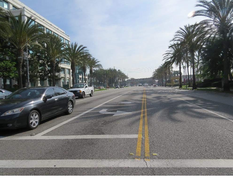
10 Applying These Measures to Real Compared the different measurement tools to each other Selected 5 street segments in the City of Santa Monica Arizona Ave Main Street 17th Street 20th Street Cloverfield Blvd Some tools have a lot of data needs including turning volumes Streets

11 Comparison results from 3 of 5 routes - all 5 in paper and report

12 Arizona Ave

13 17th Street
14 Cloverfield Blvd
15 Why do we see such variation in the scores? Each tool takes in different inputs, scored differently.


16 Charlotte intersection* Bicycle Pedestrian *charlotte methodology only measures intersections and takes all 4 approaches into account


17 BEQI/PEQI Link & Intersection Bicycle intersection: Right turn on red restrictions Bike lane striping through the intersection Availability of left-turn bike lane Pedestrian intersection Pedestrian link Bicycle link
18 Question Break
19 What is HCM MMLOS? A model for bicycle and pedestrian quality of service (BLOS and PLOS)
20 What is HCM MMLOS? A complex formula... Example: Link PLOS Fw = Width Factor Fv = Volumes Factor Fs = Speed Factor
21 What is HCM MMLOS? drawing on an exhaustive list of data Example: Link PLOS
22 Where did HCM MMLOS come from? Source Focus of study Location Number of participants ADT Roadway Variety (Landis, et al., 1997) Bicycle link Tampa, Florida ,000 mean of 12,000 (Landis, et al., 2001) Pedestrian link Pensacola, Florida ~75 (no exact number listed) ,500 (Landis, et al., 2003) Bicycle intersection Orlando, Florida. 59 (66% male) ,000 mean of 25,600 (Petritsch, et al., 2005) Pedestrian intersection Sarasota, Florida. 46 (67% female) Not noted.
23 Pedestrian LOS (PLOS): Overview Specific to a side of the street Intersection PLOS: # of lanes crossed Link PLOS: width of walking area Segment PLOS includes a crossing delay factor
24 Intersection PLOS: Highlights Lanes crossed: lose about a half grade per additional lane
 Fw = Width Factor Fv = Volumes Factor Fs = Speed")
25 Intersection PLOS: Highlights Delay is not important: add a minute of delay, drop 0.05 in score (<10% of a grade) Fw = Width Factor Fv = Volumes Factor Fs = Speed Factor

26 Link PLOS: Highlights Width and separation of walking area is very important Larger bonus for 100% on-street parking occupancy than for adding a sidewalk Not sensitive to presence of trees or lighting
27 Bicycle LOS: Overview Specific to a direction of travel Intersection BLOS: bicyclists operating space, traffic density Link BLOS: traffic volumes, heavy vehicles, bicyclists operating space Segment BLOS: error!
 Indifferent to intersection treatments: bicycle boxes, signals, markings through intersection No calculation for bicyclist")
28 Intersection BLOS: Highlights Width of the bicycle operating space is important Traffic density is important (traffic volumes / lane) Indifferent to intersection treatments: bicycle boxes, signals, markings through intersection No calculation for bicyclist delay
29 Link BLOS: Highlights Traffic volumes are very important, especially heavy vehicles Width of bicyclists operating space (typically bike lane) very important Pavement quality is not important The score is not affected by striping: bike lane width and striped buffer width are considered equivalent Link BLOS is unable to analyze physical separation

30 Link BLOS: Highlights Fw = Width Factor Fv = Volumes Factor Fs = Speed Factor
31 Segment BLOS: Highlights Segment BLOS has a mathematical error in it, and scores above C are not possible.
32 Question Break

33 Sensitivity Case Study: 20th Street Intersection changes
34 Scenario cheat sheet
35 BEQI/PEQI Results
36 Charlotte Results
37 HCM Results
38 Limitations across the board Measures could not distinguish between painted and physical buffer No measure was able to score physical separations (cycletracks) Painted lane also not in any tool input All tools are rather inflexible; while a spreadsheet tool is easier to manipulate than software
39 Conclusions and discussion No tool conclusively helped to select the best improvement scenario - silver bullet does not exist Each measure is mired in the time it was created which may be problematic as toolbox continues to grow Rather than try to replace auto LOS with biking and walking LOS, cities may be better served by thinking about the bicycling and pedestrian experience and what aspects of it they want to measure. Walking and bicycling are modes that are influenced by a variety of inputs so information may be lost in the grading process
40 Thank you! For more information and reports, please visit the project page: Herbie Huff Madeline Brozen
Moving Towards Complete Streets MMLOS Applications
 Moving Towards Complete Streets MMLOS Applications Transportation Education Series May 18 th, 2012 It s not just for cars! Presentation Overview The Complete Streets Movement What is Multi-Modal Level
feature Moving Ahead for Multimodal Performance Measures:
 feature Moving Ahead for Multimodal Performance Measures: Applying the Charlotte, NC Bicycle and Pedestrian Level of Service Tool in Santa Monica, CA By Madeline Brozen www.shutterstock.com/ IR Stone 36
BICYCLE LEVEL OF SERVICE for URBAN STREETS. Prepared by Ben Matters and Mike Cechvala. 4/16/14 Page 1
 BICYCLE LEVEL OF SERVICE for URBAN STREETS Prepared by Ben Matters and Mike Cechvala 4/16/14 Page 1 Introduction The methodology used for the Bicycle (BLOS) analysis is from the Highway Capacity Manual
Multimodal Analysis in the 2010 Highway Capacity Manual
 Multimodal Analysis in the 2010 Highway Capacity Manual It s not just cars anymore! Jamie Parks, AICP HCAT Conference May 9-10, 2011 Multimodal LOS in the 2010 HCM History and background Overview of methods
AN EXPOSITION OF THE HIGHWAY CAPACITY MANUAL'S BICYCLE LEVEL OF SERVICE MODEL
 AN EXPOSITION OF THE HIGHWAY CAPACITY MANUAL'S BICYCLE LEVEL OF SERVICE MODEL K. Herbie Huff (herbiehuff@luskin.ucla.edu)* Robin Liggett Correspondence address for all authors: UCLA Institute of Transportation
appendix b BLOS: Bicycle Level of Service B.1 Background B.2 Bicycle Level of Service Model Winston-Salem Urban Area
 appendix b BLOS: B.1 Background Winston-Salem Urban Area Bicycle Level of Service Level of Service (LOS) is a framework that transportation professionals use to describe existing conditions (or suitability)
Complete Street Analysis of a Road Diet: Orange Grove Boulevard, Pasadena, CA
 Complete Street Analysis of a Road Diet: Orange Grove Boulevard, Pasadena, CA Aaron Elias, Bill Cisco Abstract As part of evaluating the feasibility of a road diet on Orange Grove Boulevard in Pasadena,
Bicycle and Pedestrian Connectivity Study. Old Colony Planning Council
 Bicycle and Pedestrian Connectivity Study Old Colony Planning Council Outline Why consider bike/peds in road designs? Why are measures needed? Connecting Land Use with Transportation Evaluation Tools:
9/25/2018. Multi-Modal Level of Service (MMLOS) Bianca Popescu, Transportation Planner
 Bianca Popescu, Transportation Planner") Multi-Modal Level of Service (MMLOS) Bianca Popescu, Transportation Planner 1 What is MMLOS? Is this a nice place to walk? Is this a nice place to bike? Is transit convenient? Bottom line - Are there options
Multi-Modal Level of Service (MMLOS) Bianca Popescu, Transportation Planner 1 What is MMLOS? Is this a nice place to walk? Is this a nice place to bike? Is transit convenient? Bottom line - Are there options
Bicycle and Pedestrian Level of Service Measures
 Bicycle and Pedestrian Level of Service Measures June 5, 2003 Midwest Transportation Planning Conference Ed Barsotti League of Illinois Bicyclists 630-978-0583 ed@bikelib.org www.bikelib.org Outline Why
Addressing Deficiencies HCM Bike Level of Service Model for Arterial Roadways
 Petritsch, et al 1 1 2 3 4 5 6 7 8 9 10 11 12 13 14 15 16 17 18 19 20 21 22 23 24 25 26 27 28 Addressing Deficiencies HCM Bike Level of Service Model for Arterial Roadways Submitted July 31, 2013 Word
Implementing Complete Streets in Ottawa. Project Delivery Process and Tools Complete Streets Forum 2015 October 1, 2015
 Implementing Complete Streets in Ottawa October 1, 2015 The Essentials Complete Streets Implementation Framework will become part of the routine delivery of City transportation projects Approach uses every
Young Researchers Seminar 2011
 Young Researchers Seminar 2011 Young Researchers Seminar 2011 DTU, Denmark, 8 10 June, 2011 DTU, Denmark, June 8-10, 2011 Methods for assessing the pedestrian level of service: International experience
Columbia Pike Implementation Team (CPIT) Meeting
 Meeting") Columbia Pike Implementation Team (CPIT) Meeting November 30, 2010 Agenda Introductions / Purpose of Meeting Review of project goals Multimodal project: 10% street design between the curbs Discussion Multimodal
Columbia Pike Implementation Team (CPIT) Meeting November 30, 2010 Agenda Introductions / Purpose of Meeting Review of project goals Multimodal project: 10% street design between the curbs Discussion Multimodal
Multimodal Arterial Level of Service
 Multimodal Arterial Level of Service DOUGLAS S. MCLEOD Florida Department of Transportation, USA ABSTRACT The concept of quality of service from a user perspective of a transportation facility or service
International Journal of Mechanical Engineering and Technology (IJMET), ISSN 0976 INTERNATIONAL JOURNAL OF MECHANICAL ENGINEERING
, ISSN 0976 INTERNATIONAL JOURNAL OF MECHANICAL ENGINEERING") INTERNATIONAL JOURNAL OF MECHANICAL ENGINEERING AND TECHNOLOGY (IJMET) ISSN 0976 6340 (Print) ISSN 0976 6359 (Online) Volume 4, Issue 5, September - October (2013), pp. 244-249 IAEME: www.iaeme.com/ijmet.asp
INTERNATIONAL JOURNAL OF MECHANICAL ENGINEERING AND TECHNOLOGY (IJMET) ISSN 0976 6340 (Print) ISSN 0976 6359 (Online) Volume 4, Issue 5, September - October (2013), pp. 244-249 IAEME: www.iaeme.com/ijmet.asp
EXPLORATION AND IMPLICATIONS OF MULTIMODAL STREET PERFORMANCE METRICS: WHAT S A PASSING GRADE?
 University of California Transportation Center UCTC-FR-2014-09 EXPLORATION AND IMPLICATIONS OF MULTIMODAL STREET PERFORMANCE METRICS: WHAT S A PASSING GRADE? Madeline Brozen Herbie Huff Lewis Center for
Emerging Methods for Evaluating Transportation Systems Multimodal LOS and Highway Safety Manual
 Emerging Methods for Evaluating Transportation Systems Multimodal LOS and Highway Safety Manual November 8, 2012 Lake Merritt Tower in Oakland Transportation Education Series 1 Presenters Mark Bowman,
HIGHWAY CAPACITY MANUAL
 HISTORY OF THE HIGHWAY CAPACITY MANUAL TexITE - Houston Chapter November 10, 2010 Michael Y. Ereti City of Houston Department of Public Works & Engineering THE NEW GUY (Michael Ereti) Consultant (10 years)
Access Management in the Vicinity of Intersections
 Access Management in the Vicinity of Intersections FHWA-SA-10-002 Technical Summary Photo: Ralph Bentley (used with permission) 0 Access Management is: The design, implementation and management of entry
Dr. M.L. King, Jr. Street North Complete Streets Resurfacing Opportunities HOUSING, LAND USE, AND TRANSPORTATION COMMITTEE MARCH 22, 2018
 Dr. M.L. King, Jr. Street North Complete Streets Resurfacing Opportunities HOUSING, LAND USE, AND TRANSPORTATION COMMITTEE MARCH 22, 2018 What s Happening The City plans to mill and resurface Dr. M.L.
TOOLS FOR EVALUATING LEVEL & QUALITY OF SERVICE FOR ALL MODES: A LITERATURE REVIEW. Hillsborough County, Florida
 TOOLS FOR EVALUATING LEVEL & QUALITY OF SERVICE FOR ALL MODES: A LITERATURE REVIEW Hillsborough County, Florida August 2017 TOOLS FOR EVALUATING LEVEL & QUALITY OF SERVICE FOR ALL MODES: A LITERATURE REVIEW
Goodlettsville Bicycle and Pedestrian Plan Executive Summary
 Goodlettsville Bicycle and Pedestrian Plan July 2010 In Cooperation with the Nashville Area Metropolitan Planning Executive Organization Summary Introduction Progressive and forward thinking communities
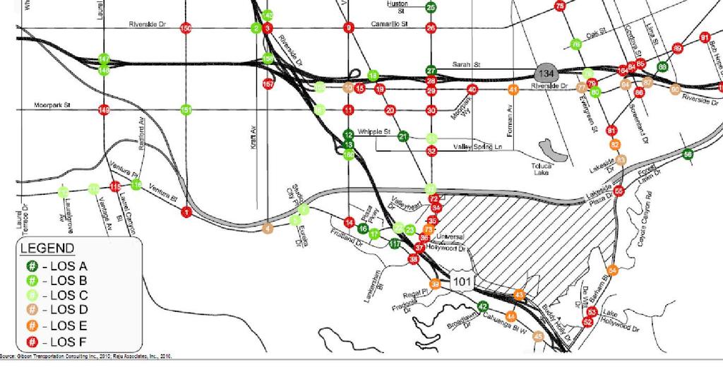
4.12 TRANSPORTATION Executive Summary. Setting
 4.12 TRANSPORTATION 4.12.1 Executive Summary This section is based on the Multimodal Transportation Impact Study (TIS; 2016) prepared by Omni-Means, Ltd. to evaluate projected transportation impact conditions
City of Sammamish. Welcome. Issaquah-Fall City Road Improvements Project Phase I Design: 242nd Avenue SE to Klahanie Drive SE
 Welcome Welcome to the third community meeting for the Issaquah-Fall City Road Improvements Project. AGENDA 6:00 p.m. Welcome and sign-in 6:10 p.m. Presentation 6:50 p.m. Open house Learn about the roadway
MAKE YOUR PLACE IN CHANNELSIDE
 MAKE YOUR PLACE IN CHANNELSIDE INTRODUCTION PROJECT LIMITS Channelside Drive from Cumberland Ave to Kennedy Boulevard EXISTING CONDITIONS EXISTING CONDITIONS CHANNELSIDE DRIVE FROM E. CUMBERLAND AVENUE
Bicycling and Walking
 Bicycling and Walking Performance Measures Traditional, the new Highway Capacity Manual, and beyond A New Game. Balanced transportation. Multi-modal Complete Streets Livability Sustainable Whatever Economically-Efficient
GIS Based Data Collection / Network Planning On a City Scale. Healthy Communities Active Transportation Workshop, Cleveland, Ohio May 10, 2011
 The Purpose of GIS Based Network Planning GIS Based Data Collection / Network Planning Healthy Communities Active Transportation Conference Tuesday, May 10, 2011 10:00 AM Norman Cox, LLA, ASLA. Ann Arbor,
Bicycle and Pedestrian Level of Service Evaluation
 Bicycle and Pedestrian Level of Service Evaluation June 214 Florida Department of Transportation Bicycle and Pedestrian Evaluation Prepared by Sprinkle Consulting Cambridge Systematics For the Florida
TRAFFIC IMPACT ANALYSIS
 TRAFFIC IMPACT ANALYSIS FOR THE CHAMPAIGN UNIT#4 SCHOOL DISTRICT PROPOSED HIGH SCHOOL (SPALDING PARK SITE) IN THE CITY OF CHAMPAIGN Final Report Champaign Urbana Urbanized Area Transportation Study 6/24/2014
Road Diets: Reconfiguring Streets for Multi-Modal Travel
 Road Diets: Reconfiguring Streets for Multi-Modal Travel Tom Grant, P.E., PTOE What is a Road Diet? Reconfiguration of travel lanes to benefit all roadway users (i.e., Complete Street) Reclaiming the space
TRANSPORTATION FACILITY PLANNING Waugh Chapel Road Maytime Drive to New Market Lane
 July 24, 2018 TRANSPORTATION FACILITY PLANNING Waugh Chapel Road Maytime Drive to New Market Lane DPWandYOU.com Making a difference, together Meeting Agenda Purpose of the project Overview of work conducted
Working White Paper on the Implementation of the Highway Capacity Manual 6 th Edition in Synchro
 Working White Paper on the Implementation of the Highway Capacity Manual 6 th Edition in Synchro 1 st Edition January 18, 2017 Copyright 1993-2017 Trafficware, LLC. All rights reserved. No part of this
A Traffic Operations Method for Assessing Automobile and Bicycle Shared Roadways
 A Traffic Operations Method for Assessing Automobile and Bicycle Shared Roadways A Thesis Proposal By James A. Robertson Submitted to the Office of Graduate Studies Texas A&M University in partial fulfillment
Who is Toole Design Group?
 2018 AASHTO Bike Guide Status Update NCHRP 15 60 Amalia Leighton Cody, PE, AICP & Kenneth Loen, PE Washington APWA October 4, 2018 Who is Toole Design Group? TDG is a full service engineering, planning
Waterford Lakes Small Area Study
 Waterford Lakes Small Area Study Existing Traffic Conditions PREPARED FOR: ORANGE COUNTY PUBLIC WORKS DEPARTMENT TRAFFIC ENGINEERING DIVISION ORLANDO, FLORIDA PREPARED WITH: INWOOD CONSULTING ENGINEERS
Cycle Track Design Best Practices Cycle Track Sections
 Design Best Practices Sections It is along street segments where the separation and protection methods of cycle tracks offer more comfort than conventional bicycle lanes, and are more attractive to a wide
City of Ottawa s Complete Streets Approach to Transportation Projects
 City of Ottawa s Complete Streets Approach to Transportation Projects Presentation to Stakeholders Date: May 5, 2015 Presentation Overview Purpose of the study Proposed definition of Complete Streets for
City of Charlottesville Bicycle and Pedestrian Master Plan Update
 City of Charlottesville Bicycle and Pedestrian Master Plan Update September 17, 2014 I. Welcome and meeting overview II. Project status update III. Network overview IV. Break-out groups Pedestrian Network
DEPARTMENT OF ENVIRONMENTAL SERVICES. North Harrison Street (Lee Highway to Little Falls Road) Comparative Analysis. Prepared for:
 Comparative Analysis. Prepared for:") DEPARTMENT OF ENVIRONMENTAL SERVICES North Harrison Street (Lee Highway to Little Falls Road) Comparative Analysis Prepared for: Arlington County Department of Environmental Services 2100 Clarendon Boulevard,
DEPARTMENT OF ENVIRONMENTAL SERVICES North Harrison Street (Lee Highway to Little Falls Road) Comparative Analysis Prepared for: Arlington County Department of Environmental Services 2100 Clarendon Boulevard,
Corridor Advisory Group and Task Force Meeting #10. July 27, 2011
 Corridor Advisory Group and Task Force Meeting #10 July 27, 2011 1 Agenda Recap CAG/TF #9 Public Meeting #2 Summary Single Mode Alternatives Evaluation Results Next Steps 2 3 CAG/TF #9 Recap CAG /TF #9
Bicycle Level of Service: Where are the Gaps in Bicycle Flow Measures?
 Portland State University PDXScholar Dissertations and Theses Dissertations and Theses Summer 9-18-2014 Bicycle Level of Service: Where are the Gaps in Bicycle Flow Measures? Pamela Christine Johnson Portland
STEERING COMMITTEE MEETING June 17, Streetscape Overview Burlington Comprehensive Master Plan
 STEERING COMMITTEE MEETING June 17, 2015 Streetscape Overview Burlington Comprehensive Master Plan 1 Introduction Slide This slide show was presented to the Burlington Steering Committee on June 17, 2015
2014 Regional Bicycle and Pedestrian Study Evaluation Tools Leslie A. Meehan, AICP MPO Technical Coordinating Committee Meeting April 1, 2015
 Mayor Mayor Kenneth Karl Dean, Wilber, Chairman 2014 Regional Bicycle and Pedestrian Study Evaluation Tools Leslie A. Meehan, AICP MPO Technical Coordinating Committee Meeting April 1, 2015 Evaluation
Road Diets FDOT Process
 Florida Department of TRANSPORTATION Road Diets FDOT Process Humberto Castillero, PE, PTOE Roadway Design Office Purpose of Guide Develop a statewide lane elimination review process Balance state & local
DOWNTOWN TUPELO MAIN STREET: ROAD DIET STUDY
 DOWNTOWN TUPELO MAIN STREET: ROAD DIET STUDY Since mid-2009, RPM Transportation Consultants (RPM) has worked with the Downtown Tupelo Main Street Association to evaluate traffic conditions and potential
CHAPTER 4 TRANSPORTATION IMPACT STUDY TABLE OF CONTENTS
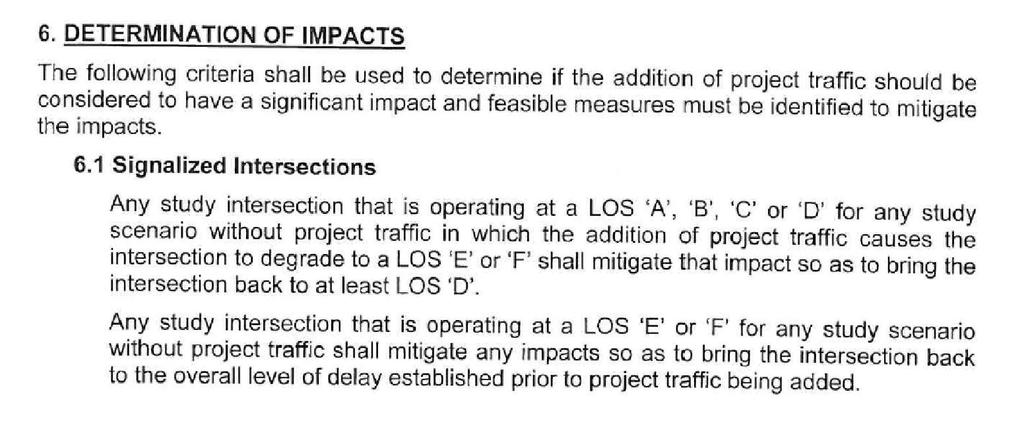
 CHAPTER 4 TRANSPORTATION IMPACT STUDY TABLE OF CONTENTS Section Title Page 4.1 Introduction... 4-1 4.1.1 General... 4-1 4.1.2 Applicant Responsibility... 4-1 4.1.3 Capacity and Safety Issues... 4-1 A.
CHAPTER 18 NEIGHBORHOOD TRAFFIC SAFETY TABLE OF CONTENTS
 CHAPTER 18 NEIGHBORHOOD TRAFFIC SAFETY TABLE OF CONTENTS Section Title Page 18.1 General... 18-1 18.1.1 Intended Use...18-1 18.1.2 Traffic Calming for New Street Design...18-1 18.1.3 Roundabouts and Mini
Why are we still talking about Complete Streets?
 Why are we still talking about Complete Streets? Jeremy R. Klop, AICP Complete Streets and Capital Projects Session March 1, 2013 Public Works Officers Institute League of California Cities Conference,
Complete Streets: Policy to Pavement
 Complete Streets: Policy to Pavement Darby Watson AICP ASLA LEED AP August 2, 2012 City of Pasadena Agenda Introductions Complete Streets Policy Planning for All Modes Design and Implementation Integration
Balancing Operation & Safety for Motorized and Non-Motorized Traffic
 Balancing Operation & Safety for Motorized and Non-Motorized Traffic Brian Willham, PE, PTOE Iowa Director - MOVITE June 30, 2014 Learning Objectives: When & Why should we measure the performance of complete
TECHNICAL MEMORANDUM 3: EXISTING CONDITIONS ANALYSIS FOR THE VILLAGE GREEN MULTIMODAL TRANSPORTATION DISTRICT
 TECHNICAL MEMORANDUM 3: EXISTING CONDITIONS ANALYSIS FOR THE VILLAGE GREEN MULTIMODAL TRANSPORTATION DISTRICT Prepared for: TREASURE COAST REGIONAL PLANNING COUNCIL Prepared by: RENAISSANCE PLANNING GROUP
Memorandum. Drive alone
 Memorandum To: Cc: From: Kimberly Kerr, Assistant Chief Administrative Officer Natalie Porter, PE, TE Shawna Purvines Claudia Wade, PE Michael Schmitt, AICP CTP, PTP Re: Technical Memorandum #2: Model
Truck Climbing Lane Traffic Justification Report
 ROUTE 7 (HARRY BYRD HIGHWAY) WESTBOUND FROM WEST MARKET STREET TO ROUTE 9 (CHARLES TOWN PIKE) Truck Climbing Lane Traffic Justification Report Project No. 6007-053-133, P 101 Ι UPC No. 58599 Prepared by:
Chapter Capacity and LOS Analysis of a Signalized I/S Overview Methodology Scope Limitation
 Chapter 37 Capacity and LOS Analysis of a Signalized I/S 37.1 Overview The Highway Capacity Manual defines the capacity as the maximum howdy rate at which persons or vehicle can be reasonably expected
TRAFFIC STUDY GUIDELINES Clarksville Street Department
 TRAFFIC STUDY GUIDELINES Clarksville Street Department 9/1/2009 Introduction Traffic studies are used to help the city determine potential impacts to the operation of the surrounding roadway network. Two
INTERSECTION LEVEL OF SERVICE: THE BICYCLE THROUGH MOVEMENT
 INTERSECTION LEVEL OF SERVICE: THE BICYCLE THROUGH MOVEMENT By Bruce W. Landis, Venkat R. Vattikuti, Russell M.Ottenberg, Theodore Petritsch, Martin Guttenplan, and Dr. Linda B.Crider 2002 A Paper submitted
TABLE OF CONTENTS. Executive Summary
 Executive Summary Background... ES-1 Pedestrian Network... ES-2 Bikeway Network... ES-2 Collision History... ES-2 Public Input... ES-4 Conclusions and Recommendations... ES-4 1. Introduction and Setting
Malabar Road (SR 514) PD&E. Town of Malabar Briefing (July 17, 2017)
 PD&E. Town of Malabar Briefing (July 17, 2017)") Malabar Road (SR 514) PD&E Town of Malabar Briefing (July 17, 2017) 1 Agenda Project limits and briefing focus PD&E process and project status Public and agency project comments Review Recommended Alternatives:
Malabar Road (SR 514) PD&E Town of Malabar Briefing (July 17, 2017) 1 Agenda Project limits and briefing focus PD&E process and project status Public and agency project comments Review Recommended Alternatives:
6.0 PEDESTRIAN AND BICYCLE FACILITIES 6.1 INTRODUCTION 6.2 BICYCLE DEMAND AND SUITABILITY Bicycle Demand
 6.0 PEDESTRIAN AND BICYCLE FACILITIES 6.1 INTRODUCTION Bicycle and pedestrian travel along and in the vicinity of the corridor is part of the vision of Somerset and Hunterdon counties and the integrated
Bicycle Facilities Planning
 Bicycle Facilities Planning Overview Types of Cyclists Purpose for Riding Types of Facilities Bike Lanes Bicycle Boulevards Cycle Tracks Intersections Signals Signing and Marking Discussion Types of Bicyclists
C C C
 C-012-001 Thank you for your support for the creation of new public space and nonmotorized access between downtown and the waterfront through the Overlook Walk, the East-West Connections, and the Promenade.
An Analysis of Reducing Pedestrian-Walking-Speed Impacts on Intersection Traffic MOEs
 An Analysis of Reducing Pedestrian-Walking-Speed Impacts on Intersection Traffic MOEs A Thesis Proposal By XIAOHAN LI Submitted to the Office of Graduate Studies of Texas A&M University In partial fulfillment
Planning Guidance in the 2012 AASHTO Bike Guide
 Planning Guidance in the 2012 AASHTO Bike Guide Presentation by: RJ Eldridge Peter Lagerwey August 22, 2012 WEBINAR 2: PLANNING GUIDANCE IN THE 2012 AASHTO BIKE GUIDE Today s Webinar Significant Updates
Bicycle and Pedestrian Counts in Carson: Results from Automated Counts in Herbie Huff, Madeline Brozen, Norman Wong and Diana Benitez
 Bicycle and Pedestrian Counts in Carson: Results from Automated Counts in 2013-2014 Herbie Huff, Madeline Brozen, Norman Wong and Diana Benitez Attribution This report is made possible with funding from
Average Delay/Vehicle (sec/veh) Signalized. Unsignalized Intersection
 Signalized. Unsignalized Intersection") Attachment: Traffic Analysis Results Traffic simulation modeling analysis was completed for Santa Cruz Ave from Alameda De Las Pulgas to Junipero Serra Blvd. Analysis was performed for existing conditions
Attachment: Traffic Analysis Results Traffic simulation modeling analysis was completed for Santa Cruz Ave from Alameda De Las Pulgas to Junipero Serra Blvd. Analysis was performed for existing conditions
MN Green Step Cities December 7, Hannah Pritchard, PE PTOE
 MN Green Step Cities December 7, 2016 Hannah Pritchard, PE PTOE Hannah Pritchard PE PTOE @bicyclehannah hpritchard@tooledesign.com Choose your own adventure How we got here the history of traffic engineering
Safety Impacts: Presentation Overview
 Safety Impacts: Presentation Overview The #1 Theme How Access Management Improves Safety Conflict Points The Science of Access Management By Treatment Studies Themes for Texas Access Management Improve
Application of New Pedestrian Level of Service Measures
 Application of New Pedestrian Level of Service Measures Sacramento Area Council of Governments June 2011 1 Table of Contents Sections 1. Purpose and Goals of Project 4 2. Terminology 5 3. Literature Review
MASTER BICYCLE AND PEDESTRIAN PLAN
 WELCOME! PLEASE FEEL FREE TO REVIEW THE EXHIBITS THE PRESENTATION WILL BEGIN AT 6:00 PM VILLAGE OF NORTHBROOK MASTER BICYCLE AND PEDESTRIAN PLAN DRAFT EXISTING CONDITIONS REPORT AND PUBLIC MEETING WELCOME!
5. RUNNINGWAY GUIDELINES
 5. RUNNINGWAY GUIDELINES These guidelines should be considered collectively when making runningway decisions. A runningway is the linear component of the transit system that forms the right-of-way reserved
STANLEY STREET December 19, 2017
 STANLEY STREET December 19, 2017 Welcome Mike Wiza, Mayor Scott Beduhn, Director of Public Works Agenda 1. Introduction 2. Existing Roadway Conditions 3. Current Alternative Improvements 4. Summary of
A Comprehensive HCM 2010 Urban Streets Analysis Using HCS 2010 US 31W in Elizabethtown, KY
 A Comprehensive HCM 2010 Urban Streets Analysis Using HCS 2010 US 31W in Elizabethtown, KY Ashley McLain, PE, PTOE Abstract The HCS 2010 Streets module was used to analyze a segment of the US 31W corridor
HENDERSON DEVELOPMENT 213, 217, 221, 221 ½, 223 HENDERSON AVENUE and 65 TEMPLETON STREET OTTAWA, ONTARIO TRANSPORTATION OVERVIEW.
 HENDERSON DEVELOPMENT 213, 217, 221, 221 ½, 223 HENDERSON AVENUE and 65 TEMPLETON STREET OTTAWA, ONTARIO TRANSPORTATION OVERVIEW Prepared for: 2294170 Ontario Inc. February 2, 2017 117-652 Report_1.doc
Section 7 Complete Green Street Guidelines DRAFT
 Section 7 Complete Green Street Guidelines DRAFT 1 Section: 7.0 COMPLETE GREEN STREET GUIDELINES These guidelines serve as options to mitigate the environmental impact of a project as well as guide the
Highway 111 Corridor Study
 Highway 111 Corridor Study June, 2009 LINCOLN CO. HWY 111 CORRIDOR STUDY Draft Study Tea, South Dakota Prepared for City of Tea Sioux Falls Metropolitan Planning Organization Prepared by HDR Engineering,
Rolling Out New Bike Facilities Within the North Bethesda & White Flint Area
 Rolling Out New Bike Facilities Within the North Bethesda & White Flint Area Rolling Out New Bike Facilities Within the North Bethesda & White Flint Area Agenda Designing for all Cyclists Background on
Environmental Assessment Findings & Recommendations. Public Hearing November 13, 2014
 Environmental Assessment Findings & Recommendations Public Hearing November 13, 2014 Welcome! Welcome and Introductions Project and Environmental Assessment Overview Public Comments Adjourn Purpose of
By Dan Burden, Executive Director Walkable and Livable Communities Institute
 By Dan Burden, Executive Director Walkable and Livable Communities Institute Is this the landscape we want to leave our children? LaJolla Boulevard, Birdrock, San Diego, CA 78 Feet Speeds above
Watertown Complete Streets Prioritization Plan. Public Meeting #1 December 14, 2017
 Watertown Complete Streets Prioritization Plan Public Meeting #1 December 14, 2017 Goals for Public Meeting Overview of MassDOT Complete Streets Funding Program Educate the community on Complete Streets
2.0 LANE WIDTHS GUIDELINE
 2.0 LANE WIDTHS GUIDELINE Road Engineering Design Guidelines Version 2.0.1 May 2018 City of Toronto, Transportation Services City of Toronto Page 0 Background In early 2014, Transportation Services initiated
Capacity and Level of Service LOS
 Chapter 21 Capacity and Level of Service LOS 21.1 Introduction Often it is required to ascertain how much a transport facility can accommodate. Such information is useful in the design of traffic facility.
HARRISON STREET/OAKLAND AVENUE COMMUNITY TRANSPORTATION PLAN
 HARRISON STREET/OAKLAND AVENUE Community Workshop #4: Draft Plan Review December 3, 2009 D E S I G N, C O M M U N I T Y & E N V I R O N M E N T INTRODUCTIONS Key Project Staff: Alisa Shen, Project Manager,
Complete Streets: Planning, Policy & Performance
 Complete Streets: Planning, Policy & Performance Tell Us About Your CS Experiences Successes Hardships Funding Politics Safety Not every street needs to be complete, but every mode needs a complete network.
Completing the Street: Denning Drive
 Completing the Street: Denning Drive Public Workshop and Walking Audit Winter Park Civic Center May 12, 2016 Completing the Street What Makes This a Complete Street? Completing the Street Complete Streets
The Traffic Monitoring Guide: Counting Bicyclists and Pedestrians. APBP 2017 June 28: 11:15am-12:45pm
 The Traffic Monitoring Guide: Counting Bicyclists and Pedestrians APBP 2017 June 28: 11:15am-12:45pm 2 Presentation Organization Why count bicyclists and pedestrians? Why report count data? What resources
Driverless Vehicles Potential Influence on Bicyclist Facility Preferences
 Driverless Vehicles Potential Influence on Bicyclist Facility Preferences MICHAEL BLAU, MCRP, LCI O T E C O C T O B E R 2 6, 2 0 1 6 S E S S I O N # 8 2 - E V A L U AT I N G T H E P E R F O R M A N C E
KEARNY MESA COMMUNITY PLAN UPDATE
 KEARNY MESA COMMUNITY PLAN UPDATE January 18, 2018 SUBCOMMITTEE MEETING Mobility Concepts and Urban Design Presentation Outline Mobility Concepts: Multimodal Planning Toolbox Presentation and Activities
MIT Kendall Square Initiative
 MIT Kendall Square Initiative Volume II: Technical Studies and Information (NoMa Project and SoMa Project) Final Development Plan Submission Cambridge Planning Board #302 and #303 November 5, Submitted
unsignalized signalized isolated coordinated Intersections roundabouts Highway Capacity Manual level of service control delay
 Whether unsignalized or signalized, isolated or coordinated, you can use TransModeler to simulate intersections with greater detail and accuracy than any other microsimulation software. TransModeler allows
Project Development & Environment (PD&E) Study. November 17, SR 90 (SW 8th Street and SW 7th Street) SW 8 th Street/SW 7 th Street PD&E Study 1
 Study. November 17, SR 90 (SW 8th Street and SW 7th Street) SW 8 th Street/SW 7 th Street PD&E Study 1") Financial Management Number: 432639-6-22-01 Federal Aid Project Number: 0202-054-P Efficient Transportation Decision Making Number: 14230 Project Development & Environment (PD&E) Study SR 90 (SW 8th Street
Financial Management Number: 432639-6-22-01 Federal Aid Project Number: 0202-054-P Efficient Transportation Decision Making Number: 14230 Project Development & Environment (PD&E) Study SR 90 (SW 8th Street
Project Report. South Kirkwood Road Traffic Study. Meadows Place, TX October 9, 2015
 Meadows Place, TX October 9, 2015 Contents 1 Introduction... 1 2 Data Collection... 1 3 Existing Roadway Network... 2 4 Traffic Volume Development... 2 5 Warrant Analysis... 3 6 Traffic Control Alternative
Aspects Regarding Priority Settings in Unsignalized Intersections and the Influence on the Level of Service
 Aspects Regarding Priority Settings in Unsignalized Intersections and the Influence on the Level of Service Dumitru Ilie, Matei Lucian, Vînatoru Matei, Racilă Laurențiu and Oprica Theodor Abstract The
Chapter 7: Six-Step Implementation Process
 Chapter 7: Six-Step Implementation Process The purpose of this chapter is to explain how the perspectives of all stakeholders interested in or affected by existing or future streets can be incorporated
Clybourn Ave. Protected Bike Lane Study Halsted St. to Division St.
 Clybourn Ave. Protected Bike Lane Study Halsted St. to Division St. Nathan Roseberry, Senior Engineer Pam Broviak, Project Manager July 24, 2014 Agenda Project Goals Existing Roadway Conditions Traffic
Complete Streets Policies in Charlotte
 Complete Streets Policies in Charlotte Complete Streets Peer Exchange Baton Rouge, LA January 19, 2016 Norm Steinman, AICP Charlotte DOT Changing what we do to change what will happen 1. Inventory of Conditions
Meade Street Bridge Design Alternative Study
 Meade Street Bridge Design Alternative Study Preferred Alternative Presentation Stakeholder Meeting #3 June 23, 2011 Presented by: Dan Biggs, RLA Meeting Agenda Purpose: 1. Review Meeting #2 Feedback 2.
MONTGOMERY COUNTY PLANNING DEPARTMENT THE MARYLAND-NATIONAL CAPITAL PARK AND PLANNING COMMISSION
 MONTGOMERY COUNTY PLANNING DEPARTMENT THE MARYLAND-NATIONAL CAPITAL PARK AND PLANNING COMMISSION MCPB Item No. 4 Date: 04-17-14 2014 Mobility Assessment Report José Dory, Senior Planner, Functional Planning
THIS PAGE LEFT BLANK INTENTIONALLY
 GA SR 25 Spur at Canal Road Transportation Impact Analysis PREPARED FOR GLYNN COUNTY, GEORGIA 1725 Reynolds Street, Suite 300 Brunswick, Georgia 31520 PREPARED BY 217 Arrowhead Boulevard Suite 26 Jonesboro,
US 41 COMPLETE STREETS CORRIDOR PLANNING STUDY from University Parkway to Whitfield Avenue
 41 US 41 COMPLETE STREETS CORRIDOR PLANNING STUDY from University Parkway to Whitfield Avenue EXECUTIVE SUMMARY DRAFT FEBRUARY 2019 Project Overview The US 41 Complete Streets Corridor Planning Study,