Lessons from the Green Lanes: Evaluating Protected Bike Lanes in the U.S.
|
|
|
- Norma Spencer
- 6 years ago
- Views:
Transcription

1 NATIONAL INSTITUTE FOR TRANSPORTATION AND COMMUNITIES FINAL REPORT Lessons from the Green Lanes: Evaluating Protected Bike Lanes in the U.S. NITC-RR-583 June 2014 A University Transportation Center sponsored by the U.S. Department of Transportation
2

3 LESSONS FROM THE GREEN LANES: EVALUATING PROTECTED BIKE LANES IN THE U.S. FINAL REPORT NITC-RR-583 Portland State University Alta Planning Independent Consultant June 2014
4
5 Technical Report Documentation Page 1. Report No. NITC-RR Government Accession No. 3. Recipient s Catalog No. 4. Title and Subtitle Lessons From The Green Lanes: Evaluating Protected Bike Lanes In The U.S. 7. Author(s) Chris Monsere, Jennifer Dill, Nathan McNeil, Kelly Clifton, Nick Foster, Tara Goddard, Matt Berkow, Joe Gilpin, Kim Voros, Drusilla van Hengel, Jamie Parks 9. Performing Organization Name and Address Chris Monsere Portland State University P.O. Box 751 Portland, Oregon Sponsoring Agency Name and Address National Institute for Transportation and Communities (NITC) P.O. Box 751 Portland, Oregon Report Date June Performing Organization Code 8. Performing Organization Report No. 10. Work Unit No. (TRAIS) 11. Contract or Grant No. NITC-RR Type of Report and Period Covered Final Report 14. Sponsoring Agency Code 15. Supplementary Notes 16. Abstract This report presents finding from research evaluating U.S. protected bicycle lanes (cycle tracks) in terms of their use, perception, benefits, and impacts. This research examines protected bicycle lanes in five cities: Austin, TX; Chicago, IL; Portland, OR; San Francisco, CA; and Washington, D.C., using video, surveys of intercepted bicyclists and nearby residents, and count data. A total of 168 hours were analyzed in this report where 16,393 bicyclists and 19,724 turning and merging vehicles were observed. These data were analyzed to assess actual behavior of bicyclists and motor vehicle drivers to determine how well each user type understands the design of the facility and to identify potential conflicts between bicyclists, motor vehicles and pedestrians. City count data from before and after installation, along with counts from video observation, were used to analyze change in ridership. A resident survey (n=2,283 or 23% of those who received the survey in the mail) provided the perspective of people who live, drive, and walk near the new lanes, as well as residents who bike on the new lanes. A bicyclist intercept survey (n= 1,111; or 33% of those invited to participate) focused more on people s experiences riding in the protected lanes. A measured increase was observed in ridership on all facilities after the installation of the protected cycling facilities, ranging from +21% to +171%. Survey data indicates that 10% of current riders switched from other modes, and 24% shifted from other bicycle routes. Over a quarter of riders indicated they are riding more in general because of the protected bike lanes. A large majority of drivers and bicyclists stated that they understood the intent of the intersection designs and were observed to use them as intended, though specific designs perform better than others on certain tasks. No collisions or near-collisions were observed over 144 hours of video review for safety at intersections, including 12,900 bicyclists. Residents and bicyclists indicated that any type of buffer shows a considerable increase in self-reported comfort levels over a striped bike lane, though designs with more physical separation had the highest scores. Buffers with vertical physical objects (those that would be considered protected lanes - e.g. with flexposts, planters, curbs, or parked cars) all resulted in considerably higher comfort levels than buffers created only with paint. Flexpost buffers got very high ratings even though they provide little actual physical protection from vehicle intrusions cyclists perceive them as an effective means of positive separation. Support for the protected lanes among residents was generally strong with 75% saying that they would support building more protected bike lanes at other locations, and 91% of surveyed residents agreed with the statement, I support separating bikes from cars. This agreement was high among primary users of all modes (driving, walking, transit, and bicycling), though motorists expressed concerns about the impacts of protected lanes on congestion and parking. Most residents also agreed with the statement I would be more likely to ride a bicycle if motor vehicles and bicycles were physically separated by a barrier, with Interested but Concerned residents expressing the highest level of agreement at 85%. Nearly three times as many residents felt that the protected bike lanes had led to an increase in the desirability of living in their neighborhood, as opposed to a decrease in desirability (43% vs 14%). 17. Key Words 18. Distribution Statement No restrictions. Copies available from NITC: Security Classification (of this report) 20. Security Classification (of this page) 21. No. of Pages Price Unclassified Unclassified i
6 ii
7 ACKNOWLEDGEMENTS DISCLAIMER iii
8 iv
9 v TABLE OF CONTENTS
10 vi
11 vii
12 viii
13 LIST OF TABLES ix
14 x
15 LIST OF FIGURES xi
16 xii
17 LIST OF ELECTRONIC APPENDICES xiii
18 xiv

19 EXECUTIVE SUMMARY Figure ES-1. Map of Study Cities Executive Summary ES 1
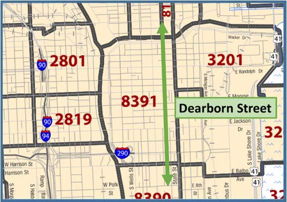
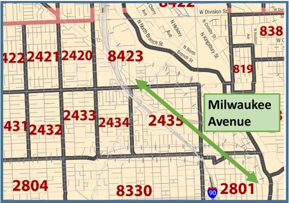
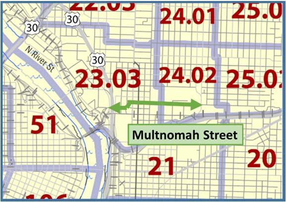
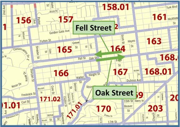
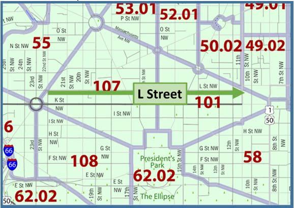
20 Study Sites Austin, Texas Barton Springs Road Bluebonnet Lane Rio Grande Street Chicago, Illinois Dearborn Street N. Milwaukee Avenue Portland Oregon NE Multnomah Street San Francisco, California Oak and Fell Street Washington, District of Columbia L Street ES 2 Executive Summary


21 Figure ES-2. Protected Bike Lanes included in the research Austin, TX: Barton Springs Road One-way protected bike lane on the south side of the road Bluebonnet Lane Two-way protected bike lane on a two-way street Rio Grande Street Two-way protected bike lane on one-way street Chicago, IL: N/S Dearborn Street Two-way protected bike lane on one-way street N Milwaukee Avenue Pair of one-way protected bike lanes on a two-way street Portland, OR: NE Multnomah Street Pair of one-way protected bike lanes on a two-way street San Francisco, CA: Oak Street One-way right-side lane on a one-way street Fell Street One-way left-side protected lane on a one-way street Washington, DC: L Street NW One-way protected bike lane on a one-way street Executive Summary ES 3
22 Table ES-1. Protected Bike Lane Elements Data Element Protected Lane Description Standard / Striped Bike Lanes (pre) Standard Traffic Lanes (pre) Loss of MV Travel Lane Barton Springs Road One-way EB protected lane on south side (+WB shared path on north side) ES 4 Executive Summary Austin Chicago Portland San Francisco Washington DC Bluebonnet N/S N Milwaukee NE Multnomah Rio Grande St Fell St Oak St L Street NW Lane Dearborn St Ave St Two-way protected lanes on twoway street Two-way protected lanes on oneway street Two-way protected lanes on one-way street Pair of oneway protected lanes on either side of twoway street Pair of one-way protected lanes on either side of two-way street One-way protected lane on oneway street One-way protected lane on oneway street One-way protected lane on one-way street None 1 nb, 1 sb 1 nb None 1 nb, 1 sb 1 eb, 1 wb 1 wb None None 2 eb, 1 ctr turn lane, 2 wb 1 nb, 1 sb 2 nb 3-4 nb 1 nb, 1 sb No No In places One lane Dedicated turn or bus lane in places 2 eb, 1 center turn lane, 2 wb One lane in each direction 3 wb 3 eb 3 eb No No In places Parking Allowed Right side, Left No Both sides Left Side Left side Both sides No Both sides Both sides (pre) side (flex) Net Loss of Parking No ~150 No gained ~28 ~27 ~150 Length (miles) # Signalized Intersections to # Unsignalized Intersections ADT (pre) 23-28,000 3,500 5, ,000 11,000 10, , ,000 10,000 Nov./ Dec. Construction Fall 2012/ Winter Spring Spring Spring 2013 August 2012 April , May April/May 2013 Timeframe 2013 /summer 2013 /summer October 2012 Bike Lane Width (representative) 5'-7' 5' + 5' 6.5' + 5.5' 5' + 4' 7' 4'-7' 7'3" 7'3" 8' Buffer Type Flexposts Flexposts Flexposts Flexposts; MV parking Flexposts; MV Parking Concrete Planters; MV Parking Flexposts Flexposts Flexposts Typical Buffer 3'; 8' parking 2-4'; 9' parking 1.5' 3' 4' Width strip strip 2'-8' 5' 5' 3' # Bicycle Signals to Typical MV Lane Width 10' ' 14 9'-10' 10'-11' 10' 9'6" 9'6" 11' # Mixing or Turning zones
23 Data and Methods Table ES-2. Data used in Analysis, by Site Austin Chicago Portland San Francisco Washington DC Barton Springs Bluebonnet Lane Rio Grande Dearborn Milwaukee NE Multnomah Fell Oak L Street Video Data Bicyclist Survey Resident Survey Count Data Note: Due to construction activity and routes with relatively low traffic volumes at intersections, no video data were collected for the Austin locations actual behavior stated Table ES-3. Overview of Data used in Analysis Research Element Video Data Bicyclist Survey Resident Survey Count Data Change in Ridership Design Evaluation Safety Perceptions of Residents Appeal to Different Groups Economic Activity Executive Summary 5
24 Four year degree + Income >$100k Work From Home Work Outside Home Asian Hispanic or Latino/a Black White 55 + years 35 to 54 years <35 years of age Female Own working bicycle Own/Lease a car Car Share Membership Transit Pass Driver's License Children in HH 2+ Adults in HH Home Owners 6% 5% 5% 15% 18% 15% 41% 50% Figure ES-3. Resident and Bicyclist Survey Respondent Demographics Findings: Changes in Ridership 66% 34% 40% 26% 53% 67% 64% 55% 81% 81% 83% 96% 0% 20% 40% 60% 80% 100% Residents 7% 7% 5% 1% 6% 28% 25% 37% 32% 48% 56% 73% 72% 78% 89% 93% 89% 97% 0% 20% 40% 60% 80% 100% Intercepted Bicyclists 6 Executive Summary
25 180% 171% 160% Two-way Percent Increase 140% 120% 100% 80% 60% 126% 68% One-way 46% 46% 65% 58% 40% 20% 21% 0% Rio Grande Multnomah Bluebonnet Fell Milwaukee Dearborn L Street Barton Springs Bike lanes prior Figure ES-4. Change in Observed Bicycle Volumes No bike lanes prior 100% 17% 80% 60% 21% 55% 56% 56% 65% 75% 80% 83% By bicycle, using this same route Would not have taken trip By other mode 40% 60% 7% 10% 10% 6% By bicycle, using another route 20% 0% 38% 6% 34% 32% 29% 7% 18% 10% 11% 6% Dearborn Rio Grande Multnomah L Street Barton Springs Oak Street Fell Street Milwaukee Figure ES-5. Before the new facility was built, how would you have made this trip? Executive Summary 7
26 Findings: Effectiveness of the Intersection Designs Mixing Zone with Yield Markings Mixing Zone with Yield MarkingsTurning Zone with Post-Restricted Entry and TBL 8 Executive Summary


: L Street 87% 91% 64%")


27 Table ES-4. Turning Motor Vehicle and Through Bicycle Use of Intersections Image Design Type Video: Correct Lane Use Turning Motorist Through Bicyclist Survey: % of Bicyclists Agreeing They Feel Safe Turning Zone with Post Restricted Entry and Through Bike Lane (TBL): L Street 87% 91% 64% Mixing Zone with Yield Entry Markings: NE Multnomah / 9th 93% 63% 73% Turning Zone with Unrestricted Entry and Through Bike Lane (TBL): Oak/ Divisadero 66% 81% 74% Mixing Zone with Sharrow Marking: Oak/Broderick 48% 30% 79% Mixing Zone with Green Skip Coloring: Fell/Baker 49% - 84% Executive Summary 9
 Very Uncomfortable (2) (3) (4) (5) (6) Very Comfortable With a striped bike lane (no buffer) With planters separating the bikeway With a 2-3")
28 Findings: Use of Traffic Signals to Separate Movements Figure ES-6. Bicyclists wait at a bike signal on Dearborn Street. Findings: Buffer Designs Influence Cyclist Comfort (1) Very Uncomfortable (2) (3) (4) (5) (6) Very Comfortable With a striped bike lane (no buffer) With planters separating the bikeway With a 2-3 foot buffer and plastic With a raised concrete curb With a painted buffer and parked cars With a painted 2-3 foot buffer With a solid painted buffer 0% 25% 50% 75% 100% Figure ES-7. Bicyclists Stated Comfort Level with Hypothetical Buffer Options 10 Executive Summary
29 Findings: Perceived Safety for All Users Austin Barton Springs Austin Rio Grande 56% 66% 33% 27% Chicago Dearborn Chicago Milwuakie Portland Multnomah SF Oak / Fell DC L Street 65% 59% 66% 82% 81% 31% 33% 29% 18% 18% 0% 20% 40% 60% 80% 100% Increased a Lot Increased Somewhat Figure ES-8. Bicyclists: "I feel the safety of bicycling on has..." Portland, Multnomah San Francisco, Oak Walking Driving Austin, Bluebonnet Austin, Barton Springs Chicago, Milwaukee Chicago, Dearborn Washington, D.C. - L St. 0% 20% 40% 60% 80% 100% Percent of Residents Stating "safety increased" Figure ES-9. Residents: Because of the protected bike lanes, the safety of on the street has increased Bicycling Executive Summary 11
30 Findings: Observed Safety Findings: Overall Support for the Protected Lane Concept Because of the protected bike lanes, how well the street works for all people has increased I would support building more protected bike lanes at other locations All residents Figure ES 1. Residents Opinions of Protected Bike Lanes, by Commute Mode 12 Executive Summary
31 Findings: Neighborhood Desirability and Economic Activity Findings: Potential to Attract New Riders Interested but Concerned Interested but Concerned Strong and Fearless, 5% Enthused and Confident, 27% Interested but Concerned, 43% Share of Residents No Way No How, 25% I would be more likely to ride a bicycle if motor vehicles and bicycles were physically separated by a barrier. 85% 43% Strong and Fearless 62% Enthused and Confident Interested but Concerned 37% No Way No How Figure ES-2. Residents Likelihood of Riding with Physical Separation by Type of Cyclist Executive Summary 13
32 Findings: Perceptions of People Driving on the Street 14 Executive Summary
33 1 INTRODUCTION Pucher et al., 2010) (Pucher et al., 2011). (Nelson and Allen, 1997; Dill and Carr, 2003; Buehler and Pucher, 2011) NACTO, 2011 Winters and Teschke, 2010; Monsere et al., 2012; Goodno et al., 2013Lusk et al., 2011; Harris et al., 2013; Lusk et al., 2013; Thomas and DeMartis, 2013 Urban Bikeway Design Guide (Bikes Belong, 2013) Introduction 1
34 1.1 Research Objectives 1.2 Organization of Report 2 Introduction


35 o o o o o o 1.3 Terminology Summary and List of Abbreviations Table 1-1. Definitions of Common Terminology in the Report Bicycle signals Term Definition Traffic signals intended to control bicycle movements. In the context of this study, the signals used the bicycle symbol in the R-Y-G lens to communicate this message. Bike box A space reserved for bicycles to stop ahead of the stop bar for motor vehicles at the intersection approach. Introduction 3
 or adjacent to a parking strip (right). Extra space separating the bike lane and the standard moving traffic lanes.")


.")
.")


36 Term (Standard) Bike Lane Buffer Chevrons Definition A standard bike lane usually consists of a four to six foot lane, separated from traffic lanes by a six- to eightinch white line. They may be either curb-tight (left) or adjacent to a parking strip (right). Extra space separating the bike lane and the standard moving traffic lanes. A buffer may have flexposts or other vertical protection. A double v-shaped pavement marking often used for lane guidance. Part of the shared use marking (MUTCD Fig 9C- 9). Construction/Installation Flex parking Flexpost In this report, the construction or installation of a protected bike lane refers to the time when the street was altered from its pre-existing layout to the updated protected layout. A lane or portion of a lane designated for parking at certain times and as a moving traffic lane at other times (usually used for peak hour capacity). A plastic post attached to the street surface. Flexposts are flexible and are generally designed to withstand being driven over while imposing minimal damage to vehicles. Also known as a safe hit post, soft hit post, delineator post, etc. Green skip coloring A green pavement marking that consists of staggered wide green stripes that mark a right-turn lane as shared space (used in San Francisco). Mixing zone On-street facility Parking buffer Protected bike lane Shared-use path Sharrow Through bike lane A shared turn lane and bike lane at an intersection where bicyclists and turning motor vehicles are both allowed. A facility that is within the curb-to-curb area of the streetscape (e.g., as opposed to the sidewalk, etc.). A buffer that consists of parking strip spaces (and an additional 2-3 space for opening doors and passenger entrance/exit). Protected bike lanes are bicycle exclusive lanes with protected separation between the bike lane and standard traffic lanes where moving motor vehicles may be operating. Protection may be in the form of buffered space with flexposts, a curb, a parking strip, planters, or other vertical separation. They may be either one- or two-way. They are also known as cycle tracks. A path designated for non-motorized traffic, including bicycles, pedestrians and other non-motorized vehicles. Also called a Shared Lane Marking (MUTCD Fig 9C- 9) consisting of a double chevron and bicycle symbol indicating that a lane is marked for bicycle shared use. A derivation of the sharrow with a green background (right) used in San Francisco. A marked bike lane that suggests where bicyclists should ride that is used in the turning zone designs. These bike lanes makings are dashed rather than solid meaning motor vehicles may use these lanes when no bicycles are present. Abbreviated in places as TBL. 4 Introduction
37 Term Definition Turning zone Two-stage turn queue box Intersection designs where the protected lane ends and transitions to a through bike lane adjacent to a motor vehicle turning lane. Similar to a combined turn lane. A marked space for bicyclists to wait before making the second stage of a two-stage turn. Table 1-2. Abbreviations or Alternatives Used in the Report Primary Use in Report Austin, TX Avenue Barton Springs Road Bluebonnet Lane Boulevard Chicago, IL Construction Fell Street Green Lanes Project L Street Motor vehicle N Milwaukee Avenue n N/S Dearborn Street National Association of City Transportation Officials NE Multnomah Street North/South/East/West Northbound/ Southbound/ Eastbound/ Westbound Oak Street Portland, OR Protected Bike Lane Rio Grande Street San Francisco, CA Through Bike Lane Street Washington, D.C. May also be referred to as: Austin Ave Barton Springs; BS Road Bluebonnet; BB Lane Blvd Chicago; Chi Installation Fell GLP L St MV Milwaukee Avenue; Milwaukee; Milw Ave Number in sample Dearborn Street; Dearborn NACTO Multnomah Street; Mult St N/S/E/W, as well of compound directions (e.g. NE, SW) NB/SB/EB/WB Oak Portland; PDX Protected lane; Cycle track; Separated bike lane; Facility Rio Grande; RG Street San Francisco; SF TBL St DC Introduction 5
38 2 FINDINGS OF PRIOR RESEARCH (Shafizadeh and Niemeyer, 1997; Rose and Marfurt, 2007; Emond et al, 2009; Winters and Teschke, 2010)2010 Lusk et al., 2011 (Tilahun et al, 2007; Stinson and Bhat, 2003; Hunt and Abraham, 2007; Akar and Clifton, 2009 (Winters and Teschke, 2010; Jackson and Ruehr, 1998; Garrard et al, 2008; Krizek et al, 2005). Sanders, 2013 Monsere et al., 2012; Goodno et al., 2013 (2011) Lusk et al., 2013 Harris et al., 2013 Thomas and DeMartis, Findings of Prior Research
39 (Jensen 2008) Wachtel and Lewiston, 1994) (2011) Wen and Rissel, 2008; Saelensminde, 2004; Meletiou et al, 2005; Busbee, 2005; Grabow et al, 2010; CRESP, 2000). Bicycle Federation of Wisconsin, 2005Alta Planning + Design, 2008 NYC Department of Transportation, 2012) Clifton et al, 2013; Drennen, 2003; Meisel, 2010 Findings of Prior Research 7

40 3 DESCRIPTION OF STUDY FACILITIES Table 3-1. Study Cities and Facilities City Facility Studied Type of Protected Facility Washington, D.C. L Street One-way protected lane on a one-way street Austin, TX Bluebonnet Lane Barton Springs Road Rio Grande Street Two-way protected lane on a two-way street One-way protected lane on the south side of the road (other direction is shared use path) Two-way protected lane on one-way street San Francisco, CA Oak /Fell Streets Couplet of one-way protected lanes on one-way streets Chicago, IL Portland, OR N/S Dearborn Street N Milwaukee Avenue NE Multnomah Street Two-way protected lane on one-way street One-way protected lanes on either side of a two-way street One-way protected lanes on either side of a two-way street Figure 3-3. Study Cities 8 Description of Study Facilities

41 3.1 Austin, TX Source: Google Maps Figure 3-4. Overview Map of Austin Study Facilities Barton Springs Road Description of Study Facilities 9


42 (Photos: City of Austin) Figure 3-5. Barton Springs Road Protected Bike Lane, Austin, TX Figure 3-6. Barton Springs Road, Austin, TX, Before and After Installation of Protected Bike Lane 10 Description of Study Facilities


43 Graphics Source: Streetmix.com Figure 3-7. Sample Cross section of Barton Springs Protected Bike Lanes Source: Google Maps Figure 3-8. Vicinity Map of Barton Springs Facility Extents Description of Study Facilities 11

44 3.1.2 Bluebonnet Lane Figure 3-9. Bluebonnet Lane Protected Bike Lanes, Austin, TX 12 Description of Study Facilities


45 Figure Bluebonnet Lane, Austin, TX, Before and After Installation of Protected Bike Lane Graphics Source: Streetmix.com Figure 3-9. Sample Cross section of Bluebonnet Protected Bike Lanes Description of Study Facilities 13

46 Source: Google Maps Figure Vicinity Map of Bluebonnet Lane Facility Extents Rio Grande Street 14 Description of Study Facilities


47 Figure Rio Grande Street Protected Bike Lanes, Austin, TX Figure Rio Grande Street, Austin, TX, Before and After Installation of Protected Bike Lane Description of Study Facilities 15


48 Graphics Source: Streetmix.com Figure Sample Cross section of Rio Grande Protected Bike Lane Source: Google Maps Figure Vicinity Map of Rio Grande Facility Extents 16 Description of Study Facilities

49 3.2 Chicago, IL Source: Google Maps Figure Overview Map of Chicago Study Facilities Dearborn Street Description of Study Facilities 17


50 Figure Dearborn Street Protected Bike Lanes, Chicago, IL Figure Dearborn Street, Chicago, IL, Before and After Installation of Protected Bike Lane 18 Description of Study Facilities


51 Graphics Source: Streetmix.com Figure Sample Cross section of Dearborn Street Protected Bike Lanes Source: Google Maps Figure Vicinity Map of Dearborn Street Facility Extents Milwaukee Avenue Description of Study Facilities 19

52 Figure Milwaukee Ave. Protected Bike Lanes, Chicago, IL 20 Description of Study Facilities


53 Figure Milwaukee Ave. Chicago, IL, Before and After Installation of Protected Bike Lane Graphics Source: Streetmix.com Figure Sample Cross section of Milwaukee Protected Bike Lanes Source: Google Maps Figure Vicinity Map of Milwaukee Facility Extents Description of Study Facilities 21

54 3.3 Portland, OR Source: Google Maps Figure Overview Map of Portland Study Facilities NE Multnomah Street 22 Description of Study Facilities


55 Figure NE Multnomah St. Protected Bike Lanes, Portland, OR Figure NE Multnomah St., Portland, OR, Before and After Installation of Protected Bike Lane Description of Study Facilities 23


56 Graphics Source: Streetmix.com Figure Sample Cross section of NE Multnomah Protected Bike Lanes Lloyd Mall Source: Google Maps Figure Vicinity Map of NE Multnomah Facility Extents 24 Description of Study Facilities

57 3.4 San Francisco, CA Source: Google Maps Figure Overview Map of San Francisco Study Facilities Oak and Fell Street Description of Study Facilities 25

58 Figure Fell and Oak Street Protected Bike Lanes, San Francisco, CA 26 Description of Study Facilities
 and Oak Street (bottom),")


59 Figure Fell Street (top) and Oak Street (bottom), San Francisco, CA, Before and After Installation of Protected Bike Lane Graphics Source: Streetmix.com Figure Sample Cross section of Fell Street Protected Bike Lane Description of Study Facilities 27


60 Graphics Source: Streetmix.com Figure Sample Cross section of Oak Street Protected Bike Lane Source: Google Maps Figure Vicinity Map of Oak/Fell Facility Extents 28 Description of Study Facilities

61 3.5 Washington, D.C. Source: Google Maps Figure 3-35 Overview Map of Washington, D.C., Facilities Description of Study Facilities 29


62 Figure L Street Protected Bike Lane, Washington, D.C. Figure L Street, Washington, D.C., Before and After Installation of Protected Bike Lane 30 Description of Study Facilities


63 Graphics Source: Streetmix.com Figure Sample cross section of L Street Protected Bike Lane Source: Google Maps Figure Vicinity Map of L Street Facility Extents 3.6 Summary of Facility Data Description of Study Facilities 31
64 Table 3-2. Pre-Installation Characteristics of Study Routes Data Element Barton Springs Road Austin Chicago Portland San Francisco Washington DC Bluebonnet Lane Rio Grande St N/S Dearborn St N Milwaukee Ave NE Multnomah St Fell St Oak St L Street NW From S 1st St Rabb Glen St W MLK Jr Blvd W Polk W Kinzie NE 1st St Scott St Baker St Penn. Ave To S Lamar Blvd Rabb Rd W 24th St W Kinzie N Elston NE 13th St Baker St Scott St Mass. Ave Standard Traffic Lanes Standard / Striped Bike Lanes 2 eb, 1 center turn lane, 2 wb 1 nb, 1 sb 2 nb 3-4 nb 1 nb, 1 sb 2 eb, 1 center turn lane, 2 wb 3 wb 3 eb 3 eb None 1 nb, 1 sb 1 nb None 1 nb, 1 sb 1 eb, 1 wb 1 wb None None Parking Allowed No Both sides Left Side Left side Both sides No Both sides Both sides Right side, Left side (flex) Length (miles) # Signalized Intersections # Unsignalized Intersections to ADT 23-28,000 3,500 5, ,000 12,000 10,000 28,000 30, ,000 Transit stops on route Yes No No Yes Yes Yes No No No Speed Limit % Speed (MPH) n/a n/a 30.5 n/a 32 Description of Study Facilities
65 Table 3-3. Post-Installation Roadway Characteristics Data Element Protected Lane Description Construction Timeframe BL Placement (in relation to traffic) Bike Lane Width (representative) Barton Springs Road One-way EB protected lane on south side (+WB shared path on north side) Austin Chicago Portland San Francisco Washington DC Bluebonnet Rio N/S N Milwaukee NE Multnomah Fell Oak L Street NW Lane Grande St Dearborn Ave Two-way protected lanes on two-way street Two-way protected lanes on one-way street Spring 2013 August 2012 April 2012 Two-way protected lanes on oneway street Nov./ Dec and May 2013 Pair of oneway protected lanes on either side of twoway street April/May 2013 Pair of one-way protected lanes on either side of two-way street Fall 2012/ Winter 2013 One-way protected lane on oneway street Spring /summer 2013 One-way protected lane on oneway street Spring /summer 2013 One-way protected lane on one-way street October 2012 Right Right Left Left Right Right Left Right Left 5'-7' 5' + 5' 6.5' + 5.5' 5' + 4' 7' 4'-7' 7'3" 7'3" 8' Buffer Type Flexposts Flexposts Flexposts Typical Buffer Width 1.5' 2' 4' Flexposts; MV parking 3'; 8' parking strip Paint; Flexposts; MV Parking 2-4'; 9' parking strip Concrete Planters; MV Parking Flexposts Flexposts Flexposts 2'-8' 5' 5' 3' # Bicycle Signals to Loss of Loss of MV Travel dedicated turn One lane in No No In places One lane Lane or bus lane in each direction No No In places places Net Loss of Parking No ~150 No gained Typical MV Lane Width 10' ' 14 9'-10' 10'-11' 10' 9'6" 9'6" 11' # Mixing or Turning zones (6 bus/bike; 3 bus/mv/bike; 2 mv/bike) ADT n/a n/a n/a n/a n/a 7,600 n/a n/a n/a 85% speed n/a n/a n/a n/a n/a n/a 25 n/a Description of Study Facilities 33
66 4 METHODOLOGY Fall 2012 Winter/Spring 2013 Summer/Fall 2013 Early 2014 Study Kickoff and Planning Site Visits and Facility Specific Methodology and Design Data Collection and Analysis Resident Surveys (mail/paper & electronic) Findings Project Planning and Methodology Survey Design Bicyclist Surveys (intercept/electronic) Video Collection and Review Analysis Final Report Initial Data Collection Input from GLP partners Facility- Specific Methodology Design Count Data Economic Impact Follow-Up Economic Follow-up Report (TBD) Figure 4-1. Diagram of Study Elements 34 Methodology
67 Table 4-1. Timeline of Project Data Collection Efforts City Washington, D.C. Austin, TX San Francisco, CA Route Site Visit* Resident Survey Bicyclist Intercept Survey Video Data Collection Dates L Street January May - June June May 14/15/16 Bluebonnet Lane Barton Springs Road Rio Grande Street April July - August - - April July - August April - June (+ October) June (+ October) Oak Street May September - October August September 25/26/28 1 Fell Street May September - October August September 25/26/ Chicago, IL Portland, OR N/S Dearborn Street N Milwaukee Avenue NE Multnomah Street May September - October September October 2/3/4 1 May September - October September September 25/26 1 July October - November October October 8/9 *All dates Other dates were also collected at certain locations due to equipment failure or another issue on one of the original planned dates 4.1 Video Collection and Review Methodology 35
 from")

68 Figure 4-2. Example Video Screenshots (2 views) from San Francisco at Oak and Broderick Video Review Objectives stated Location Selection 36 Methodology
69 Table 4-2. Summary of Video Data Collection Washington, D.C. San Francisco Portland Chicago Facility Cross Street Type Description Video Date Video Day N/S Dearborn Street N Milwaukee Avenue NE Multnomah Street Congress Parkway Madison Street Randolph Street Elston Avenue 9th Street 11th Street Intersection Intersection Intersection Intersection Intersection Transit Fell Street Baker Street Intersection Oak Street L Street NW Broderick Street Divisadero Street Btwn 19 th St and 18 th St 15th Street Connecticut Avenue Intersection Intersection Hotel Zone Intersection Intersection Two-way facility, MV leftturn signalized Two-way facility, MV leftturn signalized Two-way facility, MV leftturn signalized Bicycle signal, right-turn over facility Mixing zone w/ rightturning MVs Right-turn over facility, skip crossing markings Mixing Zone with Green Skip Coloring (Left turns) Mixing Zone with Sharrow Marking (Right Turns) Turning Zone with Unrestricted Entry and TBL Loading zone with MV entrance and exit Turning Zone with Post Restricted Entry and Through Bike Lane (TBL) Turning Zone with Post Restricted Entry and Through Bike Lane (TBL) 10/2/2013 Wednesday 10/3/2013 Thursday 10/4/2013 Friday 10/2/2013 Wednesday 10/3/2013 Thursday 10/4/2013 Friday 10/2/2013 Wednesday 10/4/2013 Friday 10/22/2013 Tuesday 9/25/2013 Wednesday 9/26/2013 Thursday 10/8/2013 Tuesday 10/9/2013 Wednesday 10/8/2013 Tuesday 10/9/2013 Wednesday 9/25/2013 Wednesday 9/26/2013 Thursday 9/28/2013 Saturday 9/25/2013 Wednesday 9/26/2013 Thursday 11/9/2013 Saturday 9/25/2013 Wednesday 9/26/2013 Thursday 9/28/2013 Saturday 5/15/2013 Wednesday 5/16/2013 Thursday 5/14/2013 Tuesday 5/15/2013 Wednesday 5/14/2013 Tuesday 5/15/2013 Wednesday Video Data Reduction Bicyclist Behaviors and Paths Methodology 37
70 Through Bike Lane Use: Stopping Location: Signal Compliance: Turning Movement: Number of Bikes at Intersection: Avoidance Maneuvers/Conflicts: Dill et all, 2011; Allen et al., 2005; Atkins, 2005; Hunter, 2000) 38 Methodology
71 Cyclist Location: Direction: Bus Interaction: Motor Vehicle Driver Behaviors and Paths Vehicle Type: Turning or Mixing Zone/Turn-Lane Entrance: Merging Vehicle/Bike Interaction: Methodology 39
72 Through Bike Lane Encroachment: Stopping Location: Turning Location: Turning Vehicle/Bike Interaction: Signal Compliance: Video Data Reduction Process 40 Methodology
73 Quality Control Methodology 41
74 4.1.4 Results 42 Methodology
75 Table 4-3. Number of Observations at Each Location Facility Cross Street Time Period 1 Bicyclists Turning/Merging Motor Vehicles Washington, D.C. San Francisco Portland Chicago N/S Dearborn Street N Milwaukee Avenue NE Multnomah Street Fell Street Oak Street L Street NW Congress Parkway Madison Street Randolph Street Elston Avenue 9th Street 11 th Street (Transit Stop) Baker Street Broderick Street Divisadero Street Btwn 19 th St and 18 th St 15th Street Connecticut Avenue 7-9 a.m a.m. 1 p.m p.m a.m , a.m. 1 p.m , p.m. 2 1,283 1, a.m , a.m. 1 p.m , p.m. 2 1,278 1, a.m a.m. 1 p.m p.m. 1,679 1, a.m a.m. 1 p.m p.m a.m a.m. 1 p.m p.m a.m a.m. 1 p.m p.m p.m a.m a.m. 1 p.m p.m p.m a.m a.m. 1 p.m p.m p.m a.m a.m. 1 p.m p.m a.m a.m. 1 p.m p.m a.m a.m. 1 p.m p.m All time periods includes two weekdays, unless otherwise noted, 2 Includes three weekdays, 3 Includes only one Saturday Methodology 43
76 4.2 User Surveys Survey Objectives Survey Design and Refinement 44 Methodology
77 4.2.3 Survey Instruments Resident Survey Structure Methodology 45
78 Travel Habits/ Opinions Driving Bicyclist Survey Structure Overall impacts of the lanes Facility-Specific Questions Demographics Figure 4-3. Resident Survey Structure Bicycling Walking Business 46 Methodology
79 Travel habits/opinions Trip Details Facility-Specific Demographics Figure 4-4. Bicyclist Survey Structure Survey Administration Experience with operations and safety Bikeway encounters and collisions Unique facility treatments and intersections Survey Distribution Method Response Method Return Paper Copy Resident Survey Paper Copies Mailed Complete Online Version Bicyclist Survey Intercept Complete Online Version Figure 4-5. Survey Administration Methods Methodology 47
80 Resident Survey Bicyclist Survey Intercepted Bicyclists 48 Methodology
81 Bicyclist Survey Open Survey 4.3 Bicycle Count Data City Bicyclist Counts Methodology 49
82 Table 4-4. Count Data Provided by Participating Cities City Street (s) Count Type Before Counts After Counts Austin Chicago Barton Springs Road Bluebonnet Lane Rio Grande St N/S Dearborn St N Milwaukee Ave Tube counter Tube counter Tube counter Manual Count Manual Count Midweek 24-hour collection Midweek 24-hour collection Midweek 24-hour collection Midweek 12-hour collection (7am-7pm) Midweek 12-hour collection (7am-7pm) Midweek 24-hour collection Midweek 24-hour collection Midweek 24-hour collection Midweek PM peak pm Midweek 7-9am and 4-6pm Portland NE Multnomah St Manual Count Midweek 4-6pm Midweek 4-6pm San Francisco Washington D.C. Fell St Oak St L Street Automated ecovision counter May 2012 to May n/a Counter positioned at old BL location. Pyro Sensor n/a May 2013 Tube Count n/a May 2013 Manual Count Manual Count Manual Count Midweek 7-9am and pm Midweek 7-9am and pm Midweek 6-10am and 3-7pm n/a n/a Midweek 6-10am and 3-7pm Bicyclist Counts from Video Review 50 Methodology
83 5 SURVEY RESPONDENTS 5.1 Survey Response Rates Table 5-1. Survey Distribution and Response Rates City Washington, D.C. Austin, TX San Francisco, CA Chicago, IL Route L Street Bluebonnet Barton Springs Mailed (not delivered) 2,000 (168) 1,661 (71) 343 (10) Resident Survey Paper Web Total Responses Responses Responses Response Rate Distributed* Bicyclist Survey Returned Response Rate % % % % % Rio Grande % Oak /Fell N/S Dearborn N Milwaukee Portland, OR NE Multnomah 1,967 (32) 1,200 (81) 1,500 (30) 1,550 (83) % % % % % % % % Overall 9,746 1, ,283 23% 3,409 1,111 33% Note: Response rate for resident survey calculated based upon number of mailed surveys not returned as undeliverable, mailed minus not delivered. *Estimated for San Francisco, Chicago, and Portland due to volunteer logging. Survey Respondents 51
84 5.2 Overview of Survey Respondents Resident Survey Respondents 52 Survey Respondents
85 Table 5-2. Resident Survey Respondents with Census Comparison Demographic Variable Austin Barton Springs + Bluebonnet Chicago Dearborn Chicago Milwaukee Portland Multnomah San Francisco Oak + Fell D.C. L Street Total Survey Census Survey Census Survey Census Survey Census Survey Census Survey Census Survey Census Household Travel Demographic Education/ Employment Homeowners 79% 51% 72% 38% 63% 49% 39% 27% 39% 22% 50% 24% 55% 34% 3+ years at address 81% 74% 75% 56% 81% 68% 73% 2+ Adults in HH 70% 58% 67% 54% 69% 58% 64% Children in HH 24% 15% 9% 4% 17% 11% 10% 10% 15% 12% 7% 3% 15% 10% Driver's License 98% 96% 98% 92% 95% 95% 96% Transit Pass 10% 87% 82% 27% 61% 86% 50% Bike Share Membership n/a 6% 6% n/a 1% 14% 5% Car Share Membership 14% 26% 8% 12% 27% 25% 18% Own/Lease a car 96% 56% 89% 84% 78% 62% 81% Own working bicycle 77% 62% 69% 59% 71% 50% 67% Female 52% 50% 55% 41% 52% 48% 59% 53% 50% 46% 50% 53% 53% 48% <35 years of age 15% 45% 25% 58% 39% 56% 23% 38% 27% 49% 44% 58% 26% 51% 35 to 54 years 43% 35% 41% 30% 42% 34% 32% 26% 46% 36% 30% 28% 40% 33% 55 + years 42% 20% 34% 12% 19% 9% 45% 36% 27% 15% 26% 15% 34% 16% White 88% 92% 78% 65% 75% 75% 88% 83% 77% 73% 72% 70% 81% 76% Black 0% 1% 5% 13% 7% 12% 4% 5% 7% 7% 7% 11% 5% 8% Hispanic or Latino/a 6% 13% 4% 7% 6% 8% 2% 3% 7% 10% 7% 14% 5% 9% Asian 2% 2% 6% 16% 8% 9% 5% 5% 8% 11% 9% 11% 6% 9% Other or no response 3% 5% 7% 7% 4% 4% 1% 7% 1% 9% 4% 7% 3% 7% Work Outside Home 61% 77% 76% 68% 78% 84% 57% 58% 69% 75% 72% 75% 66% 75% Work From Home 20% 9% 15% 3% 16% 6% 9% 2% 18% 6% 10% 1% 15% 5% In School 1% 5% 3% 4% 3% 5% 3% Not Employed 17% 14% 6% 29% 8% 10% 35% 40% 16% 20% 10% 24% 18% 20% Income <$50k 22% 38% 10% 28% 13% 20% 38% 57% 20% 29% 12% 41% 22% 21% $50k to $100k 37% 35% 40% 36% 31% 29% 42% 23% 34% 27% 39% 24% 37% 40% >$100k 41% 27% 50% 36% 56% 51% 19% 20% 46% 43% 48% 34% 41% 39% Four year college + 83% 61% 90% 64% 85% 77% 79% 59% 82% 69% 90% 76% 83% 69% n ,225 Comparison Tracts - ACS year data Travis Co.: 13.03; Cook Co.: 8391 Cook Co.: 2801; 2435; 8423 Mult. Co.: 23.03; SF Co.: 164; 165; 166; 167 DC: 101; 107 Survey Respondents 53

86 Figure 5-1. Illustration of Census Tracts used for Resident Demographic Comparison 54 Survey Respondents
87 Table 5-3. Imputed Primary Mode, with Census Comparison City Austin Chicago Dearborn Chicago Milwaukee Portland San Francisco Washington, D.C. Total Noncommut Labor n Not in Car/ Source Foot Transit "Other" Bicycle Mix Truck er Force Survey 71% 2% 2% 1% 5% 7% 11% Census 58% 1% 2% 7% 17% 16% Survey 18% 37% 21% 1% 4% 17% 3% Census 12% 40% 10% 3% 7% 28% Survey 42% 11% 19% 0% 4% 21% 3% Census 29% 22% 20% 6% 13% 10% Survey 38% 9% 12% 1% 7% 13% 21% Census 31% 9% 10% 7% 10% 34% Survey 31% 10% 20% 1% 13% 19% 8% Census 22% 8% 30% 9% 12% 19% Survey 16% 43% 12% 0% 5% 16% 9% Census 16% 34% 22% 2% 5% 21% Survey 40% 14% 13% 1% 7% 15% 10% - 2,277 Census 27% 15% 20% 7% 12% 19% Geller, 2009; Dill and McNeil, 2012Strong and Fearless Enthused and ConfidentInterested but ConcernedNo How No Way 2012 Enthused and Confident Survey Respondents 55
88 Table 5-4. Resident Respondents Categorized into Four Types of Cyclists Type of Cyclist Austin Chicago Portland San Francisco Washington, D.C. Strong and Fearless 3% 5% 4% 7% 6% 5% Enthused and Confident 22% 25% 32% 31% 26% 27% Interested But Concerned 56% 40% 36% 40% 40% 43% No Way No How 18% 30% 27% 22% 28% 25% Total ,036 All Bicyclist Survey Respondents 56 Survey Respondents
89 Table 5-5. Bicyclist Intercept Survey Respondents Austin Chicago Portland S.F. D.C. Demographic Variable Barton Rio Oak & Dearborn Milwaukee Multnomah Springs Grande Fell L Street Total HH 2 + Adults 65% 62% 79% 78% 77% 82% 78% 78% Children in HH 35% 10% 22% 18% 34% 24% 30% 25% Own/Lease a car 76% 74% 68% 68% 86% 69% 73% 73% Driver's License 82% 90% 97% 97% 95% 98% 98% 97% Transit Pass 24% 33% 94% 90% 30% 57% 87% 72% Bike Share Member n/a n/a 35% 17% n/a 6% 35% 19% 1 Car Share Member 12% 14% 23% 20% 31% 29% 35% 28% Female 24% 24% 36% 36% 44% 28% 28% 32% <35 years of age 41% 71% 58% 69% 37% 55% 51% 56% 35 to 54 years 53% 21% 34% 29% 44% 40% 41% 37% 55 + years 6% 5% 6% 1% 17% 4% 8% 6% White 71% 81% 88% 91% 92% 85% 91% 89% Black 0% 0% 3% 0% 0% 1% 3% 1% Hispanic or Latino/a 6% 10% 3% 4% 7% 4% 4% 5% Asian 12% 10% 10% 4% 2% 11% 4% 7% Other 12% 7% 3% 3% 5% 5% 4% 4% Work Outside Home 76% 74% 91% 98% 89% 94% 93% 93% Work From Home 18% 10% 7% 1% 8% 8% 7% 7% In School 12% 43% 9% 6% 7% 7% 5% 8% Not Employed 0% 0% 2% 1% 6% 2% 3% 2% Income <$50k 35% 57% 23% 21% 21% 17% 11% 19% Income >$100k 47% 29% 42% 43% 29% 47% 67% 48% Four-year college degree or more 76% 55% 92% 90% 90% 90% 93% 89% n ,022 1 Only includes cities with bike share Travel Demographic Education/ Employment No Way No How Interested But Concerned Table 5-6. Bicyclist Respondents Categorized into Four Types of Cyclists Austin Chicago Portland S.F. D.C. Type of Cyclist Barton Rio Oak & Total Dearborn Milwaukee Multnomah L Street Springs Grande Fell Strong and Fearless 0% 7% 5% 10% 3% 3% 16% 8% Enthused and Confident 41% 33% 39% 36% 37% 40% 41% 39% Interested But Concerned 59% 60% 56% 55% 60% 56% 44% 53% No Way No How Total ,020 Survey Respondents 57
90 Where are bicyclists going to and from? 58 Survey Respondents


91 Figure 5-2. Austin Bicyclist Surveys - Geocoded Trip Ends Figure 5-3. Chicago Bicyclist Surveys Geocoded Trip Ends Survey Respondents 59


92 Figure 5-4. Portland and San Francisco Bicyclist Surveys Geocoded Trip Ends Figure 5-5. Washington D.C. Bicyclist Survey Geocoded Trip Ends Proximity to Protected Bike Lanes 60 Survey Respondents
93 Table 5-7. Percent of Intercepted Bicyclists by Distance of Origin or Destination to Protected Bike Lane (Miles) Location Distance (miles) between closest origin or destination to protected lane > 2.50 Barton Springs, Austin 20% 30% 0% 0% 10% 30% 10% 0% 100% Rio Grande, Austin 30% 17% 26% 17% 4% 0% 0% 4% 100% Dearborn, Chicago 30% 25% 25% 12% 7% 2% 0% 0% 100% Milwaukee, Chicago 4% 1% 4% 8% 39% 37% 8% 0% 100% NE Multnomah, Portland 13% 38% 13% 7% 18% 8% 3% 0% 100% Oak & Fell, San Francisco 10% 4% 10% 11% 14% 21% 18% 12% 100% L Street, Wash. D.C. 80% 15% 2% 3% 0% 0% 0% 0% 100% Total Survey Respondents 61
94 6 FINDINGS: RIDERSHIP CHANGES Table 6-1. Overview of Change in Ridership City Austin Chicago Facility Pre- Existing Bike Facility Increase (City Counts*) Increase (Video Analysis**) Average Count Increase Barton Springs No 58% n/a 58% Citywide Increase *** Survey: share of cyclists who ride "more frequently Bluebonnet Bike Lane 46% n/a 46% 39% n/a Rio Grande Bike Lane 126% n/a 126% 79% Dearborn No 126% 215% 171% 86% 21% Milwaukee Bike Lane 4% 38% 21% 31% Portland NE Multnomah Bike Lane 39% 97% 68% 10% 51% San Francisco Washington, D.C. Oak No n/a n/a n/a 44% 10% Fell Bike Lane 50% 42% 46% 28% L Street No 67% 63% 65% 31% 66% Overall: 75% *City Counts considers pre- and post-installation counts conducted by the City **Video Analysis also uses pre-installation counts conducted by the City, and compares them with post-installation counts from the study team s video review. ***Change in number of workers commuting by bicycle, based on American Community Survey 2010 and year estimates. Note that the margins of error for the ACS data are not considered. 39% 62 Findings: Ridership Changes
95 percentage number 180% 171% 160% Two-way Percent Increase 140% 120% 100% 80% 60% 126% 68% One-way 46% 46% 65% 58% 40% 20% 21% 0% Rio Grande Multnomah Bluebonnet Fell Milwaukee Dearborn L Street Barton Springs Bike lanes prior No bike lanes prior Figure 6-1. Changes in Volume of Bicycles after Protected Bike Lane Installation Findings: Ridership Changes 63
96 6.1 Bicycle Counts Conducted By Cities 64 Findings: Ridership Changes
97 Table 6-2. Summary of Bicyclist Count Change Calculated from City Count Data City Facility Location Austin Chicago Portland SF DC Barton Springs Bluebonnet Rio Grand Dearborn Milwaukee Mult. Fell L Street Date (2013) Day of Week Count Time # Hours Bicycle Count % Increase (similar period) Notes on comparison period 5/6 Mon. 12am-12am % May 2012 ~ Bouldin 11/19-20 Tues/Weds 11am-11am % Nov 2011 (Tues-Wed) Increase across two Barton Springs days: ~ Peach Tree 5/12 Weds 12am-12am % May 2012 (Weds ~ Holland 5/12 Weds 12am-12am % June 2012 (Thurs/Fri & Mon) -After school year. Increase across two Bluebonnet locations: West 22 ½ 11/18-19 Mon/Tues 11am-11am % Oct (Mon/Tues) Increase: Harrison 7/16 Tues pm % August 2012 Washington 7/16 Tues pm % August 2012 Kinzie 7/16 Tues pm % August 2012 Elston Increase across three Dearborn locations: 126% 7/10 Weds 7am-9am % July 2012 (Wed) 8/14 Weds 7am-9am % August 2012 (Wed) 9/10 Weds 7am-9am % Sept 2012 (Wed). After period was 80 degrees. 7/10 Weds 4pm-6pm % July 2012 (Wed) 8/14 Weds 4pm-6pm % August 2012 (Wed) 9/10 Weds 4pm-6pm % Sept 2012 (Wed). After period was 95 degrees. Increase across all Milwaukee days: 7th 7/25 Thurs 4pm-6pm % Sept (Tues & Wheeler 7/30 Tues 4-6pm % July & Aug (Thurs) West of Connecticut Increase across two NE Multnomah locations: 39% pm % Sept Increase: 50% 5/9 Thurs. 6am-10am % 5/9 Thurs. 3pm-7pm % Increase across L Street time periods: 67% June 2010, 2011, 2012 (Ave. of 3 midweek days) June 2010, 2011, 2012 (Ave. of 3 midweek days) Findings: Ridership Changes 65
98 6.2 Bicycle Counts Conducted During Study Video Review Table 6-3. Summary of PSU Video Review Count Data (when comparable pre data is available) City Facility Location Date Time # Bicyclists 10/2/ p.m. Congress Pkwy (Video Count) 10/3/ p.m /4/ p.m. 176 Compare Harrison Street 8/28/ p.m. 26 Post-Construction Count Increase: 474% Chicago D.C. Portland San Francisco Dearborn Street Milwaukee Avenue L Street NE Multnomah Street Fell Madison Street 10/2/ p.m /3/ p.m /4/ p.m. 417 Compare Washington Street 8/28/ p.m. 186 Post-Construction Count Increase: 130% 10/2/ p.m. Randolph Street 10/4/ p.m /22/ p.m. 269 Compare Washington Street 8/28/ p.m. 186 Post-Construction Count Increase: Elston Avenue 9/25/ p.m /26/ p.m. 946 Compare Elston Connecticut Connecticut 7th Street Baker Street Compare Divisadero 9/12/ p.m /10/ p.m. 566 Post-Construction Count Increase: 38% 5/14/ a.m. 90 5/15/ a.m /20/ a.m. 103 Post-Construction Count Increase: -4% 5/14/ p.m /15/ p.m /20/ p.m. 100 Post-Construction Count Increase: 131% 10/8/ p.m /9/ p.m /11/ p.m. 16 Post-Construction Count Increase: 97% 9/25/ a.m /26/ a.m /26/ a.m /27/ a.m. 134 Post-Construction Count Increase: 45% 66 Findings: Ridership Changes
99 City Facility Location Date Time # Bicyclists Oak Baker Street Compare Baker Street Compare Divisadero 9/25/ a.m. - 1 p.m /26/ a.m. - 1 p.m /26/ a.m. - 1 p.m /27/ a.m. - 1 p.m. 131 Post-Construction Count Increase: 13% 9/25/ p.m /26/ p.m /26/ p.m /27/ p.m. 295 Post-Construction Count Increase: Baker Street (Sat.) 9/28/ p.m. 400 Compare Divisadero (Sat.) 9/29/ p.m. Broderick Street Compare Oak bt Broderick & Divisadero Post-Construction Count Increase: 27% 9/25/ a.m /26/ a.m /5/ a.m. 298 Post-Construction Count Increase: 26% 9/25/ a.m. Divisadero Street 9/26/ a.m. 382 Compare Oak 6/5/2012 bt Broderick & Divisadero 7-9 a.m. 298 Post-Construction Count Increase: 35% 6.3 Findings from Intercept Surveys of Bicyclists Findings: Ridership Changes 67
100 Table 6-4. Bicyclist Mode/Route Without the New Facility City Austin Chicago Route Consider the trip you were making when you were handed the postcard. Before the [facility] was built, how would you have made this trip? By bicycle, using this same route By bicycle, using another route By Other Mode Would not have taken trip Barton Springs 65% 29% 6% 0% 17 Rio Grande 55% 38% 7% 0% 42 Total Dearborn 17% 60% 21% 2% 123 Milwaukee 83% 6% 10% 1% 231 Portland NE Multnomah 56% 34% 10% 0% 109 San Francisco Oak Street 75% 18% 6% 1% 247 Fell Street 80% 11% 7% 1% 247 Washington, D.C. L Street 56% 32% 10% 2% 300 Total* 65% 24% 10% 1% 1316 *Oak and Fell respondents are counted twice in the total numbers once for their responses regarding Oak and once for Fell. Table 6-5. Bicyclist Survey Change in Stated Frequency of Riding City Austin Chicago Route Less frequently Since the [FACILITY] was built, do you travel on this route: More frequently About the same This is my first time on this route Barton Springs 0% 39% 56% 6% 18 Rio Grande 0% 79% 12% 10% 42 Dearborn 1% 86% 7% 6% 123 Milwaukee 1% 31% 67% 1% 231 Portland NE Multnomah 4% 51% 43% 2% 109 San Francisco Oak Street 0% 44% 54% 2% 247 Fell Street 0% 28% 72% 0% 247 Washington, D.C. L Street 1% 66% 30% 3% 300 Total* 1% 49% 48% 2% 1,317 *Oak and Fell respondents are counted twice in the total numbers once for their responses regarding Oak and once for Fell. n 68 Findings: Ridership Changes
101 Table 6-6. Change in Overall Levels of Bicycling by Intercepted Bicyclists Because of the protected bike lane, how often I ride a bicycle Decreased Increased n overall has... Austin Barton Springs 0% 33% 18 Rio Grande 0% 40% 40 Chicago Dearborn 0% 53% 120 Milwaukee 0% 32% 225 Portland NE Multnomah 0% 21% 106 San Francisco Oak Street 0% 19% 238 Fell Street 0% 23% 240 Washington, D.C. L Street 0% 30% 292 Total 0% 24% 1, How far out of the way will bicyclists go to ride on the protected facilities? Findings: Ridership Changes 69
102 Table 6-7. Trip Distance (Assumed Path via the Protected Lane) Facility, City Barton Springs, Austin Percent of trips longer than: 6 mi. 5 mi. 4 mi. 3 mi. 2 mi. 1 mi..5 mi. 0% 10% 60% 70% 90% 100% 100% Rio Grande, Austin 4% 8% 21% 25% 34% 73% 90% Dearborn, Chicago 14% 30% 42% 58% 74% 93% 98% Milwaukee, Chicago 8% 22% 46% 76% 95% 98% 99% NE Multnomah, Portland Oak & Fell, San Francisco 2% 10% 26% 44% 83% 94% 97% 11% 28% 52% 76% 90% 98% 99% L Street, Wash. D.C. 6% 15% 22% 36% 58% 88% 97% Table 6-8. Cumulative Trip Distances (Shortest Path) Facility, City Barton Springs, Austin Percent of trips longer than: 6 mi. 5 mi. 4 mi. 3 mi. 2 mi. 1 mi..5 mi. 0% 10% 60% 70% 90% 100% 100% Rio Grande, Austin 4% 8% 17% 26% 35% 70% 92% Dearborn, Chicago 14% 26% 40% 56% 72% 93% 98% Milwaukee, Chicago 7% 23% 47% 77% 96% 99% 100% NE Multnomah, Portland Oak & Fell, San Francisco 2% 5% 25% 45% 83% 96% 99% 7% 23% 43% 73% 89% 99% 100% L Street, Wash. D.C. 5% 12% 19% 32% 55% 86% 96% 70 Findings: Ridership Changes
103 Table 6-9. Deviation from Shortest Path to Ride on Protected Facility Location Barton Springs, Austin Cumulative Estimated Deviation from Shortest Path >30% >20% >10% >5% >1% I would go out of my way to ride on [this street] compared to other streets Agree Somewhat Agree Strongly 0% 0% 0% 10% 30% 38% 44% Rio Grande, Austin 0% 0% 0% 13% 52% 48% 40% Dearborn, Chicago 4% 4% 16% 26% 62% 33% 59% Milwaukee, Chicago NE Multnomah, Portland Oak & Fell, San Francisco L Street, Wash. D.C. 2% 3% 3% 6% 15% 53% 33% 2% 2% 4% 21% 50% 48% 31% 4% 10% 22% 30% 72% 49% 33% 1% 6% 23% 42% 82% 44% 43% 6.4 Findings from Resident Surveys Table Compared to two years ago, are you taking more or fewer trips by bicycling? Participant Group: Strong and Fearless Enthused and Confident Interested but Concerned No Way No How More Trips 30% 37% 31% 1% 26% No Change 60% 51% 57% 91% 63% Fewer Trips 10% 12% 12% 8% 11% n ,816 Total Findings: Ridership Changes 71
104 Table Perception of Number of Bicyclists (all respondents) Because of the [facility], Strong and Fearless Enthused and Confident Interested but Concerned No Way No How Total the number of people I see riding bikes on the street has... Decreased 2% 0% 1% 2% 1% Increased 74% 70% 67% 57% 66% n ,922 No Way No How Table Residents Who Bicycle on Facility: Influence on Where and How Often to Bicycle Question Response Strong and Fearless Enthused and Confident Interested but Concerned No Way No How Total Because of the [facility], the likelihood that I will choose to bicycle on this street as opposed to other streets has... Because of the [facility], how often I ride a bicycle overall has... Decreased 5% 2% 4% 34% 5% Increased 43% 78% 78% 23% 73% n Decreased 5% 1% 5% 23% 4% Increased 20% 45% 43% 7% 41% n Findings: Ridership Changes
105 7 FINDINGS: DESIGN EVALUATION 7.1 Intersections Findings: Design Evaluation 73
: NE Multnomah and NE 9 th Ave Turning Zone")
: L Street Video Location(s): L Street/ 15th Street, L Street/")
: Oak St. and Divisadero St.")
 Photo from")
: No video Mixing Zone with Sharrow Photo from survey")
:")
106 Mixing Zone with Yield Entry Markings Photo from survey (shown): NE Multnomah and NE 9 th Ave Video Location(s): NE Multnomah and NE 9 th Ave Turning Zone with Post Restricted Entry and Through Bike Lane (TBL) Photo from survey (shown): L Street Video Location(s): L Street/ 15th Street, L Street/ Connecticut Turning Zone with Unrestricted Entry and Through Bike Lane (TBL) Photo from survey (shown): Oak St. and Divisadero St. Video Location(s): Oak St. and Divisadero St. Turning Zone with Unrestricted Entry and Through Bike Lane (TBL) Photo from survey (shown): Fell St. and Divisadero St. Video Location(s): No video Mixing Zone with Sharrow Photo from survey (shown): Oak St. and Broderick St. Video Location(s): Oak St. and Broderick St Mixing Zone with Green Coloring Photo from survey (shown): Fell St. and Broderick St. Video Location(s): Fell St. and Baker St. Figure 7-1. Intersection Designs Evaluated 74 Findings: Design Evaluation
107 Mixing Zone with Yield Entry Markings NE Multnomah and NE 9 th Ave Turning Zone with Post Restricted Entry and Through Bike Lane (TBL) L Street/ 15th Street, L Street/ Connecticut Turning Zone with Unrestricted Entry and Through Bike Lane (TBL) Fell St. and Divisadero St Oak St. and Divisadero St For each figure: Dimension is width for mixing zone, motor vehicle turn lane, motor vehicle through lane, through bicycle lane. End of protected lane is measured from the stop bar. Turn merge gap is length. Mixing Zone with Sharrow Oak St. and Broderick St Mixing Zone with Green Coloring Fell St. and Baker St Figure 7-2 Plan Schematics for Intersections (Not to Scale and Not all Design Elements Shown) Findings: Design Evaluation 75
108 Table 7-1 Summary of Design Dimensions and Exposures Design Type Turning Zone with Post Restricted Entry and Through Bike Lane (TBL) Intersection L Street / 15th Direction of Turning Traffic Through Bikes (Avg. Hour Count) Turning Vehicles Per Hour (Avg. Hour Count) AM MID PM AM MID PM Width of Vehicle Turning Lane (ft) Width of Through Bike Lane or Buffer (ft) Left Turn Merge Gap (ft) 85 Turning Zone with Post Restricted Entry and TBL L Street / Connecticut Left Turning Zone with Unrestricted Entry and TBL Turning Zone with Unrestricted Entry and TBL Mixing Zone with Yield Entry Markings Oak / Divisadero Fell / Divisadero NE Multnomah / 9th Right '9" 4 Left No Video 8'3" 4 Right ' Mixing Zone with Sharrow Marking Oak / Broderick Right '9" - 90 Mixing Zone with Green Skip Coloring Fell / Baker Left '3" - Note: Peak bicycle volume and corresponding vehicle volume highlighted Definition of Expected User Behaviors 76 Findings: Design Evaluation
109 Table 7-2 Expected User Behaviors Design Type Through Bicycle Behavior Driver Turning Behavior Turning Zone with Post Restricted Entry and Through Bike Lane (TBL) Turning Zone with Unrestricted Entry and TBL Mixing Zone with Yield Entry Markings Mixing Zone with Sharrow Marking Mixing Zone with Green Skip Coloring Bicyclist Understanding From the protected lane, follow sharrows through the turn/merge gap to the through bicycle lane, positioning themselves completely in TBL From the protected lane, follow the TBL marking through the turn/merge gap to the through bicycle lane positioning themselves completely in TBL From the protected lane, enter the mixing zone (riding over sharrows if present), positioning themselves completely in mixing zone From the through vehicle lane, cross the through bicycle lane at the turn/merge gap and position vehicle for turn entirely in motor vehicle turn lane From the through vehicle lane, enter the mixing zone at the turn/merge gap and position vehicle for turn entirely in mixing zone Findings from Survey Turning Zone with Post Restricted Entry and Through Bike Lane (TBL) Mixing Zone with Green Skip Coloring Mixing Zone with Sharrow Marking Mixing Zone with Yield Entry Markings Findings: Design Evaluation 77
110 Table 7-3. Positioning Related Questions from the Cyclist Intercept Survey Question I understand where I am supposed to ride when approaching the intersection. I usually follow the bicycle lane marking and move over to the right/left (into the green marked bike lane) when approaching the intersection. Intersection Turning Zone with Post Restricted Entry and Through Bike Lane (TBL): L Street Turning Zone with Unrestricted Entry and TBL: Oak/ Divisadero Turning Zone with Unrestricted Entry and TBL: Fell/Divisadero Mixing Zone with Yield Entry Markings: NE Multnomah / 9th Mixing Zone with Sharrow: Oak/Broderick Mixing Zone with Green Skip Coloring: Fell/Broderick Turning Zone with Restricted Entry and TBL: L Street Turning Zone with Unrestricted Entry and TBL: Oak/ Divisadero Turning Zone with Unrestricted Entry and TBL: Fell/Divisadero Strongly Disagree Somewhat Disagree Somewhat Agree Strongly Agree 1% 2% 12% 85% 283 0% 2% 23% 75% 236 0% 2% 17% 81% 242 5% 5% 28% 63% 170 0% 2% 26% 71% 231 0% 3% 22% 74% 239 1% 3% 14% 82% 283 1% 4% 26% 69% 234 0% 4% 27% 69% 241 n Turning Zone with Unrestricted Entry and TBL Mixing Zone with Sharrow Mixing Zone with Green Skip Coloring 78 Findings: Design Evaluation
111 Mixing Zone with Yield Entry Markings Mixing Zone with Yield Entry Markings Mixing Zone with Yield Entry Markings, Mixing Zone with Sharrow, Mixing Zone with Green Skip Coloring. Turning Zone with Unrestricted Entry and TBL Table 7-4. Comprehension of Mixing Zone Markings Self-Reported in Surveys, Bicycle Movements Movement and Options A bicyclist continuin g straight should be in: Mixing Zone/MV Turn Lane Through Bike Lane or *Buffer MV Through Lane Turning Zone with Unrestricted Entry and TBL: Fell/Divisadero Turning Zone with Unrestricted Entry and TBL: Oak/ Divisadero Mixing Zone with Yield Entry Markings: NE Multnomah/ 9th Mixing Zone with Sharrow: Oak/Broderick Mixing Zone with Green Skip Coloring: Fell/Baker 4% 5% 51% 79% 73% 94% 93% *55% n/a n/a 2% 2% 0% 20% 25% n A bicyclist turning right/left should be in: Mixing Zone/MV Turn Lane Through Bike Lane or *Buffer MV Through Lane 73% 74% 98% 97% 96% 27% 24% *4% n/a n/a 0% 1% 0% 1% 2% n Source: Resident survey in San Francisco, Cyclist survey in Portland Note: Correct response in bold green type with grey shading. Respondents allowed to choose multiple response options, so column percentages may not add to 100%. * means percentage refers to the buffer zone Findings from Video Review Findings: Design Evaluation 79
112 Table 7-5. Observed Use of Through Bike Lanes in SF and D.C. Designs Through Bicyclist Lane Use Turning Zone with Post Restricted Entry and TBL: L Street/ 15th Street: No Cars Present Turning Zone with Post Restricted Entry and TBL: L Street/ Connecticut Cars Present No Cars Present Cars Present Turning Zone with Unrestricted Entry and TBL: Oak/ Divisadero: No Cars Cars Present Present In TBL 68% 89% 87% 93% 83% 81% Not in TBL 32% 8% 13% 3% 17% 6% Forced out by MV 0% 3% 0% 4% 0% 13% n Note: Excludes bicyclists observed not in protected lane or wrong way cyclists Mixing Zone with Yield Entry MarkingsMixing Zone with Sharrow 80 Findings: Design Evaluation
113 Table 7-6. Observed Use of Mixing Zone in Portland and Sharrow Paths in San Francisco Mixing Zone with Yield Entry Markings: NE Multnomah/9th Through Bicyclist Lane No Cars Cars Use Present Present In Mixing Zone 85% 63% Uses Buffer 15% 37% Mixing Zone with Sharrow: Oak/Broderick Through Bicyclist Lane Use Cyclist Rode Over Sharrow Cyclist Did Not Ride Over Sharrow No Cars Present Cars Present 76% 30% 24% 70% n n Note: Excludes Bicyclists Observed Not in Protected Lane or Wrong-Way Cyclists Driver Understanding of Turning Location Findings from the Surveys Findings: Design Evaluation 81
114 Table 7-7. Comprehension of Lane Position for Turning Motor Vehicles, Self-Reported in Survey Question A motorist turning right/left should be in: Responses MV Through Lane Through Bike Lane or *Buffer Mixing Zone/MV Turn Lane Turning Zone with Unrestricted Entry and TBL: Fell/Divisadero Turning Zone with Unrestricted Entry and TBL: Oak/ Divisadero Mixing Zone with Yield Entry Markings: NE Multnomah/ 9th Mixing Zone with Sharrow Mixing Zone: Oak/Broderick Mixing Zone with Green Skip Coloring: Fell/Baker 1% 3% 21% 5% 3% 1% 4% *2% n/a n/a 97% 92% 79% 95% 95% n Notes: Source: Resident survey in San Francisco and bicyclist survey in Portland. Correct response for each design in bold green type with grey shading. * means percentage refers to the buffer zone. Table 7-8. Comprehension of Yield Markings in the Mixing Zone with Yield Entry Markings Question The markings in Picture A (shark teeth) indicate that motorists should yield to bicyclists when making a right turn (RS). Note: 7% had no opinion Strongly Disagree Somewhat Disagree Somewh at Agree Strongly Agree I don't know 14% 25% 21% 20% 12% 453 n Mixing Zone with Sharrow Mixing Zone with Green Skip ColoringMixing Zone with Yield Entry Markings Turning Zone with Post Restricted Entry and Through Bike Lane (TBL) Mixing Zone 82 Findings: Design Evaluation
115 with Sharrow Mixing Zone with Green Skip Coloring Mixing Zone with Yield Entry Markings Table 7-9. Perception of Motor Vehicle Behaviors, Self-Reported in Bicyclists Survey Question Motorists generally understand how to make left/right turns at these intersections (BS): I often see motorists making left/right turns from the wrong lane (i.e., the lanes to the right/left of the cycle track rather than the left/right turn lane) (BS): Intersection Turning Zone with Post Restricted Entry and TBL: L Street Turning Zone with Unrestricted Entry and Through Bike Lane (TBL): Oak/ Divisadero Turning Zone with Unrestricted Entry and Through Bike Lane (TBL): Fell/Divisadero Mixing Zone with Yield Entry Markings: NE Multnomah/9th Mixing Zone with Sharrow Marking: Oak/Broderick Mixing Zone with Green Skip Coloring: Fell/Broderick Turning Zone with Post Restricted Entry and TBL: L Street Turning Zone with Unrestricted Entry and TBL: Oak/ Divisadero Turning Zone with Unrestricted Entry and Through Bike Lane (TBL): Fell/Divisadero Mixing Zone with Yield Entry Markings: NE Multnomah/9th Mixing Zone with Sharrow Marking Mixing Zone: Oak/Broderick Mixing Zone with Green Skip Coloring: Fell/Broderick Strongly Disagree Somewhat Disagree Somewhat Agree Strongly Agree 10% 32% 49% 9% % 32% 44% 13% % 33% 41% 13% 239 9% 28% 53% 11% 104 4% 19% 60% 16% 224 6% 24% 52% 18% % 26% 44% 15% % 35% 36% 12% % 39% 33% 14% % 32% 28% 13% 96 19% 42% 32% 6% % 43% 27% 14% 233 n Findings from Video Review Mixing Zone with Yield Entry Markings Turning Zone with Post Restricted Entry and TBL Findings: Design Evaluation 83
116 Table Observed Motor Vehicle Turning Location at Mixing Zone Intersections Motor Vehicle Actions Entered in Merge Zone Turning Zone with Post Restricted Entry and TBL: L Street/ 15th Street Turning Zone with Post Restricted Entry and TBL: L Street/ Connecticut Turning Zone with Unrestricted Entry and TBL: Oak/ Divisadero Mixing Zone with Yield Entry Markings: NE Multnomah/ 9th Mixing Zone with Sharrow: Oak/Broderick Mixing Zone with Green Skip Coloring: Fell/Baker: 88% 86% 66% 93% 48% 49% Wrong Lane 2% 8% 6% 1% 7% 18% Entered Early 7% 2% 7% 2% 20% 15% Entered from Garage/Alley/etc. Merged Across Buffer/ABL Straddled Lanes/Buffer 2% 4% 0% n/a 4% 0% n/a n/a 11% n/a 11% 0% n/a n/a 10% 5% 9% 17% Other 0% 1% 0% 0% 0% 1% n Notes: Correct response for each design in bold green type with grey shading Motor Vehicle and Bicycle Interactions in the Mixing or Merge Zones Findings from Survey Turning Zone with Unrestricted Entry and TBL 84 Findings: Design Evaluation
117 Mixing Zone with Green Skip Coloring Table Cyclist Self-Reported Perceptions of Motorist Yielding Behavior through Mixing Zone Question Turning motorists generally yield to bicyclists when moving through the mixing zone and into the left/rightturn lane. Intersection Turning Zone with Post Restricted Entry TBL: L Street Turning Zone with Unrestricted Entry and Through Bike Lane (TBL): Oak/ Divisadero Turning Zone with Unrestricted Entry and TBL: Fell/Divisadero Mixing Zone with Yield Entry Markings: NE Multnomah / 9th Mixing Zone with Sharrow Marking: Oak/Broderick Mixing Zone with Green Skip Coloring: Fell/Broderick Strongly Disagree Somewhat Disagree Somewhat Agree Strongly Agree 9% 24% 49% 17% 275 5% 18% 58% 19% % 29% 47% 15% % 18% 55% 14% 104 3% 19% 63% 15% 220 4% 16% 58% 22% 237 n Table Cyclist Self-Reported Perceptions of Blocked Path Question Cars rarely block my pathway through the mixing zone. Intersection Turning Zone with Unrestricted Entry and TBL: Oak/ Divisadero Turning Zone with Unrestricted Entry and Through Bike Lane (TBL): Fell/Divisadero Mixing Zone with Sharrow Marking: Oak/Broderick Mixing Zone with Green Skip Coloring: Fell/Broderick Strongly Disagree Somewhat Disagree Somewhat Agree Strongly Agree 12% 31% 43% 14% % 35% 24% 7% 241 9% 30% 43% 17% 225 6% 24% 52% 18% 236 n Findings from Video Review Findings: Design Evaluation 85
118 Table Observed Vehicle Position at Intersections and Turning for TBL Designs Question Observed Behavior Turning Zone with Post Restricted Entry and TBL: L Street/ 15th Street Turning Zone with Post Restricted Entry and TBL: L Street/ Connecticut Turning Zone with Unrestricted Entry and TBL: Oak/ Divisadero Motor Vehicle (Through Bike Lane) Use Not in TBL 70% 59% 34% Drove/Stopped in TBL 30% 41% 66% n * Turn Lane Width 8 ft 9 ft 8 9 Notes: *Observations excludes those who don't enter and those movements coded unable to determine Summary of Evaluation Criteria Mixing Zone with Yield Markings Mixing Zone with Green Coloring Mixing Zone with Yield MarkingsTurning Zone with Post- Restricted Entry and TBL 86 Findings: Design Evaluation
119 Findings: Design Evaluation 87


: L Street & 15th 110 173 L Street & Connecticut Avenue 116 125 85%")
:")

120 Table Summary of Intersection Zone Design Evaluation Intersection Design Turning Vehicles (Avg Hour During Peak Bicycles ) Through Bicycles (Avg Hour, Peak ) Percent Strongly Agreeing Bicyclists Understand Survey Video Survey Correctly Identified Location Correct Lane Use Percent Through Turning Bicycle Turning Motorist Turning Motorist Through Bicyclist Strongly Agreeing Vehicles Yield Agreeing They Feel Safe Turning Zone with Post Restricted Entry and Through Bike Lane (TBL): L Street & 15th L Street & Connecticut Avenue % % 91% 17% 64% Turning Zone with Unrestricted Entry and Through Bike Lane (TBL): Oak/ Divisadero % 94% 73% 92% 66% 81% 19% 74% Turning Zone with Unrestricted Entry and Through Bike Lane (TBL): Fell/Divisadero % 93% 74% 97% % 72% Mixing Zone with Yield Entry Markings: NE Multnomah / 9th % 51% 98% 79% 93% 63% 14% 73% Mixing Zone with Sharrow Marking: Oak/Broderick % 79% 97% 95% 48% 30% 15% 79% Mixing Zone with Green Skip Coloring: Fell/Broderick or Fell/Baker % 73% 96% 95% 49% - 22% 84% 88 Findings: Design Evaluation
: Oak/Broderick Video Location(s): Oak/Broderick Fully")
: Randolph, Madison, Congress Offset Intersection with Long Crossing Photo")
: Milwaukee and Elston, Chicago")

121 7.2 Bicycle-Specific Signal Comprehension and Compliance Leading Bike Interval with Bike Signal Photo from survey (shown): Oak/Broderick Video Location(s): Oak/Broderick Fully Signalized Intersection Photo from survey (shown): Dearborn and Madison Video Location(s): Randolph, Madison, Congress Offset Intersection with Long Crossing Photo from survey (shown): Rio Grande: MLK (Bike Signal) Video Location(s): No video Bicycle Lane to Right of Right-turn Lane Photo from survey (shown): Milwaukee and Elston, Chicago Video Location(s): Milwaukee and Elston, Chicago Figure 7-3. Intersections with Bicycle Signals Comprehension of Bicycle-Specific Signals Findings from Survey Findings: Design Evaluation 89
122 Table Bicycle Signal Questions from Resident Survey (Dearborn - Chicago) Question At these intersections, it is always clear to me which signal I should use as a motorist. Using the small bicycle in the bicycle signal lens is a good way to communicate the signal is only for bicycles. I like that bicyclists and turning cars each have their own signal. Strongly Disagree Somewhat Disagree Somewhat Agree Strongly Agree 12% 22% 29% 37% 147 8% 5% 35% 52% 60 11% 15% 36% 38% 84 n Compliance by Bicyclists Findings from Survey 90 Findings: Design Evaluation
123 Table Self-Reported Compliance and Observations from Surveys (Austin and Chicago) Question How often do you wait for the bicycle signal to turn green before crossing MLK? When making a left turn off of Dearborn Street, how often do you encounter bicyclists in your path? Findings from Video Review Intersection and Source Austin Bicyclist Surveys Dearborn, Resident Survey Responses Percent I did not know it was there 0% Never 6% Some of the Time 24% Most of the Time 38% Always 32% n 34 Never 11% Rarely 27% Sometimes 45% Often 16% n 140 Waited for green/legal right-turn on red Proceeded illegally on red Oak/Broderick (Leading Bicycle Signal) 80% 20% Milwaukee/ Elston (Bicycle Signal) 84% 16% Dearborn/ Randolph (Bicycle Signal) 92% 8% Dearborn/ Madison (Bicycle Signal) 77% 23% Dearborn/ Congress (Bicycle Signal) 93% 7% 0% 10% 20% 30% 40% 50% 60% 70% 80% 90% 100% Figure 7-4. Observed Cyclist Compliance with Bicycle Traffic Signal Findings: Design Evaluation 91
124 7.2.3 Compliance by Drivers Findings from Survey Table Perceptions of Motorist Compliance from Cyclist Survey (Chicago) Question Motorists know not to turn across the bike lanes at intersections when the bicycle signal is green (and the turn arrow for cars is red). Motorists generally understand to follow left turn signals at these intersections. I often see motorists making left turns when the bicycle signal is green (and the left-turn signal is red). Strongly Disagree Somewhat Disagree Neither Agree nor Disagree Somewhat Agree Strongly Agree 8% 26% n/a 40% 27% 113 2% 7% 5% 49% 37% % 27% 24% 18% 7% 111 n Findings from Video Review 92 Findings: Design Evaluation
125 Legal Turn on Green Illegal Turn on Red Arrow Start/Stop Behavior - Wait in Crosswalk Dearborn/ Randolph (Bicycle Signal) 92% 6% 2% Dearborn/ Madison (Bicycle Signal) 90% 5% 6% Dearborn/ Congress (Bicycle Signal) 84% 10% 6% 0% 10% 20% 30% 40% 50% 60% 70% 80% 90% 100% Figure 7-5. Observed Motor Vehicle Driver Compliance with Left-Turn Arrow Overall Signal Compliance Waited for green/legal right-turn on red Proceeded illegally on red Fell/ Baker Oak/Broderick (Leading Bicycle Signal) Oak/Divisadero (Traffic Signal) Multnomah/7th (Traffic Signal) Multnomah/11th (Traffic Signal) Multnomah/9th (Traffic Signal) L Street/ Connecticut(Traffic Signal w/ LPI) L Street/ 15th Street (Traffic Signal w/ LPI) Milwaukee/ Desplaines (Traffic Signal) Milwaukee/ Elston (Bicycle Signal) Dearborn/ Randolph (Bicycle Signal) Dearborn/ Madison (Bicycle Signal) Dearborn/ Congress (Bicycle Signal) 80% 80% 98% 96% 96% 92% 67% 79% 76% 84% 92% 77% 93% 20% 20% 2% 4% 4% 8% 33% 21% 24% 16% 8% 23% 7% 0% 10% 20% 30% 40% 50% 60% 70% 80% 90% 100% Figure 7-6. Observed Cyclist Compliance with Traffic Signal (All Locations) Findings: Design Evaluation 93
126 7.2.2 Summary of Evaluation Criteria 7.3 Other Elements of Designs Loading Zones 94 Findings: Design Evaluation

127 Figure 7-7. Hotel Loading Zone Evaluated on L Street in Washington, D.C. Table Cyclists Path and Motor Vehicle Stopping Location, Hotel Loading Zone Through Bicyclist Lane Use Bicycle Use No Cars Present Cars Present Motor Vehicle Use MV Stopping location Cars Present In TBL 37% 48% In TBL 30% Not in TBL 63% 12% Keeps TBL Clear 61% Forced out 0% 40% In Merge Zone 7% n n 44 Table Perceptions of the Loading Zone from Bicyclist Survey Question Strongly Disagree Somewhat Disagree Somewhat Agree Strongly Agree n Stopped cars at these loading zones usually allow enough space for bicyclists to pass on the right (BS). 18% 29% 47% 7% Transit Zones Findings: Design Evaluation 95
128 Table Transit Stop Analysis Question / Observation SURVEY - If you encountered this bus stopped in front of you, what would you do: Stop and wait for the bus to move Go around the bus on the left Go up onto the sidewalk to get around Other 24% 54% 5% 18% 108 VIDEO - Cyclist action at transit stop: 33% 67% 0% Width of Facilities n 96 Findings: Design Evaluation
129 Table 7-21 Perceptions of Facility Width from Bicyclist Survey City Austin Chicago Route Typ. Width of Bicycle Facility (ft) Strongly Disagree The [facility] is wide enough for me to ride comfortably Somewhat Disagree Somewhat Agree Strongly Agree Barton Springs 7 0% 0% 25% 75% 16 Rio Grande* 12 0% 0% 10% 90% 41 Dearborn* 8.5 1% 8% 31% 60% 118 Milwaukee 7 1% 4% 24% 71% 217 Portland NE Multnomah 7 0% 3% 19% 78% 110 San Francisco Oak Street % 2% 17% 80% 247 Fell Street % 2% 25% 73% 243 Washington L Street 8 0% 1% 13% 86% 291 * Two-way facility Total 1% 3% 20% 77% 1,036 Table 7-22 Perceptions of Passing Width from Bicyclist Survey n City Austin Chicago Route Typ. Width of Bicycle Facility (ft) The [facility] is wide enough for one bicyclist to pass another Strongly Disagree Somewhat Disagree Somewhat Agree Strongly Agree Barton Springs 7 0% 19% 44% 38% 16 Rio Grande* 12 0% 12% 34% 54% 41 Dearborn* % 31% 39% 19% 118 Milwaukee 7 1% 12% 42% 44% 217 Portland NE Multnomah 7 3% 16% 43% 39% 108 San Francisco Oak Street % 4% 34% 61% 240 Fell Street % 5% 31% 62% 242 Washington L Street 8 0% 4% 23% 73% 289 * Two-way facility Total 2% 10% 34% 55% 1,029 n Findings: Design Evaluation 97
130 Table 7-23 Perceptions of Side-by-Side Width from Bicyclist Survey City Austin Chicago Route Typ. Width of Bicycle Facility (ft) The [facility] is wide enough for two people to comfortably ride sideby-side Strongly Disagree Somewhat Disagree Somewhat Agree Strongly Agree Barton Springs 7 7% 27% 53% 13% 15 Rio Grande* 12 13% 28% 35% 25% 40 Dearborn* % 36% 15% 3% 117 Milwaukee 7 12% 29% 36% 22% 214 Portland NE Multnomah 7 10% 33% 39% 19% 101 San Francisco Oak Street % 18% 40% 39% 234 Fell Street % 19% 39% 37% 240 Washington L Street 8 4% 14% 35% 46% 272 * Two-way facility Total 10% 23% 36% 31% 1,233 Table 7-24 Preferences of Side-by-Side Riding from Bicyclist Survey n City Austin Chicago Route If I am bicycling with another adult, I would prefer to ride side-by-side Strongly Disagree Somewhat Disagree Somewhat Agree Strongly Agree Barton Springs 14% 29% 14% 43% 14 Rio Grande* 5% 29% 26% 39% 38 Dearborn* 25% 32% 26% 17% 111 Milwaukee 20% 34% 30% 16% 210 Portland NE Multnomah 9% 26% 29% 37% 105 San Francisco Oak Street 11% 30% 32% 27% 221 Fell Street 16% 27% 30% 26% 220 Washington L Street 16% 31% 29% 25% 256 * Two-way facility Total 16% 30% 29% 25% 1, Comprehension of Green Pavement Marking n 98 Findings: Design Evaluation
131 I don't know Other Marks space for bicyclists to stop Marked space alerts motorists and/or bicycles of conflict area (includes bicyclists have ROW, use caution, shared area, merge area) Marked space is for bicycles only (a protected lane, a bicycle lane, a place that bikes should be) 15% 10% 15% 19% 2% 3% 1% 3% 5% 15% 1% 3% 14% All Responses Portland, Multnomah Chicago, Milw Chicago, Dearborn 52% 42% 52% 62% 26% 30% 31% 0% 10% 20% 30% 40% 50% 60% 70% Note: n=383 Figure 7-8. Stated Meaning of Green Pavement Markings Minor Intersections Findings: Design Evaluation 99

132 Figure 7-9. Image Used in Chicago Milwaukee Survey about Minor Intersections Table Perceptions of Minor Intersection Treatment Question Strongly Disagree Somewhat Disagree Somewhat Agree Strongly Agree No Opinion n When I want to turn right, I am able to adequately see if there are any approaching cyclists in the bike lane. The Yield to Bikes signs have made me pay closer attention to cyclists when turning off Milwaukee Ave. 25% 28% 32% 11% 4% % 18% 39% 24% 9% Look for Bikes Pavement Markings 100 Findings: Design Evaluation


133 Figure Image Used in Chicago Dearborn Survey about Look for Bikes Table Perceptions of Look for Bikes Pavement Markings of Residents Who Walked on Facility Question Not effective at all (1) (2) (3) (4) (5) Very effective (6) n How effective do you think these markings will be at warning pedestrians about bicycle traffic? 14% 14% 22% 25% 16% 9% 191 Findings: Design Evaluation 101
134 8 FINDINGS: SAFETY 102 Findings: Safety
135 8.1 Perceptions of Residents Findings: Safety 103
136 Table 8-1. Safety Perceptions of Residents Surveyed, By Nearest Facility Percent of Residents Question and Response Austin Chicago Portland San Francisco DC Barton Bluebonnet Dearborn Milwaukee Multnomah Oak/Fell L Street Springs Total Because of the Decreased 5% 5% 10% 13% 4% 7% 5% 7% protected bike No Change 5% 7% 6% 7% 8% 5% 6% 6% lanes, the safety of BICYCLING on Increased 82% 85% 76% 74% 74% 80% 80% 79% the street has... n Because of the Decreased 15% 21% 45% 53% 18% 25% 28% 26% protected bike No Change 38% 38% 26% 17% 25% 29% 32% 30% lanes, the safety of DRIVING on Increased 43% 38% 23% 28% 45% 38% 30% 37% the street has... n Because of the Decreased 4% 5% 43% 23% 5% 18% 16% 13% protected bike No Change 44% 39% 40% 55% 47% 56% 54% 48% lanes, the safety of WALKING on Increased 44% 52% 15% 19% 37% 21% 27% 33% the street has... n Note: No opinion responses are not shown. Therefore, percentages do not total 100%. Portland, Multnomah San Francisco, Oak Walking Driving Bicycling Austin, Bluebonnet Austin, Barton Springs Chicago, Milwaukee Chicago, Dearborn Washington, D.C. - L St. 0% 20% 40% 60% 80% 100% Percent of Residents Stating "safety increased" Figure 8-1. Percent of Residents Stating Safety Increased for Each Mode 104 Findings: Safety
137 Table 8-2. Safety Perceptions of Residents Surveyed, By Cyclist Type Question and Response Because of the protected bike lanes, the safety of BICYCLING on the street has... Because of the protected bike lanes, the safety of DRIVING on the street has... Because of the protected bike lanes, the safety of WALKING on the street has... Strong and Fearless Residents in Each Cyclist Typology Enthused Interested and but Confident Concerned No Way No How Total Decreased 10% 3% 4% 15% 7% No Change 9% 4% 4% 11% 6% Increased 76% 87% 88% 59% 80% n Decreased 30% 16% 20% 47% 26% No Change 25% 31% 34% 25% 31% Increased 36% 46% 41% 21% 37% n Decreased 18% 8% 8% 26% 13% No Change 41% 45% 50% 52% 48% Increased 37% 42% 37% 17% 33% n Note: No opinion responses are not shown. Therefore, percentages do not total 100%. No Way No How Interested But Concerned Walking Driving Bicycling Enthused and Confident Strong and Fearless 0% 20% 40% 60% 80% 100% Percent of Residents Stating "safety increased" Figure 8-2. Percent of Residents Stating Safety Increased for Each Mode, by Cyclist Type 8.2 Perceptions of Bicyclists Protected Lanes, General Findings: Safety 105
138 Table 8-3. Safety Perceptions of Bicyclists Surveyed, By Facility Question and Response I feel the safety of bicycling on [STREET] has... The [FACILITY] is safer than other [FACILITIES IN CITY]. The [buffer] does a good job at protecting bikes from cars Intersections Barton Springs Percent of Total Respondents to Question Intercepted on Facility Austin Chicago Port. SF DC Rio Grande Dearborn Milwauke e Multnom ah Oak/Fell L Street Decreased 0% 5% 1% 3% 3% 0% 3% 2% No Change 11% 2% 0% 1% 5% 2% 2% 2% Increased 89% 93% 99% 96% 92% 98% 95% 96% Total n Disagree 0% 5% 8% 4% 14% 8% 20% 11% Agree 100% 95% 92% 96% 86% 92% 80% 89% n Disagree 33% 20% 4% 9% 8% 9% 21% 13% Agree 67% 80% 96% 91% 92% 91% 79% 87% n Findings: Safety
139 Table 8-4. Safety Perceptions of Bicyclists Surveyed About Intersection Designs Intersection I generally feel safe when bicycling through the intersections. Agree Disagree n Turning Zone with Post Restricted Entry and Through Bike Lane (TBL): L Street 64% 35% 284 Intersection w/o Turn Lane: Multnomah / 7th 68% 28% 107 Turning Zone with Unrestricted Entry and Through Bike Lane (TBL): Fell/Divisadero Mixing Zone with Yield Entry Markings: Multnomah /9th Turning Zone with Unrestricted Entry and Through Bike Lane (TBL): Oak/ Divisadero 72% 27% % 26% % 25% 238 Mixing Zone with Sharrow Marking: Oak/Broderick 79% 19% 234 Mixing Zone with Full Green Skip Marking: Fell/Broderick 84% 15% 240 Bicycle-Signalized Intersections: Chicago, Dearborn 92% 2% 117 Note: Rows do not sum to 100% - responses with No Opinion not shown Buffer Designs, Actual y Findings: Safety 107
140 Table 8-5. Safety Perceptions of Bicyclists Surveyed about Buffer Designs Facility Type Primary Buffer Typical Buffer Width (ft) Typical Width - Far Edge of Bicycle Facility to Near Edge of Motor Vehicle (ft.) Mean Score, Buffer makes me feel safe Austin -Barton Springs Shared Use Path Curb, Grass n/a Chicago-Dearborn Two-way Parked Cars SF-Oak Fell One-way Flexposts Chicago-Milwaukee One-way Parked Cars 2-4' Austin - Rio Grande Two-way Flexposts Portland NE Multnomah One-way Planters Chicago-Dearborn Two-way Flexposts Chicago-Milwaukee One-way Flexposts 2-4' D.C. - L Street One-way Flexposts Austin- Barton Springs One-way Flexposts Portland - NE Multnomah One-way Flexposts Chicago-Milwaukee One-way Paint 2-4' Portland - NE Multnomah One-way Paint Mean Score (Agreement with "Makes me Feel Safe" Shared-use path, Barton Springs Total Width (ft) Far Edge of Bicycle Facility to Near Edge of Motor Vehicle Lane Figure 8-3. Mean Safety Score by Total Facility Width 108 Findings: Safety
141 8.2.4 Responses to Hypothetical Buffer Styles (1) Very Uncomfortable (2) (3) (4) (5) (6) Very Comfortable With a striped bike lane (no buffer) With planters separating the bikeway With a 2-3 foot buffer and plastic flexposts With a raised concrete curb With a painted buffer and parked cars With a painted 2-3 foot buffer With a solid painted buffer 0% 20% 40% 60% 80% 100% Figure 8-4. Bicyclist Comfort Rating of Generic Buffers Findings: Safety 109


142 With a solid painted buffer With a painted 2-3 foot buffer Austin - Rio Grande Austin - Barton With a painted buffer and parked cars SF - Oak Chi - Dearborn With a raised concrete curb Chi - Milwaukee With a 2-3 foot buffer and plastic flexposts With planters separating the bikeway DC - L Street Portland - Multnomah Figure 8-5. Bicyclist Mean Comfort Score of Generic Buffers 110 Findings: Safety
Lessons from the Green Lanes:
 Executive Summary Lessons from the Green Lanes: Evaluating Protected Bike Lanes in the U.S. By Portland State University Chris Monsere Jennifer Dill Nathan McNeil Kelly Clifton Nick Foster Tara Goddard
Lessons from the Green Lanes: Evaluating Protected Bike Lanes
 Lessons from the Green Lanes: Evaluating Protected Bike Lanes http://bit.ly/nitc_583 Christopher M. Monsere @CMonsere Jennifer Dill @JenniferDillPSU Nathan McNeil @NWUrban Portland State University Pro
Webinar: A Comprehensive Evaluation of Protected Cycling Facilities: Lessons from Five Cities
 Portland State University PDXScholar TREC Webinar Series Transportation Research and Education Center (TREC) 3-19-2015 Webinar: A Comprehensive Evaluation of Protected Cycling Facilities: Lessons from
Lessons from the Green Lanes: Evaluating Protected Bike Lanes in the U.S.
 Portland State University PDXScholar Civil and Environmental Engineering Faculty Publications and Presentations Civil and Environmental Engineering 6-2014 Lessons from the Green Lanes: Evaluating Protected
From Protected Bike Lanes to Robust Bikeway Networks
 From Protected Bike Lanes to Robust Bikeway Networks Christopher M. Monsere @CMonsere Jennifer Dill @JenniferDillPSU Portland State University NACTO Designing Cities 2014 1 Background 2 Credit: People
LESSONS FROM THE GREEN LANES: EVALUATING PROTECTED BIKE LANES IN THE U.S.
 LESSONS FROM THE GREEN LANES: EVALUATING PROTECTED BIKE LANES IN THE U.S. FINAL REPORT: APPENDIX C BICYCLIST ORIGIN AND DESTINATION ANALYSIS NITC-RR-583 by Alta Planning and Design Matt Berkow Kim Voros
The Influence of Bike Lane Buffer Types on Perceived Comfort and Safety of Bicyclists and Potential Bicyclists
 Portland State University PDXScholar Civil and Environmental Engineering Faculty Publications and Presentations Civil and Environmental Engineering 0 The Influence of Bike Lane Buffer Types on Perceived
A Summary of Recent Evaluations of Cycling Facilities in Portland, OR
 A Summary of Recent Evaluations of Cycling Facilities in Portland, OR Christopher Monsere, Ph.D., P.E. Civil & Environmental Engineering Jennifer Dill, Ph.D. Urban Studies & Planning Nathan McNeil Center
Evaluation of Innovative Bicycle Facilities:
 Evaluation of Innovative Bicycle Facilities: SW Broadway Cycle Track & SW Stark/Oak Street Buffered Bike Lanes FINAL REPORT Prepared for: City of Portland Bureau of Transportation by: Christopher Monsere,
MEMORANDUM. Charlotte Fleetwood, Transportation Planner
 MEMORANDUM Date: Updated August 22, 2017 To: Organization: Charlotte Fleetwood, Transportation Planner Boston Transportation Department From: Jason DeGray, P.E., PTOE, Regional Director of Engineering
Protected Bike Lanes in San Francisco Mike Sallaberry SFMTA NACTO Workshop - Chicago IL
 Protected Bike Lanes in San Francisco Mike Sallaberry SFMTA 10 14 2011 NACTO Workshop - Chicago IL San Francisco 2 nd Highest Density in the U.S. 47 square miles Mild Climate Market Population ~810,000
Bellevue Downtown Association Downtown Bike Series
 Bellevue Downtown Association Downtown Bike Series Meeting 2 Franz Loewenherz Andreas Piller Kyle Potuzak Chris Long October 26, 2017 Today s Agenda: 1) Meeting Purpose 2) 9/28 Meeting Recap 3) Candidate
Complete Street Analysis of a Road Diet: Orange Grove Boulevard, Pasadena, CA
 Complete Street Analysis of a Road Diet: Orange Grove Boulevard, Pasadena, CA Aaron Elias, Bill Cisco Abstract As part of evaluating the feasibility of a road diet on Orange Grove Boulevard in Pasadena,
2017 North Texas Regional Bicycle Opinion Survey
 2017 North Texas Regional Bicycle Opinion Survey Sustainable Development Program Kevin Kokes, AICP Public Meetings April, 2018 North Central Texas Council of Governments MPO for the Dallas-Fort Worth Region
Northbound San Jose Avenue & I-280 Off-Ramp Road Diet Pilot Project
 Project Overview Fed by a two-lane Interstate-280 (I-280) off-ramp, high vehicular volumes and speeds are longstanding issues along San Jose Avenue. Residents in the surrounding neighborhoods have expressed
Can Protected Bike Lanes Help Close the Gender Gap in Cycling? Lessons from Five Cities
 0 0 0 0 Can Protected Bike Lanes Help Close the Gender Gap in Cycling? Lessons from Five Cities Paper - Jennifer Dill (Corresponding Author) Transportation Research and Education Center (TREC) Portland
EVALUATION OF A GREEN BIKE LANE WEAVING AREA IN ST. PETERSBURG, FLORIDA. William W. Hunter Senior Research Scientist
 EVALUATION OF A GREEN BIKE LANE WEAVING AREA IN ST. PETERSBURG, FLORIDA William W. Hunter Senior Research Scientist Raghavan Srinivasan Senior Transportation Research Engineer Carol A. Martell Senior Applications
Evaluation of Bike Boxes at Signalized Intersections [Presentation]
![Evaluation of Bike Boxes at Signalized Intersections [Presentation]](/thumbs/89/98792206.jpg "Evaluation of Bike Boxes at Signalized Intersections [Presentation]") Portland State University PDXScholar Urban Studies and Planning Faculty Publications and Presentations Nohad A. Toulan School of Urban Studies and Planning 10-1-2010 Evaluation of Bike Boxes at Signalized
Portland State University PDXScholar Urban Studies and Planning Faculty Publications and Presentations Nohad A. Toulan School of Urban Studies and Planning 10-1-2010 Evaluation of Bike Boxes at Signalized
Bicycle Corrals Portland Designing Streets NYC October 25, 2012 Roger Geller, Bicycle Coordinator Portland, OR
 Bicycle Corrals Portland 8-80 Designing Streets NYC October 25, 2012 Roger Geller, Bicycle Coordinator Portland, OR Build it and they will come 1990 2012 Build it better 2012 background With bike boxes
25th Avenue Road Diet Project A One Year Evaluation. Transportation Fund for Clean Air Project #05R07
 25th Avenue Road Diet Project A One Year Evaluation Transportation Fund for Clean Air Project #05R07 Submitted by: The San Francisco Municipal Transportation Agency Dan Provence May 22, 2009 EXECUTIVE
A Traffic Operations Method for Assessing Automobile and Bicycle Shared Roadways
 A Traffic Operations Method for Assessing Automobile and Bicycle Shared Roadways A Thesis Proposal By James A. Robertson Submitted to the Office of Graduate Studies Texas A&M University in partial fulfillment
FEDERAL HIGHWAY ADMINISTRATION APPLICATION
 FEDERAL HIGHWAY ADMINISTRATION APPLICATION REQUEST FOR PERMISSION TO EXPERIMENT WITH A BICYCLE BOX INTERSECTION TREATMENT Submitted by: City of Columbus Department of Public Service Date: June 26, 2009
Dear Mr. Tweed: Sincerely, Min Zhou, P.E. Vice President
 December 17, 2012 Mr. Steve Tweed City of Long Beach, Department of Public Works Traffic & Transportation Bureau, 10 th Floor City Hall 333 West Ocean Boulevard Long Beach, CA 90802 Subject: Broadway and
The Traffic Monitoring Guide: Counting Bicyclists and Pedestrians. APBP 2017 June 28: 11:15am-12:45pm
 The Traffic Monitoring Guide: Counting Bicyclists and Pedestrians APBP 2017 June 28: 11:15am-12:45pm 2 Presentation Organization Why count bicyclists and pedestrians? Why report count data? What resources
Simulation Analysis of Intersection Treatments for Cycle Tracks
 Abstract Simulation Analysis of Intersection Treatments for Cycle Tracks The increased use of cycle tracks also known as protected bike lanes has led to investigations of how to accommodate them at intersections.
Lessons Learned from Cycle Tracks (Class IV Bikeways) Design Practice
 Design Practice") Lessons Learned from Cycle Tracks (Class IV Bikeways) Design Practice By: Min Zhou, P.E., Principal/Vice President KOA Corporation 1 What is a Cycle Track (Class IV) TYPICAL BIKEWAY CLASSIFICATION CLASS
Lessons Learned from Cycle Tracks (Class IV Bikeways) Design Practice By: Min Zhou, P.E., Principal/Vice President KOA Corporation 1 What is a Cycle Track (Class IV) TYPICAL BIKEWAY CLASSIFICATION CLASS
Cycle Track Design Best Practices Cycle Track Sections
 Design Best Practices Sections It is along street segments where the separation and protection methods of cycle tracks offer more comfort than conventional bicycle lanes, and are more attractive to a wide
DEPARTMENT OF ENVIRONMENTAL SERVICES. North Harrison Street (Lee Highway to Little Falls Road) Comparative Analysis. Prepared for:
 Comparative Analysis. Prepared for:") DEPARTMENT OF ENVIRONMENTAL SERVICES North Harrison Street (Lee Highway to Little Falls Road) Comparative Analysis Prepared for: Arlington County Department of Environmental Services 2100 Clarendon Boulevard,
DEPARTMENT OF ENVIRONMENTAL SERVICES North Harrison Street (Lee Highway to Little Falls Road) Comparative Analysis Prepared for: Arlington County Department of Environmental Services 2100 Clarendon Boulevard,
Data Analysis February to March Identified safety needs from reported collisions and existing travel patterns.
 Welcome! Thank you for participating in today s Valencia Bikeway Improvements workshop. Data Analysis February to March Identified safety needs from reported collisions and existing travel patterns. Initial
Driverless Vehicles Potential Influence on Bicyclist Facility Preferences
 Driverless Vehicles Potential Influence on Bicyclist Facility Preferences MICHAEL BLAU, MCRP, LCI O T E C O C T O B E R 2 6, 2 0 1 6 S E S S I O N # 8 2 - E V A L U AT I N G T H E P E R F O R M A N C E
CURBSIDE ACTIVITY DESIGN
 5 CURBSIDE ACTIVITY DESIGN This chapter provides design guidance for separated bike lanes adjacent to curbside activities including parking, loading and bus stops. Typical configurations are presented
Data Analysis February to March Identified safety needs from reported collisions and existing travel patterns.
 Welcome! Thank you for participating in today s Valencia Bikeway Improvements workshop. Data Analysis February to March Identified safety needs from reported collisions and existing travel patterns. Initial
Bicycle Facilities Planning
 Bicycle Facilities Planning Overview Types of Cyclists Purpose for Riding Types of Facilities Bike Lanes Bicycle Boulevards Cycle Tracks Intersections Signals Signing and Marking Discussion Types of Bicyclists
Pedestrian & Bicycle Safety Innovations & Applications
 Pedestrian & Bicycle Safety Innovations & Applications County Engineers Association of Maryland Spring, 2017 Conference May 25, 2017 George Branyan Pedestrian Program Coordinator District Department of
Toronto Complete Streets Guidelines
 88 90 5.1 Cycling Design Principles 92 5.2 Context-sensitive Cycling Facilities 96 5.3 Key Cycling Elements Cycling infrastructure provides choice in how people are able to move around the city. Cyclists
Overview. Illinois Bike Summit IDOT Complete Streets Policy Presentation. What is a Complete Street? And why build them? And why build them?
 Overview Illinois Bike Summit IDOT Complete Streets Policy Presentation Aren Kriks, P.E. District One Bicycle Coordinator and Bureau of Programming Project Engineer History of Complete Streets IDOT Policy
2014/2015 BIKE ROUTE PLAN 83 AVENUE PROTECTED BIKE LANE
 About the Project The City of Edmonton is planning a major bike route on the southside of Edmonton. The Strathcona Bike Route will connect the communities of Strathcona, Garneau and the University area,
A Survey of Planning, Design, and Education for Bikeways and Bus Routes on Urban Streets
 A Survey of Planning, Design, and Education for Bikeways and Bus Routes on Urban Streets, Community & Economic Development Agency, Transportation Services Division (510) 238-3983 bikeped@oaklandnet.com
CITY OF OAKLAND. 27th Street Bikeway Feasibility and Design. Final Report (v3) March 23, Kimley-Horn and Associates, Inc.
 March 23, Kimley-Horn and Associates, Inc.") CITY OF OAKLAND 27th Street Bikeway Feasibility and Design Final Report (v3) March 23, 2007 PREPARED BY: Kimley-Horn and Associates, Inc. Table of Contents 1. Introduction 3 2. 27 th Street/Bay Place Corridor
CITY OF OAKLAND 27th Street Bikeway Feasibility and Design Final Report (v3) March 23, 2007 PREPARED BY: Kimley-Horn and Associates, Inc. Table of Contents 1. Introduction 3 2. 27 th Street/Bay Place Corridor
City of Elizabeth City Neighborhood Traffic Calming Policy and Guidelines
 City of Elizabeth City Neighborhood Traffic Calming Policy and Guidelines I. Purpose: The City of Elizabeth City is committed to ensure the overall safety and livability of residential neighborhoods. One
Project Goal and Description. Why Broadway? Broadway SFMTA.COM/BROADWAY. The goal of the Broadway Safety Improvement
 PROJECT OVERVIEW Project Goal and Description The goal of the Broadway Safety Improvement d St Van Ness Ave Project is to improve safety and comfort for all who Franklin St Hyde St Octavia St Gough St
Design Guidance for Bicycle Lane Widths
 Fees et al. 1 1 2 3 Design Guidance for Bicycle Lane Widths Chris A. Fees (Corresponding Author) Staff Traffic Engineer MRIGlobal 425 Volker Boulevard Kansas City, MO 64110 Phone: (816) 326-5435 E-mail:
2014/2015 BIKE ROUTE PLAN 83 AVENUE PROTECTED BIKE LANE
 About the Project 2014/2015 BIKE ROUTE PLAN The City of Edmonton is planning a major bike route on the south side of Edmonton. This bike route is one part of a plan to provide citizens with transportation
CITY OF WEST LAKE HILLS. Forest View Neighborhood Traffic Calming Study
 CITY OF WEST LAKE HILLS 901 South Mopac Expressway Building V, Suite 220 Austin, Texas 78746 Texas P.E. Firm Registration No. F-929 Klotz Associates Final Report Submittal: March 20, 2015 Revised Final
FINAL DESIGN TRAFFIC TECHNICAL MEMORANDUM
 FINAL DESIGN TRAFFIC TECHNICAL MEMORANDUM July 2014 FINAL (SR 43) Project Development and Environment Study From State Road 60 (Adamo Drive) to I-4 (SR 400) Hillsborough County, Florida Work Program Item
CITY OF LOS ANGELES INTER-DEPARTMENTAL MEMORANDUM
 CITY OF LOS ANGELES INTER-DEPARTMENTAL MEMORANDUM Date: April 1, 219 To: Honorable City Council c/o City Clerk, Room 395, City Hall Attention: Honorable Mike Bonin, Chair, Transportation Committee From:
Active Transportation Facility Glossary
 Active Transportation Facility Glossary This document defines different active transportation facilities and suggests appropriate corridor types. Click on a facility type to jump to its definition. Bike
APPENDIX D LEVEL OF TRAFFIC STRESS METHODOLOGY
 APPENDIX D LEVEL OF TRAFFIC STRESS METHODOLOGY 01 WHAT IS LEVEL OF TRAFFIC STRESS? When people bicycle on roadways, they encounter varying levels of stress from traffic. A quiet residential street with
Boudart, Foster, Koonce, Maus, & Okimoto 1 IMPROVING THE BICYCLE DETECTION PAVEMENT MARKING SYMBOLS TO INCREASE COMPREHENSION AT TRAFFIC SIGNALS
 Boudart, Foster, Koonce, Maus, & Okimoto 0 0 0 0 IMPROVING THE BICYCLE DETECTION PAVEMENT MARKING SYMBOLS TO INCREASE COMPREHENSION AT TRAFFIC SIGNALS Jesse Boudart, E.I. * Kittelson & Associates, Inc.
EXECUTIVE SUMMARY... vii 1 STUDY OVERVIEW Study Scope Study Area Study Objectives
 Contents EXECUTIVE SUMMARY... vii 1 STUDY OVERVIEW... 1-1 1.1 Study Scope... 1-1 1.2 Study Area... 1-1 1.3 Study Objectives... 1-3 2 EXISTING CONDITIONS... 2-1 2.1 Existing Freeway Conditions... 2-4 2.1.1
Multimodal Analysis in the 2010 Highway Capacity Manual
 Multimodal Analysis in the 2010 Highway Capacity Manual It s not just cars anymore! Jamie Parks, AICP HCAT Conference May 9-10, 2011 Multimodal LOS in the 2010 HCM History and background Overview of methods
2018 AASHTO BIKE GUIDE
 2018 AASHTO BIKE GUIDE Your presenter Rob Burchfield, PE NW Regional Engineering Director 35 years of experience in traffic engineering and bicycle facility design Toole Design Group Toole Design Group
Appendix C. TRAFFIC CALMING PROGRAM TOOLBOX
 Appendix C. TRAFFIC CALMING PROGRAM TOOLBOX PHASE I...2 Do Not Enter Sign...3 One-Way Sign...4 Turn Prohibition...5 Pavement Markings...6 Speed Monitoring Trailer...7 Neighborhood Speed Watch...8 Police
Evaluation of a Combined Bicycle Lane/Right Turn Lane in Eugene, Oregon
 Evaluation of a Combined Bicycle Lane/Right Turn Lane in Eugene, Oregon PUBLICATION NO. FHWA-RD-00-151 August 2000 U.S. Department of Transportation Federal Highway Administration Research and Development
Complete Streets in Constrained Corridors: Chicago s Central Loop BRT
 Complete Streets in Constrained Corridors: Chicago s Central Loop BRT NACTO Designing Cities Conference October 24, 2012 Luann Hamilton, Deputy Commissioner What is BRT? Bus-based system that improves
BICYCLE LEVEL OF SERVICE for URBAN STREETS. Prepared by Ben Matters and Mike Cechvala. 4/16/14 Page 1
 BICYCLE LEVEL OF SERVICE for URBAN STREETS Prepared by Ben Matters and Mike Cechvala 4/16/14 Page 1 Introduction The methodology used for the Bicycle (BLOS) analysis is from the Highway Capacity Manual
6.0 PEDESTRIAN AND BICYCLE FACILITIES 6.1 INTRODUCTION 6.2 BICYCLE DEMAND AND SUITABILITY Bicycle Demand
 6.0 PEDESTRIAN AND BICYCLE FACILITIES 6.1 INTRODUCTION Bicycle and pedestrian travel along and in the vicinity of the corridor is part of the vision of Somerset and Hunterdon counties and the integrated
Planning Guidance in the 2012 AASHTO Bike Guide
 Planning Guidance in the 2012 AASHTO Bike Guide Presentation by: RJ Eldridge Peter Lagerwey August 22, 2012 WEBINAR 2: PLANNING GUIDANCE IN THE 2012 AASHTO BIKE GUIDE Today s Webinar Significant Updates
PBIC Webinar. How to Create a Bicycle Safety Action Plan: Planning for Safety [IMAGE] Oct. 2, 2014, 2 pm
![PBIC Webinar. How to Create a Bicycle Safety Action Plan: Planning for Safety [IMAGE] Oct. 2, 2014, 2 pm](/thumbs/86/93953441.jpg "PBIC Webinar. How to Create a Bicycle Safety Action Plan: Planning for Safety [IMAGE] Oct. 2, 2014, 2 pm") PBIC Webinar How to Create a Bicycle Safety Action Plan: Planning for Safety [IMAGE] Bill Schultheiss, Vice President, Toole Design Peter Lagerwey, Regional Director, Toole Design Oct. 2, 2014, 2 pm Today
PBIC Webinar How to Create a Bicycle Safety Action Plan: Planning for Safety [IMAGE] Bill Schultheiss, Vice President, Toole Design Peter Lagerwey, Regional Director, Toole Design Oct. 2, 2014, 2 pm Today
Blair/Williamson Intersection Expressed Needs
 Blair/Williamson Intersection Expressed Needs NORTH Blair Street is a barrier for pedestrians and bicycles Relocate Capitol City Trail crossing from Blair Street and John Nolen Drive intersection to Williamson
SAN FRANCISCO MUNICIPAL TRANSPORTATION AGENCY
 THIS PRINT COVERS CALENDAR ITEM NO. : 12 DIVISION: Sustainable Streets BRIEF DESCRIPTION: SAN FRANCISCO MUNICIPAL TRANSPORTATION AGENCY Approving various bicycle improvements and traffic modifications
2018 AASHTO BIKE GUIDE
 2018 AASHTO BIKE GUIDE Your presenters Jessica Fields, PE Denver Office Director Sagar Onta, PE, PTOE Denver Engineering Director 35 years of combined experience street design, transportation planning,
HENDERSON DEVELOPMENT 213, 217, 221, 221 ½, 223 HENDERSON AVENUE and 65 TEMPLETON STREET OTTAWA, ONTARIO TRANSPORTATION OVERVIEW.
 HENDERSON DEVELOPMENT 213, 217, 221, 221 ½, 223 HENDERSON AVENUE and 65 TEMPLETON STREET OTTAWA, ONTARIO TRANSPORTATION OVERVIEW Prepared for: 2294170 Ontario Inc. February 2, 2017 117-652 Report_1.doc
MASONIC AVENUE STREET DESIGN STUDY Community Workshop 2. Masonic Ave Street Design Study Community Workshop 2 August 10, 2010
 Masonic Ave Street Design Study Community Workshop 2 August 10, 2010 Introduction MASONIC AVENUE STREET DESIGN STUDY Community Workshop 2 SF Municipal Transportation Agency Javad Mirabdal, Project Manager
Welcome! San Jose Avenue Open House August 25, 2015
 Welcome! San Jose Avenue Open House August 25, 2015 Vision Zero The City and County of San Francisco adopted Vision Zero San Francisco Vision Zero High Injury Network as a policy in 2014, committing an
Richmond-Adelaide Cycle Tracks
 Public Drop-In Event Richmond-Adelaide Cycle Tracks June 25, 2018 12:00 p.m. 3:00 p.m. 4:30 p.m. 7:30 p.m. Metro Hall, Rotunda 55 John Street 1 Purpose of Event In Scope Communicate an update about the
Title Option One. Operations and Safety of Separated Bicycle Facilities at Single Lane Roundabouts
 Title Option One Operations and Safety of Separated Bicycle Facilities at Single Lane Roundabouts David Stanek, PE Institute of Transportation Engineers Western District Annual Meeting San Diego, CA June
WELCOME Mission-Geneva Transportation Study
 WELCOME Mission-Geneva Transportation Study Study Process and Schedule 2005 2006 Oct Nov Dec Jan Feb Mar Apr May Jun Jul Aug Sept Oct Task 2 Develop Outreach Plan Task 3 Document Existing Conditions/ Prioritize
2009 Bike Counts Project. Chicago Department of Transportation Division of Project Development Bicycle Program
 2009 Bike Counts Project Chicago Department of Transportation ASHLAND AVE 1600 W DAMEN AVE 2000 W WESTERN AVE 2400 W CALIFORNIA AVE 2800 W KEDZIE AVE 3200 W PULASKI RD 4000 W CENTRAL PARK AVE 3600 W CICERO
9/25/2018. Multi-Modal Level of Service (MMLOS) Bianca Popescu, Transportation Planner
 Bianca Popescu, Transportation Planner") Multi-Modal Level of Service (MMLOS) Bianca Popescu, Transportation Planner 1 What is MMLOS? Is this a nice place to walk? Is this a nice place to bike? Is transit convenient? Bottom line - Are there options
Multi-Modal Level of Service (MMLOS) Bianca Popescu, Transportation Planner 1 What is MMLOS? Is this a nice place to walk? Is this a nice place to bike? Is transit convenient? Bottom line - Are there options
Double Dutch: Bicycling Jumps in Philadelphia
 Double Dutch: Bicycling Jumps in Philadelphia Introduction The path to urban sustainability is paved by streets that accommodate all users, not just cars and trucks. 20 th Century transportation policy
Stress Bikeway Network
 Building Portland s Low- Stress Bikeway Network Photo credit: Michael Anderson Bikeportland.org Designing Streets 2015 Austin, TX October 29 2015 Roger Geller Portland Background Existing low- and lower-stress
WELCOME Public Information Centre
 WELCOME Public Information Centre Fernforest Drive Brampton Soccer Centre Community Room #2 Tuesday January 19, 2016 6:30 p.m.to 9:00 p.m. Please sign in Neighbourhood Traffic Calming Guide Background
Strategic Research PROGRAM FOLLOW-UP ASSESSMENT OF THE MOBILEYE SHIELD+ COLLISION AVOIDANCE SYSTEM
 165610-1 Strategic Research PROGRAM FOLLOW-UP ASSESSMENT OF THE MOBILEYE SHIELD+ COLLISION AVOIDANCE SYSTEM March 2017 1. Report No. TTI/SRP/17/165610-1 2. Government Accession No. 3. Recipient's Catalog
J Street and Folsom Boulevard Lane Conversion Project (T ) Before and After Traffic Evaluation
 Before and After Traffic Evaluation") J Street and Folsom Boulevard Lane Conversion Project (T15125400) Before and After Traffic Evaluation Prepared by Transportation Division June 2014 Executive Summary On February 12, 2013, the City of Sacramento
J Street and Folsom Boulevard Lane Conversion Project (T15125400) Before and After Traffic Evaluation Prepared by Transportation Division June 2014 Executive Summary On February 12, 2013, the City of Sacramento
Caltrans Sloat Boulevard Pedestrian Safety Project Response to Community Questions, Comments & Concerns
 Caltrans Sloat Boulevard Pedestrian Safety Project Response to Community Questions, Comments & Concerns Revised: May 10, 2016 The California Department of Transportation (Caltrans) is planning various
McGrath Boulevard Project Development Public Meeting #2 May 28 th, 2015 East Somerville Community School
 McGrath Boulevard Project Development Public Meeting #2 May 28 th, 2015 East Somerville Community School Agenda Introductions Project Context Current Construction McGrath Boulevard Project Development
Clybourn Ave. Protected Bike Lane Study Halsted St. to Division St.
 Clybourn Ave. Protected Bike Lane Study Halsted St. to Division St. Nathan Roseberry, Senior Engineer Pam Broviak, Project Manager July 24, 2014 Agenda Project Goals Existing Roadway Conditions Traffic
Small Town & Rural Multimodal Networks
 Small Town & Rural Multimodal Networks Fred Young, PLA Andrea Clinkscales, AICP, PMP Alta Planning + Design Funding Partners Project Team Existing Design Guidance AASHTO Flexibility Guide 2004 AASHTO Bike
Arlington Public Schools Thomas Jefferson Site Evaluation Transportation Networks. Thomas Jefferson Working Group Meeting #6 November 10, 2014
 Arlington Public Schools Thomas Jefferson Site Evaluation Transportation Networks Thomas Jefferson Working Group Meeting #6 November 10, 2014 2 3 INTRODUCTION 4 Goal of our work: Identify and assess multi-modal
SPEED MANAGEMENT FOR VISION ZERO
 SPEED MANAGEMENT FOR VISION ZERO LUANN HAMILTON, DEPUTY COMMISSIONER FOR PROJECT DEVELOPMENT CHICAGO DEPARTMENT OF TRANSPORTATION NACTO DESIGNING CITIES 2017 Vision Zero Action Plan Speed management and
ADVISORY BICYCLE LANES REALITY VERSUS DESIGN GUIDANCE
 Michael Williams 0 ADVISORY BICYCLE LANES REALITY VERSUS DESIGN GUIDANCE Michael Williams (Corresponding author) Alta Planning + Design SE Grand Avenue Portland, OR Email: michaelwilliams@altaplanning.com
Multimodal Through Corridors and Placemaking Corridors
 68 Multimodal Through Corridors and Placemaking Corridors Corridors have different functions in a region. Some corridors are used to get smoothly and rapidly through a region or to get quickly to major
CITY OF SEBASTOPOL CITY COUNCIL STAFF REPORT
 Agenda Item Number: _ CITY OF SEBASTOPOL CITY COUNCIL STAFF REPORT Meeting Date: October 30, 2018 To: From: Subject: Recommendation: Funding: Honorable Mayor and City Councilmembers Engineering Manager
Guidance. ATTACHMENT F: Draft Additional Pages for Bicycle Facility Design Toolkit Separated Bike Lanes: Two-Way to One-Way Transitions
 ATTACHMENT F: Draft Additional Pages for Bicycle Facility Design Toolkit Separated Bike Lanes: Two-Way to One-Way Transitions This treatment provides a transition from two-way separated bike lanes to one-way
 Community and Business Outreach November 2015 Goal #1: Improve safety in the corridor Goal #2: Make a more livable corridor Goal #3: Improve mobility for all Data Collection Alternatives Recommendations
Broad Street Bicycle Boulevard City Council Study Session Summary
 Broad Street Bicycle Boulevard City Council Study Session Summary Overview: On August 15 th, 2017, a City Council Study Session was held to invite community input and request City Council guidance on a
APPENDIX A: Complete Streets Checklist DRAFT NOVEMBER 2016
 APPENDIX A: Complete Streets Checklist DRAFT NOVEMBER 2016 Complete Streets Checklist MetroPlan Orlando s Complete Streets Checklist is an internal planning tool for staff to further implementation of
Broad Street Bicycle Boulevard Design Guidelines
 Broad Street Bicycle Boulevard Design Guidelines Building from the strategies introduced in the 2013 Bicycle Transportation Plan and community input received thus far, City Transportation Staff have identified
Complete Streets Chicago: Data Driven Design. Luann Hamilton Deputy Commissioner
 Complete Streets Chicago: Data Driven Design Luann Hamilton Deputy Commissioner AGENDA Chicago s goals Complete Streets & Sustainable Infrastructure Guides Data-Driven Planning Setting goals Scoping/research
Shared Lane Markings: When and Where to Use Them. Mike Sallaberry, SFMTA Pro Walk/Pro Bike in Seattle September 4, 2008
 Shared Lane Markings: When and Where to Use Them Mike Sallaberry, SFMTA Pro Walk/Pro Bike in Seattle September 4, 2008 San Francisco Bicycle Route Network Bike Network: 208 Total Miles 31 Miles of Bike
AGENDA ITEM G-2 Public Works
 AGENDA ITEM G-2 Public Works STAFF REPORT City Council Meeting Date: 12/6/2016 Staff Report Number: 16-214-CC Regular Business: Approve the Oak Grove University Crane Bike Improvement Concept Plan, authorize
FHWA Bikeway Selection Guide
 FHWA Bikeway Selection Guide Tamara Redmon Federal Highway Administration Bill Schultheiss Toole Design Lauren Blackburn VHB March 26, 2019 PBIC Webinar pedbikeinfo.org @pedbikeinfo Housekeeping Problems
When composing the study, our primary source for content analysis was a study
 Denise Arriaga Ibarra Natalie Garcia Vincente Velasco Victor Estrada Jonathan Marin Ignacio Alcaraz Cal Poly Pomona Cyclist Population When composing the study, our primary source for content analysis
2.0 LANE WIDTHS GUIDELINE
 2.0 LANE WIDTHS GUIDELINE Road Engineering Design Guidelines Version 2.0.1 May 2018 City of Toronto, Transportation Services City of Toronto Page 0 Background In early 2014, Transportation Services initiated
MoPac South: Impact on Cesar Chavez Street and the Downtown Network
 MoPac South: Impact on Cesar Chavez Street and the Downtown Network Prepared by: The University of Texas at Austin Center for Transportation Research Prepared for: Central Texas Regional Mobility Authority
Monterey Road Complete Streets
 Monterey Road Complete Streets Complete Street Objectives Improve livability and economic vitality Enhance pedestrian environment Accommodate bicyclists safely Reduce noise and air pollution Create attractive,
Environment and Public Works Committee Presentation
 Mixed Use Centers Complete Streets Guidelines Project Environment and Public Works Committee Presentation December 10, 2008 Project Objectives: Conduct an inter-departmental and agency process to study
A Insert design-related public comment here.
 Design Guidelines A Insert design-related public comment here. - Public Comment, 2016 This regional plan focuses on connecting regional nodes, such as Wilmington, NC (Gary Shell Cross-City Trail shown
Date: April 4, Project #: Re: A Street/Binford Street Traffic/Intersection Assessment
 To: Peter Cavanaugh General Electric From: David Bohn, PE Ryan White, PE Date: April 4, 217 Project #: 13421. Re: / Traffic/Intersection Assessment Consistent with the Cooperation Agreement between the