Evaluation of Alternatives and Options For the City of Windsor Sam Schwartz Engineering PLLC January 2005
|
|
|
- Constance Cameron
- 5 years ago
- Views:
Transcription

1 Evaluation of Alternatives and Options For the City of Windsor Sam Schwartz Engineering PLLC January 2005 Image courtesy of Canadian Transit Company
2 Overview of Presentation Background Evaluation of River Crossing Alternatives Recommended Crossing Alternative Connecting Roadways 5) Conclusion
3 City : Overall Objectives The current border crossings proposals were evaluated with regard for the following over-all objectives Solution must lead to strategic development and implementation of a coordinated and integrated transportation network that will serve as a platform for long-term and anticipated projected future demands. Development of a long-term border vision and strategy that goes beyond fixing short-term problems, not be reactive, and reflects increasing economic integration with the United States. Image courtesy of Canadian Transit Company

4 City : Parameters Alternatives must incorporate the following: Be least intrusive environmentally and socially Consider the impact on existing neighborhoods, preserve the sense of community, and take into consideration proximity to residential, commercial and institutional uses Provide for choice and a flexible integrated transportation network Provide for redundancy GET TRUCKS OFF CITY STREETS Provide controlled access to link to Highway 401 Image courtesy of Canadian Transit Company
5 Message I Received Seek a Utilitarian Solution Greatest good for greatest number Least harm to the fewest people Individual interests respected but not reflected
6 Work Process Reviewed background documents and data Field observations Met and/or phone conversations with proponents of river crossings and other strategies including ferry, rail and remote staging areas Met with council and city engineers of Windsor Met with Windsor, LaSalle, county, provincial and federal representatives Met with various stakeholder groups and associations Collected some new data

7 Historical Context The map tells the story - A mistake was made 50 years ago Highway 401 ends 11 km from the Ambassador Bridge Highway 401


8 Historical Context Bi-National River Crossings with Direct Connections
9 Background Heavy truck traffic and long queues on local streets: Huron Church Road Wyandotte Street College Avenue Pedestrian and vehicular safety compromised by heavy truck traffic Significant Air Emissions and Noise Impacts Border delays will cost an estimated $17.8 billion/year by 2030* * Bi-National Study, 2004 Image courtesy of Canadian Transit Company

10 Background Truck Queues 1000m (Tecumseh Rd.) or more on Huron Church Road % of days queues 1000m or more Queues counted from College Ave. 22-week survey from July 8- December 20, 2002 and reflects 6 available customs stations during survey Maximum queue length of 5800 meters (Cabana Rd.) Source: MTO 2003
11 Background Traffic Volume and Capacity Analyses Volumes vs. Ambassador Bridge s roadbed capacity Volumes vs. custom stations capacity

12 Background Ambassador Bridge - USA Bound Volumes vs. Roadbed Capacity * * May 3 rd 2004 May 7 th 2004

13 Background Ambassador Bridge - USA Bound Volumes/Capacity Ratio with One Lane Closed
14 Background Ambassador Bridge - USA Bound Volumes/Capacity Ratio with One Lane Closed

15 Background Ambassador Bridge - USA Bound Projected 2030 Roadbed Capacity

16 Background Ambassador Bridge - Projected Traffic Volumes and Levels of Service Source: Bi-National Study for growth curve
 * May 3 rd 2004 May 7 th 2004 Average")
17 Background USA Bound Weekday Truck Volumes* vs. Processing Capacity (9 Stations) * May 3 rd 2004 May 7 th 2004 Average Processing Rate = 2 minutes
 * May 3 rd 2004 May 7 th 2004 Average")
18 Background USA Bound Weekday Truck Volumes* vs. Processing Capacity (13 Stations) * May 3 rd 2004 May 7 th 2004 Average Processing Rate = 2 minutes

19 Background USA Bound Projected 2030 Weekday Truck Volumes vs. Processing Capacity

20 Background USA Bound Projected 2030 Weekday Truck Volumes vs. Processing Capacity
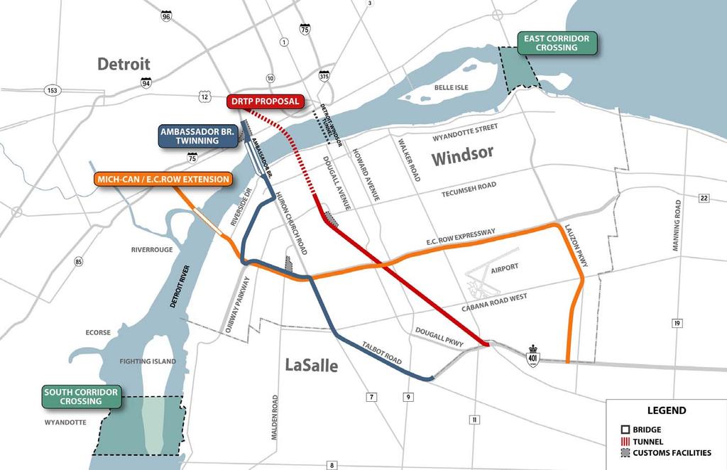
21 Bi-National Alternatives
22 Relative Attractiveness of Alternatives for Trucks Assuming only one new river crossing is built 2010 Volumes * In all other alternatives, other than the twinned Ambassador Bridge, it is assumed that some truck traffic would continue to use the Ambassador Bridge. Source: 2004 Study by the Bi-National Report
23 Relative Attractiveness of Alternatives for Trucks Assuming only one new river crossing is built 2010 Volumes * In all other alternatives, other than the twinned Ambassador Bridge, it is assumed that some truck traffic would continue to use the Ambassador Bridge. Source: 2004 Study by the Bi-National Report

24 Relative Attractiveness of Alternatives for Trucks Assuming only one new river crossing is built 2010 Volumes * In all other alternatives, other than the twinned Ambassador Bridge, it is assumed that some truck traffic would continue to use the Ambassador Bridge. Source: 2004 Study by the Bi-National Report
25 Relative Attractiveness of Alternatives for Trucks Assuming only one new river crossing is built 2010 Volumes * In all other alternatives, other than the twinned Ambassador Bridge, it is assumed that some truck traffic would continue to use the Ambassador Bridge. Source: 2004 Study by the Bi-National Report
26 Relative Attractiveness of Alternatives for Trucks Assuming only one new river crossing is built 2010 Volumes * In all other alternatives, other than the twinned Ambassador Bridge, it is assumed that some truck traffic would continue to use the Ambassador Bridge. Source: 2004 Study by the Bi-National Report

27 Relative Attractiveness of Alternatives for Trucks Assuming only one new river crossing is built 2030 Volumes * In all other alternatives, other than the twinned Ambassador Bridge, it is assumed that some truck traffic would continue to use the Ambassador Bridge. Source: 2004 Study by the Bi-National Report
28 Relative Attractiveness of Alternatives for Trucks Assuming only one new river crossing is built 2030 Volumes * In all other alternatives, other than the twinned Ambassador Bridge, it is assumed that some truck traffic would continue to use the Ambassador Bridge. Source: 2004 Study by the Bi-National Report
29 Relative Attractiveness of Alternatives for Trucks Assuming only one new river crossing is built 2030 Volumes * In all other alternatives, other than the twinned Ambassador Bridge, it is assumed that some truck traffic would continue to use the Ambassador Bridge. Source: 2004 Study by the Bi-National Report
30 Relative Attractiveness of Alternatives for Trucks Assuming only one new river crossing is built 2030 Volumes * In all other alternatives, other than the twinned Ambassador Bridge, it is assumed that some truck traffic would continue to use the Ambassador Bridge. Source: 2004 Study by the Bi-National Report
31 Relative Attractiveness of Alternatives for Trucks Assuming only one new river crossing is built 2030 Volumes * In all other alternatives, other than the twinned Ambassador Bridge, it is assumed that some truck traffic would continue to use the Ambassador Bridge. Source: 2004 Study by the Bi-National Report

32 Relative Attractiveness of Alternatives for Trucks Trucks remaining on Ambassador Bridge 2030 Source: 2004 Study by the Bi-National Report
33 Source: 2004 Study by the Bi-National Report River Width at Crossing Alternatives

34 Source: Bi-National Study 2030 Traffic Level of Service Existing and Proposed Crossings

35 South Crossing Corridor Geography Impacts sensitive marsh habitat and wildlife management program underway on Fighting Island. Impact current residential, institutional and recreational land uses in Wyandotte,Riverview and LaSalle communities. West of river dominated by schools, churches and parks. Approximately 4.2 miles (6.7km) to Interstate 75 from Detroit touchdown site Source: Bi-National Study

36 Central Crossing Corridor Geography New bridge footprint on Canadian and U.S. sides would be in predominately industrial areas with minimum impact to local residences. Approximately 1.3 miles (2 km) to Interstate 75 from Detroit touchdown site Source: Bi-National Study
.")
37 Ambassador Twinning and DRTP Corridor Geography On Canadian side, new bridge would impact Sandwich Town, University of Windsor and downtown Windsor communities. New bridge footprint would be adjacent to residential areas of Mexicantown (Detroit). DRTP connection to I-75 would pass though Corktown Source: Bi-National Study

38 East Crossing Corridor Geography Environmental impacts to Peche Ile or Belle Isle Heavy residential and community impacts in Detroit, Gross Pointe Park and East Riverside Approximately 2 miles (3.12 km) to Interstate 94 from Detroit touchdown site Source: Bi-National Study
39 Bi-National Alternatives Summary South and East Crossings were least attractive: Would draw fewest trucks Wider river crossings Pass through sensitive areas Poor interstate access Significant community issues Fail capacity test Leaving three alternatives for further study: DRTP Central Crossing/ Mich-Can Ambassador Twinning
40 Alternatives - DRTP Single Barreled Rail Tube 2 one lane truck tunnels 200m Residential Impact Zone Customs Plaza 4 New Bridges Non FAST Truck Staging Area 4 New Traffic Signals
 wide and 4.38m (14-4 ) high. Tunnel portion = 2.5 km (1.")
41 Alternatives - DRTP Typical DRTP Truck and Rail Tunnel Cross Section Looking Toward Detroit Truck Tunnel Rail Tunnel Single lane tubes- 4.07m (13-4 ) wide and 4.38m (14-4 ) high. Tunnel portion = 2.5 km (1.6 mi) Base Image - Detroit River Tunnel Project

42 Alternatives - DRTP DRTP Rail Infrastructure Improvements Creation of high clearance tunnel capable of transporting double stacked trailers Compatible with plans for rail rationalization Base Image - Detroit River Tunnel Project

43 Alternatives - DRTP Typical DRTP Truck Tunnel Cross Section looking toward Detroit Cattle Chute Design No Shoulders are provided in Tunnel Base Image - Detroit River Tunnel Project

44 Alternatives - DRTP Profile of DRTP Truckway vs. Street Grade Base Image - Detroit River Tunnel Project

45 Alternatives - DRTP Profile of DRTP Truckway from Dougall Ave to Highway 401

46 Alternatives - DRTP DRTP Rail and Truckway Paths Rail passes under truckway between Tecumseh Road and College Avenue Base Image - Detroit River Tunnel Project
47 Alternatives - DRTP Proposed Section of DRTP truckway Looking towards Detroit Sub-Standard Design: No median shoulders on truckway No median barrier on truckway Base Image - Detroit River Tunnel Project
48 Alternatives - DRTP Standard Cross Section Inside median shoulders and median barrier added

49 Alternatives - DRTP DRTP Section at E.C. Row and Dougall Ave. Interchange
 27m (89 ft.) 34 m (112 ft.")
50 Alternatives - DRTP Comparison of proposed and standard cross-sections 20 m (66 ft.) 27m (89 ft.) 34 m (112 ft.)

51 Alternatives - DRTP Unused Rail Bridge over Dougall Avenue
52 Alternatives - DRTP Dougall Avenue with DRTP Truckway
53 Alternatives - DRTP MaGuire Park - Holburn Street near Cabana Road East

54 Alternatives - DRTP MaGuire Park with proposed Truckway

55 Alternatives - DRTP Assessment Proposed Customs Plaza Noise and air emissions for adjacent residential neighborhoods Concerns due to close proximity of trucks to houses on South Cameron Blvd Base Image - Detroit River Tunnel Project
56 Alternatives - DRTP South Cameron near Totten Street
57 Alternatives - DRTP South Cameron at Totten Street with proposed truckway and rail track

58 Alternatives - DRTP South Cameron at Totten Street with proposed wall

59 Alternatives - DRTP DRTP Connection from EC Row at Dougall Ave. Drawing : Courtesy of Detroit River Tunnel Project


60 Alternatives - DRTP DRTP Connection from EC Row at Dougall Ave. Base Image - Detroit River Tunnel Project

61 Alternatives- DRTP DRTP Connection from EC Row at Dougall Ave. Base Image - Detroit River Tunnel Project
62 Traffic Simulation Files The following traffic simulation videos present these scenarios: DRTP / E.C. Row / Dougall Avenue Interchange DRTP built from river to E.C. Row only, 2015 DRTP built from river to E.C. Row only, 2030 DRTP built to Highway 401, 2030 DRTP / Highway 401 Interchange 2015 Phase 1

63 DRTP Built from River to E.C. Row Only, 2015 E.C. Row / Dougall Avenue/ DRTP Interchange
64 DRTP Built from River to E.C. Row Only, 2030 E.C. Row / Dougall Avenue/ DRTP Interchange

65 DRTP Built to Highway 401, 2030 E.C. Row / Dougall Avenue/ DRTP Interchange

66 Alternatives - DRTP DRTP and Highway 401- Phase 1 Base Image - Detroit River Tunnel Project

67 DRTP / Highway 401 Interchange, 2015 Phase 1

68 2030 Traffic Demand Existing and Proposed Crossings
69 Alternatives Ambassador Twinning and Parkway Two Bridges: 4 Lanes in Each Direction Parkway: 3 Lanes in Each Direction 8 lane section through Sandwich Town Fly-over Ramps at EC Row and 401 Customs Plaza / Staging Area

70 Alternatives Ambassador Twinning and Parkway Looking North down the 10 km Parkway, this illustrates the dedicated proposed Parkway Route from the end of the 401 to E.C. Row with provisions for local access. Image courtesy of Canadian Transit Company

71 Alternatives Ambassador Twinning and Parkway Looking North to Detroit. Under this scheme U.S. Customs would be located in Image plaza area. courtesy of Canadian Transit Company Image courtesy of Canadian Transit Company

72 Alternatives Ambassador Twinning and Parkway Sandwich Towne Air and noise impacts to residents in 200m of CTC Parkway

73 Alternatives- Mich-Can Bridge/E.C. Row Expressway Ext. Image courtesy of Mich-Can International Bridge Company
 southwest of Ambassador Bridge Proposed 2 lanes in each direction Mich-Ca")
74 Alternatives- Mich-Can Bridge/E.C. Row Expressway Ext. Central Crossing located at end of Prospect Avenue Passenger and Commercial vehicles Located 3 km (approximately 1.8 mi) southwest of Ambassador Bridge Proposed 2 lanes in each direction Mich-Can supports the proposed E.C. Row-Lauzon Extension as adequate means for truck access from Highway 401 Image courtesy of Mich-Can International Bridge Company

75 Alternatives- Mich-Can Bridge/E.C. Row Expressway Ext.
76 Crossing Alternatives Conclusion Fully Controlled Access via 401 and EC Row Traffic Impacts on Local Streets Long term use Ambassador Twinning (+) Full control from 401 and EC Row both directions (0) Reduction only in local portions of Huron-Church Rd. and Talbot Rd. (+) 2 added lanes in both directions Sufficient for long term DRTP (-) Fails South bound w/ 3 traffic signals to Highway 401; Fails Northbound in Phase 1 (-) Bottlenecks on Dougall Ave. may cause truck diversion to Ambassador Bridge (-) 1 added lane in each direction for trucks- Insufficient for long term Mich Can/E.C. Row Expressway Extension (0) Full control only from E.C. Row (-) Dependent on a widened E.C Row; Major traffic disruption in Windsor (+) 2 added lanes in both directions Sufficient for long term
77 Crossing Alternatives Conclusion Air and Noise Impacts in 200m Approach Road Width Toll Booth and Customs Impacts Added Redundancy Ambassador Twinning (-) 1372 residences and 33 commercial businesses (-) Six to Eight lanes (+) Proposed Customs Facility in industrial areas at E.C. Row (-) No DRTP (-) 1262 * residences and 82 commercial businesses (+) Two lanes (-) Proposed Customs facility b/t Tecumseh Rd. and Dougall Ave. (0) For trucks only Mich-Can/ E.C. Row Extension (-) 1039 residences, 116 businesses (0) Four lanes (0) Not Defined (+) Yes
78 Crossing Alternatives Conclusion Construction Time Frame Consistency with Community Goals Land Acquisition Ambassador Twinning (0) 4 to 5 years (-) Heavy impact to Sandwich communitynot consistent (-) 8 acquisitions and ROW expenditures needed DRTP (0) 3-4 years (-) Proposed route bisects city of Windsornot consistent (+) Little if any private lands needed for completion Mich-Can/ E.C. Row Extension (0) 3-4 years (-) E.C. Row-Lauzon Ext. would add trucks to the E.C. Row thoroughfare-not consistent (-) 35 acquisitions and ROW expenditures needed
79 Crossing Alternatives Conclusion Summary of Serious Flaws DRTP No added redundancy for cars Poor traffic performance Limited capacity 1262* residences impacted Safety compromised Not fully controlled Significant air and noise impacts adjacent to route Another new crossing would be required Ambassador Bridge-Twinning Lack of redundancy 8 lane highway through Sandwich Towne 6 lane highway along Talbot Road and Huron Church Road 1372 residences impacted Significant air and noise impacts in West Windsor Mich-Can / E.C. Row Extension Dependent on widened E.C. Row to 8-10 lanes & new Lauzon Parkway Extension Major disruption to Windsor traffic Safety compromised 35 ROW takings 1039 residences impacted Significant air and noise impacts adjacent to E.C. Row
80 Crossing Alternatives Conclusion Alternatives must incorporate the following: Consider the long-term objectives and not be reactive Be least intrusive environmentally and socially Consider the impact on existing neighborhoods, preserve the sense of community, and take into consideration proximity to residential, commercial and institutional uses Provide for choice and a flexible integrated transportation network Provide for redundancy Get trucks off city streets Provide controlled access to link to Highway 401 Image courtesy of Canadian Transit Company
81 Crossing Alternatives Conclusion
82 Crossing Alternatives Conclusion Summary of Serious Flaws DRTP No added redundancy for cars Poor traffic performance Limited capacity 1262* residences impacted Safety compromised Not fully controlled Significant air and noise impacts adjacent to route Another new crossing would be required Red = inherent to the crossing itself Ambassador Bridge-Twinning Lack of redundancy 8 lane highway through Sandwich Towne 6 lane highway along Talbot Road and Huron Church Road 1383 residences impacted Significant air and noise impacts in Sandwich Mich-Can / E.C. Row Extension Dependent on widened E.C. Row to 8-10 lanes & new Lauzon Parkway Extension Major disruption to Windsor traffic Safety compromised 35 ROW takings 1039 residences impacted Significant air and noise impacts adjacent to E.C. Row
83 Crossing Alternatives - Recommendations Touchdown location is in industrial areas in the City of Windsor and Detroit Offers Redundancy for all vehicles Narrow river width ( km) negates need for in-water bridge support Draws more commercial truck traffic than other alternatives except for Ambassador Bridge Twinning Adequate capacity for beyond 2030
84 Crossing Alternatives Access Options Goals for Roadways linking Highway 401 and Crossing: Fully controlled access from Highway 401 Minimize number of residences affected Utilize industrial areas to the extent possible Two lanes in each direction Context Sensitive Design Be Employed: Cantilevered roadways and/or tunnels in residential areas Tunneled portions under environmentally sensitive areas Parkettes

85 Crossing Alternatives Roadway Examples Context Sensitive Design Proposed 4-Lane Depressed Cross-Section with Multi-Lane Frontage Road


86 Crossing Alternatives Roadway Examples Context Sensitive Design: Collaborative and interdisciplinary approach to roadway design Reserves residential, aesthetic, historic and environmental resources Grand Central Parkway - New York, NY: Cantilevered service roads preserve residential area


87 Crossing Alternatives Roadway Examples Context Sensitive Design Banff National Park Alberta Culverts and land bridges preserve connectivity between two areas of the park on either side of the Trans-Canada Highway

88 Crossing Alternatives Roadway Examples Context Sensitive Design Porte Sainte Marie - Québec, Canada: Widened bridge structure with planting improves the quality of urban area
89 Roadway Options All road options need to be fully by the public These are schematic drawings and not fully engineered

90 Option1: South Route Tunneled section under residential area 4 lane 2 way expressway Fully controlled from Highway 401
91 Option 2:Central Route A Potential Customs Plaza Protection of Provincial Nature Reserve Tunneled section under residential area
92 Option 3: Central Route B Protection for Provincial Nature Reserve Tunneled section under residential area
93 Option 4: North Route Tunneled section under residential area

94 Options One and Two Roadway Options One and Two bisect LaSalle s Planned Town Center District Image courtesy of Town of LaSalle
95 Windsor Bypass Option 3 - Central Route B is Preferred Option Avoids Town of LaSalle s Proposed Town Center Bypasses Huron Church Road Constructed with few impacts to private property Context Sensitive Design can ameliorate some impact along Talbot Road (tunneled, cantilevered and/or parkettes) Context Sensitive Design can mitigate impact on environmental areas
96 Conclusion A new river crossing is needed by A decision must be made ASAP to meet the target date Overall solution must be multi-modal and balanced and must satisfy demand beyond 2030 This is a multi-billion dollar problem annually; we should not be afraid to THINK BIG Context sensitive design must be used Fast track construction techniques should be considered An early action plan must proceed on ferry, rail and some highway segments to improve access to existing crossings and efficiency and safety of existing network
Windsor Regional Construction Traffic Management System
 Author s Identification Mr. Roger Browne, M.A.Sc., P. Eng. Senior Project Engineer - Advanced Traffic Management Section Ministry of Transportation of Ontario 6th Floor, Building D 1201 Wilson Ave Downsview,
Corporate. Report COUNCIL DATE: June 26, 2006 NO: C012 COUNCIL-IN-COMMITTEE. TO: Mayor & Council DATE: June 22, 2006
 Corporate NO: C012 Report COUNCIL DATE: June 26, 2006 COUNCIL-IN-COMMITTEE TO: Mayor & Council DATE: June 22, 2006 FROM: General Manager, Engineering FILE: 0410-20(MoT/Gate) SUBJECT: Surrey Response on
I-20 ODESSA-MIDLAND CORRIDOR STUDY. Public Meeting for Schematic Design
 I-20 ODESSA-MIDLAND CORRIDOR STUDY Public Meeting for Schematic Design The environmental review, consultation, and other actions required by applicable Federal environmental laws for this project are being,
WEST AND SOUTH WEST RING ROAD DOWNSTREAM TRAFFIC IMPACTS
 Page 1 of 9 EXECUTIVE SUMMARY Alberta Transportation ( AT ) is preparing to construct the final sections of the Calgary Ring Road. This includes the South West Ring Road ( SWRR ) (from Lott Creek Blvd
I-290 Phase I Study Area OAK PARK AVE AUSTIN BLVD. Reconstruction Area (9 miles) Oak Park RIDGELAND AVE CENTRAL AVE HARLEM AVE. Cicero.
 Oak Park RIDGELAND AVE CENTRAL AVE HARLEM AVE. Cicero.") RIDGELAND AVE OAK PARK AVE AUSTIN BLVD UP-RR BRC-RR ASHLAND AVE Study Area Map I-290 Phase I Study Area 294 UP RR Metra UP-W Illinois Prairie Path 38 Berkeley WOLF RD Hillside MANNHEIM RD Bellwood 290
RIDGELAND AVE OAK PARK AVE AUSTIN BLVD UP-RR BRC-RR ASHLAND AVE Study Area Map I-290 Phase I Study Area 294 UP RR Metra UP-W Illinois Prairie Path 38 Berkeley WOLF RD Hillside MANNHEIM RD Bellwood 290
Vision: Traditional hamlet with an attractive business/pedestrian friendly main street connected to adjacent walkable neighborhoods
 N D. Focus Area II Vision: Traditional hamlet with an attractive business/pedestrian friendly main street connected to adjacent walkable neighborhoods Transit Road Focus Area II is located in the Hamlet
Welcome to the Open House
 Leslie Street Between 19 th Avenue and Stouffville Road Addendum to Class Environmental Assessment Study Welcome to the Open House Please sign in at the front desk. March 28, 2017 Richmond Green Sports
Corridor Advisory Group and Task Force Meeting #10. July 27, 2011
 Corridor Advisory Group and Task Force Meeting #10 July 27, 2011 1 Agenda Recap CAG/TF #9 Public Meeting #2 Summary Single Mode Alternatives Evaluation Results Next Steps 2 3 CAG/TF #9 Recap CAG /TF #9
Chapter 5 Future Transportation
 Chapter 5 Future Transportation The Future Land Use Plan identifies the desired land use designations. The land uses desired for Crozet depend, in large part, on the success of the transportation system,
North Coast Corridor:
 North Coast Corridor: Connecting People, Transportation & Environment Legislative Hearing: 11.8.10 1 North Coast Corridor Region s Lifeline A Regional Strategy Mobility, Economy & Environment North Coast
Transportation Master Plan Advisory Task Force
 Transportation Master Plan Advisory Task Force Network Alternatives & Phasing Strategy February 2016 BACKGROUND Table of Contents BACKGROUND Purpose & Introduction 2 Linking the TMP to Key Council Approved
Tonight is an opportunity to learn about the Study and ask questions of the Study Team members.
 Exhibit 1 Welcome Second Open House Tonight is an opportunity to learn about the Study and ask questions of the Study Team members. A first Public Open House was held on September 18th, 2013 which presented
Maywood Town Hall Meeting. May 4, 2016
 Maywood Town Hall Meeting May 4, 2016 1 AGENDA Overall I-290 Study Background Maywood Advisory Working Group (AWG) findings to date Noise Wall Update Next Steps 2 Questions? Study team members also available
APPENDIX G: INTERSECTION NEEDS AT OKEECHOBEE BOULEVARD
 APPENDIX G: INTERSECTION NEEDS AT OKEECHOBEE BOULEVARD INTERSECTION NEEDS AT SR 7 and OKEECHOBEE BOULEVARD SR 7 Extension Project Development and Environment (PD&E) Study From Okeechobee Boulevard (SR
City of Homewood Transportation Plan
 City of Homewood Transportation Plan Prepared for: City of Homewood, Alabama Prepared by: Skipper Consulting, Inc. May 2007 TABLE OF CONTENTS INTRODUCTION... 1 BACKGROUND INFORMATION... 1 EXISTING TRANSPORTATION
INNER LOOP EAST. AIA Rochester Annual Meeting November 13, 2013 TRANSFORMATION PROJECT. Bret Garwood, NBD Erik Frisch, DES
 INNER LOOP EAST TRANSFORMATION PROJECT AIA Rochester Annual Meeting November 13, 2013 Bret Garwood, NBD Erik Frisch, DES Why? We are building a city that encourages walking, biking and enjoying the outdoor
Southbend to Prima Vista. October 30, Floresta Corridor Master Plan
 Application of a Complete Street initiative and how it might function operationally 8 8 Southbend to Prima Vista October 30, 2017 Presentation Agenda 2 Perspective and History Traffic projections, Levels
Exhibit 1 PLANNING COMMISSION AGENDA ITEM
 Exhibit 1 PLANNING COMMISSION AGENDA ITEM Project Name: Grand Junction Circulation Plan Grand Junction Complete Streets Policy Applicant: City of Grand Junction Representative: David Thornton Address:
Welcome. Thank you for your interest in the Lewis & Clark Viaduct Concept Study
 Welcome Thank you for your interest in the Lewis & Clark Viaduct Concept Study Please use the arrows in the upper left hand corner to navigate through the presentation. Use the envelope icon to ask a question
State Road 54/56 Tampa Bay s Northern Loop. The Managed Lane Solution Linking I-75 to the Suncoast Parkway
 State Road 54/56 Tampa Bay s Northern Loop The Managed Lane Solution Linking I-75 to the Suncoast Parkway SUNCOAST PARKWAY Both I 75 and the Suncoast Parkway are planning, or in the process of constructing,
Alberta Infrastructure HIGHWAY GEOMETRIC DESIGN GUIDE AUGUST 1999
 Alberta Infrastructure HIGHWAY GEOMETRIC DESIGN GUIDE AUGUST 1999,1'(; A ACCELERATION Data on acceleration from stop D-29 Effects of grade D-35 Intersections D-97, D-99 Lanes D-97, F-5, F-7, F-15, F-21,
Terwillegar Drive Expressway Draft Concept Plan
 Terwillegar Drive Expressway Draft Concept Plan Anthony Henday Drive to Whitemud Drive November 28 5:00-8:00 p.m. December 1 10:00 a.m. - 3:00 p.m. Let s Talk Today you can: Learn about the new direction
Environmental Assessment Findings & Recommendations. Public Hearing November 13, 2014
 Environmental Assessment Findings & Recommendations Public Hearing November 13, 2014 Welcome! Welcome and Introductions Project and Environmental Assessment Overview Public Comments Adjourn Purpose of
Frequently Asked Questions (FAQ)
") Frequently Asked s (FAQ) Study Process... 2 Rapid Transit Service and Operations... 5 Public Consultation... 8 Business Impacts... 8 Design and Property Impacts... 9 Construction Impacts...12 Traffic,
Frequently Asked s (FAQ) Study Process... 2 Rapid Transit Service and Operations... 5 Public Consultation... 8 Business Impacts... 8 Design and Property Impacts... 9 Construction Impacts...12 Traffic,
Tonight is for you. Learn everything you can. Share all your ideas.
 Strathcona Neighbourhood Renewal Draft Concept Design Tonight is for you. Learn everything you can. Share all your ideas. What is Neighbourhood Renewal? Creating a design with you for your neighbourhood.
Managed Lanes. Steve Schilke, P.E. Major Projects Unit Head District 1. Illinois Traffic Engineering and Safety Conference October 2016
 Managed Lanes Steve Schilke, P.E. Major Projects Unit Head District 1 Illinois Traffic Engineering and Safety Conference October 2016 Agenda Managed Lanes Projects I-55 (Stevenson Expressway) Express Toll
STREET AND HIGHWAY PLAN
 STREET AND HIGHWAY PLAN Introduction The street and highway system in the Winston-Salem Urban Area consists of thousands of miles of traffic carrying facilities, ranging from short local residential streets
WELCOME TO OPEN HOUSE # 1 June 14, 2017
 Langstaff Road Weston Road to Highway 7 Class Environmental Assessment Study WELCOME TO OPEN HOUSE # 1 June 14, 2017 Please sign in and join our mailing list Purpose of Open House #1 & Study Area York
Welcome to the McKenzie Interchange Project Open House!
 Welcome to the McKenzie Interchange Project Open House! Purpose of Open House To provide you with information regarding the project and for you to have the opportunity to share your input on design concepts.
Giles Run Connector Road
 Giles Run Connector Road Laurel Hill Adaptive Reuse Area to Laurel Crest Drive South County Federation Meeting June 14, 2016 History Connector road included in the Laurel Hill Comprehensive Plan amendment
APPENDIX 2 LAKESHORE ROAD TRANSPORTATION REVIEW STUDY EXECUTIVE SUMMARY
 APPENDIX 2 LAKESHORE ROAD TRANSPORTATION REVIEW STUDY EXECUTIVE SUMMARY Appendix 2 City of Mississauga Lakeshore Road FINAL REPORT Transportation Review Study December 2010 EXECUTIVE SUMMARY Study Purpose
TRANSPORTATION NEEDS ASSESSMENT
 TRANSPORTATION NEEDS ASSESSMENT A travel demand analysis was carried out to determine the operational issues and the potential benefit that adding traffic capacity would have on the road network. All the
DUNBOW ROAD FUNCTIONAL PLANNING
 DUNBOW ROAD FUNCTIONAL PLANNING Final Report August 3, 216 #31, 316 5th Avenue NE Calgary, AB T2A 6K4 Phone: 43.273.91 Fax: 43.273.344 wattconsultinggroup.com Dunbow Road Functional Planning Final Report
Downtown BRT Corridor Alternatives Review: 1 st, 2 nd, 3 rd and 4 th Avenue. Bus Rapid and Conventional Transit Planning and Design Services
 Downtown BRT Corridor Alternatives Review: 1 st, 2 nd, 3 rd and 4 th Avenue Bus Rapid and Conventional Transit Planning and Design Services City of Saskatoon February 2018 Project Team HDR Corporation
5 CIRCULATION AND STREET DESIGN
 5 CIRCULATION AND STREET DESIGN This chapter describes circulation and streetscape improvements proposed for the Northwest Chico Specific Plan Area. It includes detailed design specifications for existing
APPENDIX D. May 22, 2002 Open House Summary and Materials
 APPENDIX D May 22, 2002 Open House Summary and Materials TH 36 Partnership Study Open House May 22, 2002 Summary of Survey Responses 1. If no new crossing of the St. Croix River is built (e.g. the existing
CONNECTIVITY PLAN. Adopted December 5, 2017 City of Virginia Beach
 CONNECTIVITY PLAN Adopted December 5, 2017 City of Virginia Beach CONTENTS 1.0 Background & Purpose... 2 2.0 Existing Inventory & Analysis... 3 ViBe District Existing Walking Conditions... 4 3.0 ViBe District
6.0 PEDESTRIAN AND BICYCLE FACILITIES 6.1 INTRODUCTION 6.2 BICYCLE DEMAND AND SUITABILITY Bicycle Demand
 6.0 PEDESTRIAN AND BICYCLE FACILITIES 6.1 INTRODUCTION Bicycle and pedestrian travel along and in the vicinity of the corridor is part of the vision of Somerset and Hunterdon counties and the integrated
Congestion Management Report
 Congestion Management Report F.E. EVERETT TURNPIKE (NORTH), MERRIMACK Segment Length: 7.0 miles Daily Traffic Volumes: 60,000-69,000 Analysis Period: May 2015 Number of Traffic Signals: 0 Number of travel
City of Novi Non-Motorized Master Plan 2011 Executive Summary
 City of Novi Non-Motorized Master Plan 2011 Executive Summary Prepared by: February 28, 2011 Why Plan? Encouraging healthy, active lifestyles through pathway and sidewalk connectivity has been a focus
Municipal Class EA To Address Traffic Congestion On The Ontario Street Corridor (Grand Bend) Public Information Meeting June 4, 2018
 Public Information Meeting June 4, 2018") Municipal Class EA To Address Traffic Congestion On The Ontario Street Corridor (Grand Bend) Public Information Meeting June 4, 2018 Background Agenda Traffic Study Update Class EA Alternatives Bridge
Municipal Class EA To Address Traffic Congestion On The Ontario Street Corridor (Grand Bend) Public Information Meeting June 4, 2018 Background Agenda Traffic Study Update Class EA Alternatives Bridge
Main-McVay Transit Study: Phase 2 Options Definition and High Level Constraints Evaluation
 Main-McVay Transit Study: Phase 2 Options Definition and High Level Constraints Evaluation APRIL 2016 A collaborative study between: For Additional Information or to Comment If you would like additional
Arterial Management Plan for US Route 250 and State Route 623
 Arterial Management Plan for US Route 250 and State Route 623 June 25, 2014 Brad Shelton, AICP Access Management and Traffic Impact Analysis Programs Manager Transportation and Mobility Planning Division
City of Hamilton s Transportation Master Plan (TMP) Public Consultation 3 December 2015
 Public Consultation 3 December 2015") City of Hamilton s Transportation Master Plan (TMP) Public Consultation 3 December 2015 McPhail Transportation Planning Services Ltd. AGENDA 6:00 7:00 pm Viewing Boards / Q & A with the Team 7:00 7:50
City of Hamilton s Transportation Master Plan (TMP) Public Consultation 3 December 2015 McPhail Transportation Planning Services Ltd. AGENDA 6:00 7:00 pm Viewing Boards / Q & A with the Team 7:00 7:50
Brian McHugh, Buckhead Community Improvement District. SUBJECT: Wieuca Road at Phipps Boulevard Intersection Improvements Project
 MEMO TO: FROM: Brian McHugh, Buckhead Community Improvement District Jagan Kaja, AICP, WSP Parsons Brinckerhoff SUBJECT: Wieuca Road at Phipps Boulevard Intersection Improvements Project DATE: October
Alberta Highway 881. Corridor Management Plan. Session Forum 1 - Highways. Tri-Party Transportation Conference Moving Alberta Into the Future
 Tri-Party Transportation Conference Moving Alberta Into the Future Alberta Highway 881 Corridor Management Plan Lac La Biche to Anzac Session Forum 1 - Highways March 2017 INTRODUCTION + 241 km long, 2
HIGHBURY AVENUE/HAMILTON ROAD INTERSECTION IMPROVEMENTS PUBLIC INFORMATION CENTRE 1 MAY 14, 2015
 HIGHBURY AVENUE/HAMILTON ROAD INTERSECTION IMPROVEMENTS Municipal Class Environmental Assessment PUBLIC INFORMATION CENTRE 1 MAY 14, 2015 ACCESSIBILITY Under the Accessibility Standards 2015 for Customer
Appendix C. NORTH METRO STATION AREA TRAFFIC IMPACT STATEMENT 88th Avenue Station
 Appendix C NORTH METRO STATION AREA TRAFFIC IMPACT STATEMENT 88th Avenue Station Prepared for: Regional Transportation Department and URS Corporation as part of the North Metro EIS David Evans and Associates,
NEWMARKET UPHAM S CORNER
 SOUTH STATION Planning Initiative NEWMARKET UPHAM S CORNER COLUMBIA ROAD (P) FOUR CORNERS/GENEVA Working Advisory Group (WAG) Meeting #5 TALBOT AVENUE MORTON STREET BLUE HILL AVE/CUMMINS HWY (P) RIVER
Golden s Plan. For the Highway 6 & 93 Corridor
 Golden s Plan For the Highway 6 & 93 Corridor Purpose of the Study Accommodate regional traffic needs on Highways 6 and 93, as defined by the Northwest Quadrant Feasibility Study. Find a solution that
Operational Comparison of Transit Signal Priority Strategies
 Operational Comparison of Transit Signal Priority Strategies Revision Submitted on: November, 0 Author: Adriana Rodriguez, E.I Assistant Engineer Parsons Brinckerhoff 0 South Orange Avenue, Suite 00 Orlando,
McKenzie Interchange Project Spring 2016 Comment Period. Appendix 1: Display Boards and Feedback Form
 McKenzie Interchange Project Spring 2016 Comment Period Appendix 1: Display Boards and Feedback Form August 2016 Welcome to the McKenzie Interchange Project Information Session! Purpose of this Information
Multi Modal Transit Access Plan KIPDA ID # 239. Project Type: STUDY
 Multi Modal Transit Access Plan KIPDA ID # 239 Project Type: STUDY Description: In conjunction with the results from Project Gobility and the Transit LOS Analysis, TARC seeks to examine the possibilities
ROADSOADS CONGESTION HAMPTON SYSTEMYSTEM MANAGEMENT. Part II Roadway Congestion Analysis Mitigation Strategies and Evaluation
 HAMPTON ROADSOADS CONGESTION MANAGEMENT SYSTEMYSTEM Part II Roadway Congestion Analysis Mitigation Strategies and Evaluation Presented by: Dwight Farmer, PE Deputy Executive Director, Transportation April
BETHEL ROAD AND SEDGWICK ROAD CORRIDOR STUDY
 DRAFT PLAN City Council Meeting August 14, 2017 STUDY AREA Sedgwick Corridor State Route 160, principal arterial with Class 3 access management designation, commuter and freight route, connection to SR
ROUTES 55 / 42 / 676 BUS RAPID TRANSIT LOCALLY PREFERRED ALTERNATIVE
 ROUTES 55 / 42 / 676 BUS RAPID TRANSIT LOCALLY PREFERRED ALTERNATIVE April, 2012 1 INTRODUCTION The need for transit service improvements in the Routes 42/55/676 corridor was identified during the Southern
Providence Downtown Transit Connector STAKEHOLDER MEETING #2. Stakeholder Meeting #1 October 24, 2016
 Providence Downtown Transit Connector STAKEHOLDER MEETING #2 Stakeholder Meeting #1 October 24, 2016 February 2017 1 AGENDA 1 DTC Goals and Expectations 2 Street Design Concepts 3 Potential Benefits and
EXECUTIVE SUMMARY... vii 1 STUDY OVERVIEW Study Scope Study Area Study Objectives
 Contents EXECUTIVE SUMMARY... vii 1 STUDY OVERVIEW... 1-1 1.1 Study Scope... 1-1 1.2 Study Area... 1-1 1.3 Study Objectives... 1-3 2 EXISTING CONDITIONS... 2-1 2.1 Existing Freeway Conditions... 2-4 2.1.1
Access Management Regulations and Standards
 Access Management Regulations and Standards January 2014 Efficient highway operation Reasonable property access Concept of Access Management The way to manage access to land development while preserving
San Jose Transportation Policy
 San Jose Transportation Policy Protected Intersections in LOS Policies to Support Smart Growth Presented by: Manuel Pineda City of San Jose Department of Transportation Bay Area Map San Francisco Oakland
DON MILLS-EGLINTON Mobility Hub Profile
 Mobility Hub Profile Dundas Don Mills-Eglinton West-Bloor Anchor Hub Gateway Hub N MOBILITY HUBS: Places of connectivity between regional and rapid transit services, where different modes of transportation
PREFERRED ALTERNATIVE IMPLEMENTATION PLAN. Prepared for. Ohio Department of Transportation, District South SR 741 Lebanon, Ohio 45036
 HAM-32F-0.00 PID 86461 PREFERRED ALTERNATIVE IMPLEMENTATION PLAN Prepared for Ohio Department of Transportation, District 8 505 South SR 741 Lebanon, Ohio 45036 Prepared by URS Corporation 564 White Pond
Planning Study SR 976. Project Advisory Team Meeting May 24, 2017
 ` SR 976 BIRD ROAD/SW 40TH STREET FROM SR 821/HEFT TO SR 5/US-1 Miami-Dade County, Florida FPID No.: 434845-4-22-01 Planning Study Project Advisory Team Meeting May 24, 2017 1 Agenda Introductions Project
City of Wayzata Comprehensive Plan 2030 Transportation Chapter: Appendix A
 A1. Functional Classification Table A-1 illustrates the Metropolitan Council s detailed criteria established for the functional classification of roadways within the Twin Cities Metropolitan Area. Table
Recommended Roadway Plan Section 2 - Land Development and Roadway Access
 Recommended Roadway Plan Section 2 - Land Development and Roadway Access SECTION 2 Land Development and Roadway Access 2.1 Land Use and Access Management The Federal Highway Administration (FHWA) defines
Public Event 1 Community Workshops
 Public Event 1 Community Workshops Nov. 24 & Dec. 3, 2016 Welcome Workshop Purpose We re looking to you for ideas and insights to help guide future transportation infrastructure planning in the Park Lawn
4 DISRUPTION MANAGEMENT PLAN HIGHWAY 7 RAPIDWAY CONSTRUCTION BETWEEN BAYVIEW AVENUE AND WARDEN AVENUE TOWNS OF MARKHAM AND RICHMOND HILL
 4 DISRUPTION MANAGEMENT PLAN HIGHWAY 7 RAPIDWAY CONSTRUCTION BETWEEN BAYVIEW AVENUE AND WARDEN AVENUE TOWNS OF MARKHAM AND RICHMOND HILL The Transportation Services Committee recommends the adoption of
Circulation in Elk Grove includes: Motor vehicles, including cars and trucks
 Circulation, as it is used in this General Plan, refers to the many ways people and goods move from place to place in Elk Grove and the region. Circulation in Elk Grove includes: Motor vehicles, including
City of Windsor RIVERSIDE DRIVE VISTA IMPROVEMENT PROJECT. Class Environmental Assessment
 DSR wt C/SSR wt I/B C/SSR wt DSR wt DSR C/DSR I/B C/SSR C/B/E C/SSR C/SSR 35 Character Type Predominant Land Use Typical Riverside Drive Cross-Section Extent Civic / Single Sided Residential C/SSR Public
Regional Transportation Needs Within Southeastern Wisconsin
 Regional Transportation Needs Within Southeastern Wisconsin #118274 May 24, 2006 1 Introduction The Southeastern Wisconsin Regional Planning Commission (SEWRPC) is the official areawide planning agency
McKenzie Interchange Project Fall 2015 Engagement. Appendix 2: Engagement Materials and Feedback Form
 Fall 2015 Engagement Appendix 2: Engagement Materials and Feedback Form Welcome to the McKenzie Interchange Project Open House! Purpose of Open House To provide you with information regarding the project
Portland International Airport Bicycle and Pedestrian Plan (October 2003) Staff Acknowledgements
 Staff Acknowledgements") Portland International Airport Bicycle and Pedestrian Plan (October 2003) Staff Acknowledgements Scott King, Senior Aviation Planner Jason Gately, Senior Aviation Planner Preston Beck, Associate Planner
Portland International Airport Bicycle and Pedestrian Plan (October 2003) Staff Acknowledgements Scott King, Senior Aviation Planner Jason Gately, Senior Aviation Planner Preston Beck, Associate Planner
City of Moorhead Committee of the Whole Meeting
 City of Moorhead Committee of the Whole Meeting Corridor Study Limits Center Avenue (Red River to 8th Street) TH 10 (Red River to TH 336) TH 75 (20th Ave S to Main Avenue) 2 Study Need: Project Overview
FONTAINE AVENUE STUDY Final Report
 FONTAINE AVENUE STUDY Final Report March 28, 2005 FONTAINE AVENUE STUDY City of Charlottesville March 28, 2005 Renaissance Planning Group Kenneth Schwartz, FAIA, AICP Director of Design Leigh Wilkerson,
JONESBORO HIGHWAY 63 HIGHWAY 18 CONNECTOR STUDY
 JONESBORO HIGHWAY 63 HIGHWAY 18 CONNECTOR STUDY Craighead County May 2007 JONESBORO HIGHWAY 63 HIGHWAY 18 CONNECTOR STUDY Craighead County May 2007 Prepared by Planning and Research Division Arkansas State
CITY OF SEATTLE RESOLUTION. WHEREAS, the Washington State Department of Transportation (WSDOT) led the Seattle
 led the Seattle") SDOT SR0 Design Refinements RES August, 0 Version #D 0 CITY OF SEATTLE RESOLUTION..title A RESOLUTION relating to the State Route 0, Interstate to Medina Bridge Replacement and High Occupancy Vehicle Project;
SDOT SR0 Design Refinements RES August, 0 Version #D 0 CITY OF SEATTLE RESOLUTION..title A RESOLUTION relating to the State Route 0, Interstate to Medina Bridge Replacement and High Occupancy Vehicle Project;
REPORT CONCURRENCE. City Manager. The General Manager concurs with the recommendation of this report.
 COUNCIL REPORT Report No. ENG 08-018 Executive Committee Date: May 0, 018 File No: 5400-1 To: From: Subject: Mayor and Council Purvez Irani, Senior Transportation Engineer Bluejay Street Road Improvements
York Region Population and Employment Growth
 March 1, 2016 1 York Region Population and Employment Growth York Region needs to comply with The Provincial Growth Plan and new forecasts introduced to 2036 and 2041 2 Regional Official Plan Review York
10.0 CURB EXTENSIONS GUIDELINE
 10.0 CURB EXTENSIONS GUIDELINE Road Engineering Design Guidelines Version 1.0 March 2017 City of Toronto, Transportation Services City of Toronto Page 0 Background In early 2014, Transportation Services
Corpus Christi Metropolitan Transportation Plan Fiscal Year Introduction:
 Introduction: The Safe, Accountable, Flexible, Efficient Transportation Equity Act: A Legacy for Users (SAFETEA-LU) has continued the efforts started through the Intermodal Surface Transportation Efficiency
EXECUTIVE SUMMARY OF CALEDON TRANSPORTATION NEEDS STUDY
 EXECUTIVE SUMMARY OF CALEDON TRANSPORTATION NEEDS STUDY The Caledon Transportation Needs Study has been undertaken as a joint project by the Town of Caledon and the Region of Peel to determine the existing
FM #: ETDM #: 11241
 SR 826/Palmetto Expressway PD&E Study From SR 93/I 75 to the Golden Glades Interchange FM #: 418423 1 22 01 ETDM #: 11241 Agency/ Kick Off Meeting October 27, 2011 2 Location Map From SR 93/I 75 to Golden
Highway 49, Highway 351 and Highway 91 Improvements Feasibility Study Craighead County
 Highway 49, Highway 351 and Highway 91 Improvements Feasibility Study Craighead County Executive Summary March 2015 Highway 49, Highway 351 and Highway 91 Improvements Feasibility Study Craighead County
WELCOME. Stakeholder Involvement Group Meeting #2 Round Lake Public Works October 24, 2018
 WELCOME Stakeholder Involvement Group Meeting #2 Round Lake Public Works October 24, 2018 MEETING AGENDA 1. Welcome and Introductions 2. Study Progress Update 3. Problem Statement 4. Technical Analysis
Highway 56 Traffic Study Rymal Road to Cemetery Road
 January 31, 2018 6:00 pm 8:00 pm Highway 56 Traffic Study Rymal Road to Cemetery Road City of Hamilton Public Meeting 2 2 Purpose of Public Meeting To review and obtain public input and comments on the
HARRISON STREET/OAKLAND AVENUE COMMUNITY TRANSPORTATION PLAN
 HARRISON STREET/OAKLAND AVENUE Community Workshop #4: Draft Plan Review December 3, 2009 D E S I G N, C O M M U N I T Y & E N V I R O N M E N T INTRODUCTIONS Key Project Staff: Alisa Shen, Project Manager,
CITY OF VAUGHAN EXTRACT FROM COUNCIL MEETING MINUTES OF OCTOBER 30, 2012
 CITY OF VAUGHAN EXTRACT FROM COUNCIL MEETING MINUTES OF OCTOBER 30, 2012 Item 31, Report No. 39, of the Committee of the Whole, which was adopted without amendment by the Council of the City of Vaughan
Clackamas County Comprehensive Plan
 ROADWAYS The County s road system permits the movement of goods and people between communities and regions, using any of a variety of modes of travel. Roads provide access to virtually all property. They
2. Context. Existing framework. The context. The challenge. Transport Strategy
 Transport Strategy Providing quality connections Contents 1. Introduction 2. Context 3. Long-term direction 4. Three-year priorities 5. Strategy tree Wellington City Council July 2006 1. Introduction Wellington
ENHANCED PARKWAY STUDY: PHASE 2 CONTINUOUS FLOW INTERSECTIONS. Final Report
 Preparedby: ENHANCED PARKWAY STUDY: PHASE 2 CONTINUOUS FLOW INTERSECTIONS Final Report Prepared for Maricopa County Department of Transportation Prepared by TABLE OF CONTENTS Page EXECUTIVE SUMMARY ES-1
RESOLUTION NO ?? A RESOLUTION OF THE CITY OF NEPTUNE BEACH ADOPTING A COMPLETE STREETS POLICY
 RESOLUTION NO. 2018-?? A RESOLUTION OF THE CITY OF NEPTUNE BEACH ADOPTING A COMPLETE STREETS POLICY WHEREAS, safe, convenient, and accessible transportation for all users is a priority of the City of Neptune
In station areas, new pedestrian links can increase network connectivity and provide direct access to stations.
 The Last Mile Planning for Pedestrians Planning around stations will put pedestrians first. Making walking to stations safe and easy is important; walking will be a part of every rapid transit Accessible
Building a Liveable Ottawa 2031 Backgrounder 5: Barrhaven/Riverside South/Leitrim
 Building a Liveable Ottawa 2031 Backgrounder 5: Barrhaven/Riverside South/Leitrim Wards 3 and 22 Official Plan Transportation Master Plan Cycling Plan Pedestrian Plan October 2013 ottawa.ca/liveableottawa
GOAL 2A: ESTABLISH AND MAINTAIN A SAFE, CONVENIENT, AND EFFICIENT MULTI-MODAL TRANSPORTATION SYSTEM TO MOVE PEOPLE AND GOODS THROUGHOUT THE CITY.
 2. TRANSPORTATION ELEMENT The purpose of this element is to assist in establishing an adequate transportation system within the City and to plan for future motorized and non-motorized traffic circulation
Fitting Light Rail through Well-established Communities
 Fitting Light Rail through Well-established Communities San Francisco 2008 Michael D. Madden Chief, Project Development, Maryland Transit Administration Project Setting Located inside the Capital Beltway
M-58 HIGHWAY ACCESS MANAGEMENT STUDY Mullen Road to Bel-Ray Boulevard. Prepared for CITY OF BELTON. May 2016
 M-58 HIGHWAY ACCESS MANAGEMENT STUDY Prepared for CITY OF BELTON By May 2016 Introduction Missouri State Highway 58 (M-58 Highway) is a major commercial corridor in the City of Belton. As development has
Northbound San Jose Avenue & I-280 Off-Ramp Road Diet Pilot Project
 Project Overview Fed by a two-lane Interstate-280 (I-280) off-ramp, high vehicular volumes and speeds are longstanding issues along San Jose Avenue. Residents in the surrounding neighborhoods have expressed
ARTINSVILLE ENRY OUNTY REA RANSPORTATION TUDY
 ARTINSVILLE ENRY OUNTY REA RANSPORTATION TUDY DEVELOPED BY THE TRANSPORTATION AND MOBILITY PLANNING DIVISION OF THE VIRGINIA DEPARTMENT OF TRANSPORTATION IN COOPERATION WITH THE U.S. DEPARTMENT OF TRANSPORTATION,
Southwest Bus Rapid Transit (SW BRT) Functional Planning Study - Executive Summary January 19 LPT ATTACHMENT 2.
 Functional Planning Study - Executive Summary January 19 LPT ATTACHMENT 2.") Southwest Bus Rapid Transit (SW BRT) Functional Planning Study - Executive Summary 2011 January 19 1 of 19 Introduction This executive summary presents the results of the Southwest Bus Rapid Transit (SW
Southwest Bus Rapid Transit (SW BRT) Functional Planning Study - Executive Summary 2011 January 19 1 of 19 Introduction This executive summary presents the results of the Southwest Bus Rapid Transit (SW
4. ENVIRONMENTAL IMPACT ANALYSIS 9. TRANSPORTATION AND TRAFFIC
 4. ENVIRONMENTAL IMPACT ANALYSIS 9. TRANSPORTATION AND TRAFFIC 4.9.1 INTRODUCTION The following section addresses the Proposed Project s impact on transportation and traffic based on the Traffic Study