INSTANT IMPACT GUIDE TEMPORARY, COST-EFFECTIVE IDEAS FOR MORE VIBRANT STREETS
|
|
|
- Eustace Lloyd
- 5 years ago
- Views:
Transcription


1 INSTANT IMPACT GUIDE TEMPORARY, COST-EFFECTIVE IDEAS FOR MORE VIBRANT STREETS


2 2
3 TABLE OF CONTENTS The Houston-Galveston Area Council (H-GAC) is the voluntary association of local governments in the 13-county Gulf Coast Planning region of Texas. H-GAC also serves as the Metropolitan Planning Organization (MPO) for the eight-county Houston- Galveston area. Houston-Galveston Area Council 3555 Timmons Lane Houston, TX The preparation of this document has been financed in part through grants from the Federal Highway Administration and the Federal Transit Administration, U.S. Department of Transportation, under the Metropolitan Planning Program, Section 104(f) of Title 23, U.S. Code. The contents of this document do not necessarily reflect the official views or policy of the U.S. Department of Transportation. 4 Introduction 6 How to Do It 8 Toolbox 12 Spotlight on... Houston s Washington Avenue 14 Spotlight on... Memphis Better Block 15 Spotlight on... Houston Park(ing) Day 16 Additional Resources 18 Image Credits 3


4 INTRODUCTION Creating a pedestrian- and bicycle-friendly streetscape can make a community more vibrant, attracting new residents, businesses, and investments. This guide offers information on quick, temporary, low-cost projects that can help create active, walkable, and bikeable streets. These instant impact projects can be initiated and implemented by volunteers, community groups, and local governments. WHY IT S GOOD Creating a high-quality environment for pedestrians and bicyclists can take time. Resources for new infrastructure, such as sidewalks and bikeways, may not be readily available. Instant impact projects can help build momentum by increasing public awareness and support. They are also a good way to test new ideas before designs and policies are finalized. Image: SWA 4 Image: SWA


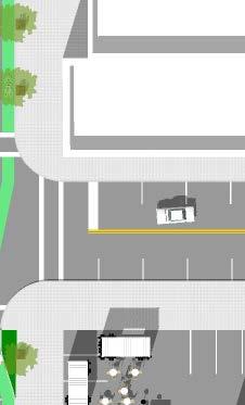
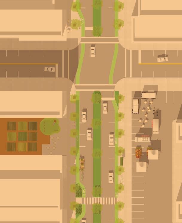
5 Instant impact projects are implemented by community volunteers and/or local governments. They use provisional, low-cost materials to temporarily transform an under-performing street into a charming place, attracting pedestrians, cyclists, and other visitors of all ages and abilities: Temporary bike lanes make cycling comfortable. Potted trees shade pedestrians and beautify the corridor. Farmers markets, food truck lots, and pop-up cafes attract shoppers. Artificial turf medians slow vehicular traffic, increasing safety for pedestrians. Community gardens installed in vacant lots draw nearby residents. WHAT IS... WHAT COULD BE... Streets are often designed to maximize the speed and number of cars moving through, making them uncomfortable for pedestrians and cyclists. Poorly maintained or nonexistent sidewalks, wide streets, vacant buildings, and large parking lots discourage people from walking, biking, and spending time in an area. 5


 Assemble the Project Team Extend an invitation to the community businesses, property owners, residents, local governments, and community groups to lead and participate in the planning and")
6 HOW TO DO IT Instant impact projects can be planned on a short timeline (about three months) and a low budget (less than $1,500). This step-by-step guide offers ideas for planning an instant impact one-day event. MAKE A PLAN 1) Identify the Area An optimal area for an instant impact project has buildings near the street, ideally with no space between the building and the sidewalk, regardless of the condition of the storefronts. An area with large parking lots or vacant lots lining the street can also work. A street with existing sidewalks is a plus. To maximize limited resources, set a clear project boundary. Also, consider places with active community organizations and property owners willing to participate. 2) Assemble the Project Team Extend an invitation to the community businesses, property owners, residents, local governments, and community groups to lead and participate in the planning and implementation of an instant impact project. Target property owners and local community groups, including volunteer groups, churches, civic organizations, and Chambers of Commerce. 3) Visualize the Project Take the project team on a tour of the area to gather ideas and identify strengths and weaknesses. Document existing conditions and visualize what the area could look like. Choose a date for the project and outline a project timeline. 6 Image: SWA 4) Advertise Advertise the project and the day of the event. Promote the event on social media and other marketing outlets. Be sure to provide updates as the project evolves.


7 MAKE A DESIGN 5) Create a Design Concept Create the design plan based on ideas collected during the area tour. Tips for creating the design: Keep the design simple to maintain a low budget and short timeline. See the Toolbox beginning on Page 8 for potential project elements. Align participants skills and strengths with different elements of the project. Though not necessary, consider closing at least one lane of traffic and some parking to accommodate the instant impact project. However, be sure to not completely shut down the street. A primary reason for instant impact projects is to demonstrate that everyone bicyclists, pedestrians, and motorists can simultaneously share the right-of-way. Do not forget basic essentials and important items like port-a-lets and electrical needs. Obtain necessary permits and approvals from the city or county. MAKE IT HAPPEN 7) Install the Project Build the project. The instant impact project team should be in charge of setup. Block off a lane of traffic for pedestrians and bicyclists. Place planters and benches along the street or sidewalk. Roll out the artificial turf median. Paint crosswalks and bike lanes. Help local vendors set up shop. 8) Measure Success Survey event participants, record pedestrian and bicyclist counts, monitor traffic and traffic speeds, and gather information on retail sales. These metrics will provide data to support long-term improvements. 9) Wrap Up Most of the instant impact project components could remain indefinitely, including benches, bike racks, bike lanes, and public art. Work with city or county officials to make arrangements to leave some instant impact design elements in place longer. Evaluate what was learned from the project and make plans to make successful elements permanent. 6) Coordinate Community Resources Consider the project components and who can help you achieve them. Build on the community s assets and expertise designers, electricians, artists, or carpenters may be interested in participating as advertising for their businesses or services. 7


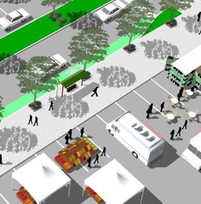
8 TOOLBOX The elements in the instant impact toolbox help create a safer and more comfortable environment for pedestrians and bicyclists. Independently, each element contributes a subtle change, but a combination of the tools will create a vibrant public space. PROGRAMMING FARMERS MARKET FOOD VENDORS POP-UP SHOPS COMMUNITY GARDEN Block off a portion of a parking lot or lane of traffic with cones or potted plants to host a farmers market. Farmers markets generate foot traffic and provide a pleasant outdoor environment for shoppers to buy local produce and other goods. Invite local food vendors to fill popup shops, bring food trucks, or set up booths. Invite local restaurants and vendors to open a pop-up shop, a temporary retail business, in a vacant storefront or to set up a booth on the sidewalk. Encourage pop-up shops by making space available, working with property owners of vacant storefronts, or expediting necessary permitting processes. Revamp a vacant lot with a community garden. Gardens don t require large swaths of open green space if you use raised planter boxes. With community support, this tool can last beyond the instant impact event. 8


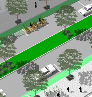
9 STREETS BIKE LANE TURF MEDIAN CROSSWALKS CURB EXTENSION Paint a bike lane on the street or delineate one with traffic cones. A comfortable bike lane is about 6 feet wide. Block off a lane of traffic or turning lane to accommodate a median made of artificial turf. Paint crosswalks at intersections and in the middle of long streets to facilitate pedestrian crossings. Add curb extensions at street corners. This extension of the sidewalk at intersections protects pedestrians by decreasing the distance to cross the street and slowing turning cars. Curb extensions can be marked with potted plants, potted trees, or traffic cones. 9


10 TOOLBOX SIDEWALKS MUSIC PARKLET SIDEWALKS BUILDING FACADES Allow musicians and bands to perform on sidewalks or other public places. Music always attracts people. Create a parklet, a tiny park often taking up one to two parking spaces or an empty lot. Parklets can be delineated by traffic cones or potted plants and can be designed to accommodate creative uses like a big chess game, cafe seating, or a garden. Widen sidewalks or walking areas by blocking off on-street parking or a lane of traffic with potted plants, potted trees, or traffic cones. Work with property owners to revitalize deteriorated and/or vacant storefronts. Quick fixes like adding a new awning, painting a storefront, or staging the windows of empty buildings can reinvigorate dilapidated or vacant buildings. 10


11 PUBLIC ART POTTED PLANTS STREET FURNITURE BIKE RACKS Invite a local artist to display his or her work, or, with the permission of a building owner, paint a mural. Line sidewalks, parklets, and turf medians with potted trees and plants. They beautify the street and add shade. Install outdoor cafe seating near restaurants and add benches along the street and in parklets. Site bike racks at destinations like pop-up shops, community gardens, and parklets. Make temporary bike racks out of wooden pallets or ask an organization to donate them. 11


12 Image: Asakura Robinson Image: Asakura Robinson SPOTLIGHT ON... HOUSTON S WASHINGTON AVENUE 12 Image: SWA


13 Image: Asakura Robinson Located in the heart of Houston, the Washington Avenue corridor has experienced significant growth in the past 10 years. In 2012, Better Houston, a nonprofit organization, led a project team that included private sector planning and design firms, public agencies, and local residents to develop a temporary instant impact project to demonstrate the pedestrian-friendly potential of Washington Avenue. The project took about three months to plan, and required approval, permits, and special event insurance from the City of Houston, a project partner. The Washington Avenue instant impact project consisted of murals; street trees; pocket parks with yard games, face painting, and children s activities; a fenced dog park on an abandoned lot; a pop-up bike repair station; a crawfish boil; a pop-up coffee shop and market; food trucks; live music; parklets; and a pop-up grocery store. To balance vehicle and foot traffic, Washington Avenue traffic lanes were reduced from five lanes to two for the duration of the seven-hour project. Most of the supplies for the event were donated materials assembled by volunteers. The Washington Avenue instant impact project only took one day to set up, cost approximately $1,000, and attracted over 1,000 pedestrians. Following the project, street trees were permanently planted along Washington Avenue and Union Street, and plans are currently being made to redesign Washington Avenue into a Complete Street. All of the storefronts that hosted popup shops are now occupied by locally-owned businesses, bars, restaurants, and coffee shops. Image: Asakura Robinson 13


14 SPOTLIGHT ON... MEMPHIS BETTER BLOCK Like many U.S. cities, Memphis, Tennessee, has suffered a decline of its urban core. Binghampton, a Memphis neighborhood characterized by high poverty rates and a declining population, was surrounded by potential assets parks, a college, a greenway, thriving neighborhoods, and a rail line. Livable Memphis (a program of the Community Development Council of Greater Memphis), Broad Avenue Arts District, Binghampton Development Corporation, Team Better Block, and a local business owner launched Build a Better Block, a two-day event to reimagine Broad Avenue. Team Better Block, a Dallasbased consulting firm, guided the community in planning and implementing the project. For one weekend in 2010, Broad Avenue used temporary bike lanes, crosswalks, food vendors, cafe seating, enhanced 14 Image: Livable Memphis pedestrian amenities, and cultural programming to create a vibrant commercial corridor. About 13,000 people participated in the event. The event was so successful it sparked $2.5 million in private investment the next year and more than $18 million in the following three years. By the fourth year, the area had 95 percent occupancy of commercial spaces, including a bike shop, bakery, micro-brewery, dance school, and other new businesses. As new investment occurred, cycling advocates raised $4.5 million for a 2-mile bike lane connecting Binghampton to nearby parks. Also, the project inspired the MEMFix program, a partnership between Livable Memphis, Innovate Memphis, the City of Memphis, and other community groups that has taken an instant impact approach to seven Memphis neighborhoods over the past five years.
 Day is to urge people to think about how urban space can be repurposed and reallocated in favor of pedestrians, instead of the car.")
15 SPOTLIGHT ON... Park(ing) Day is an annual event to transform metered on-street parking spaces into temporary public places, like parklets. The objective of Park(ing) Day is to urge people to think about how urban space can be repurposed and reallocated in favor of pedestrians, instead of the car. The first Park(ing) Day started in San Francisco in 2005 with the conversion of a single parking space into a parklet. Since then, it has grown into an international movement, inspiring thousands of Park(ing) Day projects in over 100 cities worldwide. Downtown Houston has participated in Park(ing) Day since With the installation of 14 parklets attracting about 2,000 pedestrians, the 2015 event was one of the biggest Houston Park(ing) Days to date*. The Rice Design Alliance (RDA), a Rice University educational organization dedicated to advancing architecture and urban design in the Houston region, spearheaded the event which took about three months to organize and plan. As part of the process, RDA recruited the project teams, which consisted of 14 design and planning firms, as well as community and student organizations. The group also worked with a Travis Street building owner to use the building s plaza during set-up and take-down. To obtain approval for this event, a Special Event application, Street Function permit, and traffic control were secured from the Mayor s Office of Special Events. Event insurance was also in place. HOUSTON PARK(ING) DAY The pop-up parks included miniature plazas, outdoor seating, plants, and temporary green features. Other public space installations included interactive amenities, such as a miniature putting green and a chalkboard visioning wall. Only an hour was needed to set up each parklet. Park(ing) Day inspired a permanent parking space converted to a parklet in front of a shop in the Heights area of Houston. *The 2016 event was held in mid-september. Participation totals were not available at the time this publication was printed. Image: SWA 15

16 ADDITIONAL RESOURCES H-GAC Community Enhancement Grants Program H-GAC Livable Centers Program H-GAC Pedestrian and Bicyclist Special Districts H-GAC Pedestrian Pathways Brochure Building Better Bikeways: A Planning Guide for the Houston-Galveston Region The Better Block Scenic Houston s Streetscape Resource Guide Tactical Urbanism: Volume 2, by Street Plans wwww.issuu.com/streetplanscollaborative/docs/tactical_urbanism_vol_2_final MEMFix wwww.memfix.org City of San Francisco: Parks to Pavement wwww.sfpavementtoparks.sfplanning.org New York City Department of Transportation UCLA s Reclaiming the Right-of-Way: A Toolkit for Creating and Implementing Parklets Urban Harvest 16

17 Image: Livable Memphis 17

18 IMAGE CREDITS Toolbox Image Credits, pages 8-11: Our thanks to the following organizations for generously allowing us to use their images to support this document: Asakura Robinson, Pop-Up Shops, page 8 SWA, Bike Lane, page 9 SWA, Turf Median, page 9 Team Better Block, Crosswalks, page 9 Team Better Block, Curb Extension, page 9 Clark Condon, Parklet, page 10 SWA, Sidewalks, page 10 Livable Memphis, Building Facades, page 10 SWA, Street Furniture, page 11 Asakura Robinson, Bike Racks, page 11 18

19 19


20 CE0916
FOCUS AREA 1 - Alberta Avenue Pocket Park 3 (121 Ave and 92 St)
") FOCUS AREA 1 - Alberta Avenue Pocket Park 3 (121 Ave and 92 St) New benches Plant evergreen trees Widen existing sidewalk from 1.5m to 1.8m Marked crosswalk 1.8m wide sidewalk Add pedestrian oriented lights
FOCUS AREA 1 - Alberta Avenue Pocket Park 3 (121 Ave and 92 St) New benches Plant evergreen trees Widen existing sidewalk from 1.5m to 1.8m Marked crosswalk 1.8m wide sidewalk Add pedestrian oriented lights
Perryville TOD and Greenway Plan
 Perryville TOD and Greenway Plan Greenway Glossary Pathway: A bicycle and pedestrian path separated from motorized vehicular traffic by an open space, barrier or curb. Multi-use paths may be within the
A CHANGING CITY. of Edmonton, it is essential that it reflects the long-term vision of the City.
 A CHANGING CITY By the year 2040, Edmonton will be home to more than 1 million people. To accommodate growth and support a healthy and compact city, we need a new approach to development/redevelopment
STONY PLAIN ROAD STREETSCAPE
 Jasper Place Revitalization Strategy: Vision The people involved in the Jasper Place Revitalization Strategy envision: Goal 1: Feeling safe in our community Create a community where feeling safe is common--where
WELCOME. Purpose of the Open House. Update you on the project. Present a draft recommended plan. Receive your input
 WELCOME Purpose of the Open House The Town of Smiths Falls has initiated the Beckwith Street Redevelopment Plan that includes the preparation of a streetscape functional design for the renewal of Beckwith
Complete Streets. Designing Streets for Everyone. Sarnia
 Complete Streets Designing Streets for Everyone Sarnia Complete Streets ~ Sarnia ~ 2018 Introduction Our City is made up of a network of streets that we use to go for a walk, cycle to work, drive to the
CONNECTIVITY PLAN. Adopted December 5, 2017 City of Virginia Beach
 CONNECTIVITY PLAN Adopted December 5, 2017 City of Virginia Beach CONTENTS 1.0 Background & Purpose... 2 2.0 Existing Inventory & Analysis... 3 ViBe District Existing Walking Conditions... 4 3.0 ViBe District
Streetscape: Core Shopping District
 Streetscape: Core Shopping District DRAFT DRAFT DRAFT May 00 Core Shopping District: Phase Blue Island s Core Shopping District is located along Western Avenue, between Grove and Union Streets. Streetscape
Proposed. City of Grand Junction Complete Streets Policy. Exhibit 10
 Proposed City of Grand Junction Complete Streets Policy Exhibit 10 1 City of Grand Junction Complete Streets Policy Vision: The Complete Streets Vision is to develop a safe, efficient, and reliable travel
7 Complete Streets & Roadway Aesthetics
 7 Complete Streets & Roadway Aesthetics 7.1 OVERVIEW Our streets lay the foundation for how we interface with travel needs, physical exercise, social exchanges and access to goods and services. They are
Illustrated Principles of Good Planning
 Illustrated Principles of Good Planning The Miami 21 Zoning Code incorporates time-tested planning principles into the zoning regulations of our City. These are principles that make for better neighborhoods,
York Boulevard Streetscape Master Plan
 York Boulevard Streetscape Master Plan October 24 th, 2008 The Story of York Boulevard Streetscape Master Plan Design. Chapter 126 Dealing with Engineers. 2 1 Today s Presentation Topics: 1. Show the streetscape
EXECUTIVE SUMMARY: TRANSIT-ORIENTED DEVELOPMENT IN SMITHS FALLS, ONTARIO; A COMPARISON BETWEEN TWO SITES
 EECUTIVE SUMMARY: TRANSIT-ORIENTED DEVELOPMENT IN SMITHS FALLS, ONTARIO; A COMPARISON BETWEEN TWO SITES Topic and Purpose In 2007, the Mayor of Ottawa s Task Force on Transportation suggested adding a
State Street Workshop Summary September 26, 2012 SITE A. - INTERSECTION OF STATE AND HOLLY TOTAL ATTENDEES = ~29
 State Street Workshop Summary September 26, 2012 TOTAL ATTENDEES = ~29 SITE A. - INTERSECTION OF STATE AND HOLLY What do you like best about this place? YMCA building / facade Crosswalk design Landscaping
Agenda. Overview PRINCE GEORGE S PLAZA METRO AREA PEDESTRIAN PLAN
 PRINCE GEORGE S PLAZA METRO AREA PEDESTRIAN PLAN May 28, 2008 Agenda Welcome and introductions Project overview and issue identification Planning context and strengths Design challenges and initial recommendations
PRINCE GEORGE S PLAZA METRO AREA PEDESTRIAN PLAN
 PRINCE GEORGE S PLAZA METRO AREA PEDESTRIAN PLAN May 28, 2008 Agenda Welcome and introductions Project overview and issue identification Planning context and strengths Design challenges and initial recommendations
Ann Arbor Downtown Street Plan
 1 Ann Arbor Downtown Street Plan Public Workshop #1 We know that. 2 Public right-of-way (streets, sidewalks, and alleys) make up 30% of the total District area of downtown. Streets need to provide mobility
05 Pilot Projects 68
 05 Pilot Projects 68 Gehl Studio 69 Pilot Projects in Columbus The hundreds of comments shared at the Focus Area workshops helped identify opportunities for pilot projects to test out Columbus vision and
Living Streets Policy
 Living Streets Policy Introduction Living streets balance the needs of motorists, bicyclists, pedestrians and transit riders in ways that promote safety and convenience, enhance community identity, create
Las Tunas Downtown Revitalization City Council Study Session. December 1, :00 p.m. Live Oak Park Community Center
 Las Tunas Downtown Revitalization City Council Study Session December 1, 2015 7:00 p.m. Live Oak Park Community Center AGENDA 2 Provide downtown context. Confirm project goals. Analyze three design concepts.
12/4/2016 VIA . RE: Grocery Outlet Del Paso (DR16-328)
") 12/4/2016 VIA EMAIL Ethan Meltzer, Assistant Planner City of Sacramento Community Development Department 300 Richards Blvd, 3 rd Floor Sacramento, CA 95811 RE: Grocery Outlet Del Paso (DR16-328) Dear Mr.
12/4/2016 VIA EMAIL Ethan Meltzer, Assistant Planner City of Sacramento Community Development Department 300 Richards Blvd, 3 rd Floor Sacramento, CA 95811 RE: Grocery Outlet Del Paso (DR16-328) Dear Mr.
MIXED USE AND STREETSCAPE INTEGRATION Avondale Will Basil Juliana Zannotto
 MIXED USE AND STREETSCAPE INTEGRATION Avondale Will Basil Juliana Zannotto Creating new development so that people will stop and see what Avondale has to offer The goal for my project was simple. I wanted
Strategies for Maintaining & Renewing Innovative Street Projects. Elyse Parker, Director of Policy & Innovation, City of Toronto NACTO, LA, 2018
 Strategies for Maintaining & Renewing Innovative Street Projects Elyse Parker, Director of Policy & Innovation, City of Toronto NACTO, LA, 2018 1 OUR ASSETS $12B in Assets $20B Replacement Cost $372M Capital
FOLSOM-HOWARD STREETSCAPE OVERVIEW
 FOLSOM-HOWARD STREETSCAPE OVERVIEW SoMa residents should have the same kinds of amenities that other neighborhoods have. The Folsom- Howard Streetscape Project will make SoMa more livable by making it
CITY OF BLOOMINGTON COMPLETE STREETS POLICY
 CITY OF BLOOMINGTON COMPLETE STREETS POLICY POLICY OBJECTIVE: The City of Bloomington will enhance safety, mobility, accessibility and convenience for transportation network users of all ages and abilities,
1000 FRIENDS OF FLORIDA PALM BEACH COUNTY 2070 OCTOBER 2018
 1000 FRIENDS OF FLORIDA PALM BEACH COUNTY 2070 OCTOBER 2018 HEALTHIER COMMUNITIES & BETTER ECONOMIES THROUGH COMPLETE STREETS PRESENTED BY TREASURE COAST REGIONAL PLANNING COUNCIL The Question of Safety
7/23/2017 VIA . Michael Hanebutt City of Sacramento Community Development Department 300 Richards Boulevard, 3 rd Floor Sacramento, CA 95811
 7/23/2017 VIA EMAIL Michael Hanebutt City of Sacramento Community Development Department 300 Richards Boulevard, 3 rd Floor Sacramento, CA 95811 RE: 65 th Street Apartments (DR17-220) Dear Mr. Hanebutt:
Figure 4-10: Pedestrian Improvements Types of Potential Station Area Improvements - Place-Making Improvements
 INCORPORATE FEATURE PAVIN IN CROSSWALK AND INTERSECTION FIELDS Identifies high-priority pedestrian areas and create a station identity through colorful and interesting patterns ADD CURB EXTENSIONS Extending
5 Circulation & Parking
 5 Circulation & Parking Downtown Parking & Circulation Strategy. Downtown Wayne has a somewhat disconnected system of local public streets to connect downtown with the residential neighborhoods, and primary
WALKNBIKE DRAFT PLAN NASHVILLE, TENNESSEE EXECUTIVE SUMMARY NASHVILLE, TENNESSEE
 NASHVILLE, TENNESSEE EXECUTIVE SUMMARY Executive Summary A world-class multi-modal transportation system is essential to a vibrant city and better quality of life. -Mayor Barry The WalknBike plan aims
Omaha s Complete Streets Policy
 Omaha s Complete Streets Policy (Adopted August 2015) VISION To create great places and enhance our quality of life, the City of Omaha will provide safe, accessible streets for all users. Complete Streets
Outreach Approach RENEW SF served as the primary liaison with the North Beach community; the Chinatown. Executive Summary
 Executive Summary Executive Summary The Columbus Avenue Neighborhood Transportation Study s objective is to identify changes to transportation infrastructure and policies that could enhance the livability
PUBLIC REALM MASTER PLAN
 WESTSHORE BUSINESS DISTRICT PUBLIC REALM MASTER PLAN MASTER PLAN COMMITTEE MEETING MARCH 20, 2013 WESTSHORE BUSINESS DISTRCT PUBLIC REALM MASTER PLAN MACRO-SCALE CONCEPT: A PUBLIC REALM FRAMEWORK DEFINED
SPRINGFIELD REVITALIZATION REPORT
 SPRINGFIELD REVITALIZATION REPORT August 2015 Homewood Suites Springfield Town Center Promenade 2 SPRINGFIELD OVERVIEW This report covers recent development activity in the Springfield Commercial Revitalization
Table #6 VISION CHARACTERISTICS
 Table #6 VISION White Flint is a place to live, work, play, shop, and walk with sufficient density to encourage quality redevelopment. Vibrant streets and consistent streetscapes are important. CHARACTERISTICS
MARTIN LUTHER KING JR. WAY
 OCTOBER 2011 40 Vision and Goals The Martin Luther King, Jr. Way Illustrative Master Plan that follows has been developed through a process of community involvement. It expresses a long term vision for
Active Transportation Facility Glossary
 Active Transportation Facility Glossary This document defines different active transportation facilities and suggests appropriate corridor types. Click on a facility type to jump to its definition. Bike
Berkeley Strategic Transportation Plan A-76
 Berkeley Strategic Transportation Plan A-76 Appendices 1. A Team Effort 2. Where We ve Been A-11 Berkeley Strategic Transportation Plan Alameda County Transportation Plan Alameda County will be served
Lincoln Neighborhood Corridor Plan The LiNC
 CITY OF SANTA MONICA Lincoln Neighborhood Corridor Plan The LiNC PLANNING COMMISSION September 2, 2015 COMMUNITY DESIGN + ARCHITECTURE TEAM: Community Design + Architecture Iteris Studio 111 Urban Place
5. Pedestrian System. Accomplishments Over the Past Five Years
 5. Pedestrian System Accomplishments Over the Past Five Years The Alamo Area Metropolitan Planning Organization (MPO) and its partner agencies recognize the importance of improving pedestrian mobility.
COMPLETE STREETS PLANNER S PORTFOLIO
 COMPLETE STREETS PLANNER S PORTFOLIO ISSUE 3 APRIL 2016 PLANNER S PORTFOLIO COMPLETE STREETS 1 2 6 10 14 OVERVIEW MATURE NEIGHBORHOODS GROWING SUBURBS CENTRAL PLACES ACTIVITY CORRIDORS Planner s Portfolio
Corpus Christi Metropolitan Transportation Plan Fiscal Year Introduction:
 Introduction: The Safe, Accountable, Flexible, Efficient Transportation Equity Act: A Legacy for Users (SAFETEA-LU) has continued the efforts started through the Intermodal Surface Transportation Efficiency
DOWNTOWN TENINO. Goal: Get more People in Downtown. A Pamphlet of Concepts for
 A Pamphlet of Concepts for DOWNTOWN TENINO The Tenino Planning Commission believes that the highest potential for economic development and business development in the City of Tenino (in the short-term)
Introduction. North 12 th Complete Street Project Overview
 Introduction On Wednesday, March 1, 2017, the City of Sacramento, in partnership with Sacramento Regional Transit District and the Sacramento Housing and Redevelopment Agency, hosted a community outreach
Trails that Transform: The Economic Impact of Bicycle Tourism
 Trails that Transform: The Economic Impact of Bicycle Tourism September 2016 Economic Growth Summit Alta Planning + Design Nation s leading team of bicycle, pedestrian, greenways, and trails planning and
CHAPTER 1 INTRODUCTION
 CHAPTER 1 INTRODUCTION Chapter Table of Contents THE 2017 HOUSTON BIKE PLAN 1-1 HOUSTON BIKEWAYS PROGRAM 1-2 HISTORY OF BICYCLE PLANNING IN HOUSTON 1-3 BICYCLE LEVEL OF COMFORT 1-3 EXISTING PLANS, PROGRAMS
Monterey Road Complete Streets
 Monterey Road Complete Streets Complete Street Objectives Improve livability and economic vitality Enhance pedestrian environment Accommodate bicyclists safely Reduce noise and air pollution Create attractive,
Community Task Force November 15, 2017
 Community Task Force November 15, 2017 Welcome and Introductions Project Partners Regional Transportation District (RTD) Colorado Department of Transportation (CDOT) Denver Regional Council of Governments
MEDIAN DESIGN example median A
 MEDIAN DESIGN example median A MLK Blvd Design Workshop #3 September 21, 2010 Participants voted on each idea, gave comments about specific ideas or general comments about all ideas. Comments and suggestions
Elm Street Business District: Streetscape and Signage Plan
 Winnetka Preliminary Streetscape & Signage Village Council Presentation 1 Elm Street Business District: Streetscape and Signage Plan VILLAGE OF WINNETKA DOWNTOWN MASTER PLAN VILLAGE COUNCIL PRESENTATION
Front and Myrtle Improvement Project
 Front and Myrtle Improvement Project MAKING BOISE THE MOST LIVABLE CITY IN THE COUNTRY DOWNTOWN: Our unique and vibrant urban neighborhood GUIDING PRINCIPLES: Innovation Celebration Transportation Downtown
GLEN EIRA CITY COUNCIL. MURRUMBEENA Transforming our neighbourhood together our concepts based on your ideas
 GLEN EIRA CITY COUNCIL MURRUMBEENA Transforming our neighbourhood together our concepts based on your ideas 1 WHAT HAVE WE HEARD? WHAT NOW? Stage one Tell us what you love about your shopping strip November
Road Alterations - Wellington Street East, Church Street, and Front Street Intersection
 REPORT FOR ACTION Road Alterations - Wellington Street, Church Street, and Front Street Intersection Date: November 1, 2016 To: Toronto and York Community Council From: Director, Public Realm Section,
CURBSIDE ACTIVITY DESIGN
 5 CURBSIDE ACTIVITY DESIGN This chapter provides design guidance for separated bike lanes adjacent to curbside activities including parking, loading and bus stops. Typical configurations are presented
Why invest in the 1 Street S.W. Corridor?
 Why invest in the 1 Street S.W. Corridor? This project is an investment in the Beltline Community and Calgary s economy. It is anticipated that The City s investment along this corridor will help with
2014/2015 BIKE ROUTE PLAN 83 AVENUE PROTECTED BIKE LANE
 About the Project 2014/2015 BIKE ROUTE PLAN The City of Edmonton is planning a major bike route on the south side of Edmonton. This bike route is one part of a plan to provide citizens with transportation
CHAPTER 6 Focus Areas Circle of Palms Passage Plaza Improvements
 1 before 1 after: Downtown Elements bring human scale, comfort, and a social character to the Plaza. CHAPTER 6 Focus Areas Circle of Palms Passage Plaza Improvements 179 1 Focus Area: Paseo de San Antonio
Chapter 3: Multi-Modal Circulation and Streetscapes
 CHAPTER 3: MULTI-MODAL CIRCULATION AND STREETSCAPES Chapter 3: Multi-Modal Circulation and Streetscapes Overview Streetscape improvements have already been completed for Depot Street between Main Avenue
UPTOWN REGIONAL BIKE CORRIDORS PROJECT SAN DIEGO ASSOCIATION OF GOVERNMENTS
 UPTOWN REGIONAL BIKE CORRIDORS PROJECT SAN DIEGO ASSOCIATION OF GOVERNMENTS SUMMARY REPORT: COMMUNITY UPDATE MEETING February 6, 2014 6 8:30 p.m. Roosevelt Middle School Library 3366 Park Blvd, San Diego
4 MOBILITY PLAN. Mobility Plan Objectives. Mobility Context. 1. Integrate with Local and Regional Transit Improvements
 Harbor Mixed Use CHAPTER Transit Corridor 4: Mobility Plan 4 MOBILITY PLAN Mobility Plan Objectives The Harbor Corridor Plan seeks to expand and improve the ways that people move along and through the
Making Phoenix Streets Complete. City of Phoenix Complete Streets Initiative
 Making Phoenix Streets Complete City of Phoenix Complete Streets Initiative City of Phoenix Planning Commission March 2014 Presentation Outline What are Complete Streets? Benefits of Complete Streets Complete
Bikeway action plan. Bicycle Friendly Community Workshop March 5, 2007 Rochester, MN
 Bikeway action plan Summary The was held on March 5, 2007 at the Rochester Mayo Civic Center. The workshop was hosted by Rochester-Olmsted County Planning Department in collaboration with the League of
Placemaking Workshop: Crime Prevention through Design and Placemaking (Magnolia and Railroad) October 4, 2012
 October 4, 2012") Placemaking Workshop: Crime Prevention through Design and Placemaking (Magnolia and Railroad) October 4, 2012 TOTAL ATTENDEES = ~13 SITE A. - INTERSECTION OF MAGNOLIA AND CORNWALL Open - can see. Needs
Placemaking Workshop: Crime Prevention through Design and Placemaking (Magnolia and Railroad) October 4, 2012 TOTAL ATTENDEES = ~13 SITE A. - INTERSECTION OF MAGNOLIA AND CORNWALL Open - can see. Needs
o n - m o t o r i z e d transportation is an overlooked element that can greatly enhance the overall quality of life for the community s residents.
 N o n - m o t o r i z e d transportation is an overlooked element that can greatly enhance the overall quality of life for the community s residents. 84 Transportation CHAPTER 11 INTRODUCTION Transportation
Community Improvement Plans: Creating walkable and liveable communities that support local business
 Community Improvement Plans: Creating walkable and liveable communities that support local business Kate Hall Program Manager ~ WALK Friendly Ontario Canada Walks, Green Communities Canada khall@greencommunitiescanada.org
Data Analysis February to March Identified safety needs from reported collisions and existing travel patterns.
 Welcome! Thank you for participating in today s Valencia Bikeway Improvements workshop. Data Analysis February to March Identified safety needs from reported collisions and existing travel patterns. Initial
Option W: N. Washington Street Project
 Option W: N. Washington Street Project Location: one block of North Washington Street, between West Broad Street and Park Avenue Description: upgrades to existing lighting new brick sidewalk to replace
How walk, bike, and transit friendly is your neighbourhood?
 How walk, bike, and transit friendly is your neighbourhood? What is an 8-80 City? 8-80 Cities are communities built for everyone regardless of age or ability. These communities reflect social equality
Tonight is for you. Learn everything you can. Share all your ideas.
 Strathcona Neighbourhood Renewal Draft Concept Design Tonight is for you. Learn everything you can. Share all your ideas. What is Neighbourhood Renewal? Creating a design with you for your neighbourhood.
STEERING COMMITTEE MEETING June 17, Streetscape Overview Burlington Comprehensive Master Plan
 STEERING COMMITTEE MEETING June 17, 2015 Streetscape Overview Burlington Comprehensive Master Plan 1 Introduction Slide This slide show was presented to the Burlington Steering Committee on June 17, 2015
Vision: Traditional hamlet with an attractive business/pedestrian friendly main street connected to adjacent walkable neighborhoods
 N D. Focus Area II Vision: Traditional hamlet with an attractive business/pedestrian friendly main street connected to adjacent walkable neighborhoods Transit Road Focus Area II is located in the Hamlet
Y O R K R O A D. Baltimore, Maryland. ULI Technical Assistance Panel June 18 & 19, York Road Technical Assistance Panel
 Y O R K R O A D Baltimore, Maryland ULI Technical Assistance Panel June 18 & 19, 2013 The York Road TAP Team ULI York Road TAP Chairperson Addison Palmer, STV Incorporated Technical Assistance Panelists
Why Zone In on Speed Reduction?
 Learn it. Do it. Live it! SPEED REDUCTION IN THE ZONE Why Zone In on Speed Reduction? Speeding is a serious issue that plays a major role in the risk of serious injury and pedestrian fatality in a crash.
Bicycle and Pedestrian Advisory Committee (BPAC) November 21, 2013
 November 21, 2013") Bicycle and Pedestrian Advisory Committee (BPAC) November 21, 2013 OVERALL LAND USE CONCEPT Overall Broadway Valdez District: 95.5 acres (35.1 acres right-of ways + 60.4 acres developable land) Plan Subareas:
Bicycle and Pedestrian Advisory Committee (BPAC) November 21, 2013 OVERALL LAND USE CONCEPT Overall Broadway Valdez District: 95.5 acres (35.1 acres right-of ways + 60.4 acres developable land) Plan Subareas:
WALK- AND bike-friendly TURLOCK
 WALK- AND bike-friendly TURLOCK Ideas to Encourage Walking and Biking Benefits to the COMMUNITY Get Connected People who walk and bike have many more opportunities for casual interactions with friends
2015 Florida Main Street Annual Conference. Complete Streets Equal Stronger Main Streets
 WHAT ARE COMPLETE STREETS? CASE STUDIES COMPLETING YOUR MAIN STREET 2015 Florida Main Street Annual Conference St. Petersburg, Florida August 19, 2015 WHAT ARE COMPLETE STREETS? CASE STUDIES COMPLETING
Thesis Presentation. Moorhead City Walk: A Master Plan to Reimage Moorhead, Minnesota s Urban Core. Brad Garcia Advisors: Jason Kost & Dominic Fischer
 Thesis Presentation Moorhead City Walk: A Master Plan to Reimage Moorhead, Minnesota s Urban Core Brad Garcia Advisors: Jason Kost & Dominic Fischer MOORHEAD, MN Red River Center Ave 8 TH St N FARGO, ND
Fulton Market Streetscape
 Fulton Market Streetscape Ogden Avenue to Halsted Street Public Meeting Recommended Improvements December 10th, 2014 Meeting Purpose and Goals Present Existing Conditions Community Input and Charrette
LANCASTER CITY BICYCLE NETWORK
 LANCASTER CITY BICYCLE NETWORK Downtown Merchants Meeting Wednesday, July 19, 2017 http://www.lancasteratp. DOWNTOWN WALKABILITY ANALYSIS What changes can be made, in the least amount of time, and for
Downtown Yonge BIA OBIAA Awards 2013 Submission Category: Special Events + Promotions
 Downtown Yonge BIA OBIAA Awards 2013 Submission Category: Special Events + Promotions CELEBRATE YONGE, Aug 17 Sep 16, 2012 Project Description Celebrate Yonge was a one-of-a-kind pilot event in the heart
5 CIRCULATION AND STREET DESIGN
 5 CIRCULATION AND STREET DESIGN This chapter describes circulation and streetscape improvements proposed for the Northwest Chico Specific Plan Area. It includes detailed design specifications for existing
TOWN OF PORTLAND, CONNECTICUT COMPLETE STREETS POLICY
 TOWN OF PORTLAND, CONNECTICUT COMPLETE STREETS POLICY I. VISION, GOALS & PRINCIPLES VISION To improve the streets of Portland making them safer and more accessible for all users including pedestrians,
Community Meeting February 27, 2007 Dorchester Avenue Transportation & Streetscape Improvements Action Plan February 27, 2007
 Community Meeting Tonight s Agenda 6:00 Introductions South Boston/Dot Ave Improvement Study Background 6:15 Consultant Introductions Review of Scope and Schedule Review of Proposed Corridor Wide Guidelines
CITY OF COCOA BEACH 2025 COMPREHENSIVE PLAN. Section VIII Mobility Element Goals, Objectives, and Policies
 CITY OF COCOA BEACH 2025 COMPREHENSIVE PLAN Section VIII Mobility Element Goals, Objectives, and Policies Adopted August 6, 2015 by Ordinance No. 1591 VIII MOBILITY ELEMENT Table of Contents Page Number
2014/2015 BIKE ROUTE PLAN 83 AVENUE PROTECTED BIKE LANE
 About the Project The City of Edmonton is planning a major bike route on the southside of Edmonton. The Strathcona Bike Route will connect the communities of Strathcona, Garneau and the University area,
Multimodal Transportation Plan
 Multimodal Transportation Plan The Multimodal Transportation Plan will accommodate MILLENIALS ARE DRIVING LESS. WE CANNOT BUILD OUR WAY all modes of transportation by keeping pedestrians, OUT OF CONGESTION.
Introduction. Who is WILMAPCO. Why are walkable communities important
 Walkable Community Workshops Round 1 April 2005 SPONSORED BY WILMAPCO AND CCOBH CITY OF NEW CASTLE EDGEMOOR GARDENS CIVIC ASSOCIATION WITH FUNDING BY DELAWARE DEPARTMENT OF TRANSPORTATION AND THE DELAWARE
East Burke Transportation, Safety and Capacity Improvements
 East Burke Transportation, Safety and Capacity Improvements The purpose of this project is to increase mobility and improve safety for pedestrians, cyclists, and motor vehicles along VT Route 114 in the
CONNECTING PEOPLE TO PLACES
 CONNECTING PEOPLE TO PLACES 82 EAST BENCH MASTER PLAN 07 Introduction The East Bench transportation system is a collection of slow moving, treelined residential streets and major arteries that are the
Community Open House December 13, A project of the Green Infrastructure Center, supported by Skeo Solutions
 Community Open House December 13, 2011 A project of the Green Infrastructure Center, supported by Skeo Solutions Project Background The Green Infrastructure Center, Inc. (GIC) was formed in 2006 to help
Detroiters need to be able to conveniently and reliably get to work, school, church, stores, and parks.
 Environment & MOBILITY Detroiters need to be able to conveniently and reliably get to work, school, church, stores, and parks. Several surveyed challenges related to lack of mobility ranked in the top
THE ALAMEDA CONCEPT DESIGN COMMUNITY MEETING 3. A Plan for The Beautiful Way JANUARY 28, 2010
 CONCEPT DESIGN COMMUNITY MEETING 3 JANUARY 28, 2010 AGENDA INTRODUCTION COMMUNITY INPUT ROADWAY STUDIES STREETSCAPE DESIGN STATIONS DISCUSSION SUMMARY AND DISCUSSION NEXT STEPS CLOSE INTRODUCTION SCHEDULE
Ocean Park Boulevard Streetscape Improvement Project Alternatives & Trade Offs
 City Council Study Session January 27, 2009 Ocean Park Boulevard Streetscape Improvement Project Alternatives & Trade Offs Scope of Work Purpose of Tonight s Meeting Review work to date and direct staff
Town of Ashland. Downtown Planning Initiative 2 nd Community Workshop. March 29, Presented by:
 Town of Ashland Downtown Planning Initiative 2 nd Community Workshop Presented by: March 29, 2018 Agenda Tonight Review project & goals Recap 1st workshop (September 18, 2017) Present design alternatives
MAG Town of Cave Creek Bike Study Task 6 Executive Summary and Regional Significance Report
 Page 1 MAG Town of Cave Creek Bike Study Task 6 Executive Summary and Regional Significance Report August 1, 2012 MAG Project #481 Page 2 Task 6 Executive Summary and Regional Significance Report Introduction
San Jose Transportation Policy
 San Jose Transportation Policy Protected Intersections in LOS Policies to Support Smart Growth Presented by: Manuel Pineda City of San Jose Department of Transportation Bay Area Map San Francisco Oakland
PEDALING FORWARD. A Glance at the SFMTA s Bike Program for SFMTA.COM
 PEDALING FORWARD A Glance at the SFMTA s Bike Program for 2017-2021 SFMTA.COM INTRODUCTION About This Booklet More people from all walks of life see their bicycle as a more convenient way to get where
FONTAINE AVENUE STUDY Final Report
 FONTAINE AVENUE STUDY Final Report March 28, 2005 FONTAINE AVENUE STUDY City of Charlottesville March 28, 2005 Renaissance Planning Group Kenneth Schwartz, FAIA, AICP Director of Design Leigh Wilkerson,
PEOPLE ARE PEDESTRIANS BY DESIGN JOIN THE MOVEMENT AT
 PEOPLE ARE PEDESTRIANS BY DESIGN JOIN THE MOVEMENT AT WWW.WALKDENVER.ORG Our Vision: In 2040, Denver will be the most walkable city in the United States. As a result, its residents will be the country
PEDESTRIAN ACTION PLAN
 ATTACHMENT 2 CITY OF SANTA MONICA PEDESTRIAN ACTION PLAN CITY OF SANTA MONICA PEDESTRIAN ACTION PLAN This page intentionally left blank EXECUTIVE SUMMARY CHAPTER 1 EXECUTIVE SUMMARY Setting the Stage