Community Design Charrette Meeting Summary
|
|
|
- Mabel Joleen Carpenter
- 5 years ago
- Views:
Transcription
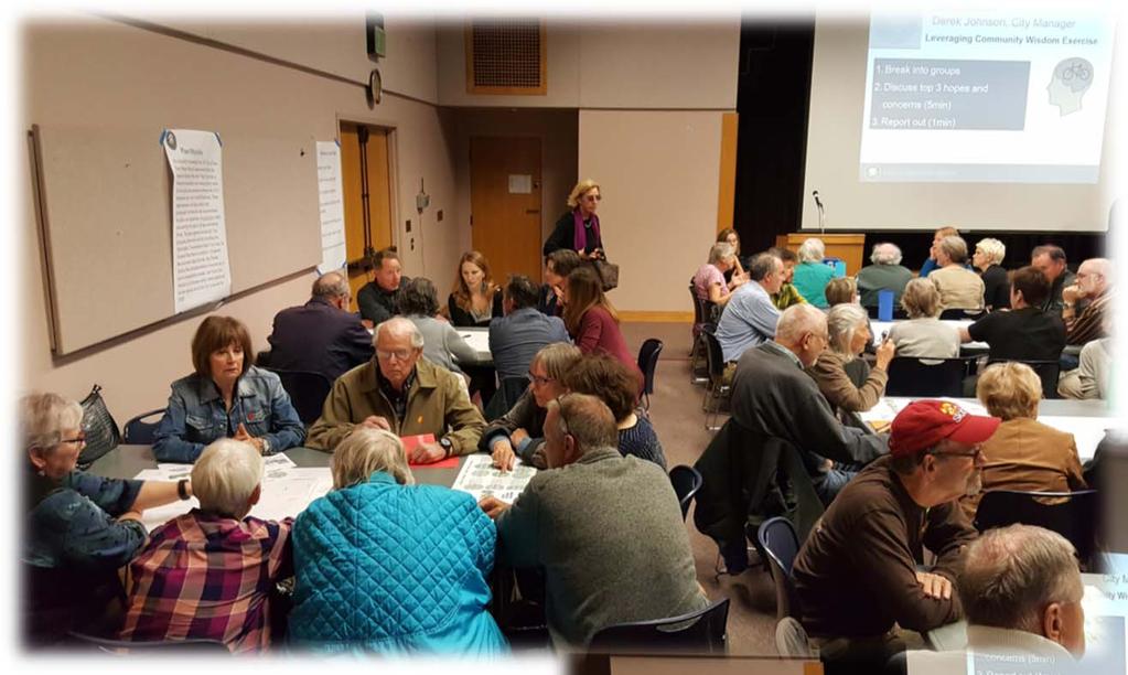
 Community Design Charrette Meeting Summary Overview: On May 10th, 2018, about 100 community residents attended a neighborhood outreach meeting to develop plans for the middle")
1 Anholm Bikeway Plan Community Design Charrette (5/10/18) & Active Transportation Committee (5/17/18) Meeting Summaries (Lincoln St. to Ramona Dr. Plan Development) Community Design Charrette Meeting Summary Overview: On May 10th, 2018, about 100 community residents attended a neighborhood outreach meeting to develop plans for the middle section of the Anholm Bikeway Plan. As adopted in April 2018, the Anholm Bikeway Plan identifies specific design recommendations for the northern section (north of Ramona Drive) and southern section (Downtown to Lincoln Street) of the proposed bikeway corridor, while calling for further development of plans for the middle section (Lincoln Street to Ramona Drive) to evaluate design options that may be acceptable to the community while also achieving the multimodal transportation goals of the Plan. The purpose of the May 10th meeting was for the community to participate in a design charrette, developing additional or different ideas to be incorporated into a refined plan that will be presented to the Active Transportation Committee (ATC), Planning Commission and ultimately, the City Council for consideration. Staff Presentation: City Manager, Derek Johnson, and City Transportation Manager, Jake Hudson, led off the community meeting with an overview of the project purpose and need, history of planning efforts conducted to date and an outline of the proposed ground rules and objectives of the design charrette. City Transportation Manager, Jake Hudson, reiterated the following specific direction in the Council-adopted Anholm Bikeway Plan with regards to the middle section of the corridor: Further evaluate Broad, Mission, Chorro and Lincoln Streets to determine if a Class III Shared Street with traffic calming and diversion on Broad, coupled with measures to mitigate impacts on Lincoln and other streets, is acceptable to the community. If a solution cannot be developed to achieve established multi-modal goals, return with a plan for protected bikeways. Staff discussed the design toolbox of traffic volume and speed management treatments available for consideration when developing their own plans as part of the design charrette. 1
2 Anholm Bikeway Plan Community Design Charrette & ATC Meeting Summaries Community Input: Before commencing with the design charrette, attendees were first asked to identify their overarching hopes and concerns for the project. Their responses are summarized as follows: Hopes Project will include traffic calming and slow down motor vehicles Design will be safe for all street users, and maintain quality of life for residents Traffic diverters will not be required Plans will optimize traffic flows Planning process will be civil Responsible use of city resources Plans will focus on a complete street approach, with roadways shared by all users Implementation approach is thoughtful, deliberate, allows for testing Concerns Potential increases in traffic on side streets Traffic diversion will create winners and losers amongst travel modes and/or residents of various streets in the neighborhood Design will be unsafe Impact to property values Removal of on-street parking Traffic calming alone will not do enough to meet city s multimodal goals Chorro Street carries an unequitable share of auto traffic Design elements will detract from the aesthetic quality of the historic neighborhood For the design charrette, attendees were organized into 11 groups, and were provided large area maps and other materials to help with designing their own desired plan for the middle section. Below is a summary of the key highlights from the design charrette submittals that the various groups presented: While the charrette ground rules explained that the design proposals should fit within the context of the Adopted Anholm Bikeway Plan, requiring a Class III shared street with traffic calming and diversion along Broad Street, only one (1) of the 11 groups presented a recommended plan that included diversion. While several tables appeared to include one or two participants who supported or were open to potential for traffic diversion, the general response from residents was opposition to physical traffic diversion within the neighborhood. 2 5/22/2018
3 Anholm Bikeway Plan Community Design Charrette & ATC Meeting Summaries Multiple groups stressed that a traffic calming package should be pursued as a first step, and to avoid considering physical diversion unless community goals cannot be met through traffic calming alone. Others presented plans that included traffic calming only, but acknowledged that this may not be enough to truly encourage shifts in mode share per the city s goals. Several groups were not able to finalize a specific design proposal, either due to lack of consensus within the group or due to challenges with developing a design that satisfied the competing interests of various stakeholders within the allotted time. There was general agreement within the groups supporting some form of traffic calming throughout the neighborhood to reduce motor vehicle speeds and reduce the attractiveness of local streets to cut-through traffic. Several groups commented that the plan needs to improve safety and accessibility for pedestrians, with higher-visibility crossings, lighting and accessible curb ramps. One group proposed the addition of a park near the US 101/Broad Street ramps. A couple of groups stressed the need for community education and enforcement to improve safety and respectful actions by all road users. A couple of attendees suggested that all bicycle travel through the neighborhood should be discouraged, instead forcing bicyclists to traverse the boundary of the neighborhood via arterial streets and regional multi-use paths. Several groups identified the desire for access restrictions and/or traffic calming on local side streets and routes parallel to Broad and Chorro (i.e. Lincoln, Almond, Meinecke) to avoid potential for increased cut-through traffic, regardless of what plan is pursued for Broad Street. A few attendees asked about potential for revisiting previously considered design concepts for the middle section, like a Lincoln Street bike route or a Broad/Chorro one-way couplet configuration with dedicated bike lanes. Many of the groups expressed a preference for traffic calming measures that provided potential for landscaping and/or aesthetic appeal for residents without significant disruption to motor vehicle flows, such as bulbouts and raised median islands/pedestrian refuges or what a few attendees called diffusers. When provided the opportunity to rank the appeal of various forms of traffic calming devices through an interactive poll, attendees ranked the following design measures from most appealing to least appealing without specific discussion of cost or constructability: 1. Median islands/pedestrian refuges 2. Bulbouts 3. Speed Humps/Cushions 4. Neighborhood Traffic Circles 5. Chicanes/Pinchpoints/Chokers 6. Diverters 3 5/22/2018
4 Anholm Bikeway Plan Community Design Charrette & ATC Meeting Summaries The staff PowerPoint presentation from the May 10 th Community Design Charrette is provided as an attachment. Active Transportation Committee Meeting Summary Overview: On May 17 th, 2018, the City Active Transportation Committee (ATC) considered plans for the middle section of the Anholm Bikeway Plan, focusing on the corridor segment between Lincoln Street and Ramona Drive. The discussion for this agenda item included a staff presentation, followed by public comment, committee deliberation and questions to staff. The primary responsibility of the ATC is to provide oversight and policy decisions on matters related to bicycle and pedestrian transportation in the city. The intent of this meeting item was to request that the ATC provide a specific recommendation to the City Council on a preferred design option for the Anholm Bikeway Plan middle section. The City Council ultimately considers input provided by staff, the community, and city advisory bodies, like the ATC, when making a final determination on plans such as the Anholm Bikeway Plan. Staff Presentation: City Transportation Planner-Engineer, Luke Schwartz, provided the staff presentation to the ATC, which included the following: Overview of project planning efforts to date and review of specific direction in the Council-adopted Anholm Bikeway Plan with regards to the middle section. Summary of the May 10 th Community Design Charrette, including prevalent comments provided by neighborhood residents, including general neighborhood opposition to physical traffic diversion. Overview of four (4) design options for the middle section that have been (a) developed per direction in the adopted Anholm Bikeway Plan, (b) developed based public input provided at the Community Design Charrette, or (c) studied in earlier phases of the Anholm Bikeway Plan development. The four (4) options are shown in the attached staff presentation and are described as follows: 4 5/22/2018
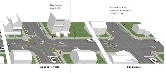
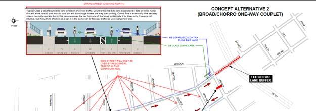
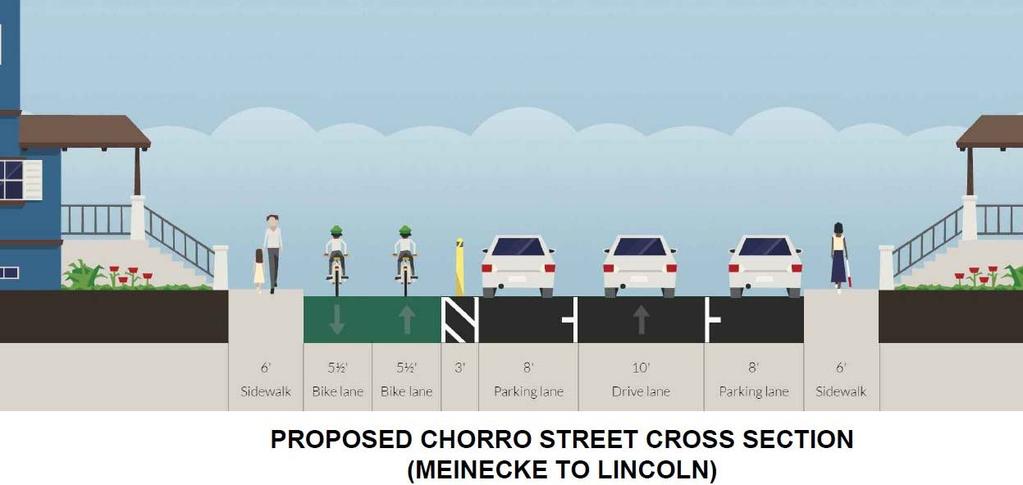
5 Anholm Bikeway Plan Community Design Charrette & ATC Meeting Summaries Options Consistent with Adopted Anholm Bikeway Plan Option #1 Shared Street with Traffic Calming and Diversion on Broad Consistent with Council direction and the adopted Anholm Bikeway Plan, this option proposes a Class III bike route ( shared street ) along Broad Street between Lincoln and Ramona. Based on community input at the May 10 th Design Charrette expressing opposition to physical traffic diversion, the final proposal for this concept developed by staff now includes a single traffic diverter on Broad between Ramona and Meinecke (multiple diverters were proposed in previous iterations of this concept). This single diverter concept shifts less auto traffic to Chorro, while still making some progress towards a low-stress bicycle environment on Broad. The single diverter is coupled with traffic calming measures along Broad, Lincoln, Chorro and other side streets to minimize speeding and cut-through concerns throughout the neighborhood. Where feasible, types of traffic calming measures are proposed based on the preferences of the community as expressed during the Community Design Charrette. Other Options for Discussion (Not Consistent with Direction in Adopted Anholm Plan) Option #2 Shared Street with Traffic Calming Only This design option establishes a Class III bike route ( shared street ) along Broad Street between Lincoln and Ramona with traffic calming, but no physical traffic diversion. Traffic calming measures are proposed along Broad, Chorro and Lincoln to reduce auto speeds and discourage potential for cutthrough traffic within the neighborhood. As with Option #1, where feasible, types of traffic calming measures are proposed based on the preferences expressed by the community. This option is not consistent with Council direction per the adopted Anholm Bikeway Plan no traffic diverters are proposed but, is sensitive to neighborhood input and general opposition to physical traffic diversion. Option #3 Revisit Protected Bike Lanes via On-Street Parking Removal This design option provides dedicated buffered and/or protected bike lanes on Chorro and Broad Streets through removal of one-side of street parking. As previously proposed by staff as the Preferred Alternative in the Draft Anholm Bikeway Plan, this option included a two-way protected bikeway along one side of Chorro Street and a protected southbound bike lane on Broad Street. Traditional one-way bike lanes without physical separation are also feasible on each side of Chorro under this design option. Per the adopted Anholm Bikeway Plan, if a solution incorporating a Class III shared street along Broad cannot be developed in a manner that is acceptable to the community while achieving established multi-modal goals, a plan for protected bike lanes may be revisited. Option #4 Revisit Protected Bike Lanes via Broad/Chorro One-Way Couplet This design option was previously considered during the Alternatives Analysis phase of the Anholm Bikeway Plan, but was ultimately discarded in favor of other alternatives. This option provides dedicated buffered and/or protected bike lanes on Chorro and Broad Streets through removal of one travel lane and conversion to one-way couplets. As previously envisioned, this option included a twoway protected bikeway along one side of Chorro Street, with Chorro configured as one-way northbound for auto traffic, and a buffered southbound bike lane on Broad Street, configured as oneway southbound for auto traffic. If further evaluation of this alternative is requested, this concept would need to be refined to provide striped bike lanes (no physical separation) in order to improve functionality for emergency service providers. This alternative is not consistent with specific direction for the middle section per the adopted Anholm Bikeway Plan. 5 5/22/2018
6 Anholm Bikeway Plan Community Design Charrette & ATC Meeting Summaries Note that these design options are illustrated in the attached PowerPoint presentation at a conceptual level and will be refined in further detail prior to presentation to the Planning Commission and City Council. Public Comment: Several members of the community provided comments on this item during the ATC meeting. The input is generally summarized as follows: Residents of the Anholm neighborhood expressed opposition to physical traffic diversion in the neighborhood; would be open to considering a neighborhoodwide traffic calming package to reduce speeds to mph if diversion is excluded. Concern that project planning needs to consider potential traffic needs and other effects of planned and approved development projects in the vicinity of the Anholm Bikeway. Letter from a group of Anholm residents to the ATC supporting consideration of protected bike lanes for the middle section of the Anholm corridor. ATC Input: Several ATC members expressed some concerns about physical traffic diversion unfairly shifting the traffic load from one street to another. Others noted that they did not believe that traffic calming alone would provide the level of low-stress shared street that will attract new bicyclists of all ages and ability levels and support the City s mode share goals. Ultimately, the ATC passed a motion to recommend a design option for the middle section that provides dedicated/protected bike lanes in place of street parking on one side of Chorro and Broad Street. This is introduced as Option #3 above and referred to previously as the Preferred Alternative in the Draft Anholm Bikeway Plan. In addition to this motion, the ATC asked staff to consider additional design refinements to this concept, including exploring potential ways to include a dedicated northbound bike lane on Broad Street between Mission and Ramona, as well as improving visibility of bicycle facility and parking lane markings along the corridor. While several of the ATC members expressed a preference for protected bike lanes, they conveyed an openness to providing traditional one-way bike lanes on each side of Chorro in lieu of the previously proposed two-way cycle track to address potential concerns regarding conflicts with driveways. Detailed ATC meeting minutes will be available in draft form in the agenda packet for the next ATC meeting (July 2018), which will be published at The staff PowerPoint presentation is included as an attachment. Next Steps: Staff will proceed with conducting technical studies and preparing refinements to conceptual designs for the middle section considering the context of the following: the adopted Anholm Bikeway Plan, input provided by the community, and the recommendations of the ATC. Current plans are to present updated concepts to the City Planning Commission on July 25, and the City Council on August 21st, The staff recommendation for the final plan is anticipated to support a preferred concept 6 5/22/2018
7 Anholm Bikeway Plan Community Design Charrette & ATC Meeting Summaries consistent with the adopted Anholm Bikeway Plan (Option #1 above), with traffic calming and a single diverter on Broad Street, with potential for installation of diversion as a temporary pilot project for testing. Staff recommendations will also present alternatives not consistent with the adopted Plan, such as the traffic calming only option supported by many Anholm residents (Option #2 above) and the ATCrecommended concept for protected bike lanes (Option #3 above). Ultimately, the City Council has the opportunity to consider input from staff, the community and City advisory bodies in selecting a final option for approval. To review previous project documents and subscribe to future updates, please visit the project website ( Attachment A: Staff PowerPoint Presentation (5/10/18 Design Charrette) Attachment B: Staff PowerPoint Presentation (5/17/18 ATC Meeting) 7 5/22/2018
8 Anholm Bikeway Meeting Design Charrette May 10, 2018 Welcome & Introduction Review of the Adopted Plan Traffic Calming Toolbox DEREK JOHNSON City Manager JAKE HUDSON Transportation Manager Design Charrette Activity Next Steps

9 Introduction Derek Johnson, City Manager Purpose of Tonight s Workshop For the community to participate in a design charrette for the "middle segment" of the corridor between Lincoln St. and Ramona Dr., developing their own ideas to be incorporated into a draft plan to be presented to the Active Transportation Committee, the Planning Commission, and the City Council for consideration.
10 Introduction Derek Johnson, City Manager Meeting Ground Rules 1. Respect each other 2. Listen with an open mind 3. Let everyone participate 4. Stay mentally and physically present 5. Contribute to meeting goals 6. Stay on topic and on time 7. Refrain from side conversations
 3.")
11 Introduction Derek Johnson, City Manager Leveraging Community Wisdom Exercise 1. Break into groups 2. Discuss top 3 hopes and concerns (5min) 3. Report out (1min)

12 Project Background
13 4 Types of Transportation Bicyclists
 Broad (S of Mission) Recommended Speeds & Volumes for Shared")
14 What Makes a Shared Street Work for All Ages & Abilities? Broad (N of Mission) Broad (S of Mission) Recommended Speeds & Volumes for Shared Street (Source: FHWA, NACTO)


15 D CAL POLY E A Traffic calming features, pavement markings & route signage on Lincoln from Chorro to Broad, and on Broad from Lincoln to Ramona A B C LINCOLN Pavement markings & route signage on Chorro between Palm and Monterey Restrict parking on north side of Ramona from Broad to planned Class I Bike Path to provide two-way protected bikeway F D B RAMONA BROAD Proposed Class I Bike/Pedestrian Path through LDS Church Property Extend buffered bike lanes on Chorro between Lincoln and Palm & add physical separation within buffer for protected bike lanes E C FERRINI F Planned enhanced bicycle and pedestrian crossing at Foothill & Ferrini Install safety lighting, streetscape & public art enhancements to improve environment at Chorro/Highway 101 undercrossing
16 Design Charrette Toolbox
17
18 Design Charrette Toolbox
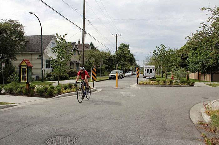
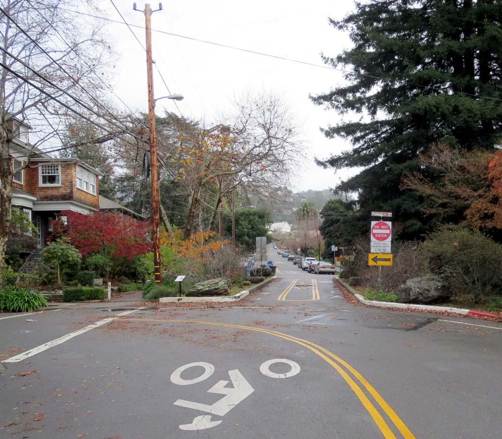
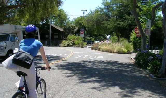
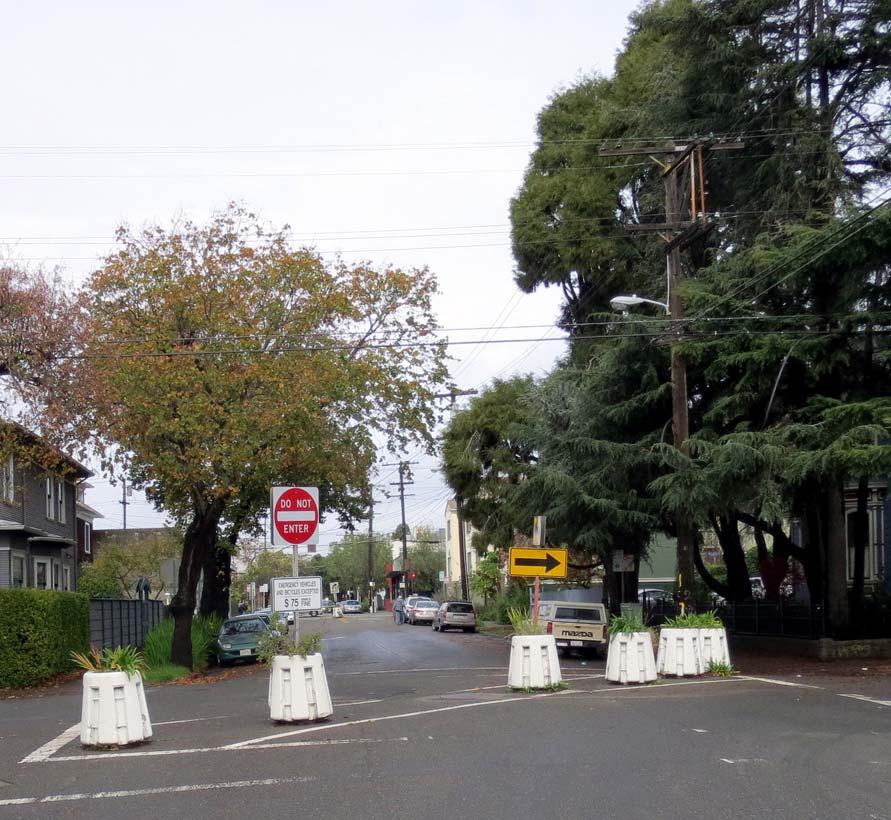
19 Neighborhood Design Examples

20 Neighborhood Design Examples
21 Neighborhood Design Examples


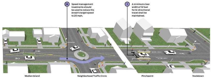
22 Design Charette Exercise Neighborhood Traffic Circles are raised islands, placed in intersections, around which traffic circulates. They are good for calming intersections where speeds, volumes, and safety are problems. Bulbouts are sidewalk extensions which shorten crossing distances for pedestrians and reduce speeds for motorists by narrowing the appearance of the roadway. Speed Humps & Raised Intersections are good for locations where very low speeds are desired and reasonable. Potential impacts to emergency response times should be considered on primary response routes. Median Islands can be used at intersections or mid-block as a traffic calming tool to make the road appear narrower. They can also be used in conjunction with bulbouts. Chicanes, Chokers and Pinch points can be used as a traffic calming tool to make the road appear narrower. In some cases, pinchpoints narrow the road to one lane to require motorists to slow and yield to opposing drivers Diverters reduce vehicle overload by redirecting traffic onto different courses. While they are very effecting at reducing vehicle volumes, special attention needs to be paid to the redirected courses to ensure that congestion isn t simply being displaced.


23 Design Charette Exercise Instructions: Take out your phone Enter in your web browser pollev.com/slocity Using the three dashed lines on the right side drag and rank the mechanisms you would like to see utilized from most preferred to least preferred

24 pollev.com/slocity
25 Anholm Bikeway Phase I: Middle Section Planning Schedule Date Tonight May 17 th Event Community Design Workshop Active Transportation Committee Review April July Prepare General Plan Update & Env. Studies July 25 th August 21 st Planning Commission Review City Council Review

26 How Can You Continue to Participate? Visit our online Open City Hall Forum for project updates and to provide feedback o OR o Search Anholm Bikeway on Staff Contacts: Adam Fukushima Active Transportation Manager (805) afukushima@slocity.gov
27 QUESTIONS? ADAM FUKUSHIMA Active Transportation Manager (805)


28 Anholm Bikeway Plan Middle Section (Lincoln to Ramona) Planning May 17, 2018 Review Project Background & Adopted Plan Feedback from Community Design Charrette LUKE SCHWARTZ Transportation Planner-Engineer Design Options for ATC Consideration Next Steps

29 Project Background Project Goal: Develop a safe, low-stress through route serving bicyclists and pedestrians of all ages and skill levels connecting the City s downtown core north to Foothill Boulevard.

30 4 Types of Transportation Bicyclists 64%
31 Project Background
32 D CAL POLY E A Traffic calming features, pavement markings & route signage on Lincoln from Chorro to Broad, and on Broad from Lincoln to Ramona A B C LINCOLN Pavement markings & route signage on Chorro between Palm and Monterey Restrict parking on north side of Ramona from Broad to planned Class I Bike Path to provide two-way protected bikeway F D B RAMONA BROAD Proposed Class I Bike/Pedestrian Path through LDS Church Property Extend buffered bike lanes on Chorro between Lincoln and Palm & add physical separation within buffer for protected bike lanes E C FERRINI F Planned enhanced bicycle and pedestrian crossing at Foothill & Ferrini Install safety lighting, streetscape & public art enhancements to improve environment at Chorro/Highway 101 undercrossing
33 What Makes a Shared Street Work for All Ages & Abilities? AVERAGE DAILY TRAFFIC VOLUME 12,000 10,000 8,000 6,000 4,000 2,000 SPEED AND VOLUME THRESHOLDS FOR SHARED BICYCLE STREET Maximum Preferred CHORRO ST (n/o Mission) BROAD ST (n/o Mission) CHORRO ST (s/o Mission) BROAD ST (s/o Mission) MOTOR VEHICLE SPEED (MPH) Recommended Speeds & Volumes for Shared Street (Source: FHWA, NACTO)

34 Community Design Charrette

35 Design Charrette Toolbox
36

37 Design Charrette Toolbox

38 Neighborhood & City Design Examples
39 Charrette Input General opposition to traffic diverters of any type/location o Concern that diversion creates winners and losers ; improves Broad St. at expense of others Concerns traffic calming won t be enough to meet mode share goals, while acknowledging challenge with competing priorities Avoid loss of on-street parking Nearly unanimous support for: Slowing traffic speeds Improving safety/accessibility of pedestrians Fostering safety & mutual respect between users A few comments about revisiting Lincoln route alignment and/or Broad/Chorro one-way couplet options
40 Design Options for Consideration Options Consistent with Adopted Anholm Bikeway Plan Option #1: Shared Street w/ Traffic Calming & Diversion Other Options for Discussion (Not Consistent with Adopted Plan) Option #2: Shared Street w/ Traffic Calming Only Option #3: Revisit Protected Bike Lanes via Parking Removal Option #4: Revisit Protected Bike Lanes via Broad/Chorro Couplet

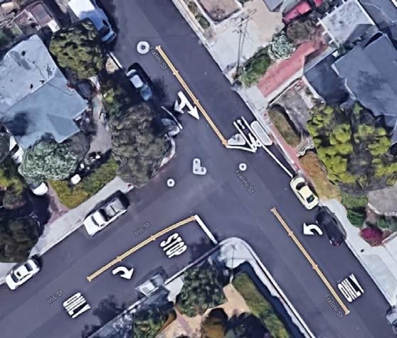
41 Option #1: Shared Street w/ Traffic Calming & Diversion


42 Option #1: Shared Street w/ Traffic Calming & Diversion


43 Option #1: Shared Street w/ Traffic Calming & Diversion
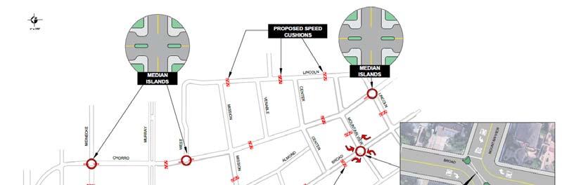
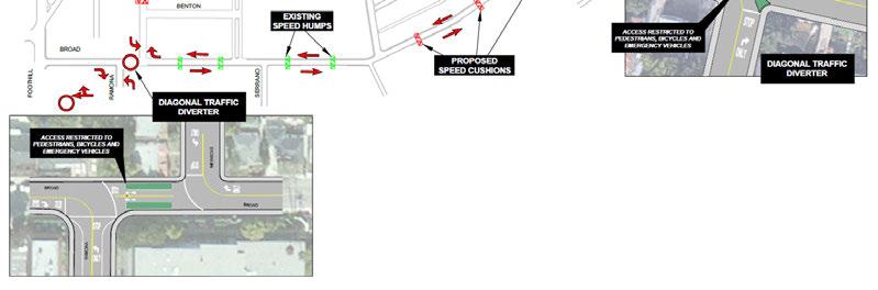
44 Option #1: Shared Street w/ Traffic Calming & Diversion Volumes w/ One Diverter Volumes w/ Multiple Diverters *Preliminary projections. Detailed traffic analysis to be refined.
45 Option #1: Shared Street w/ Traffic Calming & Diversion Pros Consistent with Council Direction/Adopted Plan Provides low-stress route that accommodates all ages & ability levels most potential to support mode share goals Single diverter shifts less traffic to Chorro (compared to previous proposals w/ multiple diverters) Can be installed for interim testing Diverter location provides strong placemaking potential for area between Ramona and Meinecke Cons Neighborhood opposition most residents opposed to diverters Increases traffic on Chorro and potentially on side streets like Meinecke & Lincoln (creates winners and losers ) Degrades conditions for bikes, peds, drivers on Chorro Loss of some on-street parking at intersection corners (prelim. estimate 20 spaces)
46 Option #2: Shared Street w/ Traffic Calming Only


47 Option #2: Shared Street w/ Traffic Calming Only
48 Option #2: Shared Street w/ Traffic Calming Only Pros Cons Reducing auto speeds generally supported by community No significant changes to auto circulation/access Speed reductions will provide some benefit to walking, bicycling and neighborhood quality Intuitive/familiar design Not consistent with Council Direction/Adopted Plan Less potential to encourage increased bike mode share through traffic calming alone Loss of some on-street parking at intersection corners (prelim. estimate 20 spaces; similar to diverter option) Type of features and aesthetic quality most desired by neighborhood requires highest cost to construct


")
49 Option #3: Protected/Buffered Bike Lanes via Parking Removal (Preferred Alternative in Draft Anholm Bikeway Plan) West Side of Street OR

 Addition of")

50 Option #3: Protected/Buffered Bike Lanes via Parking Removal (Preferred Alternative in Draft Anholm Bikeway Plan) Addition of dashed centerline on Broad will allow drivers to pass bicyclists safely
51 Option #3: Protected/Buffered Bike Lanes via Parking Removal (Preferred Alternative in Draft Anholm Bikeway Plan) Pros Protected bike lanes show strongest potential to attract new riders & increase mode share No changes to auto circulation/access Route follows existing bicycling desire lines Concept would also include traffic calming, reducing auto speeds through neighborhood Cons On-street parking loss Learning curve with new type of bike facility Concerns with driveway conflicts & confusion with two-way cycle track Remedied w/ design revision to use standard one-way bike lanes
52 Option #4: Protected/Buffered Bike Lanes via Broad/Chorro One-Way Couplet (from 2017 Alternatives Analysis)
53 Option #4: Protected/Buffered Bike Lanes via Broad/Chorro One-Way Couplet (from 2017 Alternatives Analysis) Concerns w/ Broad/Chorro couplet design as presented in 2017 Alternatives Analysis: Least desirable alternative for Emergency Service Providers Concern with learning curve & driveway conflicts associated with two-way cycle track Speeding issues w/ one-way streets Potential for increased auto traffic along side-streets between Broad & Chorro Major circulation change; costly/difficult to test
54 Option #4: Protected/Buffered Bike Lanes via Broad/Chorro One-Way Couplet (Modified Design)
")
55 Option #4: Protected/Buffered Bike Lanes via Broad/Chorro One-Way Couplet (Modified Design) CHORRO STREET
")
56 Option #4: Protected/Buffered Bike Lanes via Broad/Chorro One-Way Couplet (Modified Design) BROAD STREET
57 Option #4: Protected/Buffered Bike Lanes via Broad/Chorro One-Way Couplet (Modified Design) Pros Provides dedicated bike lanes in both directions on Chorro and in one direction on Broad Balances traffic load between Broad & Chorro Fewer conflict points at pedestrian/bicycle crossings Less on-street parking loss compared to other protected bike lane option Cons Not consistent with Council Direction/Adopted Plan Significant change; difficult/costly to test Less convenient auto access for residents on Broad/Chorro Cannot achieve protected bike lanes while meeting desires of emergency service providers Dedicated bike lane possible in one direction only on majority of Broad Contra-flow bike lanes less intuitive, concerns with driveways/parking lane One-way bike circulation not consistent with desire lanes, may lead to wrong-way travel Still requires traffic calming to reduce potential for speeding common with oneway streets Some parking loss ( spaces)
58 Anholm Bikeway Phase I: Middle Section Planning Schedule Date May 10 th May 17 th Event Community Design Workshop Active Transportation Committee Review April July July 25 th August 21 st Prepare Traffic & Environmental Studies & General Plan Amendments (if needed) Planning Commission Review City Council Review Design & Construction of Anholm Bikeway Phase II (includes middle segment )
59 Staff Recommendation Consider conceptual design options for the middle section of the Anholm Bikeway, and community input provided at the May 10 th Design Charrette, and identify a preferred alternative to be recommended to the Planning Commission and City Council. Alternatives: 1. Select specific features from various options and recommend a hybrid or phased option to the City Council. 2. Recommend that the Council adopt no plan and make no changes to streets in this neighborhood at this time.
60 QUESTIONS? LUKE SCHWARTZ Transportation Planner-Engineer (805) JENNIFER RICE Transportation Planner-Engineer (805) ADAM FUKUSHIMA Active Transportation Manager (805)
Anholm Bikeway Plan Planning Commission Meeting Summary (8/14/18)
") Anholm Bikeway Plan Planning Commission Meeting Summary (8/14/18) Overview: On August 14, 2018, the Planning Commission considered plans for the middle section of the Anholm Bikeway Plan, focusing on the
Anholm Bikeway Plan Planning Commission Meeting Summary (8/14/18) Overview: On August 14, 2018, the Planning Commission considered plans for the middle section of the Anholm Bikeway Plan, focusing on the
Broad Street Bicycle Boulevard City Council Study Session Summary
 Broad Street Bicycle Boulevard City Council Study Session Summary Overview: On August 15 th, 2017, a City Council Study Session was held to invite community input and request City Council guidance on a
CITY OF SLO SEEKS INPUT ON PREFERRED ALTERNATIVE FOR BROAD STREET BICYCLE BOULEVARD PROJECT
 City of San Luis Obispo, News Release DATE: August 1, 2017 RELEASE: Immediate CONTACT: Luke Schwartz (805) 781-7190 Transportation Planner-Engineer, Public Works CITY OF SLO SEEKS INPUT ON PREFERRED ALTERNATIVE
Broad Street Bicycle Boulevard Design Guidelines
 Broad Street Bicycle Boulevard Design Guidelines Building from the strategies introduced in the 2013 Bicycle Transportation Plan and community input received thus far, City Transportation Staff have identified
Appendix C. TRAFFIC CALMING PROGRAM TOOLBOX
 Appendix C. TRAFFIC CALMING PROGRAM TOOLBOX PHASE I...2 Do Not Enter Sign...3 One-Way Sign...4 Turn Prohibition...5 Pavement Markings...6 Speed Monitoring Trailer...7 Neighborhood Speed Watch...8 Police
Lee s Summit Road Improvement Study Public Open House June 7, 2007 Summary of Comment Card Responses
 Lee s Summit Road Improvement Study Public Open House June 7, 2007 Summary of Comment Card Responses Introduction At the Lee s Summit Road Improvement Study Public Open House held Thursday, June 7, 2007
The Wiggle Route in Context
 The Wiggle Route in Context In a city of hills, the Wiggle is an important route because it winds its way along the flattest streets from Market to the Panhandle, bringing residents to local parks and
2014/2015 BIKE ROUTE PLAN 83 AVENUE PROTECTED BIKE LANE
 About the Project 2014/2015 BIKE ROUTE PLAN The City of Edmonton is planning a major bike route on the south side of Edmonton. This bike route is one part of a plan to provide citizens with transportation
TRAFFIC CALMING GUIDE FOR TORONTO CITY OF TORONTO TRANSPORTATION SERVICES DIVISION
 TRAFFIC CALMING GUIDE FOR TORONTO CITY OF TORONTO TRANSPORTATION SERVICES DIVISION CITY OF TORONTO TRANSPORTATION SERVICES DIVISION 2016 TRAFFIC CALMING GUIDE FOR TORONTO TABLE OF CONTENTS Introduction
Bicycle Facilities Planning
 Bicycle Facilities Planning Overview Types of Cyclists Purpose for Riding Types of Facilities Bike Lanes Bicycle Boulevards Cycle Tracks Intersections Signals Signing and Marking Discussion Types of Bicyclists
Los Altos Hills Town Council - June 18, 2015 Palo Alto City Council June 22, AGENDA ITEM #2.B Presentation
 Los Altos Hills Town Council - June 18, 2015 Palo Alto City Council June 22, 2015 AGENDA ITEM #2.B Presentation Previous Presentations Los Altos Hills Town Council in May 2014 and February 2015 Palo Alto
Tonight is for you. Learn everything you can. Share all your ideas.
 Strathcona Neighbourhood Renewal Draft Concept Design Tonight is for you. Learn everything you can. Share all your ideas. What is Neighbourhood Renewal? Creating a design with you for your neighbourhood.
HARRISON STREET/OAKLAND AVENUE COMMUNITY TRANSPORTATION PLAN
 HARRISON STREET/OAKLAND AVENUE Community Workshop #4: Draft Plan Review December 3, 2009 D E S I G N, C O M M U N I T Y & E N V I R O N M E N T INTRODUCTIONS Key Project Staff: Alisa Shen, Project Manager,
City of Novi Non-Motorized Master Plan 2011 Executive Summary
 City of Novi Non-Motorized Master Plan 2011 Executive Summary Prepared by: February 28, 2011 Why Plan? Encouraging healthy, active lifestyles through pathway and sidewalk connectivity has been a focus
2014/2015 BIKE ROUTE PLAN 83 AVENUE PROTECTED BIKE LANE
 About the Project The City of Edmonton is planning a major bike route on the southside of Edmonton. The Strathcona Bike Route will connect the communities of Strathcona, Garneau and the University area,
Exhibit 1 PLANNING COMMISSION AGENDA ITEM
 Exhibit 1 PLANNING COMMISSION AGENDA ITEM Project Name: Grand Junction Circulation Plan Grand Junction Complete Streets Policy Applicant: City of Grand Junction Representative: David Thornton Address:
PRINCE GEORGE S PLAZA METRO AREA PEDESTRIAN PLAN
 PRINCE GEORGE S PLAZA METRO AREA PEDESTRIAN PLAN May 28, 2008 Agenda Welcome and introductions Project overview and issue identification Planning context and strengths Design challenges and initial recommendations
BETHEL ROAD AND SEDGWICK ROAD CORRIDOR STUDY
 DRAFT PLAN City Council Meeting August 14, 2017 STUDY AREA Sedgwick Corridor State Route 160, principal arterial with Class 3 access management designation, commuter and freight route, connection to SR
Cycle Track Design Best Practices Cycle Track Sections
 Design Best Practices Sections It is along street segments where the separation and protection methods of cycle tracks offer more comfort than conventional bicycle lanes, and are more attractive to a wide
Pedestrian & Bicycle Safety Innovations & Applications
 Pedestrian & Bicycle Safety Innovations & Applications County Engineers Association of Maryland Spring, 2017 Conference May 25, 2017 George Branyan Pedestrian Program Coordinator District Department of
Dr. M.L. King, Jr. Street North Complete Streets Resurfacing Opportunities HOUSING, LAND USE, AND TRANSPORTATION COMMITTEE MARCH 22, 2018
 Dr. M.L. King, Jr. Street North Complete Streets Resurfacing Opportunities HOUSING, LAND USE, AND TRANSPORTATION COMMITTEE MARCH 22, 2018 What s Happening The City plans to mill and resurface Dr. M.L.
Executive Summary Route 30 Corridor Master Plan
 Route Corridor Master Plan Project Overview The Route Corridor Master Plan is a coordinated multimodal transportation and land use plan for the entire stretch of Route through East Whiteland Township,
City of Wilsonville 5 th Street to Kinsman Road Extension Project
 City of Wilsonville 5 th Street to Kinsman Road Walking Tour & Neighborhood Workshop Summary Report Public Outreach Overview On July 18 th, 2017, the City of Wilsonville hosted a neighborhood walking tour
Agenda. Overview PRINCE GEORGE S PLAZA METRO AREA PEDESTRIAN PLAN
 PRINCE GEORGE S PLAZA METRO AREA PEDESTRIAN PLAN May 28, 2008 Agenda Welcome and introductions Project overview and issue identification Planning context and strengths Design challenges and initial recommendations
REGIONAL BICYCLE AND PEDESTRIAN DESIGN GUIDELINES
 REGIONAL BICYCLE AND PEDESTRIAN DESIGN GUIDELINES November 16, 2011 Deb Humphreys North Central Texas Council of Governments Bicycle and Pedestrian Advisory Committee Snapshot of the Guide 1. Introduction
Memorandum. Sunday, July 13, Saturday, July 19, 2014
 Memorandum To: David Lowin, Brooklyn Bridge Park Corporation From: Daniel Schack, AICP, PTP Date: Re: Brooklyn Bridge Park Pier 5/6 Loop Road Traffic Study Project No: 14-01-2407 At the request of Brooklyn
Simulation Analysis of Intersection Treatments for Cycle Tracks
 Abstract Simulation Analysis of Intersection Treatments for Cycle Tracks The increased use of cycle tracks also known as protected bike lanes has led to investigations of how to accommodate them at intersections.
City of Elizabeth City Neighborhood Traffic Calming Policy and Guidelines
 City of Elizabeth City Neighborhood Traffic Calming Policy and Guidelines I. Purpose: The City of Elizabeth City is committed to ensure the overall safety and livability of residential neighborhoods. One
Town of Mooresville, North Carolina Neighborhood Traffic Calming and Control Device Policy
 Town of Mooresville, North Carolina Neighborhood Traffic Calming and Control Device Policy Adopted January 6, 2014 Town of Mooresville Development Services Department TOWN OF MOORESVILLE NEIGHBORHOOD TRAFFIC
Neighborhood Traffic Calming Guidelines
 Neighborhood Traffic Calming Guidelines ADOPTED BY THE CITY COUNCIL OF ARROYO GRANDE BY RESOLUTION NO. 2016-4718 ON APRIL 12, 2016 COMMUNITY DEVELOPMENT DEPARTMENT ENGINEERING DIVISION 300 East Branch
Governance and Priorities Committee Report For the July 2, 2015 Meeting
 CITY OF VICTORIA For the July 2, 2015 Meeting To: Governance and Priorities Committee Date: From: Subject: Brad Dellebuur, A/Assistant Director, Transportation and Parking Services Executive Summary The
Chapter 2: Standards for Access, Non-Motorized, and Transit
 Standards for Access, Non-Motorized, and Transit Chapter 2: Standards for Access, Non-Motorized, and Transit The Washtenaw County Access Management Plan was developed based on the analysis of existing
TRAFFIC CALMING TOOLBOX. For the residents of the City of Decatur, Georgia
 TRAFFIC CALMING TOOLBOX For the residents of the City of Decatur, Georgia 2 City of Decatur Traffic Calming Toolbox Public Works Department 2635 Talley Street Decatur, GA 30030 404.377.5571 3 Welcome to
Chapter 4 TOOLBOX AND SAMPLE BIKE BOULEVARD LAYOUT
 Chapter 4 TOOLBOX AND SAMPLE BIKE BOULEVARD LAYOUT OVERVIEW This chapter describes a cohesive set of strategies to create a bicycle boulevard, namely to make streets safer and more efficient for bicycle
Neighborhood Traffic Calming Program
 Neighborhood Traffic Calming Program Adopted by Town Council on: October 23 rd, 2007 Resolution #: 2007-124 PROPOSED REVISIONS February 8, 2012 pg. 1 TABLE OF CONTENTS 1.0 INTRODUCTION...3 2.0 PROGRAM
UPTOWN REGIONAL BIKE CORRIDORS PROJECT SAN DIEGO ASSOCIATION OF GOVERNMENTS
 UPTOWN REGIONAL BIKE CORRIDORS PROJECT SAN DIEGO ASSOCIATION OF GOVERNMENTS SUMMARY REPORT: COMMUNITY UPDATE MEETING February 6, 2014 6 8:30 p.m. Roosevelt Middle School Library 3366 Park Blvd, San Diego
EXECUTIVE SUMMARY. Vision
 Vision Walking and bicycling in Salt Lake City will be safe, convenient, comfortable, and viable transportation options that connect people to places, foster recreational and economic development opportunities,
PROJECT OVERVIEW. 20th Avenue Project Limits (Lincoln Way to Wawona St)
") PROJECT OVERVIEW In 2014, San Francisco adopted Vision Zero as City policy, with a commitment to eliminate all traffic deaths in the City by 2024. nue Project Limits (Lincoln Way to St) Collision data
PROJECT OVERVIEW In 2014, San Francisco adopted Vision Zero as City policy, with a commitment to eliminate all traffic deaths in the City by 2024. nue Project Limits (Lincoln Way to St) Collision data
Balancing Operation & Safety for Motorized and Non-Motorized Traffic
 Balancing Operation & Safety for Motorized and Non-Motorized Traffic Brian Willham, PE, PTOE Iowa Director - MOVITE June 30, 2014 Learning Objectives: When & Why should we measure the performance of complete
MEMORANDUM TERESA MCCLISH, COMMUNITY DEVELOPMENT DIRECTOR SUBJECT: CONSIDERATION OF DRAFT NEIGHBORHOOD TRAFFIC CALMING GUIDELINES
 MEMORANDUM TO: FROM: BY: TRAFFIC COMMISSION TERESA MCCLISH, COMMUNITY DEVELOPMENT DIRECTOR MATT HORN, CITY ENGINEER SUBJECT: CONSIDERATION OF DRAFT NEIGHBORHOOD TRAFFIC CALMING GUIDELINES DATE: MARCH 28,
Glebe Neighbourhood Cycling Plan
 Glebe Neighbourhood Cycling Plan Summary of Public Comments received after June 5 th Public Information Session Comment STUDY NETWORK CS9, CS8, E, E0 CS4, E CS4 CS8 E Suggestions for alternate cycling
Monterey Road Complete Streets
 Monterey Road Complete Streets Complete Street Objectives Improve livability and economic vitality Enhance pedestrian environment Accommodate bicyclists safely Reduce noise and air pollution Create attractive,
Recommendations. Central Salem Mobility Study
 Central Salem Mobility Study The Central Salem Mobility Study evaluated a range of multimodal transportation issues affecting downtown Salem, including circulation, access, and safety for people traveling
Implementing Complete Streets in Ottawa. Project Delivery Process and Tools Complete Streets Forum 2015 October 1, 2015
 Implementing Complete Streets in Ottawa October 1, 2015 The Essentials Complete Streets Implementation Framework will become part of the routine delivery of City transportation projects Approach uses every
II. EXISTING NEIGHBORHOODS
 TABLE OF CONTENTS Page I. INTRODUCTION Purpose... 1-1 How To Use This Document... 1-1 Goals and Objectives....... 1-2 History of the Policy.... 1-3 For Further Assistance... 1-6 Policy Revisions......
CONTENTS EXECUTIVE SUMMARY 1
 CONTENTS CHAPTER PAGE EXECUTIVE SUMMARY 1 1 ISSUES AND PURPOSE OF THE ANALYSIS 2 1.1 Background 2 1.2 Analysis Area 2 1.3 Issues and Observations 3 1.4 Project and Public Meetings 3 2 LIST OF PREFERRED
Sandwich Pedestrian/Bicycle Planning
 Sandwich Pedestrian/Bicycle Planning Improved Pedestrian and Bicycle Connections with the Cape Cod Canal Multi-use Path February 2014 Table of Contents Introduction... 1 Background... 1 Study Goals...
AGENDA ITEM SUMMARY SPECIAL AGENDA ITEM NO. _1A_
 AGENDA ITEM SUMMARY AGENCY: City Council MEETING DATE: June 25, 2012 DEPARTMENT: Community Dev PREPARED BY: T Spade DEPT. DIR. APPROVAL: MJ CITY MGR. APPROVAL: LR PRESENTED BY: T Spade TITLE: RECEIVE REPORT
Pennsylvania Avenue (CR 484) Design Alternatives Study
 Design Alternatives Study") MEMORANDUM Pennsylvania Avenue (CR 484) Design Alternatives Study Prepared for: APRIL 2016 Prepared By TABLE OF CONTENTS Project Background... 2 Previous Concept... 2 Existing Conditions... 4 New Alternatives...
MEMORANDUM Pennsylvania Avenue (CR 484) Design Alternatives Study Prepared for: APRIL 2016 Prepared By TABLE OF CONTENTS Project Background... 2 Previous Concept... 2 Existing Conditions... 4 New Alternatives...
Corpus Christi Metropolitan Transportation Plan Fiscal Year Introduction:
 Introduction: The Safe, Accountable, Flexible, Efficient Transportation Equity Act: A Legacy for Users (SAFETEA-LU) has continued the efforts started through the Intermodal Surface Transportation Efficiency
» Draft Recommendations» Discussion» Next Steps. Plan for Walking and Biking
 SAC Meeting Plan #3 for September Walking and 12, Biking 2018 » Draft Recommendations» Discussion» Next Steps Plan for Walking and Biking » Stakeholder and Public Outreach» Background data collection and
Safe Routes to School (SRTS) Improvements for Bishop s Peak & Pacheco Elementary Meeting #2 Summary
 Improvements for Bishop s Peak & Pacheco Elementary Meeting #2 Summary") Safe Routes to School (SRTS) Improvements for Bishop s Peak & Pacheco Elementary Meeting #2 Summary Overview. On March 8 th, 2017, community residents attended the second in a series of neighborhood meetings
Safe Routes to School (SRTS) Improvements for Bishop s Peak & Pacheco Elementary Meeting #2 Summary Overview. On March 8 th, 2017, community residents attended the second in a series of neighborhood meetings
Commerce Street Complete Street Project from Good Latimer Expressway to Exposition Avenue
 Commerce Street Complete Street Project from Good Latimer Expressway to Exposition Avenue T A N Y A B R O O K S A S S I S T A N T D I R E C T O R M O B I L I T Y P L A N N I N G M O B I L I T Y A N D S
Bicycle Network. Vision Zero San Francisco The City and County of San
 PROJECT BACKGROUND Project Needs 1. 17th between Church and Sanchez is identified as a location where there is a disproportionate number of crashes involving people riding bikes. 2. There is currently
FEDERAL HIGHWAY ADMINISTRATION APPLICATION
 FEDERAL HIGHWAY ADMINISTRATION APPLICATION REQUEST FOR PERMISSION TO EXPERIMENT WITH A BICYCLE BOX INTERSECTION TREATMENT Submitted by: City of Columbus Department of Public Service Date: June 26, 2009
SPEED MANAGEMENT FOR VISION ZERO
 SPEED MANAGEMENT FOR VISION ZERO LUANN HAMILTON, DEPUTY COMMISSIONER FOR PROJECT DEVELOPMENT CHICAGO DEPARTMENT OF TRANSPORTATION NACTO DESIGNING CITIES 2017 Vision Zero Action Plan Speed management and
Community Task Force March 14, 2018
 Community Task Force March 14, 2018 Welcome and Introductions Project Partners Regional Transportation District (RTD) City of Aurora Colorado Department of Transportation (CDOT) Denver Regional Council
City of Davis East Covell Corridor Plan
 Community Open House #2 January 22, 2014 6:00 8:00 p.m. Veterans Memorial Center, Club Room City of Davis Introduction The (ECCP) is a taking a comprehensive look at the existing transportation systems
Summary: Mercer County Princeton Avenue & Spruce Street Study January 2009
 Summary: Several recent studies have assessed potential development and redevelopment opportunities in the Mercer Crossing area of Trenton, Ewing, and Lawrence. This Princeton Avenue and Spruce Street
Albany Shaker Road Corridor Study Public Meeting # 2
 Albany Shaker Road Corridor Study Public Meeting # 2 Scope / Meeting Purpose This project is a CDTC Linkage Study. The Linkage Program is designed to implement the adopted planning and investment principles
Standing Committee on Policy and Strategic Priorities. Potential Granville Bridge Connector Public Engagement
 ADMINISTRATIVE REPORT Report Date: January 22, 2019 Contact: Paul Storer Contact No.: 604.873.7693 RTS No.: 12877 VanRIMS No.: 08-2000-20 Meeting Date: January 30, 2019 TO: FROM: SUBJECT: Standing Committee
Draft Traffic Calming Policy Paper
 Draft Traffic Calming Policy Paper What is Traffic Calming The term traffic calming is defined differently throughout the United States. The Institute of Transportation Engineers, an international educational
Town of Southwest Ranches Neighborhood Traffic Calming Program
 Town of Southwest Ranches The provides residents an opportunity to present a concern for traffic safety with respect to observed volume and speeds on neighborhood streets and a formal method to study and
Broadway Complete Streets Project
 Broadway Complete Streets Project Megan Johnson, P.E. Associate Civil Engineer James Pangburn, P.E. Consultant Project Manager After the construction of the highway system, Broadway was cut off
Chapter 3: Multi-Modal Circulation and Streetscapes
 CHAPTER 3: MULTI-MODAL CIRCULATION AND STREETSCAPES Chapter 3: Multi-Modal Circulation and Streetscapes Overview Streetscape improvements have already been completed for Depot Street between Main Avenue
TRAFFIC ACTION PLAN. Laurie Meadows Neighborhood CITY OF SAN MATEO
 TRAFFIC ACTION PLAN Laurie Meadows Neighborhood CITY OF SAN MATEO Draft January 2017 Table of Contents Introduction... 2 The Traffic Forum Process... 5 Neighborhood Traffic Issues... 7 Neighborhood Recommendations
City of Vallejo Traffic Calming Toolbox
 City of Vallejo Traffic Calming Toolbox June 1, 2013 Final Table of Contents Introduction... 1 Non-Physical Devices... 3 High-Visibility Crosswalk... 3 In Pavement Lighted Crosswalk... 4 Rapid Flashing
Active Transportation Facility Glossary
 Active Transportation Facility Glossary This document defines different active transportation facilities and suggests appropriate corridor types. Click on a facility type to jump to its definition. Bike
Watertown Complete Streets Prioritization Plan. Public Meeting #1 December 14, 2017
 Watertown Complete Streets Prioritization Plan Public Meeting #1 December 14, 2017 Goals for Public Meeting Overview of MassDOT Complete Streets Funding Program Educate the community on Complete Streets
Omaha s Complete Streets Policy
 Omaha s Complete Streets Policy (Adopted August 2015) VISION To create great places and enhance our quality of life, the City of Omaha will provide safe, accessible streets for all users. Complete Streets
Capital Metro Downtown Multimodal Station
 Capital Metro Downtown Multimodal Station Open House December 11, 2015 Project Goals & Objectives 1 2 3 4 Address near- and long- term MetroRail operational needs Address existing safety issues and modal
Display Boards Including Five Refined Design Concepts
 APPENDIX D Workshop Session 3 Sign-in sheets Agenda Booklet Display Boards Including Five Refined Design Concepts PowerPoint Presentation Questions Recorded Discussion of Preference Exercise AGENDA
Environmental Assessment Findings & Recommendations. Public Hearing November 13, 2014
 Environmental Assessment Findings & Recommendations Public Hearing November 13, 2014 Welcome! Welcome and Introductions Project and Environmental Assessment Overview Public Comments Adjourn Purpose of
Vision: Traditional hamlet with an attractive business/pedestrian friendly main street connected to adjacent walkable neighborhoods
 N D. Focus Area II Vision: Traditional hamlet with an attractive business/pedestrian friendly main street connected to adjacent walkable neighborhoods Transit Road Focus Area II is located in the Hamlet
How to Develop a Pedestrian Safety Action Plan
 How to Develop a Pedestrian Safety Action Plan Course Introduction Presented by: Peter Eun FHWA RC Safety Engineer Ryan Snyder President, Ryan Snyder Associates, LLC Paul Zykofsky Director, Land Use and
Bobbie Walthall. Hi Bobby, please include these comments in tonight s CC packet. Thanks for your consideration, Phil Collison Lawrence Resident
 Bobbie Walthall From: Sent: To: Subject: Phil Collison Tuesday, October 16, 2018 9:44 AM Bobbie Walthall Comments for Agenda item 3 Bike Boulevard Hi Bobby, please include these comments
Off-road Trails. Guidance
 Off-road Trails Off-road trails are shared use paths located on an independent alignment that provide two-way travel for people walking, bicycling, and other non-motorized users. Trails specifically along
Appendix 3 Roadway and Bike/Ped Design Standards
 Appendix 3 Roadway and Bike/Ped Design Standards OTO Transportation Plan 2040 4/20/2017 Page A3-1 Adopted Standards The adopted OTO Design Standards and Major Thoroughfare Plan are contained herein.
Central Avenue Bikeway Traffic and Safety Impact Assessment
 FEBRUARY 2018 Lead Agency: San Diego Association of Governments (SANDAG) 401 B Street, Suite 800 San Diego, CA 92101 Contact: Chris Carterette, AICP, Project Manager 619.699.7319 chris.carterette@sandag.org
Ocean Park Boulevard Green Street Project Alternatives & Trade Offs
 Planning Commission March 4, 2009 Ocean Park Boulevard Green Street Project Alternatives & Trade Offs Purpose of Tonight s Meeting Review concept plans and options Provide input on alternatives and trade-offs
Revised Neighborhood Traffic Calming Program
 Revised Neighborhood Traffic Calming Program Adopted by Town Council on: May 15, 2012 Resolution #: 2012-31 TABLE OF CONTENTS 1.0 INTRODUCTION...3 2.0 PROGRAM MISSION STATEMENT AND OBJECTIVES...3 3.0 POLICIES...3
Telegraph Avenue Complete Streets DRAFT Recommendations. Oakland Public Works Department September 11 and 13, 2014 Open Houses
 Telegraph Avenue Complete Streets DRAFT Recommendations Oakland Public Works Department September 11 and 13, 2014 Open Houses Presentation Overview What are complete streets? What problem are we trying
Caltrans Sloat Boulevard Pedestrian Safety Project Response to Community Questions, Comments & Concerns
 Caltrans Sloat Boulevard Pedestrian Safety Project Response to Community Questions, Comments & Concerns Revised: May 10, 2016 The California Department of Transportation (Caltrans) is planning various
J Street and Folsom Boulevard Lane Conversion Project (T ) Before and After Traffic Evaluation
 Before and After Traffic Evaluation") J Street and Folsom Boulevard Lane Conversion Project (T15125400) Before and After Traffic Evaluation Prepared by Transportation Division June 2014 Executive Summary On February 12, 2013, the City of Sacramento
J Street and Folsom Boulevard Lane Conversion Project (T15125400) Before and After Traffic Evaluation Prepared by Transportation Division June 2014 Executive Summary On February 12, 2013, the City of Sacramento
Community Transportation Plan
 Community Transportation Plan Appendix A: Traffic Calming CITY OF DECATUR COMMUNITY TRANSPORTATION PLAN Appendix A: City of Decatur City-wide Residential Traffic Calming Program Process & Procedures The
SAN FRANCISCO MUNICIPAL TRANSPORTATION AGENCY
 THIS PRINT COVERS CALENDAR ITEM NO. : 11 DIVISION: Sustainable Streets BRIEF DESCRIPTION: SAN FRANCISCO MUNICIPAL TRANSPORTATION AGENCY Approving traffic modifications on Twin Peaks Boulevard between Christmas
Main-McVay Transit Study: Phase 2 Options Definition and High Level Constraints Evaluation
 Main-McVay Transit Study: Phase 2 Options Definition and High Level Constraints Evaluation APRIL 2016 A collaborative study between: For Additional Information or to Comment If you would like additional
City of Seattle Edward B. Murray, Mayor
 City of Seattle Edward B. Murray, Mayor Department of Transportation Scott Kubly, Director Eastlake Community Council 117 E Louisa St. #1 Seattle, WA 98102-3278 January 28, 2016 RE: Roosevelt to Downtown
Chapter 5. Complete Streets and Walkable Communities.
 Chapter 5. Complete Streets and Walkable Communities. 5.1 Description of Complete Streets. Cities throughout the world, and specifically the United States, are coming to embrace a new transportation and
CITY OF ANN ARBOR TRAFFIC CALMING PROGRAM PROCESS OVERVIEW. Petitioner defines the project area limits and gathers petition signatures.
 CITY OF ANN ARBOR TRAFFIC CALMING PROGRAM PROCESS OVERVIEW Step 1: Petition Petitioner defines the project area limits and gathers petition signatures. 50% of addresses within the project area must sign
Lincoln Avenue Road Diet Trial
 Lincoln Avenue Road Diet Trial Data Collection Report June 1, 2015 Department of Transportation Table of Contents I. Introduction...... 3 II. Data Collection Methodology & Results...... 5 A. Traffic Volume
Zlatko Krstulich, P.Eng. City of O9awa
 Zlatko Krstulich, P.Eng. City of O9awa 1. Introduction to the Ontario Traffic Manual Series 2. What is OTM Book 18: Bicycle Facilities? 3. Study / Committee Team Members 4. Brief overview of the content
CITY OF MINNEAPOLIS 26 th St E/W & 28 th St E/W Protected Bikeway. Open House - February 2017
 CITY OF MINNEAPOLIS 26 th St E/W & 28 th St E/W Protected Bikeway Open House - February 2017 2/27/2017 1 Purpose of Meeting Inform: Provide an overview of the project Opportunity to gather feedback/input/observations
Downey Road. Transportation Improvement Study
 Downey Road Transportation Improvement Study Workshop 2 Participant Handbook Workshop 1 May 18 and 19, 2016 Workshop 2 June 23 and 28, 2016 Prepared By: City of Guelph Paradigm Transportation Solutions
Bicycle + Pedestrian Connectivity Gap Analysis
 Accelerated Bridge Program Bicycle + Pedestrian Connectivity Gap Analysis Tuesday, October 11 Shriners Hospital, Boston 6:30-8:00 PM Thursday, October 13 Community Rowing, Brighton 6:30-8:00 PM Tuesday,
INTRODUCTION TO BICYCLE BOULEVARDS
 ROCHESTER, NY Chapter Contents: Introduction Benefits of Bicycle Boulevards Routing Selection Process Design Strategy Tools Marketing + Branding INTRODUCTION TO BICYCLE BOULEVARDS In an effort to appeal
LANCASTER CITY BICYCLE NETWORK
 LANCASTER CITY BICYCLE NETWORK Downtown Merchants Meeting Wednesday, July 19, 2017 http://www.lancasteratp. DOWNTOWN WALKABILITY ANALYSIS What changes can be made, in the least amount of time, and for
Municipal Class EA To Address Traffic Congestion On The Ontario Street Corridor (Grand Bend) Public Information Meeting June 4, 2018
 Public Information Meeting June 4, 2018") Municipal Class EA To Address Traffic Congestion On The Ontario Street Corridor (Grand Bend) Public Information Meeting June 4, 2018 Background Agenda Traffic Study Update Class EA Alternatives Bridge
Municipal Class EA To Address Traffic Congestion On The Ontario Street Corridor (Grand Bend) Public Information Meeting June 4, 2018 Background Agenda Traffic Study Update Class EA Alternatives Bridge
County of Greenville South Carolina. Traffic Calming Program Neighborhood Traffic Education Program and Speed Hump Program
 County of Greenville South Carolina Traffic Calming Program Neighborhood Traffic Education Program and Speed Hump Program (rev) August 2008 I. PURPOSE The potential negative impacts from vehicular traffic
Major Bike Routes 102 Avenue Workshop April 21, 2015
 Major Bike Routes 102 Avenue Workshop April 21, 2015 Our Purpose Today Provide context on how Major Bike Routes fit into Edmonton s future Share information on what we heard in our last phase, and how