Road Improvements Adjacent to North Carolina Schools
|
|
|
- Jordan Green
- 5 years ago
- Views:
Transcription
1
 34.6A.(e) Senate Bill 257 - Appropriations Act of 2017 Road Improvements Adjacent to North Carolina Schools Prepared for North Carolina Department of Transportation Prepared by VHB Engineering NC, P.")
2 Report for the North Carolina General Assembly Joint Legislative Transportation Oversight Committee Joint Legislative Education Oversight Committee Reference: Session Law SECTION 34.6A.(c), 34.6A.(d) 34.6A.(e) Senate Bill Appropriations Act of 2017 Road Improvements Adjacent to North Carolina Schools Prepared for North Carolina Department of Transportation Prepared by VHB Engineering NC, P.C. (C-3705) WBS No FS1 January 31, 2018
3
4 Executive Summary In response to Section 34.6A of Session Law (Senate Bill 257) 1, the North Carolina Department of Transportation (NCDOT) in collaboration with the North Carolina Department of Public Instruction (DPI) and the North Carolina Department of Administration (Division of Non-Public Education) conducted the Road Improvements Adjacent to North Carolina Schools report for the Joint Transportation Oversight Committee and the Joint Education Oversight Committee of the North Carolina General Assembly. To expedite the completion of the report, the NCDOT Mobility and Safety Division retained the services of the engineering firm VHB to research and assemble the data for this legislative study. This report provides the following information: (1) All schools, including private and charter, that have been opened, relocated, or expanded statewide between July 1, 2015 and July 1, This report identifies 285 new, expanded or relocated schools. Of that total, 85 were public, 59 were charter, and 141 were private. The majority of the identified sites were new schools on new or existing sites. (2) The types of road improvements required for each school identified in subdivision (1) of this subsection. Of the 285 identified schools, 63 had road improvements. Of the 63 sites, 35 were public, 23 were charter, and 5 were private. The remaining 222 school sites did not have road improvements identified of which 136 are private. This report identifies a wide range of traditional road and intersection improvements for school sites. Some of the typical road and intersection improvements identified included roadway and geometric construction, lane and shoulder widening, turn lane and taper construction, intersection improvements, driveway improvements, channelization (raised islands and medians), curb and gutter, drainage work and pavement overlays. In addition to traditional road construction improvements there were also companion traffic control and positive guidance improvements that included traffic signals (new and upgraded), pedestrian signals and crossings, signing and pavement markings (including regulatory school zones and speed limits). (3) Whether each road improvement identified in subdivision (2) of this subsection is to a road maintained by the State or a municipality. For the 63 school sites with road improvements there were 125 road sections identified. Of these road improvements, 117 sections (94 percent) were made to state-maintained roads and highways. The remaining 8 road improvement sections (6 percent) were associated with city or municipality maintained streets. 1 A copy of Section 34.6A.(c), 34.6A.(d), 34.6A.(e) of Senate Bill 257(NC 2017 Appropriations Act) is provided in Appendix F i P age
5 (4) Whether each road improvement identified in subdivision (2) of this subsection is to a road adjacent to the school property. Of the 125 study-identified road improvements, 82 (66 percent) were adjacent to or along a road that had school property frontage. The remaining 43 road improvements (34 percent) were similar in type but considered off-site, primarily by distance from the school or by being on a road that the school did not have frontage or direct access to. (5) A description of any disputes or appeals raised by the schools identified in subdivision (1) of this subsection concerning the road improvements identified in subdivision (2) of this subsection. The project team conducted interviews and surveys to identify documentation of disputes or appeals raised by the schools. None of the study participants provided documentation of specific appeals, concerns or disputes. While the project team did not encounter specific documented appeals or complaints, participants shared the following concerns with the project team during phone or direct conversation: Resource impact caused by the iterative negotiation approval process for determining required improvements. Addition of unanticipated road improvements after a project design had been approved. Treatment of a public agency (county schools) like a commercial development regarding access/driveway permit process. Scope, location and impact (cost) of off-site improvements. Specific traffic study findings, disagreement between traffic consultant and agency staff. Distinction and ultimate authority between NCDOT driveway/access permit authority and local government site approvals and authority. The interviews and surveys revealed that most of the appeals and concerns were expressed verbally with NCDOT District staff during access reviews and negotiations. Further, some interviewees felt the review criteria were not clear for sites that were reviewed by agency headquarters staff (Congestion Management). They noted that municipalities often go along with NCDOT recommendations. Under Chapter 5 of this report, there are additional cases cited that have involved varying degrees of appeal and negotiation for school related road improvements. (6) The total cost (design and construction) for each road improvement identified under subdivision (2) of this subsection. Utilizing a combination of interviews, surveys and project related documentation, actual and/or estimated road improvement costs were compiled. Road improvement costs did not itemize or separately detail traffic control, maintenance of traffic or preliminary engineering, surveys, or design. Road improvement costs, associated with preliminary engineering and design, were calculated as a percentage of the road improvement investment utilizing generalized project engineering and design cost ranges of 10 to 15 percent of each improvement. ii P age
6 There are 63 schools identified with road improvements, with a cumulative construction cost calculated at 41.3 million dollars. The estimated preliminary engineering and design cost range is calculated to be between 4.1 and 6.2 million dollars. The total design plus construction cost for the road improvements identified is calculated to be between 45.5 million and 47.5 million dollars for the two-year study period. The average road design and construction cost is between $775,000 and $810,000 per school. (7) The funding source for the payment of the costs incurred for each road improvement identified in subdivision (2) of this subsection. For the schools with identified road improvements, 95 percent of the road improvements ($39.4 million) were funded by the school. In approximately 4 percent ($1.3 million) of the cases, NCDOT funding was applied. The remaining 1 percent ($0.5 million) involved municipal or other funds. (8) For the period covering July 2, 2017 through July 1, 2020; Identify (i) the number of schools, including private and charter, that will be opened, relocated, or expanded, (ii) the types of road improvements anticipated to be required for each school identified, and (iii) the total cost for each road improvement anticipated to be required for each school identified. The number of forecasted schools for the three (3) year period is 269. Of these, 102 are public, 32 are charter and 135 are private. The types of road improvements expected to be associated with the future school sites include left and right turn lanes and tapers, road widening, intersection improvements, driveway improvements, sidewalk, medians and raised island channelization, curb and gutter, drainage work and pavement overlays. For the 269 forecast schools, it is estimated that an investment of $60 million will be needed for the design and construction of road improvements. This equates to $20 million annually. iii P age
7
8 Table of Contents Executive Summary... i Introduction... 1 Project Background Identified Schools... 3 Schools Identified (July 1, 2015 through July 1, 2017) Type of Road Improvement... 6 Schools Identified with Road Improvements... 6 Type of Road Improvement Road System Maintenance... 9 State or City Road Maintenance Proximity of Road Improvement to School Property Proximity of Road Improvement to School Property Disputes or Appeals by School Disputes or Appeals by School Road Improvement Cost Cost of Road Improvements (Design and Construction) Funding Source Funding Source of Identified Road Improvements Looking Forward Estimates for July 2, 2017 to July 1, APPENDIX A School Identification APPENDIX B Road Improvement Details APPENDIX C GIS Maps APPENDIX D Example Design and Construction Time Frames for Major School Construction Projects APPENDIX E Resources and Links APPENDIX F Road Improvements Adjacent To Schools Section 34.6A.(c) Road Improvements Adjacent To Schools Section 34.6A.(d) Road Improvements Adjacent To Schools Section 34.6A.(e) iv P age
9
10 Introduction Project Background In response to requirements set forth by the North Carolina General Assembly under Section 34.6A.(c), 34.6A.(d) and 34.6A.(e) of Session Law (Senate Bill 257), the North Carolina Department of Transportation (NCDOT) has conducted a Road Improvements Adjacent to North Carolina Schools report to submit to the North Carolina General Assembly s Joint Transportation Oversight Committee and Joint Education Oversight Committee by February 1, This report includes the following information: (1) All schools, including private and charter, that have been opened, relocated, or expanded statewide between July 1, 2015 and July 1, (2) The types of road improvements required for each school identified in subdivision (1) of this subsection. (3) Whether each road improvement identified in subdivision (2) of this subsection is to a road maintained by the State or a municipality. (4) Whether each road improvement identified in subdivision (2) of this subsection is to a road adjacent to the school property. (5) A description of any disputes or appeals raised by the schools identified in subdivision (1) of this subsection concerning the road improvements identified in subdivision (2) of this subsection. (6) The total cost (design and construction) for each road improvement identified under subdivision (2) of this subsection. (7) The funding source for the payment of the costs incurred for each road improvement identified in subdivision (2) of this subsection. (8) For the period covering July 2, 2017 through July 1, 2020, identify (i) the number of schools, including private and charter, that will be opened, relocated, or expanded, (ii) the types of road improvements anticipated to be required for each school identified, and (iii) the total cost for each road improvement anticipated to be required for each school identified. For the purposes of this report, the definition of road improvements is consistent with the description provided in Senate Bill 257, which specifically references the following: roadway construction, including: pavement installation and medians; ditches and shoulders; storm drainage pipes, culverts, and related appurtenances; and, where required, curb and gutter; signals, including pedestrian safety signals; street lights; sidewalks; and design fees. Road improvements for North Carolina schools include a wide range of treatments and combinations of treatments including features such as turn lanes and tapers, traffic signals (new and upgrades), intersection upgrades, roundabouts, road alignment improvements, pavement overlays, pavement markings and signing, raised channelization, radius improvements, lane and shoulder widening, and improvements to sight distance. 1 P age
11 2 P age
12 1 Identified Schools Schools Identified (July 1, 2015 through July 1, 2017) North Carolina s more than 10 million residents are served by a combination of public, charter, and private schools operating under traditional, year-round, and other innovative schedules. Published data for the public, charter and private schools in North Carolina indicate the following snapshot of schools: Table 1. Snapshot of Number of North Carolina Public and Non-Public Schools School Category Number of Schools Percent of Total Public (also includes Statewide school category) 2,464 73% Charter 173 5% Private % Total 3, % Reference: NC Department of Public Instruction and the North Carolina Division of Non-Public Education (NC Division of Administration) Much like growth and employment statistics, North Carolina s physical school numbers are dynamic. The overall trend for the number of North Carolina schools has been steadily increasing, and each year, additional schools are relocated, scheduled for renovations, or replaced. Due to the lack of a unified source of public, private, and charter school site information, there are differences in the data that are reported, published, and updated for the different categories of schools. North Carolina s growing counties have experienced more recent school growth. The following table focuses on counties with populations over 200,000 and their contribution to North Carolina s total population. 3 P age
13 Table 2. North Carolina Counties with Populations Over 200,000 Geography Name July 1, 2010 Population Estimate Percent of 2010 Total July 1, 2016 Population Estimate Percent of 2016 Total North Carolina 9,558, % 10,146, % Buncombe County 238,776 2% 256,088 3% Cabarrus County 178,649 2% 201,590 2% Durham County 270,878 3% 306,212 3% Forsyth County 351,463 4% 371,511 4% Gaston County 206,077 2% 216,965 2% Guilford County 489,489 5% 521,330 5% Mecklenburg County 923,314 10% 1,054,835 10% New Hanover County 203,298 2% 223,483 2% Union County 202,117 2% 226,606 2% Wake County 906,965 9% 1,046,791 10% 10-County Totals 3,971,026 42% 4,425,411 44% Estimates based on US Census Bureau, Population Estimates Program. The ten highest-population counties contribute approximately 44 percent (4.425 million residents) of North Carolina s 10.1 million residents. In other words, one tenth of North Carolina s counties contribute nearly half of North Carolina s overall population. Using a combination of published and provided school site data from the North Carolina Department of Public Instruction, and North Carolina Division of Non-Public Education, records provided by NCDOT (14 Divisions and 38 District offices) and select municipality and local education agencies, the following table summarizes the number of public, charter and private schools that were identified under this study as being new, expanded, or relocated between July 1, 2015 and July 1, P age
14 Table 3. New, Expanded, or Relocated School Sites in North Carolina (July 2015 to July 2017) School Category Number of Identified New, Expanded or Relocated Sites Opened between July 1, 2015 and July 1, 2017 Average Sites per Year (2-year Study) Public Charter Private Total In addition to using the published school site data and NCDOT driveway permit records (for sites with access onto state-maintained roads), the project team reached out to municipalities, local education agencies, and North Carolina-based charter and private school organizations to verify and supplement the identified school listings. It should be noted that some school closings occurred during the defined study period (3 charter and 13 private). 5 P age
15 2 Type of Road Improvement Schools Identified with Road Improvements The Road Improvements Adjacent to Schools legislation (Section 34.6A.(a)) provides the following description of road improvements: The term "improvements," as used in this subdivision, refers to all facilities within the right-of-way required to be installed to satisfy the road cross-section requirements depicted upon the approved plans. These facilities shall include roadway construction, including pavement installation and medians; ditches and shoulders; storm drainage pipes, culverts, and related appurtenances; and, where required, curb and gutter; signals, including pedestrian safety signals; street lights; sidewalks; and design fees. Improvements shall not include any costs for public utilities." Table 4 shows the breakdown of school sites with road improvements from the previously-identified sites in Table 3. Table 4. Number of Sites with Identified Road Improvements by School Type School Type Total Sites Identified for Report Sites with Identified Road Improvements Public Charter Private Total Based on the records shared by NCDOT s 38 District offices and materials and data provided by local education agency facility teams and charter school representatives, there were 58 public and charter schools that opened between July 1, 2015 and July 1, 2017 and reported having road and/or intersection improvements. Approximately 60 percent of the new, expanded and relocated public and charter schools did not have road improvements identified. 6 P age
16 Of the identified new, expanded, or relocated public, charter and private school sites, 222 (roughly 78 percent) had no road improvements. Private schools represented 136 sites which is over half of the schools with no road improvements. For private school sites, in addition to the Department of Administration s Non-Public School Division s published data, records from NCDOT s 38 District offices, and outreach to North Carolina based private school organizations were utilized to identify and attempt to verify qualifying sites. The project team supplemented local NCDOT reviews and site knowledge with online aerial mapping resources, geolocating and performing visual reviews using online aerial and street level mapping tools of each of the identified private school sites. Type of Road Improvement A wide range of road and intersection improvements and combinations of road and traffic control treatments are utilized for school access operations and safety. Left and right turn lanes are often utilized at school entrances and adjacent intersections. Referencing Senate Bill 257 text that provides examples of intended road improvements under SECTION 34.6A.(a): roadway construction, including pavement installation and medians; ditches and shoulders; storm drainage pipes, culverts, and related appurtenances; and, where required, curb and gutter; signals, including pedestrian safety signals; street lights; sidewalks; and design fees. Road widening, intersection improvements, roundabouts, channelization islands, traffic control devices, are just a few of the improvements that may be combined or installed individually to provide for improved traffic flow, operations and safety. 7 P age
17 Of the identified sites with road improvements, the following table summarizes the types of school road improvements: Table 5. Types and Overall Numbers of Improvements Type of Road or Intersection Improvement Total Number of Each Treatment Identified Left Turn Lane 62 Right Turn Lane 63 Sidewalk 35 Curb and Gutter 52 Drainage 10 Road Construction (widening and three-lane cross section) 36 Median or Island 12 Traffic Signal (new and upgraded) 15 Pedestrian Signal 3 Utility Relocation (associated with transportation improvements) 4 8 P age
18 3 Road System Maintenance State or City Road Maintenance North Carolina s schools are located across a range of properties and adjacent land uses. There are physical site configurations, orientations, street connections and vehicular and pedestrian circulation schemes that are unique to each site. The road improvements adjacent to schools data sources and methodology relied heavily on available development records, associated site and road improvement plans and the availability of agency and contractor staff and their voluntary participation. North Carolina s road network includes over 106,000 centerline miles of street and highways and approximately 80 percent of the centerline road mileage is state-maintained (15,125 miles of primary highways (Interstate, US and NC highways) and 65,000 miles of secondary roads). The remaining North Carolina mileage is comprised of municipality-maintained streets (22,800 miles) and other state agency roads (820 miles) and Federal land roads (3,240 miles) 2. Based on the reviews of over 285 school sites, highway or street access to schools was predominately through one of the following street maintenance system scenarios: State-maintained road(s) exclusively. Municipality-maintained road(s) exclusively. Of the identified school sites with road improvements, the following general distribution of road improvements, road maintenance responsibility, and school property frontage proximity were found: Table 6. Road Improvements by Road Maintenance Responsibility Total Number of Road Improvements State Maintained Road Improvements Municipal Maintained Road Improvements (92%) 10 (8%) 2 Source North Carolina Official State Road Mileages 2016 (07/27/2017 update) 9 P age
19 4 Proximity of Road Improvement to School Property Proximity of Road Improvement to School Property School sites are located across a wide range of properties with varying acreages, topography, and features with assorted adjacent land uses that create a variety of site layouts, access connections and traffic circulation schemes. The roads surrounding a school and the traffic being serviced by those roads add to the uniqueness of each school site and transportation plan. Due to these variations, each site requires case by case planning and design to satisfy existing and future conditions. The following basic scenarios reflect cases that were encountered during the study: Road improvement was for a school access or intersection that was adjacent to the school property or along the school property s road frontage. Road improvement was off-site or not adjacent to the school. Of the identified school sites with road improvements, the following general distribution of road improvement locations relative to school property proximity was identified: Table 7. Breakdown of School Road Improvements Adjacent and Not Adjacent to School Property Road Improvements School Type Adjacent to School Off-site or Not Adjacent to School Total Public (85) Charter (59) Private (141) Totals P age
20 5 Disputes or Appeals by School Disputes or Appeals by School With interviews and communications with NCDOT staff, local education agency staff, and other involved representatives, an effort to identify specific issues, disputes and appeals from the school concerning road improvements was made. Examples of threads, letters or phone calls were requested. There were limited documented disputes or appeals provided by agency participants. Communication via phone with NCDOT staff provided some indication that applicants understood and agreed to the conditions of access and driveway permits and did not typically object or express concern or complaints. If the school is represented by consultants, the agents focus is on the timely securing of the needed permits to allow project to move forward and stay on schedule. Example cases that include additional perspective into disputes or appeals are listed below: Case I: South Garner High School number and magnitude of on and off-site road improvements required to multiple secondary roads (White Oak Road, Hebron Church Road, New Bethel Church Road, Clifford Road and primary route (NC 50). Case II: College Preparatory & Leadership Academy, in Jamestown, appealed a City of High Point requirement for turn lane improvements on I-85 Business. The school had sought relief from previously negotiated phased improvements recommended by the traffic study. As a result, NCDOT funded the turn lane work. 11 P age
21 6 Road Improvement Cost Cost of Road Improvements (Design and Construction) The predominate road improvement scenarios identified under this study included: No school-related road improvements were identified. Road improvements were funded by the school. Road improvements were funded by NCDOT. Road improvements were funded by municipality. In addition to the traditional cases, there were several other improvement scenarios and sequences. Some examples were: Collaborative cases where widening is performed by one partner and then the pavement overlay and final markings are coordinated under resurfacing efforts (state or city). After a school opens, additional operational and/or safety improvements are made after traffic patterns stabilize or a problem develops. Scheduled State Transportation Improvement Program (STIP) project or other thoroughfare and development improvements that include and improve network roads that the school utilizes for ingress, egress and connectivity. Phased improvements that are advance negotiated and triggered by specific enrollment, expansion and school size, or traffic thresholds. Road improvement design and construction costs are variable and subject to many of the same factors that influence all construction. Example considerations and impacts include but are not limited to: competition, economy of scale, flexibility of schedule (or time limitations), economic climate, seasonal and weather considerations, amount and complexity of preparatory site work required, utility conflicts or connections of service, right of way limitations and conflicts, complexity of project, amount, types and distributions of traffic, maintenance of traffic impacts and costs, environmental issues, conflicts with other development and active transportation projects, condemnations, and unanticipated constructability issues. Provided project cost data often included site grading and utility connection costs. Section 34.6A.(a) states Improvements shall not include any cost for public utilities. Where identified, adjustments were made to exclude these costs. 12 P age
22 Regarding the two-year sample of 63 identified school sites with road improvements, the following table (Table 8) summarizes the general breakdown of average identified road improvement costs by school type: Table 8. Total Cost Paid for School Road Improvements by School Type Type with Improvement School NCDOT Municipality Total Public (35) $ 27,245,310 $ 299,794 $ 526,544 $ 28,071,648 Charter (23) $ 11,249,258 $ 816,201 $ 12,065,459 Private (5) $ 943,853 $ 265,000 $1,208,853 All Schools (63) $ 39,438,422 $ 1,380,995 $ 526,544 $ 41,345,961 Percentage 95% 4% 1% Including Design: Cost plus 10% $ 45,480,557 Cost plus 15% $ 47,547,855 Unless itemized design costs were available and provided for road improvements, preliminary engineering and school road improvement design costs were determined by applying accepted industry design cost ranges for projects of 10 to 15 percent of the total project effort. The investigation, interview and survey effort attempted to secure design and construction costs directly from the schools and their contractors, but for many of the identified sites the itemized cost break outs were not available within the time frame specified for this study. Site complexity, the number and configuration of access points and the function and demands of the highway or road the school is accessing all have an impact on the necessary investment in the identification (often through traffic impact study) design, and construction of road improvements. Separate conditions associated with local government rezoning. School sites with access onto primary high-speed routes and higher speed secondary routes encounter higher design speeds, longer tapers, greater sight distance requirements, and often additional geometric and traffic control improvements. School sites that have the benefit of a transportation network of interconnected streets, service by and access by and for multiple modes will generally be able to better distribute and process the concentrations of school traffic. While the intent of this report was to attempt to provide a snap shot of road improvements associated with schools that were constructed between July 1, 2015 and July 1, 2017, it is critical that the variability in property and constructability factors, surrounding transportation infrastructure and condition, existing and future traffic demands and the uniqueness of each school site and access scenario be emphasized. 13 P age
23 Road improvement costs were not directly available for many of the identified sites since complex school projects often aggregate site work and road improvement costs. Utilizing available project cost data (including estimates, invoices, bid information and even bond amounts) and in consultation with NCDOT, school and school contractors, the study provides either directly secured cost break outs for the identified road improvements or NCDOT approved measures to determine a representative cost for a specific road improvement. Each school site is unique in its construction scope and complexity. Table 9 summarizes the range and average cost per school. Table 9. Costs per School Site for Identified Schools with Road Improvements Range of Road Improvement Costs Average Road Improvement Cost $12,700 to $3.6 million $775,000 to $810, P age
24 7 Funding Source Funding Source of Identified Road Improvements For the school sites that were identified with associated road improvements, the general categories of road improvement funding include: (1) School paid for the road improvement(s) as part of the new construction, expansion or relocation process. (2) NCDOT paid for the road improvement(s). (3) City/Municipality paid for road improvement(s). (4) Private Developer paid for road improvement(s). (5) Other Combinations, including joint/multi-party participation, public thoroughfare type reimbursements (usually through local governments), and payment in lieu arrangements (also through local governments). Schools fund School Road Improvements in 90 percent of the cases studied. In the remaining cases, NCDOT provided funding for 9 percent of the cases and in approximately 1 percent of the cases other funding combinations paid for the road improvements. For the sites identified under this study, most road improvements were the financial responsibility of the school and/or the school s contractor. 15 P age
25 8 Looking Forward Estimates for July 2, 2017 to July 1, 2020 Under Session Law section 34.6A.(d) the following projections and estimates are provided for public, charter and private schools projected to be opened, expanded or relocated during the three years between July 2, 2017 and July 1, 2020: i) The number of public, charter and private schools expected to be opened, relocated or expanded. Table 10. Expected New, Expanded and Relocated Schools School Category Public Charter Private Total Number Expected July 2, 2017 and July 1, 2020 (3-Year Estimates) The estimates for the number of schools with occupation dates during the upcoming three years were arrived at using a combination of approaches. The Charter school three-year projection was provided by the NC Office of Charter Schools and considered historical growth and applications received to date. The Private school estimate was based solely on the most recent 10 years of new private school data published by the Department of Administration s Division of Non-Public Education. The estimate for regular Public schools involved a combination of reviewing 15-plus years of historical growth, reviews of available capital improvement plans and construction status reports, and consultation with LEA and NCDOT District Engineering staff. ii) The types of road improvements anticipated to be required. While the nature and degree of impacts from the school road improvement legislation is yet to be determined, the basic type of road improvements would be consistent with those documented under Chapter 2. Those primary road improvement categories include left and right turn lanes, basic road widening, traffic signals (new and upgraded), sidewalks, curb and gutter, medians, and raised islands and channelization. 16 P age
26 iii) The estimated cost for road improvements anticipated to be required for future schools. Due to the sensitivity of road improvements and associated costs to the eventual selected site, surrounding transportation infrastructure (condition and traffic handling capabilities) generated estimates for future sites do not have basic survey, preliminary engineering, right of way and utility information, and critical constructability facts. As such, these preliminary estimates are subject to extreme variation. Utilizing data obtained under the two-year before study, the following estimates can be interpolated: Table 11. Estimated Future Cost for School Road Improvements by School Type with New, Expanded and Relocated Construction Description Public Charter Private Total Future Schools July 2, 2017 and July 1, 2020 Percentage with Road Improvements % 50% 5% Forecast Number of Sites Average Cost Per School $ 810,000 Three-Year Costs (Design and Construction) Annual / Per Year Costs (Design and Construction) $ million $ 13.8 million $ million $ 4.3 million $ 5.67 million $ 1.9 million $ million $ 20 million Not all forecast school sites will be expected to have associated road improvements. For the purposes of this report, a representative percentage of future school sites that would be anticipated to require road improvements was applied to each school category. The average costs that were obtained for the 2015 and 2016 school year sites were utilized to estimate the forecast magnitude of investment over the upcoming three years (school years of 2018, 2019 and 2020). DISCLAIMER: Many factors influence the design and construction phases of new, expanded and relocated schools. The above three-year Looking Forward estimates are based on published future school site information, approved and submitted charter school applications and forecasts, and published historical growth trends. Changes in legislation, school construction bond packages and other federal, state and local funding streams can greatly influence the school construction and reconstruction pipeline and occupation schedules. No inflation was applied to the future road improvement cost estimates, which are essentially present value estimates based on school related road improvement construction that was completed between July of 2015 and July P age
27 18 P age
28 APPENDIX A School Identification Tables of Identified New, Expanded or Relocated School Sites July 1, 2015 to July 1, P age
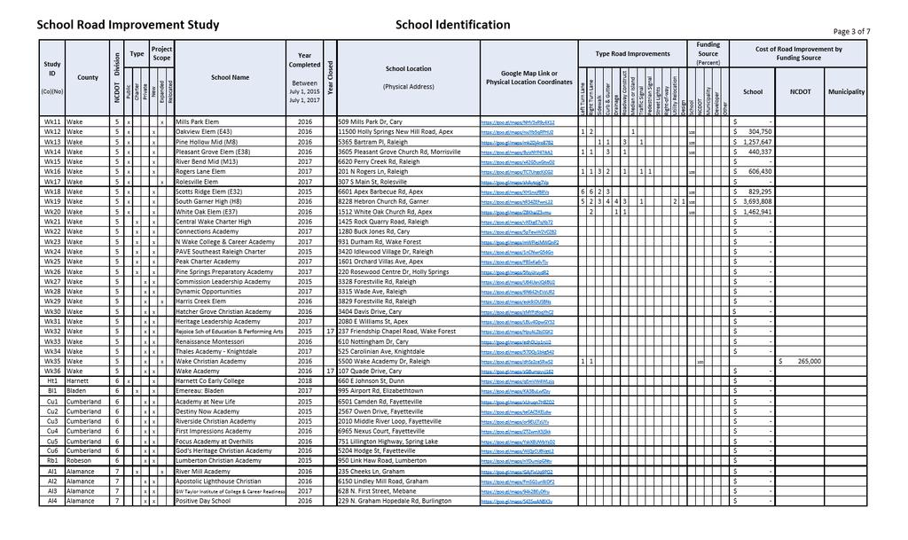
29 School Road Improvement Study School Identification Page 1 of 7 Study ID (Co)(No) County NCDOT Division Public Type Charter Private Project Scope New Expanded Relocated School Name Year Completed Between July 1, 2015 July 1, 2017 Year Closed School Location (Physical Address) Google Map Link or Physical Location Coordinates Type Road Improvements Bt1 Bertie 1 x x Freedom Academy Hexlena Road, Aulander $ - Cd1 Camden 1 x x Camden Early College High A US Highway 158 West, Camden $ - Nn1 Northampton 1 x x Northampton High Early College NC 46 HWY West, Gaston $ - Pk1 Pasquotank 1 x x Elizabeth City Pasquotank Early College N Road St, Elizabeth City $ - Pk2 Pasquotank 1 x x NE Acad of Aerospace & Advanced Tech Weeksvile Rd, Elizabeth City $ - Pk3 Pasquotank 1 x x Grace Montessori Academy Commercial Boulevard, Elizabeth City $ - Wa1 Washington 1 x x Washington Early College High NC Hwy 32 North, Roper $ - Ct1 Carteret 2 x x New Life Christian Academy Friendly Road, Morehead City $ - Cr1 Craven 2 x x Peletah Academic Center for Excellence Neuse Boulevard, New Bern $ - Cr2 Craven 2 x x Strait Path Academy Jonestown Road, Dover $ - Gr1 Greene 2 x x Covenant of Faith Christian Academy Hwy 123 North, Hookerton $ - Ln1 Lenoir 2 x x Miss Charlie's Child Develop. Center W. Vernon Ave, Kinston $ - Pm1 Pamlico 2 x x Gateway Christian Academy Hale Road, New Bern $ - Pt1 Pitt 2 x x East Carolina Laboratory School Howell St, Greenville $ - Pt2 Pitt 2 x x PCS Early College High Warren Drive, Winterville $ - Pt3 Pitt 2 x x Ignite Innovation Academy Staton Rd, Suite 204, Greenville $ 93,750 Pt4 Pitt 2 x x Winterville Charter Academy Bayswater Road, Winterville $ 175,000 Pt5 Pitt 2 x x Children's Montessori School Hungate Dr, Greenville $ - Pt6 Pitt 2 x x Children's World Academy East Arlington Blvd, Greenville $ - Pt7 Pitt 2 x x Deeper Life Academy Pitt Street, Grimesland $ - Pt8 Pitt 2 x x Stroke of Faith Academy NC 118, Grifton $ - Pt9 Pitt 2 x x Third Street Academy W Third Street, Greenville $ - Bk1 Brunswick 3 x x South Brunswick Charter Achievement Ave SE, Bolivia $ 819,125 Bk2 Brunswick 3 x x Canipe Academy Fairway Dr Boiling Spring Lakes, Southport $ - Dp1 Duplin 3 x x BF Grady Elementary North NC 11 / NC 903 Hwy, Albertson $ 95,850 Dp2 Duplin 3 x x Kenansville Elementary Limestone Rd, Kenansville $ - Dp3 Duplin 3 x x Rose Hill-Magnolia Elementary Brooks Quinn Rd, Rose Hill $ 64,600 Dp4 Duplin 3 x x Warsaw Elementary Lanefield Rd, Warsaw $ 1,081,250 Dp5 Duplin 3 x x Zelophehad's Daughters Christian Creekside Hills Dr, Magnolia $ - Jo1 Jones 3 x x Jones PK-12 School Highway 58, Trenton $ 505,625 Nh1 New Hanover 3 x x Porters Neck Elementary Edgewater Club Rd, Wilmington $ 210,000 Nh2 New Hanover 3 x x Coastal Preparatory Academy: CFA Pandion Dr, Wilmington $ - Nh3 New Hanover 3 x x Girls Leadership Acad of Wilmington South College Rd, Wilmington $ - Nh4 New Hanover 3 x x SEA-Tech High Blue Clay Road, Castle Hayne $ - Nh5 New Hanover 3 x x Temporary Sidbury Road Elementary Sidbury Road, Castle Hayne $ 334,375 Nh6 New Hanover 3 x x Peace Rose Montessori School Wrightsville Ave, Wilmington $ - Os1 Onslow 3 x x Onslow Early College Western Blvd, Jacksonville $ - Os2 Onslow 3 x x Abundant Life Christian Academy Gumbranch Road, Jacksonville $ - Os3 Onslow 3 x x Grace Classical School Pine Valley Rd, Jacksonville $ - Os4 Onslow 3 x x North Shore Academy NC Hwy 210, Sneads Ferry $ - Left Turn Lane Right Turn Lane Sidewalk Curb & Gutter Drainage Roadway Construct Median or Island Traffic Signal Pedestrian Signal Street Lights Right-of-way Utility Relocation Design School Funding Source (Percent) NCDOT Municipality Developer Other Cost of Road Improvement by Funding Source School NCDOT Municipality

30
31

32

33

34

35
36 APPENDIX B Road Improvement Details Tables of Identified New, Expanded or Relocated School Sites with Identified Road Improvement Details July 1, 2015 to July 1, P age

37 28 P age
38 29 P age

39 30 P age
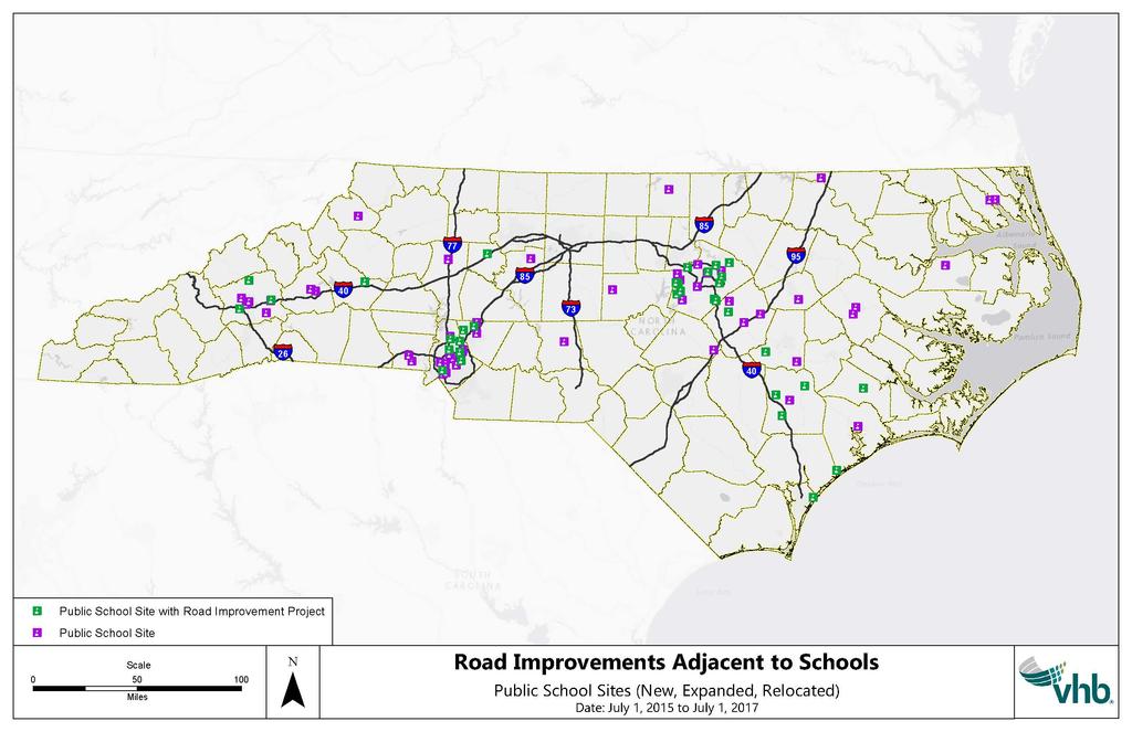
40 APPENDIX C GIS Maps Maps of Identified New, Expanded or Relocated School Sites Public, Charter and Private July 1, 2015 to July 1, P age
41
42
43
44 APPENDIX D Example Design and Construction Time Frames for Major School Construction Projects Example of Reported Wake County Design and Construction Phases Pleasant Grove Elementary (E-38) Oakview Elementary (E-43) Beaverdam Elementary (E-36) South Garner High (H-8) White Oak Elementary (E-37) Start Design Phase Notice to Proceed Construction Phase Completed Design Phase Construction Phase Total Design to Completion of Construction (begin of Construction Phase) (in days) (in days) (in days) Approximate Number of Project Months 3/18/14 4/22/15 8/1/ /8/14 5/6/15 7/29/ /16/14 6/3/15 7/25/ /14/13 6/19/14 7/18/ /17/14 5/20/15 7/18/ Green Elementary 8/23/13 1/26/15 6/1/ Pine Hollow Middle (M-8) Scotts Ridge Elementary (E-32) Abbotts Creek Elementary (E-20) 4/2/13 10/14/14 5/15/ /13/13 6/18/14 8/3/ /20/13 6/18/14 7/29/ Apex Friendship High 2/8/12 5/8/13 6/9/ Richland Creek Elementary 12/21/11 4/10/13 6/10/ Wake Young Women's Leadership Academy Wake Young Men's Leadership Academy 2/12/12 1/9/13 8/1/ /24/12 1/2/13 8/1/ Rolesville High 7/16/10 6/9/11 7/1/ Average Avg. Years Wake County Design and Construction Phases 35 P age
45 APPENDIX E Resources and Links References Links to Organize Legislation Reference: Senate Bill 257: Session Law [Appropriation Act of 2017] bmitbutton=go Fiscal Research Statement for Senate Bill 778 (2016) North Carolina Department of Public Instruction: NC DPI Educational Directory & Demographical Information Exchange NC DPI School Planning Section North Carolina Office of Charter Schools North Carolina Department of Administration: NC Division of Non-Public Education NC Directory of Private Schools 36 P age
46 APPENDIX F Road Improvements Adjacent To Schools Section 34.6A.(c) The Department of Transportation, in collaboration with the Department of Public Instruction, shall develop a report covering the period from July 1, 2015, through July 1, 2017, that provides all of the following information: (1) All schools, including private and charter, that have been opened, relocated, or expanded. (2) The types of road improvements required for each school identified in subdivision (1) of this subsection. (3) Whether each road improvement identified in subdivision (2) of this subsection is to a road maintained by the State or a municipality. (4) Whether each road improvement identified in subdivision (2) of this subsection is to a road adjacent to the school property. (5) A description of any disputes or appeals raised by the schools identified in subdivision (1) of this subsection concerning the road improvements identified in subdivision (2) of this subsection. (6) The total cost for each road improvement identified under subdivision (2) of this subsection. (7) The funding source for the payment of the costs incurred for each road improvement identified in subdivision (2) of this subsection. Road Improvements Adjacent To Schools Section 34.6A.(d) In addition to the information required under subdivisions (1) through (5) of subsection (c) of this section, and for the period covering July 2, 2017 through July 1, 2020, the report required under subsection (c) of this section shall identify (i) the number of schools, including private and charter, that will be opened, relocated, or expanded, (ii) the types of road improvements anticipated to be required for each school identified, and (iii) the total cost for each road improvement anticipated to be required for each school identified. Road Improvements Adjacent To Schools Section 34.6A.(e) The Department of Transportation shall submit the report required under subsection (c) of this section to the Joint Legislative Transportation Oversight Committee and the Joint Legislative Education Oversight Committee by February 1, P age
METHODOLOGY. Signalized Intersection Average Control Delay (sec/veh)
") Chapter 5 Traffic Analysis 5.1 SUMMARY US /West 6 th Street assumes a unique role in the Lawrence Douglas County transportation system. This principal arterial street currently conveys commuter traffic
Chapter 5 Traffic Analysis 5.1 SUMMARY US /West 6 th Street assumes a unique role in the Lawrence Douglas County transportation system. This principal arterial street currently conveys commuter traffic
Traffic Impact Analysis Walton Acres at Riverwood Athletic Club Clayton, NC
 Traffic Impact Analysis Walton Acres at Riverwood Athletic Club Clayton, NC 1. TABLE OF CONTENTS INTRODUCTION...1 1.1. Site Location and Study Area...1 1.2. Proposed Land Use and Site Access...2 1.3.
Secondary Road Program
 Secondary Road Program Joint Legislative Transportation Oversight Committee October 5, 2012 1 Secondary Roads Program The Big Picture The Secondary Road System Needs and Project Types Paved and Unpaved
City of Wayzata Comprehensive Plan 2030 Transportation Chapter: Appendix A
 A1. Functional Classification Table A-1 illustrates the Metropolitan Council s detailed criteria established for the functional classification of roadways within the Twin Cities Metropolitan Area. Table
Project Update May 2018
 Project Update May 2018 Dakota County, in cooperation with the City of Lakeville, is planning to reconstruct 202 nd Street West (County Road 50) from Holyoke Avenue to Cedar Avenue (County Road 23). 202
Traffic Impact Study. Westlake Elementary School Westlake, Ohio. TMS Engineers, Inc. June 5, 2017
 TMS Engineers, Inc. Traffic Impact Study Westlake Elementary School Westlake, Ohio June 5, 2017 Prepared for: Westlake City Schools - Board of Education 27200 Hilliard Boulevard Westlake, OH 44145 TRAFFIC
ARTINSVILLE ENRY OUNTY REA RANSPORTATION TUDY
 ARTINSVILLE ENRY OUNTY REA RANSPORTATION TUDY DEVELOPED BY THE TRANSPORTATION AND MOBILITY PLANNING DIVISION OF THE VIRGINIA DEPARTMENT OF TRANSPORTATION IN COOPERATION WITH THE U.S. DEPARTMENT OF TRANSPORTATION,
TRASBURG RANSPORTATION
 TRASBURG RANSPORTATION LAN DEVELOPED BY THE TRANSPORTATION PLANNING DIVISION OF THE VIRGINIA DEPARTMENT OF TRANSPORTATION IN COOPERATION WITH THE U.S. DEPARTMENT OF TRANSPORTATION, FEDERAL HIGHWAY ADMINISTRATION
Highway 49, Highway 351 and Highway 91 Improvements Feasibility Study Craighead County
 Highway 49, Highway 351 and Highway 91 Improvements Feasibility Study Craighead County Executive Summary March 2015 Highway 49, Highway 351 and Highway 91 Improvements Feasibility Study Craighead County
Building Great Neighbourhoods BELLEVUE AND VIRGINIA PARK
 Building Great Neighbourhoods BELLEVUE AND VIRGINIA PARK This is Meeting 2 Unfortunately, some residents in Bellevue and Virginia Park received the wrong information for this public open house (Meeting
TRANSPORTATION & INDUSTRIAL ACCESS STUDY PHASE II GENESEE TRANSPORTATION COUNCIL
 TRANSPORTATION & INDUSTRIAL ACCESS STUDY PHASE II GENESEE TRANSPORTATION COUNCIL MONROE COUNTY VILLAGE SQUARE FINAL CONCEPT-LEVEL STRATEGY REPORT I. Introduction The purpose of this report is to recommend
Welcome. Thank you for your interest in the Lewis & Clark Viaduct Concept Study
 Welcome Thank you for your interest in the Lewis & Clark Viaduct Concept Study Please use the arrows in the upper left hand corner to navigate through the presentation. Use the envelope icon to ask a question
FM 1092/Murphy Road Access Management Study Pulic Meeting #1. Wednesday, August 31, :00 p.m. 8:00 p.m.
 FM 1092/Murphy Road Access Management Study Pulic Meeting #1 Wednesday, August 31, 2011 6:00 p.m. 8:00 p.m. Introductions Agency Partners H-GAC Missouri City TxDOT Introductions Consulting Team In Association
6.0 PEDESTRIAN AND BICYCLE FACILITIES 6.1 INTRODUCTION 6.2 BICYCLE DEMAND AND SUITABILITY Bicycle Demand
 6.0 PEDESTRIAN AND BICYCLE FACILITIES 6.1 INTRODUCTION Bicycle and pedestrian travel along and in the vicinity of the corridor is part of the vision of Somerset and Hunterdon counties and the integrated
JONESBORO HIGHWAY 63 HIGHWAY 18 CONNECTOR STUDY
 JONESBORO HIGHWAY 63 HIGHWAY 18 CONNECTOR STUDY Craighead County May 2007 JONESBORO HIGHWAY 63 HIGHWAY 18 CONNECTOR STUDY Craighead County May 2007 Prepared by Planning and Research Division Arkansas State
3.0 Future Conditions
 3.0 Future Conditions In order to be able to recommend appropriate improvements to the transportation system of the Town, it is important to first understand the nature and volume of traffic that is expected
Multimodal Through Corridors and Placemaking Corridors
 68 Multimodal Through Corridors and Placemaking Corridors Corridors have different functions in a region. Some corridors are used to get smoothly and rapidly through a region or to get quickly to major
Driveway Design Criteria
 Design Manual Chapter 5 - Roadway Design 5L - Access Management 5L-4 Driveway Design Criteria A. General For efficient and safe operations, access drives and minor public street intersections can be improved
Building Great Neighbourhoods LANSDOWNE
 Building Great Neighbourhoods LANSDOWNE We are here today to Explain how the City is investing in improving your neighbourhood and how your neighbourhood will be improved to meet current City standards.
2.0 LANE WIDTHS GUIDELINE
 2.0 LANE WIDTHS GUIDELINE Road Engineering Design Guidelines Version 2.0.1 May 2018 City of Toronto, Transportation Services City of Toronto Page 0 Background In early 2014, Transportation Services initiated
Corpus Christi Metropolitan Transportation Plan Fiscal Year Introduction:
 Introduction: The Safe, Accountable, Flexible, Efficient Transportation Equity Act: A Legacy for Users (SAFETEA-LU) has continued the efforts started through the Intermodal Surface Transportation Efficiency
CHAPTER 7 ACCESS MANAGEMENT. Background. Principles of Access Management. Hennepin County Transportation Systems Plan (HC-TSP)
") CHAPTER 7 ACCESS MANAGEMENT Background Principles of Access Management Hennepin County Transportation Systems Plan (HC-TSP) Chapter 7 Access Management 7.1 Background Access management has become an important
CHAPTER 7 ACCESS MANAGEMENT Background Principles of Access Management Hennepin County Transportation Systems Plan (HC-TSP) Chapter 7 Access Management 7.1 Background Access management has become an important
West Dimond Blvd Upgrade Jodhpur Street to Sand Lake Road
 West Dimond Blvd Jodhpur St to Sand Lake CSS Transportation Project Summary Municipality of Anchorage Project # 05 005 Project Manager: John Smith, P.E. (MOA PM&E) Project Administrator: Julie Makela,
Building Great Neighbourhoods BONNIE DOON
 Building Great Neighbourhoods BONNIE DOON We Are Here Today To Explain the Neighbourhood Renewal Process Show you the Westwood Preliminary Design Ask for local knowledge Highlight the Local Improvement
Basalt Creek Transportation Refinement Plan Recommendations
 Basalt Creek Transportation Refinement Plan Recommendations Introduction The Basalt Creek transportation planning effort analyzed future transportation conditions and evaluated alternative strategies for
City of Homewood Transportation Plan
 City of Homewood Transportation Plan Prepared for: City of Homewood, Alabama Prepared by: Skipper Consulting, Inc. May 2007 TABLE OF CONTENTS INTRODUCTION... 1 BACKGROUND INFORMATION... 1 EXISTING TRANSPORTATION
Roadway Design Manual
 Roadway Design Manual Manual Notice Archive by Texas Department of Transportation (512) 302-2453 all rights reserved Manual Notice 2009-1 From: Manual: Mark A. Marek, P.E Roadway Design Manual Effective
Street Paving and Sidewalk Policy
 City Commission Policy 600 Street Paving and Sidewalk Policy DEPARTMENT: Public Works DATE ADOPTED: June 7, 1995 DATE OF LAST REVISION: December 10, 2014 Policy No. 600.01 AUTHORITY: PASS City of Tallahassee-Leon
Building Great Neighbourhoods QUEEN ALEXANDRA
 Building Great Neighbourhoods QUEEN ALEXANDRA We are here today to Explain how the City is investing in improving your neighbourhood and how your neighbourhood will be improved to meet current City standards.
Recommended Roadway Plan Section 2 - Land Development and Roadway Access
 Recommended Roadway Plan Section 2 - Land Development and Roadway Access SECTION 2 Land Development and Roadway Access 2.1 Land Use and Access Management The Federal Highway Administration (FHWA) defines
Access requests to County streets and roadways are processed through one of the following methods:
 13.1 GENERAL APPLICATION PROCESS Access requests to County streets and roadways are processed through one of the following methods: A. Planned Developments may set general locations for access points.
ADOT Statewide Bicycle and Pedestrian Program Summary of Phase IV Activities APPENDIX B PEDESTRIAN DEMAND INDEX
 ADOT Statewide Bicycle and Pedestrian Program Summary of Activities APPENDIX B PEDESTRIAN DEMAND INDEX May 24, 2009 Pedestrian Demand Index for State Highway Facilities Revised: May 29, 2007 Introduction
This Chapter sets forth the minimum design, technical criteria and specifications to be used in the preparation of all roadway plans.
 4.1 GENERAL This Chapter sets forth the minimum design, technical criteria and specifications to be used in the preparation of all roadway plans. These Roadway Standards are for new construction and modification
WELCOME TO OPEN HOUSE # 1 June 14, 2017
 Langstaff Road Weston Road to Highway 7 Class Environmental Assessment Study WELCOME TO OPEN HOUSE # 1 June 14, 2017 Please sign in and join our mailing list Purpose of Open House #1 & Study Area York
Transportation Master Plan Advisory Task Force
 Transportation Master Plan Advisory Task Force Network Alternatives & Phasing Strategy February 2016 BACKGROUND Table of Contents BACKGROUND Purpose & Introduction 2 Linking the TMP to Key Council Approved
SECTION 5: PEER CITY REVIEW
 SECTION 5: PEER CITY REVIEW 5.1 Introduction It is evident that the City of Lincoln continually strives to improve its operations and practices. To that end, a list of peer cities was developed to compare
CITY OF KASSON TRANSPORTATION ALTERNATIVES KASSON SAFE ROUTES TO SCHOOL
 ve ha 8t G B A Mantorville Ave N 240th Ave 16th St NE 11th Ave NE K-M HIGH SCHOOL SUNRISE TRAIL TO MANTORVILLE MNTH 57 SUNSET TRAIL TO MANTORVILLE NE PARK 16TH ST NE TRAIL K-M ELEMENTARY SCHOOL K-M MIDDLE
Traffic Impact Analysis Chatham County Grocery Chatham County, NC
 Chatham County Grocery Chatham County, NC TABLE OF CONTENTS 1. INTRODUCTION... 1 1.1. Location and Study Area... 1 1.2. Proposed Land Use and Access... 2 1.3. Adjacent Land Uses... 2 1.4. Existing ways...
HIGHWAY 11 CORRIDOR STUDY
 HIGHWAY 11 CORRIDOR STUDY Executive Summary August 2016 Roseau County?æA@?çA@ Warroad Lake of the Woods Roseau Roosevelt Badger?ÄA@ Greenbush Legend N Hwy 11 Study Area Figure 1: Corridor Study Limits
TRAFFIC STUDY GUIDELINES Clarksville Street Department
 TRAFFIC STUDY GUIDELINES Clarksville Street Department 9/1/2009 Introduction Traffic studies are used to help the city determine potential impacts to the operation of the surrounding roadway network. Two
Chapter 14 PARLIER RELATIONSHIP TO CITY PLANS AND POLICIES. Recommendations to Improve Pedestrian Safety in the City of Parlier (2014)
") Chapter 14 PARLIER This chapter describes the current status and future plans for biking and walking in the City of Parlier. RELATIONSHIP TO CITY PLANS AND POLICIES The Parlier General Plan is the primary
Chapter 14 PARLIER This chapter describes the current status and future plans for biking and walking in the City of Parlier. RELATIONSHIP TO CITY PLANS AND POLICIES The Parlier General Plan is the primary
Citizens Handbook for Requesting Traffic Calming Devices
 Citizens Handbook for Requesting Traffic Calming Devices January 19, 2015 Table of Contents 1. PURPOSE... - 1-2. DEFINITIONS... - 2-3. GENERAL INFORMATION... - 3-3.1. ELIGIBILITY REQUIREMENTS... - 3-3.2.
DRAFT BUENA VISTA 2020 TRANSPORTATION PLAN
 DRAFT BUENA VISTA 2020 TRANSPORTATION PLAN DEVELOPED BY THE TRANSPORTATION PLANNING DIVISION OF THE VIRGINIA DEPARTMENT OF TRANSPORTATION IN COOPERATION WITH THE U.S. DEPARTMENT OF TRANSPORTATION, FEDERAL
Design Criteria. Design Criteria
 F Design Criteria Design Criteria Ministry of Transportation Ministère des Transports DESIGN CRITERIA Page: 1 of 13 WORK PROJECT NO. N/A GO Bloomington Station TYPE OF PROJECT LOCATION Bloomington Road
APPENDIX G: INTERSECTION NEEDS AT OKEECHOBEE BOULEVARD
 APPENDIX G: INTERSECTION NEEDS AT OKEECHOBEE BOULEVARD INTERSECTION NEEDS AT SR 7 and OKEECHOBEE BOULEVARD SR 7 Extension Project Development and Environment (PD&E) Study From Okeechobee Boulevard (SR
Proposed Action, Purpose and Need Technical Memorandum
 Proposed Action, Purpose and Need Technical Memorandum MoPac (State Loop 1) Intersections, Austin District From North of Slaughter Lane to South of La Crosse Avenue CSJ: 3136-01-015 Travis County, Texas
Chapter 13 ORANGE COVE
 Chapter 13 ORANGE COVE This chapter describes the current status and future plans for biking and walking in the City of Orange Cove. RELATIONSHIP TO CITY PLANS AND POLICIES The Orange Cove General Plan
Access Management Regulations and Standards
 Access Management Regulations and Standards January 2014 Efficient highway operation Reasonable property access Concept of Access Management The way to manage access to land development while preserving
DUNBOW ROAD FUNCTIONAL PLANNING
 DUNBOW ROAD FUNCTIONAL PLANNING Final Report August 3, 216 #31, 316 5th Avenue NE Calgary, AB T2A 6K4 Phone: 43.273.91 Fax: 43.273.344 wattconsultinggroup.com Dunbow Road Functional Planning Final Report
4.0 TRAFFIC IMPACT STUDIES
 SECTION 4 4.0 TRAFFIC IMPACT STUDIES 4.1 TRAFFIC IMPACT STUDY REQUIREMENTS The City has established Traffic Impact Study (TIS) requirements for the purpose of ensuring that both the quantitative and qualitative
ADA Transition Plan. City of Gainesville FY19-FY28. Date: November 5, Prepared by: City Of Gainesville Department of Mobility
 ADA Transition Plan FY19-FY28 Date: November 5, 2018 Prepared by: City Of Gainesville Department of Mobility 1.0 INTRODUCTION 1.1 BACKGROUND The federal statute known as the Americans with Disabilities
Transportation Impact Study for Abington Terrace
 Transportation Impact Study for Abington Terrace Abington Township, Montgomery County, PA Sandy A. Koza, P.E., PTOE PA PE License Number PE059911 Prepared by McMahon Associates, Inc. 425 Commerce Drive,
Pedestrian Crosswalk Audit
 1200, Scotia Place, Tower 1 10060 Jasper Avenue Edmonton, Alberta T5J 3R8 edmonton.ca/auditor Pedestrian Crosswalk Audit June 19, 2017 The conducted this project in accordance with the International Standards
Environmental Assessment Findings & Recommendations. Public Hearing November 13, 2014
 Environmental Assessment Findings & Recommendations Public Hearing November 13, 2014 Welcome! Welcome and Introductions Project and Environmental Assessment Overview Public Comments Adjourn Purpose of
Access Management Regulations and Standards
 Access Management Regulations and Standards Efficient highway operation Reasonable property access Concept of Access Management The way to manage access to land development while simultaneously preserving
ACTIVE TRANSPORTATION
 ACTIVE TRANSPORTATION Mobility 2040 Supported Goals Improve the availability of transportation options for people and goods. Support travel efficiency measures and system enhancements targeted at congestion
1.0 EXECUTIVE SUMMARY
 1.0 EXECUTIVE SUMMARY The Active Transportation Plan is a guide to accomplish the Town s vision for developing a network of sidewalks, on-road bicycle facilities, and trails that allow for safe and convenient
SNCC Demographic Trends
 Employment Population SNCC Demographic Trends In 1970 the SNCC population was 10,040, accounting for roughly 3% of the County population In 2015, SNCC grew to 60,567 people, roughly 11% of the County population
INNER LOOP EAST. AIA Rochester Annual Meeting November 13, 2013 TRANSFORMATION PROJECT. Bret Garwood, NBD Erik Frisch, DES
 INNER LOOP EAST TRANSFORMATION PROJECT AIA Rochester Annual Meeting November 13, 2013 Bret Garwood, NBD Erik Frisch, DES Why? We are building a city that encourages walking, biking and enjoying the outdoor
SECTION 3 STREET DESIGN
 3.01 GENERAL SECTION 3 STREET DESIGN For purposes of geometric and structural design, streets shall be classified according to the following table. The City Engineer will determine the class of all proposed
FY 2018 TRANSPORTATION CAPITAL PROGRAM New Jersey Department of Transportation Projects
 Camden County Bus Purchase Project ID Numbers: D0601 / 068082 In the DVRPC region, a combination of fixed route, subscription, and demand responsive transit services are provided in Camden County by Senior
Traffic Impact Study WestBranch Residential Development Davidson, NC March 2016
 Traffic Impact Study WestBranch Residential Development Davidson, NC March 216 TRAFFIC IMPACT STUDY FOR THE WestBranch Residential Development LOCATED IN DAVIDSON, NC Prepared For: Lennar Carolinas, LLC
10.0 CURB EXTENSIONS GUIDELINE
 10.0 CURB EXTENSIONS GUIDELINE Road Engineering Design Guidelines Version 1.0 March 2017 City of Toronto, Transportation Services City of Toronto Page 0 Background In early 2014, Transportation Services
M-58 HIGHWAY ACCESS MANAGEMENT STUDY Mullen Road to Bel-Ray Boulevard. Prepared for CITY OF BELTON. May 2016
 M-58 HIGHWAY ACCESS MANAGEMENT STUDY Prepared for CITY OF BELTON By May 2016 Introduction Missouri State Highway 58 (M-58 Highway) is a major commercial corridor in the City of Belton. As development has
Zebulon Multimodal Transportation Plan Update
 Zebulon Multimodal Transportation Plan 2035 Update March 2014 This page intentionally left blank. Table of Contents Section 1: Introduction... 1-1 Study Purpose: Updating the Existing Plan... 1-1 Study
Traffic Impact Memorandum. May 22, 2018
 BISHOP PROFESSIONAL DEVELOPMENT BUILDING Proposed Land-use Change & Parking Modification 3601 SW 31st Street Topeka, Kansas 66614 CFS Project No. 185077 Traffic Impact Memorandum May 22, 2018 Prepared
CITY OF VAUGHAN EXTRACT FROM COUNCIL MEETING MINUTES OF OCTOBER 30, 2012
 CITY OF VAUGHAN EXTRACT FROM COUNCIL MEETING MINUTES OF OCTOBER 30, 2012 Item 31, Report No. 39, of the Committee of the Whole, which was adopted without amendment by the Council of the City of Vaughan
Legislative Update Williamsburg Residency
 Hampton Roads District Legislative Update Williamsburg Residency Jim Brewer, Resident Administrator 757-253-5140 Projects Under Way Warwick Boulevard Project http://www.warwickboulevard.org/ Contractors:
EXECUTIVE SUMMARY OF CALEDON TRANSPORTATION NEEDS STUDY
 EXECUTIVE SUMMARY OF CALEDON TRANSPORTATION NEEDS STUDY The Caledon Transportation Needs Study has been undertaken as a joint project by the Town of Caledon and the Region of Peel to determine the existing
Reams Road RCA Study. Board of County Commissioners Public Hearing
 Reams Road RCA Study Board of County Commissioners Public Hearing April 24, 2018 Presentation Overview Study Overview Existing Conditions Development of Alternatives Preferred Alternative Public Involvement
DES MOINES AREA MPO. Presentation to Iowa Commercial Real Estate Association. April 6, 2017
 DES MOINES AREA MPO Presentation to Iowa Commercial Real Estate Association April 6, 2017 Presentation Outline MPO Overview Trends We re Watching Plans, Projects, Initiatives, Regional Transportation Priorities
Executive Summary June 2015
 Executive Summary June 2015 Highway 112 Corridor Study Benton and Washington Counties Executive Summary June 2015 Prepared by Transportation Planning and Policy Division Arkansas State Highway and Transportation
CITY OF COCOA BEACH 2025 COMPREHENSIVE PLAN. Section VIII Mobility Element Goals, Objectives, and Policies
 CITY OF COCOA BEACH 2025 COMPREHENSIVE PLAN Section VIII Mobility Element Goals, Objectives, and Policies Adopted August 6, 2015 by Ordinance No. 1591 VIII MOBILITY ELEMENT Table of Contents Page Number
900 BICYCLE FACILITIES Traffic Engineering Manual
 TABLE OF CONTENTS Part 9 - BICYCLE FACILITIES 900 GENERAL... 9-3 900-1 General Background... 9-3 900-2 Designated Bicycle Routes... 9-3 901 SIGNINGS... 9-4 902 MARKINGS... 9-4 902-1 General... 9-4 902-2
Final Sidewalk Feasibility Study
 Garfield Drive From Anastasia Drive to Elizabeth Place City of South Daytona July 23, 2009 Final Sidewalk Feasibility Study Prepared for: Prepared by: Final Sidewalk Feasibility Study Garfield Drive 2
Chapter 4 Traffic Analysis
 Chapter 4 Traffic Analysis PURPOSE The traffic analysis component of the K-68 Corridor Management Plan incorporates information on the existing transportation network, such as traffic volumes and intersection
Traffic Impact Analysis (TIA) Process and Procedures Manual. September 2017
 Process and Procedures Manual. September 2017") Traffic Impact Analysis (TIA) Process and Procedures Manual Post Office Box 664 101 Huntersville-Concord Road Huntersville, NC 28070 Phone 704-766-2220 Fax 704-992-5528 www.huntersville.org (c) 2017, Town
Traffic Impact Analysis (TIA) Process and Procedures Manual Post Office Box 664 101 Huntersville-Concord Road Huntersville, NC 28070 Phone 704-766-2220 Fax 704-992-5528 www.huntersville.org (c) 2017, Town
The District Municipality of Muskoka 70 Pine Street Bracebridge ON P1L 1N3
 Public Information Centre Summary Report Muskoka Road 15 (Santa s Village Road) Transportation Improvements from the Beaver Creek Bridge to the Entrance of Santa s Village The District Municipality of
Building Great Neighbourhoods STRATHEARN
 Building Great Neighbourhoods STRATHEARN Public Involvement Community League Meeting #1: October 5, 2015 Public Meeting #2: March 15, 2016 Public Meeting #3: January 17, 2017 Building Great Neighbourhoods
CITY OF WEST LAKE HILLS. Forest View Neighborhood Traffic Calming Study
 CITY OF WEST LAKE HILLS 901 South Mopac Expressway Building V, Suite 220 Austin, Texas 78746 Texas P.E. Firm Registration No. F-929 Klotz Associates Final Report Submittal: March 20, 2015 Revised Final
4. Action Plan & Projects
 4. Action Plan & Projects 45 46 ACTION PLAN AND PROJECTS The Action Plan organizes the list of transportation projects described in the Mobility Framework Plan section into short-term (0-5 years) and long-term
PennDOT Access Management Model Ordinances Training
 PennDOT Access s Training Trainers: Chad Dixson, AICP, TPD Angela Watson, PB Objective of Today Assist Pennsylvania s municipalities and transportation professionals in better understanding the benefits
WEST AND SOUTH WEST RING ROAD DOWNSTREAM TRAFFIC IMPACTS
 Page 1 of 9 EXECUTIVE SUMMARY Alberta Transportation ( AT ) is preparing to construct the final sections of the Calgary Ring Road. This includes the South West Ring Road ( SWRR ) (from Lott Creek Blvd
Access Location, Spacing, Turn Lanes, and Medians
 Design Manual Chapter 5 - Roadway Design 5L - Access Management 5L-3 Access Location, Spacing, Turn Lanes, and Medians This section addresses access location, spacing, turn lane and median needs, including
Small Area Study U.S. Route 220 and VA Route 615 Intersection. Bath County, Virginia
 Small Area Study U.S. Route 220 and VA Route 615 Intersection Bath County, Virginia Prepared by the Central Shenandoah Planning District Commission Final Report February 2018 Table of Contents 1. INTRODUCTION...
MAG Town of Cave Creek Bike Study Task 6 Executive Summary and Regional Significance Report
 Page 1 MAG Town of Cave Creek Bike Study Task 6 Executive Summary and Regional Significance Report August 1, 2012 MAG Project #481 Page 2 Task 6 Executive Summary and Regional Significance Report Introduction
Access Management Standards
 Access Management Standards Section 1: Application of Access Standards This chapter describes the Department's access management standards for access connections on the county roadway system. The standards
Municipal and School PROUD TO SERVE. Transportation Assistance
 Municipal and School PROUD TO SERVE Transportation Assistance MSTA School Traffic Calculator To help insure school systems incorporate transportation safety in future designs, state law requires schools
Intersection Traffic Control Feasibility Study
 Intersection Traffic Control Feasibility Study CSAH 9 at CSAH 60 (185th Avenue) Prepared For: Dakota County Transportation Department Western Service Center 14955 Galaxie Avenue, 3rd Floor Apple Valley,
Bluffdale/ UDOT South High-T Intersection Project Type Operations
 Bluffdale/ UDOT 14600 South High-T Intersection Project Type Operations 14600 South and Redwood Road $ 600,000 $ 550,000 This project is to install a new High-T intersection at Redwood Road and 14600 South
MEMORANDUM TERESA MCCLISH, COMMUNITY DEVELOPMENT DIRECTOR SUBJECT: CONSIDERATION OF RESTRICTING PARKING ADJACENT TO 170 AND 171 BRISCO ROAD
 MEMORANDUM TO: FROM: BY: TRAFFIC COMMISSION TERESA MCCLISH, COMMUNITY DEVELOPMENT DIRECTOR MATT HORN, CITY ENGINEER SUBJECT: CONSIDERATION OF RESTRICTING PARKING ADJACENT TO 170 AND 171 BRISCO ROAD DATE:
Memorandum. Drive alone
 Memorandum To: Cc: From: Kimberly Kerr, Assistant Chief Administrative Officer Natalie Porter, PE, TE Shawna Purvines Claudia Wade, PE Michael Schmitt, AICP CTP, PTP Re: Technical Memorandum #2: Model
Mark Malone, P.E. SD DOT
 Mark Malone, P.E. SD DOT SD10 Grading & Surfacing From 8 th Ave W to 8 th Ave E 1 mile plus transition lengths Complete Urban Reconstruction Grading, C&G, Storm Sewer, Sidewalk, Concrete Surfacing Railroad
Magnolia Place. Traffic Impact Analysis. Prepared for: City of San Mateo. Prepared by: Hexagon Transportation Consultants, Inc.
 Magnolia Place Traffic Impact Analysis Prepared for: City of San Mateo Prepared by: Hexagon Transportation Consultants, Inc. Updated January 4, 2010 Table of Contents 1. Introduction...1 2. Existing Conditions...6
Town of Siler City - Unified Development Ordinance ARTICLE XIV - Streets and Sidewalks
 ARTICLE XIV - Streets and Sidewalks 193 Street Classification (a) In all new subdivisions, streets that are dedicated to public use shall be classified as provided in 193(b) (1) The classification shall
Brian McHugh, Buckhead Community Improvement District. SUBJECT: Wieuca Road at Phipps Boulevard Intersection Improvements Project
 MEMO TO: FROM: Brian McHugh, Buckhead Community Improvement District Jagan Kaja, AICP, WSP Parsons Brinckerhoff SUBJECT: Wieuca Road at Phipps Boulevard Intersection Improvements Project DATE: October
TOWN OF CHAPEL HILL POLICY AND PROCEDURES FOR TRAFFIC CALMING MEASURES
 TOWN OF CHAPEL HILL POLICY AND PROCEDURES FOR TRAFFIC CALMING MEASURES (Adopted by the Town Council on June 30, 2004) (Revised December 6, 2010) (Revised February 8, 2016) POLICY AND PROCEDURES FOR TRAFFIC
DALLAS MIDTOWN REDEVELOPMENT PLAN FOCUS NORTH TEXAS Peer Chacko, AICP, Assistant Director, City of Dallas
 DALLAS MIDTOWN REDEVELOPMENT PLAN FOCUS NORTH TEXAS 2014 Peer Chacko, AICP, Assistant Director, City of Dallas Dallas Midtown: Strategic growth area Future transit node 2 Peterson Road Study Area Galleria
NORTH HIGHLAND LAKE ROAD PROJECT
 NORTH HIGHLAND LAKE ROAD PROJECT The purpose of this special newsletter is to inform the residents of Flat Rock about the facts concerning the proposed N. Highland Lake Road Project and clarify some misconceptions.
Welcome to the Open House
 Leslie Street Between 19 th Avenue and Stouffville Road Addendum to Class Environmental Assessment Study Welcome to the Open House Please sign in at the front desk. March 28, 2017 Richmond Green Sports