September 2010 Review Project Concepts SCHEMATIC DESIGN NEGOTIATION CONSTRUCTION
|
|
|
- Shannon Hicks
- 5 years ago
- Views:
Transcription
1 VII. STANDING COMMITTEES F 10 B. Finance, Audit and Facilities Committee Montlake Triangle Project (formerly Rainier Vista Pedestrian Land Bridge) Adopt Project Budget, Approve UW Funding Commitment, Approve the Use of Alternative Public Works, Delegate Authority to Sign a Memorandum of Agreement, Delegate Authority to Sign Construction Contract(s), and Review Schematic Design (for information only) September 2010 Review Project Concepts February 2011 Review Schematic Design Regents Action and Information Review Timeline INFORMATION PHASES ACTION PREDESIGN SCHEMATIC DESIGN NEGOTIATION CONSTRUCTION February 2011 Adopt the Project Budget Approve UW Funding Commitment Approve the use of Alternative Public Works Delegate Authority to Sign MOA and Construction Contract(s) Note for duration of project: Written semi-annual reports in December & June Oral semi-annual updates in March & September RECOMMENDED ACTION: It is the recommendation of the administration and the Finance, Audit and Facilities Committee that the Board of Regents: 1) Adopt the Project Budget for the Montlake Triangle Project (MTP) at $38 million; 2) Approve a University of Washington funding commitment of $4 million; 3) Approve the use of Alternative Public Works (General Contractor/ Construction Manager - GC/CM); 4) Delegate authority to the President to sign a three party Memorandum of Agreement (MOA) between the Washington State Department of Transportation (WSDOT), Sound Transit (ST) and the University of Washington (UW); and 5) Delegate authority to the President to sign construction contract(s). PROJECT BACKGROUND: Sound Transit (ST) is required to have a grade separated crossing at the Burke Gilman Trail as part of the pedestrian access to and from the light rail station at F 10/ /17/11
2 VII. STANDING COMMITTEES B. Finance, Audit and Facilities Committee Montlake Triangle Project (formerly Rainier Vista Pedestrian Land Bridge) Adopt Project Budget, Approve UW Funding Commitment, Approve the Use of Alternative Public Works, Delegate Authority to Sign a Memorandum of Agreement, Delegate Authority to Sign Construction Contract(s), and Review Schematic Design (for information only) (continued p. 2) Husky Stadium and ensure improvement of non-motorized transportation connections between Montlake Boulevard (SR 513) and the Burke Gilman Trail. WSDOT is responsible for the completion and connectivity of the SR 520 regional trail system and, as such, serve as mitigation for effects resulting from the SR 520 I-5 to Medina project. Sound Transit s original UW approved solution was to provide a 710 foot long pedestrian bridge over Montlake Blvd, Pacific Place, and the Burke Gilman Trail to connect the station to the south end of Rainier Vista. During the permitting review, Seattle Department of Transportation (SDOT) requested a study be performed to see if there was an equal, if not better, alternative to the bridge. A committee comprised of ST, the UW and SDOT concluded there was indeed a better alternative that used the Rainier Vista Concept Plan (RVCP) as the basis of the design. In April 2010, the WSDOT SR 520 project announced their preferred alternate for the Montlake Triangle interchange which included portions of the University s RVCP. As part of the preferred alternate review process, additional criteria were introduced mandating all pedestrian crossing concepts be evaluated anew. The result was an agreement that a bridge from the transit station across Montlake boulevard with an incorporated bike ramp on the east side of Montlake onto the triangle was the best solution to accommodate WSDOT needs in addressing regional bike trail requirements. PROJECT DESCRIPTION: The scope of the Montlake Triangle Project (MTP) lowers NE Pacific Place and constructs a land bridge that will connect the Montlake triangle with the lower Rainier Vista in a seamless pedestrian experience. Transit patrons will access the triangle via a combination of existing crosswalks and a new mid-block bridge across Montlake connecting directly to the new ST University of Washington Station and Husky Stadium Plaza. The MTP will consist of three subprojects that will be constructed sequentially and scheduled to minimize impacting light rail tunnel and Husky Stadium F 10/ /17/11
3 VII. STANDING COMMITTEES B. Finance, Audit and Facilities Committee Montlake Triangle Project (formerly Rainier Vista Pedestrian Land Bridge) Adopt Project Budget, Approve UW Funding Commitment, Approve the Use of Alternative Public Works, Delegate Authority to Sign a Memorandum of Agreement, Delegate Authority to Sign Construction Contract(s), and Review Schematic Design (for information only) (continued p. 3) renovation haul routes designated by the City of Seattle. These subprojects consist of: Montlake Pedestrian Bridge: This subproject will be designed and constructed under the management of Sound Transit. ST will construct a new bridge from the light rail station head house to the Montlake Triangle replacing their originally approved pedestrian bridge. They will also construct a new bicycle accessible pedestrian ramp connecting to the public Montlake Blvd sidewalk south of the station headhouse. The budget for this subproject is set at $11.4 million. Rainier Vista Land Bridge Civil/Structural (RVLB): This subproject will be designed and constructed under the management of the UW. UW will lower NE Pacific Place, add light weight fill to raise the top of the Montlake Triangle, fill in the roadway which connects to the below grade entrance to the UW Triangle Garage northwest to Stevens Way and construct a land bridge connecting Rainier Vista to the Montlake Triangle. The budget for this subproject is set at $20.8 million. Rainier Vista Land Bridge landscaping, hardscaping and finishes: This subproject will be designed and constructed under the management of the UW. UW will install hardsurface pathways, lighting, irrigation, trees and shrubbery from Stevens Way along the lower Rainier Vista, over the land bridge, the top of the Montlake Triangle and under the land bridge along the newly lowered NE Pacific Place. The budget for this subproject is set at $4.5 million. PREVIOUS ACTIONS: Specific to the Montlake Triangle Project, there has been one previous item brought before the regents: September 2010 Review Project Concept Previous to that, the Rainier Vista Land Bridge Project, which is now incorporated into the MTP, was brought before the Regents on three occasions. However, these previous approvals are not applicable on the MTP. F 10/ /17/11
4 VII. STANDING COMMITTEES B. Finance, Audit and Facilities Committee Montlake Triangle Project (formerly Rainier Vista Pedestrian Land Bridge) Adopt Project Budget, Approve UW Funding Commitment, Approve the Use of Alternative Public Works, Delegate Authority to Sign a Memorandum of Agreement, Delegate Authority to Sign Construction Contract(s), and Review Schematic Design (for information only) (continued p. 4) PROJECT BUDGET AND FUNDING: The project budget for the three subprojects, plus $1.3 million for work accomplished to date and permitting is set at $38 million. Funding commitments for this project are agreed to as follows: University of Washington Sound Transit Washington State Department of Transportation Total $ 4 million $ 12 million $ 22 million $ 38 million In addition to the above, WSDOT has agreed to place an additional $5 million into a reserve account which can be used to fund in-scope costs that exceed a subproject s approved budget. This reserve account will be managed by an executive committee consisting of personnel from each of the three agencies. With unanimous agreement, funds from the reserve account can be allocated to a specific subproject, and unspent funds on a subproject can be re-allocated to another subproject for in-scope expenditures. In the unlikely event that both the $38 million budget and $5 million reserve account are fully depleted, in-scope costs over $43 million would be funded by the three agencies proportional to their original $38 million funding commitment. That percentage, for the University, is 10.5 percent. AGREEMENTS: Three agreements memorialize this project between the five primarily involved agencies. The agencies are WSDOT, ST, UW, SDOT and King County Metro (Metro). These five agencies agreed to a framework necessary to construct this Montlake Triangle project, and executives with all five agencies signed a nonbinding term sheet on November 18, The second agreement is a Memorandum of Agreement (MOA) between the three funding agencies: WSDOT, ST and UW. This agreement is a binding agreement describing the scope of work, responsibilities of the parties, funding commitments, insurance, indemnification, payments and other terms and F 10/ /17/11
5 VII. STANDING COMMITTEES B. Finance, Audit and Facilities Committee Montlake Triangle Project (formerly Rainier Vista Pedestrian Land Bridge) Adopt Project Budget, Approve UW Funding Commitment, Approve the Use of Alternative Public Works, Delegate Authority to Sign a Memorandum of Agreement, Delegate Authority to Sign Construction Contract(s), and Review Schematic Design (for information only) (continued p. 5) conditions. For the University, the relevant sections of this document have been reviewed and concurred with by the Capital Projects Office, Office of Risk Management, Attorney General s Office and External Affairs. Approval for delegation of authority to the President to sign the three-party MOA is requested. The third agreement is currently viewed as a non-binding document between the five above named agencies. This document will more fully describe, at a high level, the roles, responsibilities and commitments of each of the five agencies. This agreement is expected to be completed and signed by the end of March CONTRACTING STRATEGY: It is the recommendation of the Capital Projects Office to use the alternate public works contracting procedure, General Contractor/Construction Manager (GC/CM) for the RVLB. The landscaping and hardscaping may either be incorporated into the GC/CM contract at the time of bidding or separately bid as a design-bid-build. The Rainier Vista Land Bridge is scheduled to be constructed while the Sound Transit station is still under construction and these projects will need to be carefully coordinated. The lowering of NE Pacific Place will need complex coordination with traffic flows and as well as meeting city, county and federal public agency requirements during construction. With the three party budget commitments and limitations, construction cost estimating and guidance is critical. Since the project has recently completed the 30% (schematic design phase) the timing is critical to get a GC/CM on board and if authority is approved, we will quickly initiate the selection process. SCHEDULE: F 10/ /17/11 30% Design February 2011 Execute MOA February % Design April 2011 Montlake Bridge Construction (SP1) Start Spring 2012 RVLB Construction (SP2) Start Winter 2014 RVLB Landscaping (SP3) Start Fall 2014 Project Complete Fall 2015
6 Montlake Triangle Project Board of Regents Meeting February 17, 2011 F-10/ /17/11
7 Items Review Schematic Design Information Adopt Project Budget Action Approve UW Funding Commitment Action Approve Use of Alt. Public Works Action Delegate Authority to sign MOA Action Delegate Authority to sign Contract - Action

8 Existing Condition of Rainier Vista & Montlake Triangle
9 Previously-Approved Plan Proposed New Design


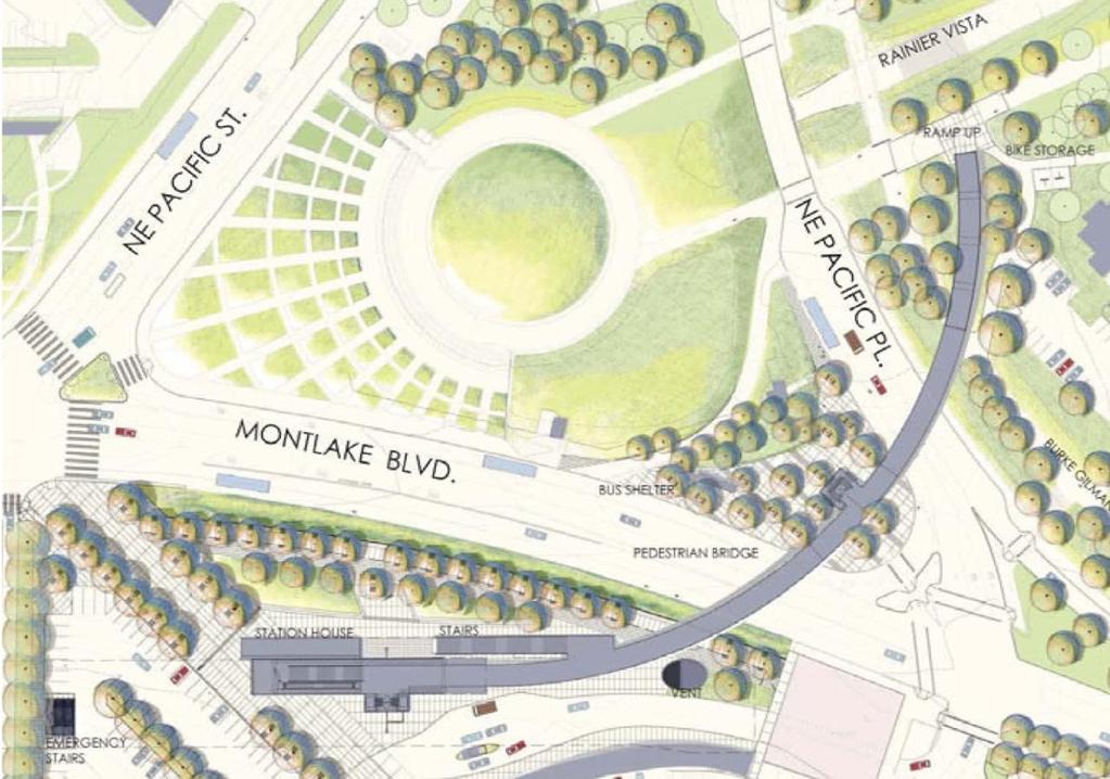
10 Existing Rainier Vista & Montlake Triangle Proposed Design w/ Sound Transit Bridge

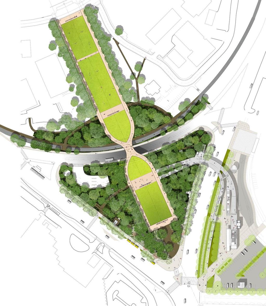
11 1. Rainier Vista 2. Land Bridge 3. Plaza 4. Pedestrian Bridge 5. Bike/Pedestrian Ramp 6. UW Station (Sound Transit) Proposed Design

12 New Sound Transit Bridge Landing on Rainier Vista, Looking West

13 Rainier Vista from New Pedestrian Bridge Landing Plaza on Triangle

14 Rainier Vista View North to Drumheller Fountain from Triangle

15 Approaching UW Station & Husky Stadium from South on Montlake

16 Husky Stadium Approach from Sound Transit UW Station

17 Approaching UW Station & Husky Stadium from South on Montlake

18 Approaching UW Station & Husky Stadium from North on Montlake
19 Project Execution Plan Three Subprojects SP1 Montlake Pedestrian Bridge Design & Construction by Sound Transit Budget $11.4 million Construction SP2 Rainier Vista Land Bridge Design & Construction by UW Budget $20.8 million Construction 2014
20 Project Execution Plan Three Subprojects SP3 Rainier Vista Hardscape and Landscape Design & Construction by UW Budget $4.5 million Construction 2015 ST to provide Accounting and Project Control 3 Party Executive Committee (WSDOT, ST, UW)
21 Budget Costs through 30% Design $ 1.3 million SP1 (30%) $11.4 million SP2 (55%) $20.8 million SP3 (12%) $ 4.5 million Total Project Cost $38.0 million
22 Funding Plan UW (10.5%)* $ 4 million ST (31.6%)* $12 million WSDOT (57.9%)* $22 million Sub Total Project Funding $38 million WSDOT Construction Reserve $ 5 million Total Project Funding* $43 million *Funding over $43 million, if required, will be shared in these percentages
23 Agreements November 2010 Term Sheet Three Party MOA Five Party Agreement
24 Three Party MOA The Three Party MOA outlines the following: Roles and responsibilities of each agency for funding and construction of the SP1, SP 2 and SP3 Funding commitment by each agency Process for requesting use of $5 million reserve Process for monitoring progress and reconciliation of expenses Process for approval of work, design review, final inspection, ownership and maintenance of project elements Termination clause
25 Five Party Agreement The five party agreement is between UW, ST, WSDOT, Metro and SDOT. It outlines the work and coordination to be done between these five agencies to assure project moves forward on schedule and within budget Metro and SDOT are not funding partners but they are critical to the success of the project through approval of permits and relocation of bus stops during construction
26 Risks No termination after start of first construction Majority of budget is committed in 2014 Unknown Conditions in Triangle Garage Unknown Conditions lowering Pacific Place Federal Contracting Requirements
UNIVERSITY OF WASHINGTON TO SOUND TRANSIT U-LINK PEDESTRIAN CONNECTION PROJECT EIS ADDENDUM
 UNIVERSITY OF WASHINGTON TO SOUND TRANSIT U-LINK PEDESTRIAN CONNECTION PROJECT EIS ADDENDUM UNIVERSITY OF WASHINGTON SOUND TRANSIT January 2011 EIS Addendum for the University of Washington to Sound Transit
CITY OF SEATTLE RESOLUTION. WHEREAS, the Washington State Department of Transportation (WSDOT) led the Seattle
 led the Seattle") SDOT SR0 Design Refinements RES August, 0 Version #D 0 CITY OF SEATTLE RESOLUTION..title A RESOLUTION relating to the State Route 0, Interstate to Medina Bridge Replacement and High Occupancy Vehicle Project;
SDOT SR0 Design Refinements RES August, 0 Version #D 0 CITY OF SEATTLE RESOLUTION..title A RESOLUTION relating to the State Route 0, Interstate to Medina Bridge Replacement and High Occupancy Vehicle Project;
Dear Mayor Murray, Top SR-520 Design Innovations and Remaining Opportunities
 Dear Mayor Murray, Thank you for your leadership building a transportation system that moves people efficiently throughout the region, and creates healthy places to live, work, and play. We are glad you
MOTION NO. M Contract Amendment for Systems Construction Management Consultant Services
 MOTION NO. M2017-74 Contract Amendment for Systems Construction Management Consultant Services MEETING: DATE: TYPE OF ACTION: STAFF CONTACT: Capital Committee PROPOSED ACTION 5/11/2017 5/25/2017 Recommend
TRANSPORTATION MANAGEMENT PLAN MAY 2018 DRAFT
 TRANSPORTATION MANAGEMENT PLAN MAY 2018 DRAFT TABLE OF CONTENTS Introduction... 1 History/Context... 4 Performance Goals... 6 TMP Framework... 7 Transit... 8 Pedestrian...10 Bicycle...12 General Purpose
Design of Stanley Park S-Curve
 ADMINISTRATIVE REPORT Date: May 4, 2001 TO: FROM: Author/Local: F. Klotzbach/7118 RTS NO. 01644 CC File No. Standing Committee on Transportation and Traffic General Manager of Engineering Services, in
Basalt Creek Transportation Refinement Plan Recommendations
 Basalt Creek Transportation Refinement Plan Recommendations Introduction The Basalt Creek transportation planning effort analyzed future transportation conditions and evaluated alternative strategies for
C C C
 C-012-001 Thank you for your support for the creation of new public space and nonmotorized access between downtown and the waterfront through the Overlook Walk, the East-West Connections, and the Promenade.
Capital Projects Update: N. Lynn Street Esplanade and Custis Trail Improvements 100% Engineering Design - Progress Report
 Capital Projects Update: N. Lynn Street Esplanade and Custis Trail Improvements 100% Engineering Design - Progress Report UPC 70762 Locally Administered PE Phase VDOT Administered CN Phase 4/6/17 1 Project
Existing Transportation System
 < Open for Additional Text Transportation System Existing Transportation System This section describes vehicular transportation associated with Children s. transportation are described in a separate section
Capital Projects Update: N. Lynn Street Esplanade and Custis Trail Improvements Advertisement for Construction - Progress Report
 Capital Projects Update: N. Lynn Street Esplanade and Custis Trail Improvements Advertisement for Construction - Progress Report UPC Design 70762 / CN 109813 Locally Administered PE Phase VDOT Administered
Chapter 4: Funding and Implementation
 Chapter 4: Funding and Implementation 83 84 Cost Estimating Cost estimating is an iterative process. When a project is in the conceptual stage, preliminary cost estimates are also provided conceptually,
Chapter 7 Nonmotorized Facilities
 Chapter 7 Nonmotorized Facilities What is in this chapter? This chapter discusses existing and proposed pedestrian and bicycle facilities referred to as nonmotorized facilities along the SR 520 corridor.
TRANSPORTATION TRAINING TOPICS. April 6, 2010
 TRANSPORTATION TRAINING TOPICS April 6, 2010 Roles of Transportation Providers Context and Policy Makers Division of Transportation and Traffic Other City Operations Other Transportation Operators CMA
Operations -- Transit From: N/A To: N/A. Improvement Type: Regionally Significant: No
 Central Puget Sound Regional 2017-2020 Transportation Improvement Program Amendments and Corrections to be included in the 2017-20 STIP PSRC's Amendment 2017-08 County: King List of 17-08 Amendment Projects:
AMATS Complete Streets Policy
 AMATS Complete Streets Policy Table of Contents: Section 1. Definition of Complete Streets Section 2. Principles of Complete Streets Section 3. Complete Streets Policy Section 4. Consistency Section 5.
01. VICINITY OF GREENBRAE POC: EXISTING CONDITIONS
 01. VICINITY OF GREENBRAE POC: EXISTING CONDITIONS Existing Bus Stop Existing US101 On-ramp Existing POC Old Redwood Highway Rich Street City ROW Environmental Study Limit Industrial Way NO DESIGNATED
See Figure 38, Existing Nonmotorized Connections.
 Nonmotorized Connections Existing Nonmotorized Connections Pedestrian, vehicle and bike traffic access and movements are confined primarily to Penny Drive on campus. Due to the steep slope along the length
SPRINGFIELD REVITALIZATION REPORT
 SPRINGFIELD REVITALIZATION REPORT August 2015 Homewood Suites Springfield Town Center Promenade 2 SPRINGFIELD OVERVIEW This report covers recent development activity in the Springfield Commercial Revitalization
Welcome to the Sellwood Bridge Project Open House!
 Welcome to the Sellwood Bridge Project Open House! 5:30 7:30 pm Please sign in here Information stations and project staff are located throughout the room. Goals for Tonight s Meeting: Learn how the Preferred
ACTION TRANSMITTAL No
 Transportation Advisory Board of the Metropolitan Council of the Twin Cities DATE: August 25, 2016 TO: FROM: ACTION TRANSMITTAL No. 2016-47 Technical Advisory Committee TAC Funding and Programming Committee
UNIVERSITY OF WASHINGTON burke-gilman trail CORRIDOR STUDY
 UNIVERSITY OF WASHINGTON burke-gilman trail CORRIDOR STUDY July 2011 \\fpse2\data2\2010projects\se10-0209_bu UNIVERSITY OF WASHINGTON BURKE-GILMAN TRAIL CORRIDOR STUDY TABLE OF CONTENTS i TABLE OF CONTENTS
Oakland Pedestrian Master Plan Oakland Pedestrian Plan Draft Recommendations Chapter Outline
 EISEN LETUNIC T R A N S P O R T A T I O N, ENVIRO N M E N TA L A N D URBAN PLANNIN G MEMORANDUM To Oakland Pedestrian Plan Technical Advisory Committee & Pedestrian Advisory Group From Victoria Eisen Date
HOOPA DESIGN FAIR 4. IMPLEMENTATION PHASES & FUNDING
 4. IMPLEMENTATION PHASES & FUNDING HOOPA DESIGN FAIR 4-1 4. IMPLEMENTATION PHASES & FUNDING Phase One Development 1. Implementation The Conceptual Plan recommends five concept elements to revitalize downtown
Beyond the Highway. Tale of the Trails. Tom Beekman, P.E. Northwest Regional Planning Chief Department of Transportation
 Beyond the Highway Tale of the Trails Tom Beekman, P.E. Northwest Regional Planning Chief Department of Transportation Beyond the Highway October 11, 2016 Stevens Point, WI Wisconsin DOT and Trails TOPICS
CURRENT AND VOTER APPROVED SOUND TRANSIT SERVICE
 CURRENT AND VOTER AROVED SOUND TRANSIT SERVICE Everett MA KEY Link Light Rail Mukilteo Link (SeaTac/Airport University of Washington) Tacoma Link (Tacoma Dome Theater District) Under Construction In Design
Americans with Disabilities Act Transition Plan for Public Right-of-Way Improvements
 Americans with Disabilities Act Transition Plan for Public Right-of-Way Improvements Prepared by: Public Works Department Engineering Division October 2015 Table of Contents Section I Introduction.. 3
Golden s Plan. For the Highway 6 & 93 Corridor
 Golden s Plan For the Highway 6 & 93 Corridor Purpose of the Study Accommodate regional traffic needs on Highways 6 and 93, as defined by the Northwest Quadrant Feasibility Study. Find a solution that
US 19 Pedestrian and Bicycle Safe Access to Transit Corridor Study
 US 19 Pedestrian and Bicycle Safe Access to Transit Corridor Study DRAFT Technical Memorandum #6 Cost and Benefit Evaluation Methodology August 2016 Prepared for: FLORIDA DEPARTMENT OF TRANSPORTATION DISTRICT
Measure A Pedestrian & Bicycle Program Update. April 4, 2019 Board of Directors Agenda Item #10 (b)
") Measure A Pedestrian & Bicycle Program Update April 4, 2019 Board of Directors Agenda Item #10 (b) Overview Program background Program allocations & delivery status Feature Project: California Drive Roundabout
Measure A Pedestrian & Bicycle Program Update April 4, 2019 Board of Directors Agenda Item #10 (b) Overview Program background Program allocations & delivery status Feature Project: California Drive Roundabout
CITY OF KASSON TRANSPORTATION ALTERNATIVES KASSON SAFE ROUTES TO SCHOOL
 ve ha 8t G B A Mantorville Ave N 240th Ave 16th St NE 11th Ave NE K-M HIGH SCHOOL SUNRISE TRAIL TO MANTORVILLE MNTH 57 SUNSET TRAIL TO MANTORVILLE NE PARK 16TH ST NE TRAIL K-M ELEMENTARY SCHOOL K-M MIDDLE
South King County High Capacity Transit Corridor Report. Regional Transit Connections and Active Transportation
 Regional Transit Connections and Active Transportation South King County High Capacity Transit Corridor Report Alternative B2 connects to the dense bus network in West Seattle as a result of reaching the
PEDESTRIAN ACTION PLAN
 ATTACHMENT 2 CITY OF SANTA MONICA PEDESTRIAN ACTION PLAN CITY OF SANTA MONICA PEDESTRIAN ACTION PLAN This page intentionally left blank EXECUTIVE SUMMARY CHAPTER 1 EXECUTIVE SUMMARY Setting the Stage
ACTIA Programs Annual Compliance Report Reporting Year Bicycle and Pedestrian Safety Table 1: Summary of Expenditures and Accomplishments
 Bicycle and Pedestrian Safety Table 1: Summary of Expenditures and Accomplishments Note: Definitions for each drop down menu appear as Comments (scroll over the column title or in the Review mode, choose
12 RECOMMENDATIONS Road Improvements. Short Term (generally the next five years)
") 12 RECOMMENDATIONS Recommendations are based on the technical analysis of existing and future road and active transportation conditions, the results of the review of existing City policies and public feedback.
12 RECOMMENDATIONS Recommendations are based on the technical analysis of existing and future road and active transportation conditions, the results of the review of existing City policies and public feedback.
Sony Centre for Performing Arts
 CAPITAL PROGRAM SUMMARY Highlights Overview I: 10-Year Capital 6 II: Issues for Discussion 15 Sony Centre for Performing Arts 2016 2025 CAPITAL BUDGET AND PLAN OVERVIEW The Sony Centre for the Performing
IMPLEMENTATION STRATEGIES
 GEORGETOWN SIDEWALK MASTER PLAN 34% of funding is dedicated to Downtown Overlay District sidewalks 28% of funding is recommended within 1/4 mile of Southwestern University 26% of funding is recommended
SAN FRANCISCO MUNICIPAL TRANSPORTATION AGENCY
 THIS PRINT COVERS CALENDAR ITEM NO. : 11 DIVISION: Sustainable Streets BRIEF DESCRIPTION: SAN FRANCISCO MUNICIPAL TRANSPORTATION AGENCY Approving traffic modifications on Twin Peaks Boulevard between Christmas
Pedestrian & Bicycle Program & Safe Routes to School 2016
 Pedestrian & Bicycle Program & Safe Routes to School 2016 Charlotte Claybrooke, Local Programs Active Transportation Programs Manager Tribal Transportation Conference September 29, 2016 2 WSDOT Local Programs
Circulation in Elk Grove includes: Motor vehicles, including cars and trucks
 Circulation, as it is used in this General Plan, refers to the many ways people and goods move from place to place in Elk Grove and the region. Circulation in Elk Grove includes: Motor vehicles, including
Omaha s Complete Streets Policy
 Omaha s Complete Streets Policy (Adopted August 2015) VISION To create great places and enhance our quality of life, the City of Omaha will provide safe, accessible streets for all users. Complete Streets
Duwamish Way-finding and CTR Report
 V. North Tukwila When the North Tukwila Manufacturing and Industrial Center was designated in 1992 as part of the region s land use and transportation plan, the plan called for the area to set a light-rail
GRTC Bus Rapid Transit: Semi-Final Design Phase Public Meetings: October 26 & 27, 2015
 GRTC Bus Rapid Transit: Semi-Final Design Phase Public Meetings: October 26 & 27, 2015 Welcome! Meeting Agenda Project update presentation Up to 15 minutes for Pulse Q&A about project design. (Please reserve
4. ENVIRONMENTAL IMPACT ANALYSIS 9. TRANSPORTATION AND TRAFFIC
 4. ENVIRONMENTAL IMPACT ANALYSIS 9. TRANSPORTATION AND TRAFFIC 4.9.1 INTRODUCTION The following section addresses the Proposed Project s impact on transportation and traffic based on the Traffic Study
ACTIA Programs Annual Compliance Report Reporting Year Bicycle and Pedestrian Safety Table 1: Summary of Expenditures and Accomplishments
 Bicycle and Pedestrian Safety Table 1: Summary of Expenditures and Accomplishments Note: Definitions for each drop down menu appear as Comments (scroll over the column title or in the Review mode, choose
Section 8. Partnerships and Funding
 This section discusses the potential partnership and funding options that the Town should consider in order to assist with the implementation of the recommendations provided in the Plan. Section 8. Partnerships
Terwillegar Drive Expressway Draft Concept Plan
 Terwillegar Drive Expressway Draft Concept Plan Anthony Henday Drive to Whitemud Drive November 28 5:00-8:00 p.m. December 1 10:00 a.m. - 3:00 p.m. Let s Talk Today you can: Learn about the new direction
APPENDIX G: INTERSECTION NEEDS AT OKEECHOBEE BOULEVARD
 APPENDIX G: INTERSECTION NEEDS AT OKEECHOBEE BOULEVARD INTERSECTION NEEDS AT SR 7 and OKEECHOBEE BOULEVARD SR 7 Extension Project Development and Environment (PD&E) Study From Okeechobee Boulevard (SR
VDOT I-66 Inside the Beltway Eastbound Widening Environmental Assessment. Staff Recommendations
 VDOT I-66 Inside the Beltway Eastbound Widening Environmental Assessment Staff Recommendations Department of Environmental Services Transportation January 28, 2017 Timeline of Transform66 June 2012: I-66
Exhibit 1 PLANNING COMMISSION AGENDA ITEM
 Exhibit 1 PLANNING COMMISSION AGENDA ITEM Project Name: Grand Junction Circulation Plan Grand Junction Complete Streets Policy Applicant: City of Grand Junction Representative: David Thornton Address:
Access Routes from US 101 to the Richmond San Rafael Bridge
 Access Routes from US 101 to the Richmond San Rafael Bridge TAM Board Meeting January 28, 2016 RSRB Project Elements Eastbound Third Lane: Sir Francis Drake Blvd. to Marine Street 10 ft Barrier Separated
Memorandum. Exhibit 60 SSDP To: Jenny Bailey, Senior Planner. From: Bill Schultheiss, P.E. (WA. P.E. #46108) Date: June 20, 2017
 Date: June 20, 2017") Memorandum To: Jenny Bailey, Senior Planner From: Bill Schultheiss, P.E. (WA. P.E. #46108) Date: June 20, 2017 Re: East Lake Sammamish Trail, Segment 2B Review King County has asked Toole Design Group
Memorandum To: Jenny Bailey, Senior Planner From: Bill Schultheiss, P.E. (WA. P.E. #46108) Date: June 20, 2017 Re: East Lake Sammamish Trail, Segment 2B Review King County has asked Toole Design Group
University of Victoria Campus Cycling Plan Terms of Reference. 1.0 Project Description
 University of Victoria Campus Cycling Plan Terms of Reference 1.0 Project Description The Campus Cycling Plan, a first for the University, will provide a comprehensive and coordinated approach to support
Beyond the Highway. Trails and trails. Tom Beekman, P.E. Northwest Regional Planning Chief Department of Transportation
 Beyond the Highway Trails and trails Tom Beekman, P.E. Northwest Regional Planning Chief Department of Transportation Beyond the Highway December 01, 2015 Trego, WI Gary Brunner, P.E. Northwest Regional
East San Fernando Valley Transit Corridor. Draft EIS/EIR Public Hearing (September 1 thru October 16, 2017
 East San Fernando Valley Transit Corridor Draft EIS/EIR Public Hearing (September 1 thru October 16, 2017 1 Public Comments Release of Draft EIS/EIR September 1, 2017 through October 16, 2017 45-day Public
ELEMENT 11 TRANSPORTATION ELEMENT
 ELEMENT 11 TRANSPORTATION ELEMENT TRANSIT, CIRCULATION, PARKING, PEDESTRIAN, & NON-VEHICULAR CIRCULATION Introduction The following narrative describes the concepts on which the transportation plan is
Keep Placer Moving. Placer is Growing. POPULATION (From 2014 to 2045) 70,000 new homes and well over 180,000 more residents
 70,000 new homes and well over 180,000 more residents") Keep Placer Moving Placer is Growing Keep Placer Moving POPULATION (From 2014 to 2045) 70,000 new homes and well over 180,000 more residents 30% of the total housing market growth in the Sacramento region.
Keep Placer Moving Placer is Growing Keep Placer Moving POPULATION (From 2014 to 2045) 70,000 new homes and well over 180,000 more residents 30% of the total housing market growth in the Sacramento region.
Appendix 3 Roadway and Bike/Ped Design Standards
 Appendix 3 Roadway and Bike/Ped Design Standards OTO Transportation Plan 2040 4/20/2017 Page A3-1 Adopted Standards The adopted OTO Design Standards and Major Thoroughfare Plan are contained herein.
Overview. Illinois Bike Summit IDOT Complete Streets Policy Presentation. What is a Complete Street? And why build them? And why build them?
 Overview Illinois Bike Summit IDOT Complete Streets Policy Presentation Aren Kriks, P.E. District One Bicycle Coordinator and Bureau of Programming Project Engineer History of Complete Streets IDOT Policy
APPENDIX A: Complete Streets Checklist DRAFT NOVEMBER 2016
 APPENDIX A: Complete Streets Checklist DRAFT NOVEMBER 2016 Complete Streets Checklist MetroPlan Orlando s Complete Streets Checklist is an internal planning tool for staff to further implementation of
UPC Design / CN Locally Administered PE Phase VDOT Administered CN Phase
 Presentation for County Board, February 27, 2018 Regular Hearing N. Lynn Street Esplanade and Custis Trail Improvements Funding Request for VDOT Construction Bid Award UPC Design 70762 / CN 109813 Locally
ARLINGTON COUNTY, VIRGINIA
 ARLINGTON COUNTY, VIRGINIA County Board Agenda Item Meeting of October 15, 2016 DATE: October 7, 2016 SUBJECT: Adoption of amendments to the Master Transportation Plan (MTP) to create a new Pedestrian
Establishment of Triggers. Second Montlake Bridge Workgroup
 Establishment of Triggers June 2012 Table of Contents Page 1 Executive Summary -- The Condtions and Triggers...1-2 2 Background and History...2-1 3 Assessment of A Bicycle and Pedestrian Trigger...3-1
The Bike Buzz in Richland. November 2017 Carl Berkowitz
 The Bike Buzz in Richland November 2017 Carl Berkowitz Richland has been growing by leaps and bounds with lots of new homes and roads throughout the community. Recognizing all the growth in the Queensgate
Comments EXECUTIVE SUMMARY
 Comments 1. Under any Alternatives, MCDOT should provide better at-grade pedestrian crossing of Georgia Avenue and Forest Glen Road, including improved crosswalks with wider medians and adequate signal
City of Madison: 2017 Capital Budget Capital Improvement Plan
 Capital Improvement Plan Project Summary Bikeways Program 779,000 751,000 630,000 670,000 703,000 703,000 Cannonball Path 210,000 - - 730,000 - - Cap City Trail 1,140,000-360,000 - - 910,000 Ice Age Junction
Mobileye Shield+ Collision Avoidance System Pilot Program
 Information Item Date: August 16, 2017 To: From: Subject: Mayor and City Council Edward F. King, Director of Transit Services Mobileye Shield+ Collision Avoidance System Pilot Program Introduction Big
INDEX. Geometric Design Guide for Canadian Roads INDEX
 Acceleration lane, see Lanes, Acceleration Access, 8.1 Access Management and Functional Classification 8.2 Access Management by Design Classification 8.3 Access Configuration 8.4 Building Set-Back Guidelines
INDOT Complete Streets Guideline & Policy
 INDOT Complete Streets Guideline & Policy INTRODUCTION The Complete Streets guidelines build upon multiple efforts and promote a multimodal transportation system that is integrated and sustains land use
CHAPTER 3. Transportation and Circulation
 CHAPTER 3 Transportation and Circulation 3.0 TRANSPORTATION AND CIRCULATION This chapter evaluates traffic circulation, transit, parking, pedestrian, bicycle, and rail operational conditions in the Project
City of Wilsonville 5 th Street to Kinsman Road Extension Project
 City of Wilsonville 5 th Street to Kinsman Road Walking Tour & Neighborhood Workshop Summary Report Public Outreach Overview On July 18 th, 2017, the City of Wilsonville hosted a neighborhood walking tour
BUDGET FOR RESEDA BOULEVARD, STREET RECONSTRUCTION / VISION ZERO PROGRAM, REPORT BACK, COUNCIL FILE
 FORM GEN. 160 (Rev. 11-02) CITY OF LOS ANGELES INTERDEPARTMENTAL CORRESPONDENCE Date: To: Honorable City Council From: Gary Lee Moore, City Engineer Bureau of Engineering 7%mt /Electronically signed by
Seattle Children's Safety Garden
 Seattle Children's Safety Garden Proposal Submitted to Seattle Parks Opportunity Fund by: Seattle Neighborhood Greenways Project Cost: $1.5 million development cost Proposed Location:Genesee Park in Columbia
Proposed. City of Grand Junction Complete Streets Policy. Exhibit 10
 Proposed City of Grand Junction Complete Streets Policy Exhibit 10 1 City of Grand Junction Complete Streets Policy Vision: The Complete Streets Vision is to develop a safe, efficient, and reliable travel
Existing Transportation System
 < Please Open Page for Additional Text Transportation System Existing Transportation System This section describes vehicular transportation associated with Children s. Pedestrian and other nonmotorized
FUNDING SOURCES CHAPTER 6
 CHAPTER 6 6.1 BICYCLE 6.1.1 Local 6.1.2 Regional 6.1.3 State 6.1.4 Federal 6.1.5 Public Facilities 6.1.6 Bicycle Registration and Licensing Fees 6.1.7 Summary Table 6.1 of Bicycle Funding Sources 6 2 6.2
CITY OF VAUGHAN EXTRACT FROM COUNCIL MEETING MINUTES OF OCTOBER 30, 2012
 CITY OF VAUGHAN EXTRACT FROM COUNCIL MEETING MINUTES OF OCTOBER 30, 2012 Item 31, Report No. 39, of the Committee of the Whole, which was adopted without amendment by the Council of the City of Vaughan
West Dimond Blvd Upgrade Jodhpur Street to Sand Lake Road
 West Dimond Blvd Jodhpur St to Sand Lake CSS Transportation Project Summary Municipality of Anchorage Project # 05 005 Project Manager: John Smith, P.E. (MOA PM&E) Project Administrator: Julie Makela,
Living Streets Policy
 Living Streets Policy Introduction Living streets balance the needs of motorists, bicyclists, pedestrians and transit riders in ways that promote safety and convenience, enhance community identity, create
5. RUNNINGWAY GUIDELINES
 5. RUNNINGWAY GUIDELINES These guidelines should be considered collectively when making runningway decisions. A runningway is the linear component of the transit system that forms the right-of-way reserved
MEASURE B AND MEASURE BB Annual Program Compliance Report Reporting Fiscal Year AGENCY CONTACT INFORMATION
 MEASURE B AND MEASURE BB Annual Program Compliance Report Reporting Fiscal Year 2016-2017 AGENCY CONTACT INFORMATION Agency Name: City of Livermore Date: 12/4/2017 Primary Point of Contact Name: Debbie
San Jose Transportation Policy
 San Jose Transportation Policy Protected Intersections in LOS Policies to Support Smart Growth Presented by: Manuel Pineda City of San Jose Department of Transportation Bay Area Map San Francisco Oakland
Southwest Bus Rapid Transit (SW BRT) Functional Planning Study - Executive Summary January 19 LPT ATTACHMENT 2.
 Functional Planning Study - Executive Summary January 19 LPT ATTACHMENT 2.") Southwest Bus Rapid Transit (SW BRT) Functional Planning Study - Executive Summary 2011 January 19 1 of 19 Introduction This executive summary presents the results of the Southwest Bus Rapid Transit (SW
Southwest Bus Rapid Transit (SW BRT) Functional Planning Study - Executive Summary 2011 January 19 1 of 19 Introduction This executive summary presents the results of the Southwest Bus Rapid Transit (SW
405 Express Lanes General Information & Frequently Asked Questions
 The questions and answers below provide current information on the project to improve Interstate 405 (I-405) in Orange County from State Route 73 to Interstate 605. Why are improvements needed on I-405?
 COMPLETE STREETS CHECKLIST City of Philadelphia The City of Philadelphia's Complete Streets policies are designed ensure that city streets are safe, comfortable and convenient for people of all ages and
NEIGHBORHOOD TRAFFIC CALMING PROGRAM. Policy and Procedure. Roswell Department of Transportation (770)
") NEIGHBORHOOD TRAFFIC CALMING PROGRAM Policy and Procedure Roswell Department of Transportation (770) 594 6420 Approved by M&CC on December 19, 2011 Table of Contents 1. Application and Intent 2. Program
NEIGHBORHOOD TRAFFIC CALMING PROGRAM Policy and Procedure Roswell Department of Transportation (770) 594 6420 Approved by M&CC on December 19, 2011 Table of Contents 1. Application and Intent 2. Program
Chapter 5. Complete Streets and Walkable Communities.
 Chapter 5. Complete Streets and Walkable Communities. 5.1 Description of Complete Streets. Cities throughout the world, and specifically the United States, are coming to embrace a new transportation and
EXHIBIT B-1 PROJECT DESCRIPTION. Phase 1 of the Preferred Alternative
 EXHIBIT B-1 PROJECT DESCRIPTION Phase 1 of the Preferred Alternative The Transform 66 Public-Private Partnership (P3) Project (the Project ) means the Phase 1 of the Preferred Alternative components of
Accommodating Pedestrians in the Work Zone
 Accommodating Pedestrians in the Work Zone Guidance for Section C Plan Preparers Some impacts cannot be avoided and those impacts apply to residents, businesses, motorists, and pedestrians alike. However,
ACTIVE TRANSPORTATION/NONMOTORIZED TRANSPORTATION
 ACTIVE TRANSPORTATION/NONMOTORIZED TRANSPORTATION BACKGROUND Active transportation, also known as nonmotorized transportation, is increasingly recognized as an important consideration when planning and
City of Santa Monica City Manager s Update at Council February 23, 2016
 NOTE: This document summarizes the staff report provided on 2/23/2016 with an update to the Open Streets Event date inserted on 4/9/2016. For questions, contact communications@smgov.net Metro will announce
UPDATES 11/14/2018: 10/25/2018: CLOSED 10/22/2018: 10/12/2018: 10/05/2018: 09/27/2018:
 Veterans Boulevard (formerly Boundary Road) This two-year construction project will widen and pave all of Veterans Boulevard. In 2017, the first portion of the road from Highway 16A to 44 Avenue was completed.
3.0 PROJECT DESCRIPTION
 The following section of the Draft EIR contains a description of the proposed Elk Grove Boulevard/SR 99 Interchange Modification project, consistent with the requirements of CEQA Guidelines Section 15124.
Capital Beltway HOT Lanes - Frequently Asked Questions
 Capital Beltway HOT Lanes - Frequently Asked Questions December 20, 2007 1. What is the cost of the project? The fixed-price design-build cost is approximately $1.4 billion. 2. Why have the project costs
12/4/2016 VIA . RE: Grocery Outlet Del Paso (DR16-328)
") 12/4/2016 VIA EMAIL Ethan Meltzer, Assistant Planner City of Sacramento Community Development Department 300 Richards Blvd, 3 rd Floor Sacramento, CA 95811 RE: Grocery Outlet Del Paso (DR16-328) Dear Mr.
12/4/2016 VIA EMAIL Ethan Meltzer, Assistant Planner City of Sacramento Community Development Department 300 Richards Blvd, 3 rd Floor Sacramento, CA 95811 RE: Grocery Outlet Del Paso (DR16-328) Dear Mr.
Background Planning Committee STAFF REPORT March 7, 2018 Page 2 of 2 On June 21, 2017, the Authority approved the programming of second cycle One Bay
 Planning Committee STAFF REPORT Meeting Date: March 7, 2018 Subject Summary of Issues Recommendations Financial Implications Options Attachments Approval of Resolution 18-11-G Appropriating Measure J TLC
MnDOT Implementation of Complete Streets Policy. January 2014
 MnDOT Implementation of Complete Streets Policy January 2014 1 Prepared by Minnesota Department of Transportation 395 John Ireland Boulevard Saint Paul, Minnesota 55155-1899 Phone: 651-296-3000 Toll-Free:
Portland International Airport Bicycle and Pedestrian Plan (October 2003) Staff Acknowledgements
 Staff Acknowledgements") Portland International Airport Bicycle and Pedestrian Plan (October 2003) Staff Acknowledgements Scott King, Senior Aviation Planner Jason Gately, Senior Aviation Planner Preston Beck, Associate Planner
Portland International Airport Bicycle and Pedestrian Plan (October 2003) Staff Acknowledgements Scott King, Senior Aviation Planner Jason Gately, Senior Aviation Planner Preston Beck, Associate Planner
Venetia Valley Elementary School. Travel Plan
 Venetia Valley Elementary School Travel Plan TABLE OF CONTENTS 1. PURPOSE... 1 1.1. SR2S PLANNING, IMPLEMENTATION AND MONITORING... 1 1.2. MARIN COUNTY MEASURE A... 1 2. VENETIA VALLEY ELEMENTARY SCHOOL
About the Wilmington Downtown Circulation Study
 About the Wilmington Downtown Circulation Study Part of the Wilmington i Initiatives partnership Wilmington Area Planning Council City of Wilmington Delaware Department of Transportation Delaware Transit