Working Group 1 Waterway Infrastructure & Management
|
|
|
- Clarence Wilcox
- 5 years ago
- Views:
Transcription
1 Working Group 1 Waterway Infrastructure & Management Bucharest, 27 October 2011 Romeo Soare AFDJ River Administration of the Lower Danube
2 River Administration of the Lower Danube autonomous state control and is the waterways authority for the Romanian sector of Danube; provisions of the Governmental Decision No. 492/2003; main object of activity to assurance the navigation conditions on the Romanian Danube sector.


3 Main activity The topo-hydrographic surveys include data collection, systematisation and processing for the monitoring of the evolution of the hydrological situation on the Danube. providing the data for the realization of the geomorphological model of the Danube bed


4 The result of survey with multibeam is more complex and is more easy to determine the bathymetric line witch is the base for fairway determination


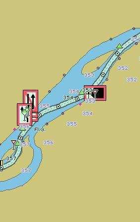
5 Main activity - signalisation the signalling activity consists in installing the necessary costal and floating signs. - monitoring the buoys and lighthouses: Sulina: 39 buoys and 23 lighthouses Galati: 22 buoys and 34 lighthouses Calarasi: 14 lighthouses Giurgiu: 27 lighthouses Tr. Severin: 21 lighthouses


6 CoDeSy,MKII,CMS System represents a monitoring and control instrument of the process devices for navigation such as: lighthouses and buoys, retransmission relays Program permits the visualization, archiving and analysis of the process values of the navigation aids.the access to the process values of the navigation aids is given by VHF, UHF or communication modems via satellite
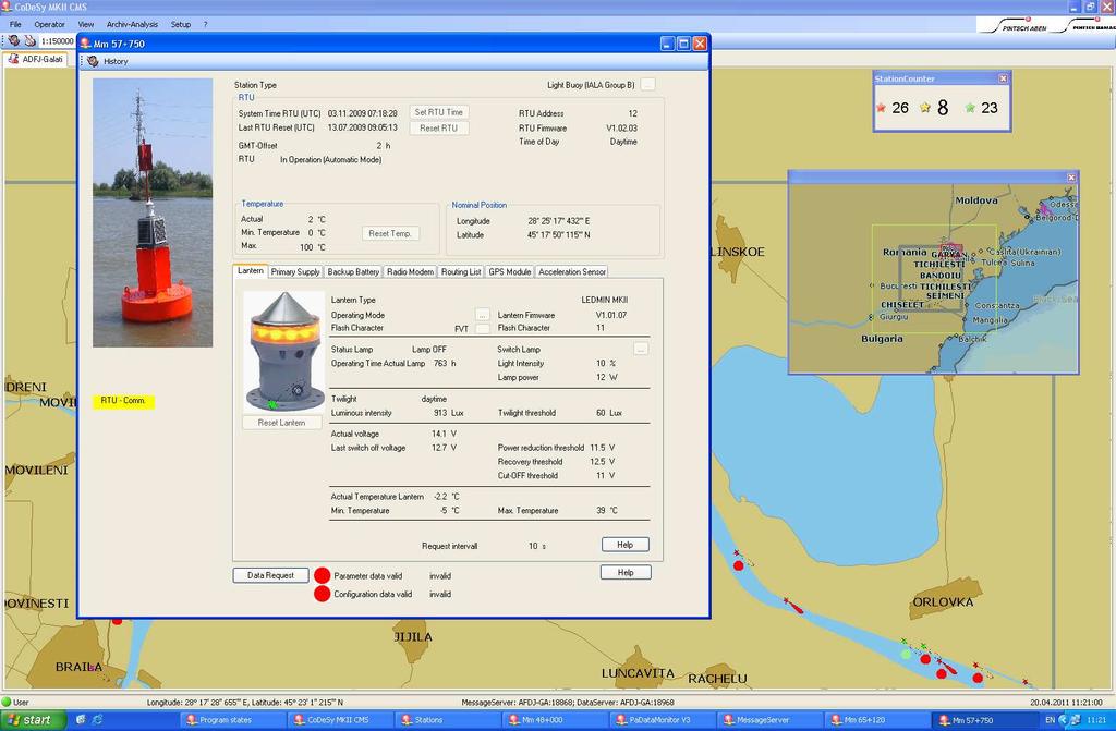
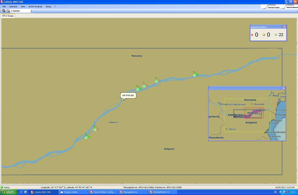
7 Territorial Servers and The Central

8 The dredging activity - assures the required depths for the safe navigation of the ships on the navigable fairway of the Danube.
9 water levels Minimum dephs Poziţie km Punct critic Port referință Cota apei Data Sondajului Lățimea şenalului (m) Adâncimi efective sondate (m)* EV IV C IR ER 824 Salcia Cetate Bogdanu Calafat Pietrişu Calafat Linovo Rast Păpădia Bechet Băloiu Corabia Turcescu Călăraşi Caragheorghe Călăraşi Lebăda Călăraşi Mârleanu Cernavodă Fermecatu Amonte Cernavodă Fermecatu Aval Cernavodă Cernavodă Aval Cernavodă Seimeni Cernavodă Albăneşti (Hârşova+Cvodă)/ Hârşova Aval Hârşova Giurgeni Vadu Oii Hârşova
10
11 TECHNICAL ASSISTANCE FOR THE IMPROVEMENT OF THE NAVIGATION CONDITIONS ON THE DANUBE ISPA 1 -Improvement of the navigation conditions on the Danube between Calarasi and Braila, and accompanying measures ISPA 2 -Technical Assistance for the improvement of navigation conditions on the Romanian-Bulgarian common sector and accompanying studies


12 -ISPA 1 The proposed works will balance the flow distribution which will increase to 40% the flow going on the Old Danube branch, close to the natural distribution on high water levels situation, with negligible influences on flood situations.

13 -ISPA 2 The project is part of the more global Danube navigability project to improve the Pan European Corridor no. VII, which aims to improve the navigability of the Danube River to answer to the needs of the national transport policy of Romania as well as the countries international commitments.


14 -Topo-bathymetry measurements Numerical model - Hydrological and sedimentological additional studies
 ENR-2.5m and foresee an over-depth of 0.")
15 Scenarios Training Works Scenario (TWS) ENR-2.5m and foresee an over-depth of 0.50m Traditional engineering measures Minimum Scenario (MS) ENR-2.5m and no over-depth of 0.50m Minimum engineering measures Enhanced Engineering Scenario (EES) ENR-2.5m and foresee an over-depth of 0.50m Alternative engineering measures Green Engineering Scenario (GES) Measures will be designed as a complex set of measures, locally increasing the natural value of the site and improving the navigability

16 Projects NEWADA, In December 2010, D4D has uploaded IENC`s on the whole Romanian Danube sector. FIS portal WLAN in Iron Gates 1
17 IRIS Europe II Pilot implementation of selected Fairway Information Services (FIS) Actual depth data provision to fairway users Provision of water level information based on water level models to fairway users Enhanced Notices to Skippers Wireless RIS Services for fairway users based upon wireless broadband tech Pilot implementation Traffic and Transport related RIS Services Standardisation Enhancement the AIS infrastructures (on shore, on board) Romania: already installed 250 Inland AIS transponders (mobile), 20 Inland AIS transponders (portable);- 100 ECDIS viewers ;
18 Thank you for your kind attention! Romeo Soare, dipl. eng. Administratia Fluviala a Dunarii de Jos Galati Giurgiu, Stefan cel Mare, no 4, Phone ; Fax , romeo_soare@yahoo.com;
Status of the Fairway Rehabilitation and Maintenance Master Plan for the Danube and its navigable tributaries (dated )
") Status of the Fairway Rehabilitation and Maintenance Master Plan for the Danube and its navigable tributaries (dated 23-11-2018) Key achievements since the endorsement of the Master Plan in 2014 The Fairway
Status of the Fairway Rehabilitation and Maintenance Master Plan for the Danube and its navigable tributaries (dated 23-11-2018) Key achievements since the endorsement of the Master Plan in 2014 The Fairway
Table of. contents. Photos: viadonau, NEWADA duo, Haslinger, Zinner Layout: viadonau
 COMMON DANUBE REPORT 2015 Imprint NEWADA duo project consortium Network of Danube Waterway Administrations data and user orientation Information about the project consortium can be found on pp. 26-27 Photos:
Inland AIS in the Netherlands
 Inland AIS in the Netherlands State of the art traffic manager Peter Stuurman nautical November 13th 2008 Contents Traffic Management in the Netherlands What is agreed en decided in the Netherlands Inland
Waterway management projects co-funded by CEF Programme rkm Danube section in Hungary -
 Waterway management projects co-funded by CEF Programme - 1811-1433 rkm Danube section in Hungary - PÁL KÖTÉL, KÁROLY GOMBÁS MSc in water engineering Fluvial flod protection, deputy department leader NORTH-TRANSDANUBIAN
Monitoring system on implementation of waterway maintenance declaration & short-term measures
 Monitoring system on implementation of waterway maintenance declaration & short-term measures Linz, 16 April 2013 Thomas Hartl Joint Technical Secretariat PAC 1a Slide No. 2 Status: April 2013 Slide No.
Paper for Consideration by HSSC8 Development of an Additional Bathymetry Layer standard based on S-57/S-52
 Paper for Consideration by HSSC8 Development of an Additional Bathymetry Layer standard based on S-57/S-52 Submitted by: CIRM, Germany, USA (NOAA) Executive Summary: Proposal for the standardization of
COMMON DANUBE REPORT 2016
 COMMON DANUBE REPORT 2016 Imprint Danube STREAM consortium Photos: viadonau, Haslinger, Zinner Layout: viadonau Table of contents Scope of document...7 Highlights...8 Sharing a common vision...9 Volume
Centre Albert Borschette, 36 Rue Froissart - Room CCAB-0B, 1040 Brussels
 MINUTES 2nd Advisory Committee Meeting Date 13.12.2016 Time 14:00 17:00 Place Participants For the minutes Centre Albert Borschette, 36 Rue Froissart - Room CCAB-0B, 1040 Brussels See list of participants
THE INFLUENCE OF HYDROTECHNICAL STRUCTURES ON THE MINOR RIVERBED MORPHOLOGY OF THE DANUBE, IN THE BALA BRANCH - OLD DANUBE BIFURCATION AREA
 THE INFLUENCE OF HYDROTECHNICAL STRUCTURES ON THE MINOR RIVERBED MORPHOLOGY OF THE DANUBE, IN THE BALA BRANCH - OLD DANUBE BIFURCATION AREA Alina-Florina Nicolae 1, Puiu Lucian Georgescu 2, Constantin
FAIRway Danube. a milestone for the realization of the Masterplan of the Danube and its navigable tributaries , Katja Rosner / viadonau
 FAIRway Danube a milestone for the realization of the Masterplan of the Danube and its navigable tributaries 15.11.2016, Katja Rosner / viadonau Agenda FAIRway Danube in a nutshell Developments in selected
Integrated Waterway Management of the Danube in Austria
 Integrated Waterway Management of the Danube in Austria Thomas Hartl / Senior Expert Waterway Management via donau Österreichische Wasserstraßen-Gesellschaft mbh Vienna, October 14, 2014 Page 3 Figures
SPEECH. by Deputy Director-General of the Danube Commission s Secretariat. Mr. Pjotr Suvorov. (Linz, April 2013)
") SPEECH by Deputy Director-General of the Danube Commission s Secretariat Mr. Pjotr Suvorov on the 5 th Meeting of the Steering Group for Priority Area 1a of the EUSDR (Linz, 17-18 April 2013) At the 3
SPEECH by Deputy Director-General of the Danube Commission s Secretariat Mr. Pjotr Suvorov on the 5 th Meeting of the Steering Group for Priority Area 1a of the EUSDR (Linz, 17-18 April 2013) At the 3
Status quo of FAIRway Danube
 Status quo of FAIRway Danube Review of Activities since 1.7.2015 13.12.2016, Gert-Jan Muilerman / viadonau Agenda Rehabilitation and Maintenance Masterplan of the Danube and its navigable tributaries Status
Conclusions. on effective waterway infrastructure rehabilitation and maintenance on the Danube and its navigable tributaries. Danube Ministers Meeting
 Conclusions on effective waterway infrastructure rehabilitation and maintenance on the Danube and its navigable tributaries Danube Ministers Meeting Rotterdam 20 th June 2016 We, the Ministers and Heads
Fairway Rehabilitation and Maintenance Master Plan for the Danube and its Navigable Tributaries
 Fairway Rehabilitation and Maintenance Master Plan for the Danube and its Navigable Tributaries PA1a Working Group Session, Vukovar, 28 October 2014 Gudrun Maierbrugger, Technical Secretariat Priority
STATUS QUO REPORT FOR WATERWAY MAINTENANCE IN SERBIA
 NETWORK OF DANUBE WATERWAY ADMINISTRATIONS South-East European Transnational Cooperation Programme STATUS QUO REPORT FOR WATERWAY MAINTENANCE IN SERBIA Document ID: Activity: WP 4 - Improve physical accessibility
EBA Position Statement AIS Virtual Aids to Navigation
 EBA Position Statement AIS Virtual Aids to Navigation Document date: 17 October 2015 Latest update: 9 December 2015 Executive Summary The European Boating Association 1 (EBA) recognises the value of Automatic
Crowdsourced Bathymetry Data via Electronic Charting Systems
 Crowdsourced Bathymetry Data via Electronic Charting Systems Evan Robertson evan.robertson@noaa.gov Cooperative Institute for Research in Environmental Sciences (CIRES), University of Colorado, Boulder,
15 th Meeting of the Steering Group for Priority Area 1a of the EUSDR Vienna, Austria 09 October 2018
 EU Strategy for the Danube Region Priority Area 1a To improve mobility and multimodality: Inland waterways 15 th Meeting of the Steering Group for Priority Area 1a of the EUSDR Vienna, Austria 09 October
Hydrographic Surveying Methods, Applications and Uses
 Definition: Hydrographic Surveying Methods, Applications and Uses It is the branch of surveying which deals with any body of still or running water such as a lake, harbor, stream or river. Hydrographic
National Sturgeon Management Plan
 National Sturgeon Management Plan (To implement the Regional Strategy for the conservation sustainable management of sturgeon populations in the NW Black Sea Lower according to CITES) (v. 03 of 04/25/2006)
The Evolution of an Autonomous Unmanned Surface Vessel and Software for Hydrographic Survey
 The Evolution of an Autonomous Unmanned Surface Vessel and Software for Hydrographic Survey Paul Donaldson In 2017, Leidos, Inc. participated in both the Gulf of Mexico Unmanned Systems Operational Demonstration
Outcome of the discussion with other HSSC WG on contribution to the MSP MSP development work
 NIPWG 4-43.1 Submitted by: Executive Summary: Paper for Consideration by NIPWG IMO e-navigation Hydrographic Services Related Documents: HSSC7 (action item 7/35) Related Projects: IMO e-navigation NIPWG
7th meeting of Steering Group Priority Area 1a of the Danube Region Strategy on Inland Waterways
 7th meeting of Steering Group Priority Area 1a of the Danube Region Strategy on Inland Waterways Vienna 9 May 014 7th Steering Group meeting Priority Area 1a of the EUSDR Vienna, 9 May 014 Reinhard Vorderwinkler
Hydrodynamic and hydrological modelling to support the operation and design of sea ports
 Hydrodynamic and hydrological modelling to support the operation and design of sea ports Data needs and examples Martijn de Jong (port/nautical requirements, waves, currents) Sofia Caires (mean and extreme
Paper Environmental friendly solutions to improve the navigation fairway of the Danube in Serbia
 Paper 166 - Environmental friendly solutions to improve the navigation fairway of the Danube in Serbia ZUIJDERWIJK Michel, MUSKATIROVIC Jasna, MITROVIC Ivan, TJERRY Soren, ZANETTI Roberto Witteveen+Bos,
FEASIBILITY STUDY FOR A WATERWAY MAINTENANCE MANAGEMENT SYSTEM (WMMS) FOR THE DANUBE
 FOR THE DANUBE") NETWORK OF DANUBE WATERWAY ADMINISTRATIONS data & user orientation SOUTH EAST EUROPE TRANSNATIONAL COOPERATION PROGRAMME FEASIBILITY STUDY FOR A WATERWAY MAINTENANCE MANAGEMENT SYSTEM (WMMS) FOR THE DANUBE
NETWORK OF DANUBE WATERWAY ADMINISTRATIONS data & user orientation SOUTH EAST EUROPE TRANSNATIONAL COOPERATION PROGRAMME FEASIBILITY STUDY FOR A WATERWAY MAINTENANCE MANAGEMENT SYSTEM (WMMS) FOR THE DANUBE
Good Navigation Status
 Good Navigation Status Regional GNS workshop Strasbourg, 16 th September 2016 Agenda for today 9:00 Welcome and introduction 9:10 Session 1: Presentation of Good Navigation Status study Questions & answers
Implementation of CEVNI Rev 5. Reinhard Vorderwinkler Austria
 Implementation of CEVNI Rev 5 Reinhard Vorderwinkler Austria SC.3 and SC.3/WP.3 History ITC 1956 sub-committee (SC) on IWT for preparation of international conventions in IWT renamed: principal working
Vessel Traffic Service. Functions and responsibilities. Speaker - Ivan Gotovchitc Head of RVTS
 Vessel Traffic Service. Functions and responsibilities. Speaker - Ivan Gotovchitc Head of RVTS In accordance with the requirements of the International Convention for the Safety of SOLAS-74/88 life at
SIGNI Signs and Signals on Inland Waterways
 ECONOMIC COMMISSION FOR EUROPE INLAND TRANSPORT COMMITTEE Working Party on Inland Water Transport SIGNI Signs and Signals on Inland Waterways Revision 1 Amendment UNITED NATIONS New York and Geneva, 2010
World Championship for ship models Section С
 WORLD ORGANISATION FOR SHIPMODELSPORT NAVIGA ROMANIAN SHIPMODELSPORT FEDERATION "DUNAREA DE JOS" UNIVERSITY OF GALATI SPORT CLUB UNIVERSITATEA GALATI World Championship for ship models Section С Galati,
Paper for consideration by ENC Working Group. Use of AU6 ENC cells as an option for Bathymetric ENCs (benc)
") Paper for consideration by ENC Working Group Use of AU6 ENC cells as an option for Bathymetric ENCs (benc) Submitted by: Alvaro Sanchez (AHS) Executive Summary: Compilation of high density bathymetric
Paper for consideration by ENC Working Group Use of AU6 ENC cells as an option for Bathymetric ENCs (benc) Submitted by: Alvaro Sanchez (AHS) Executive Summary: Compilation of high density bathymetric
Study of river training measures to overcome inland navigation constraints due to future climate changes
 S. Wurms, P.M. Schroeder www.baw.de Outline Background and project aim The research programme KLIWAS Hydraulic bottlenecks under changing hydrological conditions River training options for adaptation to
Simulator an Instrument for Schooling?
 Simulator an Instrument for Schooling? Dipl.-Ing. Klaus Paulus & Dipl.-Ing. Manfred Wieck - Members of EDINNA [Education in Inland Navigation] - 1 Central Commission for the Navigation of the Rhine 30th
Offshore Wind Energy Stringent quality assurance and quality control. Coastal and Freshwater Fast responding and flexible organisation
 Services Oceanographic and Positioning Equipment Rental Meteorological and Oceanographic Surveys Data Analysis and Characterisation Marine Energy Resource Assessment Real-Time Monitoring Founded in 2010,
Economic and Social Council
 United Nations Economic and Social Council Distr.: General 4 August 2010 Original: English Economic Commission for Europe Inland Transport Committee Working Party on Inland Water Transport Fifty-fourth
ROMANIA REPORT ON THE IMPLEMENTATION OF THE AGREEMENT ON CETACEANS OF THE BLAC K AND MEDITERRANEAN SEAS AND CONTIGUOUS ATLANTIC AREA (ACCOBAMS)
") ROMANIA REPORT ON THE IMPLEMENTATION OF THE AGREEMENT ON CETACEANS OF THE BLAC K AND MEDITERRANEAN SEAS AND CONTIGUOUS ATLANTIC AREA (ACCOBAMS) Designated CMS Authority: Ministry of Environment and Forests
ROMANIA REPORT ON THE IMPLEMENTATION OF THE AGREEMENT ON CETACEANS OF THE BLAC K AND MEDITERRANEAN SEAS AND CONTIGUOUS ATLANTIC AREA (ACCOBAMS) Designated CMS Authority: Ministry of Environment and Forests
TRAFFIC MANAGEMENT, RELIABILITY AND ECONOMIC TRANSPORT ON THE INLAND WATERWAY DANUBE by
 TRAFFIC MANAGEMENT, RELIABILITY AND ECONOMIC TRANSPORT ON THE INLAND WATERWAY DANUBE by Markus Hoffmann 1, Alexander Haberl 1, Thomas Hartl 2, Christoph Konzel 2 and Markus Simoner 2 ABSTRACT The analysis
Plot the Path. Mary Anne Otten. lesson three
 Plot the Path Mary Anne Otten lesson three Subject/Grade: Grade 2, Math, Social Studies, Science Duration: one class period Materials needed: Per class: Day the Great Lakes Drained Away by Charles Ferguson
CHARACTERISTICS OF THE ENVIRONMENTAL MATRIX IN THE ROMANIAN BLACK SEA AREA
 THE ANNALS OF DUNAREA DE JOS UNIVERSITY OF GALATI FASCICLE XI SHIPBUILDING. ISSN 1221-4620 2015 CHARACTERISTICS OF THE ENVIRONMENTAL MATRIX IN THE ROMANIAN BLACK SEA AREA Carmen Gasparotti Dunarea de Jos
Delaware River Vessel Reporting System Mariners Advisory Committee For
 Delaware River Vessel Reporting System Mariners Advisory Committee For the Bay and River Delaware The Mariner's Advisory Committee is comprised of Master Mariners, River Pilots, and concerns itself with
THE CHALLENGES OF A LARGE-AREA BATHYMETRIC SURVEY
 THE CHALLENGES OF A LARGE-AREA BATHYMETRIC SURVEY Agenda: - Introduction - Tender - Project Planning - Survey - Processing - Delivery - Conclusion 2 Introduction We know less of the oceans at our feet,
A Government Service to State Owned Enterprise.
 Re-organization of Hydrographic Survey Operations in Finland A Government Service to State Owned Enterprise Kari Pohjola Hydro 2010, Rostock-Warnemuende, Germany, 02-05 November 2010 Re-organization of
Plot the Path into the Harbor
 Plot the Path into the Harbor By Mary Anne Otten, Rudyard Area Schools and Joan Chadde, Michigan Technological University Subject/Grade: Grade 3 6, Math, Social Studies, Science Duration: 35 minutes Lesson
TIME VARYING OBJECTS IN ECDIS Today, tomorrow and soon after
 TIME VARYING OBJECTS IN ECDIS Today, tomorrow and soon after by Bohdan PILLICH 1 Abstract ECDIS is about to become a commercial reality. However, the full potential of the system is not likely to be realised
The 11 th International Scientific Conference elearning and Software for Education Bucharest, April 23-24, 2015
 The 11 th International Scientific Conference elearning and Software for Education Bucharest, April 23-24, 2015 10.12753/2066-026X-14-067 SIMULATION TECHNIQUES FOR TRAINING AND COACHING OF NAVY OFFICERS
1 st Tidal and Water Level Working Group Meeting DHN, Niteroi, Brazil 31/03/09 02/04/09 Vertical Offshore Reference Framework (VORF) Chris Jones
 Chris Jones") 1 st Tidal and Water Level Working Group Meeting DHN, Niteroi, Brazil 31/03/09 02/04/09 Vertical Offshore Reference Framework (VORF) Chris Jones United Kingdom Hydrographic Office Presentation Structure
1 st Tidal and Water Level Working Group Meeting DHN, Niteroi, Brazil 31/03/09 02/04/09 Vertical Offshore Reference Framework (VORF) Chris Jones United Kingdom Hydrographic Office Presentation Structure
Another essential characteristic of boat channel geography is the form and spacing of channel
 Another essential characteristic of boat channel geography is the form and spacing of channel segments.some channels are simple, and others are complex. The channel systems include: finger canals or basins;
Admiralty e-navigator
 Admiralty e-navigator Admiralty e-navigator Service e-navigation is the harmonised collection, integration, exchange, presentation and analysis of maritime information onboard and ashore by electronic
AIS Applications in Russian Testbed Area "Hermitage" Evgeny Gayduk Deputy Promotion Director Kronstadt Group Saint-Petersburg, RUSSIA
 AIS Applications in Russian Testbed Area "Hermitage" Evgeny Gayduk Deputy Promotion Director Kronstadt Group Saint-Petersburg, RUSSIA Kronstadt Group 2 1990 Creating Transas company Creating Transas Group
Rule 5 - Look-out. 1
 Every vessel shall at all times maintain a proper look-out by sight and hearing as well as by all available means appropriate in the prevailing circumstances and conditions so as to make a full appraisal
NATIONAL REPORT OF SWEDEN
 54 th NHC Meeting 13-14 April 2010, Reykjavik NATIONAL REPORT OF SWEDEN Executive summary This report gives a summary of the main activities within the Swedish Hydrographic Office since the last report
Norwegian Coastal Administration (NCA) HSSC November 2015 Busan - Republic of Korea
 HSSC November 2015 Busan - Republic of Korea") Norwegian Coastal Administration (NCA) HSSC7 9-13 November 2015 Busan - Republic of Korea Requirements relating to sector lights for Electronic Navigational Chart (ENC) Product Specifications B E Krosness
Norwegian Coastal Administration (NCA) HSSC7 9-13 November 2015 Busan - Republic of Korea Requirements relating to sector lights for Electronic Navigational Chart (ENC) Product Specifications B E Krosness
The Pan-European Masterplan for Cycling Promotion - A framework for starter, climber and champion countries
 The Pan-European Masterplan for Cycling Promotion - A framework for starter, climber and champion countries Birgitta Worringen, Germany Federal Ministry of Transport and Digital Infrastructure Head of
CO 2 reduction due to "topography orientated" voyage-planning and navigation. -Prerequisites of ship handling simulators as training tool-
 reduction due to "topography orientated" voyage-planning and navigation -Prerequisites of ship handling simulators as training tool- Development Centre for Ship Technology and Transport Systems TopoNav
READER THE DANUBE WATERWAY ECONOMIC GEOGRAPHY
 READER THE DANUBE WATERWAY ECONOMIC GEOGRAPHY Extract of relevant passages from the Manual of Danube Navigation, via donau (2012) and the Annual Report 2014 from via donau i Statistical data for the EU-27
Marine Accident Analysis of Collisions and Groundings: How to learn from past incidents to avoid them in the future
 Marine Accident Analysis of Collisions and Groundings: How to learn from past incidents to avoid them in the future Webinar: International Union of Marine Insurance 10 April 2018 Marine Accident Analysis
European policies to reduce waste and abandoned fishing nets at sea
 European policies to reduce waste and abandoned fishing nets at sea Emma Priestland epriestland@seas-at-risk.org GHOST Final Conference, Venice 20 th October 2016 23 October 2016 2 Fisheries related marine
EMPA 2017 How can the S-102 Bathymetric Surface Product improve safety in navigation and pilotage?
 EMPA 2017 How can the S-102 Bathymetric Surface Product improve safety in navigation and pilotage? Operated by the Norwegian Mapping Authority, Hydrographic Service FREEDOM TO CHOOSE Content What is the
Monetisation of sustainable business models for Satellite Derived Bathymetry
 Monetisation of sustainable business models for Satellite Derived Bathymetry Who are we? We are a UK & UAE based company specialising in satellite derived seabed & environmental mapping products We aim
SCIENCE OF TSUNAMI HAZARDS
 SCIENCE OF TSUNAMI HAZARDS ISSN 8755-6839 Journal of Tsunami Society International Volume 31 Number 2 2012 SEA LEVEL SIGNALS CORRECTION FOR THE 2011 TOHOKU TSUNAMI A. Annunziato 1 1 Joint Research Centre,
Vasco da Gama WP2 : Training and maritime simulators
 Fotolia_53554630_M.jpg Vasco da Gama WP2 : Training and maritime simulators Work Package 2 Core Group Meeting Training Maritime Simulators Brussels 2 october 2014 Debriefing of 18 June simulation session
Infrastructure measures
 Infrastructure measures Juha Schweighofer via donau Österreichische Wasserstraßen GmbH Second ECCONET Stakeholder Workshop Amsterdam, November 2 nd, 2011 Contents Objectives in ECCONET Weather related
New generation of Electronic Card Systems: The 4-D Card
 New generation of Electronic Card Systems: The 4-D Card Capt. Alain Richard Project director Maritime Innovation arichard@imar.ca Context In the present context of globalization and competitiveness, it
MARINE SAFETY PLAN
 PORT MARINE SAFETY CODE MARINE SAFETY PLAN 2015-2017 Introduction As required at article 3.20 of the Port Marine Safety Code (PMSC), the Port of London Authority (PLA) publishes its Marine Safety Plan
Innovative approaches on the Danube and its navigable tributaries
 EU Strategy for the Danube Region Innovative approaches on the Danube and its navigable tributaries Priority Area 1a on Inland Waterways Annual Forum Ulm 29 th October 2015 si Infrastructurii EU Strategy
III Code. TRACECA Maritime Safety and Security IMSAS workshop Kiev (Ukraine) III Code. Dr. Jens U. Schröder-Hinrichs
 III Code. Dr. Jens U. Schröder-Hinrichs") III Code III Code III Code TRACECA Maritime Safety and Security IMSAS workshop Kiev (Ukraine) Dr. Jens U. Schröder-Hinrichs IMSAS workshop Kiev Agenda 1 2 3 4 5 6 7 8 9 Introduction Background to IMSAS
III Code III Code III Code TRACECA Maritime Safety and Security IMSAS workshop Kiev (Ukraine) Dr. Jens U. Schröder-Hinrichs IMSAS workshop Kiev Agenda 1 2 3 4 5 6 7 8 9 Introduction Background to IMSAS
BURGAS INTEGRATED PUBLIC TRANSPORT PROJECT. Information day, 5 th July 2011, Burgas
 BURGAS INTEGRATED PUBLIC TRANSPORT PROJECT Information day, 5 th July 2011, Burgas BRT TECHNICAL DESIGN TENDER Preliminary tender specifications and requirements Overview 1 Burgas BRT concept 2 Main outputs
Pioneer Array Micro-siting Public Input Process Frequently Asked Questions
 Pioneer Array Micro-siting Public Input Process Frequently Asked Questions The National Science Foundation (NSF) has completed the micro-siting of the moored array of the Ocean Observatories Initiative
THE SYLLABUS FOR WRITTEN EXAMINATION PILOT'S FOURTH CLASS LICENCE (TEES AND HARTLEPOOL) AND
 AND") PD TEESPORT CONSERVANCY DIVISION HARBOUR MASTER'S OFFICE THE SYLLABUS FOR WRITTEN EXAMINATION IN RESPECT OF A PILOT'S FOURTH CLASS LICENCE (TEES AND HARTLEPOOL) AND PILOTAGE EXEMPTION CERTIFICATE (Issued
PD TEESPORT CONSERVANCY DIVISION HARBOUR MASTER'S OFFICE THE SYLLABUS FOR WRITTEN EXAMINATION IN RESPECT OF A PILOT'S FOURTH CLASS LICENCE (TEES AND HARTLEPOOL) AND PILOTAGE EXEMPTION CERTIFICATE (Issued
} to. Identifying or categorizing characteristics (shape, dimensions, total relief, least depth, steepness, etc.): Shown with name on chart No.
: Shown with name on chart No.") INTERNATIONAL HYDROGRAPHIC ORGANIZATION INTERGOVERNMENTAL OCEANOGRAPHIC COMMISSION (of UNESCO) IHO/IOC Form No. 1 UNDERSEA FEATURE NAME PROPOSAL (See NOTE overleaf) Ocean or Sea Northwest Pacific Ocean
INTERNATIONAL HYDROGRAPHIC ORGANIZATION INTERGOVERNMENTAL OCEANOGRAPHIC COMMISSION (of UNESCO) IHO/IOC Form No. 1 UNDERSEA FEATURE NAME PROPOSAL (See NOTE overleaf) Ocean or Sea Northwest Pacific Ocean
The Role of Hellenic Navy Hydrographic Service in Preparing for the Olympic Games. Contents
 The Role of Hellenic Navy Hydrographic Service in Preparing for the Olympic Games by Commodore A. Sklavidis HN Cdr A. Mavraeidopoulos HN LCdr D. Evagelidis HN Ljg A. Michopoulos HN FIG Conference, Athens
NATIONAL REPORT OF SWEDEN
 52 nd NHC Meeting NHC/52/2 E 6-8 May 2008 Norrköping NATIONAL REPORT OF SWEDEN 1. General Information The overall organisation of the Swedish Maritime Administration (SMA) is subject for changes. It is
Developments in Western Europe in RIS systems for optimizing the Inland shipping
 Developments in the Netherlands and Western Europe in applying state of the art systems and organizations for Services to Stakeholders in the maritime transport chain leading to optimizing the Inland shipping
 Page 1 of 6 Nav-Aid Basics Unlike the roads and highways that we drive on, the waterways we go boating on do not have road signs that tell us our location, the route or distance to a destination, or of
Collision Avoidance System using Common Maritime Information Environment.
 TEAM 2015, Oct. 12-15, 2015, Vladivostok, Russia Collision Avoidance System using Common Maritime Information Environment. Petrov Vladimir Alekseevich, the ass.professor, Dr. Tech. e-mail: petrov@msun.ru
ROYAL VANCOUVER YACHT CLUB
 ROYAL VANCOUVER YACHT CLUB PROPOSED EXPANSION PROJECT NAVIGATION CHANNEL DESIGN COAL HARBOUR Prepared for: Royal Vancouver Yacht Club Prepared by: Typlan Consulting Ltd. March 2016 Page 1 of 17 March 23,
Inventory of coastal sandy areas protection of infrastructure and planned retreat
 2018-02-28 Inventory of coastal sandy areas protection of infrastructure and planned retreat Johanna Birgander, Thorbjörn Nilsson, Pär Persson Summary To estimate the natural protection around the coast
IFREMER, Department of Underwater Systems, Toulon, France. L u c i e Somaglino, P a t r i c k J a u s s a u d, R o main P i a s co, E w e n Raugel
 F i r s t s e a t r i a l s w i t h E M 2 0 4 0 m u l t i b e a m s o u n d e r i n n o v a t i v e i n t e g r a t i o n o n H y b r i d R O V A r i a n e IFREMER, Department of Underwater Systems, Toulon,
/ the right development. Comments on cooperation models in the Netherlands Indlæg om samarbejdsmodeller i Holland på Vejforum 2017
 / the right development Comments on cooperation models in the Netherlands Indlæg om samarbejdsmodeller i Holland på Vejforum 2017 / introduction /what we stand for Technology solutions Simplicity is the
MAPPING OF RISKS ON THE MAIN ROAD NETWORK OF SERBIA
 MAPPING OF RISKS ON THE MAIN ROAD NETWORK OF SERBIA Krsto LIPOVAC 1, Dragan JOVANOVIĆ 2, Svetlana BAŠIĆ 2 1 Academy of Criminalistic and Police Studies, Belgrade, SERBIA 2 Faculty of Technical Sciences,
A Wind Profiling Platform for Offshore Wind Measurements and Assessment. Presenter: Mark Blaseckie AXYS Technologies Inc.
 A Wind Profiling Platform for Offshore Wind Measurements and Assessment Presenter: Mark Blaseckie AXYS Technologies Inc. Any Sensor, Any Telemetry, Any Environment Founded in 1974 Part of the AXYS Group
(Decree of Minister of Marine and Fisheries No. Kep.l0/MEN/2004 dated February 24, 2004)
") FISHERY PORT (Decree of Minister of Marine and Fisheries No. Kep.l0/MEN/2004 dated February 24, 2004) THE MINISTER OF MARINE AND FISHERIES, Considering: a. that, Fishery Port has an important and strategic
FISHERY PORT (Decree of Minister of Marine and Fisheries No. Kep.l0/MEN/2004 dated February 24, 2004) THE MINISTER OF MARINE AND FISHERIES, Considering: a. that, Fishery Port has an important and strategic
Proposed UK Offshore Renewable Energy Installations (OREI) - Guidance on Navigational Safety Issues.
 - Guidance on Navigational Safety Issues.") M MARINE GUIDANCE NOTE MGN xxxxx (M) Proposed UK Offshore Renewable Energy Installations (OREI) - Guidance on Navigational Safety Issues. Notice to Other UK Government Departments, Offshore Renewable Energy
M MARINE GUIDANCE NOTE MGN xxxxx (M) Proposed UK Offshore Renewable Energy Installations (OREI) - Guidance on Navigational Safety Issues. Notice to Other UK Government Departments, Offshore Renewable Energy
THE DYNAMICS OF THE ICHTHYOFAUNA S ECOLOGICAL GROUPS OF THE DANUBE (IN THE BRAILA ZONE) IN DIFFERENT PERIODS
 IN DIFFERENT PERIODS") Lucrări ştiinńifice Zootehnie şi Biotehnologii, vol. 41 (2) (2008), Timişoara THE DYNAMICS OF THE ICHTHYOFAUNA S ECOLOGICAL GROUPS OF THE DANUBE (IN THE BRAILA ZONE) IN DIFFERENT PERIODS DINAMICA GRUPELOR
Lucrări ştiinńifice Zootehnie şi Biotehnologii, vol. 41 (2) (2008), Timişoara THE DYNAMICS OF THE ICHTHYOFAUNA S ECOLOGICAL GROUPS OF THE DANUBE (IN THE BRAILA ZONE) IN DIFFERENT PERIODS DINAMICA GRUPELOR
Protection for Vessels Engaged in Servicing Submarine Cables
 Protection for Vessels Engaged in Servicing Submarine Cables Proposed Amendments to COLREGS Brief to Navigation Safety Advisory Council November 28, 2012 Tampa, FL Dr. Ronald J. Rapp TE SubCom and Representing
NEED FOR SUPPLEMENTAL BATHYMETRIC SURVEY DATA COLLECTION
 305 West Grand Avenue, Suite 300 Montvale, New Jersey 07645 Phone 201.930.9890 Fax 201.930.9805 www.anchorqea.com M EMORANDUM To: Caroline Kwan and Nica Klaber U.S. Environmental Protection Agency Region
Marine Safety Information Bulletin COAST GUARD GUIDANCE FOR DEAD SHIP MOVEMENT IN SECTOR HONOLULU CAPTAIN OF THE PORT ZONE.
 Marine Safety Information Bulletin 16-002 U.S. DEPARTMENT OF HOMELAND SECURITY U. S. Coast Guard Sector Honolulu Sand Island Parkway Honolulu, Hawaii 96819 (808) 842-2600 COAST GUARD GUIDANCE FOR DEAD
Engineering Surveying - II CE313. Hydrographic Survey Lecture 06 Muhammad Noman
 Engineering Surveying - II CE313 Hydrographic Survey Lecture 06 Muhammad Noman Hydrographic Surveying Hydrographic surveying is the branch of the survey which deal with any body of still or running water
Features of the simulator for inland navigation
 CENTRAL COMMISSION FOR THE NAVIGATION OF THE RHINE STF (12) 21 rev. 4 STF/G (12) 19 rev. 5 MQ/G (13) 16 16 October 2013 Or. fr fr/de/nl/en COMMITTEE ON SOCIAL ISSUES, EMPLOYMENT AND PROFESSIONAL TRAINING
Nautical sub-committee
 Nautical sub-committee Accomplishments, latest work and developments Capt. Pantelis Patsoulis Nautical sub-committee INTERTANKO s most recently established subcommittee. Established from parent committee
Firth of Forth. Passage Plans
 Firth of Forth Passage Plans Inward and Outward Passage Plans For the Firth of Forth within the Firth of Forth Pilotage Area. This plan has been prepared with the co-operation of personel from The Association
Visual Aids to. Navigation Plan. General Lighthouse Authorities The United Kingdom and Republic of Ireland. Delivering 2020 The Vision
 Visual Aids to Navigation Plan General Lighthouse Authorities The United Kingdom and Republic of Ireland Delivering 2020 The Vision Executive Summary The General Lighthouse Authorities of the United Kingdom
BEACONING SOLUTIONS FOR INLAND WATERWAYS (RIVERS AND ESTUARIES)
") 2018-01 BEACONING SOLUTIONS FOR INLAND WATERWAYS (RIVERS AND ESTUARIES) Introduction River beaconing refers to all marks or beacons, fixed or floating, specifically intended to assist navigators in determining
2018-01 BEACONING SOLUTIONS FOR INLAND WATERWAYS (RIVERS AND ESTUARIES) Introduction River beaconing refers to all marks or beacons, fixed or floating, specifically intended to assist navigators in determining
PART I: DRAFT [PRACTICAL] GUIDELINES OF IOC, WITHIN THE CONTEXT OF UNCLOS, FOR THE COLLECTION OF OCEANOGRAPHIC DATA BY SPECIFIC MEANS
![PART I: DRAFT [PRACTICAL] GUIDELINES OF IOC, WITHIN THE CONTEXT OF UNCLOS, FOR THE COLLECTION OF OCEANOGRAPHIC DATA BY SPECIFIC MEANS](/thumbs/89/99229578.jpg "PART I: DRAFT [PRACTICAL] GUIDELINES OF IOC, WITHIN THE CONTEXT OF UNCLOS, FOR THE COLLECTION OF OCEANOGRAPHIC DATA BY SPECIFIC MEANS") Agenda item: 3.2 IOC/ABE-LOS VII/7 Paris, 19 February 2007 Original: English INTERGOVERNMENTAL OCEANOGRAPHIC COMMISSION (of UNESCO) SEVENTH MEETING OF THE ADVISORY BODY OF EXPERTS ON THE LAW OF THE SEA
Agenda item: 3.2 IOC/ABE-LOS VII/7 Paris, 19 February 2007 Original: English INTERGOVERNMENTAL OCEANOGRAPHIC COMMISSION (of UNESCO) SEVENTH MEETING OF THE ADVISORY BODY OF EXPERTS ON THE LAW OF THE SEA
S-44 edition 5 The IHO s New Standard For Hydrographic Surveys Chris Howlett Head of Seabed Data Centre United Kingdom Hydrographic Office
 S-44 edition 5 The IHO s New Standard For Hydrographic Surveys Chris Howlett Head of Seabed Data Centre United Kingdom Hydrographic Office Chairman of IHO Working Group that created S-44 edition 5 S-44
LIST OF CORRECTIONS. 02 / January /052(T) - 07/125(T) - 08/136(T) - 08/137(T) - 12/177(T) - 15/212(T) - 18/232-22/285(T)
 - 07/125(T) - 08/136(T) - 08/137(T) - 12/177(T) - 15/212(T) - 18/232-22/285(T)") LIST OF CORRECTIONS 105 Chart Kanaal van Gent naar Terneuzen Edition 2016 Updated up to and including NMs 02 / 2018 18 January 2018 The last version of these corrections are available on www.vlaamsehydrografie.be
LIST OF CORRECTIONS 105 Chart Kanaal van Gent naar Terneuzen Edition 2016 Updated up to and including NMs 02 / 2018 18 January 2018 The last version of these corrections are available on www.vlaamsehydrografie.be
Comparative variant analysis in using ship handling simulators with special respect to assess ease quality and human factor
 Comparative variant analysis in using ship handling simulators with special respect to assess ease quality and human factor Iribarren, Jose R.; Cal, Carlos; Atienza, Raul; Verdugo, Ismael Siport21, Madrid,
Explanatory Memorandum to the Scallop Fishing (Wales) Order 2010.
 Order 2010.") Explanatory Memorandum to the Scallop Fishing (Wales) Order 2010. This Explanatory Memorandum has been prepared by the Fisheries Policy Branch of the Department for Rural Affairs and is laid before the
Explanatory Memorandum to the Scallop Fishing (Wales) Order 2010. This Explanatory Memorandum has been prepared by the Fisheries Policy Branch of the Department for Rural Affairs and is laid before the