AUSTRALIAN NOTICES TO MARINERS
|
|
|
- Hector Lane
- 6 years ago
- Views:
Transcription

1 26 January 2018 Edition 2 AUSTRALIAN NOTICES TO MARINERS Notices Published fortnightly by the Australian Hydrographic Office Australian Notices to Mariners are the authority for correcting charts and publications published by the Australian Hydrographic Office covering Australia, Papua New Guinea, Solomon Islands, Australian Antarctic Territory and Timor-Leste. Commodore F.T. FREEMAN RAN Hydrographer of Australia SECTIONS. I. Australian Notices to Mariners, including blocks and notes. II. Hydrographic Reports. III. Navigational Warnings. SUPPLEMENTS. I. Tracings II. Cumulative List of Australian Notices to Mariners. III. Cumulative List of Temporary and Preliminary Australian Notices to Mariners. IV. Temporary and Preliminary Notices in force. V. Amendments to Admiralty List of Lights and Fog Signals (Vol K), Radio Signals (NP 281(2), 282, 283(2), 285, 286(4)) and Sailing Directions (NP 9, 13, 14, 15, 33, 34, 35, 36, 39, 44, 51, 60, 61, 62, 100, 136). Commonwealth of Australia 2018 This work is copyright. Apart from any use permitted under the Copyright Act 1968, no part may be reproduced by any process, adapted, communicated or commercially exploited without prior written permission from The Commonwealth represented by the Australian Hydrographic Office.
2 AHP 18 IMPORTANT NOTICE This edition of Notices to Mariners includes all significant information affecting AHO products which the AHO has become aware of since the last edition. All reasonable efforts have been made to ensure the accuracy and completeness of the information, including third party information, on which these updates are based. The AHO regards third parties from which it receives information as reliable, however the AHO cannot verify all such information and errors may therefore exist. The AHO does not accept liability for errors in third party information. GENERAL INSTRUCTIONS The substance of these notices should be inserted on the charts affected. Bearings are referred to the true compass and are reckoned clockwise from North; those relating to lights are given as seen by an observer from seaward. Positions quoted in notices relate to WGS84 which is the horizontal datum for all charts produced by the Australian Hydrographic Office. The range quoted for a light is its nominal range. Depths are with reference to the chart datum of each chart. Heights are above mean high water springs or mean higher high water, as appropriate. The capital letter (P) or (T) after the number of any notice denotes a preliminary or temporary notice respectively, which are contained separately at the end of the permanent notices. REPORTING OF DANGERS Mariners are particularly requested to notify the AUSTRALIAN HYDROGRAPHIC OFFICE, Locked Bag 8801 Wollongong, NSW 2500 (Fax , datacentre@hydro.gov.au or, alternatively by filling in and submitting the Hydrographic Notes forms located on the web site immediately on the discovery of new dangers or suspected dangers to navigation. For changes or defects in aids to navigation notify AusSAR (Fax or rccaus@amsa.gov.au). AUTHORISED USE Copies of Australian notices are available free of charge from the Australian Hydrographic Office (AHO) website ( and through the enotices ( ) service ( Individual Notices may be copied for the purpose of inserting Notice substance on official charts and publications. Paper copies may be printed by chart agents and distributed to customers on a cost recovery basis. Participating chart agents are listed on the AHO website as providing a 'Paper Notices to Mariners service ( Copies of the notices may not be sold for profit without prior written agreement.
3 NUMERICAL INDEX OF NOTICES TO MARINERS Edition No 2 Notices Aus Chart, INT Chart, ENC Cell, AHP, BA Pubs 47 Aus 121, 312, 313, 321, 610, 739, 5000, 5001, SLB 1001, Missing intertidal green colour 49 Aus 200, 201, Aus 4602, 4604, INT 602, Aus Aus Aus Aus Aus Aus 717, 718, 4603, 4720, 4721, INT 603, 720, Aus 15, Aus Aus Aus 63, 64, 328, 743, 4723, 4725, INT 723, Aus 32, 318, Aus 776, Aus 143, Aus 153, Aus Aus 179, Aus 169, Aus 790, Aus 163, 164, 167, 487, SLB (T) Aus (T) Aus (T) Aus 241, (T) Aus (T) Aus 249, (T) Aus 4, 301, (T) Aus 28 78(T) Aus 23, (T) Aus 319, 320, 322, 4721, 4722, INT 721, (T) Aus 327, 4723, INT (T) Aus 32 82(T) Aus 314, 319, 4721, 4722, INT 721, (T) Aus 357, (T) Aus 349, (T) Aus (T) Aus 153, (T) Aus (T) Aus (T) Aus (T) Aus 487, 789, AX 00487S 91(P) SLB 102, 301, January
4 NUMERICAL INDEX OF CHARTS AFFECTED Edition No 2 Aus Chart Notices Aus Chart Notices Aus 4 76(T) Aus Aus Aus Aus 23 78(T) Aus (T) Aus 28 77(T) Aus (T), 90(T) Aus 32 61, 81(T) Aus Aus Aus Aus Aus , 69 Aus Aus (T) Aus Aus (T) Aus Aus Aus , 85(T) Aus Aus Aus Aus , 86(T) Aus Aus (T), 88(T) Aus , 79(T), 82(T) Aus , 64, 86(T) Aus (T), 82(T) Aus Aus , 80(T) Aus Aus Aus Aus Aus Aus Aus AX 00487S 90(T) Aus (T) SLB , 91(P) Aus SLB (P) Aus SLB (P) Aus SLB Aus SLB Aus , 55, 74(T) Aus , 73(T) Aus Aus (T) Aus (T) Aus (T) INT Chart Notices Aus INT Aus INT Aus (T) INT Aus INT Aus (T), 82(T) INT , 79(T), 82(T) Aus (T) INT (T), 82(T) Aus INT , 80(T) Aus (T) INT Aus (T) Aus Aus (T) Aus (T) Aus , 83(T), 90(T) Aus Aus (T) Aus Aus Aus Aus (T) Aus Aus Aus Aus January
5 47 AUSTRALIA - Products- New Charts and New Editions to be published shortly Australian Hydrographic Service New Charts to be published shortly Chart Title Scale Expected Publication Date NIL Remarks New Editions to be published shortly Chart Title Scale Expected Publication Date Aus 121 Plans in South Australia (Sheet 6) Streaky Bay Blanche Port Venus Bay Coffin Bay Waterloo Bay Port Eyre 1: : : : : : th February 2018 Remarks New Edition incorporating updates to navaids and new bathymetric data Aus 610 Approaches to Lord Howe Island 1: th February 2018 New Edition with general updating throughout incorporating updates to navaids Aus 739 Bedout Islet to Port Hedland 1: th February 2018 New Edition incorporating datum change to LAT Aus 312 Dillon Shoal to East Timor 1: th February 2018 New Edition with general updating throughout Aus 313 Approaches to East Timor 1: th February 2018 New Edition with general updating throughout Aus 321 West Timor Including Ambeno 1: th February 2018 New Edition with general updating throughout Aus 5000 Aus 5001 SLB 1001 SLB 1002 Australian Hydrographic Service Index of Nautical Charts - Northern Portion 2017 Australian Hydrographic Service Index of NAutical Charts - Southern Portion 2017 Solomon Islands Index of Nautical Charts 2017 Solomon Islands Index of Electronic Navigational Charts th February th February th February th February AUSTRALIA - Printing Error - Missing intertidal green colour Australian Hydrographic Office During a production system upgrade performed late July 2017, the following paper charts were printed with their intertidal areas in blue colour instead of green: Aus26, Aus260, Aus4602 and Aus4723. Although this problem was identified and remediated soon after the system upgrade, the AHO is now aware that a small number of copies were distributed to chart agents and consequently to customers. The AHO request customers, who purchased paper charts after July 2017, to check their intertidal areas and confirm they are shown in green. If this is not the case, customers return the chart to their chart agent for a free replacement copy. 26 January
6 49 AUSTRALIA - NEW SOUTH WALES - Port Jackson - Point Piper - Mooring buoy withdrawn Port Authority of New South Wales Notice 1/2018 Aus 200 [1/2018] Delete lit mooring buoy 33 51'.65 S '.83 E Aus 201 [770/2017] Delete lit mooring buoy 33 51'.65 S '.83 E Aus 202 [1/2018] Delete lit mooring buoy 33 51'.65 S '.83 E 50 PACIFIC OCEAN - Hebrides Trench - Depths Geoscience Australia Aus 4602 (INT 602) [821/2017] Insert depth, 1064m 25 02'.0 S '.6 E depth, 1972m, enclosed by contour 24 43'.4 S '.3 E depth, 2090m, enclosed by contour 21 53'.9 S '.2 E depth, 2619m, enclosed by contour 21 17'.4 S '.0 E depth, 2781m, enclosed by contour 27 29'.6 S '.1 E depth, 2086m 19 59'.1 S '.2 E Aus 4604 (INT 604) [23/2018] Insert depth, 2086m 19 59'.1 S '.2 E 51 AUSTRALIA - QUEENSLAND - Bundaberg - Burnett River - Long Reach - Pipeline; coastline; anchoring prohibited area Maritime Safety Queensland Aus 242 (plan, Burnett River (Northern Section)) [NE 10/2/2017] Insert accompanying block 24 47'.85 S '.84 E 52 AUSTRALIA - QUEENSLAND - Gold Coast - Carters Bank - Depths Former Notice - 871(T)/2017 is cancelled Maritime Safety Queensland Aus 230 [1011/2017] Insert accompanying block 27 55'.5 S '.8 E 53 AUSTRALIA - QUEENSLAND - Great Sandy Strait - Dayman Point - Foul ground Maritime Safety Queensland Notice 4(T)/2018 Aus 241 [725/2017] Insert #, centred on 25 16'.31 S '.30 E Delete depth, 3 8 m 25 16'.3 S '.3 E 54 AUSTRALIA - QUEENSLAND - Moreton Bay - Coonungai Bank - Navaids Maritime Safety Queensland Notice 508/2017 Aus 236 [6/2018] Replace beacon with special beacon, with topmark 27 19'.1 S '.0 E beacon with special beacon, with topmark 27 20'.9 S '.8 E Delete beacon 27 19'.0 S '.2 E beacon 27 19'.0 S '.3 E beacon 27 19'.1 S '.4 E beacon 27 20'.1 S '.6 E beacon 27 20'.2 S '.6 E beacon 27 20'.5 S '.8 E 26 January
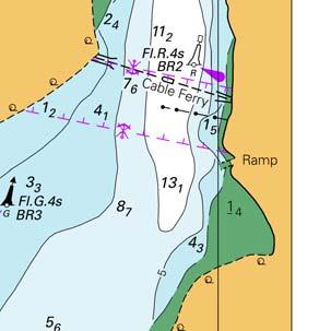
7 55 AUSTRALIA - QUEENSLAND - Moreton Bay - Coochiemudlo Island - Moorings Maritime Safety Queensland Aus 236 [54/2018] Insert legend, Moorings, centred on 27 34'.59 S '.73 E 56 AUSTRALIA - NORTHERN TERRITORY - Cape Stewart - Historic wreck northwards Department of Tourism and Culture NT Aus 717 [1065/2016] Insert safe clearance depth, 20m, enclosed by danger circle, with magenta 11 22'.42 S '.48 E legend Historic Wk with Protected Zone (see Note) restricted area with radius 0.43M, centred on 11 22'.55 S '.55 E Delete wreck 11 20'.0 S '.0 E Aus 718 [856/2017] Insert safe clearance depth, 20m, enclosed by danger circle, with magenta 11 22'.42 S '.48 E legend Historic Wk with Protected Zone (see Note) restricted area with radius 0.43M, centred on 11 22'.55 S '.55 E Delete wreck 11 20'.0 S '.0 E Aus 4603 (INT 603) [1020/2017] Replace dangerous wreck, with safe clearance depth, 20m, enclosed by danger circle, with legend Wk 11 20'.0 S '.0 E Aus 4720 (INT 720) [959/2017] Insert safe clearance depth, 20m, enclosed by danger circle, with legend Wk 11 22'.4 S '.5 E Delete wreck 11 20'.0 S '.0 E Aus 4721 (INT 721) [962/2017] Insert safe clearance depth, 20m, enclosed by danger circle, with legend Wk 11 22'.4 S '.5 E Delete wreck 11 20'.0 S '.0 E 57 AUSTRALIA - NORTHERN TERRITORY - Gove Harbour - Anchor berths Rio Tinto Aus 15 (plan, Gove Harbour) [406/2017] Insert anchor berth, desig G1, with 1296m radius swinging circle 12 10'.042 S '.164 E Delete anchor berth 12 10'.35 S '.24 E Aus 715 [813/2016] Insert anchor berth, desig G1, with 0.70M radius swinging circle 12 10'.04 S '.16 E anchor berth, desig G2, with 0.70M radius swinging circle 12 08'.62 S '.58 E anchor berth, desig G3, with 0.70M radius swinging circle 12 07'.26 S '.07 E Delete anchor berth 12 10'.4 S '.2 E anchor berth 12 09'.0 S '.0 E 58 AUSTRALIA - WESTERN AUSTRALIA - Exmouth Boat Harbour - Depth Department of Transport WA Aus 72 (plan, Exmouth Boat Harbour) [1080/2017] Insert depth, 2m, enclosed by contour 21 57'.403 S '.816 E Delete depth, 2 5 m 21 57'.39 S '.81 E 26 January
8 59 AUSTRALIA - WESTERN AUSTRALIA - Fremantle - Success Channel - Topmark Fremantle Ports Aus 117 [966/2017] Insert port lateral topmark 32 04'.997 S '.592 E 60 AUSTRALIA - WESTERN AUSTRALIA - Taunton Reef - Platform withdrawn; foul ground Quadrant Energy Aus 63 [607/2017] Insert accompanying block 21 18'.65 S '.10 E Aus 64 [858/2017] Insert accompanying block 21 18'.65 S '.10 E Replace pipeline, with disused pipeline, between 21 15'.5 S 21 17'.4 S '.9 E '.9 E Aus 328 [968/2017] Delete lit platform and restricted area, centred on 21 18'.5 S '.7 E Aus 743 [858/2017] Insert accompanying block 21 17'.75 S '.50 E Aus 4723 (INT 723) [1021/2017] Delete lit platform 21 18'.5 S '.7 E Aus 4725 (INT 725) [964/2017] Delete lit platform 21 18'.5 S '.7 E 61 AUSTRALIA - WESTERN AUSTRALIA - Wyndham - Cowan Patches to Roe Bank - Navaids; pilot boarding place; legend CGL Wyndham Port Aus 32 [1015/2017] Delete pilot boarding place 14 48'.9 S '.7 E Aus 32 (plan, Approaches to Wyndham Wharf) [1015/2017] Insert legend, Secondary Channel, centred on 15 19'.85 S '.57 E Replace beacon, with port lateral light beacon, Fl.R.3s No4, with topmark 15 18'.53 S '.53 E beacon, with port lateral light beacon, Fl.R.3s No6, with topmark 15 19'.10 S '.68 E Move lit raft buoy to 15 23'.31 S 15 23'.640 S '.44 E '.400 E Delete lit raft buoy 15 19'.97 S '.80 E Aus 318 [728/2017] Delete pilot boarding place 14 48'.9 S '.7 E Aus 726 [387/2016] Delete pilot boarding place 14 48'.9 S '.7 E 26 January
9 62 AUSTRALIA - SOUTH AUSTRALIA - Port Victoria - Navaids Department of Planning, Transport and Infrastructure SA Aus 776 [825/2017] Replace beacon with isolated danger light beacon, Fl(2)6s, with topmark 34 29'.7 S '.5 E Delete light and emanating light sectors with legends 34 29'.7 S '.8 E Aus 777 [1082/2017] Replace beacon with isolated danger light beacon, Fl(2)6s, with topmark 34 29'.7 S '.5 E Delete light and emanating light sectors with legends 34 29'.7 S '.8 E 63 AUSTRALIA - VICTORIA - Port Phillip - Portarlington - Infrastructure; navaids Former Notice - 846(T)/2017 is cancelled Parks Victoria Aus 143 [15/2018] Insert continuous line, between 38 06'.64 S 38 06'.63 S '.17 E '.45 E light, Fl.G.3s 38 06'.63 S '.45 E Delete light 38 06'.7 S '.2 E Aus 157 [1084/2017] Insert accompanying block A 38 07'.140 S '.800 E 64 AUSTRALIA - VICTORIA - Port Phillip - Corio Bay - Maintained depth limit Victorian Regional Channels Authority Aus 153 [1024/2017] Insert accompanying block 38 06'.4 S '.6 E Aus 157 [63/2018] Insert accompanying block B 38 07'.0 S '.8 E 65 AUSTRALIA - VICTORIA - Western Port - Phillip Island - Eastern Entrance - Topmark Australian Hydrographic Office Aus 150 [786/2017] Delete topmark 38 32'.6 S '.2 E Aus 150 (plan, Eastern Entrance to Western Port) [786/2017] Delete topmark 38 32'.61 S '.25 E 26 January
10 66 AUSTRALIA - TASMANIA - Foster Inlet - Depths LADS Flight Aus 179 (plan, Waterhouse Passage) [908/2017] Insert depth, 25 4 m, enclosed by contour 40 46'.12 S '.66 E rock which covers and uncovers enclosed by danger circle 40 48'.38 S '.22 E rock which covers and uncovers enclosed by danger circle 40 48'.21 S '.48 E Aus 179 (plan, Foster Inlet) [908/2017] Insert depth, 11 7 m 40 44'.567 S '.926 E contour, between 40 44'.731 S 40 44'.716 S 40 44'.519 S 40 44'.511 S '.881 E '.974 E '.055 E '.881 E depth, 1 4 m, enclosed by contour 40 44'.512 S '.179 E rock which covers and uncovers, enclosed by danger circle 40 44'.264 S '.193 E rock which covers and uncovers, enclosed by danger circle 40 44'.208 S '.598 E rock which covers and uncovers, enclosed by danger circle 40 44'.251 S '.655 E Replace depth, 15 3 m, with depth, 13 8 m 40 44'.80 S '.64 E depth, 3 7 m, with depth, 1 8 m 40 44'.44 S '.18 E Delete depth, 6 5 m 40 44'.54 S '.18 E contour, between 40 44'.92 S '.26 E 40 45'.21 S '.43 E Aus 798 [908/2017] Insert depth, 25 4 m, enclosed by contour 40 46'.12 S '.66 E depth, 11 7 m, enclosed by contour 40 44'.57 S '.93 E Replace depth, 15 3 m, with depth, 13 8 m, enclosed by contour 40 44'.8 S '.6 E Delete depth, 19 9 m, and enclosing contour 40 44'.7 S '.9 E 67 AUSTRALIA - TASMANIA - Great Oyster Bay - Depths LADS Flight Aus 169 (plan, Coles Bay) [907/2017] Insert rock which covers and uncovers, enclosed by danger circle 42 07'.607 S '.853 E Aus 169 (plan, Schouten Passage) [907/2017] Insert rock which covers and uncovers, enclosed by danger circle 42 13'.90 S '.16 E depth, 8 7 m, enclosed by contour 42 20'.79 S '.02 E Replace depth, 2 6 m, with depth, 1 9 m 42 17'.9 S '.0 E Aus 766 [416/2017] Insert depth, 8 4 m, enclosed by contour 42 08'.09 S '.13 E rock which covers and uncovers, enclosed by danger circle 42 13'.90 S '.16 E Replace depth, 15 9 m, with depth, 11 9 m 42 10'.1 S '.2 E depth, 2 6 m, with depth, 1 9 m 42 17'.9 S '.0 E 26 January
11 68 AUSTRALIA - TASMANIA - Hunter Island to Rocky Cape - Depths LADS Flight Aus 790 [977/2017] Insert depth,2 3 m, enclosed by contour 40 24'.40 S '.95 E depth, 15 4 m, enclosed by contour 40 25'.27 S '.64 E depth, 12 9 m, enclosed by contour 40 26'.96 S '.91 E depth, 8 7 m, enclosed by contour 40 28'.55 S '.79 E depth, 8 2 m, enclosed by contour 40 33'.00 S '.07 E rock which covers and uncovers, enclosed by danger circle 40 33'.39 S '.53 E depth, 13 1 m, enclosed by contour 40 30'.61 S '.16 E depth, 4m, enclosed by contour 40 35'.69 S '.77 E depth, 4 2 m, enclosed by contour 40 35'.24 S '.00 E depth, 1 1 m, enclosed by contour 40 42'.56 S '.72 E depth, 9 8 m, enclosed by contour 40 51'.24 S '.14 E Replace depth, 4 6 m, with legend Rep (1927), with depth, 2 9 m 40 22'.8 S '.0 E depth, 17 2 m, with depth, 8 2 m, enclosed by contour 40 50'.7 S '.6 E depth, 3 2 m, with depth, 1 4 m 40 50'.3 S '.1 E Delete depth, 15 6 m 40 30'.7 S '.1 E depth, 25 6 m 40 25'.1 S '.9 E depth, 6 9 m 40 24'.5 S '.7 E Aus 799 [513/2017] Insert depth, 9 8 m, enclosed by contour 40 51'.24 S '.14 E Replace depth, 17 2 m, with depth, 8 2 m, enclosed by contour 40 50'.7 S '.6 E depth, 3 2 m, with depth, 1 4 m 40 50'.3 S '.1 E 26 January
12 69 AUSTRALIA - TASMANIA - Stone Head to Round Hill Point - Depths LADS Flight Aus 163 [459/2017] Insert rock which covers and uncovers enclosed by danger circle 41 04'.336 S '.056 E depth, 8 7 m, and extend contour NE to enclose 41 04'.070 S '.246 E depth, 8 7 m, enclosed by contour 41 04'.210 S '.456 E depth, 2m, enclosed by contour 41 04'.584 S '.320 E Aus 164 [964/2016] Insert depth, 7 7 m, and extend contour N to enclose 41 05'.945 S '.980 E depth, 6 7 m, enclosed by contour 41 07'.153 S '.008 E depth, 14 9 m, enclosed by contour 41 06'.921 S '.852 E depth, 0 9 m, enclosed by contour 41 07'.983 S '.962 E depth, 6 1 m, enclosed by contour 41 07'.367 S '.607 E depth, 28 7 m, enclosed by contour 41 04'.871 S '.714 E depth, 1 5 m, enclosed by contour 41 09'.005 S '.984 E Replace depth, 12 3 m, with depth, 2 6 m, enclosed by contour 41 07'.93 S '.23 E depth, 1 2 m, with depth, 0 4 m 41 08'.62 S '.13 E depth, 3 2 m, with depth, 0 5 m, enclosed by contour 41 08'.68 S '.37 E Aus 164 (plan, Devonport) [964/2016] Insert depth, 8 8 m, enclosed by contour 41 09'.386 S '.495 E Aus 164 (plan, Ulverstone) [964/2016] Insert depth, 1 9 m, enclosed by contour 41 08'.579 S '.252 E depth, 0 4 m 41 08'.638 S '.103 E Replace depth, 3 2 m, with depth, 0 5 m, enclosed by contour 41 08'.68 S '.37 E Aus 167 [17/2018] Insert rock which covers and uncovers, enclosed by danger circle 41 04'.527 S '.272 E rock which covers and uncovers, enclosed by danger circle 41 04'.730 S '.516 E depth, 1 5 m, enclosed by contour 41 03'.220 S '.747 E Delete depth, 0 1 m 41 04'.53 S '.32 E Aus 487 [368/2017] Insert depth, 6 7 m, enclosed by contour 41 07'.15 S '.01 E Replace depth, 9 6 m, with depth, 7 7 m 41 06'.0 S '.0 E Aus 799 [68/2018] Insert depth, 8 7 m, enclosed by contour 41 04'.07 S '.25 E depth, 7 7 m, and extend contour N to enclose 41 05'.95 S '.98 E depth, 6 7 m, enclosed by contour 41 07'.15 S '.01 E depth, 0 9 m, enclosed by contour 41 07'.98 S '.96 E depth, 6 1 m, enclosed by contour 41 07'.37 S '.61 E depth, 28 7 m, enclosed by contour 41 04'.87 S '.71 E depth, 1 5 m, enclosed by contour 41 09'.01 S '.98 E depth, 1 5 m, enclosed by contour 41 03'.22 S '.75 E depth, 2m, enclosed by contour 41 04'.58 S '.32 E Replace depth, 12 3 m, with depth, 2 6 m, enclosed by contour 41 07'.9 S '.2 E depth, 0 3 m, with rock which covers and uncovers, enclosed by danger 41 04'.5 S '.3 E circle Delete depth, 13 5 m, and enclosing contour 41 07'.4 S '.9 E depth, 9 6 m, with legend Rep (1986) 41 06'.1 S '.0 E depth, 9 3 m 41 07'.9 S '.1 E depth, 10 1 m 41 04'.2 S '.2 E 26 January
13 70 SOLOMON ISLANDS - Kolombangara Island - Blackett Strait - Depths Secretariat of the Pacific Community SLB 102 (plan, Port Noro) [NC 11/8/2017] Insert depth, 9 3 m, enclosed by contour 08 15'.430 S '.566 E SLB 102 (plan, Blackett Strait) [NC 11/8/2017] Insert depth, 14 9 m, enclosed by contour 08 08'.30 S '.54 E depth, 18 9 m 08 08'.47 S '.97 E contour, between 08 08'.30 S 08 08'.52 S 08 08'.31 S '.98 E '.92 E '.30 E depth, 8 2 m, enclosed by contour 08 09'.19 S '.12 E depth, 28 1 m, enclosed by contour 08 08'.96 S '.23 E depth, 5 6 m, enclosed by contour 08 10'.07 S '.49 E depth, 5 3 m, enclosed by contour 08 10'.71 S '.08 E Delete contour, between 08 08'.3 S '.0 E 08 08'.3 S '.3 E depth, 27m 08 08'.5 S '.0 E 26 January
14 71(T)/2018 AUSTRALIA - NEW SOUTH WALES - Jervis Bay - Montagu Point - Beacon destroyed Department of Defence The beacon (35 01'.57 S '.68 E) has been destroyed. Chart temporarily affected - Aus (T)/2018 AUSTRALIA - QUEENSLAND - Fitzroy Island - Bird Rock - Light buoys Former Notice - 29(T)/2018 is cancelled Maritime Safety Queensland Notice 503(T)/2017 Two special light buoys, Fl.Y.2 5s exist in position 16 55'.43 S '.43 E. Chart temporarily affected - Aus (T)/2018 AUSTRALIA - QUEENSLAND - Great Sandy Strait - Dayman Point - Wreck charted Former Notice (T)/2016 is cancelled Maritime Safety Queensland Notice 4(T)/2018 Cancel this notice on receipt. Chart formerly affected - Aus Aus (T)/2018 AUSTRALIA - QUEENSLAND - Moreton Bay - Manly Boat Harbour - Dredging operations Maritime Safety Queensland The barge Faucon is conducting dredging operations in Manly Boat Harbour (27 27'.56 S '.38 E). The barges will display appropriate lights and shapes and will monitor VHF Ch 13 and 16. Mariners are advised to navigate with caution in the area. Chart temporarily affected - Aus (T)/2018 AUSTRALIA - QUEENSLAND - Slade Island - Light buoy off station Maritime Safety Queensland Notices 495(T), 501(T)/2017 The east cardinal light buoy, VQ(3)5s (21 06'.15 S '.51 E), is off station; an east cardinal light buoy, VQ(3) 5s, exists in position 21 06'.18 S '.34 E. Chart temporarily affected - Aus Aus (T)/2018 AUSTRALIA - QUEENSLAND - Wiepa - Albatross Bay - Scientific instruments Maritime Safety Queensland Notice 23(T)/2018 Subsurface scientific instruments marked by special light buoys, Fl.Y, exist in the following positions: 12 54'.38 S '.84 E 12 40'.79 S '.97 E 12 40'.43 S '.60 E 12 40'.28 S '.70 E 12 41'.54 S '.21 E. Chart temporarily affected - Aus 4 - Aus Aus (T)/2018 AUSTRALIA - NORTHERN TERRITORY - Darwin - Marine Supply Base - Light beacons relit Former Notice (T)/2017 is cancelled Department of Infrastructure, Planning and Logistics NT Notice 2/2018 Cancel this notice on receipt. Chart formerly affected - Aus January
15 78(T)/2018 AUSTRALIA - NORTHERN TERRITORY - Medina Inlet - Light buoy relit Former Notice - 773(T)/2016 is cancelled Department of Infrastructure, Planning and Logistics NT Cancel this notice on receipt. Chart formerly affected - Aus 23 - Aus 722 I 79(T)/2018 AUSTRALIA - WESTERN AUSTRALIA - Browse Island - Subsea operations completed northwestwards Former Notice - 386(T)/2017 is cancelled McDermott Australia Cancel this notice on receipt. Chart formerly affected - Aus Aus Aus Aus 4721 (INT 721) - Aus 4722 (INT 722) 80(T)/2018 AUSTRALIA - WESTERN AUSTRALIA - Rankin Bank - Subsea operations McDermott Australia Vessels LV108, DLV2000 and support vessels are conducting subsea operations in an area bounded by the following positions: 19 54'.81 S '.19 E 19 45'.03 S '.19 E 19 35'.03 S '.19 E 19 35'.02 S '.96 E 19 49'.81 S '.96 E 19 54'.80 S '.97 E. Mariners are advised to navigate with caution in the area. 2 5M clearance requested. Chart temporarily affected - Aus Aus 4723 (INT 723) 81(T)/2018 AUSTRALIA - WESTERN AUSTRALIA - Wyndham - Roe Bank - Shoaling CGL Wyndham Port Shoaling with a least depth of 4.3m exists in Secondary Channel (15 19'.85 S '.57 E). Mariners are advised to navigate with caution in the area. Chart temporarily affected - Aus 32 82(T)/2018 INDIAN OCEAN - Osborn Passage - Seismic survey completed Former Notice (T)/2017 is cancelled MV Polarcus Naila Cancel this notice on receipt. Chart formerly affected - Aus Aus Aus 4721 (INT 721) - Aus 4722 (INT 722) 26 January
16 83(T)/2018 RPS Group AUSTRALIA - VICTORIA - Ninety Mile Beach - Seismic survey MV Polarcus Naila, with a 5000m towed array, and support vessels Mermaid Vantage and Northern Star are conducting a seismic survey in an area bounded by the following positions: 38 18'.62 S '.50 E 38 08'.97 S '.58 E 38 08'.73 S '.40 E 38 08'.73 S '.75 E 38 10'.15 S '.62 E 38 10'.90 S '.18 E 38 12'.82 S '.20 E 38 21'.35 S '.60 E 38 21'.35 S '.03 E 38 21'.02 S '.83 E 38 19'.78 S '.53 E. Vessels will display appropriate lights and shapes. Mariners are advised to navigate with caution in the area. 6M clearance requested. Chart temporarily affected - Aus Aus (T)/2018 AUSTRALIA - VICTORIA - Port Campbell - Survey operations completed southwestwards Former Notice - 119(T)/2017 is cancelled Australian Maritime Safety Authority Auscoast Warning 4/2018 Cancel this notice on receipt. Chart formerly affected - Aus Aus (T)/2018 AUSTRALIA - VICTORIA - Port Phillip - Mornington - Light relit Former Notice - 223(T)/2016 is cancelled Parks Victoria Notice 012/2018 Cancel this notice on receipt. Chart formerly affected - Aus (T)/2018 AUSTRALIA - VICTORIA - Port Phillip - Corio Bay - Light buoys Former Notice - 945(T)/2017 is cancelled Victorian Regional Channels Authority Notices 16(T), 17(T)/2018 Starboard lateral pillar light buoys exist as follows: Position Remarks 38 06'.01 S '.92 E F.Iso.G.3s TB '.65 S '.34 E F.Iso.G.3s TB1 Chart temporarily affected - Aus Aus (T)/2018 AUSTRALIA - VICTORIA - Port Phillip - Yarra River - Light beacon unlit Victorian Ports Corporation (Melbourne) Notice 15(T)/2018 The starboard lateral light beacon, F.G & Fl.G.2s No25 (37 50'.80 S '.22 E) is unlit. Chart temporarily affected - Aus (T)/2018 AUSTRALIA - VICTORIA - Port Phillip - Webb Dock - Light beacon restored Former Notice (T)/2016 is cancelled Port of Melbourne Corporation Notice 312/2016 Cancel this notice on receipt. Chart formerly affected - Aus January
17 89(T)/2018 AUSTRALIA - BASS STRAIT - King Island - Scientific instrument Marine and Safety Tasmania Notice M6/2018 Subsurface scientific instruments exist in the following positions: 39 41'.17 S '.47 E 39 46'.00 S '.73 E 39 48'.06 S '.08 E. Chart temporarily affected - Aus (T)/2018 AUSTRALIA - BASS STRAIT - King Island - Scientific instruments recovered Former Notice (T)/2015 is cancelled Marine and Safety Tasmania Notice M173/2015 Cancel this notice on receipt. Chart formerly affected - Aus Aus AX 00487S 91(P)/2018 SOLOMON ISLANDS - Ghizo Island - Shoaling Secretariat of the Pacific Community Latest survey shows shoaler depths than those charted may exist in and around the islands and reefs in the area between Naru Island (8 08'.3 S '.1 E) and Sepo Island (8 03'.2 S E). Mariners are advised to navigate with caution in the area. Charts will be updated in due course. Chart which will be affected - SLB SLB SLB January
18 I HYDROGRAPHIC REPORTS NIL 26 January
19 II NAVIGATION WARNINGS The Australian Hydrographic Office will no longer compile Section III of the Australian Notices to Mariners. For the most up to date navigation warnings please refer to: AMSA Navigation Warnings New Zealand Notices to Mariners (Navarea XIV warnings) 26 January

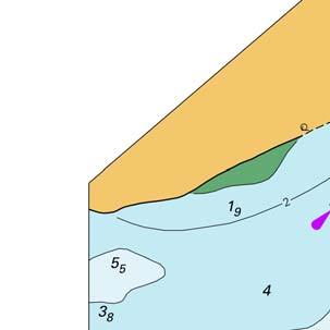
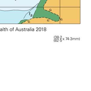
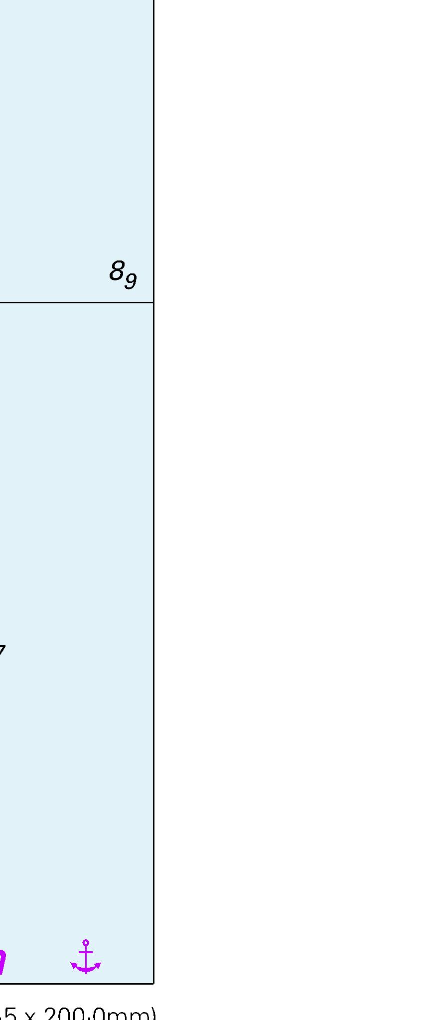
20 To accompany Australian Notice to Mariners 51/2018

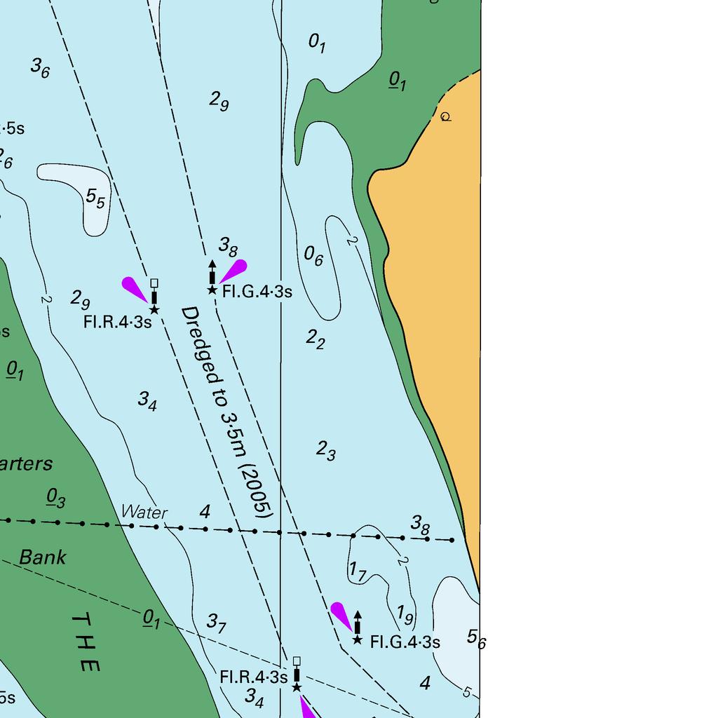
21 To accompany Australian Notice to Mariners 52/2018

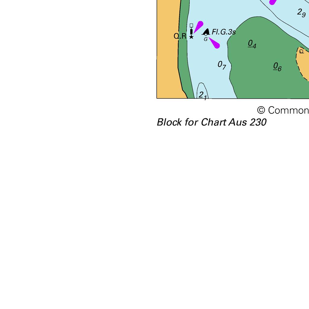
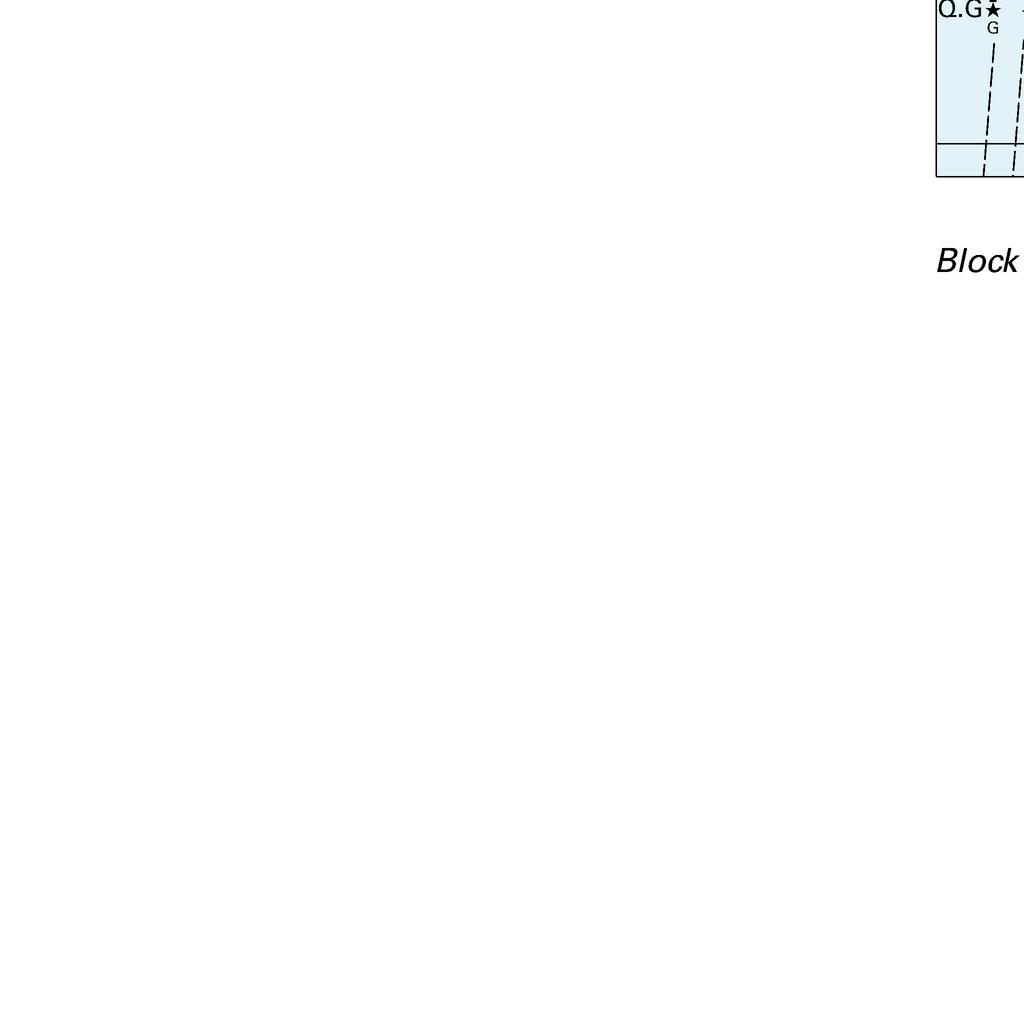
22 To accompany Australian Notice to Mariners 60/2018


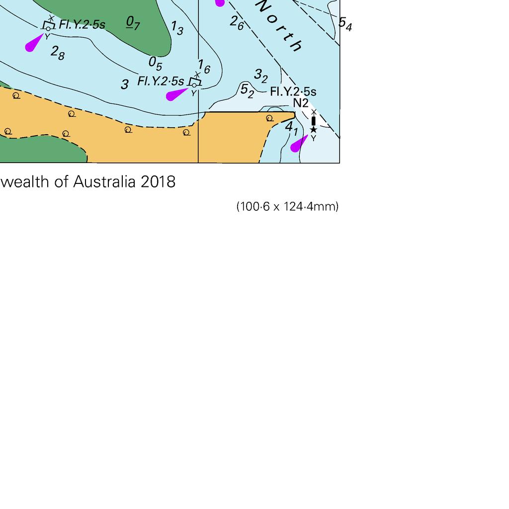
23 To accompany Australian Notice to Mariners 60/2018

24 To accompany Australian Notice to Mariners 60/2018

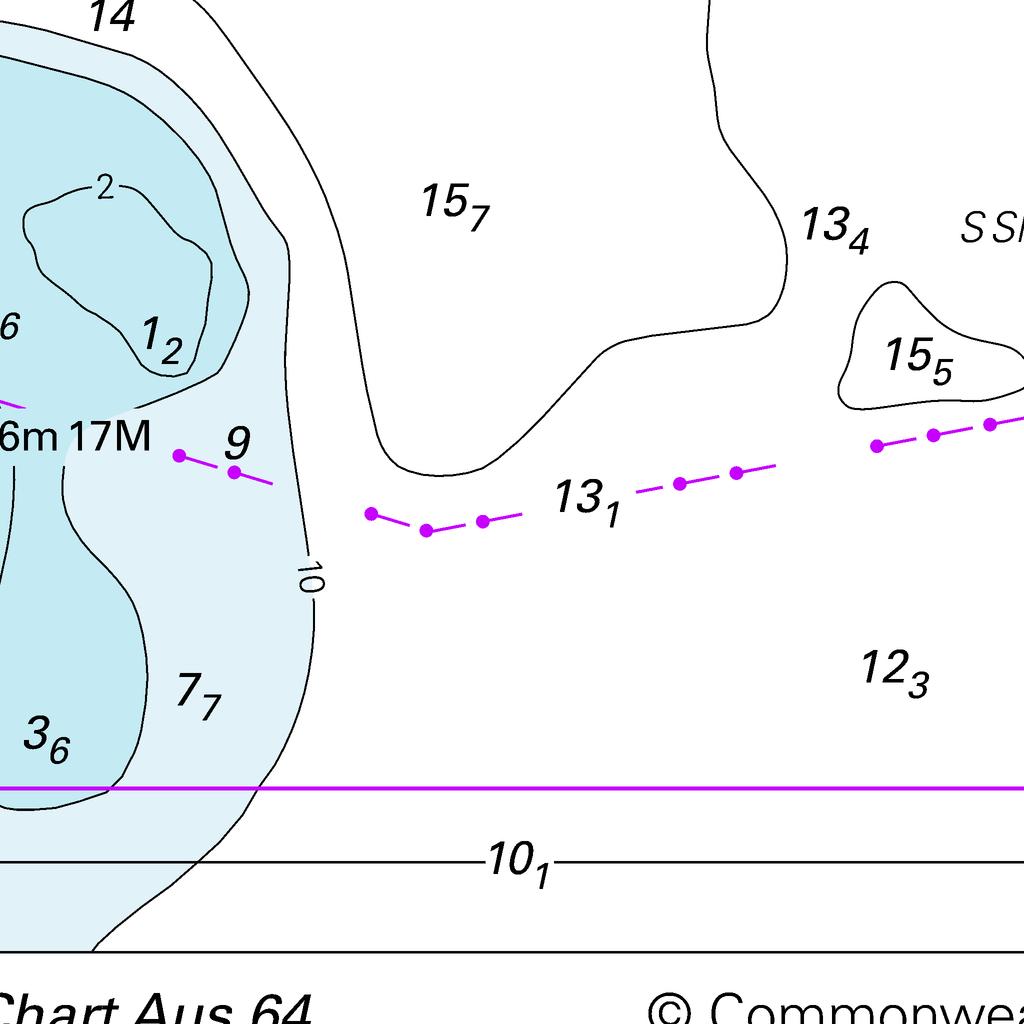
25 To accompany Australian Notice to Mariners 63/2018

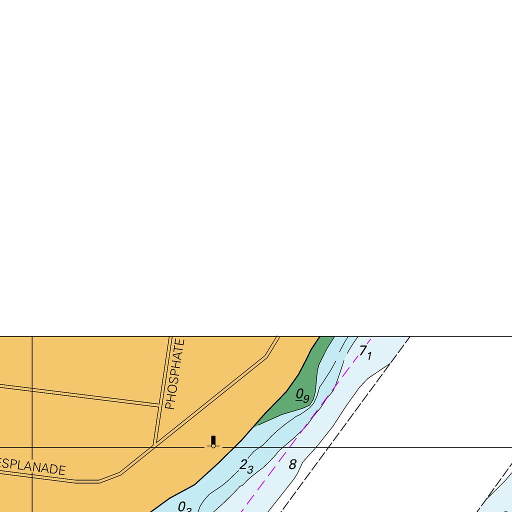
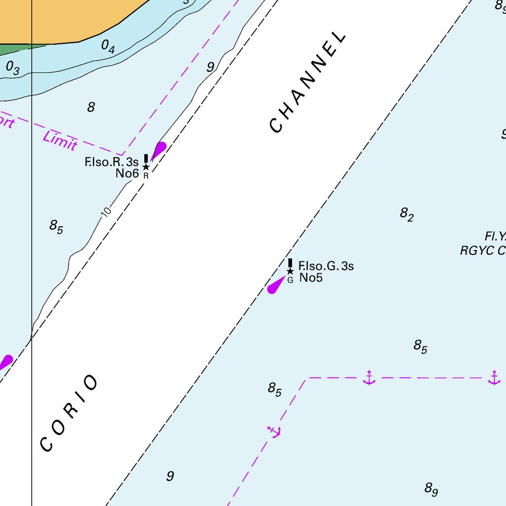
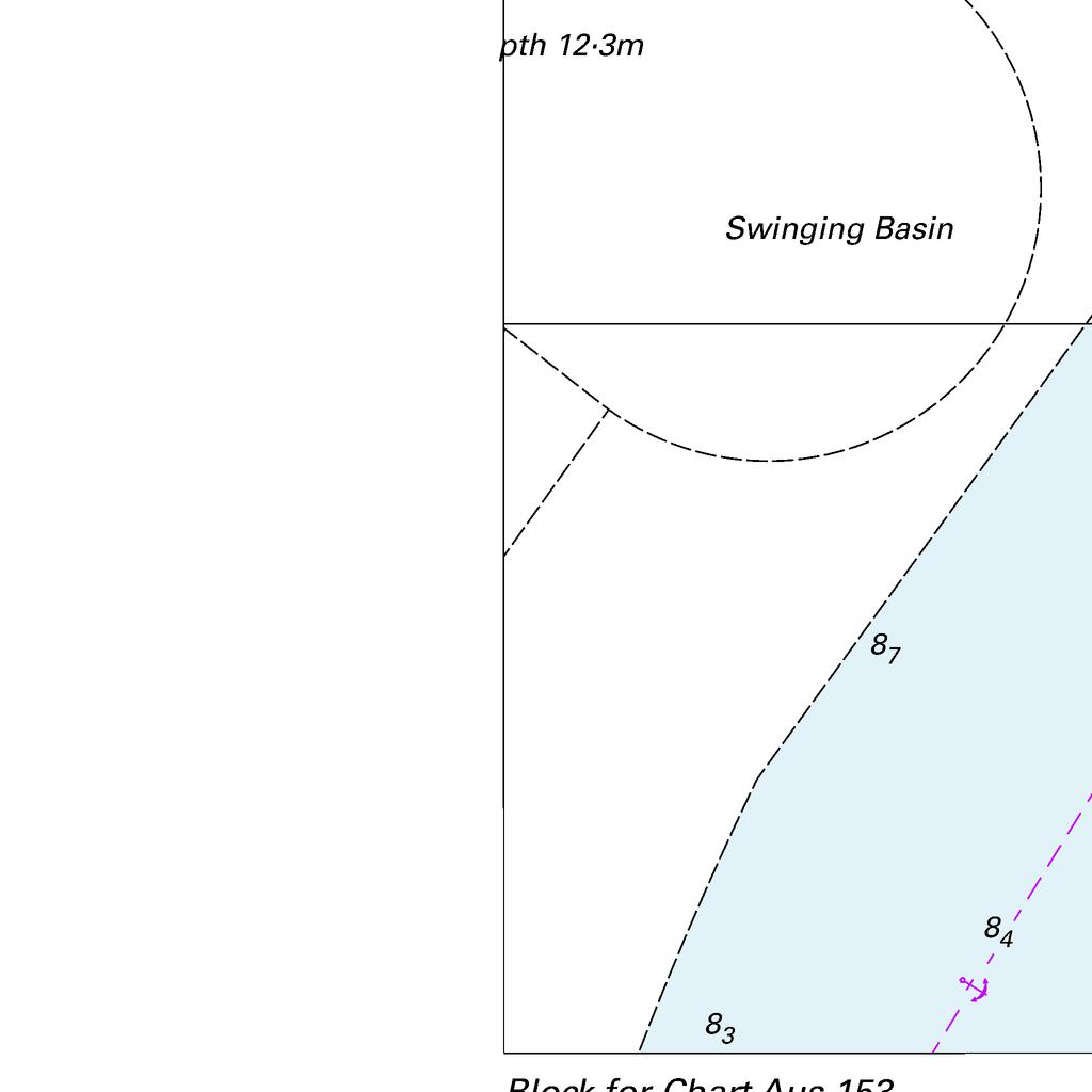
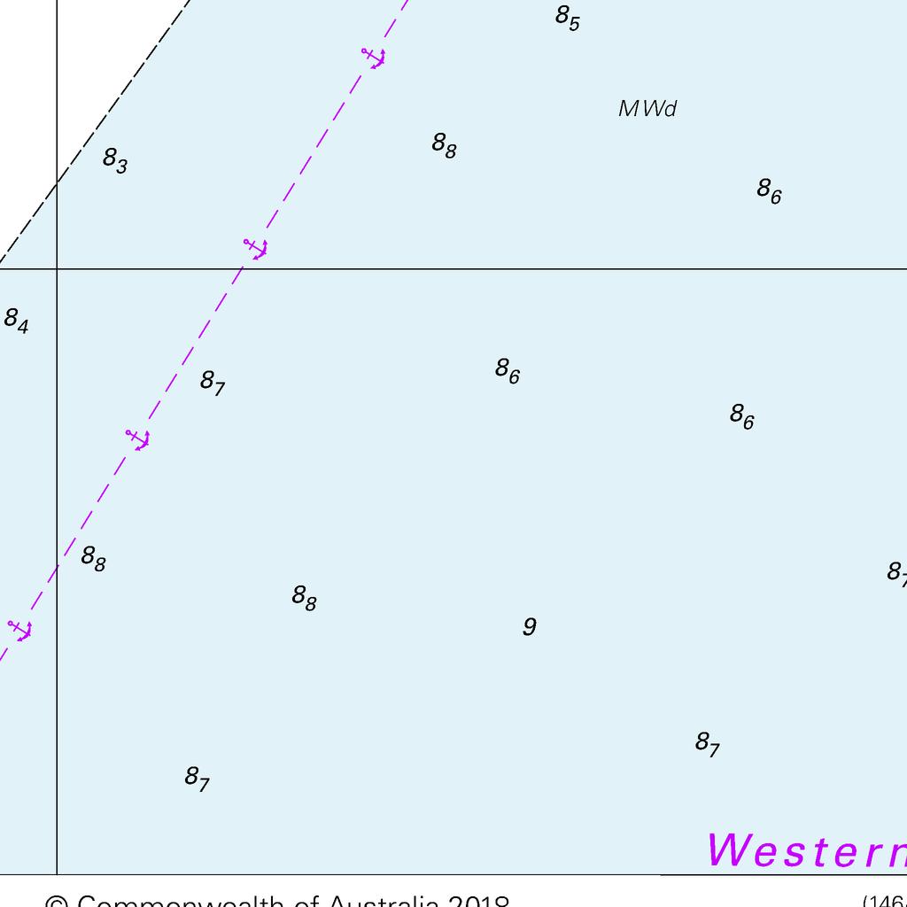
26 To accompany Australian Notice to Mariners 64/2018


27 To accompany Australian Notice to Mariners 64/2018
Admiralty Leisure Folio SC5601 East Devon and Dorset Coast, Exmouth to Christchurch
 Admiralty Leisure Folio SC5601 East Devon and Dorset Coast, Exmouth to Christchurch The Notices to Mariners (NMs) listed below apply to the latest edition of SC5601 (11 th Edition) published on 24 th March
RMYS News Please note the following notices to mariners issued by the Australian Hydrographic Service.
 RMYS News 2009 17 January 2009 Notices to Mariners Edition 1 39638 Wendell Raven, Saturday, 17 January 2009 Please note the following notices to mariners issued by the Australian Hydrographic Service.
112 INDIAN OCEAN, Îles Crozet - Depth. Depth 126m, extend 200m contour NW to enclose depth,. *113 NAMIBIA, Walvis Bay - Buoyage.
 I 1. 112 INDIAN OCEAN, Îles Crozet - Depth. Insert : Depth 126m, extend 200m contour NW to enclose depth,. in position 46 13.0 S., 051 20.0 E SAN Chart : 1 (50/00) Source : BA Notice 2928/98 (SAN 1) *113
SECTION I NM 5/17 CHART CORRECTIONS
 CHART CORRECTIONS 1116A 79Ed. 2/16 LAST NM 4/17 5/17 Delete Platform 28 22.9 N 90 32.1 W 11301 26Ed. 11/13 LAST NM 47/16 5/17 Delete Light 7 26 03 14 N 97 12 40 W 11302 34Ed. 1/14 LAST NM 15/16 5/17 (Side
NIGERIAN NOTICES TO MARINERS November 2017 EDITION PUBLISHED BY THE HYDROGRAPHIC OFFICE LAGOS. Notice 01 November 2017 Supplied Gratis
 NIGERIAN NOTICES TO MARINERS November 2017 EDITION PUBLISHED BY THE HYDROGRAPHIC OFFICE LAGOS Notice 01 November 2017 Supplied Gratis November 2017 CONTENTS I II Explanatory Notes and Index Nigerian Navy
Chart Features Maritime maps and Admiralty charts have these features:
 Introduction to Charts A chart or map of the area is an important safety item to carry on board. It allows the Master to obtain knowledge of the area to be travelled, and indicates the navigable channels
SECTION I NM 25/16 CHART CORRECTIONS
 CHART CORRECTIONS 12221 82Ed. 2/14 LAST NM 23/16 25/16 12224 26Ed. 8/14 LAST NM 23/16 25/16 12225 60Ed. 11/11 LAST NM 23/16 25/16 Delete Light PC 37 43 36 N 75 48 35 W Change Light to 8R Fl R 4s 15ft 4M
THE SYLLABUS FOR WRITTEN EXAMINATION PILOT'S FOURTH CLASS LICENCE (TEES AND HARTLEPOOL) AND
 AND") PD TEESPORT CONSERVANCY DIVISION HARBOUR MASTER'S OFFICE THE SYLLABUS FOR WRITTEN EXAMINATION IN RESPECT OF A PILOT'S FOURTH CLASS LICENCE (TEES AND HARTLEPOOL) AND PILOTAGE EXEMPTION CERTIFICATE (Issued
PD TEESPORT CONSERVANCY DIVISION HARBOUR MASTER'S OFFICE THE SYLLABUS FOR WRITTEN EXAMINATION IN RESPECT OF A PILOT'S FOURTH CLASS LICENCE (TEES AND HARTLEPOOL) AND PILOTAGE EXEMPTION CERTIFICATE (Issued
SECTION II NM 26/10 NAVIGATION PUBLICATIONS ALMANACS CORRECTIONS
 NAVIGATION PUBLICATIONS ALMANACS CORRECTIONS NAUTICAL ALMANAC Ed 2011 NEW EDITION (NGA) 26/10 SAILING DIRECTIONS CORRECTIONS PUB 140 8 Ed 2010 NEW EDITION (NGA) 26/10 COAST PILOT CORRECTIONS COAST PILOT
GVqQ(6)+LFl.15s, from: 56 16' 62N., 6 24' 91W.
+LFl.15s, from: 56 16' 62N., 6 24' 91W.") Leisure Folio SC5611 West Coast of Scotland, Mull of Kintyre to Point of Ardnamurchan The Notices to Mariners (NMs) listed below apply to the latest edition of SC5611 (6 th Edition) published on 18 th
Leisure Folio SC5611 West Coast of Scotland, Mull of Kintyre to Point of Ardnamurchan The Notices to Mariners (NMs) listed below apply to the latest edition of SC5611 (6 th Edition) published on 18 th
Orkney and Shetland Islands (2016)
") Clyde Cruising Club Amendments to Sailing Directions Clyde Cruising Club Publications Ltd. Orkney and Shetland Islands (2016) This PDF file contains all the amendments for the above volume of the CCC Sailing
Clyde Cruising Club Amendments to Sailing Directions Clyde Cruising Club Publications Ltd. Orkney and Shetland Islands (2016) This PDF file contains all the amendments for the above volume of the CCC Sailing
ROUTEING MEASURES OTHER THAN TRAFFIC SEPARATION SCHEMES
 E 4 ALBERT EMBANKMENT LONDON SE1 7SR Telephone: +44 (0)20 7735 7611 Fax: +44 (0)20 7587 3210 SN.1/Circ.317 4 December 2012 ROUTEING MEASURES OTHER THAN TRAFFIC SEPARATION SCHEMES 1 The Maritime Safety
MARINE NOTICE PORT OF DAMPIER
 Number: D9/2016 Date: 1/04/2016 Date of Effect: 1/04/2016 Details: Recommended Routes in Dampier Former Notice: Nil Charts & Publications: AUS 57, AUS58, AUS 59, AUS 60 and AUS 741 Further Notice: Attachments:
NEW ZEALAND NOTICES TO MARINERS
 EDITION 16 5 August 2016 NEW ZEALAND NOTICES TO MARINERS Notices NZ 171 178 Crown Copyright 2016. All rights Reserved. Permission is not required to make analogue copies of these Notices but such copies
NEW ZEALAND NOTICES TO MARINERS
 EDITION 15 21 July 2017 NEW ZEALAND NOTICES TO MARINERS Notices NZ 134 143 Crown Copyright 2017. All rights Reserved. Permission is not required to make analogue copies of these Notices but such copies
IALA Buoyage System and Visual Aids to Navigation. by Aleksandr D. Pipchenko
 IALA Buoyage System and Visual Aids to Navigation by Aleksandr D. Pipchenko IALA buoyage regions chart Which types of marks are provided by the system? Six types of marks provided by the system: Lateral
No JUNE 2017 UNITED STATES OF AMERICA. Contents
 23 10 JUNE 2017 UNITED STATES OF AMERICA Published Weekly by the National Geospatial-Intelligence Agency Prepared Jointly with the National Ocean Service and U.S. Coast Guard Contents Section I Chart Corrections............................................
ADANI PORTS & SEZ LTD. ++ MUNDRA PORT ++ GENERAL INFORMATION
 ADANI PORTS & SEZ LTD. ++ MUNDRA PORT ++ GENERAL INFORMATION LOCATION Mundra Port is all weather, independent, commercial port with geographical and hydrological advantages on the West Coast of India,
IMPORTANT ADMIRALTY CHART INFORMATION
 ADMIRALTY Charts affected by the Publication List [49/17] ADMIRALTY Charts International Charts 126 INT 1198 450 INT 1189 1491 INT 1468 1720 INT 1570 2245 INT 1580 2297 INT 1833 2486 INT 1845 2540 INT
[26/18] ADMIRALTY Charts affected by the Publication List. denotes chart available in the ADMIRALTY Raster Chart Service series. 1.
![[26/18] ADMIRALTY Charts affected by the Publication List. denotes chart available in the ADMIRALTY Raster Chart Service series. 1.](/thumbs/85/91343488.jpg "[26/18] ADMIRALTY Charts affected by the Publication List. denotes chart available in the ADMIRALTY Raster Chart Service series. 1.") ADMIRALTY Charts affected by the Publication List [26/18] ADMIRALTY Charts International Charts 88 INT 1220 551 INT 1460 798 INT 1462 945 INT 1510 1504 INT 1903 1606 INT 7258 1609 1792 ADMIRALTY Publications
ADMIRALTY Charts affected by the Publication List [26/18] ADMIRALTY Charts International Charts 88 INT 1220 551 INT 1460 798 INT 1462 945 INT 1510 1504 INT 1903 1606 INT 7258 1609 1792 ADMIRALTY Publications
No JULY 2012 UNITED STATES OF AMERICA. Contents
 30 28 JULY 2012 UNITED STATES OF AMERICA Published Weekly by the National Geospatial-Intelligence Agency Prepared Jointly with the National Ocean Service and U.S. Coast Guard Contents Section I Chart Corrections............................................
PILOTAGE INFORMATION
 PILOTAGE INFORMATION Revised A PILOTAGE DIRECTIONS The Gloucester Harbour Trustees is the Competent Harbour Authority for the Gloucester Harbour under the Pilotage Act 1987 and responsible for the provision
MARINE INFORMATION REPORT AND SUGGESTION SHEET INSTRUCTIONS
 MARINE INFORMATION REPORT AND SUGGESTION SHEET INSTRUCTIONS We value your suggestions to improve our products. The Marine Information Report and Suggestion Sheet is provided for users to submit corrective
Aids to navigation can include buoys, day beacons, range markers, and lighthouses.
 This boating safety course manual has been approved by Transport Canada strictly on the basis that it meets the minimum requirements of basic boating safety knowledge set out in Transport Canada s Boating
SECTION I NM 44/16 CHART CORRECTIONS
 CHART CORRECTIONS 1113A (INT 4148) Ed. 2/13 LAST NM 39/16 44/16 Add Buoy 1 G, Fl G 2.5s 26 40.3 N 82 18.9 W 1115A Ed. 10/10 LAST NM 41/16 44/16 11316 42Ed. 6/11 LAST NM 35/16 44/16 28 26 34 N 96 20 42
[43/17] ADMIRALTY Charts affected by the Publication List
![[43/17] ADMIRALTY Charts affected by the Publication List](/thumbs/92/109986113.jpg "[43/17] ADMIRALTY Charts affected by the Publication List") ADMIRALTY Charts affected by the Publication List [43/17] ADMIRALTY Charts International Charts 83 INT 1154 178 INT 1254 272 INT 1553 273 INT 1554 274 INT 1558 278 INT 1559 291 INT 1565 292 INT 2088 294
ADMIRALTY Charts affected by the Publication List [43/17] ADMIRALTY Charts International Charts 83 INT 1154 178 INT 1254 272 INT 1553 273 INT 1554 274 INT 1558 278 INT 1559 291 INT 1565 292 INT 2088 294
[07/18] Admiralty Charts affected by the Publication List. denotes chart available in the Admiralty Raster Chart Service series. 1.
![[07/18] Admiralty Charts affected by the Publication List. denotes chart available in the Admiralty Raster Chart Service series. 1.](/thumbs/77/75260142.jpg "[07/18] Admiralty Charts affected by the Publication List. denotes chart available in the Admiralty Raster Chart Service series. 1.") Admiralty Charts affected by the Publication List [07/18] ADMIRALTY Charts International Charts 105 INT 636 108 INT 1239 486 INT 1250 733 INT 1251 811 INT 1460 1218 INT 1548 1716 INT 1750 1719 INT 12511
Admiralty Charts affected by the Publication List [07/18] ADMIRALTY Charts International Charts 105 INT 636 108 INT 1239 486 INT 1250 733 INT 1251 811 INT 1460 1218 INT 1548 1716 INT 1750 1719 INT 12511
To be read in conjunction with the 2018 MYCQ Sailing Instructions, Revision H. RACE: The Great Bay Race TYPE: Summer 5
 SPECIAL SAILING INSTRUCTIONS To be read in conjunction with the 2018 MYCQ Sailing Instructions, Revision H. RACE: The Great Bay Race TYPE: Summer 5 DISTANCE: Approximately 65 NM DATE: Sat 3rd November
National Maritime Center
 National Maritime Center Providing Credentials to Mariners Able Seaman Unlimited, Limited, Special, Special OSV, Sail, Fishing Industry (Sample Examination) Page 1 of 17 Choose the best answer to the following
AUS small scale charts for coastal navigation. Scale: 1 to 150,000
 CHART-WORK SCALE Charts are available in different scales depending on their use. For passage planning you would use small scale charts and for close quarter manoeuvring you would use larger scale charts
OPERATIONS SEAFARER CERTIFICATION GUIDANCE NOTE SA MARITIME QUALIFICATIONS CODE. Deck: Chart Work
 Page 1 of 6 Compiled by Approved by Chief Examiner Syllabus Committee: 26 February 2013 OPERATIONS SEAFARER CERTIFICATION GUIDANCE NOTE SA MARITIME QUALIFICATIONS CODE Deck: Chart Work Page 2 of 6 COLUMN
Gorgon - Pilotage - Passage Plan - PBG to Gorgon Marine Terminal - Alternative Route
 1.0 Introduction This work instruction outlines the passage plan to be used by vessels transiting from the Port of Barrow Island PBG to the Gorgon Marine Terminal, via the alternative route, with a Pilot
No MAY 2017 UNITED STATES OF AMERICA. Contents
 21 27 MAY 2017 UNITED STATES OF AMERICA Published Weekly by the National Geospatial-Intelligence Agency Prepared Jointly with the National Ocean Service and U.S. Coast Guard Contents Section I Chart Corrections............................................
Ufs. No Notices to Mariners, SWEDEN Swedish Maritime Administration.
 Ufs No 726 2018-10-25 Notices to Mariners, SWEDEN Swedish Maritime Administration Editorial office Swedish Maritime Administration Ufs 601 78 NORRKÖPING Sweden tel: 0771 630 605 e-mail: ufs@sjofartsverket.se
CHAPTER I SUEZ CANAL NAVIGATION FEATURES SECTION 1 APPROACHES
 CHAPTER I SUEZ CANAL NAVIGATION FEATURES --------------------- SECTION 1 APPROACHES Art. 8 - PORT SAID: (See Admiralty Charts No. 234, 240 & 241 GENERAL: The Vessels coming from see fifteen miles before
AHO s experience on HD bathymetric ENCs
 AHO s experience on HD bathymetric ENCs ENCWG3 Wollongong 16 18 April 2018 Alvaro Sanchez DD Charting Quality Assurance, Standards and Specifications Australian Hydrographic Office Background 2016 As part
Anchoring Is Important
 BCC Sailing Classes - Third Theory Anchoring Anchoring Is Important 1 The Anchor is your last resort. Anchoring Keep off a lee shore. Needs to be shaped (type of anchor) to bury in the type of bottom for
SAILING INSTRUCTIONS MORETON BAY BOAT CLUB PEARL CHALLENGE 2017
 SAILING INSTRUCTIONS MORETON BAY BOAT CLUB PEARL CHALLENGE 2017 Saturday 17 th June and Sunday 18 th June 2017 Organising Authority Moreton Bay Boat Club Inc. at the Redcliffe Peninsula 1. RULES The event
Ufs. No Notices to Mariners, SWEDEN Swedish Maritime Administration.
 Ufs No 617 2016-09-22 Notices to Mariners, SWEDEN Swedish Maritime Administration Editorial office Swedish Maritime Administration Ufs 601 78 NORRKÖPING Sweden tel: 0771 630 605 e-mail: ufs@sjofartsverket.se
Vlaanderen is maritiem. Notices to Mariners OSTEND 16 FEBRUARY 2017 NR. 04.
 Vlaanderen is maritiem Notices to Mariners OSTEND 16 FEBRUARY 2017 NR. 04 www.vlaamsehydrografie.be 1 GENERAL NOTICES 2017-04/071 LOWER SEA SCHELDT - ANTWERP SCHELDT QUAYS: SHIPS DESTINED FOR SCHELDT
DISCUSSION PAPER: NEW GENERALISATION POLICY FOR SMALL SCALE ADMIRALTY CHARTS.
 DISCUSSION PAPER: NEW GENERALISATION POLICY FOR SMALL SCALE ADMIRALTY CHARTS. PREFACE. Throughout this paper we will be making reference to largest scale, second scale, third scale coverage on an SNC (Standard
Visiting Lake Macquarie
 Visiting Lake Macquarie Lake Macquarie is the largest coastal salt water lake in Australia and is a prime boating destination for both small and large vessels. Many sailing regattas and fishing activities
[24/17] ADMIRALTY Charts affected by the Publication List. denotes chart available in the ADMIRALTY Raster Chart Service series. 1.
![[24/17] ADMIRALTY Charts affected by the Publication List. denotes chart available in the ADMIRALTY Raster Chart Service series. 1.](/thumbs/74/71362435.jpg "[24/17] ADMIRALTY Charts affected by the Publication List. denotes chart available in the ADMIRALTY Raster Chart Service series. 1.") ADMIRALTY Charts affected by the Publication List [24/17] ADMIRALTY Charts International Charts 67 INT 7352 110 INT 7418 172 INT 2806 269 INT 1609 534 INT 1163 538 INT 1416 1383 INT 1473 1410 2076 ADMIRALTY
ADMIRALTY Charts affected by the Publication List [24/17] ADMIRALTY Charts International Charts 67 INT 7352 110 INT 7418 172 INT 2806 269 INT 1609 534 INT 1163 538 INT 1416 1383 INT 1473 1410 2076 ADMIRALTY
Chapter 8. Port hand buoy. Starboard hand buoy. Canadian Aids to Navigation System (CANS) 8.1 Introduction. 8.2 Lateral Buoys
 8.1 Introduction. 8.2 Lateral Buoys") Chapter 8 Canadian Aids to Navigation System (CANS) 8.1 Introduction Various buoys, beacons and signs are known as "Aids to Navigation" or "Navigation Aids". They are devices or systems external to the
Chapter 8 Canadian Aids to Navigation System (CANS) 8.1 Introduction Various buoys, beacons and signs are known as "Aids to Navigation" or "Navigation Aids". They are devices or systems external to the
A buoy, for example is an aid to navigation. Aids to navigation include many types of buoys as well as day beacons, range markers, and lighthouses.
 This online study guide has been approved by Transport Canada strictly on the basis that it meets the requirements of the Standard for Pleasure Craft Operator Testing over the Internet (TP 15080E) and
Movement and traffic procedures
 Section 3 Movement and traffic procedures Maritime Safety Queensland, through the authority of the Regional Harbour Master, has jurisdiction over the safe movement of all shipping within the pilotage area.
NEW ZEALAND NOTICES TO MARINERS
 NEW ZEALAND NOTICES TO MARINERS Notices NZ 170 181 Crown Copyright 2015. All rights Reserved. Permission is not required to make analogue copies of these Notices but such copies are not to be sold. I II
MARINE SAFETY REGULATION 2016 EXEMPTION ORDER. Clause 140(1)
") MARINE SAFETY REGULATION 2016 EXEMPTION ORDER Clause 140(1) I, Angus Mitchell, Executive Director, NSW Maritime, a delegate of Roads and Maritime Services (RMS), pursuant to clause 140(1) of the Marine
MARINE SAFETY REGULATION 2016 EXEMPTION ORDER Clause 140(1) I, Angus Mitchell, Executive Director, NSW Maritime, a delegate of Roads and Maritime Services (RMS), pursuant to clause 140(1) of the Marine
NOTICE of RACE. Revision 1 Page 1 of 8 6 August 2012
 NOTICE of RACE MORETON BAY YACHT CLUB FAIRWAY CHALLENGE 2012 Revision 1 Page 1 of 8 6 August 2012 1.1 Preamble 1.0 INVITATION and EVENT DESCRIPTION The Moreton Bay Yacht Club invites eligible yachts to
COXSWAIN NAVIGATION EXERCISES AUS197 NAME:
 COXSWAIN NAVIGATION EXERCISES AUS197 NAME: A deviation card is supplied at the end of this file. Check the answers Question 1 Using any chart (or use the AUS 197 extract) to: 1. Identify a distance of
National Maritime Center
 National Maritime Center Providing Credentials to Mariners (Sample Examination) Page 1 of 16 Choose the best answer to the following Multiple Choice Questions. 1. On U.S. charts, you can tell if a named
EfFl(5)Y.20s 53 13' 0N., 4 43' 4W.
Y.20s 53 13' 0N., 4 43' 4W.") Admiralty Leisure Folio SC5609 North West Wales including Menai Strait The Notices to Mariners (NMs) listed below apply to the latest edition of SC5609 (4 th Edition) published on 22 nd March 2018. Temporary/Preliminary
Admiralty Leisure Folio SC5609 North West Wales including Menai Strait The Notices to Mariners (NMs) listed below apply to the latest edition of SC5609 (4 th Edition) published on 22 nd March 2018. Temporary/Preliminary
Ufs. No Notices to Mariners, SWEDEN Swedish Maritime Administration.
 Ufs No 689 2018-02-08 Notices to Mariners, SWEDEN Swedish Maritime Administration Editorial office Swedish Maritime Administration Ufs 601 78 NORRKÖPING Sweden tel: 0771 630 605 e-mail: ufs@sjofartsverket.se
NEW ZEALAND NOTICES TO MARINERS
 NEW ZEALAND NOTICES TO MARINERS Notices NZ 53 66 Crown Copyright 2017. All rights Reserved. Permission is not required to make analogue copies of these Notices but such copies are not to be sold. I I IV
LIST OF CORRECTIONS. 02 / January /052(T) - 07/125(T) - 08/136(T) - 08/137(T) - 12/177(T) - 15/212(T) - 18/232-22/285(T)
 - 07/125(T) - 08/136(T) - 08/137(T) - 12/177(T) - 15/212(T) - 18/232-22/285(T)") LIST OF CORRECTIONS 105 Chart Kanaal van Gent naar Terneuzen Edition 2016 Updated up to and including NMs 02 / 2018 18 January 2018 The last version of these corrections are available on www.vlaamsehydrografie.be
LIST OF CORRECTIONS 105 Chart Kanaal van Gent naar Terneuzen Edition 2016 Updated up to and including NMs 02 / 2018 18 January 2018 The last version of these corrections are available on www.vlaamsehydrografie.be
Ufs. No Notices to Mariners, SWEDEN Swedish Maritime Administration.
 Ufs No 537 2015-03-12 Notices to Mariners, SWEDEN Swedish Maritime Administration Editorial office Swedish Maritime Administration Ufs 601 78 NORRKÖPING Sweden tel: 0771 630 605 e-mail: ufs@sjofartsverket.se
V Complying with IHO S-52/S-63/S-64
 Model FEA-2107/2807 V.06.50 Complying with IHO S-52/S-63/S-64 The software has been upgraded to V.06.50 in accordance with the IHO standards. IHO S-52 Ed. 6.1.1 Specifications for Chart Contents and Display
SAILING INSTRUCTIONS BILLY RUN. Saturday 28 April The organising authority (OA) is the South of Perth Yacht Club
 is the South of Perth Yacht Club") SAILING INSTRUCTIONS BILLY RUN Saturday 28 April 2018 The organising authority (OA) is the South of Perth Yacht Club 1. RULES 1.1. The regatta will be governed by the rules as defined in The Racing Rules
SAILING INSTRUCTIONS BILLY RUN Saturday 28 April 2018 The organising authority (OA) is the South of Perth Yacht Club 1. RULES 1.1. The regatta will be governed by the rules as defined in The Racing Rules
Ufs. No Notices to Mariners, SWEDEN Swedish Maritime Administration.
 Ufs No 509 2014-08-28 Notices to Mariners, SWEDEN Swedish Maritime Administration Editorial office Swedish Maritime Administration Ufs/BALTICO 601 78 NORRKÖPING Sweden tel: 0771 630 605 e-mail: ufs@sjofartsverket.se
LIST OF CORRECTIONS. 14 / July /052(T) - 07/125(T) - 08/136(T) - 08/137(T) - 12/177(T) - 15/212(T) - 18/232-22/285(T)
 - 07/125(T) - 08/136(T) - 08/137(T) - 12/177(T) - 15/212(T) - 18/232-22/285(T)") LIST OF CORRECTIONS 105 Chart Kanaal van Gent naar Terneuzen Edition 2016 Updated up to and including NMs 14 / 2018 05 July 2018 The last version of these corrections are available on www.vlaamsehydrografie.be
LIST OF CORRECTIONS 105 Chart Kanaal van Gent naar Terneuzen Edition 2016 Updated up to and including NMs 14 / 2018 05 July 2018 The last version of these corrections are available on www.vlaamsehydrografie.be
NOTICES TO MARINERS 1 to 46 ANNUAL EDITION 2018
 NOTICES TO MARINERS 1 to 46 CANADIAN COAST GUARD www.notmar.gc.ca Notices to Mariners 1 to 46 Annual Edition 2018 Published under the authority of: Canadian Coast Guard Programs Aids to Navigation and
Gorgon - Pilotage - Passage Plan PBG to Materials Offloading Facility (MOF)
") 1.0 Introduction Vessels transiting within port limits from the Barrow Island Pilot Boarding Ground (PBG) to the require an approved passage plan which can be shared between Pilots and vessel Masters.
1.0 Introduction Vessels transiting within port limits from the Barrow Island Pilot Boarding Ground (PBG) to the require an approved passage plan which can be shared between Pilots and vessel Masters.
Mike Harvey Memorial Race
 Mike Harvey Memorial Race Fremantle Sailing Club to Hillarys Yacht Club Saturday 28 th January 2017 Supplementary Sailing Instructions 1 RULES 1.1 The Fremantle Sailing Club Sailing Handbook 2016-1017
NEW ZEALAND NOTICES TO MARINERS
 EDITION 3 NEW ZEALAND NOTICES TO MARINERS Notices NZ 31 39 Crown Copyright 2018. All rights Reserved. Permission is not required to make analogue copies of these Notices but such copies are not to be sold.
Gorgon - Pilotage - Passage Plan Materials Offloading Facility (MOF) to PBG
 to PBG") Gorgon - Pilotage - Passage Plan Materials Offloading Facility (MOF) to PBG 1.0 Introduction Vessels transiting within port limits from the Materials Offloading Facility (MOF) to the Barrow Island Pilot
Gorgon - Pilotage - Passage Plan Materials Offloading Facility (MOF) to PBG 1.0 Introduction Vessels transiting within port limits from the Materials Offloading Facility (MOF) to the Barrow Island Pilot
SAILING INSTRUCTIONS
 COMMODORE S CUP OCEAN RACE 2007 Night Race - Thursday 25 January 2007 Day Race - Friday 26 January 2007 COMMODORE S CUP OCEAN RACE (Mooloolaba Manly) - Saturday 27 January 2007 Passage Race - Sunday 28
[25/16] Admiralty Charts affected by the Publication List
![[25/16] Admiralty Charts affected by the Publication List](/thumbs/84/89125660.jpg "[25/16] Admiralty Charts affected by the Publication List") Admiralty Charts affected by the Publication List [25/16] Admiralty Chart Admiralty Publications 61 NP 285 110 123 243 244 259 305 346 1186 1216 1258 1502 1792 1859 2151 2171 2199 2411 2638 2692 2770 3359
Admiralty Charts affected by the Publication List [25/16] Admiralty Chart Admiralty Publications 61 NP 285 110 123 243 244 259 305 346 1186 1216 1258 1502 1792 1859 2151 2171 2199 2411 2638 2692 2770 3359
Delaware River Vessel Reporting System Mariners Advisory Committee For
 Delaware River Vessel Reporting System Mariners Advisory Committee For the Bay and River Delaware The Mariner's Advisory Committee is comprised of Master Mariners, River Pilots, and concerns itself with
[09/18] Admiralty Charts affected by the Publication List. denotes chart available in the Admiralty Raster Chart Service series. 1.
![[09/18] Admiralty Charts affected by the Publication List. denotes chart available in the Admiralty Raster Chart Service series. 1.](/thumbs/84/89739993.jpg "[09/18] Admiralty Charts affected by the Publication List. denotes chart available in the Admiralty Raster Chart Service series. 1.") Admiralty Charts affected by the Publication List [09/18] ADMIRALTY Charts International Charts 486 INT 1239 701 INT 1250 733 INT 1251 811 INT 1548 1218 INT 1625 1794 INT 12511 2211 2943 3818 3819 4122
Admiralty Charts affected by the Publication List [09/18] ADMIRALTY Charts International Charts 486 INT 1239 701 INT 1250 733 INT 1251 811 INT 1548 1218 INT 1625 1794 INT 12511 2211 2943 3818 3819 4122
Bathymetry User Needs and Challenges in Australia and New Zealand
 Bathymetry User Needs and Challenges in Australia and New Zealand Nathan Quadros nquadros@crcsi.com.au Shallow Water Survey February 212 Background Recent significant investment in Bathymetric LiDAR acquisition
BookletChart. Intracoastal Waterway Matecumbe to Grassy Key NOAA Chart A reduced-scale NOAA nautical chart for small boaters
 BookletChart Intracoastal Waterway Matecumbe to Grassy Key NOAA Chart 11449 A reduced-scale NOAA nautical chart for small boaters When possible, use the full-size NOAA chart for navigation. Published by
Paper for consideration by ENC Working Group. Use of AU6 ENC cells as an option for Bathymetric ENCs (benc)
") Paper for consideration by ENC Working Group Use of AU6 ENC cells as an option for Bathymetric ENCs (benc) Submitted by: Alvaro Sanchez (AHS) Executive Summary: Compilation of high density bathymetric
Paper for consideration by ENC Working Group Use of AU6 ENC cells as an option for Bathymetric ENCs (benc) Submitted by: Alvaro Sanchez (AHS) Executive Summary: Compilation of high density bathymetric
SECTION I NM 52/16 CHART CORRECTIONS
 SECTION I NM 52/16 CHART CORRECTIONS 62 (INT 62) 3Ed. 6/22/96 LAST NM 28/16 52/16 Delete Depth 16 meters, blue tint and enclosing 12 14 S 77 37 W (2(143)13 Taunn) 501 (INT 801) 13Ed. 6/09 LAST NM 39/16
COMBINED OCEAN POINTSCORE SAILING INSTRUCTIONS 2018 / 2019
 COMBINED OCEAN POINTSCORE NEWCASTLE CRUISING YACHT CLUB LAKE MACQUARIE YACHT CLUB SAILING INSTRUCTIONS 2018 / 2019 1 1 RULES 1.1 The event will be governed by the rules as defined in The Racing Rules of
REGION B ONLY. Figure Figure Figure Figure Figure Figure Figure Figure 10.60
 221 REGION B ONLY 10.5 LATERAL MARKS 10.5.1 Description of Lateral marks Port hand marks Shape: pillar buoy (Figures 10.53 and 10.54), can lighted buoy (Figures 10.55 and 10.56) or not lighted (Figures
CHAPTER 8 BUOYAGE 8.1 GENERAL
 145 CHAPTER 8 BUOYAGE 8.1 GENERAL The term `buoyage encompasses all floating structure such as buoys or beacons which are used to orientate mariners and to mark the edges of navigable channels and fairways.
ICES Guidelines for Multibeam Echosounder Data (Compiled September 2006)
") ICES Guidelines for Multibeam Echosounder Data (Compiled September 2006) If you are considering producing a hydrographic survey please read the following information first. Your survey could be used to
ICES Guidelines for Multibeam Echosounder Data (Compiled September 2006) If you are considering producing a hydrographic survey please read the following information first. Your survey could be used to
Balmain Sailing Club 2017 Spring Series Sailing Instructions - Keelboats
 Race Schedule Balmain Sailing Club 2017 Spring Series Sailing Instructions - Keelboats September 3, 2017 Race 1 September 17, 2017 Race 2 Birchgrove Cup October 8, 2017 Race 3 October 22, 2017 Race 4 November
Harbourmaster s Office Tamaki River. Navigation Safety Operating Requirements 2014
 Harbourmaster s Office Tamaki River Navigation Safety Operating Requirements 2014 Auckland Council Harbourmaster s Office TAMAKI RIVER Navigation Safety Operating Requirements FOREWARD The purpose of these
Ufs. No Notices to Mariners, SWEDEN Swedish Maritime Administration.
 Ufs No 731 2018-11-29 Notices to Mariners, SWEDEN Swedish Maritime Administration Editorial office Swedish Maritime Administration Ufs 601 78 NORRKÖPING Sweden tel: 0771 630 605 e-mail: ufs@sjofartsverket.se
INTERNATIONAL HYDROGRAPHIC ORGANIZATION
 INTERNATIONAL HYDROGRAPHIC ORGANIZATION S-67 MARINERS GUIDE TO ACCURACY OF ELECTRONIC NAVIGATIONAL CHARTS (ENC) Edition 0.5 July 2017 Copyright International Hydrographic Organization 2017 This work is
West Coast Anchorages
 West Coast Anchorages This document aims to catalogue a number of anchorages along the West Coast of Tasmania where shelter may be sought. In addition the degree of protection from the wind, and holding
LIST OF CORRECTIONS. INT Belg. 101 Chart
 LIST OF CORRECTIONS INT 1474 - Belg. 101 Chart Monding Westerschelde Edition December 2018 Updated up to and including NMs 5 / 2019 28 February 2019 The last version of these corrections are available
SECTION II NM 11/13 NAVIGATION PUBLICATIONS COAST PILOT CORRECTIONS. Chapter 4 Paragraphs 85 to 86; read: (85)
") NAVIGATION PUBLICATIONS COAST PILOT CORRECTIONS COAST PILOT 1 42 Ed 2012 Change No. 13 LAST NM 9/13 Chapter 4 Paragraph 9; read: (9) Round Rock, which uncovers, and The Boring Stone, 3 feet high and bare,
NAVIGATION PUBLICATIONS COAST PILOT CORRECTIONS COAST PILOT 1 42 Ed 2012 Change No. 13 LAST NM 9/13 Chapter 4 Paragraph 9; read: (9) Round Rock, which uncovers, and The Boring Stone, 3 feet high and bare,
Stars and Compass Trophy and Novice Paper 2014!
 Stars and Compass Trophy and Novice Paper 2014 The Stars and Compass Trophy was established to promote the use and development of traditional navigation skills. This year, in a bid to encourage novice
TICES TO MARINERS 1 TO 46 ANNUAL EDITION 2018 SECTION A AIDS TO NAVIGATION AND MARINE SAFETY
 A5 NAVIGATION SAFETY 10 Routeing of Ships 1 GENERAL 1.1 Rule 10 of the Collision Regulations applies to all ships navigating in or near a routeing system. 1.2 The information on ships' routeing in this
BookletChart. Chesapeake Bay Tangier Sound, Northern Part NOAA Chart A reduced-scale NOAA nautical chart for small boaters
 BookletChart Chesapeake Bay Tangier Sound, Northern Part NOAA Chart 12231 A reduced-scale NOAA nautical chart for small boaters When possible, use the full-size NOAA chart for navigation. Published by
Ufs. No Notices to Mariners, SWEDEN Swedish Maritime Administration.
 Ufs No 590 2016-03-17 Notices to Mariners, SWEDEN Swedish Maritime Administration Editorial office Swedish Maritime Administration Ufs 601 78 NORRKÖPING Sweden tel: 0771 630 605 e-mail: ufs@sjofartsverket.se
Balmain Sailing Club Friday Twilight Series Sailing Instructions. Yachts & Dinghies
 Balmain Sailing Club 2015-2016 Friday Twilight Series Sailing Instructions Yachts & Dinghies Race Schedule Friday Twilight Races Pre-Christmas Twilight Series 11 Friday evening races: 1800 start 9, 16,
Ufs. No Notices to Mariners, SWEDEN Swedish Maritime Administration.
 Ufs No 510 2014-09-04 Notices to Mariners, SWEDEN Swedish Maritime Administration Editorial office Swedish Maritime Administration Ufs/BALTICO 601 78 NORRKÖPING Sweden tel: 0771 630 605 e-mail: ufs@sjofartsverket.se
Balmain Sailing Club Friday Twilight Series Sailing Instructions. Yachts & Dinghies
 Balmain Sailing Club 2014-2015 Friday Twilight Series Sailing Instructions Yachts & Dinghies Race Schedule Friday Twilight Races Pre-Christmas Twilight Series 11 Friday evening races: 1800 start 10, 17,
Ufs. No Notices to Mariners, SWEDEN Swedish Maritime Administration.
 Ufs No 636 2017-02-02 Notices to Mariners, SWEDEN Swedish Maritime Administration Editorial office Swedish Maritime Administration Ufs 601 78 NORRKÖPING Sweden tel: 0771 630 605 e-mail: ufs@sjofartsverket.se
NEW ZEALAND NOTICES TO MARINERS
 NEW ZEALAND NOTICES TO MARINERS Notices NZ 24 29 Crown Copyright 2017. All rights Reserved. Permission is not required to make analogue copies of these Notices but such copies are not to be sold. I I IV
Ufs. No Notices to Mariners, SWEDEN Swedish Maritime Administration.
 Ufs No 584 2016-02-04 Notices to Mariners, SWEDEN Swedish Maritime Administration Editorial office Swedish Maritime Administration Ufs 601 78 NORRKÖPING Sweden tel: 0771 630 605 e-mail: ufs@sjofartsverket.se
SAILING INSTRUCTIONS
 SAILING INSTRUCTIONS 182nd AUSTRALIA DAY REGATTA ON SYDNEY HARBOUR Friday 26 January 2018 CONDUCTED BY ROYAL SYDNEY YACHT SQUADRON ON BEHALF OF AUSTRALIA DAY MANAGEMENT COMMITTEE 1 RULES 1.1 The regatta
THE WEST COASTER RACE
 SUPPLEMENTARY SAILING INSTRUCTIONS THE WEST COASTER RACE Sponsored by ARNS & ASSOCIATES Saturday 24th March 2018 ORGANISING AUTHORITY FREMANTLE SAILING CLUB (INC.) PO Box 860 FREMANTLE WA 6959 FLAG OFFICERS
NOTICE of RACE. 1.0 INVITATION and EVENT DESCRIPTION 1.1 Preamble. 1.2 Features of the event
 NOTICE of RACE MORETON BAY YACHT CLUB FAIRWAY CHALLENGE 2010 1.0 INVITATION and EVENT DESCRIPTION 1.1 Preamble The Moreton Bay Yacht Club invites eligible yachts to take part in its annual inter-club FAIRWAY
[31/18] ADMIRALTY Charts affected by the Publication List. denotes chart available in the ADMIRALTY Raster Chart Service series. 1.
![[31/18] ADMIRALTY Charts affected by the Publication List. denotes chart available in the ADMIRALTY Raster Chart Service series. 1.](/thumbs/96/127561458.jpg "[31/18] ADMIRALTY Charts affected by the Publication List. denotes chart available in the ADMIRALTY Raster Chart Service series. 1.") ADMRALTY Charts affected by the Publication List [31/18] ADMRALTY Charts nternational Charts 158 NT 20 366 NT 21 367 NT 22 530 NT 71 556 NT 104 855 NT 708 962 NT 710 1163 NT 723 1168 NT 725 1454 NT 1418
ADMRALTY Charts affected by the Publication List [31/18] ADMRALTY Charts nternational Charts 158 NT 20 366 NT 21 367 NT 22 530 NT 71 556 NT 104 855 NT 708 962 NT 710 1163 NT 723 1168 NT 725 1454 NT 1418
NEW SURVEY MOTOR LAUNCHES FOR THE ROYAL AUSTRALIAN NAVY
 International Hydrographic Review, Monaco, LXVI(l), January 1989 NEW SURVEY MOTOR LAUNCHES FOR THE ROYAL AUSTRALIAN NAVY by Commander John LEECH, RAN (*) INTRODUCTION By any standards the task facing the
Gorgon Pilotage Passage Plan - PBG to Gorgon Marine Terminal Primary Route
 Gorgon Pilotage Passage Plan - PBG to Gorgon Marine Terminal Primary Route 1.0 Introduction Vessels transiting within port limits from the Barrow Island Outer Pilot Boarding Ground (PBG) to the Gorgon