Coastal Inlets Research Program
|
|
|
- Toby McCarthy
- 5 years ago
- Views:
Transcription


1 Coastal Inlets Research Program Julie Dean Rosati Program Manager Jim Walker HQ Navigation Business Line Manager Jeff Lillycrop Technical Director Eddie Wiggins Associate TD US Army Corps of Engineers BUILDING STRONG


2 Overview of Presentation Coastal Inlets Research Program Mission Technology and Products FY12 Activities - Models in Surface-water Modeling System Coastal Modeling System CMS-Wave, CMS-Flow SoN 2008-N-6: Long-term Morph Chg CMS-MixSed Mixed cohesive/non-cohesive sediment transport as forced by waves and currents PTM for CMS Upgrade to operate with telescoping grid GenCade SoN 2008-N-6: Long-term Morphology Chg GenCade Baseline Beach fill Wave gauges Initial shoreline Beaufort Inlet Bogue Inlet Regional contour Bear Inlet 2
 WebTools CPT, CSMART SoN 2009-N-8: Justification for Dredging Berm")


3 Overview of Presentation (cont.) WebTools CPT, CSMART SoN 2009-N-8: Justification for Dredging Berm Planning Calculator SoNs 2011-N-15b/19b: Nearshore Berms WaveNet SoN 2011-N-10: Dynamic WebLink Environ FY13 Proposed Activities Sea Level Rise Impacts on Coastal Navigation Projects SoN 2012-N-11 Automated Feature Extraction for Sediment Budgets SoN 2012-N-15 Validation Measurements SoN 2009-N-5 Offshore Ebb Shoal V Oe=1,000,000,000 m 3 V Ee= 2,000,000 m Channel V Ce= c 200,000 m 3 Deposition Basin V ce,v De,V Ee,V Fe,V ye,v Oe Flood Shoal 0.9 V Fe=200,000 m 3 Bay 3


4 CIRP Mission Conduct R&D to reduce O&M costs at coastal navigation projects Include inlets, entrances, ports, marinas, harbors, navigation structures, and adjacent beaches as influenced by metocean forcings. Develop tools to support O&M practice Provide Districts tools for in-house PCs. Tools to evaluate inlets, channels, structures, adjacent beaches, dredging and placement within a regional management practice. Transfer technology and products Guidance documents, Workshops, models and tools, Web site, Wiki-pages, PC software, Web portals, Mobile device apps. 4
5 Coastal Inlets Research Program Mission Areas Tools and Models: CMS, CPT, CSMART, GenCade, Inlet Res Model, RMAP, Shoaling Toolbox, CMS pre/post processing tools WaveNet, Nearshore Berm Calculator Tech Transfer: Workshops, Website, Wiki, Mobile apps, Video clips, Webinars, TRs, TNs, JPs CIRP Research & Development R&D: Berm migration, Mixed-grain sediment transport, Long-term morphology change, Sand sharing relationships for inlets 5

6 CIRP Work Units Program Management and Technology Transfer Julie Rosati, Mitch Brown Coastal Modeling System (CMS) Alex Sanchez Honghai Li CIRP Research & Development Waves at Navigation Structures Lihwa Lin Zeki Demirbilek Geomorphic Evolution Tanya Beck Inlet Engineering Toolbox Ashley Frey Julie Rosati Coastal Navigation Portfolio Management Ned Mitchell 6
7 CIRP Publications and Workshops Cumulative Number Workshops CHETNs TRs Journals Wiki Pages ** Calendar Year ** Projected for FY Cum. Number of Wiki Pages 7
8 Investment Chart Cumulative Support in $1, SMS & PC/Web* Tools Interface Support PC and Web-based SMS * Only WebTools in FY Fiscal Year 8
9 Workshops, Nov98-Aug12 13 Years of Annual Workshops E & W Coasts, Nov 1998 Avalon, NJ/Redondo Beach, CA Recent developments in CIRP: ADCIRC & STWAVE #1 FSBPA, Feb 2000 Melbourne, FL Waves, tidal hydrodynamics, tidal inlet circulation #2 FSBPA, Feb 2001 Orlando, FL ADCIRC, STWAVE, & ADCIRC/STWAVE linkages 40 Cumulative Workshops #3 FSBPA, Jan 2002 Biloxi, MS GIS for coastal and navigation projects Jul 2002 Vicksburg, MS SMS Steering Module Workshop #4 FSBPA, Feb 2003 Ponte Vedra Beach, FL Hydro Steering Module and sediment transport/ morphology change 3 Workshops (2 w/dots) and May 2003 Clearwater Beach, FL CS03 Modeling Tidal Inlets #5 FSBPA, Feb 2004 Orlando, FL Calculating sediment transport/morphology change Aug 2004 New York, NY Calculating sediment transport/morphology change 3 Webinars in FY12 #6 FSBPA, Feb 2005 Destin, FL Modeling sediment transp. and morphology change, channel infilling Aug 2005 Baltimore, MD Inlet Modeling System technology transfer workshop #7 FSBPA, Jan/Feb 2006 Sarasota, FL Modeling of waves, circulation, sediment transp, and morph. change Dec 2006 Vicksburg, MS Surface Water Modeling System (SMS) Workshop I: Jan Beginning 2008 CMS Ft. Lauderdale, and FL SMS Empirical (Jun and Numerical 11-15, Techniques 1-3 for Analyzing pm Wave Processes CDT) #9 FSBPA, Jan 2008 Sarasota, FL Estuarine Design and Research Needs II: Jun Advanced 2008 CMS Chicago, IL (Jun 18-22, Coastal Structure 1-3 Asset pm Management CDT) Workshop Jun 2008 Vicksburg, MS Advanced Coastal Modeling System Workshop III: GenCade (Sep 11-13, 1-3 pm CDT) Register on CIRP Website #10 FSBPA, Jan/Feb 2009 Sarasota, FL 10 th Annual FSBPA-CIRP workshop #11 th Annual, Dec 2009 Seattle District, WA Integrated Coastal Inlet Simulation with Applications May 2010 New Orleans District, LA Advances in Decision-Support: CMS and CPT #12 FSBPA, Feb 2011 Jacksonville, FL Modeling & Decision-Support for Coastal Inlets Aug 2011 San Diego, CA CMS&GenCade for Regional Sediment Management #13 NAP, Mar 2012 Philadelphia, PA Technology Transfer Workshop/Webinar Jun (2), Sep 2012 Webinars CMS and GenCade Webinars


10 Feedback from NAP Workshop Quick-Reference Coming Soon: Summary of Quick-Reference CIRP s Numerical Summary Model Tools of CIRP s WebTools Pick one up at the CMS or GenCade booths 10

11 PRODUCTS PUBLICATIONS WORKSHOP NEWS DOWNLOAD APPS CIRP Technology & Products* IWR-NDC MCNP Surface Water Modeling System CMS-Wave CMS-Flow PTM GenCade Bouss-2D Web-Tools and Web-Tools and Guidance Guidance CPT and CSMART Channel Shoaling Toolbox CIRP Website & Wiki Inlets nline Inlets Database Section 111 Toolbox Nearshore IRM Berm Webtool WaveNet Calculator Berms nline MetOcnDat: Mobile Device Applications CPT-lite CIRP Website PC Tools Inlet Reservoir Model RMAP SBAS-PC *Active R&D in FY12-FY13; other mature products still available. 11 COAS C o TAL as INLET t S a CIRP CALENDAR RESE l CIRP IWIKI ARCH n PROG le RAM t s

12 PRODUCTS PUBLICATIONS WORKSHOP NEWS DOWNLOAD APPS CIRP Technology & Products* IWR-NDC NavS y s MCNP Surface Water Modeling System Web-Tools and Web-Tools and Guidance Guidance Mobile Device Applications CMS-Wave CMS-Flow PTM GenCade Bouss-2D CPT and CSMART Channel Shoaling Toolbox CIRP Website & Wiki Inlets nline Berms nline Inlets Database Section 111 Toolbox Nearshore Berm Calculator MetOcnDat: WaveNet IRM Webtool CPT-lite CIRP Website PC Tools Inlet Reservoir Model COAS C o TAL as INLET t S a CIRP CALENDAR RESE l CIRP IWIKI ARCH n PROG le RAM t s *Active R&D in FY12-FY13; other mature products still available. 12

.")


13 Coastal Modeling System (CMS) What is the CMS? Integrated wave, current, and morphology change model in the Surfacewater Modeling System (SMS). CMS-Wave Wind input, wave generation & growth, wave transformation, diffraction, reflection, run-up, setup, overtopping, structures, surface roller Current, Water Level, Morphology Change Hydrodynamics Tide, Wind, Waves Coriolis, River flux Structures Jetties, Groins, Weirs, Culverts Waves CMS-Flow Wave Height, Direction, Period, Dissipation, Radiation Stresses Morphology Change Bed change and layering, Avalanching Sediment Transport Advection, Diffusion, Erosion, Deposition, Bed sorting Nonuniform and telescoping Cartesian grids, tightlycoupled wave-flow-transport models, parallelized for PCs PTM Lagrangian Particle Tracking Model 13


 Feb")
14 Coastal Modeling System (cont.) Why CMS? Operational at 12 Districts Practice-oriented:1 day simulation ~ 1 hr on PC! Integrated system for wave-current-morphology modeling 4 Verification & Validation reports document theoretical, laboratory, and real-world applications Approved by H&H CoP for use in USACE applications Recent Tech Transfer activities Feb 2011: Jacksonville, FL Sep 2011: San Diego, CA Nov 2011: New York District, NY (DOTS) Feb 2012: Baltimore District, MD (DOTS) Mar 2012: Philadelphia, PA 14


15 Coastal Modeling System Accomplishments: Four V&V Reports Published! Documents goodness-of-fit statistics for CMS applications: 9 Analytical Cases 13 Laboratory Cases 21 Field Cases V&V Study established data bank for coastal wave, flow, and sediment transport model validation 1:Summary 2: Waves 3:Flow 4:Sediment Transport & Morphology Change 15

16 FY12 Activities: Implementation of MIXSED into CMS What is MIXSED? Sediment bed model that enables representation of multiple size classes of cohesive and non-cohesive sediment in coastal projects l. 16


17 FY12 Activities: Capabilities MIXSED Adds to CMS Simulates erosion and transport of mixed cohesive and non-cohesive sediment under combined wave & currents Nearshore & offshore O&M placement of mixed cohesive/ non-cohesive sediments Sediment transport of mixed sediments in inlets, harbors, bays Examples: Mobile Bay, AL Galveston Bay, TX Buzzards Bay, MA Upper Cook Inlet, AK Knik Arm, Upper Cook Inlet, AK 17


18 FY12 Accomplishments: PTM Upgrade for CMS Telescoping Grids Particles released from deep scour hole Particle size released (silt): 0.02 mm Hydrodynamic forcing: Tide and waves Ocean City Area Source Maryland Atlantic Ocean 18
")
19 FY12 Accomplishments: PTM Upgrade for CMS Telescoping Grids (PTM Animation) 19


20 FY12 Accomplishments: CMS: Theory & User s Guide CMS-Flow and Sediment Transport: Theory, Numerical Implementation & User s Guide Theory Hydrodynamics Salinity Sediment Transport Numerical Methods User s Guide Appendices: Input and Output Files Visit the CMS/PTM Booth! 20


21 GenCade What is GenCade? Integrated GENESIS and Cascade models for shoreline change and sand sharing with inlet channels and shoals. Connects inlets, navigation channels, ebb and flood shoals, beaches, and engineering activities in a regional framework. Decision-making support for planning, operation, and engineering. GenCade Baseline Wave gauges Second GenCade Workshop, Aug 11 Bogue Inlet Beaufort Inlet Initial shoreline Final calculated shoreline 21
 Engineering Activities Long-term Morphology Response Regional")
 Navigation")

22 GenCade (cont.) Engineering Activities Long-term Morphology Response Regional Applications Why GenCade? Sediment storage and transfer (bypassing, back-passing) Navigation channel maintenance Multiple interacting inlet dredging & placements on beaches Cumulative impacts Sources & sinks (shoal dredging and beach nourishment) Compatibility with previous calculations In SMS 11.1; PC, user-friendly interface for engineers & scientists 22

 Classic Groin Response: Cape")
23 GenCade FY12 Accomplishments GenCade Model Theory & User s Guide Theory Validation Interface & User s Guide Input & output files Conceptual model Visualization Calibration & developing alternatives Application to Long Island, NY (GenCade Animation) Classic Groin Response: Cape May, NJ 23

 Measured Spit Length Measured Spit Width 1987 1990 1992 1995 1997")
24 GenCade FY12 Accomplishments: Spit Growth at San Bernard River Mouth, TX Spit Elongation Distance, 1000s ft GenCade (constant Q n e t ) GenCade (variable Q n e t ) Measured Spit Length Measured Spit Width Elapsed Time, year 24
 Incorporating Sea Level Change (SLC)into GenCade")


 (EC 1165-2-212)")
25 GenCade FY12 Ongoing Activities (cont.) Incorporating Sea Level Change (SLC)into GenCade Calculations* Incorporate USACE (2011) methods for range in SLC as GenCade input Add change in sea level into GenCade calculations Engineering and planning incorporating SLC can be investigated with GenCade *SLC is presently considered in GenCade applications in an ad hoc manner Adopted by USACE (2011) (EC ) Based on updates to NRC 1987 equation
 Incorporating Cross-Shore Transport in GenCade")


26 GenCade FY12 Ongoing Activities (cont.) Incorporating Cross-Shore Transport in GenCade Processes being implemented in GenCade Overwash Erosion of berm to deposit in offshore bar Ocean City Inlet Example comparison between measured and calculated bar volume, Duck, NC Wind-blown sand and dune building Offshore losses Assateague Island, MD


27 GenCade FY12-FY13 Activities CMS-Wave Wind input, wave generation & growth, wave transformation, diffraction, reflection, run-up, setup, overtopping, structures, surface roller SBAS Arc10 Option for GenCade to accept forcing from an external wave model GenCade output used as input to create an SBAS Calculated Sediment Budget Variable alongshore parameters Depth of closure Shoreline Smoothed Offshore Contour Grain size Groin Shore-Parallel Offshore Contour Berm Crest Wiki-TN: Standard Methodology for Calibration and Validation Statistical toolkit Recommended statistics for acceptable Cal/Val Standard, unified approach Visit the GenCade Booth! 27
28 PRODUCTS PUBLICATIONS WORKSHOP NEWS DOWNLOAD APPS CIRP Technology & Products* IWR-NDC NavS y s MCNP Surface Water Modeling System Web-Tools and Web-Tools and Guidance Guidance Mobile Device Applications CMS-Wave CMS-Flow PTM GenCade Bouss-2D CPT and CSMART Channel Shoaling Toolbox CIRP Website & Wiki Inlets nline Berms nline Inlets Database Section 111 Toolbox Nearshore Berm Calculator MetOcnDat: WaveNet IRM Webtool CPT-lite CIRP Website PC Tools Inlet Reservoir Model COAS C o TAL as INLET t S a CIRP CALENDAR RESE l CIRP IWIKI ARCH n PROG le RAM t s *Active R&D in FY12-FY13; other mature products still available. 28


29 Channel Portfolio Tool (CPT) What is CPT? Web-based application that relates navigable depths to cargo most vulnerable to shoaling. Allows for detailed, reach-level analysis as well as regional and national summaries of the waterborne transportation systems supported by Corps navigation projects. CPT uses data provided by the Waterborne Commerce Statistics Center (WCSC), and is available via the OMBIL portal. 29


30 Channel Portfolio Tool (cont.) Why CPT? Navigation project managers need consistent, objective data to justify funding for O&M dredging requests. OMB has indicated that improved O&M justification is a precondition for increased outlays from the Harbor Maintenance Trust Fund (HMTF). CPT conducts the data processing and filtering necessary for system-level analysis and performance evaluation. 30

31 Channel Portfolio Tool (CPT) Visit the CPT Booth! 31


32 Depth-Utilization Analysis CPT tabulates the historical rates of shoal-vulnerable tonnage transiting navigation channels and uses the respective quantities as a basis for prioritizing O&M dredging jobs. 32

33 Visualization with CPT 33
: 121.")

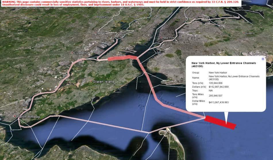
34 CPT and Navigation Systems New York Harbor: budgeted as separate navigation projects yet functions as a navigation system. Hudson River: 14.2M tons, 2009 East River: 24.3M tons, 2009 Newark Bay: 39.5M tons, 2009 NY-NJ Channels (Arthur KillKill van Kull): 121.0M tons, 2009 Buttermilk Channel: 23.8M tons, 2009 Total tonnage: 148M New York Lower Entrance Channels: 135.4M tons, 2009 CPT is helping to ensure that Project O&M budgeting considers channel depthutilization, cargo types, and system interdependencies (i.e. condition of other projects!). 34

35 Quantifying Impacts of Shoaling Great Lakes coal and iron ore Disruptions due to 5-ft shoaling Miss and Columbia Rivers grain exports Coal terminals; e.g. Mobile, Norfolk Scalable approach for quickly estimating cargo that must be lightloaded due to shoaling conditions. Slopes of trend lines indicate the average amount of cargo that must be removed from each vessel in order to reduce vessel draft by 1-ft. 4,500 tons/vessel/ft of depth Approach can be extended to total annual cargo disruptions, number of required additional voyages, and ultimately increased shipping costs. Tons/vessel Tons per vessel vs. draft y = x R 2 = y = x R 2 = y = x R 2 = Draft (ft) 35


36 Coastal Structures Management, Analysis, and Ranking Tool (CSMART) What is CSMART? Web-based, Silverlight application that prioritizes coastal structures according to user-specified criteria and weightings on metrics such as condition rating, commercial tonnage, fish landings, and cruise and ferry passengers. Allows local, regional, and national queries and comparisons
 37")
37 Structure Prioritization via CSMART Structure rankings depend upon user-specified criteria: District Total Combined Annual Condition Tonnage-DCR Ratings (50/50) 37


")

 Ebb Shoal 0.")

38 Geomorphologic Webtools seamless connecting data with models and online tools Inlets Online Berms Online Federal Inlets Database Offshore 0.1 V Oe=1,000,000,000 m 3 Inlets and Berms Online Databases to Common Web Platform Geomorphic Properties of Inlets (Hayes Diagram Reform; Ebb Shoal Dimensions) Define areas of influence of inlets Berms Online Database Nearshore Berm Calculator Inlet Reservoir Model (Web Version) Nearshore Berm Calculator Inlet Reservoir Model (Web-based Version) Ebb Shoal 0.7 Flood Shoal V Ce= 200,000 m 3 V Ee= 2,000,000 m Channel c V Fe=200,000 m 3 Bay Deposition Basin 0.3 V ce,v De,V Ee,V Fe,V ye,v Oe
39 FY12 Nearshore Berms Questions Placement Method: Pump vs. Hopper Dredge Quantity and Rigor of Design: Dumped vs. Designed Cross-shore Location: Feed sand vs. wave break Alongshore Location: Relative to inlet; gaps required? Environmental Concerns: Dispersion of fines over habitat Onshore Migration 39
")


 Pre-project site characterization")
40 FY12 Nearshore Berms Products Ft. Myers Berm (Completed; Final Report Pending) Sediment dispersion Bathymetric change and berm migration rates Pensacola Berm (In Monitoring Phase) Sediment dispersion Alongshore migration rates Pensacola channel infilling rates Egmont Berm (In Monitoring Phase) Pre-project site characterization Post-placement evolution 40

 and volume Placement position in crossshore,")

41 FY12 Nearshore Berms Berms Online: A Nearshore Berm Historical Database Simple Planning Calculator Tool Developing flexible tools (rapid desk-top to detailed models) for design Dredged sediment size(s) and volume Placement position in crossshore, and soon in alongshore Site processes represented through empirical formulae Guideline Development Check out the Berm Booth! 41

42 CIRP Future 42

, CPT Smart Phone App Models and")


43 CIRP Vision for O&M Decision-Support Advance R&D in models and tools Examples Channel Portfolio Tool (CPT), CPT Smart Phone App Models and Tools Link to existing data and databases link Produce accurate calculations with quantified goodness-of-fit Other Models and Tools Roll up calculations to speed interpretation Generate graphical and quantitative output for decision-support Speed delivery of results to customers Please let us know if you have more ideas! Models and Tools Offshore Ebb Shoal 0.7 V Ce= 200,000 m 3 V Ee= 2,000,000 m Channel c Deposition Basin V Oe=1,000,000,000 m link Existing Data cirp.usace.army.mil GenCade + SLC V ce,v De,V Ee,V Fe,V ye,v Oe Flood Shoal 0.9 V Fe=200,000 m 3 Bay CIRP Website 43


44 Field Data at Degraded Jetty/Breakwater Decision-support guidance for rehab given damage rate & SLC Many federal structures 50+ years old Validate wave overtopping, transmission, and sand transport through rubblemound structures Rehabilitation multi-million $ Consider archived AIS vessel movement; is wave transmission through jetties creating navigation hazards? 44
45 CIRP Existing and Future SoNs Presently Addressing 5 SoNs: 45
:")
46 CIRP Existing and Future SoNs Propose Adding 4 More in FY13 (discuss Thu): 46


47 Thank you! Ned, Mary Beth, David, and baby John Mitchell 47
Evaluation of Placement Alternatives for Matagorda Ship Channel Bottleneck Removal
 Evaluation of Placement Alternatives for Matagorda Ship Channel Bottleneck Removal James Rosati III Ashley E. Frey CPT Grays Harbor, WA Wood Wood chips Flour Other CMS Shark River Inlet, NJ US Army Corps
Figure 1 Example feature overview.
 1. Introduction This case focuses on the northeastern region of Onslow Bay, NC, and includes an initial shoreline, regional contour, wave gauges, inlets, dredging, and beach fills. Most of the features
Tanya M. Beck. Kelly Legault. Research Physical Scientist Coastal & Hydraulics Lab, ERDC Vicksburg, MS
 Inlet And Adjacent Shoreline Processes at Cascading Time Scales Using the Coastal Modeling System and GenCade Tanya M. Beck Research Physical Scientist Coastal & Hydraulics Lab, ERDC Vicksburg, MS Kelly
CROSS-SHORE SEDIMENT PROCESSES
 The University of the West Indies Organization of American States PROFESSIONAL DEVELOPMENT PROGRAMME: COASTAL INFRASTRUCTURE DESIGN, CONSTRUCTION AND MAINTENANCE A COURSE IN COASTAL DEFENSE SYSTEMS I CHAPTER
A Modeling Study of Coastal Sediment Transport and Morphology Change
 A Modeling Study of Coastal Sediment Transport and Morphology Change Honghai Li 1, Alejandro Sanchez 1, Mitchell E. Brown 1, Irene M. Watts 2, Zeki Demirbilek 1, Julie D. Rosati 1, and David R. Michalsen
Nearshore Dredged Material Placement Pilot Study at Noyo Harbor, CA
 1 Nearshore Dredged Material Placement Pilot Study at Noyo Harbor, CA Noyo Cove N 2011 National Conference on Beach Preservation Technology 9-11, February 2011 Lihwa Lin, Honghai Li, Mitchell Brown US
Inlet Management Study for Pass-A-Grille and Bunces Pass, Pinellas County, Florida
 Inlet Management Study for Pass-A-Grille and Bunces Pass, Pinellas County, Florida Final Report Submitted By Ping Wang, Ph.D., Jun Cheng Ph.D., Zachary Westfall, and Mathieu Vallee Coastal Research Laboratory
Mouth of the Columbia River Jetties Three-Phase Construction Plan
 Mouth of the Columbia River Jetties Three-Phase Construction Plan Project Overview October 9, 2012 US Army Corps of Engineers MCR Jetties Major Rehabilitation Sand Island pile dikes 1930-1935 Columbia
Assateague Island National Seashore North End Restoration Project Timeline
 Assateague Island National Seashore North End Restoration Project Timeline Date Event Some information provided in the Project Introduction document. Detailed events are available in a timeline compiled
Effect of Hydrodynamics on Sediment Transport near a Coastal Inlet
 ICHE 2014, Hamburg - Lehfeldt & Kopmann (eds) - 2014 Bundesanstalt für Wasserbau ISBN 978-3-939230-32-8 Effect of Hydrodynamics on Sediment Transport near a Coastal Inlet H. Li, M. Brown, J. Rosati & Z.
Coastal Sediment Transport Modeling Ocean Beach & San Francisco Bight, CA
 1 Coastal Sediment Transport Modeling Ocean Beach & San Francisco Bight, CA Honghai Li and Lihwa Lin Engineering Research and Development Center U.S. Army Corps of Engineers Frank Wu, Lisa Andes, and James
GenCade Applications Ashley Frey
 GenCade Applications Ashley Frey Research Civil Engineer, Co-PI of the Inlet Engineering Toolbox work unit of CIRP Report Documentation Page Form Approved OMB No. 0704-0188 Public reporting burden for
Passage Key Inlet, Florida; CMS Modeling and Borrow Site Impact Analysis
 Passage Key Inlet, Florida; CMS Modeling and Borrow Site Impact Analysis by Kelly R. Legault and Sirisha Rayaprolu PURPOSE: This Coastal and Hydraulics Engineering Technical Note (CHETN) describes the
Chapter 4 EM THE COASTAL ENGINEERING MANUAL (Part I) 1 August 2008 (Change 2) Table of Contents. Page. I-4-1. Background...
 1 August 2008 (Change 2) Table of Contents. Page. I-4-1. Background...") Chapter 4 EM 1110-2-1100 THE COASTAL ENGINEERING MANUAL (Part I) 1 August 2008 (Change 2) Table of Contents I-4-1. Background... Page I-4-1 a. Shore Protection Planning and Design, TR 4... I-4-1 b. Shore
Chapter 4 EM 1110-2-1100 THE COASTAL ENGINEERING MANUAL (Part I) 1 August 2008 (Change 2) Table of Contents I-4-1. Background... Page I-4-1 a. Shore Protection Planning and Design, TR 4... I-4-1 b. Shore
EVALUATION OF BEACH EROSION UP-DRIFT OF TIDAL INLETS IN SOUTHWEST AND CENTRAL FLORIDA, USA. Mohamed A. Dabees 1 and Brett D.
 EVALUATION OF BEACH EROSION UP-DRIFT OF TIDAL INLETS IN SOUTHWEST AND CENTRAL FLORIDA, USA Mohamed A. Dabees 1 and Brett D. Moore 1 The paper discusses the analysis of up-drift beach erosion near selected
MIKE Release General product news for Marine software products, tools & features. Nov 2018
 MIKE Release 2019 General product news for Marine software products, tools & features Nov 2018 DHI 2012 MIKE 3 Wave FM New advanced phase-resolving 3D wave modelling product A MIKE 3 FM Wave model - why?
MOREHEAD CITY HARBOR, NC. Dredged Material Management Plan (DMMP)
") MOREHEAD CITY HARBOR, NC Dredged Material Management Plan (DMMP) Public Meeting/Info Session 15 January 2014 US Army Corps of Engineers Morehead City Harbor DMMP Presentation Topics Morehead City Harbor
MOREHEAD CITY HARBOR, NC Dredged Material Management Plan (DMMP) Public Meeting/Info Session 15 January 2014 US Army Corps of Engineers Morehead City Harbor DMMP Presentation Topics Morehead City Harbor
New Jersey Coastal Zone Overview. The New Jersey Beach Profile Network (NJBPN) 3 Dimensional Assessments. Quantifying Shoreline Migration
 3 Dimensional Assessments. Quantifying Shoreline Migration") New Jersey Coastal Zone Overview The New Jersey Beach Profile Network (NJBPN) Objectives Profile Locations Data Collection Analyzing NJBPN Data Examples 3 Dimensional Assessments Methodology Examples Quantifying
New Jersey Coastal Zone Overview The New Jersey Beach Profile Network (NJBPN) Objectives Profile Locations Data Collection Analyzing NJBPN Data Examples 3 Dimensional Assessments Methodology Examples Quantifying
Coastal Modeling System: Dredging Module
 Coastal Modeling System: Dredging Module by Chris Reed and Alejandro Sánchez PURPOSE: This Coastal and Hydraulics Engineering Technical Note (CHETN) describes the implementation of a dredging module (DM)
ABSTRACT. KEY WORDS: Navigation safety; numerical modeling; waves; current; sediment transport; channel infilling; morphology change.
 The 25th (2015) International Polar and Engineering Conference Li, H., L. Lin, Z. Demirbilek, T. M. Beck, and H. R. Moritz (2015). Wave-Current Conditions and Navigation Safety at an Inlet Entrance. The
HURRICANE SANDY LIMITED REEVALUATION REPORT UNION BEACH, NEW JERSEY DRAFT ENGINEERING APPENDIX SUB APPENDIX D SBEACH MODELING
 HURRICANE SANDY LIMITED REEVALUATION REPORT UNION BEACH, NEW JERSEY DRAFT ENGINEERING APPENDIX SUB APPENDIX D SBEACH MODELING Rev. 18 Feb 2015 1 SBEACH Modeling 1.0 Introduction Following the methodology
FEMA Region V. Great Lakes Coastal Flood Study. Pilot Study Webinar. Berrien County, Michigan. February 26, 2014
 FEMA Region V Great Lakes Coastal Flood Study Pilot Study Webinar Berrien County, Michigan February 26, 2014 2 Pilot Study Webinar Agenda Great Lakes Coastal Flood Study Background Demonstration Project
Appendix E Cat Island Borrow Area Analysis
 Appendix E Cat Island Borrow Area Analysis ERDC/CHL Letter Report 1 Cat Island Borrow Area Analysis Multiple borrow area configurations were considered for Cat Island restoration. Borrow area CI1 is located
NUMERICAL SIMULATION OF SEDIMENT PATHWAYS AT AN IDEALIZED INLET AND EBB SHOAL
 In: Proceedings Coastal Sediments 03. 2003. CD-ROM Published by World Scientific Publishing Corp. and East Meets West Productions, Corpus Christi, Texas, USA. ISBN 981-238-422-7. NUMERICAL SIMULATION OF
Shoreline Change Modeling Using One-Line Models: Application and Comparison of GenCade, Unibest, and Litpack
 Shoreline Change Modeling Using One-Line Models: Application and Comparison of GenCade, Unibest, and Litpack by Kimberly E. Townsend, Robert C. Thomas, and Ashley E. Frey PURPOSE: The purpose of this Coastal
Innovative Technologies for a Resilient Marine Transportation System
 Innovative Technologies for a Resilient Marine Transportation System Transportation Research Board MG John Peabody, P.E. Deputy Commanding General for Civil and Emergency Operations, U.S. Army Corps of
Follets Island Nearshore Beach Nourishment Project
 Coast & Harbor Engineering A division of Hatch Mott MacDonald Follets Island Nearshore Beach Nourishment Project Arpit Agarwal, P.E. April 1, 2016 Project Site!"#$% &'(% &)*+% )#,'-+% Shoreline Erosion
Sediment Transport Analysis Village of Asharoken, New York
 Sediment Transport Analysis Village of Asharoken, New York NORTH SHORE OF LONG ISLAND, NEW YORK COMBINED EROSION CONTROL AND STORM DAMAGE PROTECTION FEASIBILITY STUDY FINAL REPORT August 2004 Cell 0 Asharoken
Kelly Legault, Ph.D., P.E. USACE SAJ
 Kelly Legault, Ph.D., P.E. USACE SAJ Report Documentation Page Form Approved OMB No. 0704-0188 Public reporting burden for the collection of information is estimated to average 1 hour per response, including
Volume and Shoreline Changes along Pinellas County Beaches during Tropical Storm Debby
 Volume and Shoreline Changes along Pinellas County Beaches during Tropical Storm Debby Ping Wang and Tiffany M. Roberts Coastal Research Laboratory University of South Florida July 24, 2012 Introduction
Coastal and Hydraulics Laboratory
 ERDC/CHL TR-12-14 Coastal Inlets Research Program St. Johns County, St. Augustine Inlet, FL Report 1: Historical Analysis and Sediment Budget Kelly Legault, Julie D. Rosati, Jason Engle, and Tanya M. Beck
GenCade Application at Onslow Bay, North Carolina
 GenCade Application at Onslow Bay, North Carolina by Ashley E. Frey, Sophie Munger, Greg L. Williams, Michael J. Wutkowski, and Kevin B. Conner PURPOSE: This Coastal and Hydraulics Engineering Technical
GENERAL METHODOLOGY FOR INLET RESERVOIR MODEL ANALYSIS OF SAND MANAGEMENT NEAR TIDAL INLETS. Mohamed A. Dabees 1, Nicholas C.
 GENERAL METHODOLOGY FOR INLET RESERVOIR MODEL ANALYSIS OF SAND MANAGEMENT NEAR TIDAL INLETS Mohamed A. Dabees 1, Nicholas C. Kraus 2 1 Humiston& Moore Engineers, 5679 Strand Court, Naples, FL 34109, USA.
Beach Nourishment Impact on Beach Safety and Surfing in the North Reach of Brevard County, Florida
 Beach Nourishment Impact on Beach Safety and Surfing in the North Reach of Brevard County, Florida Prepared by John Hearin, Ph.D. Coastal Engineering Vice Chairman Cocoa Beach Chapter Port Canaveral Patrick
US Beach Nourishment Experience:
 Beach Nourishment: Introduction of new sand to the beach by truck or dredge Large beach >1 million cubic yards (100,000 dump truck loads) Funding is a combination of federal, state, local & private Also
Coastal and Hydraulics Laboratory
 ERDC/CHL TR-11-2 Coastal Inlets Research Program Analysis of Dredged Material Placement Alternatives for Bottleneck Removal, Matagorda Ship Channel, Texas James Rosati III, Ashley E. Frey, Mitchell E.
Salt Ponds Shore Zone Modeling for Breakwater Placement: Summary Report
 Salt Ponds Shore Zone Modeling for Breakwater Placement: Summary Report Virginia Institute of Marine Science May 2014 Salt Ponds Shore Zone Modeling for Breakwater Placement: Summary Report For Waterway
OECS Regional Engineering Workshop September 29 October 3, 2014
 B E A C H E S. M A R I N A S. D E S I G N. C O N S T R U C T I O N. OECS Regional Engineering Workshop September 29 October 3, 2014 Coastal Erosion and Sea Defense: Introduction to Coastal/Marine Structures
GenCade: Introduction, Background, and Formulation
 GenCade: Introduction, Background, and Formulation Ashley Frey Ashley.E.Frey@usace.army.mil Tanya Beck Tanya.M.Beck@usace.army.mil March 7, 2012 CMS Shark River Inlet, NJ CPT Grays Harbor, WA Wood Wood
First Year Morphological Evolution of an Artificial Berm at Fort Myers Beach, Florida
 University of South Florida Scholar Commons Geology Faculty Publications Geology 1-2012 First Year Morphological Evolution of an Artificial Berm at Fort Myers Beach, Florida Katherine Brutsche University
Response of a Newly Created Marsh-Wetland Affected by Tidal Forcing, Upland Discharge, and Groundwater Interaction
 Response of a Newly Created Marsh-Wetland Affected by Tidal Forcing, Upland Discharge, and Groundwater Interaction Mouth of Columbia River, Cape Disappointment State Park, Washington 12 Hans R. Moritz
Implementation of Structures in the CMS: Part IV, Tide Gate
 Implementation of Structures in the CMS: Part IV, Tide Gate by Honghai Li, Alejandro Sanchez, and Weiming Wu PURPOSE: This Coastal and Hydraulics Engineering Technical Note (CHETN) describes the mathematical
IMPACTS OF COASTAL PROTECTION STRATEGIES ON THE COASTS OF CRETE: NUMERICAL EXPERIMENTS
 IMPACTS OF COASTAL PROTECTION STRATEGIES ON THE COASTS OF CRETE: NUMERICAL EXPERIMENTS Tsanis, I.K., Saied, U.M., Valavanis V. Department of Environmental Engineering, Technical University of Crete, Chania,
Pathways Interns: Annika O Dea, Ian Conery, Andrea Albright
 1 REMOTE SENSING OF COASTAL MORPHODYNAMICS 237 237 237 217 217 217 2 2 2 8 119 27 252 174.59 255 255 255 163 163 163 131 132 122 239 65 53 11 135 12 112 92 56 62 12 13 12 56 48 13 12 111 Kate Brodie Brittany
Analysis of Packery Channel Public Access Boat Ramp Shoreline Failure
 Journal of Coastal Research SI 59 150-155 West Palm Beach, Florida 2011 Analysis of Packery Channel Public Access Boat Ramp Shoreline Failure Christopher W. Reed and Lihwa Lin URS Corporation 1625 Summit
Comparisons of Physical and Numerical Model Wave Predictions with Prototype Data at Morro Bay Harbor Entrance, California
 Comparisons of Physical and Numerical Model Wave Predictions with Prototype Data at Morro Bay Harbor Entrance, California by Robert R. Bottin, Jr. and Edward F. Thompson PURPOSE: This Coastal and Hydraulics
Impact of Dredging the Lower Narrow River on Circulation and Flushing
 Impact of Dredging the Lower Narrow River on Circulation and Flushing Craig Swanson Ph.D. Swanson Environmental Alex Shaw Ocean Engineering, URI Prof. Malcolm L. Spaulding Ocean Engineering, URI 29 January
CALCASIEU SALINITY STRUCTURES. HYDRODYNAMIC MODELING (To Support Design of Salinity Barriers)
") CALCASIEU SALINITY STRUCTURES HYDRODYNAMIC MODELING (To Support Design of Salinity Barriers) Presentation Overview 1 2 3 4 5 Project Overview and CEA Circulation Modeling Vessel Hydrodynamics Modeling
CALCASIEU SALINITY STRUCTURES HYDRODYNAMIC MODELING (To Support Design of Salinity Barriers) Presentation Overview 1 2 3 4 5 Project Overview and CEA Circulation Modeling Vessel Hydrodynamics Modeling
The construction of Deepwater Navigation Channel (DNC) in the Bystry arm of the Danube Delta has started in The whole project provides the
 in the Bystry arm of the Danube Delta has started in The whole project provides the") Annex 45 Numerical Studies of Waves, Currents and Sediment Transport at the Marine Part of Deepwater Navigation Channel through the Bystry Arm of the Danube Delta and Model Verification based on Laboratory
Annex 45 Numerical Studies of Waves, Currents and Sediment Transport at the Marine Part of Deepwater Navigation Channel through the Bystry Arm of the Danube Delta and Model Verification based on Laboratory
Advanced Series on Ocean Engineering - Volume 14 COASTAL STABILIZATION. Richard Silvester John R C Hsu. \v? World Scientific
 Advanced Series on Ocean Engineering - Volume 14 COASTAL STABILIZATION Richard Silvester John R C Hsu \v? World Scientific Contents PREFACE xv 1 INTRODUCTION 1 /. / Coastal Environment 2 J.2 State of Beach
Coastal and Hydraulics Laboratory. Verification and Validation of the Coastal Modeling System ERDC/CHL TR Report 1: Summary Report
 ERDC/CHL TR-11-10 Verification and Validation of the Coastal Modeling System Report 1: Summary Report Zeki Demirbilek and Julie Rosati December 2011 Coastal and Hydraulics Laboratory Approved for public
Strategic Placement an EWN/RSM Solution to Dredged Material Management
 Strategic Placement an EWN/RSM Solution to Dredged Material Management EWN/RSM IPR, Vicksburg, MS 22 July 2014 Joseph Z. Gailani Cheryl E. Pollock Definitions EWN: The intentional alignment of natural
Techniques for Measuring and Analyzing Inlet Ebb-Shoal Evolution
 US Army Corps of Engineers Coastal Engineering Technical Note IV-13 Techniques for Measuring and Analyzing Inlet Ebb-Shoal Evolution by Donald K. Stauble PURPOSE: The Coastal Engineering Technical Note
CMS Modeling of the North Coast of Puerto Rico
 CMS Modeling of the North Coast of Puerto Rico PRESENTED BY: Dr. Kelly Rankin Legault, Ph.D., P.E. 1 Dr. Alfredo Torruella, Ph.D. 2 1 USACE Jacksonville District 2 University of Puerto Rico October 2016
Atlantic Coast of Long Island, Jones Inlet to East Rockaway Inlet, Long Beach Island, NY Construction Update
 Atlantic Coast of Long Island, Jones Inlet to East Rockaway Inlet, Long Beach Island, NY Construction Update June 2016 US Army Corps of Engineers Project Purpose Three specific damage mechanisms of coastal
North Shore of Long Island, Feasibility Study
 North Shore of Long Island, Asharoken New York Asharoken, Feasibility Study Asharoken, NY Public Meeting June 30, 2015 US Army Corps of Engineers US Army Corps of Engineers New York BUILDING STRONG BUILDING
Southwest Washington Littoral Drift Restoration Project: Design, Construction, and Monitoring
 Southwest Washington Littoral Drift Restoration Project: Design, Construction, and Monitoring J Jessica i St Stokke kk USACE Portland District October 28, 2010 WEDA Pacific Meeting Monterey, CA US Army
Evaluation of June 9, 2014 Federal Emergency Management Agency Flood Insurance Study for Town of Weymouth, Norfolk, Co, MA
 Evaluation of June 9, 2014 Federal Emergency Management Agency Flood Insurance Study for Town of Weymouth, Norfolk, Co, MA Prepared For: Woodard & Curran 95 Cedar Street, Suite 100 Providence, RI 02903
Town of Duck, North Carolina
 Tracking No. 00.00.2010 Erosion Mitigation And Shoreline Management Feasibility Study Town of Duck, North Carolina Coastal Planning & Engineering of North Carolina August 15, 2012 Tom Jarrett Robert Neal
COASTAL EVOLUTION MODELING AT MULTIPLE SCALES IN REGIONAL SEDIMENT MANAGEMENT APPLICATIONS
 1920 COASTAL EVOLUTION MODELING AT MULTIPLE SCALES IN REGIONAL SEDIMENT MANAGEMENT APPLICATIONS HANS HANSON 1, KENNETH J. CONNELL 2, MAGNUS LARSON 1, NICHOLAS C. KRAUS 3, TANYA M. BECK 3, ASHLEY E. FREY
U.S. Army Corps of Engineers Navigation Fiscal Overview
 U.S. Army Corps of Engineers Navigation Fiscal Overview National Dredging Meeting Jeffrey A. McKee Chief, Navigation Branch US Army Corps of Engineers June 24-26, 2014 US Army Corps of Engineers 1 Corps
Shoreline Evolution Due to Oblique Waves in Presence of Submerged Breakwaters. Nima Zakeri (Corresponding Author), Mojtaba Tajziehchi
, Mojtaba Tajziehchi") Shoreline Evolution Due to Oblique Waves in Presence of Submerged Breakwaters Nima Zakeri (Corresponding Author), Mojtaba Tajziehchi Department of Civil Engineering, Faculty of Engineering, University
Shoreline Evolution Due to Oblique Waves in Presence of Submerged Breakwaters Nima Zakeri (Corresponding Author), Mojtaba Tajziehchi Department of Civil Engineering, Faculty of Engineering, University
Coastal Wave Studies FY13 Summary Report
 DISTRIBUTION STATEMENT A. Approved for public release; distribution is unlimited. Coastal Wave Studies FY13 Summary Report Jeffrey L. Hanson US Army Corps of Engineers, Field Research Facility 1261 Duck
Comparison of Predicted and Measured Shoaling at Morro Bay Harbor Entrance, California
 Comparison of Predicted and Measured Shoaling at Morro Bay Harbor Entrance, California by Edward F. Thompson, Inocencio P. DiRamos, and Robert R. Bottin, Jr. PURPOSE: This Coastal and Hydraulics Engineering
CRC Inlet Management Study. Matt Slagel Shoreline Management Specialist
 CRC Inlet Management Study Matt Slagel Shoreline Management Specialist Study Origin CRC shall study feasibility of creating new AEC for lands adjacent to mouth of Cape Fear River (HB 819) Collaborate with
DUXBURY WAVE MODELING STUDY
 DUXBURY WAVE MODELING STUDY 2008 Status Report Duncan M. FitzGerald Peter S. Rosen Boston University Northeaster University Boston, MA 02215 Boston, MA 02115 Submitted to: DUXBURY BEACH RESERVATION November
FEDERAL INLETS DATABASE
 To appear: Proceedings 2002 National Conference on Beach Preservation Technology, FSBPA. FEDERAL INLETS DATABASE Erica Eva Carr 1 and Nicholas C. Kraus 2 Abstract: The U.S. Army Corps of Engineers Coastal
Development and Implementation of a Relocatable Coastal and Nearshore Modeling System
 Development and Implementation of a Relocatable Coastal and Nearshore Modeling System James M. Kaihatu Zachry Department of Civil Engineering, Texas A&M University 3136 TAMU College Station, TX 77843-3136
Inner-Bank Erosion Processes and Solutions at Coastal Inlets
 Inner-Bank Erosion Processes and Solutions at Coastal Inlets by William C. Seabergh PURPOSE: The Coastal and Hydraulics Engineering Technical Note (CHETN) herein provides information on erosion which occurs
Reservoir Model for Calculating Natural Sand Bypassing and Change in Volume of Ebb-Tidal Shoals, Part I: Description
 Reservoir Model for Calculating Natural Sand Bypassing and Change in olume of Ebb-Tidal Shoals, Part I: Description by Nicholas C. Kraus PURPOSE: The Coastal and Hydraulics Engineering Technical Note (CHETN)
CHAPTER 134 INTRODUCTION
 CHAPTER 134 NEW JETTIES FOR TUNG-KANG FISHING HARBOR, TAIWAN Chi-Fu Su Manager Engineering Department Taiwan Fisheries Consultants, Inc. Taipei, Taiwan INTRODUCTION Tung-Kang Fishing Harbor, which is about
Planning Considerations for Nearshore Placement of Mixed Dredged Sediments
 Planning Considerations for Nearshore Placement of Mixed Dredged Sediments PURPOSE: Dredging planning and management decisions are based on a combination of engineering and economic factors tempered by
TRANSPORT OF NEARSHORE DREDGE MATERIAL BERMS
 Proceedings of the 6 th International Conference on the Application of Physical Modelling in Coastal and Port Engineering and Science (Coastlab16) Ottawa, Canada, May 10-13, 2016 Copyright : Creative Commons
OECS Regional Engineering Workshop September 29 October 3, 2014
 B E A C H E S. M A R I N A S. D E S I G N. C O N S T R U C T I O N. OECS Regional Engineering Workshop September 29 October 3, 2014 Coastal Erosion and Sea Defense: Introduction to Coastal Dynamics David
LITTLE LAGOON & LITTLE LAGOON PASS: RESEARCH UPDATES & DIRECTIONS
 LITTLE LAGOON & LITTLE LAGOON PASS: RESEARCH UPDATES & DIRECTIONS Bret M. Webb, PhD, PE, DCE Professor Department of Civil, Coastal, and Environmental Engineering October 19, 2017 LLPS Meeting Acknowledgments
INTRODUCTION TO COASTAL ENGINEERING AND MANAGEMENT
 Advanced Series on Ocean Engineering Volume 16 INTRODUCTION TO COASTAL ENGINEERING AND MANAGEMENT J. William Kamphuis Queen's University, Canada World Scientific Singapore New Jersey London Hong Kong Contents
Appendix G Applied Coastal Pipeline Impact Assessment
 Appendix G Applied Coastal Pipeline Impact Assessment Simulating the Potential Impact of Borrow Site Excavation on Sediment Transport Along the Gulfstream Pipeline, Petit Bois Pass, Alabama Prepared for:
APPENDIX M DREDGED MATERIAL MANAGEMENT PLAN (DMMP) FINAL INTEGRATED FEASIBILITY REPORT AND ENVIRONMENTAL ASSESSMENT
 FINAL INTEGRATED FEASIBILITY REPORT AND ENVIRONMENTAL ASSESSMENT") APPENDIX M DREDGED MATERIAL MANAGEMENT PLAN (DMMP) Brazos Island Harbor, Texas Channel Improvement Study FINAL INTEGRATED FEASIBILITY REPORT AND ENVIRONMENTAL ASSESSMENT This page is intentionally left
APPENDIX M DREDGED MATERIAL MANAGEMENT PLAN (DMMP) Brazos Island Harbor, Texas Channel Improvement Study FINAL INTEGRATED FEASIBILITY REPORT AND ENVIRONMENTAL ASSESSMENT This page is intentionally left
Compiled by Uwe Dornbusch. Edited by Cherith Moses
 REPORT ON WAVE AND TIDE MEASUREMENTS Compiled by Uwe Dornbusch. Edited by Cherith Moses 1 Aims...1 2 Summary...1 3 Introduction...1 4 Site selection...1 5 Wave recorder settings...2 6 Results...2 6.1 Water
Oceans and Coasts. Chapter 18
 Oceans and Coasts Chapter 18 Exploring the oceans The ocean floor Sediments thicken and the age of the seafloor increases from ridge to shore The continental shelf off the northeast United States Constituent
Wave Transformation, Prediction, and Analysis at Kaumalapau Harbor, Lanai, Hawaii
 Wave Transformation, Prediction, and Analysis at Kaumalapau Harbor, Lanai, Hawaii Jessica H. Podoski, P.E. Coastal Engineer, USACE Honolulu District Christopher Goody, P.E. Sea Engineering, Inc. Thomas
INTRODUCTION TO COASTAL ENGINEERING
 The University of the West Indies Organization of American States PROFESSIONAL DEVELOPMENT PROGRAMME: COASTAL INFRASTRUCTURE DESIGN, CONSTRUCTION AND MAINTENANCE A COURSE IN COASTAL DEFENSE SYSTEMS I CHAPTER
Coastal and Hydraulics Laboratory
 ERDC/CHL TR-17-13 Regional Sediment Management (RSM) Program Sediment Budget Analysis; Masonboro Inlet, North Carolina Kevin B. Conner and Linda S. Lillycrop August 2017 Coastal and Hydraulics Laboratory
CHAPTER 8 ASSESSMENT OF COASTAL VULNERABILITY INDEX
 124 CHAPTER 8 ASSESSMENT OF COASTAL VULNERABILITY INDEX 8.1 INTRODUCTION In order to assess the vulnerability of the shoreline considered under this study against the changing environmental conditions,
Ongoing Research at the USACE Field Research Facility Jeff Waters, PhD Chief, Coastal Observations & Analysis Branch Coastal & Hydraulics Lab
 Ongoing Research at the USACE Field Research Facility Jeff Waters, PhD Chief, Coastal Observations & Analysis Branch Coastal & Hydraulics Lab Coastal and Hydraulics Laboratory Who We Are CHL is the only
Grays Harbor O&M and Deepening Dredging
 Grays Harbor O&M and Deepening Dredging Elizabeth Chien Project Manager Seattle District 28 January 2016 US Army Corps of Engineers Grays Harbor Navigation Channel Inner Harbor O&M Dredging Summer 2015:
Nearshore Placed Mound Physical Model Experiment
 Nearshore Placed Mound Physical Model Experiment PURPOSE: This technical note describes the migration and dispersion of a nearshore mound subjected to waves in a physical model. The summary includes recommendations
100-YEARS OF SHOAL EVOLUTION AT THE MOUTH OF THE COLUMBIA RIVER: IMPACTS ON CHANNEL, STRUCTURES, AND SHORELINES
 100-YEARS OF SHOAL EVOLUTION AT THE MOUTH OF THE COLUMBIA RIVER: IMPACTS ON CHANNEL, STRUCTURES, AND SHORELINES Hans R. Moritz, 1 Heidi P. Moritz, 2 Jessica R. Hays, 3 and Heather R. Sumerell 4 Abstract:
Long Beach Island Holgate Spit Little Egg Inlet Historical Evolution Introduction Longshore Transport Map, Survey and Photo Historic Sequence
 Appendix B Long Beach Island Holgate Spit Little Egg Inlet Historical Evolution Introduction The undeveloped southern end of Long Beach Island (LBI) is referred to as the Holgate spit as it adjoins the
Dune Monitoring Data Update Summary: 2013
 Dune Monitoring Data Update Summary: 13 Shoreline Studies Program Virginia Institute of Marine Science College of William & Mary Gloucester Point, Virginia September 13 Dune Monitoring Data Update Summary:
Natural Mechanisms of Sediment Bypassing at Tidal Inlets
 Natural Mechanisms of Sediment Bypassing at Tidal Inlets by D. M. FitzGerald, N. C. Kraus, and E. B. Hands PURPOSE: The Coastal and Hydraulics Engineering Technical Note (CHETN) described herein describes
Chapter. The Dynamic Ocean
 Chapter The Dynamic Ocean An ocean current is the mass of ocean water that flows from one place to another. 16.1 The Composition of Seawater Surface Circulation Surface Currents Surface currents are movements
CHAPTER 281 INFLUENCE OF NEARSHORE HARDBOTTOM ON REGIONAL SEDIMENT TRANSPORT
 CHAPTER 281 INFLUENCE OF NEARSHORE HARDBOTTOM ON REGIONAL SEDIMENT TRANSPORT Paul C.-P. Lin, Ph.D., P.E. 1 and R. Harvey Sasso, P.E. 2 ABSTRACT The influence of nearshore hardbottom on longshore and cross-shore
Morphological Evolution Near an Inlet
 DISTRIBUTION STATEMENT A. Approved for public release; distribution is unlimited. Morphological Evolution Near an Inlet Steve Elgar Woods Hole Oceanographic Institution, MS11 Woods Hole, MA 02543 phone:
FINAL ENVIRONMENTAL IMPACT STATEMENT ON BROWARD COUNTY SHORE PROTECTION PROJECT SEGMENTS II AND III BROWARD COUNTY, FLORIDA
 FINAL ENVIRONMENTAL IMPACT STATEMENT ON BROWARD COUNTY SHORE PROTECTION PROJECT SEGMENTS II AND III BROWARD COUNTY, FLORIDA 1. PROJECT PURPOSE AND NEED 1.1. PROJECT AUTHORITY. 1.1.1. INITIAL AUTHORIZATION.
2016 NC Coastal Local Governments Annual Meeting
 2016 NC Coastal Local Governments Annual Meeting Coastal Flood Study Modeling and Mapping 101 April 21, 2016 Tom Langan, PE, CFM Engineering Supervisor NCEM Floodplain Mapping Program FEMA Coastal Flood
CLAM PASS RESTORATION AND MANAGEMENT PLAN BATHYMETRIC MONITORING REPORT NO. 7 Including Interior Bay Dredge Cuts and Tidal Data
 CLAM PASS RESTORATION AND MANAGEMENT PLAN BATHYMETRIC MONITORING REPORT NO. 7 Including Interior Bay Dredge Cuts and Tidal Data Submitted to: Florida Department of Environmental Protection DEP File No.
KEYNOTE PRESENTATION FSBPA olsen
 AMELIA ISAND, FLORIDA BEACH MANAGEMENT PARTNERING AND PERSERVERENCE Erik Olsen, PE associates, inc. KEYNOTE PRESENTATION FSBPA 2009 IN ORDER TO ADDRESS SHORE PROTECTION TODAY LOCAL INTERESTS PARTNER WITH:
UPPER BEACH REPLENISHMENT PROJECT RELATED
 ASSESSMENT OF SAND VOLUME LOSS at the TOWNSHIP of UPPER BEACH REPLENISHMENT PROJECT RELATED to the LANDFALL OF HURRICANE SANDY - PURSUANT TO NJ-DR 4086 This assessment is in response to Hurricane Sandy
Regular Workshop October 20, 2014 Agenda Item: Dr. Albert E. Browder, PE; Olsen Associates, Inc.
 Regular Workshop October 20, 2014 Agenda Item 8 Agenda Item: Presenter: Summary: Beach Update Town Manager; Dr. Albert E. Browder, PE; Olsen Associates, Inc. At the January 21, 2014 Regular Workshop Meeting,