A COMPARISON OF EVIDENCE BETWEEN TWO LANDING SITE THEORIES
|
|
|
- Priscilla Daniel
- 5 years ago
- Views:
Transcription

1 A COMPARISON OF EVIDENCE BETWEEN TWO LANDING SITE THEORIES I ve always preferred to let the evidence of my cove location hypothesis speak for itself. I would like to address, however, the long-held theory that Francis Drake and his crew landed, camped, and careened their ship, The Golden Hinde for 36 days at Drakes Estero at Drakes Bay. The Drakes Bay site now has a plaque describing its recent federal recognition as the most probable area where Francis Drake landed. Many people believe that it is the cove area where the first European visitors first set foot in northern California. I would like to now make a direct comparison between that recognized site and my hypothesis of Strawberry Cove in San Francisco Bay, using the Hondius Portus Plan map, accepted facts from Drake s journal records and a general overview using logic, and practicality as well as visual and historic knowledge of the area. The Documents Most Commonly Referenced The Famous Voyage of Sir Francis Drake into the South sea, and there hence about the whole Globe of the earth in the yeere of our Lord, 1577, and The World Encompassed According to accepted historical fact, the main ship s journal that was aboard on the Golden Hinde s great voyage was confiscated by Queen Elizabeth I upon the ships return to England in The crew was forbidden to discuss in public the almost-3-year journey and there s little doubt that what eventually was published was highly edited. Journalist Richard Hakluyt later assembled a manuscript that was published in The original in the British Museum was inserted in a copy of Richard Hakluyt s 1589, The Principal Navigations, Voyages and Discoveries of the English Nation, London. The writings were compiled by Hakluyt from three sources John Cooke s manuscript; part of the Anonymous Narrative, and part of the manuscript of Francis Fletcher, the chaplain on Drake s ship. The manuscript is not as comprehensive as the later 1628 publication, The World Encompassed by Sir Francis Drake, which reportedly used more of Fletcher s manuscript, and included more details about the voyage. Other pieces of information were also gathered over time through additional sources, including the Spanish interrogation of Drake s own nephew, John Drake and others.


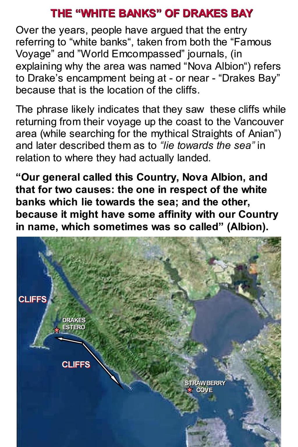
2 Let s compare both sites to the Portus Plan map that was overseen by Drake and later printed as an insert in the Hondius Broadside Map of Drake s voyage of circumnavigation: The Portus Plan map of Drake s California landing site is found at the top-left portion of the Hondius Broadside Map. Let s first look at a comparison with the Drakes Estero site: DRAKES ESTERO COMPARISONS WITH THE PORTUS PLAN MAP
,")

3 The first obvious problem with comparing the Portus Plan map to the Drakes Estero site is that there is an assumption that the Drake map is upside down (showing up as south). While discussing our cove location theories, the late Ed Von der Porten, former President of the Drake Navigators Guild (who supported the Drakes Estero at Drakes Bay location for over 60 years), pointed out to me that there are a few maps from that period that show south as up. I have found it to be extremely rare, and, importantly, all of the rest of the insets, as well as the main global map itself, are traditional in showing north as up. I ve found that Drakes Estero site doen t compare with the Drake map with any real accuracy. The flat island to the left of the Drake map has been explained as a sand spit that disappears and reappears over time. To this day, I ve never seen any real evidence to back up this claim. In addition, much of the cove area at Drakes Estero is well above sea level. Here are a few map comparisons with Strawberry Cove: (MORE PORTUS PLAN STRAWBERRY COVE COMPARISONS ARE BELOW)

4 I ve examined the Drakes Estero site several times (once with a naval scholar) and noticed several problems with this location as a safe, hidden and defendable landing and careening site for the Golden Hinde s stay of 36 days. Here are some of my observations: The approach to the Drakes Estero is neither very wide nor deep. The Golden Hinde s draft, fully laden, was 13 ft. as she would have entered the estero. According to Robert Power, a former President of the California Historical Society and well-known proponent of Drake s landing in San Francisco Bay, the entrance to Drakes Estero had a maximum depth of 13ft, and that Drake would not have hazarded his vessel in entering such a doubtful anchorage. Getting her through the opening of the estero would not be the only challenge. They would have had to line the ship up perfectly at high tide and then ridden a series of small waves into the opening that leads to the Estero. This would be a very risky maneuver and would have put the ship, the crew, and the 40 tons of treasure aboard in danger. Then they would have to fight the current to get the ship to the careening area. It would be another problem to get the ship back out and into the rough bay. There is a strong current that runs out through the estero. The careening of their ship at this proposed location would have been a constant struggle, even for a short stay. Even if they had used several kedge anchors (small land anchors used for the careening process), the ship would have been in the challenging estero for five weeks - a considerably longer time than would have been needed for the repair to the ship s hull. I believe that this would not be the logical physical conditions for such a long stay.


5 Richardson Bay was much deeper before the build-up of silt from logging in the 1800s. Strawberry Cove is calm, hidden and has a natural, deep-channel approach HOW THE LATITUDES MATCH THE JOURNAL DISCRIPTION till we came within 38. degrees towards the line. In which height it pleased God to send vs into a fair and good bay, with a good wind to enter the same. Both of the Drakes Estero and the Strawberry Cove locations are within a half degree, which are well within the margin for error of this reported reading. Drakes Estero is degrees latitude, Strawberry Cove, Both bay entrances are within 38 degrees of the line.

6 The estero is not hidden or defendable. A careened ship and her crew are very vulnerable. Drake was well-aware that Spanish ships may travel up the coast while looking for both him and his ship. The fact that this was typhoon season in the Pacific Ocean would have been noted in the Spanish charts that they knew Drake had taken during his many earlier raids. The Spanish knew that Drake would have to wait somewhere at least a month before departing and sailing west across the Pacific Ocean. On the Portus Plan map, there is a large signal fire illustrated on left side of the map. I believe that the fire/smoke signal would alert the men to an entry of a Spanish ship into The Bay (they used the same system back in England with signal fires on hilltops).this would have put the signal fire right on the beach (that faces south) where the Spanish could have easily seen it. You might as well advertise, I pointed out in one of my conversations with Mr. Von der Porten. Below, I ve illustrated the fire/smoke signal area at both the Drake Estero site and at Strawberry Cove..
 70 men of the crew built a 40 ft.")

7 The Drakes Bay location was visited 16 years after Drake s California landing by Sebastian Cermeno, the Portuguese-born captain of the Manila galleon, San Agustin. The bay proved to be dangerous after a storm ran the ship aground and it was destroyed. In an amazing accomplishment, the (approx.) 70 men of the crew built a 40 ft. boat from the wreckage and sailed all the way to Acapulco, Mexico. Though it was only 16 years after Drake, the men of the San Agustin looked for signs that Drake s encampment had been built there, but found nothing. Notably, the natives of the Drakes Bay area never indicated that they had ever been visited before by Europeans. After Cermeno s disastrous visit, Drakes Bay was never again used as a Manilla Galleon port.


8 THE CARTOGRAPHY: In cartography, the darker the shading, the steeper the shoreline embankment. There are also lines on the land that indicate both hills and height. The Drake map is very consistent with the elevations at Strawberry Cove. Not so with Drakes Estero. For example, if the fire were on a beach, why is it shown with elevation markers and not flat like the other beach area to its left? (Von der Porten said they signified sand dunes). THE STRAWBERRY COVE COMPARISON:


9 ARTEFACTUAL EVIDENCE Locating any artifacts from Drake s stay in Marin has been an elusive endeavor for any and all investigators with a Drake s cove location theory. Many porcelain sherds were found near the Drakes Estero site at Drakes Bay, and Drake most likely had porcelain aboard. The investigation however, of select porcelain sherds as a direct link to Drake by the Drake Navigator s Guild has never been proven without a doubt. In 1595, the ship wreck of the Manila galleon San Austin, captained by Sabastian Cermeno, left most of its cargo at the bottom of Drakes Bay. A Manila galleon would, of course, have large quantities of Chinese porcelain aboard and it is likely that some of it was left on shore. To my knowledge, nothing else of real significance was ever found near Drakes Estero. To date, I have found only decomposed iron at a depth of 6-8ft. at the San Francisco Bay location, however, I contend that there may be at least one major artifact in existence that could relate directly to my Strawberry Cove hypothesis: Though it is still called a hoax by many today who know of its existence, a brass plate, discovered under a rock atop a hill in Greenbrae in 1936, was carefully tested and then confirmed to be the genuine Plate of Brasse, which was referred to in the journals. It was left by Drake as he claimed the area for queen and country as, Nova Albion ( New England ). In the 1970s, a re-examination of the plate led to some doubt, and that doubt was promoted primarily by those who disagreed that Drake had found San Francisco Bay. The plate is still a matter of great debate today. If it is once again examined (see related article, available here on the DISCOVERY page), it may again be determined genuine, making it a possible key piece of artefactual evidence. The plate of brass was discovered about three miles from Strawberry Cove, in a more accessible landing area for larger ships.

10 This artifact was uncovered a short distance from Strawberry Cove (excerpt):
11

12 FINAL NOTE: I had great respect for the knowledge and life s work of the late Edward Von der Porten (former President of the Drake Navigator s Guild). When I first discussed my Drake California landing site hypothesis with him, he staunchly defended his longheld theory that Captain General Francis Drake had careened his ship, the Golden Hinde, in Drakes Estero at Drakes Bay. I was encouraged, however, when he called my site discovery presentation, quite interesting. I ll miss Ed and our many Drake discussions.
VISITING THE DRAKES BAY NATIONAL HISTORIC LANDMARK SITES
 Drake s chaplain, Francis Fletcher reported extensively on the Coast Miwok in his book The World Encompassed. Their feathered baskets, attire, processions, ceremonies, tule balsa boats and more are described
Sebastian Cermeno ( )
") Sebastian Cermeno (1560-1602) Sebastian Rodriguez Cermeno was a Portuguese adventurer who explored the coast of California for Spain. He was a skilled navigator and had lots of experience sailing across
Sebastian Cermeno (1560-1602) Sebastian Rodriguez Cermeno was a Portuguese adventurer who explored the coast of California for Spain. He was a skilled navigator and had lots of experience sailing across
World Explorers. By Sandy Tasker SAMPLE
 Ebook Code REAU 5053 World Explorers By Sandy Tasker Contents How the World Was Discovered... 4 Paths of Exploration... 5 The Vikings 793-1050... 6 Viking Navigation... 7 The Mongols: Early to Mid 1200s...
v.36f, no Circuit Court, S. D. New York. October 15, THE NEWPORT. HATCH ET AL. V. THE NEWPORT, (NEW YORK & C. S. S. CO., CLAIMANT.
 YesWeScan: The FEDERAL REPORTER THE NEWPORT. v.36f, no.14-58 HATCH ET AL. V. THE NEWPORT, (NEW YORK & C. S. S. CO., CLAIMANT.) Circuit Court, S. D. New York. October 15, 1888. COLLISION EVIDENCE SUFFICIENCY
Overview. 70.8% of Earth covered by ocean 97.2% of surface water Interconnected global or world ocean
 Overview 70.8% of Earth covered by ocean 97.2% of surface water Interconnected global or world ocean Principal oceans Pacific Largest, deepest Atlantic Second largest Indian Mainly in Southern Hemisphere
The first man to circumnavigate the world?
 The first man to circumnavigate the world? Born 1480 in Portugal First known expedition: 1505 Sent to India on a mission for the King of Portugal 1513: A Spanish explorer, Balboa, claims to have seen a
Anchoring Is Important
 BCC Sailing Classes - Third Theory Anchoring Anchoring Is Important 1 The Anchor is your last resort. Anchoring Keep off a lee shore. Needs to be shaped (type of anchor) to bury in the type of bottom for
Nautical Chart Challenge
 Discover Your World With NOAA Nautical Chart Challenge For as long as anyone in his family could remember, Francis Beaufort wanted to make scientific observations from the deck of a ship. In 1789 at the
THE DEFEAT OF THE SPANISH ARMADA By GARRETT MATTINGLY
 THE DEFEAT OF THE SPANISH ARMADA By GARRETT MATTINGLY The Defeat of the Spanish Armada by Garrett Mattingley. Full Fathom Five: Wrecks of the Spanish Armada by Colin Martin. The Defeat of the English Armada
Long Beach Island Holgate Spit Little Egg Inlet Historical Evolution Introduction Longshore Transport Map, Survey and Photo Historic Sequence
 Appendix B Long Beach Island Holgate Spit Little Egg Inlet Historical Evolution Introduction The undeveloped southern end of Long Beach Island (LBI) is referred to as the Holgate spit as it adjoins the
Background: If people did not explore the world, we would not know as much as we do now. Background evidence #1 Back then, spices were very important.
 Student D CBEAR Outline ***(Hint: your claim should be able to be proved with research, evidence, and academic thinking.) Claim: During the 1400s people liked to explore the world. ***(Hint: What do you
Europeans borrowed and developed several tools that allowed them to:
 Europeans borrowed and developed several tools that allowed them to: 1. make long sea voyages out of sight of land 2. to know where they are without any landmarks (navigation) astrolabe Predicts location
Who was La Verendrye?
 Chapter 1 La Verendrye, a French explorer, is credited with being the first European to explore North Dakota. He visited the area in the 1730s, more than 60 years before Lewis and Clark, in his quest to
Analyzing the Japanese Sailing Ship Model. museum was founded) and 1932 (the year the models were discovered and categorized)
 and 1932 (the year the models were discovered and categorized)") Miles McCollum Anthro 1218 Professor Damian 11 March 2016 Analyzing the Japanese Sailing Ship Model Arriving at the Peabody Museum at Harvard University between 1867 (the year the museum was founded) and
Miles McCollum Anthro 1218 Professor Damian 11 March 2016 Analyzing the Japanese Sailing Ship Model Arriving at the Peabody Museum at Harvard University between 1867 (the year the museum was founded) and
Marine Kit 4 Marine Kit 4 Sail Smooth, Sail Safe
 Marine Kit 4 Marine Kit 4 Sail Smooth, Sail Safe Includes Basic ship Terminologies and Investigation Check list Index 1. Ship Terminology 03 2. Motions of a Floating Body...09 3. Ship Stability.10 4. Free
Imagine that you can see a side view of a wave as it approaches a beach. Describe how the wave changes as the wave approaches the beach.
 Geology 101 Name Reading Guide for Ch. 19: Shores and Coastal Processes (p. 612) Waves, Currents, and Tides (p. 614) Waves and Currents (p. 614) Imagine that you can see a side view of a wave as it approaches
Visiting Lake Macquarie
 Visiting Lake Macquarie Lake Macquarie is the largest coastal salt water lake in Australia and is a prime boating destination for both small and large vessels. Many sailing regattas and fishing activities
ECDIS Chart Layers. And. Their Navigational Impact
 ECDIS Chart Layers And Their Navigational Impact 1 ONE COMPANY ONE PARTNER To the benefit of all: Added value from integrated products and services IS Value Chain Partner for the maritime industry 2 SYSTEM
page - Laboratory Exercise #5 Shoreline Processes
 page - Laboratory Exercise #5 Shoreline Processes Section A Shoreline Processes: Overview of Waves The ocean s surface is influenced by three types of motion (waves, tides and surface currents). Shorelines
Chapter 1. The Science of Marine Biology - Why is it important? Marine Biology. The scientific study of the organisms that live in the sea
 Chapter 1 The Science of Marine Biology - Why is it important? Marine Biology Marine Biology - The scientific study of the organisms that live in the sea 1 Practical Reasons to study marine biology Vast
Have homework out for me to check Need notes from yesterday Teaching Point: Understanding the terms of MAIN IDEA
 1. Unpack/ Use the Restroom 2. Sharpen 2 pencils 3. Write down homework 4. Show me your agenda 5. GET ALL READING MATERIALS 6. Work on Math Muscle 7. Work on i-ready when finished 8. Global Read Aloud
Preventing Damage to Harbour Facilities and. Ship Handling in Harbours PART 2 INDEX
 Preventing Damage to Harbour Facilities and Ship Handling in Harbours PART 2 INDEX 1 Vessel handling is based on the basic knowledge that a vessel floats in the water and returns to its original position
REPORT OF INITIAL SURVEY OF AN UNKNOWN BARGE OFF OF CEDAR POINT, SANDUSKY, OHIO. July 26-27, Submitted to Cleveland Underwater Explorers, Inc.
 REPORT OF INITIAL SURVEY OF AN UNKNOWN BARGE OFF OF CEDAR POINT, SANDUSKY, OHIO July 26-27, 2008 Submitted to Cleveland Underwater Explorers, Inc. By Jack Papes SUBJECT Report of Initial survey of an unknown
Shipwrecks & Lifesaving Shipwrecks & Rescues
 Shipwrecks & Lifesaving Shipwrecks & Rescues The primary function of the Twin Lights was to assist mariners in navigation as they approached the treacherous coastline south of New York Harbor. Although
New Bedford Fishing Heritage Center
 Lesson Title: Duration: 1-50 minute class period Overview: Students practice geography and math skills while learning about their relevancy to commercial fishing such as pinpointing locations, locating
Bezaisen: A Symbol of Feudal Era Japan. The Edo Period ( ) was a period of Japanese history characterized by strict
 was a period of Japanese history characterized by strict") Kathy Tran ANTHRO1218: Shipwrecks and Seafarers, Piracy and Plundering Bezaisen: A Symbol of Feudal Era Japan The Edo Period (1603-1868) was a period of Japanese history characterized by strict isolationist
Kathy Tran ANTHRO1218: Shipwrecks and Seafarers, Piracy and Plundering Bezaisen: A Symbol of Feudal Era Japan The Edo Period (1603-1868) was a period of Japanese history characterized by strict isolationist
Exemplar for Internal Assessment Resource Geography Level 3. Resource title: The Coastal Environment Kaikoura
 Exemplar for internal assessment resource Geography 3.5A for Achievement Standard 91430 Exemplar for Internal Assessment Resource Geography Level 3 Resource title: The Coastal Environment Kaikoura This
People in the story BEFORE YOU READ
 People in the story Robinson Crusoe: an Englishman who wants to travel and see the world; he spends nearly thirty years on an island The pirates: the people who attack Robinson s ship; he has to live with
Binder Page Name Per Exploring New York
 Binder Page Name Per Exploring New York Date This map shows the modern state of New York, and other surrounding states. 1. Put a dot on the map where Buffalo is located. Label it Buffalo. 2. Label the
Protecting the Lost Colony of Roanoke with Innovative Shoreline Stabilization Solutions
 Protecting the Lost Colony of Roanoke with Innovative Shoreline Stabilization Solutions Matthew Starr, PG Jeff Tabar, PE, D.CE Corbitt Kerr, PhD, PE February 8, 2018 Agenda 1 Lost Colony History 2 Project
AMERIGO VESPUCCI ( )
") AMERIGO VESPUCCI (1451-1512) Amerigo Vespucci was born in Italy in 1451. Vespucci went on several expeditions to South America. In 1501, he sailed in service to the King of Portugal. This was his third
AMERIGO VESPUCCI (1451-1512) Amerigo Vespucci was born in Italy in 1451. Vespucci went on several expeditions to South America. In 1501, he sailed in service to the King of Portugal. This was his third
2005 ABC. Chapter 3 Part 2. Navigating with ATON's. Revision to D-13 Local Notes. Instructor Notes for Mike Brough. Mike Brough
 2005 ABC Chapter 3 Part 2 Navigating with ATON's Revision to D-13 Local Notes Instructor Notes for Mike Brough Mike Brough June 24 2008 June 24 2008 Slide 1 June 24 2008 New graphics Navigating on Water
Magellan crosses the Atlantic Ocean
 Name: Date: Module 1, Lesson 1 Magellan crosses the Atlantic Ocean After Christopher Columbus found the New World in 1492, Spain and Portugal were eager to conquer and claim new lands. The two world powers
Maritime Exploration THE EARLY MODERN WORLD ( )
") Maritime Exploration THE EARLY MODERN WORLD (1450 1750) An important theme of 1450 1750 (The Early Modern World) will be the effects of European exploration on the world. However, there were maritime expansions
Maritime Exploration THE EARLY MODERN WORLD (1450 1750) An important theme of 1450 1750 (The Early Modern World) will be the effects of European exploration on the world. However, there were maritime expansions
Astrolabe Reef Access Plan Stakeholder Presentation
 Astrolabe Reef Access Plan Stakeholder Presentation *Rena s bow thruster approx 18m Agenda Overview Access Plan Introduction State of the Reef & Wreck Site What to Expect Timetable & Activity Questions
FEMA Region V. Great Lakes Coastal Flood Study. Pilot Study Webinar. Berrien County, Michigan. February 26, 2014
 FEMA Region V Great Lakes Coastal Flood Study Pilot Study Webinar Berrien County, Michigan February 26, 2014 2 Pilot Study Webinar Agenda Great Lakes Coastal Flood Study Background Demonstration Project
Apostle Islands National Seashore
 Apostle Islands National Seashore David Speer & Phillip Larson October 2 nd Fieldtrip Report Table of Contents Introduction 1 Stop 1: Apostle Island Boat Cruise 1 Stop 2: Coastal Geomorphology 5 Stop 3:
13. TIDES Tidal waters
 Water levels vary in tidal and non-tidal waters: sailors should be aware that the depths shown on the charts do not always represent the actual amount of water under the boat. 13.1 Tidal waters In tidal
L Jll111I.6 3 = MICROCOPy RESOLUTION TEST CHART L40. NATIONAt TIRFAII nlf qtanpar[os IQ64 A
 RD-RI52 286 EXPLORATORY MAGNETIC SURVEY OF NURRELL'S INLET SOUTH Ido CAROLINA AND PORTION..(U) GULF SOUTH RESEARCH INST BATON ROUGE LA A R SALTUS APR 79 DACNS4-77-C-1139 IE IIIIIIIIIIII UNCLASSIFIED F/G
Nearshore Dredged Material Placement Pilot Study at Noyo Harbor, CA
 1 Nearshore Dredged Material Placement Pilot Study at Noyo Harbor, CA Noyo Cove N 2011 National Conference on Beach Preservation Technology 9-11, February 2011 Lihwa Lin, Honghai Li, Mitchell Brown US
WATERWAYS AND HARBORS DIVISION Proceedings of the American Society of Civil Engineers. EQUILIBRIUM FLOW AREAS OF INLETS ON SANDY COASTS a
 6405 February, 1969 WWl J oumal of the WATERWAYS AND HARBORS DIVISION Proceedings of the American Society of Civil Engineers EQUILIBRIUM FLOW AREAS OF INLETS ON SANDY COASTS a By Morrough P. O'Brien,!
Chapter 4 EM THE COASTAL ENGINEERING MANUAL (Part I) 1 August 2008 (Change 2) Table of Contents. Page. I-4-1. Background...
 1 August 2008 (Change 2) Table of Contents. Page. I-4-1. Background...") Chapter 4 EM 1110-2-1100 THE COASTAL ENGINEERING MANUAL (Part I) 1 August 2008 (Change 2) Table of Contents I-4-1. Background... Page I-4-1 a. Shore Protection Planning and Design, TR 4... I-4-1 b. Shore
Chapter 4 EM 1110-2-1100 THE COASTAL ENGINEERING MANUAL (Part I) 1 August 2008 (Change 2) Table of Contents I-4-1. Background... Page I-4-1 a. Shore Protection Planning and Design, TR 4... I-4-1 b. Shore
A Suggested Route Large Print
 National Maritime Museum Cornwall A Suggested Route Large Print This Large Print Guide was produced by the Heritage Ability team, part of Living Options Devon (charity number 1102489) www.heritageability.org
Exploring the Prinz Eugen Indiana Jones Goes Underwater Lesson Plan
 Exploring the Prinz Eugen Indiana Jones Goes Underwater Lesson Plan Jonathan Bird travels to Kwajalein Atoll in the South Pacific to explore the sunken German Nazi heavy cruiser Prinz Eugen. The Eugen
Ventura County. Open Pacific Coast Study. California Coastal Analysis and Mapping Project
 Ventura County Open Pacific Coast Study California Coastal Analysis and Mapping Project December 2011 Project Name: Meeting: Date and Time: Location: California Coastal Analysis and Mapping Project (CCAMP)/Open
OCEAN NAVIGATOR. Premium Worksheets For Children. Illustrations: Swathi Content: Marwah. For 8-12 Year olds
 OCEAN NAVIGATOR Premium Worksheets For Children For 8-12 Year olds Illustrations: Swathi Content: Marwah Index Activity Name Skills Acquired World Oceans Ocean Zones Where Are They Found? Trash Navigator
The LA/LB Harbors handle more than 5,500 commercial vessel arrivals per year (excluding local coastwise and Catalina Island traffic).
.") X. SMALL CRAFT For the purpose of the Los Angeles and Long Beach Harbor Safety Plan, pleasure vessels, commercial fishing vessels and sportfishing boats are designated as small craft. A. BACKGROUND: The
X. SMALL CRAFT For the purpose of the Los Angeles and Long Beach Harbor Safety Plan, pleasure vessels, commercial fishing vessels and sportfishing boats are designated as small craft. A. BACKGROUND: The
RAINBOW BAY FIELD REPORT
 RAINBOW BAY FIELD REPORT Contents Page Abstract 1.0 Introduction.. 2.0 Methodology 2.1 Limitations.. 3.0 Statement of Findings. 3.1 History. 3.2 Data Collection. 3.2.1 Observations. 3.2.2 Management Strategies
Waters rise and fall in tides.
 Page 1 of 5 KEY ONEPT Waters rise and fall in tides. BEFORE, you learned Wind provides the energy to form waves in the ocean Ocean waves change near shore The ocean is a global body of water NOW, you will
Port of Port Elizabeth Information
 LOCATION Latitude 34º 01 S Longitude 25º 42 E PILOTAGE Pilotage is compulsory. Rendezvous point is 2.2 nautical miles NE of the port entrance on the leading lights. Pilot transfer is by pilot boat, unless
PROJECT L6 GREYHOUND RACING
 Summary 1 PROJECT L6 GREYHOUND RACING The purpose of this project is to calculate winning odds and 1-2 odds for each of six greyhounds using data from recent races. These odds are then also adjusted to
Preface. My interest in the English southern whale fishery arose out ofa study in 1989 of the Journal of the whaleship, Vigilant, on a whaling cruise
 Preface. My interest in the English southern whale fishery arose out ofa study in 1989 of the Journal of the whaleship, Vigilant, on a whaling cruise to the Pacific between 1831 and 1833. I The events
Figure 1: The squat effect. (Top) Ship at rest. (Bottom) Ship under way.
 Ship at rest. (Bottom) Ship under way.") Under-Keel Clearance of Frigates and Destroyers in Shallow Water Tim Gourlay, Centre for Marine Science and Technology, Curtin University CMST Research Report 013-53 Abstract For RAN ships operating in
Under-Keel Clearance of Frigates and Destroyers in Shallow Water Tim Gourlay, Centre for Marine Science and Technology, Curtin University CMST Research Report 013-53 Abstract For RAN ships operating in
3 Maps and Charts In order to navigate we need to use some form of map. The two choices are nautical charts, or land maps.
 13 3 Maps and Charts In order to navigate we need to use some form of map. The two choices are nautical charts, or land maps. Charts Nautical Charts only show the land detail that is visible from the sea.
National Maritime Center
 National Maritime Center Providing Credentials to Mariners (Sample Examination) Page 1 of 8 Choose the best answer to the following Multiple Choice Questions. 1. Assume that your vessel has just entered
Plot the Path into the Harbor
 Plot the Path into the Harbor By Mary Anne Otten, Rudyard Area Schools and Joan Chadde, Michigan Technological University Subject/Grade: Grade 3 6, Math, Social Studies, Science Duration: 35 minutes Lesson
Stage 1, Bay B December 2018 Pirates of North Florida
 Stage 1, Bay B December 2018 Pirates of North Florida Designed by: Willy Whiskers Targets, Stands, s 3 Lrg Cowboys 8 Knockdowns 1 1 Gun Rack 3 Mid Stands 1 Cowboy Cutout Setup Notes: 10 yards for rifle
Implications of proposed Whanganui Port and lower Whanganui River dredging
 PO Box 637 Wanganui 4540 Attention: Rowan McGregor Dear Rowan 1 Summary We understand that it has been proposed to bring large vessels into the Port at Whanganui requiring the excavation of a channel up
The Tall Ships Races. The Regatta Pg. 3. The Tall Ships Races. Aporvela Pg. 4. The Tall Ships Races. Our Mission Pg. 5
 Press Kit Index The Tall Ships Races. The Regatta Pg. 3 The Tall Ships Races. Aporvela Pg. 4 The Tall Ships Races. Our Mission Pg. 5 The Tall Ships Races. The Aporvela Jovens Programme Pg. 6 The Tall Ships
Ocean Light II Adventures
 Orca Explorer The northern tip of Vancouver Island is an incredibly rich and abundant wildlife area. During the summer months it is home to a wide variety of marine mammals as the Pacific Ocean delivers
SECTION II NM 26/10 NAVIGATION PUBLICATIONS ALMANACS CORRECTIONS
 NAVIGATION PUBLICATIONS ALMANACS CORRECTIONS NAUTICAL ALMANAC Ed 2011 NEW EDITION (NGA) 26/10 SAILING DIRECTIONS CORRECTIONS PUB 140 8 Ed 2010 NEW EDITION (NGA) 26/10 COAST PILOT CORRECTIONS COAST PILOT
APPENDIX D-2. Sea Level Rise Technical Memo
 APPENDIX D-2 Sea Level Rise Technical Memo 2185 N. California Blvd., Suite 500 Walnut Creek, CA 94596 (925) 944-5411 Fax: (925) 944-4732 www.moffattnichol.com DRAFT MEMORANDUM To: From: Neil Nichols,
Figure 1. Schematic illustration of the major environments on Mustang Island.
 STOP #1: PACKERY CHANNEL BEACH TO BAY We will start this field guide near the north jetty of Packery Channel and hike across the island to Corpus Christi Bay (fig. 1). The island emerges from the Gulf
Dodger Channel. Chart 3671 Map 92C/ N W The southern section is the favoured anchoring area. Good holding. Settled weather only.
 Vancouver Island. West Coast. South to North Burlo Island Cove. Chart 3646. Map 92C/14 48 49N 125 08W At the head of Bamfield Inlet. Anchor on the west or east of Burlo Island. Drying flats. Good holding
Engineering Surveying - II CE313. Hydrographic Survey Lecture 06 Muhammad Noman
 Engineering Surveying - II CE313 Hydrographic Survey Lecture 06 Muhammad Noman Hydrographic Surveying Hydrographic surveying is the branch of the survey which deal with any body of still or running water
Humboldt Bay s Harbor
 Humboldt Bay s Harbor Humboldt Bay is the second largest natural bay in California The only deep water harbor along ~400 miles of coast between San Francisco, CA and Coos Bay, OR One of only 11 deep water
Mouth of the Columbia River Jetties Three-Phase Construction Plan
 Mouth of the Columbia River Jetties Three-Phase Construction Plan Project Overview October 9, 2012 US Army Corps of Engineers MCR Jetties Major Rehabilitation Sand Island pile dikes 1930-1935 Columbia
Lesson 2: Sailing. A league is three nautical miles. (A nautical mile is about 800 feet longer than a mile on land.)
") Early Explorers -> 2: Sailing Lesson 2: Sailing Getting Started? Big Ideas What methods did sailors have for survival on the seas? & Facts and Definitions 8 Skills " Materials Introduction Navigation is
Early Explorers -> 2: Sailing Lesson 2: Sailing Getting Started? Big Ideas What methods did sailors have for survival on the seas? & Facts and Definitions 8 Skills " Materials Introduction Navigation is
Task 16: Impact on Lummi Cultural Properties
 Gateway Pacific Terminal Vessel Traffic and Risk Assessment Study Task 16: Impact on Lummi Cultural Properties Prepared for Pacific International Terminals, Inc. Prepared by The Glosten Associates, Inc.
Inventory of coastal sandy areas protection of infrastructure and planned retreat
 2018-02-28 Inventory of coastal sandy areas protection of infrastructure and planned retreat Johanna Birgander, Thorbjörn Nilsson, Pär Persson Summary To estimate the natural protection around the coast
Caribbean Sea And Gulf Of Mexico (Oceans And Seas) By Jen Green READ ONLINE
 By Jen Green READ ONLINE") Caribbean Sea And Gulf Of Mexico (Oceans And Seas) By Jen Green READ ONLINE If you are searched for a book by Jen Green Caribbean Sea And Gulf of Mexico (Oceans and Seas) in pdf format, in that case you
Caribbean Sea And Gulf Of Mexico (Oceans And Seas) By Jen Green READ ONLINE If you are searched for a book by Jen Green Caribbean Sea And Gulf of Mexico (Oceans and Seas) in pdf format, in that case you
Ocean Light II Adventures. marine mammal. explorer
 2018 marine mammal explorer Marine Mammal Explorer The northern tip of Vancouver Island is an incredibly rich and abundant wildlife area. During the summer months it is home to a wide variety of marine
Sailing Blind: The Challenges of a Submarine's Navigator
 Sailing Blind: The Challenges of a Submarine's Navigator John Clark, Physics Teacher and Military Historian, Deltona HS, Deltona 2012 Naval Historical Foundation STEM-H Teacher Fellowship Instructional
Overview The Nautilus Institute's vessel, Pegasus
 Table of Contents Overview.. 2 Spring 1999.. 6 Spring 2000. 10 Summer 2000.. 11 Winter 2001. 14 Spring 2001... 16 Summer 2001.. 17 Winter 2002. 18 Spring 2002. 19 Master Mariner s Regatta May 25, 2002.
Appendix 12: Marine Transportation Study. (Gartner Lee Ltd. 2008)
") Appendix 12: Marine Transportation Study (Gartner Lee Ltd. 2008) memorandum to: John Woods, Minas Basin Pulp and Power Co. Ltd from: Joseph Kozak date: ref: GLL 80308 re: FINAL Technical Marine Transportation
Appendix 12: Marine Transportation Study (Gartner Lee Ltd. 2008) memorandum to: John Woods, Minas Basin Pulp and Power Co. Ltd from: Joseph Kozak date: ref: GLL 80308 re: FINAL Technical Marine Transportation
Ohio Shipwreck Inventory Data Entry Instructions
 Ohio Shipwreck Inventory Data Entry Instructions VESSEL IDENTIFICATION 1. Vessel Name (required information): Name given to vessel by owner. If vessel name is unknown type Unknown in this field. 2. Name:
 7 The Guidelines of Measures for preventing Typhoon Disaster ( Objective ) Article1 The objective of this guideline is to establish steps necessary to implement the measures for preventing typhoon
Lecture Outlines PowerPoint. Chapter 15 Earth Science, 12e Tarbuck/Lutgens
 Lecture Outlines PowerPoint Chapter 15 Earth Science, 12e Tarbuck/Lutgens 2009 Pearson Prentice Hall This work is protected by United States copyright laws and is provided solely for the use of instructors
The Spanish Armada, a strategic simulation for the TRS-eo Color Computer.
 The Spanish Armada, a strategic simulation for the TRS-eo Color Computer. You are about to take part in what has been called the first modern naval battle in history. You will be facing King Philip of
West Coast Anchorages
 West Coast Anchorages This document aims to catalogue a number of anchorages along the West Coast of Tasmania where shelter may be sought. In addition the degree of protection from the wind, and holding
2018 SPINNAKER CUP San Francisco To Monterey Saturday, May 26
 2018 SPINNAKER CUP San Francisco To Monterey Saturday, May 26 SAILING INSTRUCTIONS Organizing Authorities: The San Francisco Yacht Club, Belvedere, CA and Monterey Peninsula Yacht Club, Monterey, CA 1
Fundamental Study of Evaluation at Berthing Training for Pilot Trainees Using a Ship Maneuvering Simulator
 http://www.transnav.eu the International Journal on Marine Navigation and Safety of Sea Transportation Volume 7 Number 1 March 2013 DOI: 10.12716/1001.07.01.18 Fundamental Study of Evaluation at Berthing
An Example of Adaptive Ship Construction: Examining the Vinta in Its Geographic Context
 Jacob Bradt Anthro1218 Museum Project: Pt. III An Example of Adaptive Ship Construction: Examining the Vinta in Its Geographic Context To analyze the construction of the Peabody Museum s model of a vinta,
Chapter 8. Port hand buoy. Starboard hand buoy. Canadian Aids to Navigation System (CANS) 8.1 Introduction. 8.2 Lateral Buoys
 8.1 Introduction. 8.2 Lateral Buoys") Chapter 8 Canadian Aids to Navigation System (CANS) 8.1 Introduction Various buoys, beacons and signs are known as "Aids to Navigation" or "Navigation Aids". They are devices or systems external to the
Chapter 8 Canadian Aids to Navigation System (CANS) 8.1 Introduction Various buoys, beacons and signs are known as "Aids to Navigation" or "Navigation Aids". They are devices or systems external to the
What s UP in the. Pacific Ocean? Learning Objectives
 What s UP in the Learning Objectives Pacific Ocean? In this module, you will follow a bluefin tuna on a spectacular migratory journey up and down the West Coast of North America and back and forth across
A solo dice game of Viking Raids of the Ninth Century
 A solo dice game of Viking Raids of the Ninth Century by Markus Salo 1 NORSE ODYSSEY by Markus Salo (msalo71@yahoo.com) INTRODUCTION A solo dice game of Viking Raids of the Ninth Century. Summer of 869...
WHO IS AMELIA EARHART?
 Curious Dragonfly Monthly Science Amelia Earhart WHO IS AMELIA EARHART? Amelia Earhart is known as an aviation pioneer, and the most famous female pilot who ever lived. She was only the 16th woman to be
IF YOU BUILD IT THEY WILL COME
 IF YOU BUILD IT THEY WILL COME Delaware s Artificial Reef Program is funded under the Federal Aid in Fisheries Restoration Act by the Delaware Division of Fish and Wildlife ABOUT THE COVER The tugs Fels
Leaning Into Adaptation
 www.marinslr.org Leaning Into Adaptation GFNMS Ocean Summit, May 17, 2016 Jack Liebster, Planning Manager, Marin County Marin County C-SMART Sea Level Rise Adaptation Process Evaluate Science Info. Implement
Cook Inlet pipeline crossing is about making the best choices
 Cook Inlet pipeline crossing is about making the best choices By Larry Persily lpersily@kpb.us Aug. 26, 2015 (This update, provided by the Kenai Peninsula Borough mayor s office, is part of an ongoing
EAGLE SKI CLUB ANTARCTICA EXPEDITION 2012
 EAGLE SKI CLUB ANTARCTICA EXPEDITION 2012 Expedition Overview This is a yacht- based mountaineering expedition to Marguerite Bay, which lies south of the Antarctic Circle on the Antarctic Peninsula. Being
Plot the Path. Mary Anne Otten. lesson three
 Plot the Path Mary Anne Otten lesson three Subject/Grade: Grade 2, Math, Social Studies, Science Duration: one class period Materials needed: Per class: Day the Great Lakes Drained Away by Charles Ferguson
HMS Colossus Dive Trail
 HMS Colossus Dive Trail HMS Colossus Dive Trail Read this page before the dive HMS Colossus was a 74 gun warship built in 1787 at Gravesend and wrecked in 1798. These 74 gun ships were one of the most
Montessori for Everyone 2013 Types of Coastlines
 Coast The coast is the part of the land that borders the sea. It is subject to constant change, as the result of the waves and deposits carried by water onto the land. Coastline The coastline is where
Unit 11 Lesson 2 How Does Ocean Water Move? Copyright Houghton Mifflin Harcourt Publishing Company
 Unit 11 Lesson 2 How Does Ocean Water Move? Catch a Wave A wave is the up-and-down movement of surface water. Catch a Wave Catch a Wave (wave effects) Surface waves are caused by wind pushing against
The proper location of the mouth of the Salinas River is a very difficult problem. - U.S. Surveyor General for California (1879)
") The proper location of the mouth of the Salinas River is a very difficult problem - U.S. Surveyor General for California (1879) 1854 1854 early 1830s early 1830s early 1830s late 1830s late 1830s early
The proper location of the mouth of the Salinas River is a very difficult problem - U.S. Surveyor General for California (1879) 1854 1854 early 1830s early 1830s early 1830s late 1830s late 1830s early
3 Göcek. Regatta Regatta 750 nautical miles, optional IYT Yachtmaster Coastal / Offshore Course
 THE BIG AUTUMN SAILING 2018 Four legs, total 1700 nm of drive and adrenaline with Simple Sail Adriatic Team. Welcome aboard! IYT Yachtmaster 1 IYT Yachtmaster Coastal 2Marmaris International Race Week
EXPLORE SNIPPETS OF THE OREGON COAST
 EX PL O RE EXPLORE SNIPPETS OF THE OREGON COAST Jo Beaudreaux Displayed at the Florence Area Chamber of Commerce for June 2017 are simple snippets of the Oregon Coast. Photographer, Business Owner (BeauxArts
ALDO ALESSIO REGATTA St. Francis Yacht Club August 21-23, 2015
 ALDO ALESSIO REGATTA St. Francis Yacht Club August 21-23, 2015 SAILING INSTRUCTIONS 1 RULES 1.1 The regatta will be governed by the rules as defined in The Racing Rules of Sailing (RRS) and the Aldo Alessio
Monterey Peninsula College
 Introduction to Google Earth Name Goals 1. To become proficient at using the basic features of Google Earth. 2. To recognize differences in coastal features between the east and west coast of North America.