Belmont Bridge Replacement
|
|
|
- Franklin Carr
- 5 years ago
- Views:
Transcription


1 Belmont Bridge Replacement Steering Committee Meeting August 16, 2017
2 Belmont Bridge Replacement August 16, 2017 Steering Committee AGENDA Planning Commission and BAR Meetings Update Open Design Issues Update Discussion of Committee Member Healy Memo Further Discussion? Next Steps Public Comment Steering Committee #5


3 Process/Schedule Next Steps September: Boards and Committees September 12 Planning Commission We are here! October : City Council June 1
4 Planning Commission and BAR Update
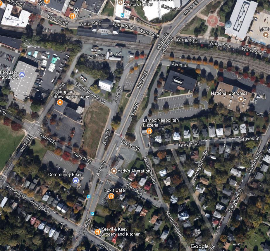
5 Belmont Bridge Replacement PC Comments Preference for no fencing. Emphasized need for good lighting levels across the project Asked staff about potential for additional funding to supplement the current budget. Open design Issues discussion (summary to follow) Planning Commission August 8, 2017 Public Comments (selected comments from individual speakers) Preference for full movement turns at Graves Safety should be top priority in decisions on crosswalks and access Preference to maintain at-grade crossing for better overall connectivity Limited access at graves must consider negative impacts to traffic patterns within the neighborhood
6 Belmont Bridge Replacement Overall Design Approach Want to minimize overall impact of concrete surfaces and massing Want more integrated design details (i.e. site furnishings) Concern regarding segmented look of bridge elevation make efforts to present a smooth curvilinear form Concern regarding new plaza design on pavilion event operations and security BAR August 15, 2017 Paving No consensus on Board about color palette. Some lean toward bold statement as shown and others toward muted, more subtle approach. Recommend looking at alternative materials beyond, or in addition to, colored concrete. Like concept for contrasting pavement finishes in parking areas. Site Furnishings / Integrated design Strong consensus for contemporary site furnishings in lieu of city standards; need to coordinate furnishings with overall design
7 Belmont Bridge Replacement Lighting Questioned ability to vary height and spacing could low level fixtures illuminate the street? Like railing light feature BAR August 15, 2017 Landscaping Create as much soil volume for trees as possible Species selection OK except Sycamore Combine gateway and Ninth Street zones single species Pedestrian Underpass General support for this feature Want to see more detail regarding scale and lighting to ensure a safe and attractive environment Improve circulation to and from passageway for smooth pedestrian flows
8 Belmont Bridge Replacement Railroad fencing General observation that including this element enhances the design, with some creativity in the fence profile. BAR August 15, 2017 Signature ramp/stair feature Can footprint of overall feature be reduced - some debate regarding importance of this feature Should eastern stair feature be oriented to the east? Wall Treatments North abutment wall add more interest Green Walls reduce amount of green walls; select locations carefully relative to growing conditions; use other landscaping to mitigate wall scale; Graffiti it will happen organically be prepared; support for dedicated locations for commissioned murals; Cladding generally support proposed materials;
9 Open Design Issue Update

 2 crashes involved pedestrians in/near existing crosswalk Existing 6% grade along")

10 Pedestrian Circulation South of Railroad Issues Summary At-Grade Crossing at Graves Street Crossing is a desirable, convenient location for Belmont residents to cross 9 th Street Conflicting and potentially unsafe conditions at crossing 9 Crashes at Graves and 9 th Street ( ) 2 crashes involved pedestrians in/near existing crosswalk Existing 6% grade along 9 th Street high travel speeds Existing crosswalk is 190 north of signalized crosswalk at 9 th /Avon/Graves/Levy Intersection Crosswalk is not in accordance with Streets That Work or VDOT guidance
11 Pedestrian Circulation South of Railroad Current Concept Pedestrian passageway beneath 9 th Street Provides east-west accessible route under 9 th Street for bikes and pedestrians 10 +/- tall and 21 wide emphasis on good lighting Opportunity to promote new, safer mobility patterns Will help activate 6th Street, South Street and Old Avon Block with planned redevelopment Maintain existing pedestrian crosswalk north of Graves Street on 9th Stairs on west side and/or sidewalk in Old Avon R/W provide access to 9 th Street Pedestrian upgrades at intersection at Levy Old Avon Garrett for improved mobility
12 Pedestrian Circulation South of Railroad Steering Committee Endorsed Maintain existing pedestrian crosswalk north of Graves Street on 9 th Street Construct pedestrian passageway beneath 9 th Street Stairs on west side and/or sidewalk in Old Avon R/W provide access to 9th Street Pedestrian upgrades at intersection at Levy Old Avon Garrett for improved mobility PC Endorsed Maintain existing pedestrian crosswalk north of Graves Street on 9 th Construct pedestrian passageway beneath 9 th Street Stairs on west side and/or sidewalk in Old Avon R/W provide access to 9th Street Pedestrian upgrades at intersection at Levy Old Avon Garrett for improved mobility Staff / Consultant Recommendation Remove existing pedestrian crosswalk north of Graves Street on 9 th Construct pedestrian passageway beneath 9 th Street Stairs on west side and/or sidewalk in Old Avon R/W provide access to 9th Street Pedestrian upgrades at intersection at Levy Old Avon Garrett for improved mobility
13 Graves Street Access Issues Summary Existing condition allows full movement turn entering and exiting Graves at 9th Street South-bound left turns on to 9th can create congestion on east side, impact traffic on 9th Street New Data Inputs Traffic Counts and Field Observations Current Concept Prohibit left turns from Graves Street to 9 th Street (Avon Street) SB Allow left turns from 9 th Street (Avon Street) SB Allow right-in and right-out movements from Graves Street
")
14 Graves Street Access Steering Committee Endorsed : Prohibit left turns from Graves Street to 9 th Street (Avon Street) SB Allow left turns from 9 th Street (Avon Street) SB Allow right-in and right-out movements from Graves Street PC Requested more information on counts and alternatives: Staff / Consultant Recommendation: Prohibit left turns from Graves Street to 9 th Street (Avon Street) SB Allow left turns from 9 th Street (Avon Street) SB Allow right-in and right-out movements from Graves Street

15 Graves Street Access

 Stairs/Mezzanine Connection between bridge and Water Street for NW to NE pedestrian")
16 Vertical Circulation North of Water Street Issues Summary Lack of connectivity / Accessible routes east to west Lack of vertical circulation from Water Street to bridge Current Concept Stairs to Water Street from 9 th Street: NW Quadrant (Sprint Pavilion Side) NE Quadrant (Lexus Nexus Side) Stairs/Mezzanine Connection between bridge and Water Street for NW to NE pedestrian connection
17 Vertical Circulation North of Water Street PC Comments Expressed concern regarding costs of ramp solution - requested more information on the cost trade-offs to add ramp improvements Endorsed Mezzanine Endorsed Stairs to Water Street in NW and NE quadrants Steering Committee & Staff/Consultant Recommendation: Concerned about impact of costs for ramp solution on overall budget - developing more information on the cost trade-offs to add ramp improvements Recommend Mezzanine Recommend Stairs to Water Street in NW and NE quadrants
 to Downtown")

18 Vertical Circulation North of Water Street Alternatives Under Review NW/NE Ramps from 9 th Street to Mezzanine and NW/NE Stairs to Water Street from Mezzanine: Accessible Route from 9 th Street (both sides) to Downtown Mall No direct accessible route to Water Street from 9 th Street Requires reconstruction of existing block retaining wall on Water Street Cost of wall replacement may reduce aesthetic site improvements due to budget constraints
19 Committee Discussion
20
21 Belmont Bridge Replacement August 16, 2017 Steering Committee PROJECT COSTS Cost of Water Street Wall Work for ADA Ramps $ 2,180,000 Eliminate Aesthetic Bridge Lighting $ (150,000) Eliminate New Pedestrian Passageway $ (460,000) Remove Knuckle (Keep Cantilever for Ramp Conn.) $ (200,000) Remove Seating Walls $ (250,000) VDOT Standard MSE Wall Treatment vs. Decorative Treatment $ (250,000) Striped Crosswalk vs. Stamped Crosswalk $ (132,000) Total Potential Cost Savings $ (1,442,000) Cost opinion of North Abutment Ramp and Possible Cost Reduction Menu Costs above show the total construction cost of items plus mobilization, construction surveying and 20% contingency.
22
23 Belmont Bridge Replacement August 8, 2017 City of Charlottesville Planning Commission To replace an insufficient and deteriorating bridge for vehicular, bicyclists and pedestrian usage To improve pedestrian and bicycle access along this corridor from the Belmont neighborhood to the downtown mall and neighborhoods to the north To improve aesthetics along this corridor and linkage path to downtown To create a gateway to downtown from the south To create synergy for economic development To minimize disturbing existing utilities To minimize disruption of the CSX/BBRR active rail-line and railroad operations To minimize impact and disruption of Pavilion events To minimize impact and disruption to the Downtown Transit Center To minimize vehicular and pedestrian traffic impact and disruption to surrounding businesses and travelling public Project Purpose and Need per the project RFP
24 Belmont Bridge Replacement August 8, 2017 City of Charlottesville Planning Commission Bridge is the gateway into downtown Maintain 25 MPH speed limit Two lanes one in each direction Views to the mountains and of the railroad tracks should be preserved Innovative, entertaining design Separate pedestrian, vehicles, and bicycles Reduce the bridge length Enhance the landscape design elements on the approaches Accent lighting to showcase the bridge Project Goals and Objectives from City Council adopted language Bike lanes 10, pedestrian lanes 10 and traffic lanes 11
25 Stakeholder & Public Engagement
26 Belmont Bridge Replacement August 8, 2017 City of Charlottesville Planning Commission` 1 Amy Gardner Belmont Neighborhood 2 John Harrison Business Community 3 Patrick Healy Ridge Street Neighborhood 4 Heather Danforth Hill North Downtown Neighborhood 5 Harry Holsinger Martha Jefferson Neighborhood 6 Tim Mohr PLACE Design Task Force 7 Scott Paisley PLACE Design Task Force 8 John Santoski Planning Commission 9 Lena Seville CAT Advisory Board 10 Fred Wolf PLACE Design Task Force 11 Brennan Duncan NDS Traffic Engineer 12 Tony Edwards NDS Development Services Manager 13 Alex Ikefuna NDS Director 14 Jeanette Janiczek NDS UCI Program Manager 15 Carrie Rainey NDS Urban Designer 16 Marty Silman NDS City Engineer Steering Committee
27 Belmont Bridge Replacement August 8, 2017 City of Charlottesville Planning Commission` Technical Committee Matthew Alfele Missy Creasy Jay Davis Brennan Duncan Susan Elliott Tom Elliott Craig Fabio David Frazier Chris Gensic Brian Haluska Christian Chirico Charles Kanary Juwhan Lee John Mann NDS Neighborhood Planner NDS Assistant Director City Fire Marshal NDS Traffic Engineer P/W Environmental NDS Building Code Official NDS Asst. Zoning Administrator NDS VSMP E&S Specialist Parks and Trail Planner NDS Neighborhood Planner Public Utilities Gas Utility Project Assistant CAT Acting Asst. Transit Mgr. - Maintenance CAT Asst. Transit Mgr. Operations Parks Landscape Manager Jason McIlwee Camie Mess Heather Newmeyer Stacy Pethia Amanda Poncy Carrie Rainey Michael Ronayne Mary Joy Scala William Scalfani Rick Siebert Marty Silman Lance Stewart Dan Sweet Tich Tablan Stephen Walton Public Utilities Engineer NDS Historic Preservation Assistant NDS Neighborhood Planner NDS Housing Program Coordinator NDS Bicycle and Pedestrian Coordinator NDS Urban Designer Parks NDS Preservation & Design Planner Police Crime prevention Unit Parking Manager NDS City Engineer P/W Public Services / Facilities Mgr. P/U Stormwater Utility Administrator Assistant Fire Marshal Assistant Fire Marshal
28 Belmont Bridge Replacement August 8, 2017 City of Charlottesville Planning Commission ADA Advisory Committee Bicycle and Pedestrian Advisory Committee Board of Architectural Review Stakeholder Groups Downtown Business Association of Charlottesville / Chamber of Commerce PLACE Design Task Force Planning Commission Tree Commission


29 Outreach & Engagement Since February , ,500+ 1,250+ touch points individual data points written comments Steering Committee Meetings x4 Small Stakeholder Group Meetings x18 Mobility Summit 100+ attendees MetroQuest Survey 896 responses Design Charrette 3 days + 3 public sessions Open House 60+ attendees Topical Online Survey 244 responses Belmontbridge.org 2,196 unique users 8,053 page views


30 Public Input: Common Themes and Key Takeaways Design a functional, integrated design Improve connectivity emphasis on relationship between downtown and neighborhoods Design focus on multimodal functionality and safety Create safe bike and pedestrian facilities Include improved, safe street crossings calm traffic to reduce travel speed Improve intersections and approaches (traffic functions, bike/pedestrian safety, aesthetics) Do not negatively impact access to local businesses Create opportunities for landscaping and public spaces Address short term and long term parking needs

31 Open House Takeaways June 1, 2017 Supported: Overall Corridor Plan: closing Old Avon at Garrett Supported: Protected bike lane and wide sidewalks Supported: No Landscaped medians wider perimeter landscape on approaches Supported: Lighting approach More Discussion: Options for at-grade crosswalk and passageway under 9 th Street More Discussion: Turning movements at Graves Street and 9 th Street More Discussion: Stairs on east and west sides with mezzanine connection study ADA ramp options
32 Conceptual Design
33 Corridor Plan


34 Roadway Sections Looking North on 9 th St. on Belmont Bridge Looking North on 9 th St. from Graves St. Looking North on 9 th St. from North of Bridge

35 Vertical Circulation North Abutment Preferred: Central and West Stairs w/ Mezz Rendering Aerial Looking West


36 Vertical Circulation North Abutment Preferred: Central and West Stairs w/ Mezz Renderings - Looking East to Bridge
37 Vertical Circulation North Abutment Preferred: Central and West Stairs w/ Mezz Update Rendering Water St. Looking Northeast

38 Piers Update no skirt Rendering Looking Southeast from Water Street


39 Railroad Fencing Concept 2 Cable Net 98% Transparency Section View From Bridge Sidewalk


40 Lighting Pedestrian Walkway Perspective Views Landscape Forms FGP Pedestrian Light


41 Lighting Site and Accent Lighting Types Recessed Wall Fixture at Parapet Recessed Handrail Fixture

42 Lighting Perspective Views Site and Accent Update Rendering From Mall Looking South East Recessed Wall Fixtures


43 Walls Formed Precast Precast Panels - Modules Precast Concrete: Modular Panel System Blue Ridge Mountain Outcropping Intermittent Shadows Produced by Convex /Concave Faceted Panels Model Views


44 Walls Green Screen Trellis Panel on Masonry Wall Trellis Panel: 3-4 module Precast mounting Detail Model Views
45 Walls: North Abutment Perspective from East on Water St. Water St West

46 Walls: North Abutment Perspective from South Water St West


47 Walls: South Abutment West Elevation Flat and Beveled Modular Precast Panels 3 modular Green Screen Panels Location for Mural or Graffiti West Elevation - Typical Components Water St West West Tunnel
48 Belmont Bridge Replacement August 8, 2017 City of Charlottesville Planning Commission Meets Transportation Goals Summary Existing Conditions Two 6 wide sidewalks One partial 5 wide bike lane/sharrows traveling south At-grade crossings across 9 th Street at Levy Avenue and Graves Street. Comprehensive Plan Consistency Proposed Two 10 wide sidewalks Two 10 wide protected bike lanes At-grade crossing across 9th Street at Levy Avenue Pedestrian passageway under 9th Street, north of Graves Street. New connection from east side of bridge to Downtown Mall & Water Street. New connection from west side of bridge from Downtown Mall & Water Street.
49 Belmont Bridge Replacement August 8, 2017 City of Charlottesville Planning Commission Meets - Transportation Goals Goal 1: Increase safe, convenient and pleasant accommodations for pedestrians, bicyclists, and people with disabilities that improve the quality of life within the community and within individual neighborhoods. Comprehensive Plan Consistency 1.2: Provide convenient and safe pedestrian connections within ¼ miles of all commercial and employment centers, transit routes, schools and parks. 1.3 : Provide design features on roadways, such as street trees within buffers, street furniture and sidewalk widths that improve the safety and comfort level of all users and contribute to the City s environmental goals. 1.4: Explore and implement safe, convenient and visually attractive crossing alternatives to enable pedestrians and bicycles to cross major thoroughfares 1.5: Continue to include bicycle and pedestrian accommodations in conjunction with the planning and design of all major road projects, all new development and road paving projects 1.6 : Consistently apply ADA standards to facility design and ensure that accessible curb ramps exist at all pedestrian crossings where conditions allow.
50 Belmont Bridge Replacement August 8, 2017 City of Charlottesville Planning Commission Meets - Urban Design Goals: Summary Per the public comment received, design focus is on seeking to blend and connect the new bridge into the surrounding neighborhoods with simple but modern and/or funky design features. Comprehensive Plan Consistency The project is proposing to close Old Avon Street at the Garrett/Levy/9th intersection to create a pedestrian zone. Both the pedestrian passageway and mezzanine will be designed to encourage pedestrian use through good design concepts. Enhanced landscaping is also proposed. This project will be coordinated with the Virginia Department of Historic Resources as well as receive a Certificate of Appropriateness from the City s Board of Architectural Review. The project provides for upgraded pedestrian and bicycle facilities, including upgraded multi-modal connections from the pedestrian mall in downtown Charlottesville to the Belmont and Martha Jefferson neighborhoods. Opportunities for art are being proposed along the bridge s abutment walls south of the railroad tracks as well as preservation of a programmed space for graffiti or commissioned art. The extensive public participation process is ensuring design excellence and seeks to meet the community s present and future needs.
51 Belmont Bridge Replacement August 8, 2017 City of Charlottesville Planning Commission Meets - Urban Design Goals Goal 1: Continue Charlottesville s history of architectural and design excellence by maintaining existing traditional features while encouraging creative, context-sensitive, contemporary planning and design Comprehensive Plan Consistency 1.1: Emphasize the importance of public buildings, public spaces, and other public improvements as opportunities to promote a sense of place and a welcoming environment for residents and visitors. 1.2: Promote Charlottesville s diverse architectural and cultural heritage by recognizing, respecting, and enhancing the distinct characteristics of each neighborhood. 1.3: Facilitate development of nodes of density and vitality in the City s Mixed Use Corridors, and encourage vitality, pedestrian movement, and visual interest throughout the City. 1.4: Develop pedestrian friendly environments in Charlottesville that connect neighborhoods to community facilities, to commercial areas and employment centers, and that connect neighborhoods to each other, to promote a healthier community. 1.5: Encourage community vitality and interaction through the incorporation of art in public spaces, neighborhoods, signage, and gateways. 1.6: Encourage the incorporation of meaningful public spaces, defined as being available to the general public, into urban design efforts. 1.7: Promote design excellence for public projects and installations at all scales.
52 Belmont Bridge Replacement August 8, 2017 City of Charlottesville Planning Commission AGENDA Process Overview Review for Comprehensive Plan Consistency Public Engagement Overview Conceptual Design Review Next Steps BAR Presentation #1 August 15 Steering and Technical Committee August / September BAR Presentation #2 TBD City Council Presentation and Action TBD Public Engagement + Stakeholder Input + Conceptual Design
53 Thank you. Questions?
54 Reference slides
55 Pedestrian Circulation Option 1. Construct a pedestrian underpass Option 2 Maintain existing at-grade crossing Option 3 Do both
56 Pedestrian Circulation Potential At Grade Crossing near Graves St. Pedestrian Passageway Opening Section Key View Looking North within passageway
57 Graves Street Access Alternative 1 Restrict left turns from southbound 9th Street to Graves Street; Allow right turns onto and from Graves Street (but prohibit left turns from Graves Street to southbound 9th Street) Alternative 1A Allow left turns from southbound 9th Street to Graves Street; Allow right turns onto and from Graves Street (but prohibit left turns from Graves Street to southbound 9th Street)

58 Graves St. Access Alternative 1 This alternative includes a concrete median that prevents vehicles from turning onto Graves St. from southbound 9 th St. Vehicles also are permitted to turn right in and out of Graves St. Vehicles cannot turn left from Graves St. Alternative 1A This alternative allows vehicles to turn left onto Graves St. from southbound 9 th St. Vehicles are also permitted to turn right in and out of Graves St. Vehicles cannot turn left from Graves St.
59 Vertical Circulation Concepts Concept 1 Stairs on east and west side with a mezzanine connection between 9th Street and Water Street Concept 2 Stairs on east and west side (no mezzanine connection) Concept 3 Stairs on east side with a mezzanine connection between 9th Street and Water Street. No west side stairs to Water Street.

 East and West stairs to Water")

60 Vertical Circulation Option 1 Stairs on east side and west side with Mezzanine connection East and West stairs to Water St. Mezzanine connection to west side stairs Option 2 Stairs on east side and west side (NO Mezzanine connection) East and West stairs to Water St. Option 3 Stairs on east side and with Mezzanine connection East and West stairs to Water St. Mezzanine connection to West stairs VIEW LOOKING NORTH FROM WATER ST

61 Vertical Circulation

62 Vertical Circulation North Abutment Preferred: Central and West Stairs w/ Mezz Update Rendering Water St. Looking Northeast

63 Vertical Circulation North Abutment Preferred: Central and West Stairs w/ Mezz Rendering Water Street looking West


64 Vertical Circulation ADA Ramp to Mezzanine 215 Linear Feet of Ramp Requires 2,200 SF of ROW Purchase Would be necessary to replace the Water St. retaining wall ADA Ramp from 9 th St. to Water St. 440 Linear Feet of Ramp Requires 4,000 SF of ROW Purchase

65 Pedestrian Circulation SC Direction Option 1. Construct a pedestrian underpass Option 2 Maintain existing at-grade crossing Option 3 Do both
66 Graves Street Access SC Direction Alternative 1 Restrict left turns from southbound 9th Street to Graves Street; Allow right turns onto and from Graves Street (but prohibit left turns from Graves Street to southbound 9th Street) Alternative 1A Allow left turns from southbound 9th Street to Graves Street; Allow right turns onto and from Graves Street (but prohibit left turns from Graves Street to southbound 9th Street)
67 Vertical Circulation Concepts SC Direction Concept 1 Stairs on east and west side with a mezzanine connection between 9th Street and Water Street Concept 2 Stairs on east and west side (no mezzanine connection) Concept 3 Stairs on east side with a mezzanine connection between 9th Street and Water Street. No west side stairs to Water Street.
68 SC Endorsement
Alexander Ikefuna City of Charlottesville Director of Neighborhood and Development Services
 To: CC: From: Alexander Ikefuna City of Charlottesville Director of Neighborhood and Development Services Jeanette Janiczek, City of Charlottesville UCI Program Manager, NDS Tony Edwards, City of Charlottesville
APPENDIX A: Complete Streets Checklist DRAFT NOVEMBER 2016
 APPENDIX A: Complete Streets Checklist DRAFT NOVEMBER 2016 Complete Streets Checklist MetroPlan Orlando s Complete Streets Checklist is an internal planning tool for staff to further implementation of
MAG Town of Cave Creek Bike Study Task 6 Executive Summary and Regional Significance Report
 Page 1 MAG Town of Cave Creek Bike Study Task 6 Executive Summary and Regional Significance Report August 1, 2012 MAG Project #481 Page 2 Task 6 Executive Summary and Regional Significance Report Introduction
MARTIN LUTHER KING JR. WAY
 OCTOBER 2011 40 Vision and Goals The Martin Luther King, Jr. Way Illustrative Master Plan that follows has been developed through a process of community involvement. It expresses a long term vision for
Executive Summary Route 30 Corridor Master Plan
 Route Corridor Master Plan Project Overview The Route Corridor Master Plan is a coordinated multimodal transportation and land use plan for the entire stretch of Route through East Whiteland Township,
Exhibit 1 PLANNING COMMISSION AGENDA ITEM
 Exhibit 1 PLANNING COMMISSION AGENDA ITEM Project Name: Grand Junction Circulation Plan Grand Junction Complete Streets Policy Applicant: City of Grand Junction Representative: David Thornton Address:
Living Streets Policy
 Living Streets Policy Introduction Living streets balance the needs of motorists, bicyclists, pedestrians and transit riders in ways that promote safety and convenience, enhance community identity, create
5 CIRCULATION AND STREET DESIGN
 5 CIRCULATION AND STREET DESIGN This chapter describes circulation and streetscape improvements proposed for the Northwest Chico Specific Plan Area. It includes detailed design specifications for existing
Item to be Addressed Checklist Consideration YES NO N/A Required Description Complete Streets Guidelines
 Passaic County Complete Streets Checklist - Concept Development Project Name Item to be Addressed Checklist Consideration YES NO N/A Required Description Complete Streets Guidelines Existing Plans Have
Proposed. City of Grand Junction Complete Streets Policy. Exhibit 10
 Proposed City of Grand Junction Complete Streets Policy Exhibit 10 1 City of Grand Junction Complete Streets Policy Vision: The Complete Streets Vision is to develop a safe, efficient, and reliable travel
Hennepin County Transportation Department
 Hennepin County Transportation Department Complete Streets Design and Implementation Prepared for the Complete Streets Task Force Craig Twinem, P.E. Design Division Manager Tom Johnson, P.E. Transportation
Chapter 5 Future Transportation
 Chapter 5 Future Transportation The Future Land Use Plan identifies the desired land use designations. The land uses desired for Crozet depend, in large part, on the success of the transportation system,
Vision: Traditional hamlet with an attractive business/pedestrian friendly main street connected to adjacent walkable neighborhoods
 N D. Focus Area II Vision: Traditional hamlet with an attractive business/pedestrian friendly main street connected to adjacent walkable neighborhoods Transit Road Focus Area II is located in the Hamlet
EXECUTIVE SUMMARY. Vision
 Vision Walking and bicycling in Salt Lake City will be safe, convenient, comfortable, and viable transportation options that connect people to places, foster recreational and economic development opportunities,
Comments EXECUTIVE SUMMARY
 Comments 1. Under any Alternatives, MCDOT should provide better at-grade pedestrian crossing of Georgia Avenue and Forest Glen Road, including improved crosswalks with wider medians and adequate signal
CONNECTIVITY PLAN. Adopted December 5, 2017 City of Virginia Beach
 CONNECTIVITY PLAN Adopted December 5, 2017 City of Virginia Beach CONTENTS 1.0 Background & Purpose... 2 2.0 Existing Inventory & Analysis... 3 ViBe District Existing Walking Conditions... 4 3.0 ViBe District
HARRISON STREET/OAKLAND AVENUE COMMUNITY TRANSPORTATION PLAN
 HARRISON STREET/OAKLAND AVENUE Community Workshop #4: Draft Plan Review December 3, 2009 D E S I G N, C O M M U N I T Y & E N V I R O N M E N T INTRODUCTIONS Key Project Staff: Alisa Shen, Project Manager,
A CHANGING CITY. of Edmonton, it is essential that it reflects the long-term vision of the City.
 A CHANGING CITY By the year 2040, Edmonton will be home to more than 1 million people. To accommodate growth and support a healthy and compact city, we need a new approach to development/redevelopment
5. RUNNINGWAY GUIDELINES
 5. RUNNINGWAY GUIDELINES These guidelines should be considered collectively when making runningway decisions. A runningway is the linear component of the transit system that forms the right-of-way reserved
Ocean Park Boulevard Green Street Project Alternatives & Trade Offs
 Planning Commission March 4, 2009 Ocean Park Boulevard Green Street Project Alternatives & Trade Offs Purpose of Tonight s Meeting Review concept plans and options Provide input on alternatives and trade-offs
BROOKLAND Multi-Modal Transportation & Streetscape Study* NE Washington, DC
 BROOKLAND Multi-Modal Transportation & Streetscape Study* NE Washington, DC The study s goal is to create a multi-modal transportation and streetscape design plan to increase transportation efficiency,
Tonight is for you. Learn everything you can. Share all your ideas.
 Strathcona Neighbourhood Renewal Draft Concept Design Tonight is for you. Learn everything you can. Share all your ideas. What is Neighbourhood Renewal? Creating a design with you for your neighbourhood.
THE ALAMEDA CONCEPT DESIGN COMMUNITY MEETING 3. A Plan for The Beautiful Way JANUARY 28, 2010
 CONCEPT DESIGN COMMUNITY MEETING 3 JANUARY 28, 2010 AGENDA INTRODUCTION COMMUNITY INPUT ROADWAY STUDIES STREETSCAPE DESIGN STATIONS DISCUSSION SUMMARY AND DISCUSSION NEXT STEPS CLOSE INTRODUCTION SCHEDULE
PUBLIC REALM MASTER PLAN
 WESTSHORE BUSINESS DISTRICT PUBLIC REALM MASTER PLAN MASTER PLAN COMMITTEE MEETING MARCH 20, 2013 WESTSHORE BUSINESS DISTRCT PUBLIC REALM MASTER PLAN MACRO-SCALE CONCEPT: A PUBLIC REALM FRAMEWORK DEFINED
Broad Street Bicycle Boulevard City Council Study Session Summary
 Broad Street Bicycle Boulevard City Council Study Session Summary Overview: On August 15 th, 2017, a City Council Study Session was held to invite community input and request City Council guidance on a
Agenda. Overview PRINCE GEORGE S PLAZA METRO AREA PEDESTRIAN PLAN
 PRINCE GEORGE S PLAZA METRO AREA PEDESTRIAN PLAN May 28, 2008 Agenda Welcome and introductions Project overview and issue identification Planning context and strengths Design challenges and initial recommendations
NM-POLICY 1: Improve service levels, participation, and options for non-motorized transportation modes throughout the County.
 Transportation PRINCE WILLIAM COUNTY 2008 COMPREHENSIVE PLAN NON-MOTORIZED PLAN CONTENTS Goals, Policies, and Action Strategies Table 4 (Bike Facility Classifications and Descriptions) Table 5 (Bike Facility
RESOLUTION NO ?? A RESOLUTION OF THE CITY OF NEPTUNE BEACH ADOPTING A COMPLETE STREETS POLICY
 RESOLUTION NO. 2018-?? A RESOLUTION OF THE CITY OF NEPTUNE BEACH ADOPTING A COMPLETE STREETS POLICY WHEREAS, safe, convenient, and accessible transportation for all users is a priority of the City of Neptune
ACTIVE TRANSPORTATION
 ACTIVE TRANSPORTATION Mobility 2040 Supported Goals Improve the availability of transportation options for people and goods. Support travel efficiency measures and system enhancements targeted at congestion
CITY OF COCOA BEACH 2025 COMPREHENSIVE PLAN. Section VIII Mobility Element Goals, Objectives, and Policies
 CITY OF COCOA BEACH 2025 COMPREHENSIVE PLAN Section VIII Mobility Element Goals, Objectives, and Policies Adopted August 6, 2015 by Ordinance No. 1591 VIII MOBILITY ELEMENT Table of Contents Page Number
APPROVE A RESOLUTION ADOPTING A COMPLETE STREETS POLICY
 STAFF REPORT MEETING DATE: September 13, 2016 TO: FROM: City Council Bob Brown, Community Development Director Russ Thompson, Public Works Director Patrick Filipelli, Management Analyst 922 Machin Avenue
Community Meeting February 27, 2007 Dorchester Avenue Transportation & Streetscape Improvements Action Plan February 27, 2007
 Community Meeting Tonight s Agenda 6:00 Introductions South Boston/Dot Ave Improvement Study Background 6:15 Consultant Introductions Review of Scope and Schedule Review of Proposed Corridor Wide Guidelines
East Burke Transportation, Safety and Capacity Improvements
 East Burke Transportation, Safety and Capacity Improvements The purpose of this project is to increase mobility and improve safety for pedestrians, cyclists, and motor vehicles along VT Route 114 in the
Dr. M.L. King, Jr. Street North Complete Streets Resurfacing Opportunities HOUSING, LAND USE, AND TRANSPORTATION COMMITTEE MARCH 22, 2018
 Dr. M.L. King, Jr. Street North Complete Streets Resurfacing Opportunities HOUSING, LAND USE, AND TRANSPORTATION COMMITTEE MARCH 22, 2018 What s Happening The City plans to mill and resurface Dr. M.L.
Broad Street Bicycle Boulevard Design Guidelines
 Broad Street Bicycle Boulevard Design Guidelines Building from the strategies introduced in the 2013 Bicycle Transportation Plan and community input received thus far, City Transportation Staff have identified
Commerce Street Complete Street Project from Good Latimer Expressway to Exposition Avenue
 Commerce Street Complete Street Project from Good Latimer Expressway to Exposition Avenue T A N Y A B R O O K S A S S I S T A N T D I R E C T O R M O B I L I T Y P L A N N I N G M O B I L I T Y A N D S
City of Novi Non-Motorized Master Plan 2011 Executive Summary
 City of Novi Non-Motorized Master Plan 2011 Executive Summary Prepared by: February 28, 2011 Why Plan? Encouraging healthy, active lifestyles through pathway and sidewalk connectivity has been a focus
Henderson Ave. Complete Streets Project
 Henderson Ave. Complete Streets Project Meeting Purpose To finalize conceptual components of project prior to proceeding with preliminary engineering www.dallascompletestreets.wordpress.com MeetingAgenda
REGIONAL BICYCLE AND PEDESTRIAN DESIGN GUIDELINES
 REGIONAL BICYCLE AND PEDESTRIAN DESIGN GUIDELINES November 16, 2011 Deb Humphreys North Central Texas Council of Governments Bicycle and Pedestrian Advisory Committee Snapshot of the Guide 1. Introduction
CONNECTING PEOPLE TO PLACES
 CONNECTING PEOPLE TO PLACES 82 EAST BENCH MASTER PLAN 07 Introduction The East Bench transportation system is a collection of slow moving, treelined residential streets and major arteries that are the
WELCOME. City of Eden Prairie West 70 th Street
 WELCOME City of Eden Prairie West 70 th Street Project Schedule Sep Oct Nov Dec Jan Feb Mar Apr May Jun Jul Aug >>> May WEST SEGMENT Concept Plan Fall 2014 Plan Development Winter 2014 Summer 2015 Construction
Santa Monica Pier Bridge Replacement Community Workshop
 Santa Monica Pier Bridge Replacement Community Workshop Summary Date: To: Jim Rucker, T.Y. Lin International From: Rick Barrett, Project Manager, MIG, Inc. Re: Summary notes from Community Workshop held
Perryville TOD and Greenway Plan
 Perryville TOD and Greenway Plan Greenway Glossary Pathway: A bicycle and pedestrian path separated from motorized vehicular traffic by an open space, barrier or curb. Multi-use paths may be within the
Road Diets FDOT Process
 Florida Department of TRANSPORTATION Road Diets FDOT Process Humberto Castillero, PE, PTOE Roadway Design Office Purpose of Guide Develop a statewide lane elimination review process Balance state & local
Solana Beach Comprehensive Active Transportation Strategy (CATS)
") Solana Beach Comprehensive Active Transportation Strategy (CATS) 3.0 Goals & Policies The Solana Beach CATS goals and objectives outlined below were largely drawn from the Solana Beach Circulation Element
Solana Beach Comprehensive Active Transportation Strategy (CATS) 3.0 Goals & Policies The Solana Beach CATS goals and objectives outlined below were largely drawn from the Solana Beach Circulation Element
Technical Working Group November 15, 2017
 Technical Working Group November 15, 2017 Welcome and Introductions Project Partners Regional Transportation District (RTD) Colorado Department of Transportation (CDOT) Denver Regional Council of Governments
Knox Street Complete Streets Project
 Knox Street Complete Streets Project Meeting Purpose Get community feedback on two conceptual street design options Meeting Agenda Presentation (20 minutes) Project background and schedule Summary of preferences
San Jose Transportation Policy
 San Jose Transportation Policy Protected Intersections in LOS Policies to Support Smart Growth Presented by: Manuel Pineda City of San Jose Department of Transportation Bay Area Map San Francisco Oakland
7/23/2017 VIA . Michael Hanebutt City of Sacramento Community Development Department 300 Richards Boulevard, 3 rd Floor Sacramento, CA 95811
 7/23/2017 VIA EMAIL Michael Hanebutt City of Sacramento Community Development Department 300 Richards Boulevard, 3 rd Floor Sacramento, CA 95811 RE: 65 th Street Apartments (DR17-220) Dear Mr. Hanebutt:
Chapter 3: Multi-Modal Circulation and Streetscapes
 CHAPTER 3: MULTI-MODAL CIRCULATION AND STREETSCAPES Chapter 3: Multi-Modal Circulation and Streetscapes Overview Streetscape improvements have already been completed for Depot Street between Main Avenue
Ocean Park Boulevard Streetscape Improvement Project Alternatives & Trade Offs
 City Council Study Session January 27, 2009 Ocean Park Boulevard Streetscape Improvement Project Alternatives & Trade Offs Scope of Work Purpose of Tonight s Meeting Review work to date and direct staff
RZC Appendix 8A Marymoor Subarea Street Requirements
 RZC Appendix 8A Marymoor Subarea Street Requirements For additional design details for Marymoor Subarea infrastructure, refer to the 2017 Marymoor Subarea Infrastructure Planning Report. STREET REQUIREMENTS
TRANSPORTATION STANDARDS
 INTRODUCTION LOCAL STREETS ON-STREET PARKING SIDEWALKS STREET LIGHTING STREET FURNISHINGS TRAFFIC CALMING STREET TREES MEDIAN PLANTING BOULEVARD LOCATIONS VILLAGE CENTER STREET LOCATIONS RESIDENTIAL STREET
Non-Motorized Transportation 7-1
 Non-Motorized Transportation 7-1 Transportation facilities no longer mean just accommodating a vehicle powered by a combustion engine. Pedestrian and non-motorized facilities are important modes of travel
Introduction. North 12 th Complete Street Project Overview
 Introduction On Wednesday, March 1, 2017, the City of Sacramento, in partnership with Sacramento Regional Transit District and the Sacramento Housing and Redevelopment Agency, hosted a community outreach
C C C
 C-012-001 Thank you for your support for the creation of new public space and nonmotorized access between downtown and the waterfront through the Overlook Walk, the East-West Connections, and the Promenade.
COWETA HIGH SCHOOL AND EAST HIGHWAY 51
 COWETA HIGH SCHOOL AND EAST HIGHWAY 51 Lack of sidewalks along Ben Lumpkin Rd. Lack of crosswalks and ramps at intersection. Hwy 51 is wide to cross as a pedestrian. No ADA compliance or connection to
City of Wilsonville 5 th Street to Kinsman Road Extension Project
 City of Wilsonville 5 th Street to Kinsman Road Walking Tour & Neighborhood Workshop Summary Report Public Outreach Overview On July 18 th, 2017, the City of Wilsonville hosted a neighborhood walking tour
Lee s Summit Road Improvement Study Public Open House June 7, 2007 Summary of Comment Card Responses
 Lee s Summit Road Improvement Study Public Open House June 7, 2007 Summary of Comment Card Responses Introduction At the Lee s Summit Road Improvement Study Public Open House held Thursday, June 7, 2007
CITY OF SLO SEEKS INPUT ON PREFERRED ALTERNATIVE FOR BROAD STREET BICYCLE BOULEVARD PROJECT
 City of San Luis Obispo, News Release DATE: August 1, 2017 RELEASE: Immediate CONTACT: Luke Schwartz (805) 781-7190 Transportation Planner-Engineer, Public Works CITY OF SLO SEEKS INPUT ON PREFERRED ALTERNATIVE
Pine Hills Road Pedestrian/Bicycle Safety Study Board of County Commissioners Work Session
 Pine Hills Road Pedestrian/Bicycle Safety Study Board of County Commissioners Work Session February 20, 2018 Meeting Agenda Study Overview Existing Conditions Access Management Potential Gateway Features
Arlington s Master Transportation Plan
 Arlington s Master Transportation Plan The Master Transportation Plan (MTP) Adopted in eight parts Goals & Policies element and MTP Map adopted in 2007 Bicycle, Pedestrian and Demand and Systems Management
Environmental Assessment Findings & Recommendations. Public Hearing November 13, 2014
 Environmental Assessment Findings & Recommendations Public Hearing November 13, 2014 Welcome! Welcome and Introductions Project and Environmental Assessment Overview Public Comments Adjourn Purpose of
Active Transportation Rail to River Corridor. Community Meeting - Segment A
 Active Transportation Rail to River Corridor Community Meeting - Segment A June 29, 2017 Tonight s Agenda > Open House (30 min) > Welcome / Project Overview > Presentation of 30% Design Refinements > Next
BETHEL ROAD AND SEDGWICK ROAD CORRIDOR STUDY
 DRAFT PLAN City Council Meeting August 14, 2017 STUDY AREA Sedgwick Corridor State Route 160, principal arterial with Class 3 access management designation, commuter and freight route, connection to SR
PRINCE GEORGE S PLAZA METRO AREA PEDESTRIAN PLAN
 PRINCE GEORGE S PLAZA METRO AREA PEDESTRIAN PLAN May 28, 2008 Agenda Welcome and introductions Project overview and issue identification Planning context and strengths Design challenges and initial recommendations
Item No. 14 Town of Atherton
 Item No. 14 Town of Atherton CITY COUNCIL STAFF REPORT CONSENT AGENDA TO: THROUGH: FROM: HONORABLE MAYOR AND CITY COUNCIL GEORGE RODERICKS, CITY MANAGER MICHAEL KASHIWAGI, COMMUNITY SERVICES DIRECTOR MARTY
GRTC Bus Rapid Transit: Semi-Final Design Phase Public Meetings: October 26 & 27, 2015
 GRTC Bus Rapid Transit: Semi-Final Design Phase Public Meetings: October 26 & 27, 2015 Welcome! Meeting Agenda Project update presentation Up to 15 minutes for Pulse Q&A about project design. (Please reserve
Community Task Force November 15, 2017
 Community Task Force November 15, 2017 Welcome and Introductions Project Partners Regional Transportation District (RTD) Colorado Department of Transportation (CDOT) Denver Regional Council of Governments
Mainstreet Master Plan Land Use
 Mainstreet Master Plan 04 Land Use Top Recommendations Active Uses: Promote active ground-floor uses such as retail, restaurants, galleries and personal services with interactive storefronts for Mainstreet
TRANSPORTATION COMMISSION Agenda Staff Report
 TRANSPORTATION COMMISSION Agenda Staff Report Agenda Item No. 5.a DATE: JULY 31, 2014 TO: FROM: SUBJECT: TRANSPORTATION COMMISSION COMMUNITY DEVELOPMENT DEPARTMENT - PLANNING DRAFT OLYMPIC CORRIDOR PREFERRED
Route 79/Davol Street Corridor Study
 Route 79/Davol Street Corridor Study Fall River, MA Public Information Meeting #2 November 21, 2013 Fall River Heritage State Park Fall River, MA Agenda Welcome and Introductions Overview of Study Process
Toward Zero Deaths. Regional SHSP Road Show Meeting. Virginia Strategic Highway Safety Plan. presented by
 Toward Zero Deaths Regional SHSP Road Show Meeting presented by Virginia Strategic Highway Safety Plan December 1, 2016 1 Welcome & Introductions Purpose of the Meeting Objectives & Key Outcomes Agenda»
Roadway Classification Design Standards and Policies. Pueblo, Colorado November, 2004
 Roadway Classification Design Standards and Policies Pueblo, Colorado November, 2004 Table of Contents Page Chapter 1. General Provisions 1.1 Jurisdiction 3 1.2 Purpose and Intent 3 1.3 Modification 3
Governance and Priorities Committee Report For the July 2, 2015 Meeting
 CITY OF VICTORIA For the July 2, 2015 Meeting To: Governance and Priorities Committee Date: From: Subject: Brad Dellebuur, A/Assistant Director, Transportation and Parking Services Executive Summary The
WHEREAS delivery trucks also pass through the Narrows, into the northern parking lot, to loading docks in the back of the building.
 CEDAR-ISLES-DEAN NEIGHBORHOOD ASSOCIATION ( CIDNA ) RESOLUTION OPPOSING A DRUG STORE DRIVE THRU, AND COMMENDING DORAN COMPANIES FOR PROPOSING MITIGATING AMENITIES INCLUDING NEW LANDSCAPING AND A DEDICATED
SAN FRANCISCO MUNICIPAL TRANSPORTATION AGENCY
 THIS PRINT COVERS CALENDAR ITEM NO. : 10.2 DIVISION: Sustainable Streets BRIEF DESCRIPTION: SAN FRANCISCO MUNICIPAL TRANSPORTATION AGENCY Adopting Conceptual Proposal for Streetscape Improvements to Broadway,
STEERING COMMITTEE MEETING June 17, Streetscape Overview Burlington Comprehensive Master Plan
 STEERING COMMITTEE MEETING June 17, 2015 Streetscape Overview Burlington Comprehensive Master Plan 1 Introduction Slide This slide show was presented to the Burlington Steering Committee on June 17, 2015
WHITE STREET/ ENGLISH PLAZA STREETSCAPE IMPROVEMENT PROJECT
 WHITE STREET/ ENGLISH PLAZA STREETSCAPE IMPROVEMENT PROJECT 1 Project Goals 1 Improved Safety: Lighting, Multi-Modal Circulation, Emergency Access, Tripping Hazards; Stormwater 4 Environmental Performance:
Circulation in Elk Grove includes: Motor vehicles, including cars and trucks
 Circulation, as it is used in this General Plan, refers to the many ways people and goods move from place to place in Elk Grove and the region. Circulation in Elk Grove includes: Motor vehicles, including
6/14/2013 VIA . Evan Compton, Associate Planner Community Development Department City of Sacramento 300 Richards Blvd Sacramento, CA 95814
 6/14/2013 VIA EMAIL Evan Compton, Associate Planner Community Development Department City of Sacramento 300 Richards Blvd RE: Sacramento Natural Foods Co-Op (P13-025) Dear Mr. Compton: WALKSacramento appreciates
forwarddallas! Implementation Proposed Chapter 43 Code Amendment On-Street Parking
 forwarddallas! Implementation Proposed Chapter 43 Code Amendment On-Street Parking Transportation and Environment Committee Briefing December 10, 2007 PURPOSE Code amendment to establish regulations consistent
Appendix C. TRAFFIC CALMING PROGRAM TOOLBOX
 Appendix C. TRAFFIC CALMING PROGRAM TOOLBOX PHASE I...2 Do Not Enter Sign...3 One-Way Sign...4 Turn Prohibition...5 Pavement Markings...6 Speed Monitoring Trailer...7 Neighborhood Speed Watch...8 Police
Austin Avenue Bridges Project. Public Meeting Summary
 Austin Avenue Bridges Project Public Meeting Summary June 29, 2016 Red Table Safety and Connectivity Notes: 1. Would like to see forensic report evaluations 2. What is the lifespan? 3. Extend safety considerations
Roosevelt Estates Neighborhood Improvements
 Roosevelt Estates Neighborhood Improvements Transportation Alternatives Application May 5 th, 2016 Qualifying Activities Construction of on-road and off-road trail facilities for pedestrians, bicyclists,
RiNo Railroad Crossing Connectivity Analysis. Stakeholder Workshop June 29, 2017
 RiNo Railroad Crossing Connectivity Analysis Stakeholder Workshop June 29, 2017 Ideas and Considerations Presented at Stakeholder Workshop Primary Focus: 38 th Street (between Walnut & Wynkoop) 1 Basic
Public Information Centre
 WELCOME Public Information Centre Father Tobin Road Lougheed Middle School - Library Wednesday November 7, 2012 7:00 p.m.to 9:00 p.m. Please sign in Neighbourhood Traffic Calming Guide Background The City
Chapter 5. Complete Streets and Walkable Communities.
 Chapter 5. Complete Streets and Walkable Communities. 5.1 Description of Complete Streets. Cities throughout the world, and specifically the United States, are coming to embrace a new transportation and
Arapahoe Square Zoning + Design Standards & Guidelines Task Force Meeting 9 January 27, 2016
 Arapahoe Square Zoning + Design Standards & Guidelines Task Force Meeting 9 January 27, 2016 Agenda 3:00 Opening/Welcome 3:15 Touch Base on Schedule and Milestones Moving Forward 3:20 Review the Overall
PEDESTRIAN ACTION PLAN
 ATTACHMENT 2 CITY OF SANTA MONICA PEDESTRIAN ACTION PLAN CITY OF SANTA MONICA PEDESTRIAN ACTION PLAN This page intentionally left blank EXECUTIVE SUMMARY CHAPTER 1 EXECUTIVE SUMMARY Setting the Stage
Outreach Approach RENEW SF served as the primary liaison with the North Beach community; the Chinatown. Executive Summary
 Executive Summary Executive Summary The Columbus Avenue Neighborhood Transportation Study s objective is to identify changes to transportation infrastructure and policies that could enhance the livability
7 Complete Streets & Roadway Aesthetics
 7 Complete Streets & Roadway Aesthetics 7.1 OVERVIEW Our streets lay the foundation for how we interface with travel needs, physical exercise, social exchanges and access to goods and services. They are
City of Gainesville Transportation/Roadway Needs PROJECT SUMMARY
 A1 Roadway Resurfacing $23,846,000 TYPE: Preservation of existing system Roadway resurfacing A2 Signal Replacement $6,000,000 TYPE: Preservation of existing system Replace traffic signals. B1 W 6th St
See Figure 38, Existing Nonmotorized Connections.
 Nonmotorized Connections Existing Nonmotorized Connections Pedestrian, vehicle and bike traffic access and movements are confined primarily to Penny Drive on campus. Due to the steep slope along the length
CHAPTER. Implementation
 CHAPTER Implementation 5 97 The previous chapters of the Guidelines dealt with the principles and elements of street design in Charlottesville, and this chapter covers the process of getting street projects
Road Alterations - Wellington Street East, Church Street, and Front Street Intersection
 REPORT FOR ACTION Road Alterations - Wellington Street, Church Street, and Front Street Intersection Date: November 1, 2016 To: Toronto and York Community Council From: Director, Public Realm Section,
Fulton Market Streetscape
 Fulton Market Streetscape Ogden Avenue to Halsted Street Public Meeting Recommended Improvements December 10th, 2014 Meeting Purpose and Goals Present Existing Conditions Community Input and Charrette
Omaha s Complete Streets Policy
 Omaha s Complete Streets Policy (Adopted August 2015) VISION To create great places and enhance our quality of life, the City of Omaha will provide safe, accessible streets for all users. Complete Streets
Appendix 3 Roadway and Bike/Ped Design Standards
 Appendix 3 Roadway and Bike/Ped Design Standards OTO Transportation Plan 2040 4/20/2017 Page A3-1 Adopted Standards The adopted OTO Design Standards and Major Thoroughfare Plan are contained herein.
Bicycle Master Plan Goals, Strategies, and Policies
 Bicycle Master Plan Goals, Strategies, and Policies Mobilizing 5 This chapter outlines the overarching goals, action statements, and action items Long Beach will take in order to achieve its vision of