Advanced Construction Techniques. Concrete Pavements ACCELERATED CONSTRUCTION OF URBAN INTERSECTIONS WITH PORTLAND CEMENT CONCRETE PAVEMENT (PCCP)
|
|
|
- Gervase Sparks
- 5 years ago
- Views:
Transcription


1 CM 510 Concrete Pavements ACCELERATED CONSTRUCTION OF URBAN INTERSECTIONS WITH PORTLAND CEMENT CONCRETE PAVEMENT (PCCP) Pavements Asphalt pavement has long been a popular road construction material. In areas where traffic becomes concentrated, such as urban intersection, flexible pavement may be prone to rutting over time. In areas with seasonal extremes of both hot and cold weather, the ruts can quickly become severe. Several of the flexible pavement intersections in eastern region of Washington state had been suffering from severe rutting caused by slow moving heavy vehicles, exasperated by high temperatures during the summer months.
 pavement sections has made reconstruction with Portland")


2 Portland Cement Concrete Pavements The frequent maintenance required on some asphalt concrete (AC) pavement sections has made reconstruction with Portland Cement Concrete Pavement (PCCP) a more feasible alternative. In Eastern Washington, three major AC intersections with severe rutting problems were reconstructed with PCCP. The entire reconstruction of each intersection, including demolition of the AC pavement and its replacement with PCCP, took place over a period of three days - starting on Thursday evening and opening the intersection to the traffic on Sunday afternoon. Map of the project area Sites 1, 2 &3
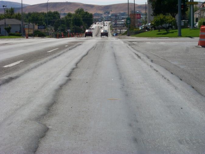
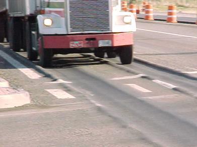
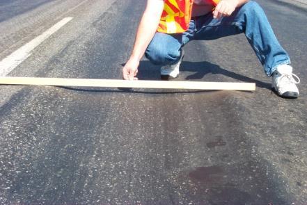
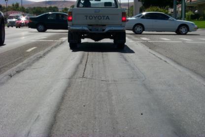
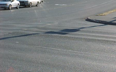
3 The Problem 25,000-30,000 ADT (Average Daily Traffic) with 20 percent trucks Rutting in Asphalt Concrete Pavements


4 Intersection Construction Replace the existing pavement with 12 inches PCCP over the existing crushed stone base Thursday evening to Monday morning closures to construct the intersection square area Detour traffic over surrounding surface streets and state/interstate highway Intersection Construction
5 Planning Prior to Design of this Project, Washington State Department of Transportation (WSDOT) communicated with contractors, and the city about strategies for avoiding some of the inconvenience caused by the previous Contracts. The contractor proposed completing the entire intersection including the radii, if a three day closure was Possible. City allowed full weekend closure, Friday evening to Monday morning, of one intersection at a time. Contractors felt that the entire intersection with the exception of the radii could be completed in this timeframe. Traffic Detours Truck traffic detoured approximately 13 miles on interstate and state highways. Car traffic detoured on local streets. Flaggers placed at all key locations.

6 Traffic Detour Map Public Relations Numerous public meeting were held during the design phase for public input and agreement WSDOT contacted business owners prior to the construction One week before the closure Day before the closure Provided flyers

7 Public Relations Weekly meeting were held by the project engineer to update the local media WSDOT tried to make the closures as painless as possible: Fully signed the detour routes On site changes/refinements to allow traffic flow Aggressive scheduling to ensure a minimum timeline for the closure Variable message signs, flyers, and media notices Construction Staging
8 Staging Concerns Traffic Flow and Traffic Control Access to Adjacent Business Access for Construction & Material Delivery Construction Time Safe Construction Area for Employees and Public Mix Designs Time to Cure and Opening to Traffic Traffic Control Requirements SR-395 & Yelm, Clearwater, Kennewick Avenue: Close one Intersection at a Time Temporary Lane Closures Stages 1,2,3 Complete Closure Stage 4, Thursday at 7:00 PM to Monday 6:00 AM. Late opening penalty of up to $2, per hour. 2,500 psi for opening to traffic.
9 Modification to Traffic Control Plan Place Traffic in NB or SB lanes for several days. Once the traffic flow is modified leave them in the same configuration. Set up Temporary Signals Worked on Two Intersections at Once (Clearwater & Kennewick) No Left Turns to Facilitate Construction Kennewick Intersection Staging Monday AM to Thursday 7:00 PM Complete Approach & Departure Legs on Southbound Legs as Shown in Stage 1 & Stage 2 at both Kennewick & Clearwater Set up Traffic Control for Closure at Clearwater Move materials, (Tie Bars, Dowel Baskets, Forms, etc), into position for easy access
10 Stage 1 Work Zone Traffic Flow Stage 2 Work Zone Traffic Flow

11 Kennewick Intersection Staging Complete Interior Portion of Clearwater Avenue over the weekend Monday through Friday Completed Northbound Approach and Departure Legs at Kennewick & Clearwater Avenue Stage 3 Work Zone Traffic Flow
12 Kennewick Intersection Staging 7:00 PM Thursday to 6:00 AM Monday Close Kennewick Intersection 7:00 PM Thursday Begin Milling at 8:00 PM Start Finish Grading at 2:00 AM Friday Morning. Set Forms 7:00 AM Start Concrete Placement 11:00 AM Complete Daily placement 11:00 PM Friday Evening. Begin Green Sawing 4 to 6 hours after start of placement Kennewick Intersection Staging Saturday Check Maturity Meter 7:00 AM Remove & Reset Forms, Place Baskets 8:00 AM Begin Placing Concrete Complete Concrete placement 4:00 PM Start Cleanup.


13 Stage 4a Stage 4b Stage 4a Stage 4b Work Zone Road Closure

14 Kennewick Intersection Staging Sunday Check Maturity Meter for Required Strength Clean and Seal Joints 7:00 AM to 2:00 PM Set Up Traffic Control for opening Place Traffic on Pavement 6:00 PM Sunday Intersection Complete
15 Time for Completion In 15 days approximately 3384 cubic yards of concrete were placed at Kennewick Avenue and Cleawater. Kennewick Avenue and Clearwater were built concurrently. The concurrent construction saved a considerable amount of time. Crews were able to place concrete daily. Time Comparison to Other Projects Location Days Cubic Yards Francis & Division Broadway & Pines Kennewick, Clearwater
16 Time Components Construction Activity 3% 1% 5% (Joint Seal) 2% 5% (Clean Joints) Closing Roadway Grading 17% (No Activity) 14% (Cure) Form and Place Concrete Cure Joint Seal Prep Roadway for Opening to Traffic No Activity 1% 11% (Sawcutting) 8% (Excavation) Excavation Conduit Repair Sawcutting Clean Joints Clean Roadway Delay 5% (Grading) 1% 27% (Form & Place Concrete) Components of typical turn-around time for a PCCP intersection reconstruction Keys to this Projects Success Good Communication between WSDOT project office and Acme. Key decision makers on site or available at all times. Involvement in the scheduling from subcontractors and suppliers. Hourly schedule for Weekend closures with clear milestones for daily production. Quality Control personnel onsite during all placements.
17 Mix Design Bonus/Penalty for Air Content & Strength evaluated statistically Mix design required 650 flex in 14 days with 28 day cylinders for pay Ultimate 28 day field strengths required to exceed, 28 day lab cured compressive strength less 1000 psi, evaluated statistically psi for opening to traffic in 12 to 16 hours Maturity Meter curves for early opening. Mix Design WSDOT One Day Mix 705 # Type III Cement 940 # 1 1/2 Rock 799 # 3/4 Rock 140 # 3/8 Pea Gravel 590 # Coarse Sand 481# Fine Sand 254 # Water 11 oz/cy AEA 30.3 oz/cy WRA 17.6 oz/cy Delvo (Set Retarder)

18 Maturity Meter Maturity vs. Compressive Strength Maturity vs. Flexural Strength Flexural & Compressive vs. Time Maturity Meter
19 Closing There are many different ways an agency can stage an intersection. The method presented is only one method that worked very well on this project. None of the techniques used to place the concrete are highly specialized. The mix design is very simple and easy to use. High penalties for late openings will increase the initial cost of the intersections to cover contractor risk. Rapid Intersection Reconstruction Kennewick, Washington
Concrete Pavements ACCELERATED CONSTRUCTION OF URBAN INTERSECTIONS WITH PORTLAND CEMENT CONCRETE PAVEMENT (PCCP)
") Concrete Pavements ACCELERATED CONSTRUCTION OF URBAN INTERSECTIONS WITH PORTLAND CEMENT CONCRETE PAVEMENT (PCCP) Pavements Asphalt pavement has long been a popular road construction material. In areas
Concrete Pavements ACCELERATED CONSTRUCTION OF URBAN INTERSECTIONS WITH PORTLAND CEMENT CONCRETE PAVEMENT (PCCP) Pavements Asphalt pavement has long been a popular road construction material. In areas
IL Route 71 Construction Update
 100 Parkers Mill Oswego, IL. 60543 (630) 554-3618 4.20.16 IL 71 TRAFFIC ADVISORY: Tentatively scheduled for April 21st A new traffic pattern from Paradise to Wolf Crossing on IL 71 will be in use. The
Use of Roller Compacted Concrete By GDOT. Presented By: Joe W. Sheffield, PE Georgia Department of Transportation District Engineer, Tifton, GA
 Use of Roller Compacted Concrete By GDOT Presented By: Joe W. Sheffield, PE Georgia Department of Transportation District Engineer, Tifton, GA First Use of RCC By Georgia DOT I-285 Atlanta, GA 2005 Traffic:
PROJECT NO. 093 MA 199 H C. FEDERAL NO. xxxx WIKIEUP-WICKENBURG-PHOENIX HIGHWAY TEGNER STREET, ALTERNATIVE 10 PROJECT IMPROVEMENT
 PROJECT NO. 093 MA 199 H 5807 01C FEDERAL NO. xxxx WIKIEUP-WICKENBURG-PHOENI HIGHWAY TEGNER STREET, ALTERNATIVE 10 PROJECT IMPROVEMENT (INTERSECTION IMPROVEMENT) US 93/US 60 FINAL PROJECT ASSESSMENT April
MEMORANDUM. DATE: October 6, Mayor & Council Members. Mike Anderson, Assistant to the City Manager. City Manager s Report
 MEMORANUM ATE: October 6, 2017 TO: FROM: SUBJECT: Mayor & Council Members Mike Anderson, Assistant to the City Manager City Manager s Report Old TH HWY 14/Elm Ave Update *Please see attached document*
MILEGROUND - AIRPORT ROAD. Fall 2018/ Spring Fall 2020 TBD. US 119 Monongalia County HOW WILL TRAFFIC CONTROL BE HANDLED: KNOW BEFORE YOU GO
 MILEGROUD - AIRPORT ROAD US 119 Monongalia County The Mileground - Airport Road project on US 119 involves upgrading the three-lane facility to a five-lane facility to help eliminate congestion and improve
Taylor Road Resurfacing Project
 Project General Information: Contractor: Perk Company, Inc. Awarded: July 28, 2011 Signed Contract: August 25, 2011 Project Bid Price: $3,600,000 Project Length: 1.5 miles 2 General Information: Project
PERFORMANCE ACTIVITY 613 IMPACT ATTENUATOR WORK DESCRIPTION 3
 PERFORMANCE ACTIVITY 613 IMPACT ATTENUATOR WORK DESCRIPTION 1 WORK DESCRIPTION 2 WORK DESCRIPTION 3 Install Remove Repair 613 IMPACT ATTENUATOR ACTIVITY DESCRIPTION Repair, install, remove and maintain
FORM A PASCO COUNTY ACCESS CONNECTION PERMIT APPLICATION
 FORM 901.3.A PASCO COUNTY ACCESS CONNECTION PERMIT APPLICATION The following information is required from all applicants directly or indirectly accessing any collector or arterial road or as otherwise
I-25 South Gap Project Monument to Castle Rock
 I-25 South Gap Project Monument to Castle Rock Project Overview Castle Rock Town Council April 3, 2018 by Chuck Attardo I-25 South: Monument to C-470 An Important Corridor to Colorado Links the state s
Kalamazoo County Weekly Project Updates from the Cities of Portage, Kalamazoo and the Kalamazoo County Road Commission
 FOR IMMEDIATE RELEASE Date: October 31, 2014 Kalamazoo County Weekly Project Updates from the Cities of Portage, Kalamazoo and the Kalamazoo County Road Commission Kalamazoo, MI- In a collaborative effort
ACCELERATED CONSTRUCTION STRATEGIES. Selection and Impact
 ACCELERATED CONSTRUCTION STRATEGIES Selection and Impact Accelerated Construction Strategies Why Use Accelerated Construction Strategies? Reduce construction time Promote innovative construction strategies
PROJECT FACT SHEET May 25, 2018
 SITE CHALLENGES & PROJECT BACKGROUND In 2014, the City of Aspen identified the Castle Creek Bridge and Hallam Street corridor as a deficient link in Aspen s bicycle and pedestrian network. Safe and efficient
Traffic Control Inspection Checklist Segment:
 Traffic Control Inspection Checklist Segment: Simon Contractors Simon Contractors Originator: Description Reviewed by: Initials Date Distribution: Traffic Quality Manager, Site Assistant Traffic Manager
WYDOT DESIGN GUIDES. Guide for. Non-NHS State Highways
 WYDOT DESIGN GUIDES Guide for Non-NHS State Highways 2014 GUIDE FOR Non-NATIONAL HIGHWAY SYSTEM (Non-NHS) STATE HIGHWAYS PRESERVATION REHABILITATION RECONSTRUCTION INTRODUCTION This Guide is directed to
ODOT construction cost is $51,000,000. State assumes and bears 100 percent of the cost of improvement.
 1. I 271 WIDENING & RESURFACING - PID 89458 Project consists of major reconstruction, widening and bridge deck replacement. Project will accomplish widening from 4 to 6 lanes, including redecking and widening
REVISION 2 VIRGINIA WORK AREA PROTECTION MANUAL. Ginger Quinn & Paul Kelley April 11, 2018
 REVISION 2 VIRGINIA WORK AREA PROTECTION MANUAL Ginger Quinn & Paul Kelley April 11, 2018 ADA & District Traffic Engineer Added in various sections Work Zone Pedestrian and Bicycle Guidance document VDOT
TRAFFIC SIGNAL WARRANT STUDY
 TRAFFIC SIGNAL WARRANT STUDY 5 th STREET & ENCHANTED PINES DRIVE JANUARY 2013 TRAFFIC OPERATIONS ENGINEERING SERVICES/PUBLIC WORKS DEPARTMENT TABLE OF CONTENTS INTERSECTION LOCATION MAP ii INTRODUCTION
S.R. 3009, Section A20 South Park & Logan Road Intersection Improvement Project
 Open House Public Meeting S.R. 3009, Section A20 South Park & Logan Road Intersection Improvement Project Municipality of Bethel Park, Allegheny County Bethel Park Municipal Building 5001 West Library
Weymouth - Abington Route 18 Widening and Reconstruction Project File No
 Weymouth - Abington Route 18 Widening and Reconstruction Project File No. 601630 PROJECT LOCATION Project Limit Previously Completed Signalized Intersections (Typical) Route 18 Widening Bridge No. W-32-013
Deck Rehabilitation and Steel Repairs Maurice J. Tobin Memorial Bridge
 Deck Rehabilitation and Steel Repairs Maurice J. Tobin Memorial Bridge US 1 NB & Ramps Chelsea September 11, 2017 Maurice J. Tobin Memorial Bridge Big Mystic Truss Current Project Little Mystic Truss Toll
Lincoln Avenue Road Diet Trial
 Lincoln Avenue Road Diet Trial Data Collection Report June 1, 2015 Department of Transportation Table of Contents I. Introduction...... 3 II. Data Collection Methodology & Results...... 5 A. Traffic Volume
CITY OF WOODINVILLE ONGOING CAPITAL IMPROVEMENT PROJECT UPDATES
 CITY OF WOODINVILLE ONGOING CAPITAL IMPROVEMENT PROJECT UPDATES PROJECT LOCATION MAP (1) DEYOUNG PARK IMPROVEMENTS Project Description - DeYoung Park Improvements include treehouse deck, play area, new
SECTION TRAFFIC REGULATIONS
 SECTION 01550 TRAFFIC REGULATIONS PART 1 - GENERAL 1.01 OBJECTIVES A. The Contractor shall provide for safe movement of vehicular, bicycle and pedestrian traffic, including persons with disabilities in
50 Year Roads: Don't Accept Anything Less
 50 Year Roads: Don't Accept Anything Less Prepared By Thomas O. Malerk Director of Transportation Engineering Florida Concrete & Products Association NACE Annual Meeting April 22, 2015 Presented by Roger
WYDOT DESIGN GUIDES. Guide for. NHS Arterial (Non-Interstate)
") WYDOT DESIGN GUIDES Guide for NHS Arterial (Non-Interstate) 2014 GUIDE FOR NATIONAL HIGHWAY SYSTEM (NHS) HIGHWAYS (NHS ARTERIALS, Non-Interstate) PRESERVATION REHABILITATION RECONSTRUCTION INTRODUCTION
WYDOT DESIGN GUIDES Guide for NHS Arterial (Non-Interstate) 2014 GUIDE FOR NATIONAL HIGHWAY SYSTEM (NHS) HIGHWAYS (NHS ARTERIALS, Non-Interstate) PRESERVATION REHABILITATION RECONSTRUCTION INTRODUCTION
Hospital Link Project Project Update September 2017
 Hospital Link Project Project Update September 2017 General The project provides a link from Riverside Drive and the Transitway to the Hospital Link Road. Construction is well underway. Read on for important
INGHAM COUNTY ROAD DEPARTMENT AUSTIN E. CAVANAUGH ADMINISTRATION BUILDING 301 Bush Street, P.O. Box 38, Mason, MI
 INGHAM COUNTY ROAD DEPARTMENT AUSTIN E. CAVANAUGH ADMINISTRATION BUILDING 301 Bush Street, P.O. Box 38, Mason, MI 48854-0038 March 27, 2018 William M. Conklin, P.E. Managing Director FOR IMMEDIATE RELEASE:
Challenges of Tack Coat
 Challenges of Tack Coat Jim Weston Pavement Implementation Engineer Lynn Peterson Secretary of Transportation The 53 rd Idaho Asphalt Conference Moscow, ID October 24, 2013 What is tack coat and why use
UPDATES 11/14/2018: 10/25/2018: CLOSED 10/22/2018: 10/12/2018: 10/05/2018: 09/27/2018:
 Veterans Boulevard (formerly Boundary Road) This two-year construction project will widen and pave all of Veterans Boulevard. In 2017, the first portion of the road from Highway 16A to 44 Avenue was completed.
Cincinnati Dayton Rd Widening
 Cincinnati Dayton Rd Widening Project Overview Widening of Cincinnati Dayton Rd to four lanes - providing a center turn lane and an additional northbound lane Realignment of Station Rd Widening of bridge
Introduction to Full Depth Asphalt Repairs. Setting Work Processes for a Quality Job Start in time to finish prior to Winter!
 Introduction to Full Depth Asphalt Repairs Setting Work Processes for a Quality Job Start in time to finish prior to Winter! Asphalt Pothole and Patching Repairs Smaller Repairs! Where do Potholes come
Department of Transportation 1500 Monroe Street. FortMyers,FL (239) (239) Fax ROAD WATCH UPDATE. July 19 - July 25, 2018
 (239) Fax ROAD WATCH UPDATE. July 19 - July 25, 2018") ^Lee County Jt Southwest T:[o ln Onaa Lee County Department of Transportation 1500 Monroe Street FortMyers,FL 33901 (239) 533-8580 (239) 485-8520 Fax ROAD WATCH UPDATE July 19 - July 25, 2018 Sanibel Bridge
^Lee County Jt Southwest T:[o ln Onaa Lee County Department of Transportation 1500 Monroe Street FortMyers,FL 33901 (239) 533-8580 (239) 485-8520 Fax ROAD WATCH UPDATE July 19 - July 25, 2018 Sanibel Bridge
Legislative Update Williamsburg Residency
 Hampton Roads District Legislative Update Williamsburg Residency Jim Brewer, Resident Administrator 757-253-5140 Projects Under Way Warwick Boulevard Project http://www.warwickboulevard.org/ Contractors:
TRAFFIC FIELD OPERATIONS (1 of 7) - ADMINISTRATION
 - ADMINISTRATION") TRAFFIC FIELD OPERATIONS (1 of 7) - ADMINISTRATION Field Operations Director 003513 Sr. Community Educator 003542 Asst. Field Operations Director 001046 Stormwater Operations Analyst 003833 Special Projects
TRAFFIC FIELD OPERATIONS (1 of 7) - ADMINISTRATION Field Operations Director 003513 Sr. Community Educator 003542 Asst. Field Operations Director 001046 Stormwater Operations Analyst 003833 Special Projects
ADA on Construction. Guidance for Section C Plan Preparers
 ADA on Construction Guidance for Section C Plan Preparers Some impacts cannot be avoided and those impacts apply to residents, businesses, motorists, and pedestrians alike. However, good planning can minimize
PERFORMANCE ACTIVITY 306 DRAINAGE PIPE WORK DESCRIPTION 4
 PERFORMANCE ACTIVITY 306 DRAINAGE PIPE WORK DESCRIPTION 1 WORK DESCRIPTION 2 WORK DESCRIPTION 3 WORK DESCRIPTION 4 Repair Install Remove Clean 306 DRAINAGE PIPE ACTIVITY DESCRIPTION Install, repair, clean,
Performance of Ultra-Thin Bounded Wearing Course (UTBWC) Surface Treatment on US-169 Princeton, Minnesota. Transportation Research
 Surface Treatment on US-169 Princeton, Minnesota. Transportation Research") 2007-18 Performance of Ultra-Thin Bounded Wearing Course (UTBWC) Surface Treatment on US-169 Princeton, Minnesota Take the steps... Research...Knowledge...Innovative Solutions! Transportation Research
2007-18 Performance of Ultra-Thin Bounded Wearing Course (UTBWC) Surface Treatment on US-169 Princeton, Minnesota Take the steps... Research...Knowledge...Innovative Solutions! Transportation Research
Accommodating Pedestrians in the Work Zone
 Accommodating Pedestrians in the Work Zone Guidance for Section C Plan Preparers Some impacts cannot be avoided and those impacts apply to residents, businesses, motorists, and pedestrians alike. However,
4. ENVIRONMENTAL IMPACT ANALYSIS 9. TRANSPORTATION AND TRAFFIC
 4. ENVIRONMENTAL IMPACT ANALYSIS 9. TRANSPORTATION AND TRAFFIC 4.9.1 INTRODUCTION The following section addresses the Proposed Project s impact on transportation and traffic based on the Traffic Study
Welcome! Urban Work Zone Design. Training Course 0-1
 Welcome! Urban Work Zone Design Training Course 0-1 Instructor Instructor s Name Here 0-2 About This Course This material is based upon work supported by the Federal Highway Administration (FHWA) under
Project Update May 2018
 Project Update May 2018 Dakota County, in cooperation with the City of Lakeville, is planning to reconstruct 202 nd Street West (County Road 50) from Holyoke Avenue to Cedar Avenue (County Road 23). 202
Emerging Concrete Pavement Solutions Roller Compacted Concrete (RCC)
") Emerging Concrete Pavement Solutions Roller Compacted Concrete (RCC) Presented to: APWA Nor Cal November 3 rd, 2016 Presenters: Jason Shykowsi, P.E., T.E. City of Roseville Debbie Haldeman RCC Council
Emerging Concrete Pavement Solutions Roller Compacted Concrete (RCC) Presented to: APWA Nor Cal November 3 rd, 2016 Presenters: Jason Shykowsi, P.E., T.E. City of Roseville Debbie Haldeman RCC Council
PUBLIC INFORMATION MEETING
 PUBLIC INFORMATION MEETING Bridge Rehabilitation Project Project Identification Number 5134.45 NY Route 5 Buffalo Skyway I-190 North Ramp, Pearl Street Ramp Wednesday, April 18, 2018 4:00 p.m. to 7:00
WORK ZONE TRAFFIC CONTROL PROCEDURES AND GUIDELINES FOR SCDOT MAINTENANCE ACTIVITIES
 WORK ZONE TRAFFIC CONTROL PROCEDURES AND GUIDELINES FOR SCDOT MAINTENANCE ACTIVITIES April 1, 2017 WORK ZONE TRAFFIC CONTROL PROCEDURES AND GUIDELINES FOR SCDOT MAINTENANCE ACTIVITIES Table of Contents
TOWN OF PALM BEACH FOR IMMEDIATE RELEASE. Patricia Strayer, P.E., Town Engineer Phone: ,
 TOWN OF PALM BEACH DATE: November 9, 2018 FOR IMMEDIATE RELEASE MEDIA CONTACT: Patricia Strayer, P.E., Town Engineer Phone: 561-838-5440, Email: pstrayer@townofpalmbeach.com Construction & Traffic Highlights
Charlottesville Regional Chamber of Commerce. October 28, 2014
 Charlottesville Regional Chamber of Commerce October 28, 2014 1 A. Rt. 29 Project Delivery Advisory Panel B. Contract Procurement Schedule Status C. Panel Recommendations D. Right of Way and Easements
1-295 Southbound Project Area and Detours ()~ , A ---- This map shows the project area, as well as the detour Turnpike) and Route 201.
~ , A ---- This map shows the project area, as well as the detour Turnpike) and Route 201.") Turnpike (1-95), ideal for trucks and other traffic headed to Portland and points south, and Route 201, a rural highway running through small towns and the recommended route for travelers heading to the
Turnpike (1-95), ideal for trucks and other traffic headed to Portland and points south, and Route 201, a rural highway running through small towns and the recommended route for travelers heading to the
Rio Intersection Traffic Restrictions Begin Monday
 May 18, 2016 8 Rio Intersection Traffic Restrictions Begin Monday This special edition of the Route 29 Solutions e mail newsletter includes everything you need to know about the May 23 through September
PROJECT FACT SHEET March 21, 2018
 SITE CHALLENGES & PROJECT BACKGROUND In 2014, the City of Aspen identified the Castle Creek Bridge and Hallam Street corridor as a deficient link in Aspen s bicycle and pedestrian network. Safe and efficient
FY STATEWIDE TRANSPORTATION IMPROVEMENT PROGRAM New Jersey Department of Transportation Projects
 Cape May-Lewes Ferry 00377A 00377A This project will provide for the rehabilitation of the approach roads and signage for the Cape May- Lewes ferry. Other roadside features will be upgraded to meet present
TEMPORARY TRAFFIC CONTROL GUIDELINES FOR HIGHWAY-RAIL GRADE CROSSINGS
 TEMPORARY TRAFFIC CONTROL GUIDELINES FOR HIGHWAY-RAIL GRADE CROSSINGS 1.0 INTRODUCTION 1.1 Purpose The Southern California Regional Rail Authority (SCRRA) is the designated track owner of the Metrolink
Hospital Link Project Project Update November 2017
 Hospital Link Project Project Update November 2017 General The project provides a link from Riverside Drive and the Transitway to the Hospital Link Road. Construction is well underway. Read on for important
Chapter 4 Traffic Analysis
 Chapter 4 Traffic Analysis PURPOSE The traffic analysis component of the K-68 Corridor Management Plan incorporates information on the existing transportation network, such as traffic volumes and intersection
Township of Springwater
 Township of Springwater Approved: November 2008 Effective: Date of Passing Next Review: TBD Department: Public Works Subject: Sidewalks Policy Number: A09 SI A. Authority This policy shall be approved
Project Application. Project Location: Salem Drive (Federal Route 1101)
") Project Application General Information Municipality/Lead Agency: Hoffman Estates 1. Contact Person: Michael Hankey 2. Contact Phone: 847 252-5801 3. Contact Email: mike.hankey@hoffmanestates.org Project
Project Application General Information Municipality/Lead Agency: Hoffman Estates 1. Contact Person: Michael Hankey 2. Contact Phone: 847 252-5801 3. Contact Email: mike.hankey@hoffmanestates.org Project
Design Criteria. Design Criteria
 F Design Criteria Design Criteria Ministry of Transportation Ministère des Transports DESIGN CRITERIA Page: 1 of 13 WORK PROJECT NO. N/A GO Bloomington Station TYPE OF PROJECT LOCATION Bloomington Road
PERFORMANCE ACTIVITY 405 LIMB MANAGEMENT
 PERFORMANCE ACTIVITY 405 LIMB MANAGEMENT 405 LIMB MANAGEMENT ACTIVITY DESCRIPTION Cut and/or remove and/or grind tree limbs from the right-of-way. TRAFFIC CONTROL Utilize intermittent mobile operations
Gerald P. Oliveto, P.E. George Franz NJDOT
 Gerald P. Oliveto, P.E. George Franz NJDOT Bridge preservation is defined as actions or strategies that prevent, delay or reduce deterioration of bridges or bridge elements, restore the function of existing
General References Definitions. (1) Design Guidance. (2) Supporting Information
 Design Guidance. (2) Supporting Information") Chapter 1240 Turning Roadways 1240.01 General 1240.02 References 1240.03 Definitions 1240.04 Turning Roadway Widths 1240.05 Documentation 1240.01 General The roadway on a curve may need to be widened to
Chapter 1240 Turning Roadways 1240.01 General 1240.02 References 1240.03 Definitions 1240.04 Turning Roadway Widths 1240.05 Documentation 1240.01 General The roadway on a curve may need to be widened to
Fleur Drive Reconstruction
 Fleur Drive Reconstruction October 29, 2018 1 Agenda: Fleur Drive Reconstruction Project Scope & Cost Overview Fleur Drive Cross Section Elements - Travel Lane Widths - Sidewalk Widths - Parkway Widths
INDUSTRIAL BUILDING 1660 COMSTOCK ROAD CITY OF OTTAWA TRANSPORTATION OVERVIEW. Prepared for:
 INDUSTRIAL BUILDING 1660 COMSTOCK ROAD CITY OF OTTAWA TRANSPORTATION OVERVIEW Prepared for: Simluc Contractors Limited 2550 Blackwell Street, Ottawa K1B 5R1 October 18, 2013 113-584 Overview_1.doc D. J.
Sponsored by the Office of Traffic and Safety of the Iowa Department of Transportation NOVEMBER 2001 CTRE
 PAVED SHOULDERS ON PRIMARY HIGHWAYS IN IOWA: AN ANALYSIS OF SHOULDER SURFACING CRITERIA, COSTS, AND BENEFITS EXECUTIVE SUMMARY Sponsored by the Office of Traffic and Safety of the Iowa Department of Transportation
URBAN QUARRY HEADQUARTERS 2717 STEVENAGE DRIVE CITY OF OTTAWA TRANSPORTATION OVERVIEW. Prepared for: Urban Quarry 4123 Belgreen Drive, Ottawa K1G 3N2
 URBAN QUARRY HEADQUARTERS 2717 STEVENAGE DRIVE CITY OF OTTAWA TRANSPORTATION OVERVIEW Prepared for: Urban Quarry 4123 Belgreen Drive, Ottawa K1G 3N2 February 27, 2014 113-584 Overview_1.doc D. J. Halpenny
91
 90 91 92 93 94 95 96 97 98 99 100 101 102 103 104 105 106 As previously depicted in Exhibit 4-J, vehicular accidents are shown along Forrester Road. The contributing factors may be due to its current two
ODOT DISTRICT CONSTRUCTION PROGRAM SERVING BUTLER, CLERMONT, CLINTON, GREENE, HAMILTON, PREBLE AND WARREN COUNTIES.
 ODOT DISTRICT 8 2018 CONSTRUCTION PROGRAM Preble Greene SERVING BUTLER, CLERMONT, CLINTON, GREENE, HAMILTON, PREBLE AND WARREN COUNTIES. Butler Hamilton Warren Clinton Lebanon Clermont John R. Kasich,
Frequently Asked Questions
 Frequently Asked Questions Business US 190 in Copperas Cove From Avenue D to Constitution Drive What is access management? A. Access Management is a growing effort by government agencies to improve how
Access Management Standards
 Access Management Standards Section 1: Application of Access Standards This chapter describes the Department's access management standards for access connections on the county roadway system. The standards
Welcome. Thank you for your interest in the Lewis & Clark Viaduct Concept Study
 Welcome Thank you for your interest in the Lewis & Clark Viaduct Concept Study Please use the arrows in the upper left hand corner to navigate through the presentation. Use the envelope icon to ask a question
Downloaded from Downloaded from /1
 VI SEMESTER FINAL EXAMINATION-2003 Q. [1] [a] Draw a right angle four-arm intersection of two roads and show various conflicts points if [a] both roads are with way movements, and [b] one road is with
LESLIE BARNS & CONNECTION TRACK. Construction Liaison Group Meeting #2
 LESLIE BARNS & CONNECTION TRACK Construction Liaison Group Meeting #2 July 23, 2013 1 UPDATE (SINCE LAST CLG) Cyclist safety walk (June 26) to review current construction configurations and discuss how
3.0 PROJECT DESCRIPTION
 The following section of the Draft EIR contains a description of the proposed Elk Grove Boulevard/SR 99 Interchange Modification project, consistent with the requirements of CEQA Guidelines Section 15124.
An Easier Commute. Learn how to use I-77 Express to save you time.
 An Easier Commute Learn how to use I-77 Express to save you time PUBLIC-PRIVATE PARTNERSHIP I-77 Express is the first-ever toll lane public-private partnership with NCDOT I-77 Mobility Partners is financing,
Pavement and Asset Management from a City s Perspective Mike Rief, PE, DBIA and Andrea Azary, EIT. February 12, 2015
 Pavement and Asset Management from a City s Perspective Mike Rief, PE, DBIA and Andrea Azary, EIT February 12, 2015 What is Pavement Management? At a Network Level: Pavement management refers to a systematic
Alberta Infrastructure HIGHWAY GEOMETRIC DESIGN GUIDE AUGUST 1999
 Alberta Infrastructure HIGHWAY GEOMETRIC DESIGN GUIDE AUGUST 1999,1'(; A ACCELERATION Data on acceleration from stop D-29 Effects of grade D-35 Intersections D-97, D-99 Lanes D-97, F-5, F-7, F-15, F-21,
Meeting Date 10/18/2005 Type Internal Team Progress Other Date of Issuance 10/25/05. Coordination See attached sign-in sheet
 Meeting Date 10/18/2005 Type Internal Team Progress Other Date of Issuance 10/25/05 Coordination Attendees See attached sign-in sheet Location Great Hall, Holland Tunnel Route 139 Contract 2 PANYNJ Coordination
72 Avenue Four Laning (BNSF Overpass to 120 Street) WELCOME. Public Information Meeting
 WELCOME. Public Information Meeting") 72 Avenue Four Laning (BNSF Overpass to 120 Street) WELCOME Public Information Meeting Project Goals About the Project The goal of this project is to address congestion along 72 Avenue and adjacent streets
72 Avenue Four Laning (BNSF Overpass to 120 Street) WELCOME Public Information Meeting Project Goals About the Project The goal of this project is to address congestion along 72 Avenue and adjacent streets
Welcome! San Jose Avenue Open House August 25, 2015
 Welcome! San Jose Avenue Open House August 25, 2015 Vision Zero The City and County of San Francisco adopted Vision Zero San Francisco Vision Zero High Injury Network as a policy in 2014, committing an
IH 20 RANGER HILL PUBLIC MEETING
 IH 20 RANGER HILL PUBLIC MEETING AUGUST 25, 2015 IH 20, Eastland County, TX CSJ 0007-06-084 IH 20 from 3.5 mi. East of LP 254 to SH 16 (Ranger Hill) August 25, 2015 Agenda Introductions Purpose of the
Intersection of Massachusetts Avenue and Maple Street in Lexington Signalized Intersection and Roundabout Comparison
 Intersection of Massachusetts Avenue and Maple Street in Lexington Signalized Intersection and Roundabout Comparison Michael Wallwork, Roundabout Expert, Orange Park, Florida Tom Bertulis (MS, PE, PTOE),
US 69 RELIEF ROUTE STUDY
 US 69 RELIEF ROUTE STUDY Jacksonville, Texas PUBLIC MEETING #2 May 29 th, 2018 Welcome to the public meeting for the US 69 Relief Route Study in Jacksonville. This is the second public meeting for this
Mark Malone, P.E. SD DOT
 Mark Malone, P.E. SD DOT SD10 Grading & Surfacing From 8 th Ave W to 8 th Ave E 1 mile plus transition lengths Complete Urban Reconstruction Grading, C&G, Storm Sewer, Sidewalk, Concrete Surfacing Railroad
Harrah s Station Square Casino
 Transportation Analysis Harrah s Station Square Casino Pittsburgh, Pennsylvania Submitted To: City of Pittsburgh and Pennsylvania Gaming Control Board Prepared By: DKS Associates GAI Consultants December
FDOT Treasure Coast Traffic Impact Report
 January 20, 2017 Chuck McGinness, 954 777 4302 chuck.mcginness@dot.state.fl.us FDOT Treasure Coast Traffic Impact Report January 20 through January 27, 2017 TREASURE COAST Construction and maintenance
Appendix B Existing ADOT Data Parameters
 Appendix B Existing ADOT Data Parameters Appendix 08/04/03 HPMS by Item Number All records 1 Year of Submittal 2 State Code 3 English or Metric Reporting Units 4 County Code 5 Section Identification (ID)
Why invest in the 1 Street S.W. Corridor?
 Why invest in the 1 Street S.W. Corridor? This project is an investment in the Beltline Community and Calgary s economy. It is anticipated that The City s investment along this corridor will help with
QUEEN ELIZABETH WAY / MARTINDALE ROAD BRIDGE DEMOLITION DETOUR ANALYSIS
 QUEEN ELIZABETH WAY / MARTINDALE ROAD BRIDGE DEMOLITION DETOUR ANALYSIS Fabio Saccon, P.Eng Area Traffic Manager Bernard James Engineer in Training Martin Sneep Senior Project Manager Lance Dutchak Traffic
Parks Highway: MP Lucus Road to Big Lake Road
 2 Purpose and Need 2.1 Corridor History The Parks Highway is a 324-mile long Rural Interstate Highway that extends from its intersection with the Glenn Highway north to Fairbanks, Alaska. The Parks Highway
MINERAL AVENUE CORRIDOR ASSESSMENT STUDY IMPLEMENTATION STRATEGY
 MINERAL AVENUE CORRIDOR ASSESSMENT STUDY IMPLEMENTATION STRATEGY INTRODUCTION City Personnel Sign-in Sheet Comment Forms Please Write Down Any Feedback INTRODUCTION List of Topics for Presentation Study
WELCOME PTH 59N - PTH 101 INTERCHANGE FUNCTIONAL DESIGN STUDY PUBLIC INFORMATION SESSION MONDAY, JUNE 13, :00 P.M. - 8:00 P.M.
 WELCOME - PTH 1 INTERCHANGE FUNCTIONAL DESIGN STUDY PUBLIC INFORMATION SESSION MONDAY, JUNE 13, 11 4:00 P.M. - 8:00 P.M. PROJECT STUDY AREA 1 Wenzel Street PR 2 Pritchard Farm Farm Road Road McGregor Farm
Driveway Design Criteria
 Design Manual Chapter 5 - Roadway Design 5L - Access Management 5L-4 Driveway Design Criteria A. General For efficient and safe operations, access drives and minor public street intersections can be improved
SC 41/Joe Rouse Intersection Improvements
 SC 41/Joe Rouse Intersection Improvements Scope: Add dual left-turn lanes from Joe Rouse Road onto southbound SC 41 to reduce re-occurring peak hour congestion, particularly the AM peak. Construction Cost
American Railway Engineering and Maintenance of Way Association Letter Ballot. Draft
 American Railway Engineering and Maintenance of Way Association Letter Ballot 1. Committee and Subcommittee: Committee 5 Track Subcommittee 9 Road Crossings 2. Letter Ballot Number: 05-17-16 3. Assignment:
OLIVE AVENUE CLASS 2 BIKE LANES HSIP, CIP PROJECT NO CONSTRUCTION CONTRACT AWARD
 STAFF REPORT MEETING DATE: June 7, 2016 TO: FROM: City Council Russ Thompson, Public Works Director Gosia Woodfin, Assistant Engineer 922 Machin Avenue Novato, CA 94945 415/ 899-8900 FAX 415/ 899-8213
July 9 Mom's the Bomb at Waseca Waterpark th Ave NE (Mom's get in free with a paid child's admission.)
") MEMORANDUM DATE: July 7, 2017 TO: FROM: SUBJECT: Mayor & Council Members Mike Anderson, Assistant to the City Manager City Manager s Report Old TH HWY 14/Elm Ave Update *Please see attached document* Waseca
MEMORANDUM DATE: July 7, 2017 TO: FROM: SUBJECT: Mayor & Council Members Mike Anderson, Assistant to the City Manager City Manager s Report Old TH HWY 14/Elm Ave Update *Please see attached document* Waseca
Shenango Valley MPO. State Transportation Commission 2015 Twelve Year Program Development
 State Transportation Commission 2015 Twelve Year Program Development Regional results of the survey and public feedback from August thru November 2013 Shenango Valley MPO Version 01-2014 Mobility Concerns
Project Description Form 8EE
 Project Description Form 8EE Basic Project Information Submitting Jurisdiction/Agency: Town of Dumfries Project Title: Route 1 (Fraley Blvd) Widening: Brady's Hill Road to Dumfries Road Project Location:
This memo summarizes the traffic observations around the 2016 WayHome event and offers recommendations for improvements for future events.
 Date: To: From: CC: Ryan Howes Burls Creek/Republic Live Kenneth Wersted MTO, OPP, Oro Medonte, Simcoe County Re: ; CM Project No. 115 340 This memo summarizes the traffic observations around the 2016
Table of Contents. Guidelines on Rolling Roadblocks for Work Zone Applications
 431919.ATSSA_431919.ATSSA 8/16/13 6:16 AM Page 1 431919.ATSSA_431919.ATSSA 8/16/13 6:16 AM Page 1 Table of Contents What Is a Rolling Roadblock?...3 Where Rolling Roadblocks are Used...4 Planning and Coordinating
Low Volume Roads: Rural and Urban
 Rural Highway with less than 400 DT, and an Urban Residential Street with less than 400 DT and speeds of 0 mph or less. *Drawings Not To Scale *Drawings Not To Scale mndot.gov/fieldmanual Low Volume Low