PLEASE BE ADVISED THAT SOME OF THE INFORMATION IN THIS PRESENTATION IS OUTDATED SO IT IS ABLE TO SHOW CHANGES IN THE PLAN OVER TIME.
|
|
|
- Loren Wilkinson
- 5 years ago
- Views:
Transcription
1 1 PLEASE BE ADVISED THAT SOME OF THE INFORMATION IN THIS PRESENTATION IS OUTDATED SO IT IS ABLE TO SHOW CHANGES IN THE PLAN OVER TIME. - SANDRA GREEN, CITY SECRETARY
2 FARMERSVILLE CITY COUNCIL MEETING February 13, 2018 Farmersville City Hall Farmersville, Texas North Central Texas Council of Governments COLLIN COUNTY STRATEGIC ROADWAY PLAN (CCSRP) CONSIDERATIONS FOR EXPEDITED IMPLEMENTATION
3 WELCOME + INTRODUCTIONS NCTCOG STAFF Michael Morris, P.E. Director of Transportation Dan Lamers, P.E. Senior Program Manager Jeff Neal, PTP Program Manager Chris Reed Senior Transportation Planner
4 COLLIN COUNTY STRATEGIC ROADWAY PLAN 4 WHERE ARE WE NOW? WHERE ARE WE GOING? CONTINUOUS ENGAGEMENT OF STAKEHOLDERS CCSRP 1 MPO CURRENT OUTREACH EFFORTS RTC FUNDS 2 3 NEEDS ASSESSMENT NEPA MOBILITY 2045 WE ARE HERE 4 5 CONTINUED PLANNING ENVIRONMENTAL IMPACT STATEMENT 6
5 DEVELOPMENT OF COLLIN COUNTY STRATEGIC ROADWAY PLAN (CCSRP)
: US 380 Countywide Study McKinney Bypass Corridor 4 (Longer Term): Collin County Strategic Transportation Initiative")
6 ROADWAY ACTION PLAN FOR COLLIN COUNTY 5 Corridor 1 (Near Term): US 75 Widening in Allen Ridgeview Drive Interchange PGBT Interchange Ramp Improvement Technology Lane Corridor 2 (Near Term): Collin County Outer Loop Staged construction of frontage roads Corridor 3 (Near Term): US 380 Countywide Study McKinney Bypass Corridor 4 (Longer Term): Collin County Strategic Transportation Initiative Study of non-tolled north/south roadway needs and opportunities Toward President George Bush Turnpike
7 COLLIN COUNTY STRATEGIC ROADWAY PLAN 6 10-YEAR PLAN (HOUSE BILL 20) An annual collaborative performance-based apparatus for local governments and MPOs to assist the Texas Department of Transportation (TxDOT) in selecting and prioritizing roadway projects for the statewide Unified Transportation Program (UTP). The North Central Texas regional project list was approved by the RTC in December Collin County Strategic Roadway Plan Projects: North/South Corridors $200,000,000 Regional Outer Loop (DNT SH 121) $100,000,000 Regional Outer Loop (US 380 Rockwall C/L) $50,000,000 US 380/McKinney Bypass $252,000,000 Complementary Projects for North/South Corridors: FM 2478 (FM 1461 US 380) $32,600,000 FM 2514 (Lavon Pkwy. Brown Street) $26,796,024 FM 2551 (FM 2170 FM 2514) $38,099,111 SH 205 (SH 78 Rockwall C/L) $28,654,950 SH 205 (Collin C/L SH 66) $32,115,673
8 Infrastructure 7
9 Infrastructure 8
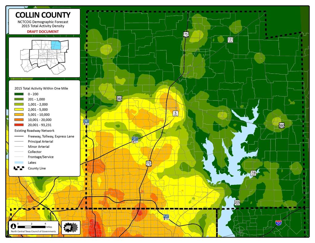
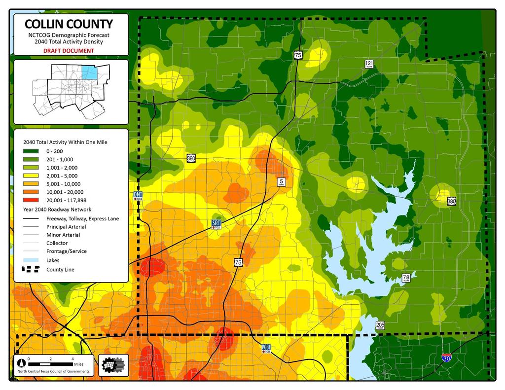
10 Total Population COLLIN COUNTY STRATEGIC ROADWAY PLAN 9 COLLIN COUNTY DEMOGRAPHIC PROJECTION COMPARISON Collin County Population Projections from Various Sources ( ) 3,500,000 SDC 1.0 3,000,000 2,500,000 2,000,000 1,500,000 1,000,000 W&P Perryman COG SDC 0.5 TWDB SDC , Year Actual SDC 1.0 W&P Perryman COG SDC 0.5 TWDB SDC 0.0 SDC Texas State Data Center 0.0, 0.5, & 1.0 migration forecasts; released in 2014 W&P Woods & Poole Economics, Inc.; released in 2015 Perryman The Perryman Group (Ray Perryman); released in 2013 COG NCTCOG 2040 forecast; released in 2015 (year 2045 is from 2017) TWDB Texas Water Development Board; released in 2016
11 Infrastructure 10

 Theoretical Facility Spacing overlaid on Year 2040 Roadway")
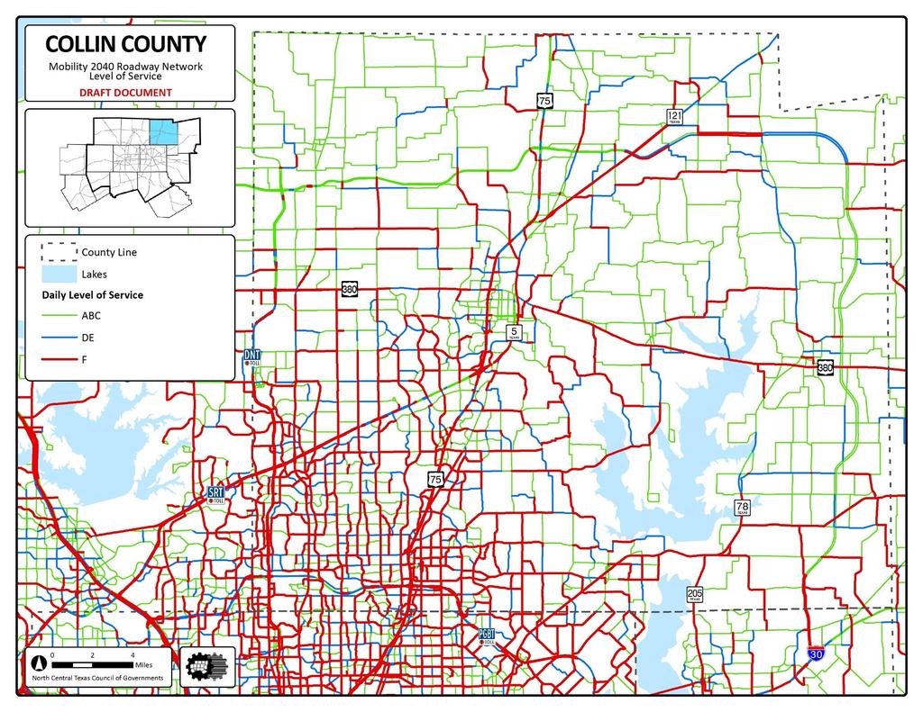
12 COLLIN COUNTY STRATEGIC ROADWAY PLAN 11 FACILITY SPACING IN COLLIN COUNTY Theoretical Facility Spacing (Freeways 10 mi., Principal Arterials 2-5 mi.) Theoretical Facility Spacing overlaid on Year 2040 Roadway Network Freeway Principal Arterial
")

13 Limited Access Roadways (LARs) Comparison , ,673 1,959,449 2,496,859

14 13 Infrastructure Operational Improvements Freeway Arterial Freeway June 2017

15 Computer Simulation Performance Comparison* N/S System N/S System + E/W Option #3 N/S System + E/W Option #4 COUNTY Infrastructure Sept 2017 COLLIN COUNTY DALLAS COUNTY VMT= VHT= Avg. Speed= Control Delay= Cong. Delay= Vehicle Miles or Travel Vehicle Hours of Travel Average Speed Traffic Control Delay Congestion Delay VMT 0% 3% 1% VHT -6% -8% -8% Avg. Speed 7% 11% 10% Control Delay -4% -7% -5% Cong. Delay -16% -22% -23% VMT 0% -1% 0% VHT 0% -2% -1% Avg. Speed 1% 1% 1% Control Delay -1% -2% -1% Cong. Delay -1% -4% -4% ROCKWALL COUNTY HUNT COUNTY VMT 3% 0% -3% VHT -6% -15% -18% Avg. Speed 9% 18% 19% Control Delay -9% -13% -12% Cong. Delay -19% -46% -51% VMT -2% -2% -2% VHT -3% -3% -4% Avg. Speed 1% 2% 2% Control Delay -2% -4% -1% Cong. Delay -8% -12% -16% 12-COUNTY REGION VMT 0% 0% 0% VHT -1% -2% -2% Avg. Speed 1% 2% 2% Control Delay -1% -2% -1% Cong. Delay -3% -6% -5% *compared to CCSRP baseline 14
16 SUMMARY OF UPDATED CCSRP RECOMMENDATIONS
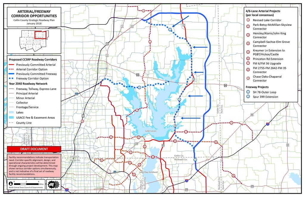
17 COLLIN COUNTY STRATEGIC ROADWAY PLAN 16 CONSIDERATIONS SINCE SEPTEMBER 29, 2017 CCSRP BRIEFING (PLANO): LAKE CORRIDOR FREEWAY Significant public opposition, environmental concerns, and right-of-way conflicts identified in multiple jurisdictions December 12, 2017 City of Wylie Resolution: a. No north-south or east-west freeways permitted within Wylie city limits b. Evaluate feasibility of widening existing Lake Lavon crossings before identifying any new crossings OUTER LOOP As sole freeway east of US 75, Outer Loop determined to be unfeasible/insufficient by 2040 at proposed location Travel demand modeling suggested 2040 feasibility with western realignment to maximize existing SH 78 corridor Critical locations: Farmersville Bypass/US 380; new path between SH 78/FM 6 & FM 1138/FM 2755 intersections EAST-WEST ARTERIALS Travel demand modeling suggested East-West Thoroughfare Option #4A as a technically preferable alternative January 2, 2018 City of Murphy Resolution: a. City of Murphy formally opposed to extend Renner Road east of current Murphy Road terminus b. City of Wylie still agreeable to advance Hensley/Alanis/John King Connector (McCreary Road to SH 205) for further study c. New Lake Ray Hubbard crossing mitigates need to expand recently-finished SH 78 improvements between the lakes
18 17


19 DRAFT CCSRP SH 78 Outer Loop Combo Concept DRAFT Use the purple or orange (FM 545) alignment within the blue South of Blue Ridge corridor from SH 121 to SH 78 Shift west toward the red north/south corridor as SH 78 bypasses the City of Farmersville and intersects US 380 Only difference between North of Blue Ridge & South of Blue Ridge in the original Corridor Evaluation was public input (based on factors different from the present) 18
20 COLLIN COUNTY STRATEGIC ROADWAY PLAN 19 RIGHT-OF-WAY NEEDS FOR SH 78 OUTER LOOP COMBINATION: Since inception, Collin County Outer Loop has been planned with a typical section width of 500 feet: a. Width may accommodate as many as 5 general purpose lanes in each direction b. Median contains future rail envelope In Dallas/Ellis County, Loop 9 is being planned with a typical section width of 350 feet For greater flexibility/efficiency, Loop 9 may be a more appropriate model for the SH 78 Outer Loop Combination option between SH 121 and IH 30
 -6% -8% -5% Average Speed 7% 10% 6% Traffic Control Delay (Hours) -4% -5% -2% Congestion Delay (Hours) -16% -23% -16% DALLAS COUNTY Vehicle Miles of Travel (VMT) 0% 0% 0% -4%")
21 Computer Simulation Performance Comparison N/S System N/S System + SH78/Outer E/W Option Loop #4A Combination 45,000 11, % 51,000 COLLIN COUNTY Vehicle Miles of Travel (VMT) 0% 1% 1% Vehicle Hours of Travel (VHT) -6% -8% -5% Average Speed 7% 10% 6% Traffic Control Delay (Hours) -4% -5% -2% Congestion Delay (Hours) -16% -23% -16% DALLAS COUNTY Vehicle Miles of Travel (VMT) 0% 0% 0% -4% Vehicle Hours of Travel (VHT) 0% -1% -1% Average Speed 1% 1% 1% Traffic Control Delay (Hours) -1% -1% 0% Infrastructure Projected daily volumes in 2040 Baseline listed in blue callout boxes. Percent change from 2040 Baseline in yellow callout boxes. -1% -3% 52,000 25,000-14% 61, % 79,000 46,000 87,000 Congestion Delay (Hours) -1% -4% -3% ROCKWALL COUNTY Vehicle Miles of Travel (VMT) 3% -3% 2% Vehicle Hours of Travel (VHT) -6% -18% -10% Average Speed 9% 19% 13% Traffic Control Delay (Hours) -9% -12% -9% Congestion Delay (Hours) -19% -51% -34% HUNT COUNTY Vehicle Miles of Travel (VMT) -2% -2% -2% Vehicle Hours of Travel (VHT) -3% -4% -4% Average Speed 1% 2% 2% Traffic Control Delay (Hours) -2% -1% -2% Congestion Delay (Hours) -8% -16% -15% -7% 59,000-8% -5% 12-COUNTY REGION Vehicle Miles of Travel (VMT) 0% 0% 0% Vehicle Hours of Travel (VHT) -1% -2% -1% Average Speed 1% 2% 1% Traffic Control Delay (Hours) -1% -1% -1% Congestion Delay (Hours) -3% -5% -4% 22
22 February 8, 2018 CCSRP: SH 78 Outer Loop Combo Concept February 2018 Example Alignment Options for FM 6 FM 1138 Transition Area DRAFT 2755 N 21 Parcel Boundaries FM 3549 Extension Proposed Freeway Alignment Options Grade Separation/Interchange
23 February 13, 2018 CCSRP: SH 78 Outer Loop Combo Concept 2194 Example Alignment Options for SH 78 Farmersville Bypass DRAFT 547 N 22 Parcel Boundaries Proposed Freeway Alignment Options Grade Separation/Interchange
24 COLLIN COUNTY STRATEGIC ROADWAY PLAN 23 SUMMARY OF PRELIMINARY RECOMMENDATIONS FOR MOBILITY 2045: (ALL RECOMMENDATIONS ARE NON-TOLLED) FREEWAY PROJECTS 1. Regional Outer Loop (SH 121 to IH 30) a. Continue to identify previously-planned corridor for staged development b. Evaluate new SH 78 Outer Loop Combination Alternative as a potential replacement option (Illustrative Map) ARTERIAL PROJECTS 1. West Corridor Operational Improvements (FM 1378/Woodbridge Parkway/Merritt Road) 2. SH 78/SH 205/John King Boulevard a. SH 78 same as Mobility 2040; future changes dependent on SH 78 Outer Loop Combination Alternative analysis b. SH 205/John King Boulevard consistency w/ SH 205 Feasibility Study recommendations 3. Lake Corridor (thoroughfare only; no new Lake Lavon bridge based on public input) Corridor #1 and #5 4. East-West Thoroughfare Option #4A (corridor placement awaiting final design results) a. Maximize capacity per local thoroughfare plans (SE Collin/NE Dallas/Rockwall County) Corridor #2, #4, and #6 b. New/expanded thoroughfare facilities Corridor #3 (McCreary Road to SH 205/John King Boulevard), #7, #8, and #9 5. Add FM 3549 and CR 483 extensions (to address Lavon/Collin County concerns w/future SH 78 traffic between lakes) NOTE: Recommendations represent proposed accommodation of needs ONLY; NO proposed project/alignment may proceed to construction WITHOUT completion of formal environmental study AND public involvement process.
25 COLLIN COUNTY STRATEGIC ROADWAY PLAN 24 PUBLIC OUTREACH FOR CCSRP NCTCOG recommends conducting public meetings with potential partners in several locations between Fall 2017 and Spring 2018 for the following purposes: Explain the Collin County Strategic Roadway Plan study process and the current context of draft recommendations. Determine general consensus and discuss potential outcomes related to integrating recommendations into Mobility 2045 and local thoroughfare plans. Mobility 2045 will have an independent public involvement process. Obtain input/feedback in advance of potential environmental studies by TxDOT and/or other partners. Discuss possible construction staging opportunities based on available UTP (10-Year Plan) funds and implications for planned Collin County Bond Program. (maximize additional 10% design and 10% right-of-way funds)
26 COLLIN COUNTY STRATEGIC ROADWAY PLAN 25 COMMITMENT TO ENVIRONMENTAL/ENGINEERING/CONSTRUCTION EFFORTS 1. Advance West Corridor operational improvement components into the next Transportation Improvement Program (TIP). 2. Present revised Lake Corridor (arterial) and potential SH 78/Outer Loop Combination Alternative (freeway) recommendations to indicate need to expedite environmental process so that appropriate public feedback/sentiment can be captured. 3. Continue construction of existing SH 78/SH 205/John King Boulevard corridor sections and investigate where funding gaps exist. 4. Advance environmental procedures to secure Regional Outer Loop right-of-way and advance frontage road construction in northern Collin County (DNT to SH 121). 5. Begin environmental procedures for proposed thoroughfare crossing of Lake Ray Hubbard. 6. Develop master cost/revenue matrix to leverage RTC funds with Collin County, TxDOT, and local governments that incorporates potential staged construction elements. 7. US 75 technology lanes are fully funded and should be implemented as soon as possible. 8. Continue to support TxDOT recommendations for US 380/Spur 399 Extension corridor improvements.
27 COLLIN COUNTY STRATEGIC ROADWAY PLAN 26 CONTACT INFORMATION Michael Morris, P.E. Transportation Director Phone: (817) Dan Lamers, P.E. Senior Program Manager Phone: (817) Jeff Neal, PTP Project Manager Program Manager Phone: (817) Chris Reed Project Manager Senior Transportation Planner Phone: (817) Berrien Barks Principal Planner Phone: (817)
NEW BRAUNFELS SEGUIN AREA REGIONAL TRANSPORTATION DRAFT PLAN NEW BRAUNFELS CITY COUNCIL MEETING
 NEW BRAUNFELS SEGUIN AREA REGIONAL TRANSPORTATION DRAFT PLAN NEW BRAUNFELS CITY COUNCIL MEETING February 13, 2012 This regional transportation plan will: 1. Review existing plans for the cities and counties,
Proposed Project I 35 from Denton to Cooke County Line
 Proposed Project I 35 from Denton to Cooke County Line The existing I 35 facility is four lanes from I 35E/I 35W to Farm to Market Road (FM) 3002. The purpose of the proposed project is to increase capacity
Mobility Greater Johnson County Transportation Coalition. May 23, 2018
 Mobility 2045 Greater Johnson County Transportation Coalition May 23, 2018 Agenda Regional Perspective Mobility Planning Overview Mobility 2045 Draft Recommendations Financial Planning Overview Schedule
Performance Measures Target Setting NCTCOG Public Meetings
 Performance Measures Target Setting NCTCOG Public Meetings October 8,15,18, 2018 Performance-Based Planning Mobility 2045 Regional Goals Performance Measures Measure System Performance and Report Progress
BASS PRO DRIVE TO: WEST OF FARM-TO-MARKET ROAD (FM)
") NOTICE OF PUBLIC MEETING INTERSTATE HIGHWAY 30 (Rockwall) FROM: BASS PRO DRIVE TO: WEST OF FARM-TO-MARKET ROAD (FM) 2642 CSJs: 0009-11-238; 0009-12-215; 0009-12-908 Dallas County and Rockwall County, Texas
NOTICE OF PUBLIC MEETING INTERSTATE HIGHWAY 30 (Rockwall) FROM: BASS PRO DRIVE TO: WEST OF FARM-TO-MARKET ROAD (FM) 2642 CSJs: 0009-11-238; 0009-12-215; 0009-12-908 Dallas County and Rockwall County, Texas
Best Southwest Transportation Committee. North Central Texas Council of Governments Transportation Department
 Best Southwest Transportation Committee North Central Texas Council of Governments Transportation Department The The Regional Regional Veloweb Veloweb Review Review NCTCOG Bicycle and Pedestrian Program
Short and Long Term Needs
 Short and Long Term Needs The short- and long-term programs of proposed projects listed below have been designed to address the mobility issues in South Montgomery County. These improvements to the transportation
APPENDIX G: INTERSECTION NEEDS AT OKEECHOBEE BOULEVARD
 APPENDIX G: INTERSECTION NEEDS AT OKEECHOBEE BOULEVARD INTERSECTION NEEDS AT SR 7 and OKEECHOBEE BOULEVARD SR 7 Extension Project Development and Environment (PD&E) Study From Okeechobee Boulevard (SR
10 Year Plan Cost/Revenue Matrix for the Dallas Fort Worth Region FY 2017 FY 2028
 Collin 54005 2351 01 017 FM 2478 FM 1461 to US 380 Collin 54005.1 2351 02 014 FM 2478 Collin 55038 2679 03 015 FM 2514 FM 1461 to North of FM 1461 East of Lavon Parkway to North of Drain Drive Widen two
PUBLIC COMMENTS REPORT WRITTEN COMMENTS SUBMITTED BY WEBSITE, & SOCIAL MEDIA
 PUBLIC COMMENTS REPORT Purpose WRITTEN COMMENTS SUBMITTED BY WEBSITE, EMAIL & SOCIAL MEDIA The public comments report is in accordance with the NCTCOG Transportation Department Public Participation Process,
6/14/2013. Welcome. to the US 75 Corridor Study. Public Meeting. US 75 Corridor Study Area
 Welcome to the US 75 Corridor Study Public Meeting US 75 Corridor Study Area 1 Existing and Future Congestion Levels 2012 2035 A do-nothing approach does not address the severe congestion in the region
WEST AND SOUTH WEST RING ROAD DOWNSTREAM TRAFFIC IMPACTS
 Page 1 of 9 EXECUTIVE SUMMARY Alberta Transportation ( AT ) is preparing to construct the final sections of the Calgary Ring Road. This includes the South West Ring Road ( SWRR ) (from Lott Creek Blvd
Sponsored By: Support From:
 Sponsored By: Support From: A voluntary association of local governments, H-GAC provides a regional forum for cooperative action. Created by Texas, role defined by State and local governments: Area Agency
I-20 ODESSA-MIDLAND CORRIDOR STUDY. Public Meeting for Schematic Design
 I-20 ODESSA-MIDLAND CORRIDOR STUDY Public Meeting for Schematic Design The environmental review, consultation, and other actions required by applicable Federal environmental laws for this project are being,
STREET AND HIGHWAY PLAN
 STREET AND HIGHWAY PLAN Introduction The street and highway system in the Winston-Salem Urban Area consists of thousands of miles of traffic carrying facilities, ranging from short local residential streets
FY STIP. Austin District. November Quarterly Revisions HIGHWAY STATEWIDE TRANSPORTATION IMPROVEMENT PROGRAM
 FY 2011-2014 STIP STATEWIDE TRANSPORTATION IMPROVEMENT PROGRAM HIGHWAY Austin District November Quarterly Revisions November 2011 FY 2011-2014 Transportation Improvement Program Amendments October 10,
CHIEF PEGUIS TRAIL EXTENSION WEST
 1 PRELIMINARY DESIGN OF THE CHIEF PEGUIS TRAIL EXTENSION WEST Public Information Session June 6, 2017 Welcome 1 Thank you for attending today s public information session. The following boards provide
FM 1092/Murphy Road Access Management Study Pulic Meeting #1. Wednesday, August 31, :00 p.m. 8:00 p.m.
 FM 1092/Murphy Road Access Management Study Pulic Meeting #1 Wednesday, August 31, 2011 6:00 p.m. 8:00 p.m. Introductions Agency Partners H-GAC Missouri City TxDOT Introductions Consulting Team In Association
VDOT I-66 Inside the Beltway Eastbound Widening Environmental Assessment. Staff Recommendations
 VDOT I-66 Inside the Beltway Eastbound Widening Environmental Assessment Staff Recommendations Department of Environmental Services Transportation January 28, 2017 Timeline of Transform66 June 2012: I-66
4. ENVIRONMENTAL IMPACT ANALYSIS 9. TRANSPORTATION AND TRAFFIC
 4. ENVIRONMENTAL IMPACT ANALYSIS 9. TRANSPORTATION AND TRAFFIC 4.9.1 INTRODUCTION The following section addresses the Proposed Project s impact on transportation and traffic based on the Traffic Study
STUDY ADVISORY COMMITTEE. October 8, 2015
 STUDY ADVISORY COMMITTEE October 8, 2015 Study Purpose evaluate the long-term transportation strategies and investments needed to sustain the county s economic health and quality of life in the coming
PEDESTRIAN ACTION PLAN
 ATTACHMENT 2 CITY OF SANTA MONICA PEDESTRIAN ACTION PLAN CITY OF SANTA MONICA PEDESTRIAN ACTION PLAN This page intentionally left blank EXECUTIVE SUMMARY CHAPTER 1 EXECUTIVE SUMMARY Setting the Stage
TABLE OF CONTENTS 7.0 THOROUGHFARE PLAN. Analysis of Future Conditions Thoroughfare Plan Proposed Cross-Sections.. 7.
 TABLE OF CONTENTS 7.0 THOROUGHFARE PLAN Analysis of Future Conditions.. 7.2 Thoroughfare Plan.. 7.3 Proposed Cross-Sections.. 7.4 Arterials Minor Arterials Collectors Local Streets Thoroughfare Plan Map
ACTIVE TRANSPORTATION
 ACTIVE TRANSPORTATION Mobility 2040 Supported Goals Improve the availability of transportation options for people and goods. Support travel efficiency measures and system enhancements targeted at congestion
I-35 Corridor Segment Committee NW Loop 410 San Antonio, Texas. February 11, :00 AM to Noon
 I-35 Corridor Segment Committee 4 3500 NW Loop 410 San Antonio, Texas February 11, 2010 9:00 AM to Noon Welcome Nancy Parker Facilitator Committee Work Session Nancy Parker Facilitator Discussion of Proposed
Corridor Advisory Group and Task Force Meeting #10. July 27, 2011
 Corridor Advisory Group and Task Force Meeting #10 July 27, 2011 1 Agenda Recap CAG/TF #9 Public Meeting #2 Summary Single Mode Alternatives Evaluation Results Next Steps 2 3 CAG/TF #9 Recap CAG /TF #9
M-58 HIGHWAY ACCESS MANAGEMENT STUDY Mullen Road to Bel-Ray Boulevard. Prepared for CITY OF BELTON. May 2016
 M-58 HIGHWAY ACCESS MANAGEMENT STUDY Prepared for CITY OF BELTON By May 2016 Introduction Missouri State Highway 58 (M-58 Highway) is a major commercial corridor in the City of Belton. As development has
Transportation Master Plan Advisory Task Force
 Transportation Master Plan Advisory Task Force Network Alternatives & Phasing Strategy February 2016 BACKGROUND Table of Contents BACKGROUND Purpose & Introduction 2 Linking the TMP to Key Council Approved
IH 20 RANGER HILL PUBLIC MEETING
 IH 20 RANGER HILL PUBLIC MEETING AUGUST 25, 2015 IH 20, Eastland County, TX CSJ 0007-06-084 IH 20 from 3.5 mi. East of LP 254 to SH 16 (Ranger Hill) August 25, 2015 Agenda Introductions Purpose of the
City of Homewood Transportation Plan
 City of Homewood Transportation Plan Prepared for: City of Homewood, Alabama Prepared by: Skipper Consulting, Inc. May 2007 TABLE OF CONTENTS INTRODUCTION... 1 BACKGROUND INFORMATION... 1 EXISTING TRANSPORTATION
Introduction. Project Need
 Introduction The purpose of Subtask 1 of the SR 54/56 Project Concept Development (PCD) Study is to identify and summarize the goals and proposed operations for transit corridor improvements as depicted
TRANSPORTATION ASSESSMENT
 TRANSPORTATION ASSESSMENT Traffic Modeling The mobility findings analysis for Dallas was based on the methodology of the North Central Texas Council of Government s Regional travel demand model. This model
Introduction...pg. 1. Study Area...pg. 1. Study Purpose and Need...pg. 2. Study Coordination and Development... pg. 3. Public Involvement...pg.
 Table of Contents Introduction...pg. 1 Study Area...pg. 1 Study Purpose and Need...pg. 2 Study Coordination and Development... pg. 3 Public Involvement...pg. 4 Evaluation of Alternatives...pg. 4 Preferred
RESOLUTION NO ?? A RESOLUTION OF THE CITY OF NEPTUNE BEACH ADOPTING A COMPLETE STREETS POLICY
 RESOLUTION NO. 2018-?? A RESOLUTION OF THE CITY OF NEPTUNE BEACH ADOPTING A COMPLETE STREETS POLICY WHEREAS, safe, convenient, and accessible transportation for all users is a priority of the City of Neptune
List of Display Boards
 List of Display Boards Welcome Introduction Municipal Class Environmental Assessment (EA) Process Need and Justification for an Interchange Alternatives for Evaluation Vertical and Horizontal Alignments
I-25 PEL: CO Springs Denver South Connection. Presentation to Castle Rock Town Council
 I-25 PEL: CO Springs Denver South Connection Presentation to Castle Rock Town Council June 20, 2017 An Important Corridor to Colorado Links the state s two major metropolitan areas and communities between
Washington DC Section of ITE Project Briefing
 Washington DC Section of ITE Project Briefing November 5, 2015 Renée Hamilton, VDOT, Deputy District Administrator I-66 Outside the Beltway Improvement Area Project Location Virginia 2 Purpose and Need
FI-2 I-66 Between Route 29, Lee Highway and Route 15, James Madison Highway
 TRANSPORTATION PLAN INTENT Transportation is the key to the economic and social development of Prince William County and especially to the I 66/Route 29 Sector Plan area. This includes transportation for
MASTER THOROUGHFARE PLAN
 MASTER THOROUGHFARE PLAN Master Thoroughfare Plan Update November 2015 Prepared for Town of Northlake AVO 30659 11/11/2015 1201 North Bowser Road Richardson, Texas 75081 Firm Registration No. 312 MASTER
York Region Population and Employment Growth
 March 1, 2016 1 York Region Population and Employment Growth York Region needs to comply with The Provincial Growth Plan and new forecasts introduced to 2036 and 2041 2 Regional Official Plan Review York
Maryland State Highway Mobility Report. Morteza Tadayon
 Maryland State Highway Mobility Report Morteza Tadayon Background Mobility is a Key Performance Area (KPA) in the SHA Business Plan SHA adopts a performance based approach Monitors Highway System to identify
Access Management Regulations and Standards
 Access Management Regulations and Standards January 2014 Efficient highway operation Reasonable property access Concept of Access Management The way to manage access to land development while preserving
Oldham County Major Thoroughfare Plan
 Prepared for: Oldham County Planning & Zoning Commission Prepared by: December 2003 Table of Contents I. INTRODUCTION...1 A. Contents of Report...1 B. Purpose of Study...2 C. Related Project Documents...2
METHODOLOGY. Signalized Intersection Average Control Delay (sec/veh)
") Chapter 5 Traffic Analysis 5.1 SUMMARY US /West 6 th Street assumes a unique role in the Lawrence Douglas County transportation system. This principal arterial street currently conveys commuter traffic
Chapter 5 Traffic Analysis 5.1 SUMMARY US /West 6 th Street assumes a unique role in the Lawrence Douglas County transportation system. This principal arterial street currently conveys commuter traffic
GENERAL DESCRIPTION. Page 1 of 5
 38. SH 114/SH 121 Corridor The DFW Connector : FT1345, FT 1347, FT1424, FR1424, FT1425, FR1425, FT1440, FT1500, FR1500, FT1505, FR1505, FT1507, FR1507, FT1510, FR1510, FT1715, FR1715, FT2720, FR2720, HM8190
NORTH HOUSTON HIGHWAY IMPROVEMENT PROJECT DRAFT NEED AND PURPOSE
 NORTH HOUSTON HIGHWAY IMPROVEMENT PROJECT DRAFT NEED AND PURPOSE APPROVED BY FHWA: JULY 2010 UPDATED: OCTOBER 2011 Section 1 Need for and Purpose of Proposed Action Per Council on Environmental Quality
CITY OF FRANKLIN, TENNESSEE. Columbia Avenue. Widening & Improvements Project. Public Meeting May 16, 2017
 CITY OF FRANKLIN, TENNESSEE Columbia Avenue Widening & Improvements Project Public Meeting May 16, 2017 Agenda 6:00 6:30 Formal Presentation 6:30 8:00 Town Hall Forum City of Franklin Columbia Avenue Alternatives
State Road 54/56 Tampa Bay s Northern Loop. The Managed Lane Solution Linking I-75 to the Suncoast Parkway
 State Road 54/56 Tampa Bay s Northern Loop The Managed Lane Solution Linking I-75 to the Suncoast Parkway SUNCOAST PARKWAY Both I 75 and the Suncoast Parkway are planning, or in the process of constructing,
I-395 Express Lanes Northern Extension Project Public Hearings
 I-395 Express Lanes Northern Extension Project Public Hearings Susan Shaw, PE, Megaprojects Director Virginia Department of Transportation Amanda Baxter, Special Projects Manager Virginia Department of
Highway 49, Highway 351 and Highway 91 Improvements Feasibility Study Craighead County
 Highway 49, Highway 351 and Highway 91 Improvements Feasibility Study Craighead County Executive Summary March 2015 Highway 49, Highway 351 and Highway 91 Improvements Feasibility Study Craighead County
Executive Summary June 2015
 Executive Summary June 2015 Highway 112 Corridor Study Benton and Washington Counties Executive Summary June 2015 Prepared by Transportation Planning and Policy Division Arkansas State Highway and Transportation
NCTCOG 16-County Crash and Fatality Data
 North Central Texas Council of Governments - Traffic Safety Crash and Fatality Statistics NORTH CENTRAL TEXAS COUNCIL OF GOVERNMENTS (NCTCOG) 2012 Safety Program Performance Measures NCTCOG 16-County Crash
Attachment One. Integration of Performance Measures Into the Bryan/College Station MPO FY 2019 FY 2022 Transportation Improvement Program
 Attachment One Integration of Performance Measures Into the Bryan/College Station MPO FY 2019 FY 2022 Transportation Improvement Program Introduction Begun as part of the Moving Ahead for Progress in the
Basalt Creek Transportation Refinement Plan Recommendations
 Basalt Creek Transportation Refinement Plan Recommendations Introduction The Basalt Creek transportation planning effort analyzed future transportation conditions and evaluated alternative strategies for
NORTH HOUSTON HIGHWAY IMPROVEMENT PROJECT
 NORTH HOUSTON HIGHWAY IMPROVEMENT PROJECT Project Briefing Packet April 2015 RECOMMENDED ALTERNATIVES Project divided into 3 Segments Segment 1 Beltway 8 to I-610 Segment 2 I-610 to I-10 Segment 3 Downtown
Click to edit Master title style
 Route N Study Community Advisory Group (CAG) Meeting #2 December 12, 2018 Click Agenda to edit Master title style Introductions Recap of the CAG Meeting #1 and Public Meeting #1 Purpose & Need Review Review
Proposed Action, Purpose and Need Technical Memorandum
 Proposed Action, Purpose and Need Technical Memorandum MoPac (State Loop 1) Intersections, Austin District From North of Slaughter Lane to South of La Crosse Avenue CSJ: 3136-01-015 Travis County, Texas
City of Sammamish. Welcome. Issaquah-Fall City Road Improvements Project Phase I Design: 242nd Avenue SE to Klahanie Drive SE
 Welcome Welcome to the third community meeting for the Issaquah-Fall City Road Improvements Project. AGENDA 6:00 p.m. Welcome and sign-in 6:10 p.m. Presentation 6:50 p.m. Open house Learn about the roadway
I-35 COMAL COUNTY OPERATIONAL IMPROVEMENTS
 I- COMAL COUNTY OPERATIONAL IMPROVEMENTS OPEN HOUSE The environmental review, consultation, and other actions required by applicable Federal environmental laws for this project are being, or have been,
Public Information Meeting
 Richmond Highway (U.S. Route 1) Corridor Improvements Public Information Meeting Tuesday, April 18, 2017 Mount Vernon High School 8515 Old Mt. Vernon Road, Alexandria, VA 22309 Amanda Baxter, VDOT, Special
CITY MANUALS AND STANDARDS REVIEW
 GEORGETOWN SIDEWALK MASTER PLAN CITY MANUALS AND STANDARDS REVIEW RESOURCES AND STANDARDS As part of the Master Plan process, a review and evaluation of current City documents and policies relevant to
Mobility and Congestion
 Technical Memorandum Mobility and Congestion Prepared for: Prepared by: September 25, 2013 1 Table of Contents 1. Introduction... 1 2. Congestion Forecasting Process... 1 2.1 Mobility and Congestion Terms...
MoPac South: Impact on Cesar Chavez Street and the Downtown Network
 MoPac South: Impact on Cesar Chavez Street and the Downtown Network Prepared by: The University of Texas at Austin Center for Transportation Research Prepared for: Central Texas Regional Mobility Authority
University Hill Transportation Study Technical Memorandum Alternatives Modeling and Analysis May 2007
 Technical Memorandum May 2007 Syracuse Metropolitan Transportation Council Edwards and Kelcey with Wallace Roberts and Todd Alta Planning and Design CONTENTS SECTION ONE- INTRODUCTION...1 SECTION TWO-
Recommended Roadway Plan Section 2 - Land Development and Roadway Access
 Recommended Roadway Plan Section 2 - Land Development and Roadway Access SECTION 2 Land Development and Roadway Access 2.1 Land Use and Access Management The Federal Highway Administration (FHWA) defines
Chapter 5 Future Transportation
 Chapter 5 Future Transportation The Future Land Use Plan identifies the desired land use designations. The land uses desired for Crozet depend, in large part, on the success of the transportation system,
Intersection Traffic Control Feasibility Study
 Intersection Traffic Control Feasibility Study CSAH 9 at CSAH 60 (185th Avenue) Prepared For: Dakota County Transportation Department Western Service Center 14955 Galaxie Avenue, 3rd Floor Apple Valley,
US 69 RELIEF ROUTE STUDY
 US 69 RELIEF ROUTE STUDY Jacksonville, Texas PUBLIC MEETING #2 May 29 th, 2018 Welcome to the public meeting for the US 69 Relief Route Study in Jacksonville. This is the second public meeting for this
County of Fairfax, Virginia. Department of Transportation
 Fairfax County Parkway History 2 Planning began 50 years ago 1960s Washington s Regional Transportation Plan Recommends improved north/south travel Construct Capital Beltway and outer beltway Outer beltway
Southwest Bus Rapid Transit (SW BRT) Functional Planning Study - Executive Summary January 19 LPT ATTACHMENT 2.
 Functional Planning Study - Executive Summary January 19 LPT ATTACHMENT 2.") Southwest Bus Rapid Transit (SW BRT) Functional Planning Study - Executive Summary 2011 January 19 1 of 19 Introduction This executive summary presents the results of the Southwest Bus Rapid Transit (SW
Southwest Bus Rapid Transit (SW BRT) Functional Planning Study - Executive Summary 2011 January 19 1 of 19 Introduction This executive summary presents the results of the Southwest Bus Rapid Transit (SW
Arlington County 10-Year Transit Development Plan & Premium Transit Network Briefing. May 2016
 Arlington County 10-Year Transit Development Plan & Premium Transit Network Briefing May 2016 Overview 10-Year Transit Development Plan Premium Transit Network Columbia Pike service concept Premium amenities
PREFERRED ALTERNATIVE IMPLEMENTATION PLAN. Prepared for. Ohio Department of Transportation, District South SR 741 Lebanon, Ohio 45036
 HAM-32F-0.00 PID 86461 PREFERRED ALTERNATIVE IMPLEMENTATION PLAN Prepared for Ohio Department of Transportation, District 8 505 South SR 741 Lebanon, Ohio 45036 Prepared by URS Corporation 564 White Pond
Hennepin County Pedestrian Plan Public Comment Report
 Hennepin County Pedestrian Plan Public Comment Report On May 31, 2013, the draft Hennepin County Pedestrian Plan was released for a 45-day public comment period ending July 15, 2013. The county received
The Role of MPOs in Advancing Safe Routes to School through the Transportation Alternatives Program
 The Role of MPOs in Advancing Safe Routes to School through the Transportation Alternatives Program In 2012, Congress made changes to Federal funding for Safe Routes to School that gave some metropolitan
Houma-Thibodaux Metropolitan Planning Organization STP<200K Funding Application APPLICATION
 APPLICATION HOUMA-THIBODAUX METROPOLITAN PLANNING ORGANIZATION (HTMPO) FOR SURFACE TRANSPORTATION PROGRAM (STP
Bicycle Master Plan Goals, Strategies, and Policies
 Bicycle Master Plan Goals, Strategies, and Policies Mobilizing 5 This chapter outlines the overarching goals, action statements, and action items Long Beach will take in order to achieve its vision of
Portland International Airport Bicycle and Pedestrian Plan (October 2003) Staff Acknowledgements
 Staff Acknowledgements") Portland International Airport Bicycle and Pedestrian Plan (October 2003) Staff Acknowledgements Scott King, Senior Aviation Planner Jason Gately, Senior Aviation Planner Preston Beck, Associate Planner
Portland International Airport Bicycle and Pedestrian Plan (October 2003) Staff Acknowledgements Scott King, Senior Aviation Planner Jason Gately, Senior Aviation Planner Preston Beck, Associate Planner
LOOP 360 IMPROVEMENT STUDY
 LOOP 360 IMPROVEMENT STUDY Overview and Preliminary Analysis August 2015 1 STUDY PROCESS 2 Study Background Loop 360 serves a wide range of users, including residents, businesses, bicyclists, and commuters
Project Description Form 8EE
 Project Description Form 8EE Basic Project Information Submitting Jurisdiction/Agency: Town of Dumfries Project Title: Route 1 (Fraley Blvd) Widening: Brady's Hill Road to Dumfries Road Project Location:
City of Wayzata Comprehensive Plan 2030 Transportation Chapter: Appendix A
 A1. Functional Classification Table A-1 illustrates the Metropolitan Council s detailed criteria established for the functional classification of roadways within the Twin Cities Metropolitan Area. Table
Master Development Plan for the TxDOT North Tarrant Express Project, Segments 2-4. Chapter 3: Draft List of Facilities.
 Table of Contents 3.1. Interim vs. Ultimate Configuration for the Remaining Segments of NTE... 1 3.2. Characteristics of Project Segments... 3 3.2.1. All Segments... 5 3.2.2. Segment 2E... 8 3.2.3. Segment
SH-6 Corridor Improvement Study Policy Committee Progress Report M O N D AY, J U N E 1 0, B R A Z O S C E N T E R
 SH-6 Corridor Improvement Study Policy Committee Progress Report M O N D AY, J U N E 1 0, 2 0 1 3 B R A Z O S C E N T E R Project Overview Study Goals and Objectives» Improve traffic flow» Reduce delay»
Managed Lanes. Steve Schilke, P.E. Major Projects Unit Head District 1. Illinois Traffic Engineering and Safety Conference October 2016
 Managed Lanes Steve Schilke, P.E. Major Projects Unit Head District 1 Illinois Traffic Engineering and Safety Conference October 2016 Agenda Managed Lanes Projects I-55 (Stevenson Expressway) Express Toll
Corporate. Report COUNCIL DATE: June 26, 2006 NO: C012 COUNCIL-IN-COMMITTEE. TO: Mayor & Council DATE: June 22, 2006
 Corporate NO: C012 Report COUNCIL DATE: June 26, 2006 COUNCIL-IN-COMMITTEE TO: Mayor & Council DATE: June 22, 2006 FROM: General Manager, Engineering FILE: 0410-20(MoT/Gate) SUBJECT: Surrey Response on
Viewing SMART SCALE Application
 Viewing SMART SCALE Application Route 15 Whites Ferry Road to Points of Rock Bridge Project Status: Submitted Organization: Loudoun County Project ID: 3593 Submitted: 08/06/2018 @ 3:18PM by Bob Brown Created:
Welcome. Thank you for your interest in the Lewis & Clark Viaduct Concept Study
 Welcome Thank you for your interest in the Lewis & Clark Viaduct Concept Study Please use the arrows in the upper left hand corner to navigate through the presentation. Use the envelope icon to ask a question
AAMPO MOBILITY PROJECT DISCUSSION. July/August 2015
 AAMPO MOBILITY PROJECT DISCUSSION July/August 2015 Proposition 1 FY 16 & 17 $1.74 billion transferred to State Highway Fund in FY 2015 $147.3 million let in SAT district in FY 2015 US 90, IH 10, IH 410
Denton County. Thoroughfare Plan. Draft: December
 Thoroughfare Plan Draft: December January 19, 2017 Draft: 2015 TABLE OF CONTENTS CHAPTER 1. BASIS FOR THE PLAN... 1 Purpose of the Plan... 1 Current Transportation Plans Influencing... 1 CHAPTER 2. TRANSPORTATION
Final Project Prioritization Plan
 Final Project Prioritization Plan For the NM 599 Corridor Executive Summary I. EXECUTIVE SUMMARY NM 599 serves as a North/South by-pass for vehicles traveling through Santa Fe and a WIPP route for low
Route 29 Corridor Assessment Update. Development of Possible Solutions
 Route 29 Corridor Assessment Update Development of Possible Solutions Public Workshop #3 October 27, 2016 Purpose of Developing Possible Solutions Recap of where we ve been and timeline for moving forward
Scottsdale Road/Rural Road Alternatives Analysis (AA) Study. Arizona ITE/IMSA Spring Conference March 7, 2012
 Study. Arizona ITE/IMSA Spring Conference March 7, 2012") Scottsdale Road/Rural Road Alternatives Analysis (AA) Study Arizona ITE/IMSA Spring Conference March 7, 2012 Study Location and Duration Primary Study Corridor (major focus of effort) Rural Road and Scottsdale
Scottsdale Road/Rural Road Alternatives Analysis (AA) Study Arizona ITE/IMSA Spring Conference March 7, 2012 Study Location and Duration Primary Study Corridor (major focus of effort) Rural Road and Scottsdale
NCTCOG 16-County Crash and Fatality Data
 North Central Texas Council of Governments - Traffic Safety Crash and Fatality Statistics NORTH CENTRAL TEXAS COUNCIL OF GOVERNMENTS (NCTCOG) 2013 Safety Program Performance Measures NCTCOG 16-County Crash
Lee s Summit Road Improvement Study Public Open House June 7, 2007 Summary of Comment Card Responses
 Lee s Summit Road Improvement Study Public Open House June 7, 2007 Summary of Comment Card Responses Introduction At the Lee s Summit Road Improvement Study Public Open House held Thursday, June 7, 2007
Pattullo Bridge Replacement Project Community Connections Phase 2 Consultation. Appendix 3: Open House Display Boards
 Replacement Project Community Connections Phase 2 Consultation Appendix 3: Open House Display Boards November 2016 Welcome! Welcome to the Replacement Project Public Open House We Want to Hear from You
TRASBURG RANSPORTATION
 TRASBURG RANSPORTATION LAN DEVELOPED BY THE TRANSPORTATION PLANNING DIVISION OF THE VIRGINIA DEPARTMENT OF TRANSPORTATION IN COOPERATION WITH THE U.S. DEPARTMENT OF TRANSPORTATION, FEDERAL HIGHWAY ADMINISTRATION
Municipal Class EA To Address Traffic Congestion On The Ontario Street Corridor (Grand Bend) Public Information Meeting June 4, 2018
 Public Information Meeting June 4, 2018") Municipal Class EA To Address Traffic Congestion On The Ontario Street Corridor (Grand Bend) Public Information Meeting June 4, 2018 Background Agenda Traffic Study Update Class EA Alternatives Bridge
Municipal Class EA To Address Traffic Congestion On The Ontario Street Corridor (Grand Bend) Public Information Meeting June 4, 2018 Background Agenda Traffic Study Update Class EA Alternatives Bridge
JONESBORO HIGHWAY 63 HIGHWAY 18 CONNECTOR STUDY
 JONESBORO HIGHWAY 63 HIGHWAY 18 CONNECTOR STUDY Craighead County May 2007 JONESBORO HIGHWAY 63 HIGHWAY 18 CONNECTOR STUDY Craighead County May 2007 Prepared by Planning and Research Division Arkansas State
I-395 Express Lanes Northern Extension Project Crystal City Civic Association September 21, 2016
 I-395 Express Lanes Northern Extension Project Crystal City Civic Association September 21, 2016 Mike Snare, PE, Project Manager Virginia Department of Transportation GEC Michelle Holland, Megaprojects
PRELIMINARY DRAFT FIRST AMENDMENT TO VISION 2050: A REGIONAL LAND USE AND TRANSPORTATION PLAN FOR SOUTHEASTERN WISCONSIN
 PRELIMINARY DRAFT FIRST AMENDMENT TO VISION 2050: A REGIONAL LAND USE AND TRANSPORTATION PLAN FOR SOUTHEASTERN WISCONSIN ESTABLISHING TARGETS FOR FEDERAL PERFORMANCE MEASURES: HIGHWAY SAFETY SOUTHEASTERN
Arterial Management Plan for US Route 250 and State Route 623
 Arterial Management Plan for US Route 250 and State Route 623 June 25, 2014 Brad Shelton, AICP Access Management and Traffic Impact Analysis Programs Manager Transportation and Mobility Planning Division